
Multi Criteria Decision Analysis to Optimise Siting of Electric Vehicle Charging Points—Case Study Winchester District, UK


 , and
, and
Abstract
:1. Introduction
2. Current State of Art Related to the Considered Problem
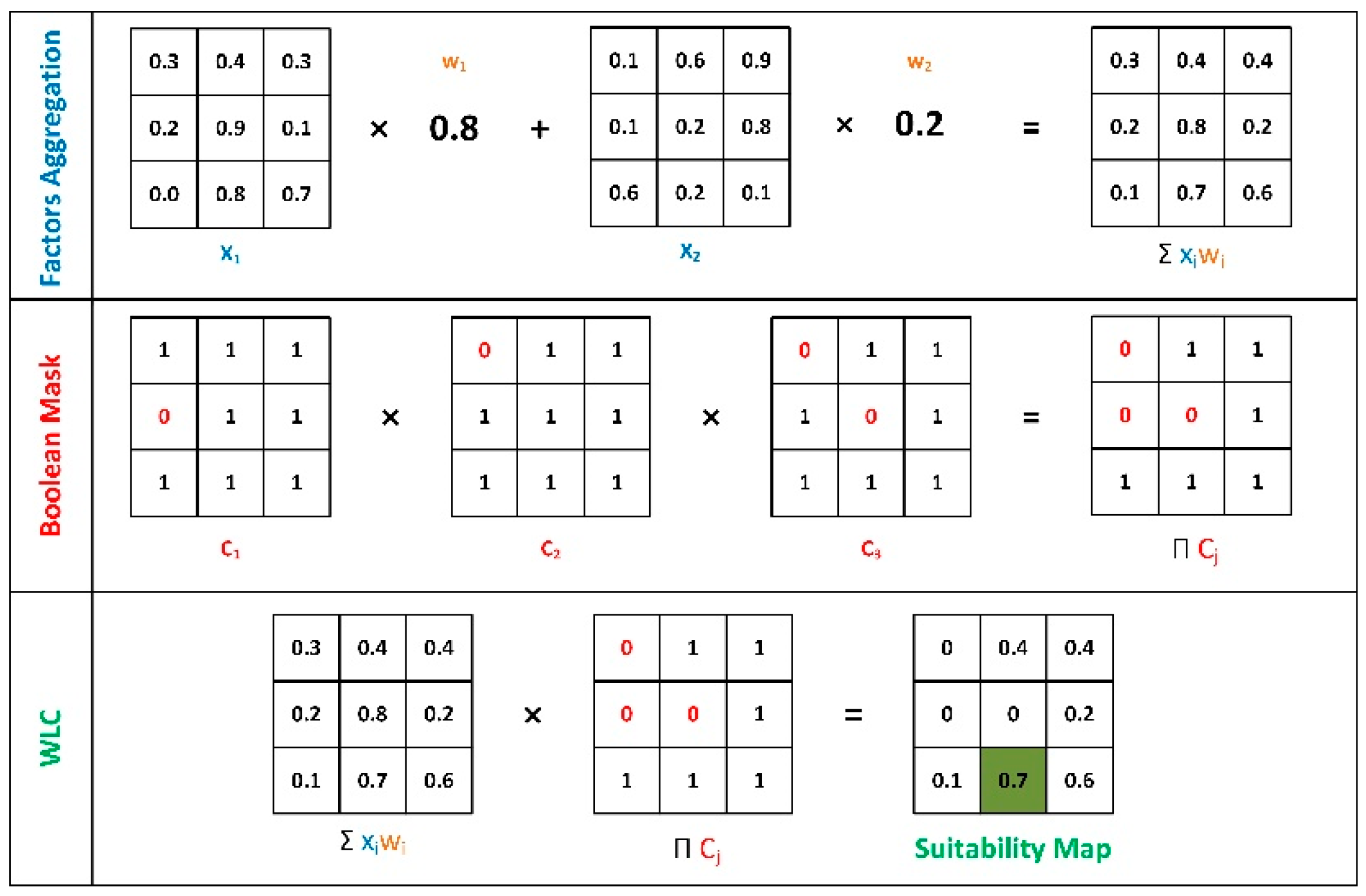
3. Methodology
4. EV Charge Point Siting Criteria, Analysis and Suitability Maps
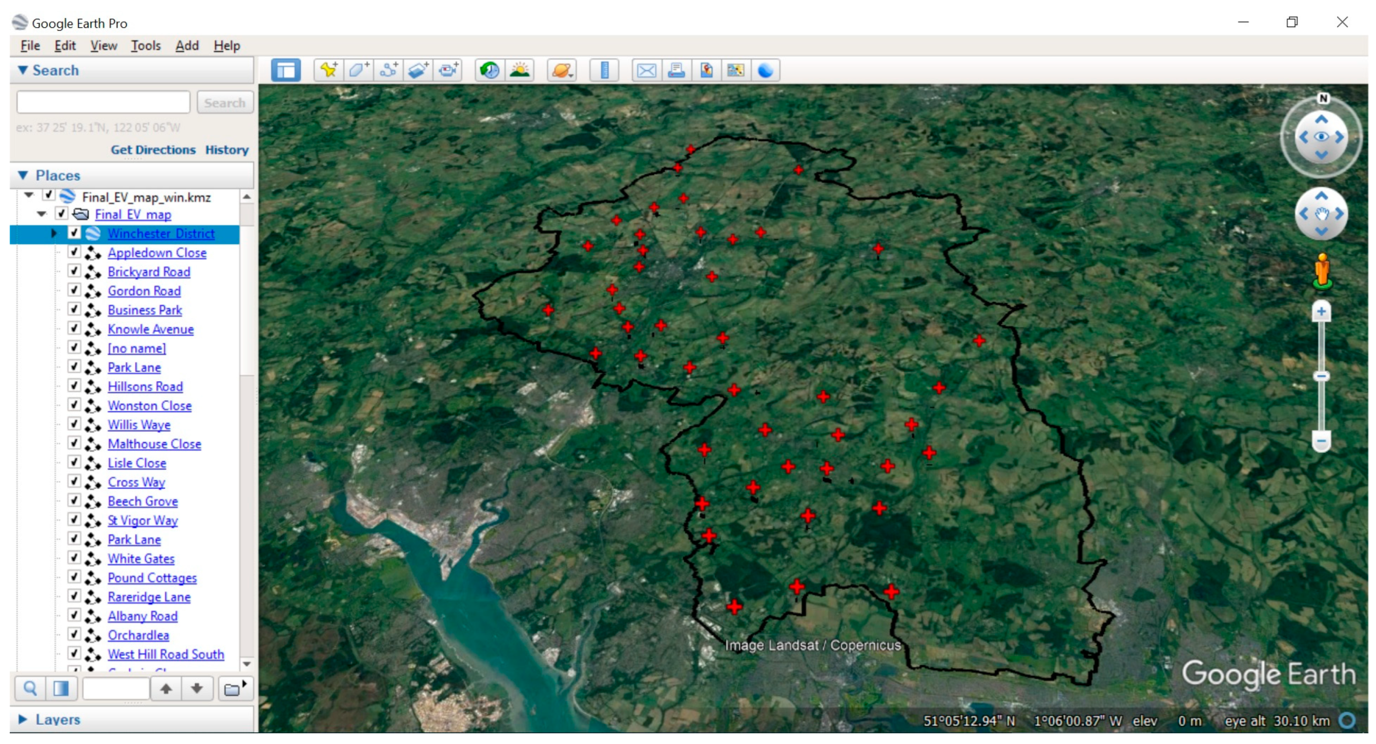
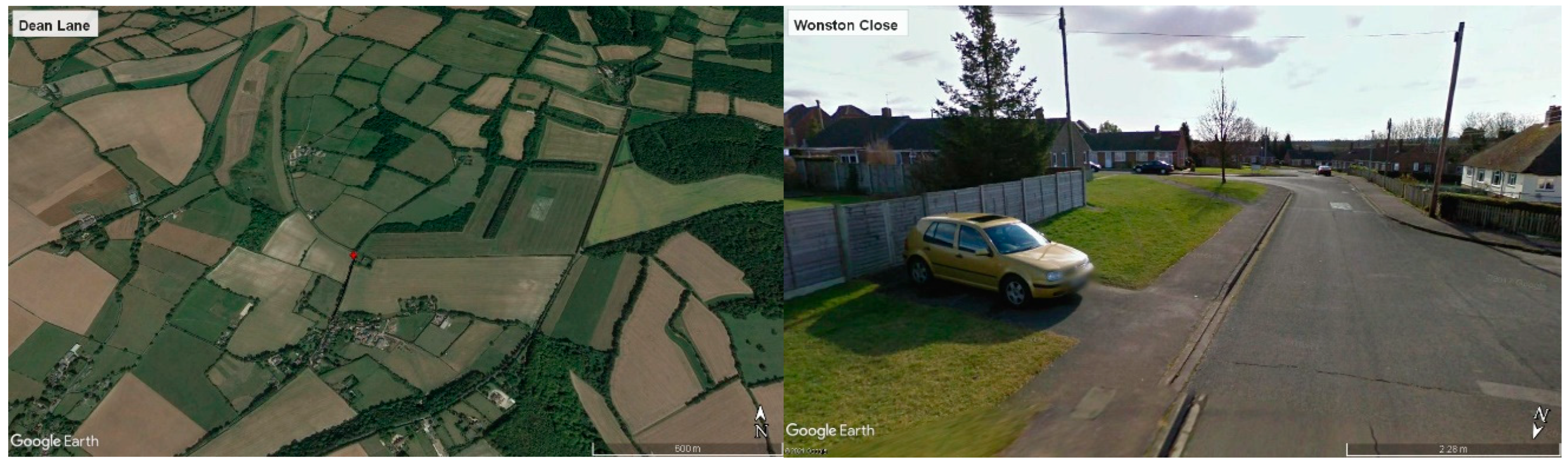
4.1. Visual Validation and Final Results
4.2. Electrical Charging Infrastructure Characteristic
5. Conclusions
Author Contributions
Funding
Acknowledgments
Conflicts of Interest
References
- Department for Businssses (Energy & Industrial Strategy). UK Becomes the First Major Economy to Pass Net Zero Emissions Law. June 2019. Available online: https://bit.ly/2YvP9pG (accessed on 7 October 2021).
- Bahaj, A.; Turner, P.; Mahdy, M.; Leggett, S.; Wise, N.; Alghamdi, A. Environmental assessment platform for cities racing to net zero. In Journal of Physics: Conference Series; IOP Publishing: Bristol, UK, 2021. [Google Scholar]
- Institute for Government. UK Emissions by Sector. February 2020. Available online: https://bit.ly/3iFIujG (accessed on 7 October 2021).
- Climate Change Committee. Net Zero—The UK’s Contribution to Stopping Global Warming. May 2019. Available online: https://bit.ly/2YtGMuI (accessed on 7 October 2021).
- Climate Emergency. List of Councils Who Have Declared a Climate Emergency. February 2021. Available online: https://bit.ly/2ZgJtR6 (accessed on 7 October 2021).
- Winchester City Council. Carbon Neutrality Action Plan; Winchester City Council: Wichester, UK, 2021.
- Department for Business (Energy and Industrial Strategy). Government Takes Historic Step Towards Net-Zero with End of Sale of New Petrol and Diesel Cars by 2030. Available online: https://bit.ly/2WNPxz4 (accessed on 7 October 2021).
- Horizon Power and Energy. Electric Vehicle Charging Study for Winchester City Centre and District; Horizon Power and Energy: Winchister, UK, 2018. [Google Scholar]
- Department for Transport and Driver and Vehicle Licensing. All Vehicles (VEH01). December 2020. Available online: https://bit.ly/2YressK (accessed on 7 October 2021).
- Department for Transport and Driver and Vehicle Licensing. VEH0134 Licensed Ultra-Low Emissions Vehicles by Postcode District: United Kingdom. December 2020. Available online: https://bit.ly/3uQ6WDP (accessed on 7 October 2021).
- Hirst, D.; Winnett, J.; Hinson, S. Electric Vehicles and Infrastructure; House of Commons: London, UK, 2021. [Google Scholar]
- Winchester City Council. District’s Electric Vehicle Charging Point Roll out Beings in Denmead. November 2020. Available online: https://bit.ly/3Fsr4Rm (accessed on 7 October 2021).
- Winchester City Council. Nearly 50 Electric Vehicle Charging Points Earmarked for the Winchester District. 2020. Available online: https://bit.ly/3aeeW8r (accessed on 7 October 2021).
- Erbaş, M.; Kabak, M.; Özceylan, E.; Çetinkaya, C. Optimal siting of electric vehicle charging stations: A GIS-based fuzzy Multi-Criteria Decision Analysis. Energy 2018, 163, 1017–1031. [Google Scholar] [CrossRef]
- Guler, D.; Yomralioglu, T. Suitable location selection for the electric vehicle fast charging station with AHP and fuzzy AHP methods using GIS. Ann. GIS 2020, 26, 169–189. [Google Scholar] [CrossRef] [Green Version]
- Guo, S.; Zhao, H. Optimal site selection of electric vehicle charging station by using fuzzy TOPSIS based on sustainability perspective. Appl. Energy 2015, 158, 39–402. [Google Scholar] [CrossRef]
- Sierpiński, G.; Staniek, M.; Kłos, M.J. Decision making support for local authorities choosing the method for siting of in-city ev charging stations. Energies 2020, 13, 4682. [Google Scholar] [CrossRef]
- Zhang, Y.; Iman, K. A multi-factor GIS method to identify optimal geographic locations for electric vehicle (EV) charging stations. Proc. Int. Cartogr. Assoc. 2017, 1, 127. [Google Scholar] [CrossRef] [Green Version]
- Bahaj, A.S.; Mahdy, M.; Alghamdi, A.S.; Richards, D.J. New approach to determine the Importance Index for developing offshore wind energy potential sites: Supported by UK and Arabian Peninsula case studies. Renew. Energy 2020, 152, 441–457. [Google Scholar] [CrossRef]
- Mahdy, M.; Bahaj, A.S. Multi criteria decision analysis for offshore wind energy potential in Egypt. Renew. Energy 2018, 118, 278–289. [Google Scholar] [CrossRef]
- Saaty, T.L. Decision making with the analytic hierarchy process. Int. J. Serv. Sci. 2008, 1, 83–98. Available online: https://www.rafikulislam.com/uploads/resourses/197245512559a37aadea6d.pdf (accessed on 7 October 2021).
- Saaty, T.L. Decision making with the analytic hierarchy process. Sci. Iran. 2002, 9, 215–229. Available online: http://scientiairanica.sharif.edu/article_2696.html (accessed on 7 October 2021).
- Mahdy, M.; Bahaj, A.S.; Alghamdi, A.S. Offshore wind energy potential around the east coast of the Red Sea, KSA. In Proceedings of the IEA SHC International Conference on Solar Heating and Cooling for Buildings and Industry, Abu Dhabi, United Arab Emirates, 29 October–2 November 2017. [Google Scholar]
- Department for Transport. The Highway Code. March 2021. Available online: https://bit.ly/3iBL1vi (accessed on 7 October 2021).
- Chen, T.; Zhang, X.-P.; Wang, J.; Li, J.; Wu, C.; Hu, M.; Bian, H. A review on electric vehicle charging infrastructure development in the UK. J. Mod. Power Syst. Clean Energy 2020, 8, 193–205. [Google Scholar] [CrossRef]
- Sutton, E.; Medyckyj-Scott, D.; Urwin, T. The EDINA Digimap® Service–10 Years On. Cartogr. J. 2007, 44, 268–275. [Google Scholar] [CrossRef]
- Hoback, A.; Anderson, S.; Dutta, U. True walking distance to transit. Transp. Plan. Technol. 2008, 31, 681–692. [Google Scholar] [CrossRef]
- Walker, J. Walking Distance to Transit. April 2011. Available online: https://bit.ly/3DbHxrk (accessed on 7 October 2021).
- Wu, H.; Alberts, G.; Hopper, J.; Walton, B. New Market. New Entrants. New Challenges. In Battery Electric Vehicles; Deloitte LLP: London, UK, 2019; Available online: https://bit.ly/3oH2k20 (accessed on 7 October 2021).
- London, H. Planning Advice Note: Installing Electric Vehicle Charging Points; Transport for London: London, UK, 2021.
- Office for Zero Emission Vehicles. On-Street Residential Chargepoint Scheme Guidance for Local Authorities. Available online: https://bit.ly/3nEBQfZ (accessed on 20 January 2022).
- UK Department for Transport. Electric Vehicle Charging in Residential and Non-Residential Buildings; UK Department for Transport: London, UK, 2019.
- Hampshire County Council. Ampshire Illuminated Street Furniture. Available online: https://bit.ly/33BDSa7 (accessed on 20 January 2022).
- Scottish and Southern Electricity Networks. EV Connections. Available online: www.ssen.co.uk/Connections/EVconnections/ (accessed on 1 March 2022).


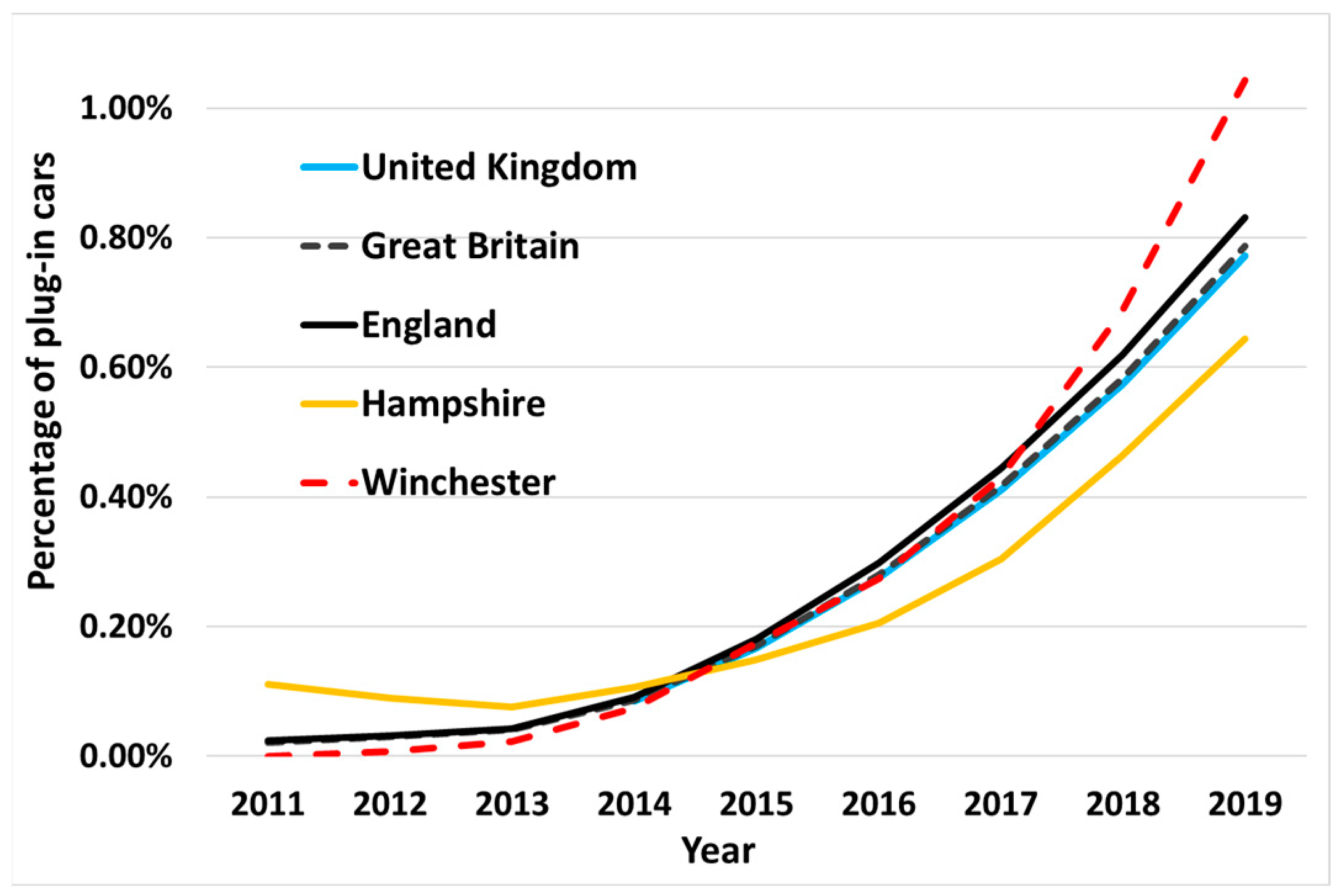
| Region | Cars Registered (2020) | Plug Ins Registered (2020) | Percentage (2020) |
|---|---|---|---|
| UK | 38,582,000 | 433,784 | 1.12% |
| England | 32,408,880 | 394,743 | 1.22% |
| Hampshire | 964,550 | 9977 | 1.03% |
| Winchester | 88,739 | 1301 | 1.47% |
| Constraint | Description |
|---|---|
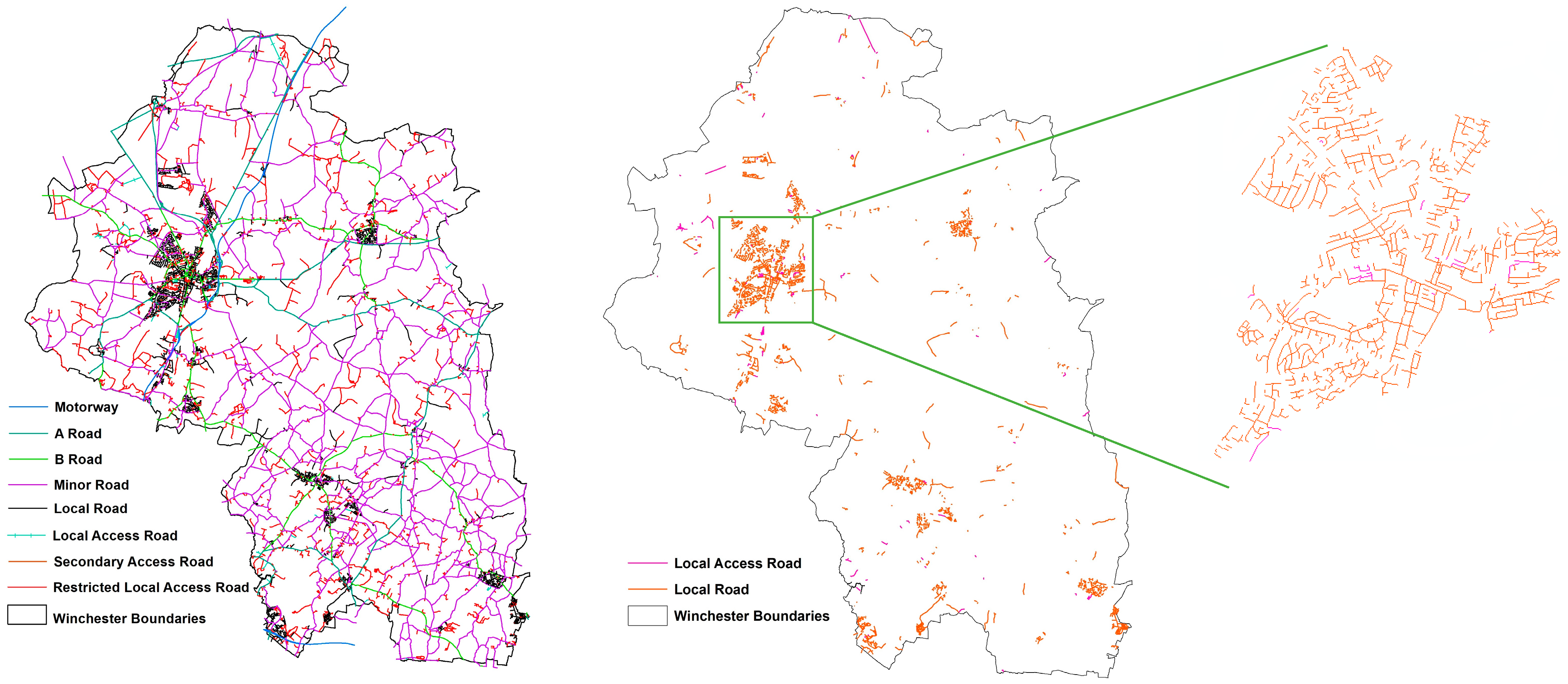
| 1. Road type. | All roads with a speed limit greater than 30 mph, including motorways, dual carriageways and A-roads, were excluded for safety reasons and to comply with rule 249 of the Highway Code, where a vehicle must display parking lights when parked overnight on a road with a speed limit greater than 30 mph [24]. |
| 2. Road access. | All roads mapped as having Restricted Local Access, such as the road that provides alternate/secondary access to property or land not intended for through traffic, were excluded from the analysis in order to ensure equal access to all. |
| 3. On-road parking. | Roads typically with limited or no on-road parking availability (B-roads, minor roads and secondary-access roads) were also excluded. |
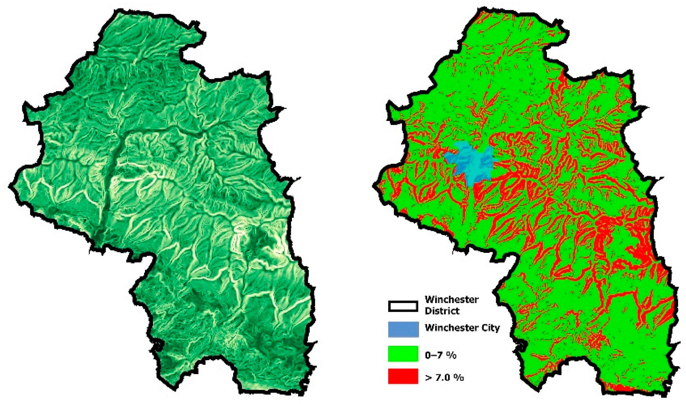
| 4. Road slope. | Roads with a slope of greater than 7% were excluded to (a) prevent potential breakdown hazards and (b) reduce electricity consumption from driving on the said slope [14]. |
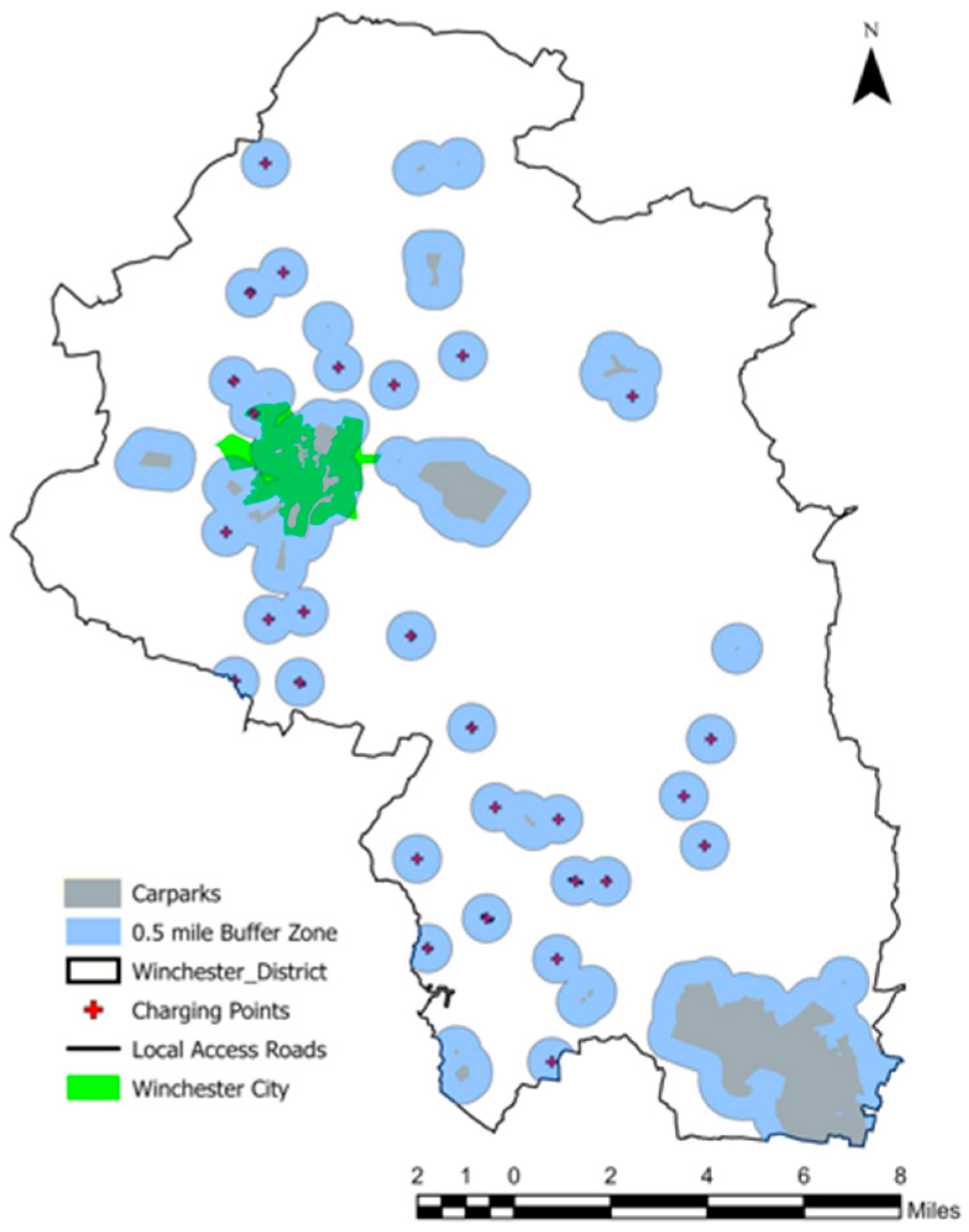
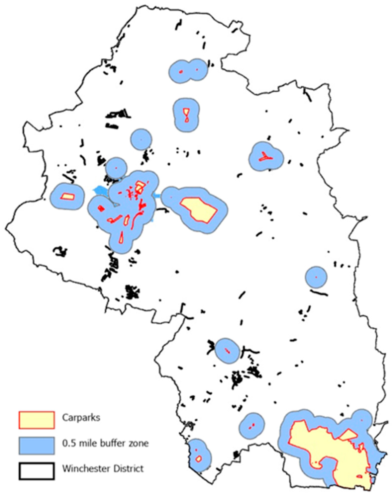
| 5. EV charging points. | A buffer zone for current and future EV charging points or stations within the District was created to exclude nearby roads (within a 0.5-mile radius). It must be noted that all current and future EV charging points were located within or next to a car park; therefore, this criterion was merged with criterion 6. |
| 6. Car parks. | The literature recommends the installation of one charging point for each 25–50 car parking space [25]. Considering this and WCCs plans, as set out in the Electric Vehicle Charging Strategy [13], a buffer zone was created around all suitably sized car parks to exclude all streets within a 0.5-mile radius. |
| Suitability Factor | Description |
|---|---|
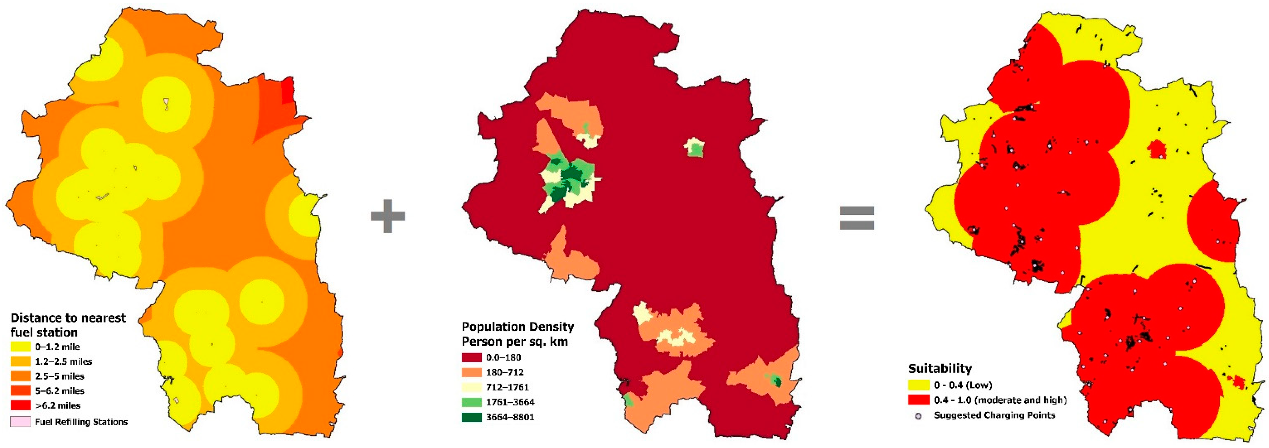
| 1. Petrol stations | Roads with greater proximity to petrol stations are considered more suitable for EV charging points, in particular for hybrid EV drivers. |
| 2. Population distribution | Roads in densely populated areas will be considered more suitable as each charge point will cater for a greater number of people. |
| 3. Low-voltage electrical network | Provision of EV charge points will add additional electrical load to the local network; therefore, sites should be considered in terms of the relative resilience of the low-voltage electrical network. |
| 4. Off-road parking | Houses with off-road parking facilities on own property are more likely to be able to install and operate a personal EV charging point. |
| 5. EV ownership | Areas with relatively high levels of EV ownership are considered more suitable as they are likely to have higher usage. |
| No. | Segment Number | Street Name | Parking Availability | Slope < 7% | Proximity to Populated Area | Action | /New Suggested Road |
|---|---|---|---|---|---|---|---|
| 1 | 158 | Appledown Close | ✓ | ✓ | ✓ | No further action | |
| 2 | 336 | Dean Lane | x | ✓ | x | Excluded | |
| 3 | 380 | Floud Lane | x | ✓ | ✓ | Attempt to relocate | No suitable roads nearby |
| 4 | 399 | Shavard Lane | x | ✓ | ✓ | Attempt to relocate | Pound Cottages |
| 5 | 531 | Jervis Court Lane | x | ✓ | ✓ | Attempt to relocate | Rareridge Lane |
| 6 | 557 | Tangier Lane | x | ✓ | ✓ | Attempt to relocate | Albany Road |
| 7 | 640 | Brickyard Road | ✓ | ✓ | ✓ | No further action | |
| 8 | 654 | No name | x | ✓ | x | Excluded | |
| 9 | 705 | Gordon Road | ✓ | ✓ | ✓ | No further action | |
| 10 | 723 | Business Park | ✓ | ✓ | ✓ | No further action | |
| 11 | 892 | Knowle Avenue | ✓ | ✓ | ✓ | No further action | |
| 12 | 918 | Lee Ground | x | ✓ | ✓ | Attempt to relocate | No suitable roads nearby |
| 13 | 1319 | No name | ✓ | ✓ | ✓ | No further action | |
| 14 | 1324 | Park Lane | ✓ | ✓ | ✓ | No further action | |
| 15 | 1333 | No name | x | ✓ | x | Excluded | |
| 16 | 1336 | Bere Farm Lane | x | ✓ | x | Excluded | |
| 17 | 1346 | Cott Street Lane | x | ✓ | ✓ | Attempt to relocate | Orchardlea |
| 18 | 1355 | No name | x | ✓ | ✓ | Attempt to relocate | No suitable roads nearby |
| 19 | 1459 | Hillsons Road | ✓ | ✓ | ✓ | No further action | |
| 20 | 1493 | No name | x | ✓ | x | Excluded | |
| 21 | 1523 | Wonston Close | ✓ | ✓ | ✓ | No further action | |
| 22 | 1570 | No name | x | ✓ | ✓ | Attempt to relocate | West Hill Road South |
| 23 | 1745 | Willis Waye | ✓ | ✓ | ✓ | No further action | |
| 24 | 1754 | Chilland Lane | x | ✓ | ✓ | Attempt to relocate | Old Station Road |
| 25 | 2202 | Malthouse Close | ✓ | ✓ | ✓ | No further action | |
| 26 | 2402 | Sarum Close | x | ✓ | ✓ | Attempt to relocate | No suitable roads nearby |
| 27 | 2488 | Chilcomb Lane | x | ✓ | ✓ | Attempt to relocate | No suitable roads nearby |
| 28 | 2799 | Connaught Road | x | ✓ | ✓ | Attempt to relocate | Blackwell Road |
| 29 | 2810 | No name | x | ✓ | x | Excluded | |
| 30 | 2833 | North Drive | x | ✓ | ✓ | Attempt to relocate | Valley Road |
| 31 | 2915 | Old Hillside Road | x | ✓ | ✓ | Attempt to relocate | Godwin Close |
| 32 | 2966 | No name | x | ✓ | x | Excluded | No suitable roads nearby |
| 33 | 3031 | Lisle Close | ✓ | ✓ | ✓ | No further action | |
| 34 | 3043 | Hurdle Way | x | ✓ | ✓ | Attempt to relocate | No suitable roads nearby |
| 35 | 3098 | Park Lane | x | ✓ | ✓ | Attempt to relocate | Queen Street |
| 36 | 3139 | Cross Way | ✓ | ✓ | ✓ | No further action | |
| 37 | 3158 | Beech Grove | ✓ | ✓ | ✓ | No further action | |
| 38 | 3259 | St Vigor Way | ✓ | ✓ | ✓ | No further action | |
| 39 | 3289 | No name | x | ✓ | ✓ | Attempt to relocate | No suitable roads nearby |
| 40 | 3319 | Park Lane | ✓ | ✓ | ✓ | No further action | |
| 41 | 3332 | Popes Lane | x | ✓ | ✓ | Attempt to relocate | Widlers Lane |
| 42 | 3339 | White Gates | ✓ | ✓ | ✓ | No further action | |
| 43 | 3340 | No name | x | ✓ | x | Excluded | |
| 44 | 3360 | New Farm Road | x | ✓ | ✓ | Attempt to relocate | No suitable roads nearby |
| Road | Parish | Postcode | A (Miles) | Parking Spaces | Available Lamp Columns | Required Charging Points for the Location |
|---|---|---|---|---|---|---|
| Appledown Close | New Alresford | SO24 9ND | 0.6 | 17 | 2 | 2 |
| Brickyard Road | Swanmore | SO32 2PJ | 1.5 | 30 | 4 | 3 |
| Gordon Road | Curdridge | SO32 2BE | 2.2 | 82 | 9 | 7 |
| Culverlands | Shedfield | SO32 2JF | 1 | 23 | 0 | Excluded |
| Knowle Avenue | Wickham | PO17 5LG | 3.6 | 19 | 3 | 2 |
| Long Road | Soberton | SO32 3PG | 3.2 | 19 | 2 | 2 |
| Park Lane | Droxford | SO32 3QR | 3.2 | 18 | 0 | Excluded |
| Hilsons Road | Curdridge | SO30 2DY | 2.2 | 37 | 0 | Excluded |
| Wonston Close | Wonston | SO21 3LQ | 3.2 | 32 | 3 | 3 |
| Willis Waye | Kings Worthy | SO23 7QT | 0.9 | 27 | 3 | 3 |
| Malthouse Close | Chilcomb | SO21 1ES | 1.3 | 20 | 0 | Excluded |
| Lisle Close | Olivers Battery | SO22 4JZ | 0.7 | 15 | 2 | 2 |
| Cross Way | Compton | SO21 2BZ | 1.2 | 34 | 4 | 3 |
| Beech Grove | Owslebury | SO21 1LS | 3.1 | 35 | 4 | 3 |
| St Vigor Way | Colden Common | SO21 1UU | 1.5 | 66 | 14 | 5 |
| Park Lane | Otterbourne | SO21 2HY | 2.6 | 61 | 0 | Excluded |
| White Gates | Durley | SO32 2AS | 2.4 | 18 | 0 | Excluded |
| Pound Cottages | Corhampton | SO32 3NP | 2.0 | 37 | 3 | 3 |
| Rareridge Lane | Bishops Waltham | SO32 1DX | 0.6 | 26 | 3 | 2 |
| Albany Road | Bishops Waltham | SO32 1BW | 0.7 | 21 | 6 | 2 |
| Orchardlea | Swanmore | SO32 2QZ | 1.9 | 56 | 8 | 5 |
| West Hill Road | South Wonston | SO21 3HP | 3.1 | 17 | 2 | 2 |
| Godwin Close | St Barnabas Ward | SO22 5JN | 0.5 | 39 | 7 | 3 |
| Widlers Lane | Upham | SO32 1JE | 4.9 | 40 | 0 | Excluded |
| Blackwell Road | South Wonston | SO21 2QX | 1.8 | 98 | 9 | 8 |
| Valley Road | Littleton | SO22 6QZ | 0.8 | 38 | 4 | 4 |
| Old Station Road | Itchen Abbas | SO21 1BA | 1.7 | 15 | 0 | Excluded |
| Queen Street | Twyford | SO21 1QG | 1.1 | 25 | 2 | 2 |
Publisher’s Note: MDPI stays neutral with regard to jurisdictional claims in published maps and institutional affiliations. |
© 2022 by the authors. Licensee MDPI, Basel, Switzerland. This article is an open access article distributed under the terms and conditions of the Creative Commons Attribution (CC BY) license (https://creativecommons.org/licenses/by/4.0/).
Share and Cite
Mahdy, M.; Bahaj, A.S.; Turner, P.; Wise, N.; Alghamdi, A.S.; Hamwi, H. Multi Criteria Decision Analysis to Optimise Siting of Electric Vehicle Charging Points—Case Study Winchester District, UK. Energies 2022, 15, 2497. https://doi.org/10.3390/en15072497
Mahdy M, Bahaj AS, Turner P, Wise N, Alghamdi AS, Hamwi H. Multi Criteria Decision Analysis to Optimise Siting of Electric Vehicle Charging Points—Case Study Winchester District, UK. Energies. 2022; 15(7):2497. https://doi.org/10.3390/en15072497
Chicago/Turabian StyleMahdy, Mostafa, AbuBakr S. Bahaj, Philip Turner, Naomi Wise, Abdulsalam S. Alghamdi, and Hidab Hamwi. 2022. "Multi Criteria Decision Analysis to Optimise Siting of Electric Vehicle Charging Points—Case Study Winchester District, UK" Energies 15, no. 7: 2497. https://doi.org/10.3390/en15072497
APA StyleMahdy, M., Bahaj, A. S., Turner, P., Wise, N., Alghamdi, A. S., & Hamwi, H. (2022). Multi Criteria Decision Analysis to Optimise Siting of Electric Vehicle Charging Points—Case Study Winchester District, UK. Energies, 15(7), 2497. https://doi.org/10.3390/en15072497