
The Application of Geographical Information Systems and the Analytic Hierarchy Process in Selecting Sustainable Areas for Urban Green Spaces: A Case Study in Hue City, Vietnam


 , ,
, ,
Abstract
1. Introduction
2. Materials and Methods
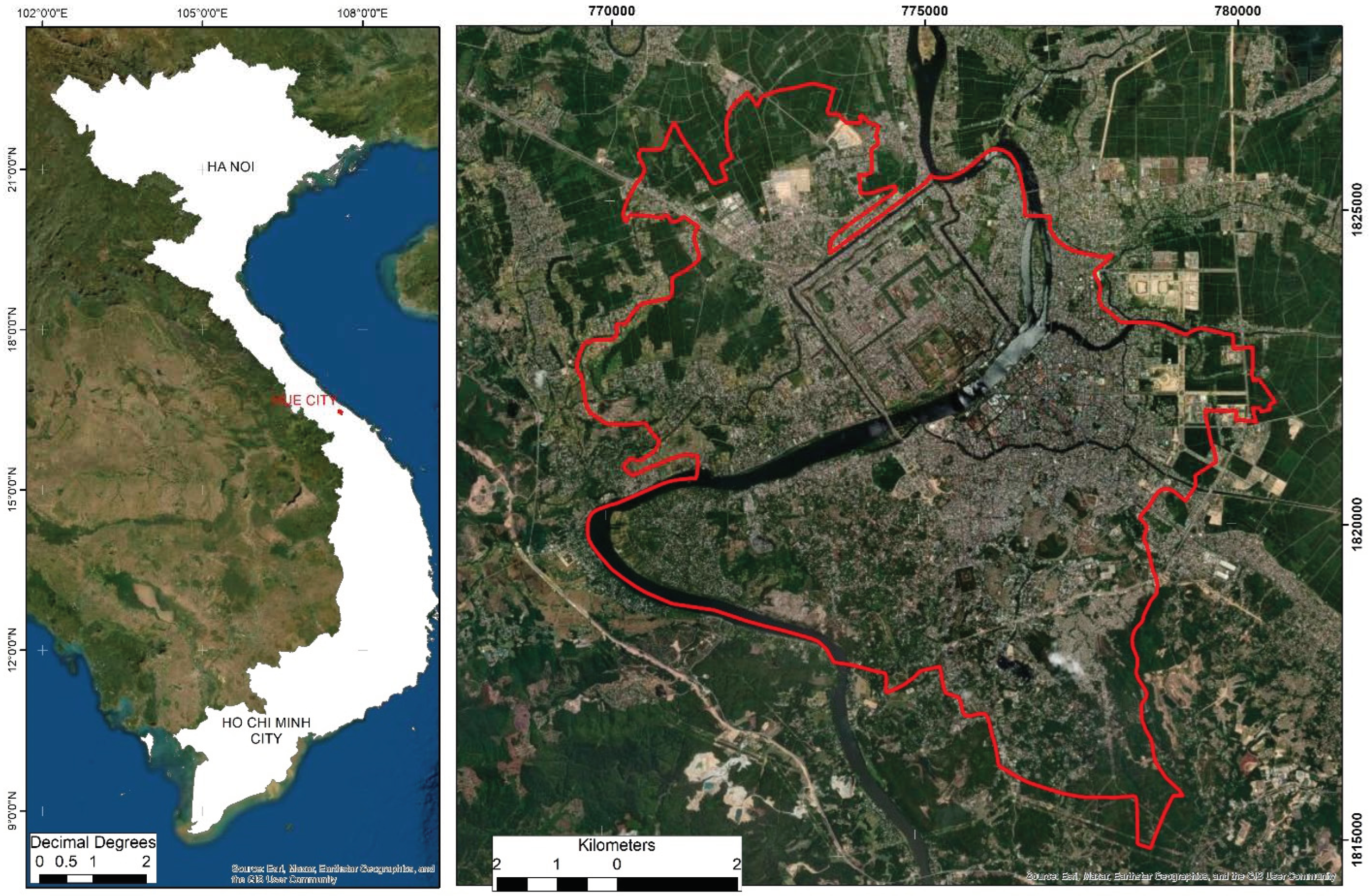
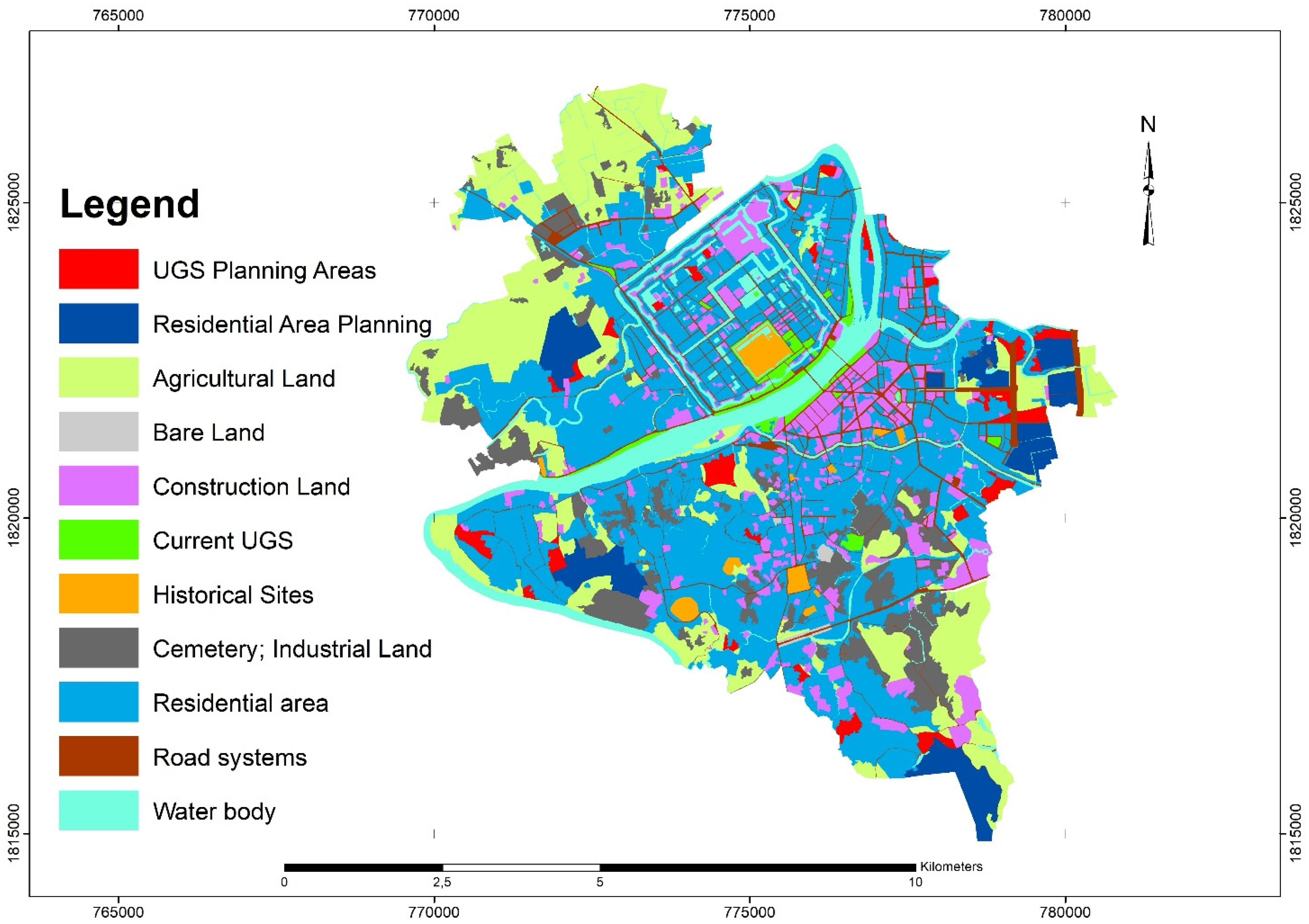
2.1. Research Site
2.2. Methods
2.2.1. Focus Group Discussion
2.2.2. Geographical Information System and Remote Sensing
2.2.3. The Analytic Hierarchy Process (AHP)
- Step 1—selection of criteria and setting up a hierarchy structure.
- Step 2—pairwise comparison.
- is the important level of criteria compared to criteria ;
- is the important level of criteria compared to criteria by participant th;
- is the number of participants in the discussion.
- is the normalized value of ;
- is the sum of by column from matrix A;
- is the number of compared criteria.
- is the weight of criteria
- the is sum of by row from matrix B
- Step 3—validation of the prioritized level.
- is the consistency ratio;
- is the consistency index (CI) obtained by calculating:
- Step 4—scoring for the characteristics of each criterion.
- Step 5—calculate the final score of each land map unit and the suitability classifications.
3. Results
3.1. The Selection of Criteria
3.2. Criteria Weights and Scores
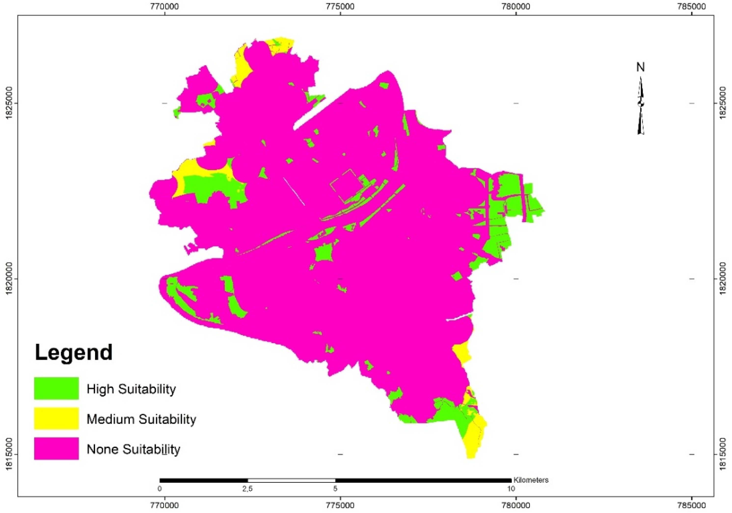
3.3. Suitability Map for Urban Green Spaces in Hue City
- (i)
- The UGS must belong to a highly suitable class, as shown in the suitability map.
- (ii)
- The UGS should be close to existing as well as developing residential areas.
- (iii)
- The UGS should have a minimum size of 1 hectare.
- (iv)
- The ratio of UGS per capita must meet the regulations set forward by the government, with a minimum of 6 m2 per capita, where the estimated population in 2030 will be 400,000 people.
4. Discussion
5. Conclusions
Author Contributions
Funding
Institutional Review Board Statement
Informed Consent Statement
Data Availability Statement
Conflicts of Interest
References
- Kabisch, N.; Qureshi, S.; Haase, D. Human–environment interactions in urban green spaces—A systematic review of contemporary issues and prospects for future research. Environ. Impact Assess. Rev. 2015, 50, 25–34. [Google Scholar] [CrossRef]
- Taylor, L.; Hochuli, D.F. Creating better cities: How biodiversity and ecosystem functioning enhance urban residents’ wellbeing. Urban Ecosyst. 2015, 18, 747–762. [Google Scholar] [CrossRef]
- World Health Organization. Urban Green Spaces: A Brief for Action; World Health Organization: Copenhagen, Denmark, 2017.
- Bertram, C.; Rehdanz, K. The role of urban green space for human well-being. Ecol. Econ. 2015, 120, 139–152. [Google Scholar] [CrossRef]
- Şenik, B.; Uzun, O. A process approach to the open green space system planning. Landsc. Ecol. Eng. 2022, 18, 203–219. [Google Scholar] [CrossRef]
- Li, F.; Sutton, P.C.; Anderson, S.J.; Nouri, H. Planning green space in Adelaide city: Enlightenment from green space system planning of Fuzhou city (2015–2020). Aust. Plan. 2017, 54, 126–133. [Google Scholar] [CrossRef]
- Egorov, A.I.; Pierpaolo, M.; Matthias, B.; Marco, M. Urban Green Spaces and Health: A Review of Evidence; WHO: Copenhagen, Denmark, 2016.
- Chiesura, A. The role of urban parks for the sustainable city. Landsc. Urban Plan. 2004, 68, 129–138. [Google Scholar] [CrossRef]
- Jabbar, M.; Yusoff, M.M.; Shafie, A. Assessing the role of urban green spaces for human well-being: A systematic review. GeoJournal 2021, 1–19. [Google Scholar] [CrossRef]
- Wong, N.H.; Yu, C. Study of green areas and urban heat island in a tropical city. Habitat Int. 2005, 29, 547–558. [Google Scholar] [CrossRef]
- Liu, W.; Zhao, H.; Sun, S.; Xu, X.; Huang, T.; Zhu, J. Green Space Cooling Effect and Contribution to Mitigate Heat Island Effect of Surrounding Communities in Beijing Metropolitan Area. Front. Public Health 2022, 10, 870403. [Google Scholar] [CrossRef]
- Gherraz, H.; Guechi, I.; Alkama, D. Quantifying the effects of spatial patterns of green spaces on urban climate and urban heat island in a semi-arid climate. Bull. Société R. Sci. Liège 2020, 89, 164–185. [Google Scholar] [CrossRef]
- Zimmermann, E.; Bracalenti, L.; Piacentini, R.; Inostroza, L. Urban Flood Risk Reduction by Increasing Green Areas for Adaptation to Climate Change. Procedia Eng. 2016, 161, 2241–2246. [Google Scholar] [CrossRef]
- Kim, H.Y. Analyzing green space as a flooding mitigation—Storm Chaba case in South Korea. Geomat. Nat. Hazards Risk 2021, 12, 1181–1194. [Google Scholar] [CrossRef]
- United Nations, Department of Economic and Social Affairs. The Speed of Urbanization Around the World; United Nations: New York, NY, USA, 2018. [Google Scholar]
- Ustaoglu, E.; Aydınoglu, A.C. Site suitability analysis for green space development of Pendik district (Turkey). Urban For. Urban Green. 2020, 47, 126542. [Google Scholar] [CrossRef]
- Benedict, M.A.; McMahon, E.T. Green Infrastructure; Island Press: Washington, DC, USA, 2006; ISBN 978-1559635585. [Google Scholar]
- Nehal, A. Sustainable Management of Urban Green Spaces in Compact Cities: Case Studies from Cairo. Master’s Thesis, American University, New Cairo, Egypt, 2017. [Google Scholar]
- Sabyrbekov, R.; Dallimer, M.; Navrud, S. Nature affinity and willingness to pay for urban green spaces in a developing country. Landsc. Urban Plan. 2020, 194, 103700. [Google Scholar] [CrossRef]
- Zou, H.; Wang, X. Progress and Gaps in Research on Urban Green Space Morphology: A Review. Sustainability 2021, 13, 1202. [Google Scholar] [CrossRef]
- Haaland, C.; van den Bosch, C.K. Challenges and strategies for urban green-space planning in cities undergoing densification: A review. Urban For. Urban Green. 2015, 14, 760–771. [Google Scholar] [CrossRef]
- Turner, T. Greenways, blueways, skyways and other ways to a better London. Landsc. Urban Plan. 1995, 33, 269–282. [Google Scholar] [CrossRef]
- Jim, C.; Chen, S.S. Comprehensive greenspace planning based on landscape ecology principles in compact Nanjing city, China. Landsc. Urban Plan. 2003, 65, 95–116. [Google Scholar] [CrossRef]
- Huang, C.; Yang, J.; Clinton, N.; Yu, L.; Huang, H.; Dronova, I.; Jin, J. Mapping the maximum extents of urban green spaces in 1039 cities using dense satellite images. Environ. Res. Lett. 2021, 16, 064072. [Google Scholar] [CrossRef]
- Baycan-Levent, T.; Nijkamp, P. Urban Green Space Policies: A Comparative Study on Performance and Success Conditions in European Cities. In Proceedings of the 44th European Congress of the European Regional Science Association. Regions and Fiscal Federalism, Porto, Portugal, 25–29 August 2004. [Google Scholar]
- De Sousa, C.A. Turning brownfields into green space in the City of Toronto. Landsc. Urban Plan. 2003, 62, 181–198. [Google Scholar] [CrossRef]
- Cakir, S.; Hecht, R.; Krellenberg, K. Sensitivity analysis in multi-criteria evaluation of the suitability of urban green spaces for recreational activities. Agil. GISci. Ser. 2021, 2, 1–8. [Google Scholar] [CrossRef]
- Gelan, E. GIS-based multi-criteria analysis for sustainable urban green spaces planning in emerging towns of Ethiopia: The case of Sululta town. Environ. Syst. Res. 2021, 10, 13. [Google Scholar] [CrossRef]
- Ancillotto, L.; Bosso, L.; Salinas-Ramos, V.B.; Russo, D. The importance of ponds for the conservation of bats in urban landscapes. Landsc. Urban Plan. 2019, 190, 103607. [Google Scholar] [CrossRef]
- Romano, G.; Dal Sasso, P.; Trisorio Liuzzi, G.; Gentile, F. Multi-criteria decision analysis for land suitability mapping in a rural area of Southern Italy. Land Use Policy 2015, 48, 131–143. [Google Scholar] [CrossRef]
- Shearer, K.S.; Xiang, W.-N. Representing multiple voices in landscape planning: A land suitability assessment study for a park land-banking program in Concord, North Carolina, USA. Landsc. Urban Plan. 2009, 93, 111–122. [Google Scholar] [CrossRef]
- Chandio, I.A.; Matori, A.-N.; Lawal, D.U.; Sabri, S. GIS-based Land Suitability Analysis Using AHP for Public Parks Planning in Larkana City. Mod. Appl. Sci. 2011, 5, 177. [Google Scholar] [CrossRef]
- Abebe, M.T.; Megento, T.L. Urban green space development using GIS-based multi-criteria analysis in Addis Ababa metropolis. Appl. Geomat. 2017, 9, 247–261. [Google Scholar] [CrossRef]
- Kordi, M.; Brandt, S.A. Effects of increasing fuzziness on analytic hierarchy process for spatial multicriteria decision analysis. Comput. Environ. Urban Syst. 2012, 36, 43–53. [Google Scholar] [CrossRef]
- Vîlcea, C.; Șoșea, C. A GIS-based analysis of the urban green space accessibility in Craiova city, Romania. Geogr. Tidsskr. J. Geogr. 2020, 120, 19–34. [Google Scholar] [CrossRef]
- Stessens, P.; Khan, A.Z.; Huysmans, M.; Canters, F. Analysing urban green space accessibility and quality: A GIS-based model as spatial decision support for urban ecosystem services in Brussels. Ecosyst. Serv. 2017, 28, 328–340. [Google Scholar] [CrossRef]
- Labbé, D. Urban Transition in Hanoi: Huge Challenges Ahead; ISEAS Publishing: Singapore, 2021; ISBN 9789814951364. [Google Scholar]
- Chu, X.N.; Nguyen, V.T. Vietnamese urbanization: Actual situation and solutions for sustainable development. Adv. Nat. Appl. Sci. 2017, 11, 41–49. [Google Scholar]
- Bolay, J.-C.; Eléonore, L.; Loan, N.T.; My Lan, N.H. Local Sustainable Development Indicators and Urbanization in Vietnam, What Are the Good Questions? The Case of the City of Chau Doc in the Mekong Delta. Curr. Urban Stud. 2019, 7, 598–636. [Google Scholar] [CrossRef][Green Version]
- People’s Committee of Thua Thien Hue Province. Annual Reports of Thua Thien Hue: The Year of 2019 and 2020 (Vietnamese); People’s Committee of Thua Thien Hue Province: Hue, Vietnam, 2020. [Google Scholar]
- Nyumba, T.O.; Wilson, K.; Derrick, C.J.; Mukherjee, N. The use of focus group discussion methodology: Insights from two decades of application in conservation. Methods Ecol. Evol. 2018, 9, 20–32. [Google Scholar] [CrossRef]
- Muijeen, K.; Kongvattananon, P.; Somprasert, C. The key success factors in focus group discussions with the elderly for novice researchers: A review. J. Health Res. 2020, 34, 359–371. [Google Scholar] [CrossRef]
- Stalmeijer, R.E.; McNaughton, N.; Van Mook, W.N.K.A. Using focus groups in medical education research: AMEE Guide No. 91. Med. Teach. 2014, 36, 923–939. [Google Scholar] [CrossRef] [PubMed]
- Hoang, N.-D.; Tran, X.-L. Remote Sensing–Based Urban Green Space Detection Using Marine Predators Algorithm Optimized Machine Learning Approach. Math. Probl. Eng. 2021, 2021, 1–22. [Google Scholar] [CrossRef]
- García-Tomillo, A.; Mirás-Avalos, J.M.; Dafonte-Dafonte, J.; Paz-González, A. Estimating soil organic matter using interpolation methods with a electromagnetic induction sensor and topographic parameters: A case study in a humid region. Precis. Agric. 2017, 18, 882–897. [Google Scholar] [CrossRef]
- Gülçin, D.; Akpınar, A. Mapping Urban Green Spaces Based on an Object-Oriented Approach. Bilge Int. J. Sci. Technol. Res. 2018, 2, 71–81. [Google Scholar] [CrossRef]
- Kopecká, M.; Szatmári, D.; Rosina, K. Analysis of Urban Green Spaces Based on Sentinel-2A: Case Studies from Slovakia. Land 2017, 6, 25. [Google Scholar] [CrossRef]
- Thomas, L.S. Decision making with the analytic hierarchy process. Int. J. Serv. Sci. 2008, 1, 83–98. [Google Scholar]
- Salgado, E.G.; Salomon, V.A.P.; Mello, C.H.P. Analytic hierarchy prioritisation of new product development activities for electronics manufacturing. Int. J. Prod. Res. 2012, 50, 4860–4866. [Google Scholar] [CrossRef]
- Nguyen, T.T.M.; Nguyen, H.T.T.; Doan, T.; Tri, D.Q. Application Analytic Hierarchical Process (AHP) in Setting up Local Community Urban Environmental Quality of Life Index in a Developed Metropolitan Area in Ho Chi Minh City, Vietnam. Curr. Urban Stud. 2021, 9, 376–391. [Google Scholar] [CrossRef]
- Uy, P.D.; Nakagoshi, N. Application of land suitability analysis and landscape ecology to urban greenspace planning in Hanoi, Vietnam. Urban For. Urban Green. 2008, 7, 25–40. [Google Scholar] [CrossRef]
- Li, Z.; Fan, Z.; Shen, S. Urban Green Space Suitability Evaluation Based on the AHP-CV Combined Weight Method: A Case Study of Fuping County, China. Sustainability 2018, 10, 2656. [Google Scholar] [CrossRef]
- Lotfata, A. Using Remote Sensing in Monitoring the Urban Green Spaces: A Case Study in Qorveh, Iran. Eur. J. Environ. Earth Sci. 2021, 2, 11–15. [Google Scholar] [CrossRef]
- Pokhrel, S. Green space suitability evaluation for urban resilience: An analysis of Kathmandu Metropolitan city, Nepal. Environ. Res. Commun. 2019, 1, 105003. [Google Scholar] [CrossRef]
- David, S. Europe’s Environment—The Dobris Assessment; Philippe, B., Ed.; European Communities: Brussels, Belgium, 1995; ISBN 92-826-5409-5. [Google Scholar]
- Wüstemann, H.; Kalisch, D. Towards a National Indicator for Urban Green Space Provision and Environmental Inequalities in Germany: Method and Findings; Humboldt University of Berlin: Berlin, Germany, 2016. [Google Scholar]
- Ossadnik, W.; Schinke, S.; Kaspar, R.H. Group Aggregation Techniques for Analytic Hierarchy Process and Analytic Network Process: A Comparative Analysis. Gr. Decis. Negot. 2016, 25, 421–457. [Google Scholar] [CrossRef]
- National Assembly of the Socialist Republic of Vietnam. Cultural Heritage Law; National Assembly of the Socialist Republic of Vietnam: Hanoi, Vietnam, 2013. [Google Scholar]
- Hue Monuments conservation Centre. Management Plan of the Complex of Hue Monuments for the Period 2015–2020, Vision 2030; Hue Monuments Conservation Centre: Hue, Vietnam, 2015. [Google Scholar]
- Rostami, R.; Lamit, H.; Khoshnava, S.; Rostami, R.; Rosley, M. Sustainable Cities and the Contribution of Historical Urban Green Spaces: A Case Study of Historical Persian Gardens. Sustainability 2015, 7, 13290–13316. [Google Scholar] [CrossRef]
- Gia Pham, T. Soil Quality Along to Huong River: An Comparison to Other Agricultural Areas. In Proceedings of the Scientific Conference at Hue University of Agriculture and Forestry (Vietnamese Language), Hue, Vietnam, 14–15 November 2019. [Google Scholar]
- Uy, P.D.; Nakagoshi, N. Analyzing urban green space pattern and eco-network in Hanoi, Vietnam. Landsc. Ecol. Eng. 2007, 3, 143–157. [Google Scholar] [CrossRef]
- Hoang, A.; Apparicio, P.; Pham, T.-T.-H. The Provision and Accessibility to Parks in Ho Chi Minh City: Disparities along the Urban Core—Periphery Axis. Urban Sci. 2019, 3, 37. [Google Scholar] [CrossRef]
- Pham, T.-T.-H.; Labbé, D. Spatial Logic and the Distribution of Open and Green Public Spaces in Hanoi: Planning in a Dense and Rapidly Changing City. Urban Policy Res. 2018, 36, 168–185. [Google Scholar] [CrossRef]
- Rey Gozalo, G.; Barrigón Morillas, J.M.; Montes González, D. Perceptions and use of urban green spaces on the basis of size. Urban For. Urban Green. 2019, 46, 126470. [Google Scholar] [CrossRef]
- Schipperijn, J.; Stigsdotter, U.K.; Randrup, T.B.; Troelsen, J. Influences on the use of urban green space—A case study in Odense, Denmark. Urban For. Urban Green. 2010, 9, 25–32. [Google Scholar] [CrossRef]
- Watts, G.; Miah, A.; Pheasant, R. Tranquillity and Soundscapes in Urban Green Spaces—Predicted and Actual Assessments from a Questionnaire Survey. Environ. Plan. B Plan. Des. 2013, 40, 170–181. [Google Scholar] [CrossRef]
- Chow, W.T.L.; Roth, M. Temporal dynamics of the urban heat island of Singapore. Int. J. Climatol. 2006, 26, 2243–2260. [Google Scholar] [CrossRef]
- Liu, H.; Li, F.; Xu, L.; Han, B. The impact of socio-demographic, environmental, and individual factors on urban park visitation in Beijing, China. J. Clean. Prod. 2017, 163, S181–S188. [Google Scholar] [CrossRef]
- Le Phuc, C.L.; Nguyen, H.S.; Dao Dinh, C.; Tran, N.B.; Pham, Q.B.; Nguyen, X.C. Cooling island effect of urban lakes in hot waves under foehn and climate change. Theor. Appl. Climatol. 2022, 148, 1–14. [Google Scholar] [CrossRef]


| Criterion | Characteristic | Weight | Score | Sources | ||
|---|---|---|---|---|---|---|
| Min | Mean | Max | ||||
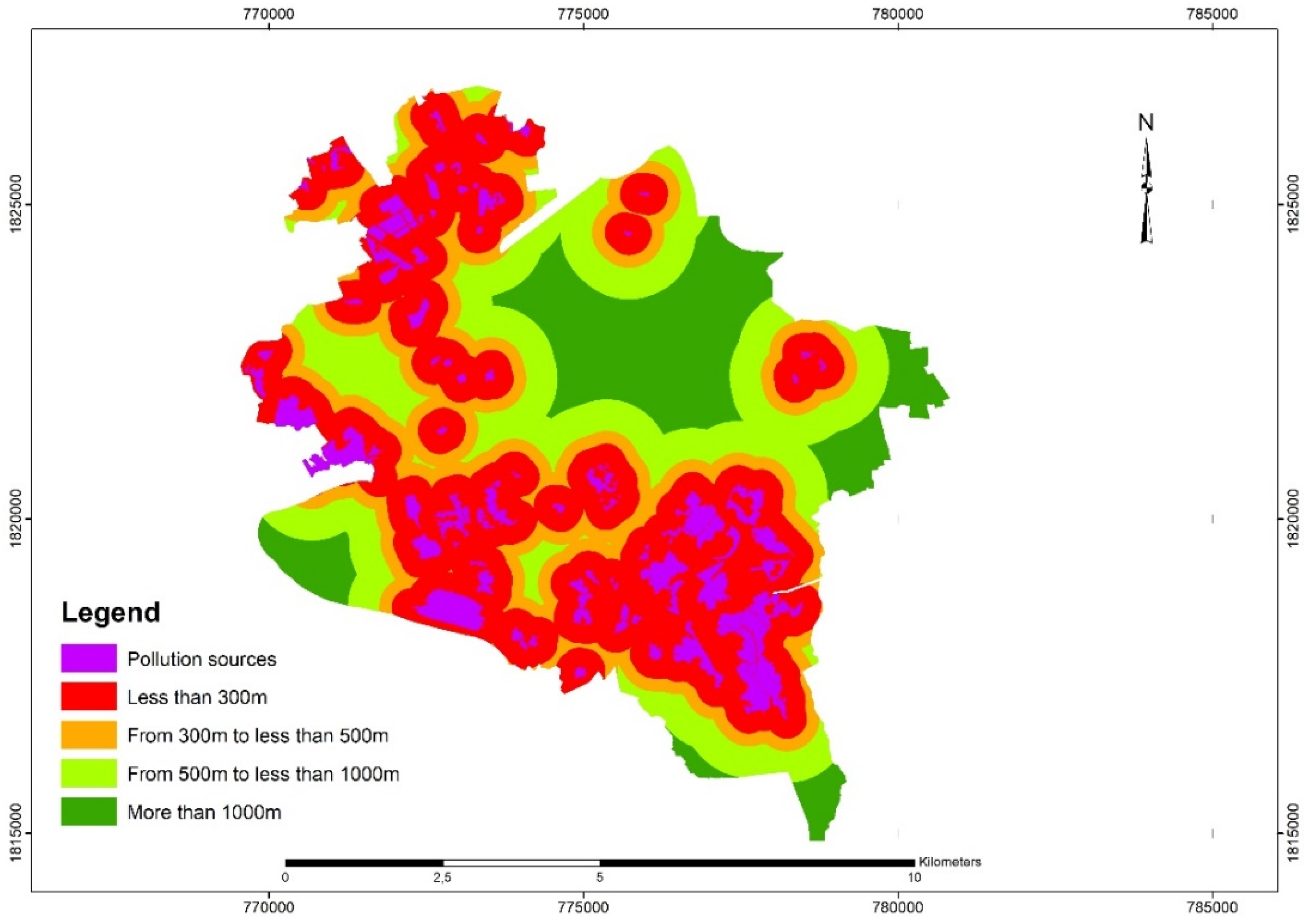
| Distance from pollution sources | <300 m | 0.19 | 1.00 | 2.19 | 3.00 | Land use map in 2020 |
| 300–500 m | 4.00 | 5.34 | 7.00 | |||
| 500–1000 m | 7.00 | 7.59 | 8.00 | |||
| >1000 m | 9.00 | 9.00 | 9.00 | |||
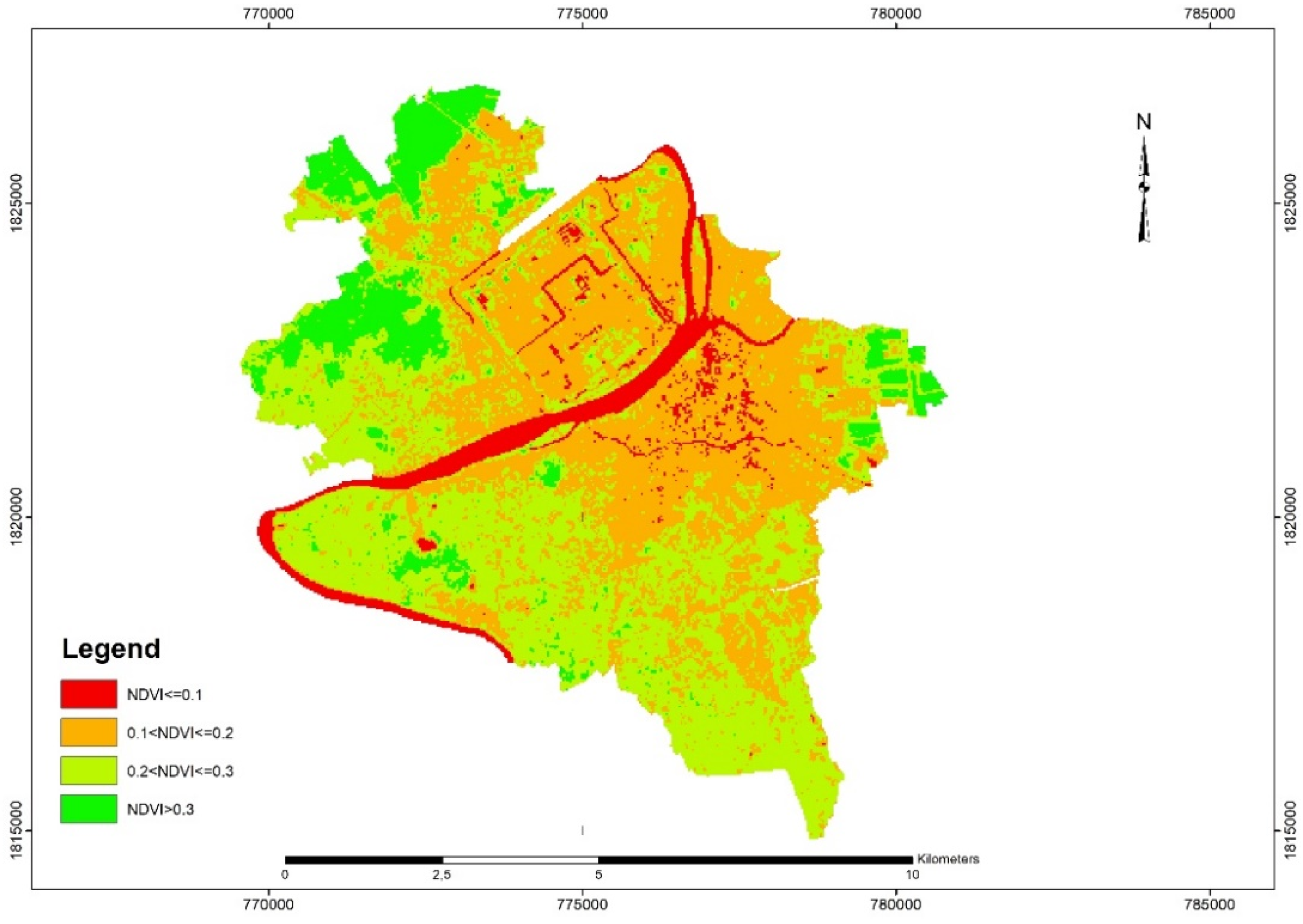
| Normalized Difference Vegetation Index | <0.1 | 0.13 | 1.00 | 1.81 | 2.00 | Landsat 8 OLI |
| [0.1–0.2) | 5.00 | 5.63 | 7.00 | |||
| [0.2–0.3) | 7.00 | 7.57 | 9.00 | |||
| ≥0.3 | 8.00 | 8.89 | 9.00 | |||
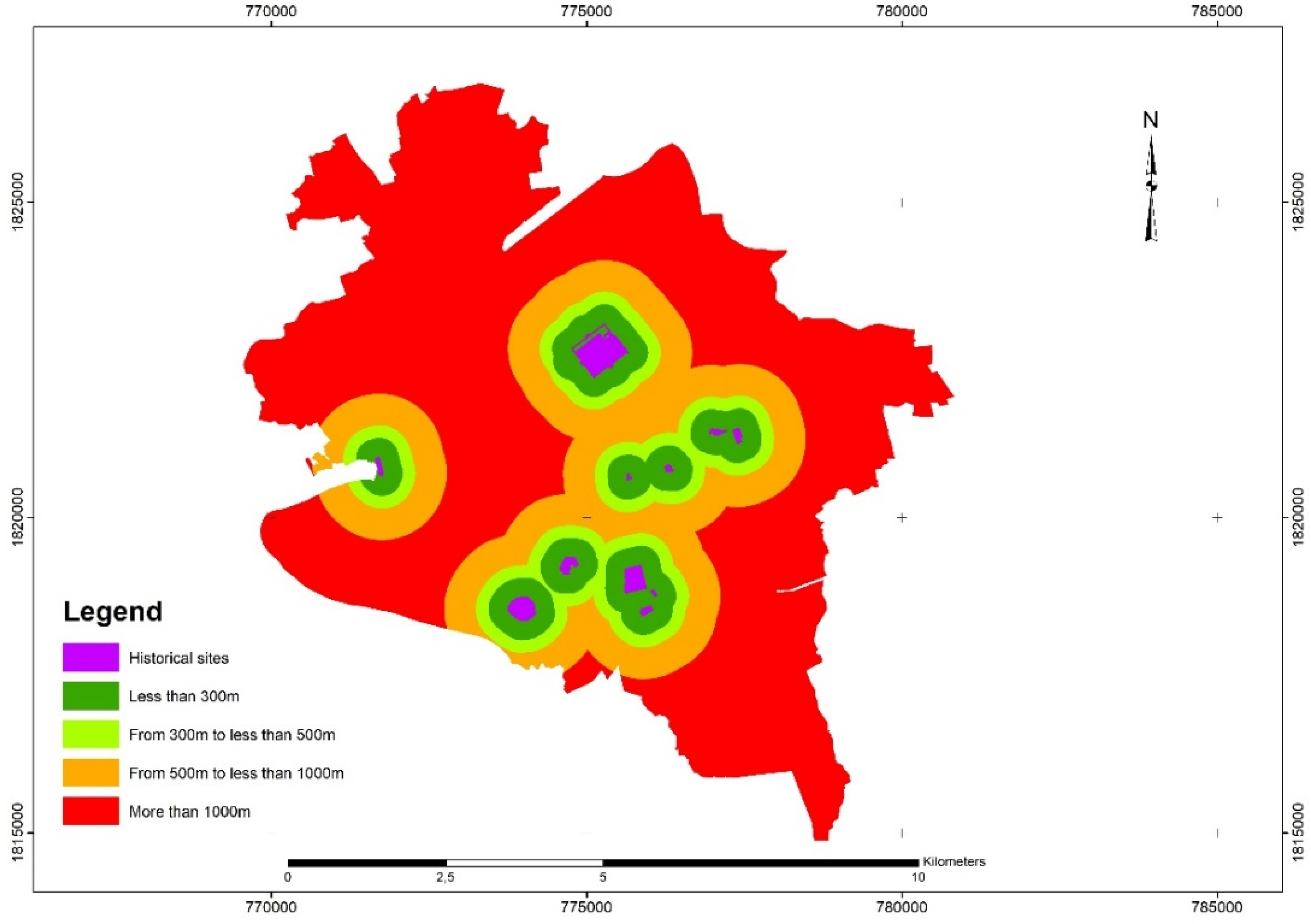
| Distance to historical sites | <300 m | 0.08 | 9.00 | 9.00 | 9.00 | Land use map in 2020 |
| 300–500 m | 8.00 | 8.38 | 9.00 | |||
| 500–1000 m | 6.00 | 6.76 | 7.00 | |||
| >1000 m | 5.00 | 5.86 | 7.00 | |||
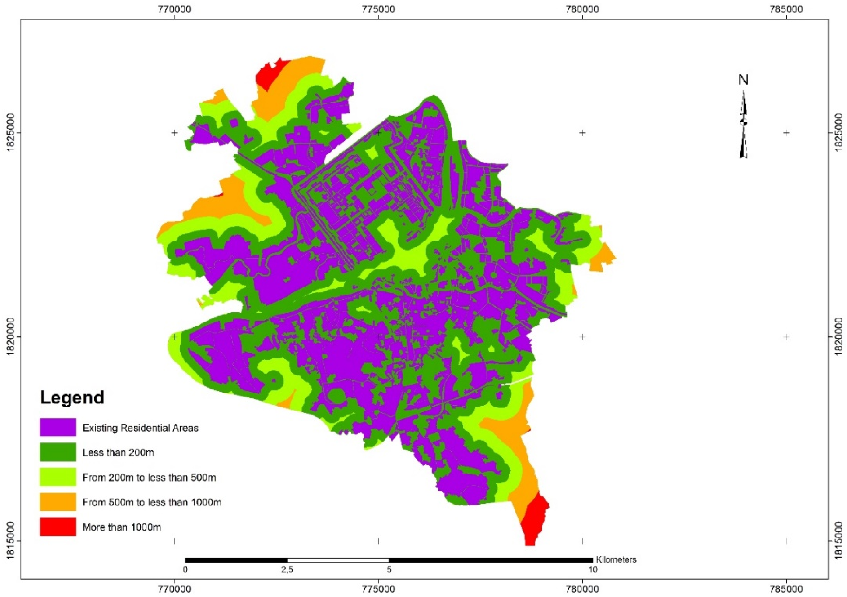
| The distance to residential areas | 200 m | 0.36 | 8.00 | 8.69 | 9.00 | Land use map in 2020 |
| 200–500 m | 7.00 | 8.08 | 9.00 | |||
| 500–1000 m | 5.00 | 6.45 | 7.00 | |||
| >1000 m | 3.00 | 5.03 | 6.00 | |||
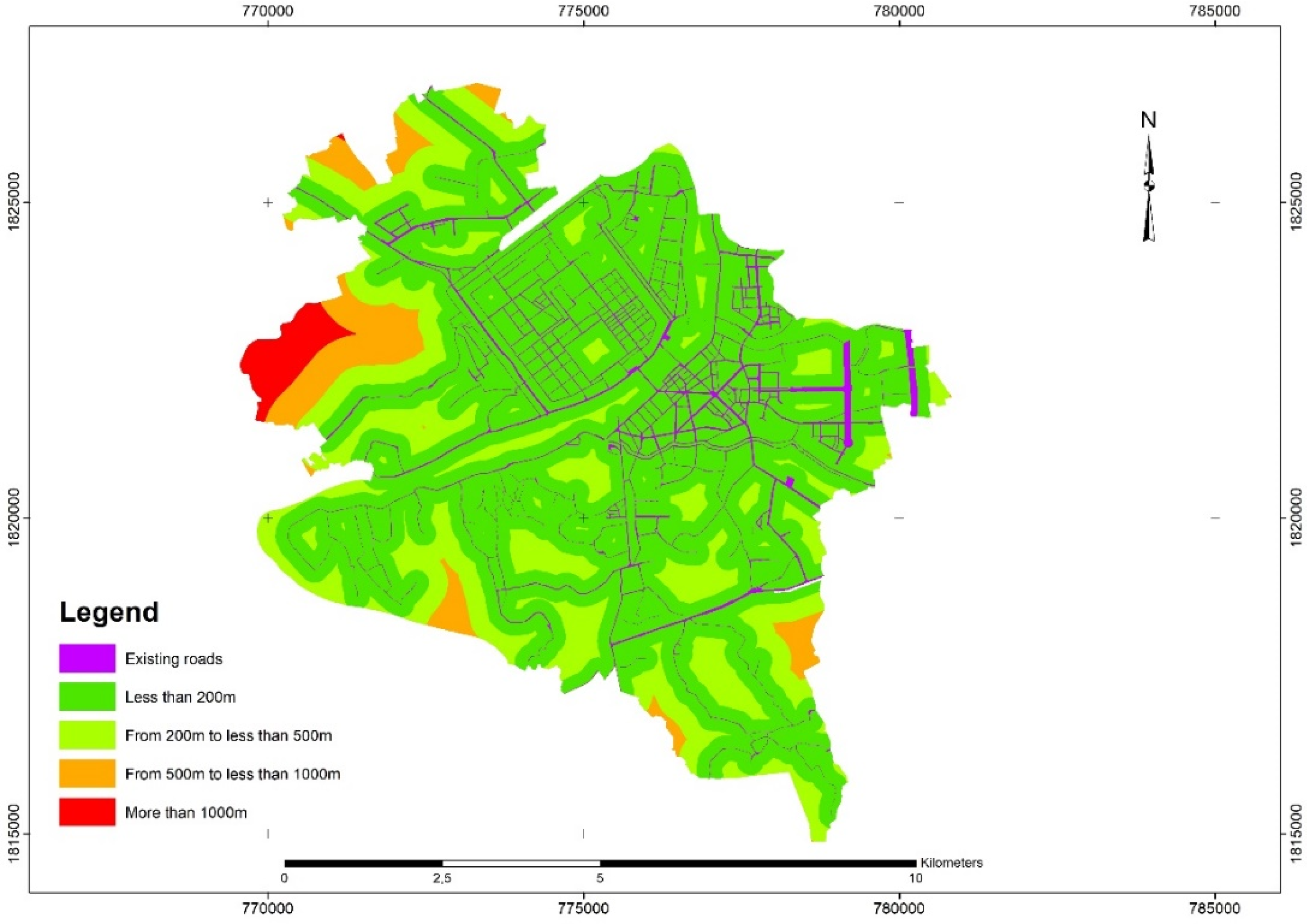
| The distance to main roads | <200 m | 0.17 | 8.00 | 8.48 | 9.00 | Land use map in 2020 |
| 200–500 m | 7.00 | 7.77 | 8.00 | |||
| 500–1000 m | 5.00 | 6.06 | 7.00 | |||
| >1000 m | 3.00 | 3.84 | 6.00 | |||
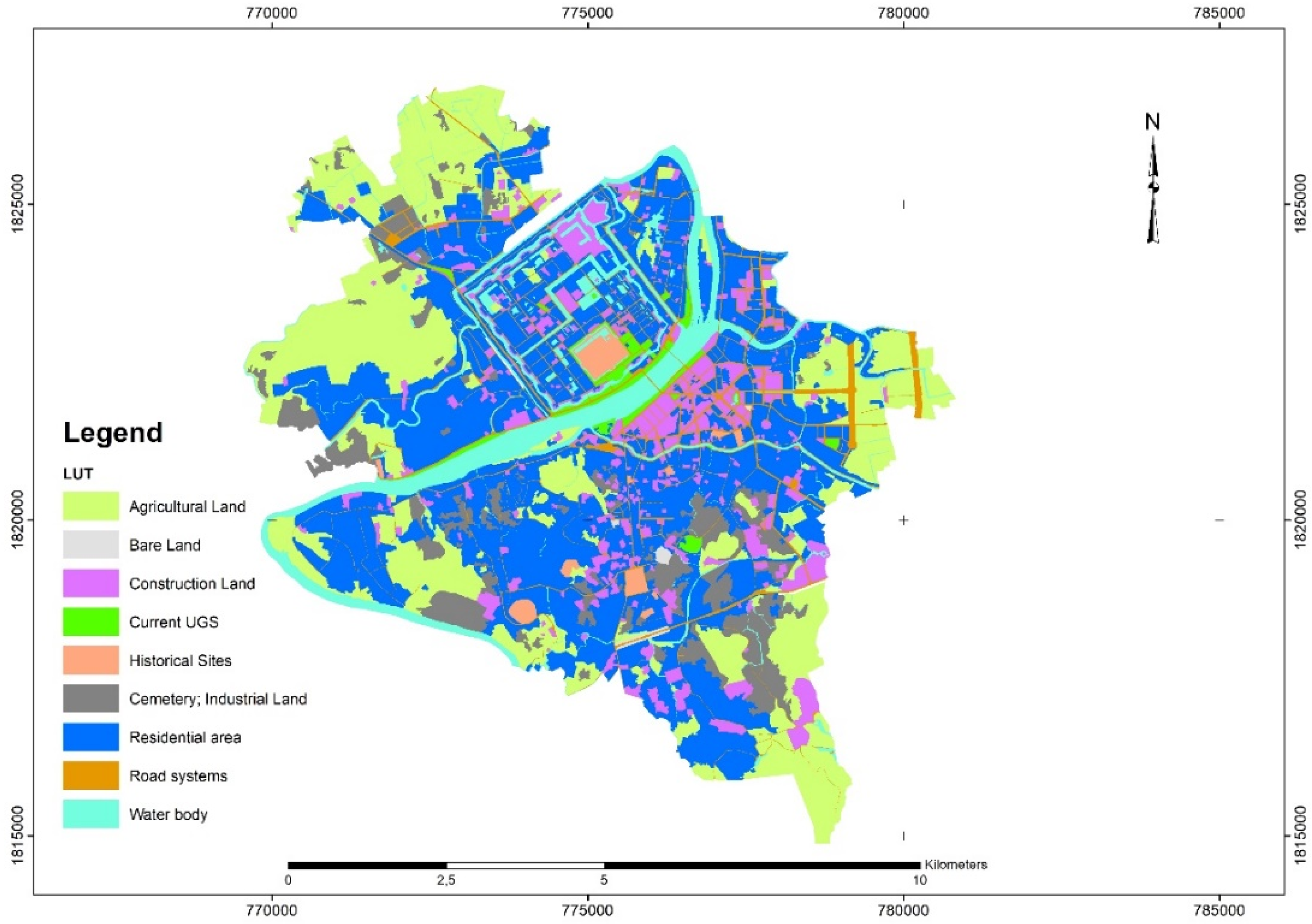
| Current land use types | Agricultural land | 0.07 | 7.00 | 7.97 | 9.00 | Land use map in 2020 |
| Bare land | 6.00 | 7.46 | 8.00 | |||
| Construction land | 1.00 | 1.00 | 1.00 | |||
| Current UGS | 8.00 | 8.69 | 9.00 | |||
| Historical sites | 1.00 | 1.91 | 3.00 | |||
| Cemetery, industrial land | 1.00 | 1.00 | 1.00 | |||
| Residential areas | 1.00 | 1.28 | 2.00 | |||
| Road land | 1.00 | 1.00 | 1.00 | |||
| Waterbody | 1.00 | 1.00 | 1.00 | |||
| Numeric Scales | Response Alternatives of Participants |
|---|---|
| 9 | |
| 7 | |
| 5 | |
| 3 | |
| 1 | |
| 1/3 | |
| 1/5 | |
| 1/7 | is strongly less important than criterion |
| 1/9 | is extremely less important than criterion j |
| n | 1 | 2 | 3 | 4 | 5 | 6 | 7 | 8 | 9 | 10 |
| RI | 0 | 0 | 0.58 | 0.90 | 1.12 | 1.24 | 1.32 | 1.41 | 1.45 | 1.49 |
| Definition | |
|---|---|
| 7–9 | Criterion is suitable for UGS without any concerns. |
| 5–7 | Criterion is suitable for UGS with few concerns. |
| 3–5 | Criterion may be suitable for UGS with many concerns. |
| 1–3 | Criterion is unsuitable for UGS. |
Publisher’s Note: MDPI stays neutral with regard to jurisdictional claims in published maps and institutional affiliations. |
© 2022 by the authors. Licensee MDPI, Basel, Switzerland. This article is an open access article distributed under the terms and conditions of the Creative Commons Attribution (CC BY) license (https://creativecommons.org/licenses/by/4.0/).
Share and Cite
Linh, N.H.K.; Tung, P.G.; Chuong, H.V.; Ngoc, N.B.; Phuong, T.T. The Application of Geographical Information Systems and the Analytic Hierarchy Process in Selecting Sustainable Areas for Urban Green Spaces: A Case Study in Hue City, Vietnam. Climate 2022, 10, 82. https://doi.org/10.3390/cli10060082
Linh NHK, Tung PG, Chuong HV, Ngoc NB, Phuong TT. The Application of Geographical Information Systems and the Analytic Hierarchy Process in Selecting Sustainable Areas for Urban Green Spaces: A Case Study in Hue City, Vietnam. Climate. 2022; 10(6):82. https://doi.org/10.3390/cli10060082
Chicago/Turabian StyleLinh, Nguyen Hoang Khanh, Pham Gia Tung, Huynh Van Chuong, Nguyen Bich Ngoc, and Tran Thi Phuong. 2022. "The Application of Geographical Information Systems and the Analytic Hierarchy Process in Selecting Sustainable Areas for Urban Green Spaces: A Case Study in Hue City, Vietnam" Climate 10, no. 6: 82. https://doi.org/10.3390/cli10060082
APA StyleLinh, N. H. K., Tung, P. G., Chuong, H. V., Ngoc, N. B., & Phuong, T. T. (2022). The Application of Geographical Information Systems and the Analytic Hierarchy Process in Selecting Sustainable Areas for Urban Green Spaces: A Case Study in Hue City, Vietnam. Climate, 10(6), 82. https://doi.org/10.3390/cli10060082