Spatiotemporal Prediction of Increasing Winter Perceived Temperature across a Sub-Tropical City for Sustainable Planning and Climate Change Mitigation


Abstract
1. Introduction
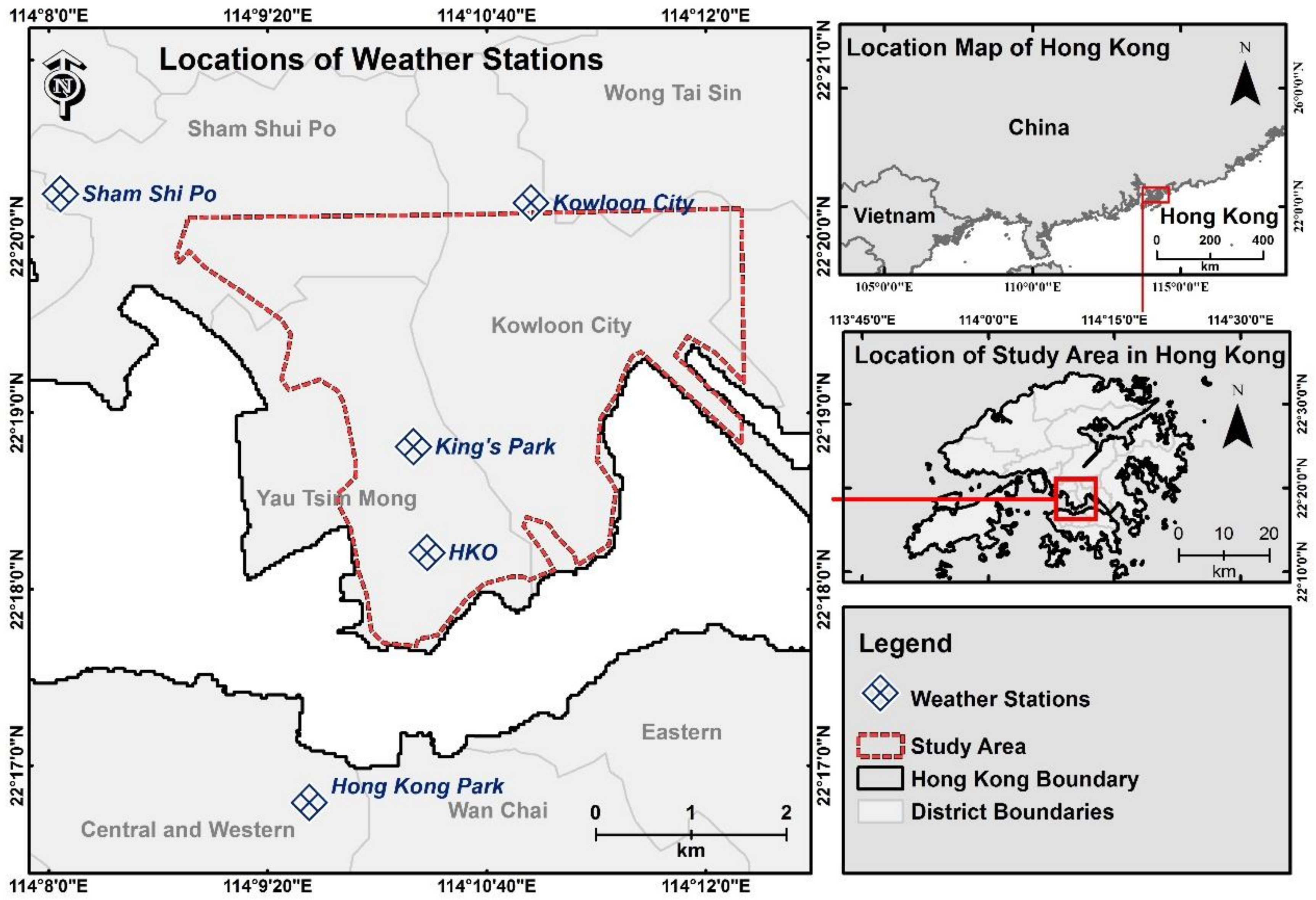
2. Study Area
3. Methods
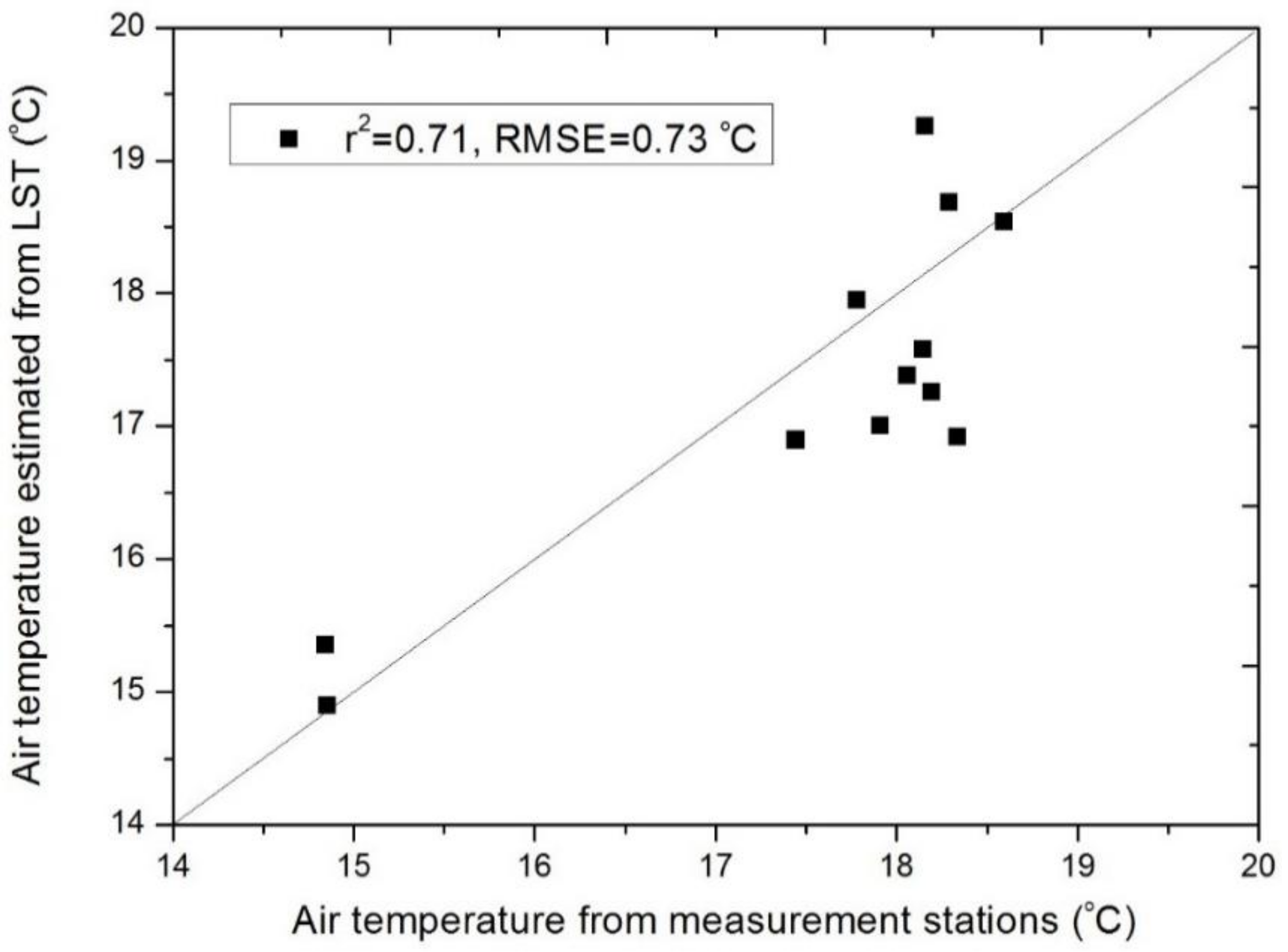
3.1. Data Collection
3.2. Estimation of Adjusted Wind Chill Equivalent Temperature (AWCET)
3.3. Comparative Analyses of Increasing Winter Perceived Temperature and Urban Environment
4. Results
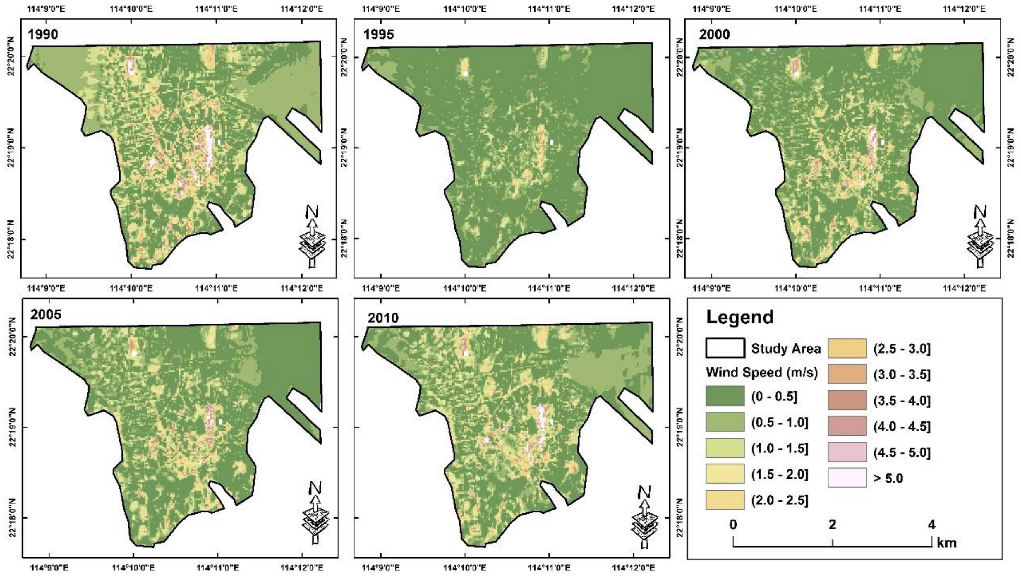
4.1. Spatial Datasets for Adjusted Wind Chill Equivalent Temperature (AWCET) Estimation
4.2. Comparison of Relative AWCET Increase and Urban Environmental Factors
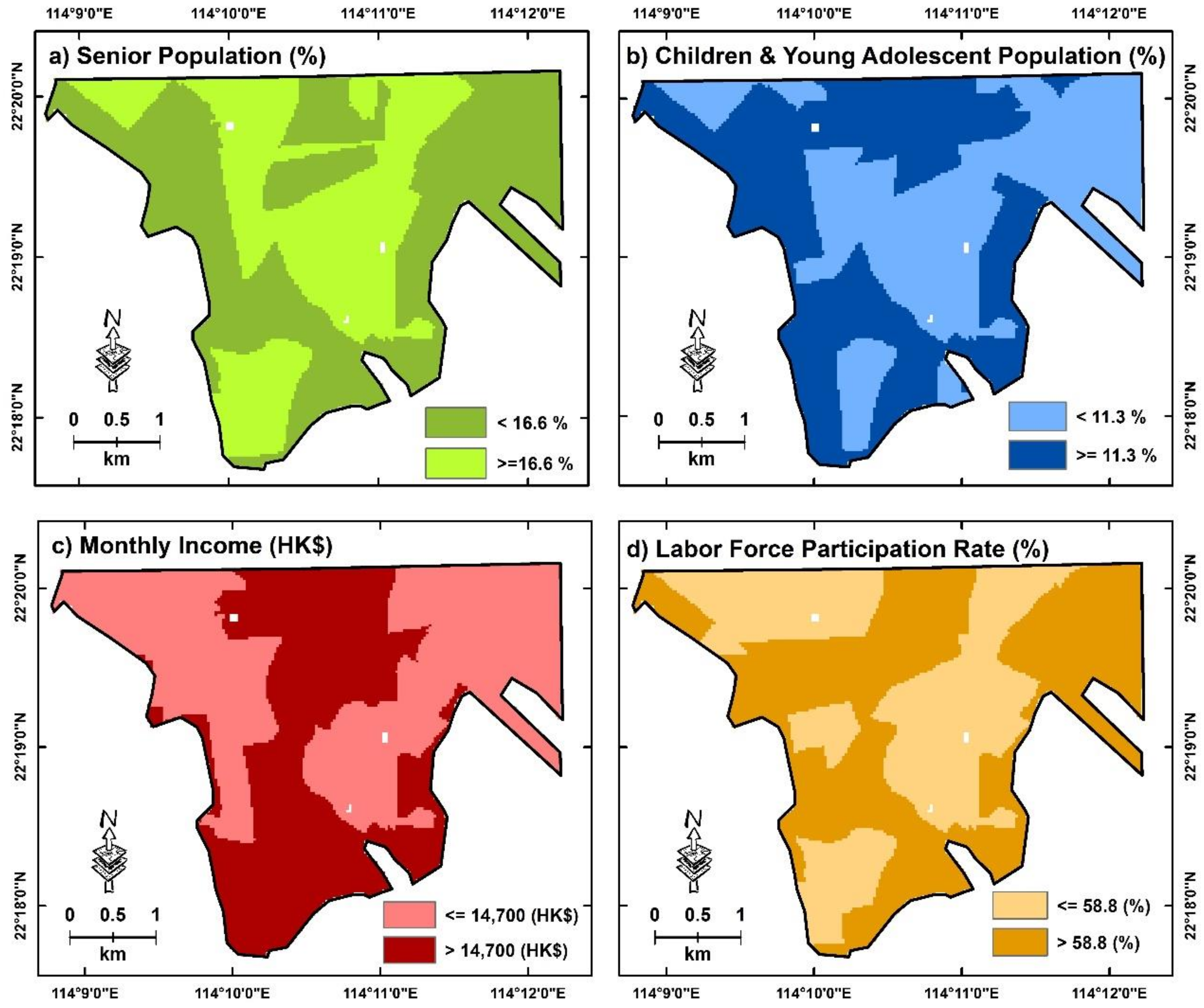
4.3. AWCET Increases and Urban Environments across Socioeconomically Deprived Areas
5. Discussion
5.1. Implications and Guidelines for Sustainable Development
5.2. Limitations and Future Directions
6. Conclusions
Author Contributions
Funding
Acknowledgments
Conflicts of Interest
References
- Lafortezza, R.; Carrus, G.; Sanesi, G.; Davies, C. Benefits and well-being perceived by people visiting green spaces in periods of heat stress. Urban For. Urban Green. 2009, 8, 97–108. [Google Scholar]
- Harlan, S.L.; Brazel, A.J.; Prashad, L.; Stefanov, W.L.; Larsen, L. Neighborhood microclimates and vulnerability to heat stress. Soc. Sci. Med. 2006, 63, 2847–2863. [Google Scholar] [CrossRef] [PubMed]
- Krstic, N.; Yuchi, W.; Ho, H.C.; Walker, B.B.; Knudby, A.J.; Henderson, S.B. The Heat Exposure Integrated Deprivation Index (HEIDI): A data-driven approach to quantifying neighborhood risk during extreme hot weather. Environ. Int. 2017, 109, 42–52. [Google Scholar] [CrossRef] [PubMed]
- Thorsson, S.; Lindberg, F.; Björklund, J.; Holmer, B.; Rayner, D. Potential changes in outdoor thermal comfort conditions in Gothenburg, Sweden due to climate change: the influence of urban geometry. Int. J. Climatol. 2010, 31, 324–335. [Google Scholar] [CrossRef]
- Grigorieva, E.A.; de Freitas, C.R. A comparison and appraisal of a comprehensive range of human thermal climate indices. Int. J. Biometeorol. 2016, 61, 487–512. [Google Scholar]
- Ketterer, C.; Matzarakis, A. Mapping the Physiologically Equivalent Temperature in urban areas using artificial neural network. Landsc. Urban Plan. 2016, 150, 1–9. [Google Scholar] [CrossRef]
- Ho, H.C.; Knudby, A.; Xu, Y.; Hodul, M.; Aminipouri, M. A comparison of urban heat islands mapped using skin temperature, air temperature, and apparent temperature (Humidex), for the greater Vancouver area. Sci. Total Environ. 2016, 544, 929–938. [Google Scholar] [CrossRef]
- Lai, P.-C.; Choi, C.C.; Wong, P.P.; Thach, T.-Q.; Wong, M.S.; Cheng, W.; Krämer, A.; Wong, C.-M. Spatial analytical methods for deriving a historical map of physiological equivalent temperature of Hong Kong. Build. Environ. 2016, 99, 22–28. [Google Scholar] [CrossRef]
- Song, Y.; Wu, C. Examining human heat stress with remote sensing technology. GIScience Remote Sens. 2017, 55, 19–37. [Google Scholar]
- Aminipouri, M.; Knudby, A.; Ho, H.C. Using multiple disparate data sources to map heat vulnerability: Vancouver case study. Can. Geogr. 2016, 60, 356–368. [Google Scholar] [CrossRef]
- Kershaw, S.E.; Millward, A.A. A spatio-temporal index for heat vulnerability assessment. Environ. Monit. Assess 2012, 184, 7329–7342. [Google Scholar] [CrossRef] [PubMed]
- Russo, S.; Sillmann, J.; Fischer, E. Top ten European heatwaves since 1950 and their occurrence in the coming decades. Environ. Res. Lett. 2015, 10, 124003. [Google Scholar] [CrossRef]
- Smith, S.J.; Edmonds, J.; Hartin, C.A.; Mundra, A.; Calvin, K. Near-term acceleration in the rate of temperature change. Nature Clim. Chang. 2015, 5, 333–336. [Google Scholar] [CrossRef]
- Staddon, P.L.; Montgomery, H.E.; Depledge, M.H. Climate warming will not decrease winter mortality. Nature Clim. Chang. 2014, 4, 190–194. [Google Scholar] [CrossRef]
- Carvalho, D.; Martins, H.; Marta-Almeida, M.; Rocha, A.; Borrego, C. Urban resilience to future urban heat waves under a climate change scenario: A case study for Porto urban area (Portugal). Urban Clim. 2017, 19, 1–27. [Google Scholar] [CrossRef]
- Peng, F.; Wong, M.S.; Ho, H.C.; Nichol, J.; Chan, P.W. Reconstruction of historical datasets for analyzing spatiotemporal influence of built environment on urban microclimates across a compact city. Build. Environ. 2017, 123, 649–660. [Google Scholar] [CrossRef]
- Wong, M.S.; Nichol, J.E.; To, P.H.; Wang, J. A simple method for designation of urban ventilation corridors and its application to urban heat island analysis. Build. Environ. 2010, 45, 1880–1889. [Google Scholar] [CrossRef]
- Wong, M.S.; Nichol, J.; Ng, E. A study of the “wall effect” caused by proliferation of high-rise buildings using GIS techniques. Landsc. Urban Plan. 2011, 102, 245–253. [Google Scholar] [CrossRef]
- Wong, M.S.; Nichol, J.E. Spatial variability of frontal area index and its relationship with urban heat island intensity. Int. J. Remote Sens. 2012, 34, 885–896. [Google Scholar] [CrossRef]
- Peng, F.; Wong, M.S.; Wan, Y.; Nichol, J.E. Modeling of urban wind ventilation using high resolution airborne LiDAR data. Comput. Environ. Urban Syst. 2017, 64, 81–90. [Google Scholar] [CrossRef]
- Chan, E.Y.Y.; Goggins, W.B.; Ng, E.; Ren, C.; Chen, L. Effect Modification of the Association between Short-term Meteorological Factors and Mortality by Urban Heat Islands in Hong Kong. PLoS ONE 2012, 7, 38551. [Google Scholar]
- Yan, Y.Y. The influence of weather on human mortality in Hong Kong. Soc. Sci. Med. 2000, 50, 419–427. [Google Scholar] [CrossRef]
- Yang, J.; Wong, M.S.; Menenti, M.; Nichol, J. Study of the geometry effect on land surface temperature retrieval in urban environment. ISPRS J. Photogramm. Remote Sens. 2015, 109, 77–87. [Google Scholar] [CrossRef]
- Osczevski, R.; Bluestein, M. The New Wind Chill Equivalent Temperature Chart. Bull. Amer. Meteor. Soc. 2005, 86, 1453–1458. [Google Scholar] [CrossRef]
- Lin, Y.-K.; Wang, Y.-C.; Lin, P.-L.; Li, M.-H.; Ho, T.-J. Relationships between cold-temperature indices and all causes and cardiopulmonary morbidity and mortality in a subtropical island. Sci. Total Environ. 2013, 461, 627–635. [Google Scholar] [CrossRef] [PubMed]
- Yang, J.; Wong, M.S.; Menenti, M.; Nichol, J.; Voogt, J.; Krayenhoff, E.S.; Chan, P. Development of an improved urban emissivity model based on sky view factor for retrieving effective emissivity and surface temperature over urban areas. ISPRS J. Photogramm. Remote Sens. 2016, 122, 30–40. [Google Scholar] [CrossRef]
- Xu, Y.; Knudby, A.; Ho, H.C. Estimating daily maximum air temperature from MODIS in British Columbia, Canada. Int. J. Remote Sens. 2014, 35, 8108–8121. [Google Scholar] [CrossRef]
- Nichol, J.E.; Fung, W.Y.; Lam, K.-S.; Wong, M.S. Urban heat island diagnosis using ASTER satellite images and ‘in situ’ air temperature. Atmos. Res. 2009, 94, 276–284. [Google Scholar] [CrossRef]
- Uchida, T.; Ohya, Y. Verification of the Prediction Accuracy of Annual Energy Output at Noma Wind Park by the Non-Stationary and Non-Linear Wind Synopsis Simulator, RIAM-COMPACT. JFST 2008, 3, 344–358. [Google Scholar] [CrossRef]
- Uchida, T.; Ohya, Y. Latest Developments in Numerical Wind Synopsis Prediction Using the RIAM-COMPACT® CFD Model—Design Wind Speed Evaluation and Wind Risk (Terrain-Induced Turbulence) Diagnostics in Japan. Energies 2011, 4, 458–474. [Google Scholar] [CrossRef]
- Uchida, T.; Maruyama, T.; Ohya, Y. New Evaluation Technique for WTG Design Wind Speed Using a CFD-Model-Based Unsteady Flow Simulation with Wind Direction Changes. Model. Simul. Eng. 2011, 2011, 1–6. [Google Scholar] [CrossRef]
- Chun, B.; Guldmann, J.-M. Spatial statistical analysis and simulation of the urban heat island in high-density central cities. Landsc. Urban Plan. 2014, 125, 76–88. [Google Scholar] [CrossRef]
- Demuzere, M.; Orru, K.; Heidrich, O.; Olazabal, E.; Geneletti, D.; Orru, H.; Bhave, A.; Mittal, N.; Feliu, E.; Faehnle, M. Mitigating and adapting to climate change: Multi-functional and multi-scale assessment of green urban infrastructure. J. Environ. Manag. 2014, 146, 107–115. [Google Scholar] [CrossRef] [PubMed]
- Matus hodul; Anders knudby; Hung chak ho Estimation of Continuous Urban Sky View Factor from Landsat Data Using Shadow Detection. Remote Sens. 2016, 8, 568. [CrossRef]
- Liang, J.; Gong, J.; Sun, J.; Zhou, J.; Li, W.; Li, Y.; Liu, J.; Shen, S. Automatic Sky View Factor Estimation from Street View Photographs—A Big Data Approach. Remote Sens. 2017, 9, 411. [Google Scholar] [CrossRef]
- Czajkowski, K.; Goward, S.; Stadler, S.; Walz, A. Thermal Remote Sensing of Near Surface Environmental Variables: Application Over the Oklahoma Mesonet. Prof. Geogr. 2000, 52, 345–357. [Google Scholar] [CrossRef]
- Xu, Y.; Liu, Y. Monitoring the Near-surface Urban Heat Island in Beijing, China by Satellite Remote Sensing. Geogr. Res. 2014, 53, 16–25. [Google Scholar] [CrossRef]
- Doulos, L.; Santamouris, M.; Livada, I. Passive cooling of outdoor urban spaces. The role of materials. Sol. Energy 2004, 77, 231–249. [Google Scholar] [CrossRef]
- Crutzen, P.J. New Directions: The growing urban heat and pollution “island” effect—Impact on chemistry and climate ☆. Atm. Environ. 2004, 38, 3539–3540. [Google Scholar] [CrossRef]
- Goodchild, M.F. Citizens as sensors: the world of volunteered geography. GeoJournal 2007, 69, 211–221. [Google Scholar] [CrossRef]
- Godschalk, D.R. Urban Hazard Mitigation: Creating Resilient Cities. Nat. Hazards Rev. 2003, 4, 136–143. [Google Scholar] [CrossRef]
- Cheung, P.K.; Jim, C. Comparing the cooling effects of a tree and a concrete shelter using PET and UTCI. Build. Environ. 2018, 130, 49–61. [Google Scholar] [CrossRef]


| Retrieved Dates of Landsat Images for Data Training of Air Temperature Prediction | ||
|---|---|---|
| 3 March 2011 | 2 February 2011 | 1 January 2011 |
| 29 October 2010 | 30 November 2010 | 18 September 2010 |
| 26 March 2010 | 14 January 2010 | 4 December 2009 |
| 3 February 2009 | 18 January 2009 | 2 January 2009 |
| 1 December 2008 | 17 December 2008 | 4 March 2008 |
| 29 January 2007 | 13 January 2007 | 28 December 2006 |
| Retrieved Dates of Landsat Images for Predicting Air Temperature at the Representative Dates (Same as the Retrieved Date) | ||||
|---|---|---|---|---|
| 24 December 1990 | 30 December 1995 | 11 February 2000 | 23 January 2005 | 23 December 2010 |
| Urban Environmental Factor | Radius for Spatial Averaging | Average Increase in Relative AWCET for Every 5 Years (1990–2010) | ||
|---|---|---|---|---|
| Mean (SD) of Areas with Increase | Mean (SD) of Areas without Increase | p-Values | ||
| Percentage of Vegetation coverage | 100 m | 11.4% (16.0%) | 13.2% (19.9%) | <0.05 |
| 200 m | 12.1% (13.4%) | 13.1% (15.6%) | <0.05 | |
| 300 m | 12.3% (11.6%) | 13.1% (12.6%) | <0.05 | |
| 400 m | 12.5% (10.2%) | 13.1% (10.7%) | <0.05 | |
| 500 m | 12.6% (9.3%) | 13.3% (9.3%) | <0.05 | |
| Percentage of Public Open Space | 100 m | 9.0% (19.0%) | 8.7% (17.0%) | 0.34 |
| 200 m | 8.6% (13.7%) | 8.9% (12.1%) | 0.19 | |
| 300 m | 8.3% (10.4%) | 9.1% (9.2%) | <0.05 | |
| 400 m | 8.2% (8.1%) | 9.0% (7.4%) | <0.05 | |
| 500 m | 8.1% (6.5%) | 9.0% (6.3%) | <0.05 | |
| Percentage of Road Network | 100 m | 23.4% (16.6%) | 26.7% (16.4%) | <0.05 |
| 200 m | 23.1% (12.9%) | 26.3% (13.3%) | <0.05 | |
| 300 m | 22.9% (11.3%) | 25.8% (11.7%) | <0.05 | |
| 400 m | 22.8% (10.2%) | 25.4% (10.5%) | <0.05 | |
| 500 m | 22.7% (9.2%) | 25.0% (9.4%) | <0.05 | |
| Average Sky View Factor | 100 m | 0.70 (0.14) | 0.63 (0.13) | <0.05 |
| 200 m | 0.69 (0.13) | 0.64 (0.12) | <0.05 | |
| 300 m | 0.69 (0.12) | 0.64 (0.11) | <0.05 | |
| 400 m | 0.68 (0.11) | 0.65 (0.10) | <0.05 | |
| 500 m | 0.68 (0.10) | 0.65 (0.10) | <0.05 | |
| Socioeconomic Deprived Areas | Urban Environmental Factor | Radius for Spatial Averaging | Average Increase in Relative AWCET for Every 5 Years (1990–2010) | ||
|---|---|---|---|---|---|
| Mean (SD) of Areas with Increase | Mean (SD) of Areas without Increase | p-Values | |||
| Areas with higher percentage of senior population (age >= 65) | Percentage of Vegetation coverage | 100 m | 17.1% (18.4%) | 19.7% (23.8%) | <0.05 |
| 200 m | 18.7% (14.6%) | 19.1% (17.6%) | 0.32 | ||
| 300 m | 19.3% (12.1%) | 18.9 (13.4%) | 0.17 | ||
| 400 m | 19.4% (9.9%) | 18.7% (10.6%) | <0.05 | ||
| 500 m | 19.1% (8.5%) | 18.5% (8.7%) | <0.05 | ||
| Percentage of Public Open Space | 100 m | 15.0% (25.8%) | 13.1% (22.0%) | <0.05 | |
| 200 m | 14.4% (18.3%) | 12.5% (15.0%) | <0.05 | ||
| 300 m | 13.6% (13.0%) | 12.2% (10.6%) | <0.05 | ||
| 400 m | 12.5% (9.4%) | 11.9% (8.1%) | <0.05 | ||
| 500 m | 11.7% (7.1%) | 11.5% (6.7%) | 0.35 | ||
| Percentage of Road Network | 100 m | 24.0% (13.7%) | 25.3% (13.9%) | <0.05 | |
| 200 m | 23.7% (10.1%) | 25.0% (10.5%) | <0.05 | ||
| 300 m | 23.4% (8.4%) | 24.7% (8.4%) | <0.05 | ||
| 400 m | 23.5% (7.3%) | 24.5% (6.9%) | <0.05 | ||
| 500 m | 23.6% (6.5%) | 24.3% (5.9%) | <0.05 | ||
| Average Sky View Factor | 100 m | 0.64 (0.11) | 0.61 (0.10) | <0.05 | |
| 200 m | 0.64 (0.09) | 0.62 (0.09) | <0.05 | ||
| 300 m | 0.65 (0.08) | 0.02 (0.08) | <0.05 | ||
| 400 m | 0.64 (0.07) | 0.63 (0.07) | <0.05 | ||
| 500 m | 0.64 (0.06) | 0.63 (0.06) | <0.05 | ||
| Areas with higher percentage of children and young adolescent populations (age <= 14) | Percentage of Vegetation coverage | 100 m | 12.8% (16.5%) | 13.3% (21.1%) | 0.22 |
| 200 m | 13.3% (14.1%) | 12.9% (16.7%) | 0.33 | ||
| 300 m | 13.4% (12.2%) | 12.8% (13.4%) | <0.05 | ||
| 400 m | 13.6% (10.5%) | 12.7% (11.1%) | <0.05 | ||
| 500 m | 13.8% (9.4%) | 12.8% (9.5%) | <0.05 | ||
| Percentage of Public Open Space | 100 m | 13.8% (23.2%) | 10.6% (19.3%) | <0.05 | |
| 200 m | 12.4% (16.8%) | 10.8% (14.1%) | <0.05 | ||
| 300 m | 11.2% (12.1%) | 10.9% (10.5%) | 0.42 | ||
| 400 m | 10.5% (9.0%) | 10.8% (8.0%) | 0.27 | ||
| 500 m | 10.1% (6.8%) | 10.5% (6.4%) | <0.05 | ||
| Percentage of Road Network | 100 m | 27.7% (15.3%) | 30.4% (15.6%) | <0.05 | |
| 200 m | 27.0% (11.2%) | 29.7% (12.6%) | <0.05 | ||
| 300 m | 26.6% (10.0%) | 29.0% (11.1%) | <0.05 | ||
| 400 m | 26.1% (9.1%) | 28.2% (10.0%) | <0.05 | ||
| 500 m | 25.6% (8.4%) | 27.3% (9.1%) | <0.05 | ||
| Average Sky View Factor | 100 m | 0.66 (0.10) | 0.61 (0.10) | <0.05 | |
| 200 m | 0.65 (0.09) | 0.62 (0.09) | <0.05 | ||
| 300 m | 0.65 (0.08) | 0.63 (0.08) | <0.05 | ||
| 400 m | 0.65 (0.08) | 0.63 (0.08) | <0.05 | ||
| 500 m | 0.66 (0.07) | 0.64 (0.08) | <0.05 | ||
| Areas with lower median monthly income from main employment of working population excluding unpaid family workers | Percentage of Vegetation coverage | 100 m | 5.8% (9.6%) | 9.8% (17.6%) | <0.05 |
| 200 m | 7.1% (9.2%) | 9.8% (13.7%) | <0.05 | ||
| 300 m | 7.9% (9.0%) | 10.2% (11.3%) | <0.05 | ||
| 400 m | 8.5% (8.6%) | 10.7% (9.9%) | <0.05 | ||
| 500 m | 9.1% (8.1%) | 11.2% (8.9%) | <0.05 | ||
| Percentage of Public Open Space | 100 m | 3.5% (9.7%) | 7.0% (14.9%) | <0.05 | |
| 200 m | 4.2% (7.7%) | 7.2% (10.0%) | <0.05 | ||
| 300 m | 5.0% (7.2%) | 7.3% (7.4%) | <0.05 | ||
| 400 m | 5.6% (6.3%) | 7.5% (6.3%) | <0.05 | ||
| 500 m | 6.1% (5.6%) | 7.6% (5.7%) | <0.05 | ||
| Percentage of Road Network | 100 m | 24.4% (18.4%) | 28.8% (17.9%) | <0.05 | |
| 200 m | 23.8% (15.5%) | 28.5% (15.4%) | <0.05 | ||
| 300 m | 23.4% (14.0%) | 28.0% (13.8%) | <0.05 | ||
| 400 m | 23.1% (12.7%) | 27.4% (12.5%) | <0.05 | ||
| 500 m | 23.0% (11.4%) | 26.7% (11.3%) | <0.05 | ||
| Average Sky View Factor | 100 m | 0.72 (0.16) | 0.64 (0.15) | <0.05 | |
| 200 m | 0.72 (0.15) | 0.65 (0.14) | <0.05 | ||
| 300 m | 0.71 (0.14) | 0.65 (0.13) | <0.05 | ||
| 400 m | 0.71 (0.13) | 0.66 (0.12) | <0.05 | ||
| 500 m | 0.70 (0.12) | 0.66 (0.12) | <0.05 | ||
| Areas with lower percentage of labor force participation rate | Percentage of Vegetation coverage | 100 m | 13.5% (15.7%) | 17.3% (23.3%) | <0.05 |
| 200 m | 15.3% (13.0%) | 16.7% (17.6%) | <0.05 | ||
| 300 m | 16.3% (11.4%) | 16.5% (13.6%) | 0.62 | ||
| 400 m | 16.8% (9.9%) | 16.4% (10.9%) | 0.13 | ||
| 500 m | 16.8% (8.8%) | 16.3% (9.0%) | <0.05 | ||
| Percentage of Public Open Space | 100 m | 10.0% (18.1%) | 12.0% (20.6%) | <0.05 | |
| 200 m | 10.4% (12.1%) | 11.6% (13.8%) | <0.05 | ||
| 300 m | 10.6% (9.1%) | 11.2% (9.6%) | <0.05 | ||
| 400 m | 10.5% (7.2%) | 10.9% (7.2%) | <0.05 | ||
| 500 m | 10.3% (5.8%) | 10.7% (6.0%) | <0.05 | ||
| Percentage of Road Network | 100 m | 26.8% (13.9%) | 27.8% (14.8%) | <0.05 | |
| 200 m | 26.2% (10.6%) | 27.5% (11.5%) | <0.05 | ||
| 300 m | 25.8% (9.3%) | 26.9% (9.6%) | <0.05 | ||
| 400 m | 25.5% (8.2%) | 26.5% (8.2%) | <0.05 | ||
| 500 m | 25.3% (7.3%) | 25.9% (7.1%) | <0.05 | ||
| Average Sky View Factor | 100 m | 0.63 (0.10) | 0.61 (0.10) | <0.05 | |
| 200 m | 0.63 (0.09) | 0.61 (0.08) | <0.05 | ||
| 300 m | 0.63 (0.07) | 0.62 (0.07) | <0.05 | ||
| 400 m | 0.63 (0.06) | 0.62 (0.07) | <0.05 | ||
| 500 m | 0.63 (0.06) | 0.63 (0.06) | 0.51 | ||
© 2019 by the authors. Licensee MDPI, Basel, Switzerland. This article is an open access article distributed under the terms and conditions of the Creative Commons Attribution (CC BY) license (http://creativecommons.org/licenses/by/4.0/).
Share and Cite
Ho, H.C.; Abbas, S.; Yang, J.; Zhu, R.; Wong, M.S. Spatiotemporal Prediction of Increasing Winter Perceived Temperature across a Sub-Tropical City for Sustainable Planning and Climate Change Mitigation. Int. J. Environ. Res. Public Health 2019, 16, 497. https://doi.org/10.3390/ijerph16030497
Ho HC, Abbas S, Yang J, Zhu R, Wong MS. Spatiotemporal Prediction of Increasing Winter Perceived Temperature across a Sub-Tropical City for Sustainable Planning and Climate Change Mitigation. International Journal of Environmental Research and Public Health. 2019; 16(3):497. https://doi.org/10.3390/ijerph16030497
Chicago/Turabian StyleHo, Hung Chak, Sawaid Abbas, Jinxin Yang, Rui Zhu, and Man Sing Wong. 2019. "Spatiotemporal Prediction of Increasing Winter Perceived Temperature across a Sub-Tropical City for Sustainable Planning and Climate Change Mitigation" International Journal of Environmental Research and Public Health 16, no. 3: 497. https://doi.org/10.3390/ijerph16030497
APA StyleHo, H. C., Abbas, S., Yang, J., Zhu, R., & Wong, M. S. (2019). Spatiotemporal Prediction of Increasing Winter Perceived Temperature across a Sub-Tropical City for Sustainable Planning and Climate Change Mitigation. International Journal of Environmental Research and Public Health, 16(3), 497. https://doi.org/10.3390/ijerph16030497