Integrating Remote Sensing Information Into A Distributed Hydrological Model for Improving Water Budget Predictions in Large-scale Basins through Data Assimilation

Abstract
:1. Introduction
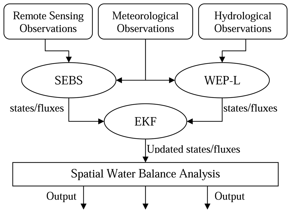
2. A data assimilation system for water budget predictions
2.1 Overview
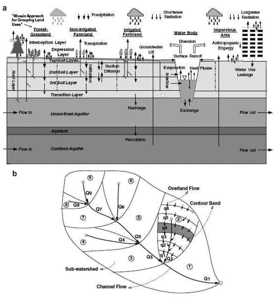
2.2 Description of the WEP-L model
2.3 Description of the SEBS algorithm
2.4 The extended Kalman filter
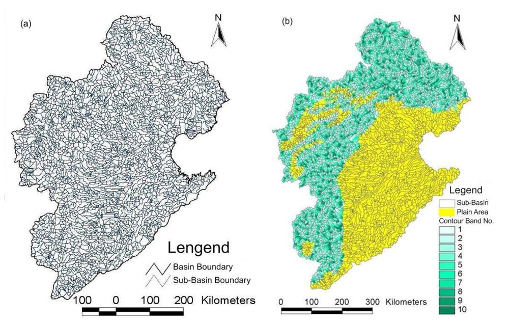
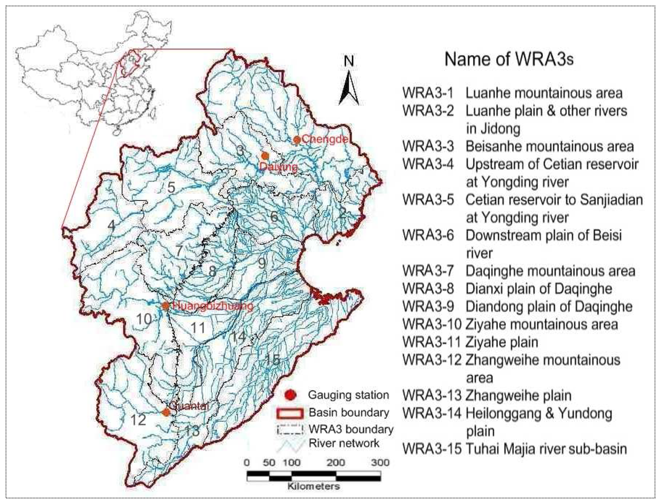
3. Description of study area
4. Data preparation and assimilation results, discussion
4.1 WEP-L application to the Haihe basin
Model parameterization and sensitivity analysis
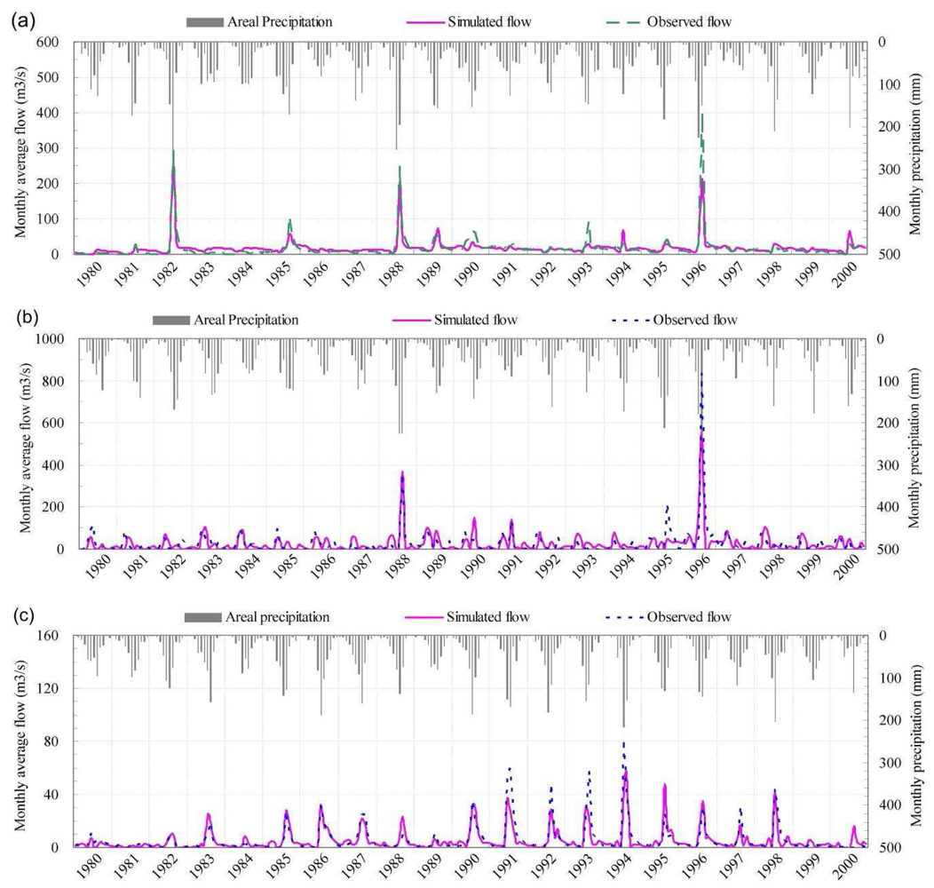
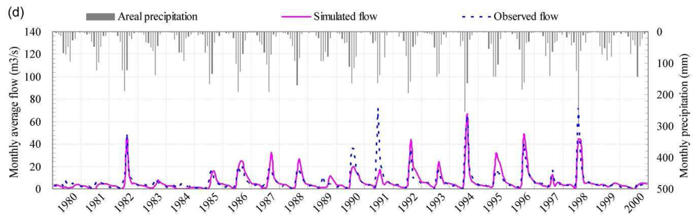
Model calibration and validation
4.2 SEBS application to the Haihe basin
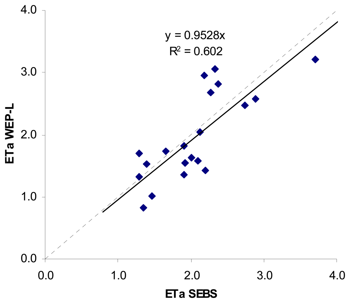
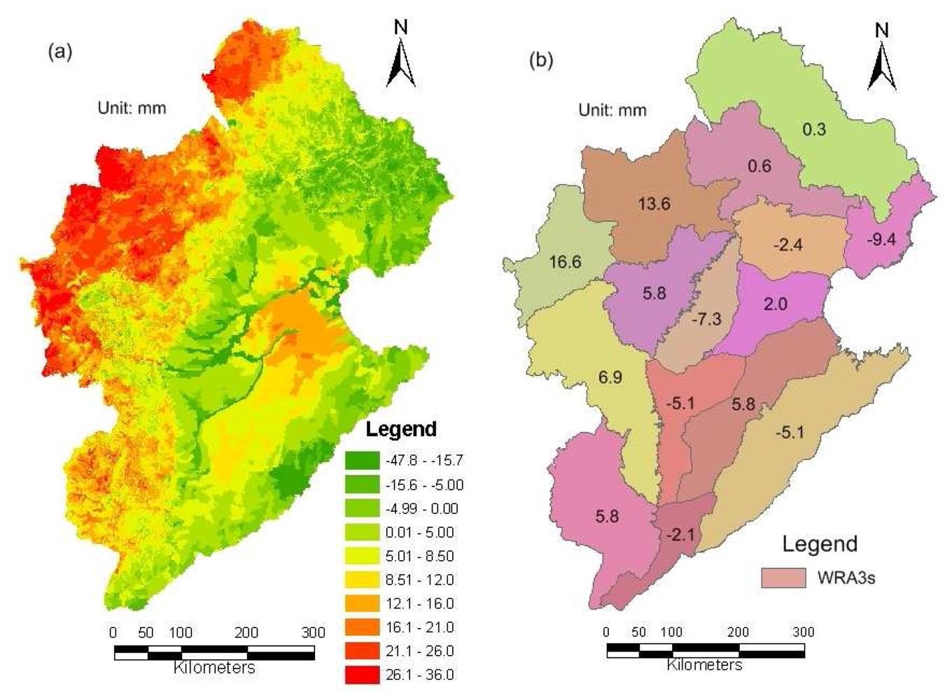
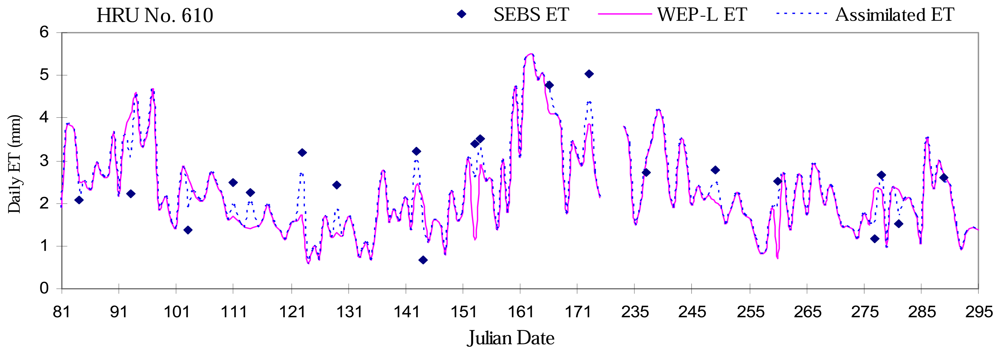
4.3 Results and discussion of DA
5. Conclusion and remarks
Acknowledgments
References and Notes
- Maurer, E.P.; O'Donnell, G.M.; Lettenmaier, D.P.; Roads, J.O. Evaluation of the land surface water budget in NCEP/NCAR and NCEP/DOE reanalysis using an off-line hydrologic model. Journal of Geophysical Research 2001, 106(D16), 17841–17862. [Google Scholar]
- Roads, J.; Lawford, R.; Bainto, E.; Berbery, E.; Chen, S.; Fekete, B. Evaluation of the North American Land Data Assimilation System over the southern Great Plains during the warm season. Journal of Geophysical Research 2003, 108, D22. [Google Scholar]
- Pan, M.; Wood, E.F.; Wójcik, R.; McCabe, M.F. Estimation of regional terrestrial water cycle using multi-sensor remote sensing observations and data assimilation. Remote Sensing of Environment 2007. [Google Scholar] [CrossRef]
- McLaughlin, D.B. Recent developments in hydrologic data assimilation. In Rev. Geohpys.; 1995; Volume 33, (suppl.), American Geophysical Union. [Google Scholar]
- McLaughlin, D.B. An integrated approach to hydrologic data assimilation: Interpoliation, smoothing, and filtering. Advances in Water Resources 2002, 25, 1275–1286. [Google Scholar]
- Callies, U.; Rhodin, A.; Eppel, D.P. A case study on variational soil moisture analysis from atmospheric observations. Journal of Hydrology 1998, 212-213, 95–108. [Google Scholar]
- Houser, P.R.; Shuttleworth, W.J.; Famiglietti, J.S.; Gupta, H.V.; Syed, K.H.; Goodrich, D.C. Integration of soil moisture remote sensing and hydrologic modeling using data assimilation. Water Resource Research 1998, 34(12), 3405–3420. [Google Scholar]
- Galantowicz, J.F.; Entekhabi, D.; Njoku, E.G. Test of sequential data assimilation for retrieving profile soil moisture and temperature from observed L-band radiobrightness. IEEE Trans. Geosci. Remote Sensing 1999, 37(4), 1860–1870. [Google Scholar]
- Wigneron, J.P.; Olioso, A.; Calvet, J.C.; Bertuzzi, P. Estimating root zone soil moisture from surface soil moisture data and soil–vegetation–atmosphere transfer modeling. Water Resource Research 1999, 35(12), 3735–3745. [Google Scholar]
- Hoeben, R.; Troch, P.A. Assimilation of active microwave observation data for soil moisture profile estimation. Water Resource Research 2000, 36(10), 2805–2819. [Google Scholar]
- Lakshmi, V. A simple surface temperature assimilation scheme for use in land surface models. Water Resource Research 2000, 36(12), 3687–3700. [Google Scholar]
- Reichle, R.; Entekhabi, D.; McLaughlin, D.B. Downscaling of radio brightness measurements for soil moisture estimation: A fourdimensional variational data assimilation approach. Water Resource Research 2001, 37(9), 2353–2364. [Google Scholar]
- Reichle, R.; McLaughlin, D.B.; Entekhabi, D. Variational data assimilation of microwave radiobrightness observations for land surface hydrology applications. IEEE Trans. Geosci. Remote Sensing 2001, 39(8), 1708–1718. [Google Scholar]
- Reichle, R.; McLaughlin, D.B.; Entekhabi, D. Hydrologic data assimilation with the Ensemble Kalman filter. Monthly Weather Review 2002, 130(1), 103–114. [Google Scholar]
- Boni, G.; Entekhabi, D.; Castelli, F. Land data assimilation with satellite measurements for the estimation of surface energy balance components and surface control on evaporation. Water Resource Research 2001, 37(6), 1713–1722. [Google Scholar]
- Walker, J.P.; Willgoose, G.R.; Kalma, J.D. One-dimensional soil moisture profile retrieval by assimilation of near-surface measurements: a simplified soil moisture model and field application. J. Hydrometeorol 2001, 2(4), 356–373. [Google Scholar]
- Walker, J.P.; Willgoose, G.R.; Kalma, J.D. One-dimensional soil moisture profile retrieval by assimilation of near-surface observations: a comparison of retrieval algorithms. Adv Water Resour 2001, 24(6), 631–650. [Google Scholar]
- Walker, J.P.; Houser, P.R. A methodology for initializing soil moisture in a global climate model: assimilation of near-surface soil moisture observations. J. Geophys Res––Atmos 2001, 106(D11), 11761–74. [Google Scholar]
- Van Loon, E.E.; Troch, P.A. Tikhonov regularization as a tool for assimilating soil moisture data in distributed hydrological models. Hydrol. Process. 2002, 16(2), 531–556. [Google Scholar]
- Crow, W.T.; Kustas, W.P.; Prueger, J.H. Monitoring root-zone soil moisture through the assimilation of a thermal remote sensing-based soil moisture proxy into a water balance model. Remote Sensing of Environment 2008, 112, 1268–1281. [Google Scholar]
- Das, N.N.; Mohanty, B.P.; Cosh, M.H.; Jackson, T.J. Modeling and assimilation of root zone soil moisture using remote sensing observations in Walnut Gulch Watershed during SMEX04. Remote Sensing of Environment 2008, 112, 415–429. [Google Scholar]
- Kumar, S.V.; Rolf, R.H.; Peters-Lidard, C.D.; Koster, R.D.; Zhan, X.; Crow, W.T.; Eylander, J.B.; Houser, P.R. A land surface data assimilation framework using the land information system: Description and applications. Advances in Water Resources 2008. [Google Scholar] [CrossRef]
- Schuurmans, J.M.; Troch, P.A.; Veldhuizen, A.A.; Bastiaanssen, W.G.M.; Bierkens, M.F.P. Assimilation of remotely sensed latent heat flux in a distributed hydrological model. Advances in Water Resources 2003, 26, 151–159. [Google Scholar]
- Arulampalam, M. S.; Maskell, S.; Gordon, N.; Clapp, T. A tutorial on particle filters for online nonlinear/non-Gaussian Bayesian tracking. IEEE Transactions on Signal Processing 2002, 50(2), 174–188. [Google Scholar]
- Kitagawa, G. Monte Carlo filter and smoother for non-Gaussian nonlinear state space models. Journal of Computational and Graphical Statistics 1996, 5(1), 1–25. [Google Scholar]
- Burgers, G.; van Leeuwen, P. J.; Evensen, G. Analysis scheme in the ensemble Kalman filter. Monthly Weather Review 1998, 126, 1719–1724. [Google Scholar]
- Evensen, G. Sequential data assimilation with a nonlinear quasi-geostrohic model using Monte Carlo methods to forecast error statistics. Journal of Geophysical Research 1994, 99, 10143–10162. [Google Scholar]
- Su, Z. The Surface Energy Balance System (SEBS) for estimation of turbulent heat fluxes. Hydrology and Earth System Sciences 2002, 6(1), 85–99. [Google Scholar]
- Jia, Y.; Wang, H.; Zhou, Z.; Qiu, Y.; Luo, X.; Wang, J.; Yan, D.; Qin, D. Development of the WEP-L distributed hydrological and dynamic assessment of water resources in the Yellow River basin. Journal of Hydrology 2006, 331, 606–629. [Google Scholar]
- Jia, Y.W.; Wang, H.; Ni, G.H.; Yang, D.W.; Wang, J.H.; Qin, D.Y. Theory and Practices of Distributed Watershed Hydrological Models; China Water Resources and Hydropower Publishing: Beijing, 2005. [Google Scholar]
- Jia, Y.W.; Wang, H.; Wang, J.H.; Luo, X.Y.; Zhou, Z.H.; Yan, D.H.; Qin, D.Y. Development and verification of distributed hydrological model in the Yellow River Basin. Journal of Natural Resources 2005, 20(2), 157–162. [Google Scholar]
- Jia, Y.; Tamai, N. Integrated analysis of water and heat balance in Tokyo metropolis with a distributed model. J. Japan Soc. Hydrol. Water Resour. 1998, 11(1), 150–163. [Google Scholar]
- Jia, Y.; Ni, G.; Kinouchi, T.; Yoshitani, J.; Kawahara, Y.; Suetsugi, T. Assessing the effects of infiltration and storm-water detention facilities in an urban watershed using a distributed hydrological model. Proceedings of 29th Congress of International Association of Hydraulic Research (IAHR), Theme C, Beijing, China; Sept 2001; pp. 379–384. [Google Scholar]
- Jia, Y.; Ni, G.; Kawahara, Y.; Suetsugi, T. Development of WEP model and its application to an urban watershed. Hydrol. Process. 2001, 15(11), 2175–2194. [Google Scholar]
- Jia, Y.; Ni, G.; Yoshitani, J.; Kawahara, Y.; Kinouchi, T. Coupling simulation of water and energy budgets and analysis of urban development impact. J. Hydrol. Eng. ASCE 2002, 7(4), 302–311. [Google Scholar]
- Jia, Y.; Wang, H.; Wang, J.; Qin, D. Distributed hydrologic modeling and river flow forecast for water allocation in a large-scaled inland basin of Northwest China. Proceedings of 2nd APHW Conference, Singapore; July 2004; vol. 2, pp. 285–292. [Google Scholar]
- Jia, Y.; Kinouchi, T.; Yoshitani, J. Distributed hydrologic modeling in a partially urbanized agricultural watershed using WEP model. J. Hydrol. Eng. ASC 2005, 10(4), 253–263. [Google Scholar]
- Kim, H.; Noh, S.; Jang, C.; Kim, D.; Hong, I. Monitoring and analysis of hydrological cycle of the Cheonggyecheon watershed in Seoul, Korea. In Paper C4-03, International Conference on Simulation and Modeling, Nakornpathom, Thailand, 17–19 January 2005; Kachitvichyanukul, V., Purintrapiban, U., Utayopas, Eds.;
- Qiu, Y.; Wang, S.; Jia, Y.; Wang, H. Preliminary analysis of hydrological and water resources effects under the impacts of water and soil conservation engineering in the Fenhe river basin. J. Nat. Resour. China Soc. Nat. Resour. 2006, 1000-3037(21), 24–30. [Google Scholar]
- Noilhan, J.; Planton, S.A. Simple parameterization of land surface processes for meteorological models. Mon. Wea. Res 1989, 117, 536–549. [Google Scholar]
- Lee, T.J.; Pielke, R.A. Estimating the soil surface specific humidity. J. Appl. Meteorol. 1992, 31, 480–484. [Google Scholar]
- Monteith, J.L. Principle of Environmental Physics; Edward Arnold Press, 1973; p. 241. [Google Scholar]
- Bastiaanssen, W.G.M.; Menenti, M. A remote sensing surface energy balance algorithm for land (SEBAL) 1. Formulation. Journal of Hydrology 1998, 212-213, 198–212. [Google Scholar]
- Norman, J.M.; Kustas, W.P. A two-source approach for estimating soil and vegetation energy fluxes from observations of directional radiometric surface temperature. Agricultural and Forest Meteorology 1995, 77, 263–293. [Google Scholar]
- Su, H.; MaCabe, M.F.; Su, Z.; Prueger, J.H. Modeling evapotranspiration during SMACEX: Comparing two approaches for local and regional-scale prediction. Journal of Hydrometeorology 2005, 6(6), 910–922. [Google Scholar]
- Su, Z.; Jacobs, C. Advanced earth observation: land surface climate final report. In BCRS Report 2001: USP-2 Report 2001, 01-02; Delft; Beleidscommissie Remote Sensing (BCRS); p. 183.
- Su, Z.; Jacobs, C. ENVISAT: actual evaporation. In BCRS Report 2001: USP-2 Report 2001, 01-02; Delft; Beleidscommissie Remote Sensing (BCRS); p. 57.
- Su, Z.; Wen, J. A methodology for the retrieval of land physical parameter and actual evaporation using NOAA/AVHRR data. Journal of Jilin University 2003, 33, 106–108. [Google Scholar]
- Su, Z.; Yacob, A. Assessing relative soil moisture with remote sensing data:theory, experimental validation, and application to drought monitoring over the North China Plain. Physics and Chemistry of the Earth 2003, 28, 89–101. [Google Scholar]
- Timmermans, W.J.; van der Kwast, J. Intercomparison of energy flux models using ASTER imagery at the SPARC 2004 site (Barrax, Spain). SPARC final workshop, Enschede; ESA proceedings WPP-250, 2005. [Google Scholar]
- McCabe, M.F.; Wood, E.F. Scale influences on the remote estimation of evapotranspiration using multiple satellite sensors. Remote Sensing of Environment 2006, 105(4), 271–285. [Google Scholar]
- Menenti, M. Physical aspects and determination of evaporation in deserts applying remote sensing techniques Report 10 (Special issue); Institute for Land and Water Management Research (ICW): The Netherlands, 1984; p. 202. [Google Scholar]
- Kalman, R.E. A new approach to linear filtering and prediction problems. Transaction of the ASME – Journal of Basic Engineering 1960, 82, 13–45. [Google Scholar]
- Jaswinski, A.H. Stochastic Processes and Filtering Theory; Academic Press, 1970. [Google Scholar]
- Pham, D.T.; Verron, J.; Roubaud, M.C. A singular Evolutive Kalman filter for data assimilation in oceanography. Journal of Marine Systems 1998, 16(3-4), 323–340. [Google Scholar]
- Verdin, K.L.; Verdin, J.P. A topological system for delineation and codification of the Earth's river basins. Journal of Hydrology 1999, 218, 1–12. [Google Scholar]
- Luo, X.; Jia, Y.; Wang, J.; Wang, H. System for topological coding river basins and its application. Advances in water science 2003, Chin. Hydraul. Eng. Soc., ISSN 1000-6791. 14 (Suppl.), 89–93. [Google Scholar]
- Shan, X. Regional evaptranspiration over arid inland Heihe river basin in Northwest China. Ms.c thesis, ITC, Enschede, the Netherlands, 2007. [Google Scholar]
- Kustas, W.P.; Daughtry, C.S.T. Estimation of the soil heat flux net radiation ratio from spectral data. Agricultural and Forest Meteorology 1990, 49, 205–223. [Google Scholar]


| Category | Item | Content |
|---|---|---|
| Meteorological and hydrology | Daily rain/snow | Data of 1502 rain stations, and 47 meteorological stations from 1956 to 2005 |
| Hourly rain/snow | Data of 47 rain stations from 1956 to 2005 | |
| Wind speed | Daily data of 47 meteorological stations from 1956 to 2005 | |
| Air temperature | Daily data of 47 meteorological stations from 1956 to 2005 | |
| Sunshine hours | Daily data of 47 meteorological stations from 1956 to 2005 | |
| Humidity | Daily data of 47 meteorological stations from 1956 to 2005 | |
| Monthly runoff | Data of 23 hydrologic stations from 1956 to 2005 | |
| Remote sensing and land use | Landsat TM and deduces land use | 1:100,000 map in 1986, 1996 and 2000 |
| NOAA-AVHRR | Monthly data between 1982 and 2000 | |
| GMS | Monthly data between 1998 and 2002 | |
| MODIS | Monthly data between 2002 and 2005 | |
| Vegetation | Vegetation fractional coverage | Deduced from NOAA-AVHRR from 1982 to2000 and MODIS from 2001 to 2005 |
| Leaf area index | Deduced from NOAA-AVHRR from 1982 to2000 and MODIS from 2001 to 2005 | |
| Crop patterns | Data of 3rd level WRA districts in 1980, 1990 and 2000 | |
| Topography, soil and geohydrology | Topography | USGS GTOPO30 (1km by 1km DEM) |
| Soil | 1:1000,000 and 1:100,000 soil classification maps in China | |
| Geohydrology | Parameters of geohydrology, distribution of lithology and thickness of aquifers | |
| River network | River network | River network map |
| Water use | Reservoir operation | Reservoir operation information of 44 reservoirs |
| Water use in irrigation areas | Water use data in 75 irrigation area larger than 100 thousand mu | |
| Water use in administrative areas | Monthly water use data at the county level from 1956 to 2005 | |
| Water diversion | Water diversion processes in representative districts | |
| Parameters | Estimation from |
|---|---|
| Surface temperature (°C) | MODIS derivative |
| Surface albedo (-) | MODIS derivative |
| NDVI (-) | MODIS derivative |
| DEM | MODIS derivative |
| PBL depth (m) | 1000 |
| Air temperature (°C) | 50 meteorological stations |
| Relative humidity (kg/kg) | 50 meteorological stations |
| Wind speed (m s-1) | 50 meteorological stations |
| Surface pressure (Pa) | 50 meteorological stations |
| Julian date | Std. date | SEBS | WEP-L without DA | WEP-L with DA | |||||
|---|---|---|---|---|---|---|---|---|---|
| Mean | St.dev | Mean | St.dev | RMSE | Mean | St.dev | RMSE | ||
| 84 | 3/25 | 1.350 | 0.599 | 0.828 | 0.870 | 1.229 | 1.146 | 0.496 | 0.489 |
| 93 | 4/3 | 1.464 | 0.524 | 1.004 | 0.778 | 1.023 | 1.287 | 0.479 | 0.411 |
| 103 | 4/13 | 0.886 | 0.466 | 1.700 | 0.880 | 1.190 | 1.206 | 0.460 | 0.483 |
| 111 | 4/21 | 1.390 | 0.800 | 1.523 | 0.829 | 1.238 | 1.442 | 0.549 | 0.500 |
| 114 | 4/24 | 1.291 | 0.745 | 1.330 | 0.645 | 1.018 | 1.305 | 0.509 | 0.410 |
| 123 | 5/3 | 2.102 | 1.175 | 1.574 | 0.694 | 1.827 | 1.892 | 0.684 | 0.722 |
| 129 | 5/9 | 1.661 | 0.802 | 1.733 | 0.908 | 1.421 | 1.686 | 0.478 | 0.566 |
| 143 | 5/23 | 2.337 | 0.787 | 3.058 | 1.052 | 1.339 | 2.620 | 0.593 | 0.560 |
| 144 | 5/24 | 2.370 | 1.001 | 2.806 | 1.071 | 1.575 | 2.536 | 0.660 | 0.638 |
| 153 | 6/2 | 2.270 | 1.087 | 2.672 | 1.210 | 1.981 | 2.428 | 0.676 | 0.801 |
| 154 | 6/3 | 2.819 | 0.820 | 2.550 | 1.046 | 1.605 | 2.713 | 0.540 | 0.659 |
| 166 | 6/15 | 2.738 | 1.262 | 2.474 | 1.173 | 1.884 | 2.628 | 0.834 | 0.758 |
| 173 | 6/22 | 3.704 | 1.113 | 3.209 | 1.085 | 1.884 | 3.507 | 0.725 | 0.776 |
| 237 | 8/25 | 2.184 | 0.810 | 2.952 | 0.885 | 1.437 | 2.485 | 0.496 | 0.590 |
| 249 | 9/6 | 2.125 | 0.882 | 2.050 | 1.055 | 1.622 | 2.097 | 0.566 | 0.654 |
| 260 | 9/17 | 1.910 | 0.572 | 1.819 | 0.996 | 1.243 | 1.872 | 0.494 | 0.504 |
| 277 | 10/4 | 1.925 | 0.619 | 1.538 | 0.690 | 1.228 | 1.775 | 0.378 | 0.493 |
| 278 | 10/5 | 2.009 | 0.678 | 1.628 | 0.739 | 1.163 | 1.858 | 0.507 | 0.472 |
| 281 | 10/8 | 1.910 | 0.580 | 1.361 | 0.671 | 1.246 | 1.695 | 0.340 | 0.498 |
| 289 | 10/16 | 2.193 | 0.382 | 1.422 | 0.890 | 1.330 | 1.890 | 0.413 | 0.532 |
| Mean | 2.032 | 0.785 | 1.962 | 0.908 | 1.424 | 2.003 | 0.544 | 0.576 | |
© 2008 by the authors; licensee Molecular Diversity Preservation International, Basel, Switzerland. This article is an open-access article distributed under the terms and conditions of the Creative Commons Attribution license (http://creativecommons.org/licenses/by/3.0/).
Share and Cite
Qin, C.; Jia, Y.; Su, Z.; Zhou, Z.; Qiu, Y.; Suhui, S. Integrating Remote Sensing Information Into A Distributed Hydrological Model for Improving Water Budget Predictions in Large-scale Basins through Data Assimilation. Sensors 2008, 8, 4441-4465. https://doi.org/10.3390/s8074441
Qin C, Jia Y, Su Z, Zhou Z, Qiu Y, Suhui S. Integrating Remote Sensing Information Into A Distributed Hydrological Model for Improving Water Budget Predictions in Large-scale Basins through Data Assimilation. Sensors. 2008; 8(7):4441-4465. https://doi.org/10.3390/s8074441
Chicago/Turabian StyleQin, Changbo, Yangwen Jia, Z. Su, Zuhao Zhou, Yaqin Qiu, and Shen Suhui. 2008. "Integrating Remote Sensing Information Into A Distributed Hydrological Model for Improving Water Budget Predictions in Large-scale Basins through Data Assimilation" Sensors 8, no. 7: 4441-4465. https://doi.org/10.3390/s8074441
APA StyleQin, C., Jia, Y., Su, Z., Zhou, Z., Qiu, Y., & Suhui, S. (2008). Integrating Remote Sensing Information Into A Distributed Hydrological Model for Improving Water Budget Predictions in Large-scale Basins through Data Assimilation. Sensors, 8(7), 4441-4465. https://doi.org/10.3390/s8074441