1. Introduction
Ocean exploration and development are priorities for many nations, and unmanned underwater vehicles (UUVs) play a critical role in tasks such as marine survey, search and rescue, and environmental monitoring due to their high reliability, strong flexibility, and good robustness.
Full-coverage search path planning, a critical task for UUVs operating in unknown waters, aims to generate a collision-free, low-overlap, and low-energy-consumption traversal path that achieves complete coverage of the target area in complex environments [
1]. In this task, a single UUV often encounters bottlenecks in exploration efficiency, robustness, and coverage range, whereas multi-UUV systems can significantly improve exploration performance through parallel cooperation [
2]. By virtue of their advantages in timeliness, task parallelism, and fault tolerance, multi-UUV path planning methods have become a research hotspot for complex coverage tasks [
3]. However, when scaling from a single UUV to multi-UUV cooperation for full-coverage missions, the complexity of path planning increases exponentially [
4], and system performance is influenced by factors such as the area partitioning strategy [
5], the initial deployment positions of the UUVs, and the coverage path planning algorithm [
6].
Current mainstream full-coverage path planning approaches mainly include traditional geometric partitioning, intelligent optimization, and learning-based methods. Traditional geometric partitioning methods fully exploit regional symmetry and boundary smoothness, and often directly obtain theoretical lower bounds through geometric recursion, making them significantly more efficient than numerical search methods. Hungerford et al. [
7] used Voronoi partitioning to divide the environment into several non-overlapping regions according to the initial positions of robots, achieving efficient solutions to the complete-coverage path planning problem. Vandermeulen et al. [
8] proposed a partition-based heuristic method that reduces the number of turns in the coverage path by dividing the environment into long-strip rectangles whose width matches the robot’s coverage tool. Although traditional geometric partitioning is computationally efficient, its applicability is severely limited by the geometric regularity and physical homogeneity of the environment [
9]. When the sea area is non-convex, contains obstacles such as reefs and islands, or exhibits differentiated search requirements across sub-regions, these methods often fail due to difficulties in satisfying physical constraints. In terms of intelligent optimization, Ni et al. [
10] improved the K-means clustering algorithm to achieve more reasonable task area partitioning, but the partitioning quality degrades for non-convex regions, narrow terrains, and obstacle-rich environments, often fragmenting areas that should remain connected. Luo et al. [
11] used fuzzy C-means clustering to decompose the coverage area, but did not consider obstacle barriers, which may cause a single cluster region to be disconnected. Gong et al. [
12] introduced graph partitioning methods traditionally used in communications into multi-robot coverage path planning, reducing total path length and execution time, but the area partitioning lacks task balance constraints. Wu et al. [
13] proposed a deep-reinforcement-learning-driven coverage path planning framework that uses probabilistic environment modeling and reward functions to enhance the real-time perception and decision-making capabilities of UAVs in complex marine environments. Li et al. [
14] proposed a cooperative path planning algorithm based on multi-agent deep reinforcement learning, optimizing the completion time of multi-UAV dynamic target monitoring tasks. Ma et al. [
15] proposed an improved non-dominated sorting genetic algorithm to optimize task allocation for multiple UAVs in complex environments. Yang et al. [
16] established a task allocation algorithm for multiple UAVs based on a brain-inspired decision-making model, improving the efficiency of task allocation. Wang et al. [
17] proposed a co-evolutionary hybrid-variable particle swarm optimization algorithm, which effectively solves the multi-UAV cooperative task allocation problem. However, learning-based methods often suffer from high computational complexity [
18] and poor generalization ability [
19].
In summary, existing methods suffer from the following common issues when addressing complex scenarios involving the coupling of inhomogeneous ocean environments, heterogeneous UUV clusters, and irregular obstacles: a disconnection between coverage strategy and resource allocation—the placement of detection points is not linked to the distribution of prior information, leading to insufficient coverage of high-value areas and waste of resources in low-value areas; task balancing and path optimization are separated, making it impossible to dynamically adjust the task load during path optimization and difficult to accommodate the detection capability differences of heterogeneous UUVs; and it is challenging to reconcile obstacle avoidance with dimensionality reduction—traditional geometric decomposition tends to produce fragmented sub-regions in obstacle-dense areas, while directly solving the MTSP using intelligent optimization algorithms faces a combinatorial explosion.
The core of the above issues lies in the fact that existing methods fail to incorporate task allocation and path planning into a unified framework for co-optimization. Notably, the genetic algorithm (GA), as a general-purpose tool for solving the MTSP, has been widely validated for its theoretical maturity and effectiveness. The MTSP is a generalization of the classical traveling salesman problem (TSP) and has been proven to be NP-hard [
20,
21], with extensive applications in robot path planning and logistics scheduling. GA is favored for its simplicity, ease of implementation, and strong global search capability [
22], and numerous studies have confirmed its ability to produce high-quality approximate optimal solutions within acceptable time [
23]. Among GA-based encoding strategies for the MTSP, dual-chromosome (or two-part-chromosome) encoding is considered one of the most effective schemes [
24], in which one chromosome represents the visiting sequence of tasks and the other denotes the assignment of tasks to executors [
25]. This encoding strategy has been widely adopted in cooperative task allocation and path planning problems for multi-UAV and multi-robot systems [
22,
25]. A systematic comparison of four mainstream MTSP encoding strategies further confirms that multi-chromosome encoding (including dual-chromosome encoding) significantly outperforms single-chromosome encoding in terms of solution quality [
26]. Therefore, based on the dual-chromosome encoding genetic algorithm and targeting the specific requirements of complex marine scenarios, this paper proposes a heterogeneous UUV full-coverage path planning method. The main contributions of this paper are as follows:
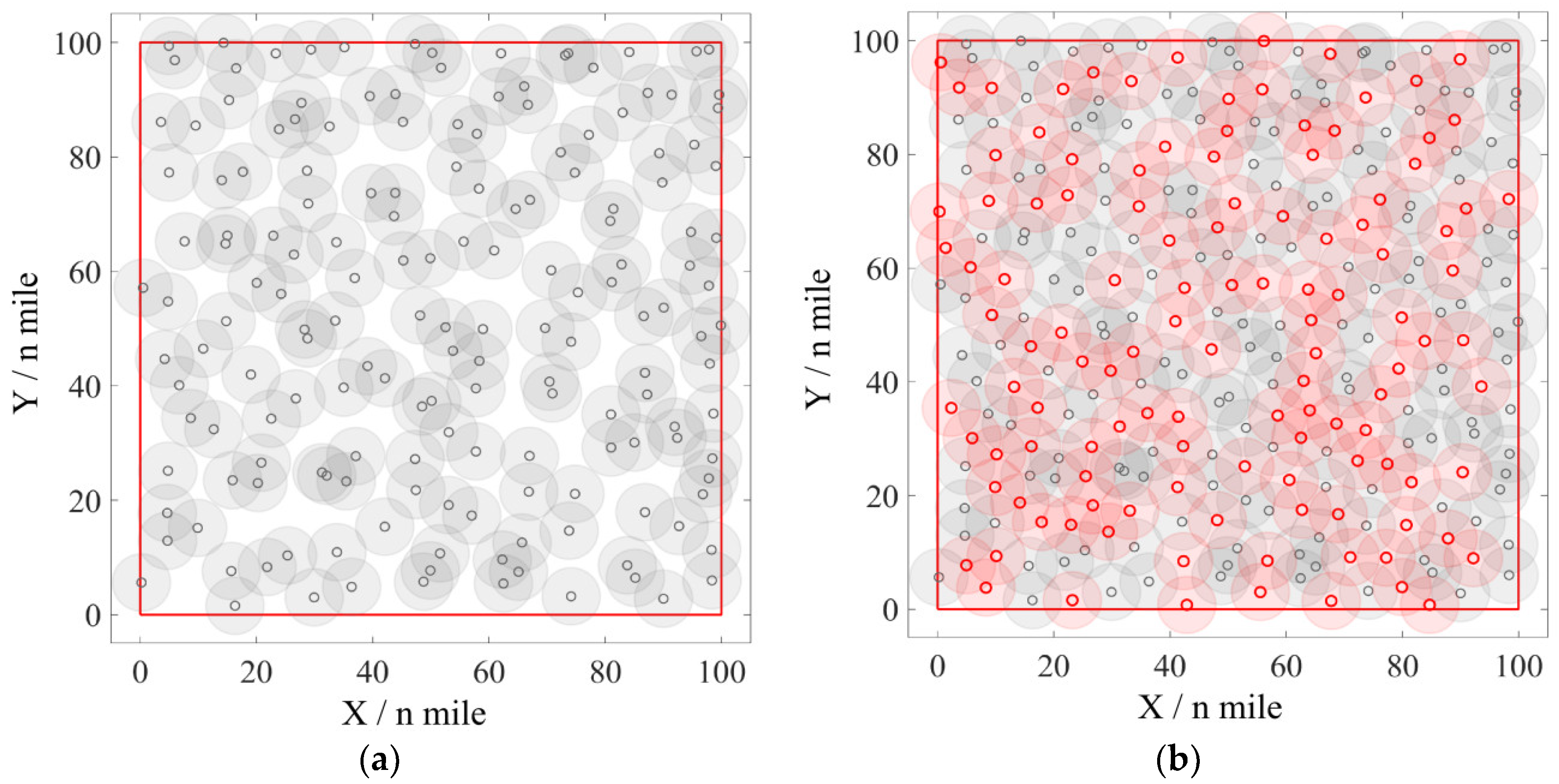
(1) A hybrid detection point layout combining Poisson disk sampling and Voronoi diagram gap filling is proposed. It generates a spatially uniform initial point set and iteratively fills coverage gaps via Voronoi vertices, optimizing both the number of detection points and coverage rate without discretizing physical constraints.
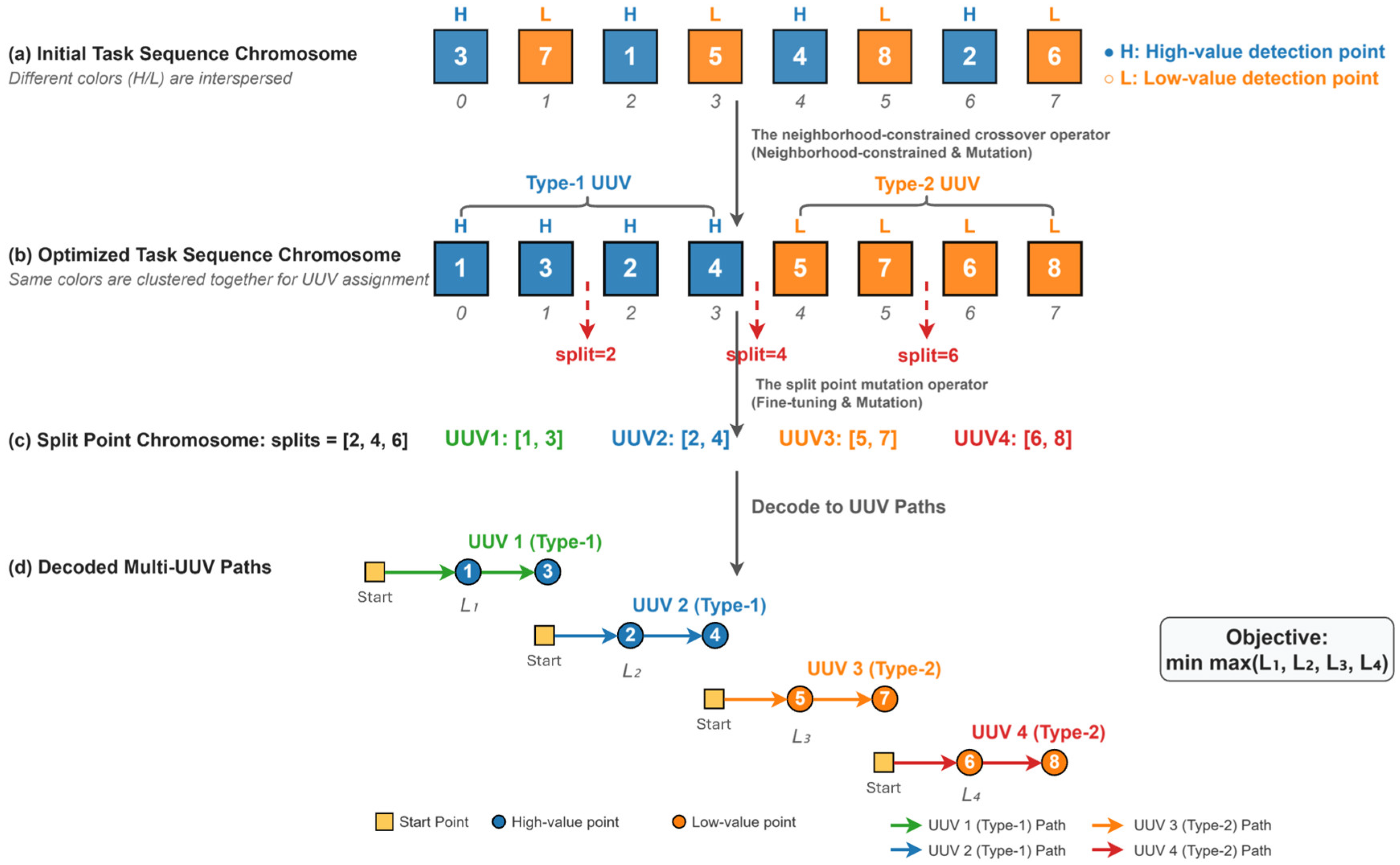
(2) A cooperative co-evolutionary encoding strategy with “task sequence + split point” chromosomes is designed for heterogeneous UUV load balancing. The two chromosomes evolve independently within the same individual while sharing a unified fitness, enabling simultaneous optimization of path topology and task load distribution.
(3) An integrated GA-based framework combining decomposition and obstacle avoidance is constructed. Connectivity-constrained K-means clustering decomposes the obstacle-laden MTSP into independent TSP subproblems, while a penalty matrix embedded in the fitness function converts obstacle avoidance into continuous path costs, reducing solution complexity while ensuring collision-free paths.
Table 1 systematically compares our method with representative studies from five key dimensions: core solution algorithm, subproblem composition, obstacle avoidance capability, heterogeneous agent support, and environmental adaptability.
As shown in
Table 1, most existing studies fail to simultaneously address obstacle avoidance, agent heterogeneity, and non-uniform task environments. In contrast, by integrating hybrid detection point layout, connectivity-constrained K-means decomposition, and dual-chromosome GA-based co-optimization, our method effectively balances path cost, heterogeneous agent constraints, and complex marine environmental factors.
2. Problem Formulation
The detection capability of a UUV is a function of the signal-to-noise ratio (SNR) received by its sonar system. According to the sonar equation [
37], the
received by the UUV at position P is given by:
where
is the source level,
is the transmission loss,
is the ambient noise level, and
is the directivity index.
The signal excess relevant to UUV detection requirements is written as:
where
is the detection threshold. The value of
directly determines the sonar’s probability of detecting a target.
It can be seen from Equations (1) and (2) that the sonar detection capability of UUVs varies with different locations, and this variation originates from the spatial changes in sonar performance and environmental parameters. Therefore, in full-coverage search tasks, not all areas are equally important. In fact, factors such as the prior distribution of possible target occurrence, the complexity of the marine environment, and mission priorities jointly determine the urgency and resource requirements for searching each sub-region. Hence, in this paper, we adopt the concept of search value to comprehensively characterize the importance of each position within the mission area. It should be noted that the search value can be quantified by various means, including the prior probability of target presence, environmental information entropy, or expert knowledge.
Based on the problem description above, the full-coverage search path planning problem can be formulated as the following mixed-integer programming model. Suppose heterogeneous UUVs are required to perform a full-coverage search mission on detection points, and the search value of each detection point is characterized by the value matrix . Each UUV departs from a fixed starting point 0, traverses its assigned set of detection points, and terminates at its last task point (without returning to the start).
The decision variables are defined as follows:
Objective Function:
where
is the actual traversal cost from detection point
to detection point
, defined as:
Here, is the Euclidean distance between points and , and is the obstacle avoidance penalty factor. The min-max objective function is adopted to minimize the longest path among all UUVs, thereby achieving balanced task load distribution across heterogeneous UUVs and preventing any single UUV from becoming a performance bottleneck due to excessive workload.
The above optimization problem is subject to the following constraints:
Coverage constraint: Each detection point is visited by exactly one UUV.
Flow conservation constraints: For each UUV, the number of arrivals equals the number of departures at each of its assigned detection points.
where the subscript 0 denotes the common starting point for all UUVs.
Subtour elimination constraints: To prevent disconnected closed subtours that are not connected to the starting point in any single UUV’s path, the Miller-Tucker-Zemlin (MTZ) formulation is adopted:
where
is an auxiliary variable denoting the position index of detection point
in the visiting sequence of UUV
.
Workload constraint: Each UUV is assigned at least one detection point to ensure that all UUVs participate in the mission.
Value-area adaptation constraint: Detection points in high-value areas are preferentially assigned to UUVs with smaller detection radii and higher detection precision (corresponding to effective detection radius ), while those in low-value areas are assigned to UUVs with larger detection radii suitable for wide-area coarse search (corresponding to effective detection radius ). It captures the matching relationship between heterogeneous UUV configurations and regional search values, representing a key feature that distinguishes our method from existing studies that assume homogeneous UUVs.
The above mathematical model and constraint set constitute a rigorous formalization of the full-coverage search path planning problem. This formalization provides a clear mathematical foundation for the connectivity-constrained clustering decomposition strategy, the dual-chromosome encoding, and the obstacle avoidance penalty mechanism introduced in
Section 3.2.
4. Experiments and Analysis
In this study, all simulations are implemented in Python 3.9. The two-stage random search planning model proposed by Wang et al. [
40] is selected as the baseline method. Specifically, the baseline method proposed by Wang et al. [
40] consists of two stages. In the first stage, random sampling is performed within the target sea area to generate an initial set of detection points, and their positions and density are iteratively refined to achieve effective coverage of the mission region. In the second stage, based on the generated point set, a standard genetic algorithm is employed to solve the single-UUV TSP, yielding the shortest route that traverses all detection points. The overall architecture of this baseline can be summarized as a two-stage paradigm of “random sampling + genetic algorithm.”
The selection of this model is mainly based on the following consideration: the two-stage framework of “sampling + path planning” of this model is consistent with the basic architecture of the proposed method. This ensures that the comparative experiment can exclude interference from differences in algorithm architecture, focus on verifying the effectiveness of the hybrid detection point layout method and the dual-chromosome encoding mechanism proposed in this paper, and quantify the specific contributions of the improvement measures in reducing detection redundancy and optimizing path cost. To validate the applicability of the algorithm in optimal scenarios for traditional geometric partitioning methods, this paper selects rectangular and circular sea areas as typical simulation scenarios.
To ensure the reproducibility and fairness of the experiments, all key parameters of the proposed method are systematically listed in
Table 2. These values were determined through preliminary sensitivity analysis and kept consistent across all experimental scenarios (circular, rectangular, and irregular sea areas). For the baseline method [
40], the parameter settings follow the original configuration reported in the literature, with the UUV search radius set to 5 n mile to align with the comparative conditions.
4.1. Circular Sea Area
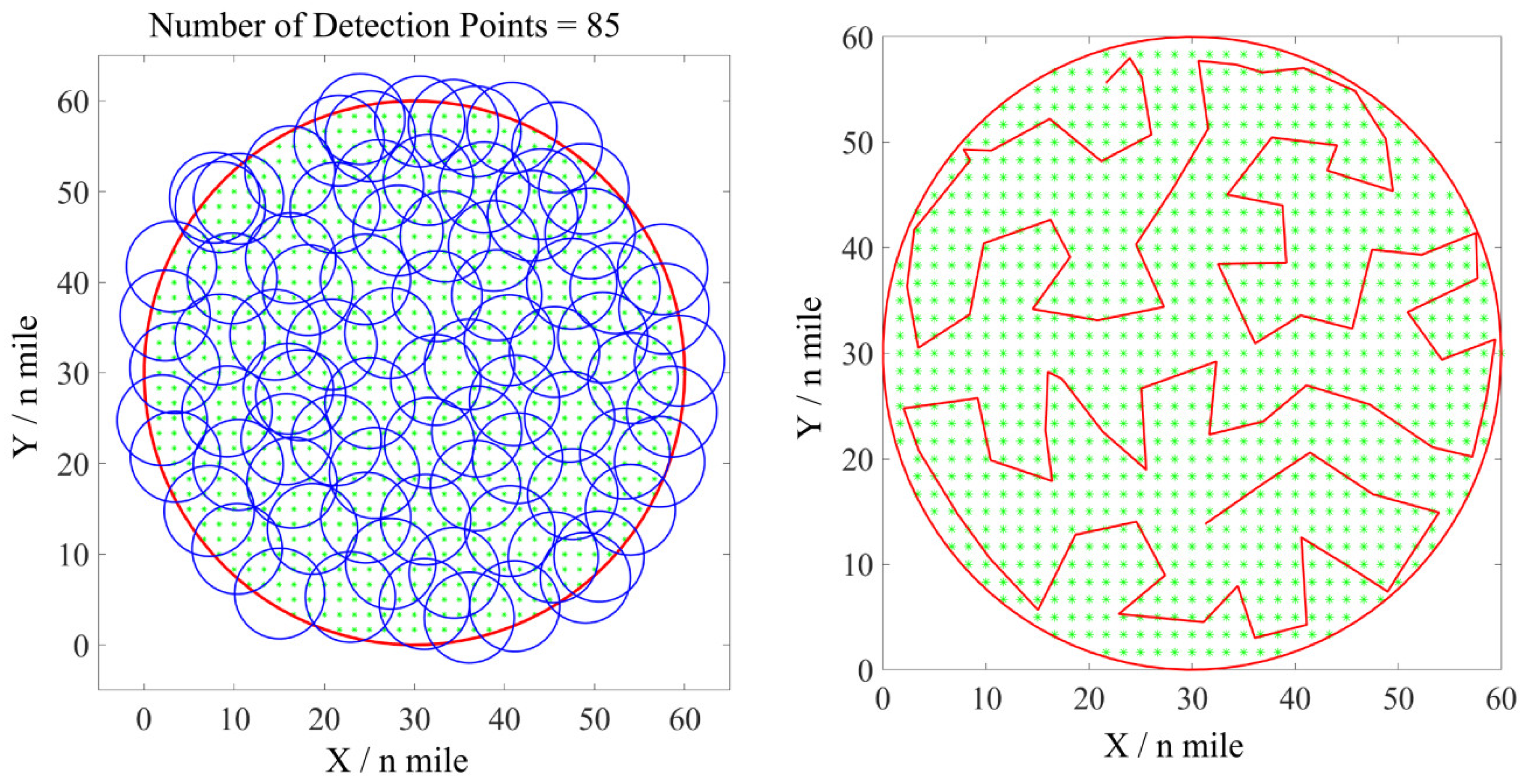
The radius of the circular simulation sea area is set to 30 n mile. In this task scenario, the baseline method plans a full-coverage search scheme with 97 detection points and an optimal search path length of 456.0 n mile. The proposed method achieves a full-coverage search scheme with 85 detection points and an optimal search path length of 429.5 n mile. The coverage search scheme and search path are shown in
Figure 3.
Table 3 presents a comparison of the baseline method and the proposed method in completing the full-coverage search task in the circular sea area. It can be seen that, compared with the baseline method, the proposed method reduces the number of detection points by 12.4% and the optimal path length by 5.8%.
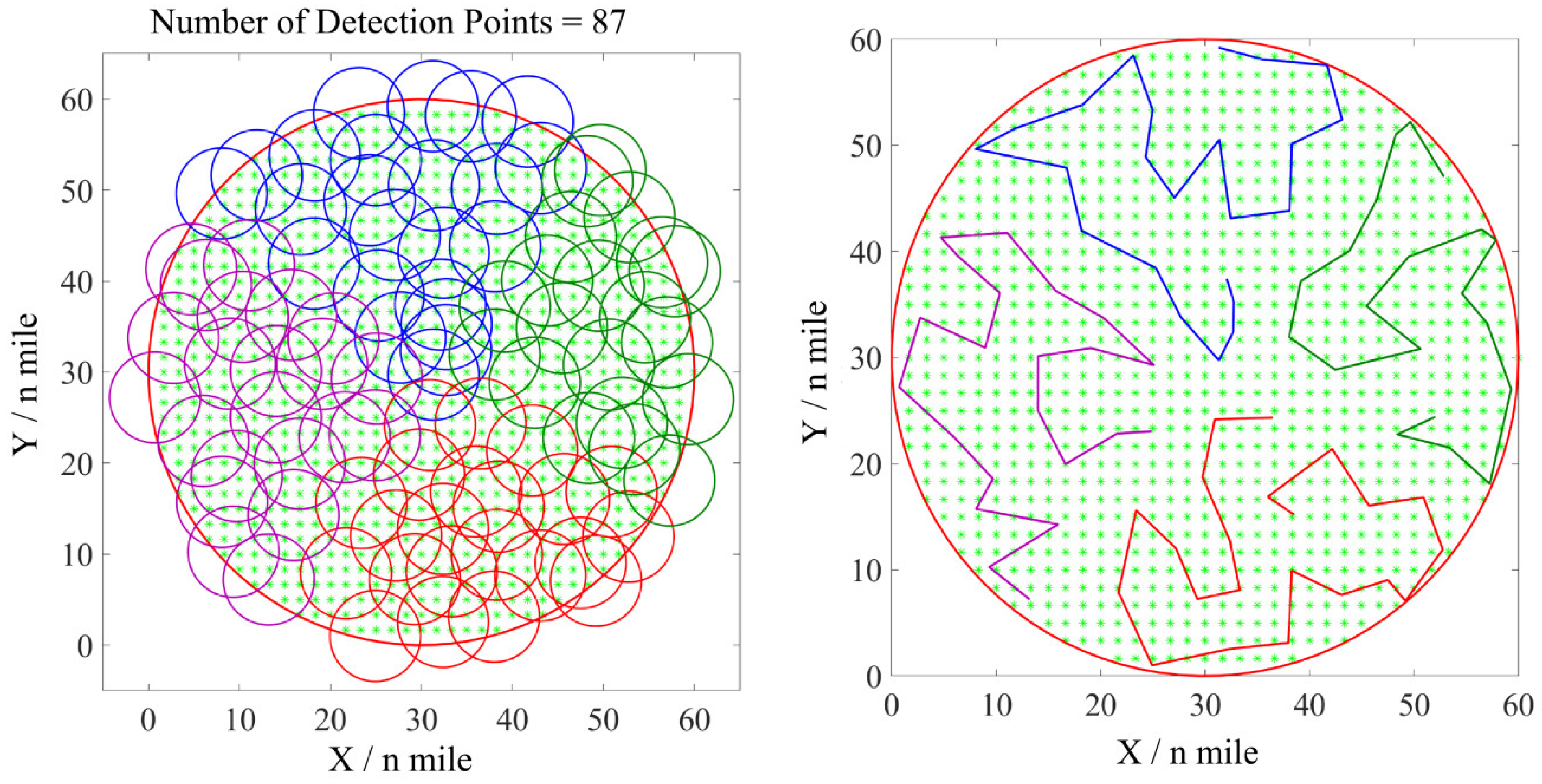
Compared with a single UUV, the task parallelism of multi-UUV coverage search path planning enables better time efficiency. In the aforementioned circular sea area, four heterogeneous UUVs (two of each type) are used for cooperative search. The number of planned detection points is 87 (slightly different from 85 in the single-UUV scenario, due to the randomness of Poisson sampling; the median of multiple runs is adopted in this paper). The path lengths of the UUVs are 111.9 n mile, 108.7 n mile, 96.1 n mile, and 109.7 n mile, respectively, with a total path length of 426.4 n mile. The coverage search scheme and the search paths are shown in
Figure 4. Compared with the full-coverage task scheme of the baseline method, the total number of detection points is reduced by 10.3%, and the total path length is reduced by 6.5%. When the speed of UUVs is fixed, the cooperative mission time is determined by the longest path among the UUVs. Compared with the single-UUV coverage search scheme, the four-UUV cooperative operation reduces the completion time for full coverage by 73.9%.
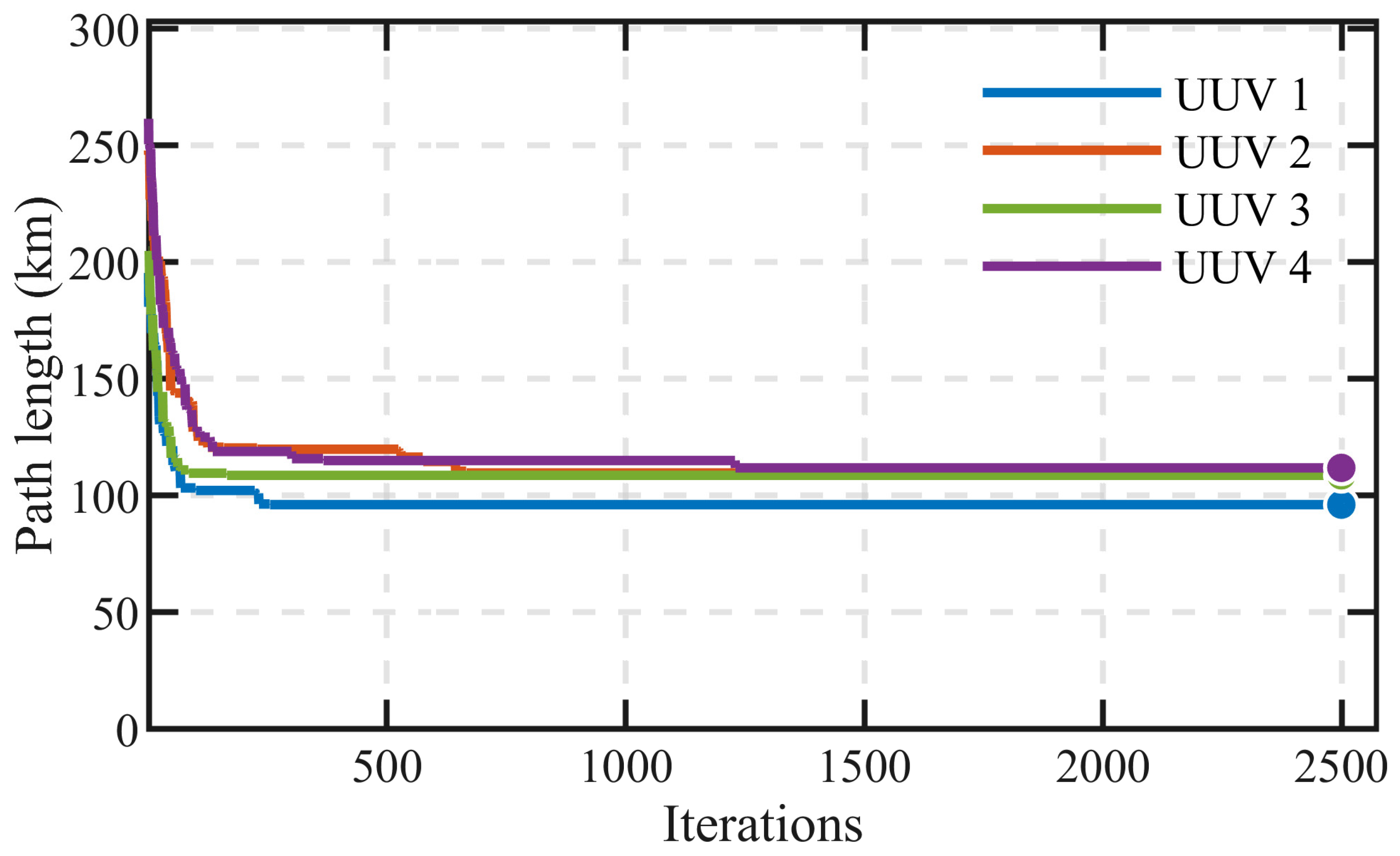
Furthermore, to validate the convergence performance of the algorithm,
Figure 5 presents the variation curve of the fitness value (i.e., the maximum path length) during the genetic algorithm iterations in the circular sea area (R = 30 n mile). As clearly shown in the figure, within approximately 700 generations, the fitness value drops rapidly from about 250 n mile to approximately 120 n mile; after 700 generations, the curve gradually stabilizes and fully converges to about 110 n mile by around 1250 generations. This convergence behavior demonstrates that the genetic algorithm exhibits favorable search efficiency and solution stability in circular sea area scenarios, and is capable of obtaining stable near-optimal solutions at an acceptable computational cost.
Additionally, the path lengths of the four UUVs in the converged solution are 111.9 n mile, 108.7 n mile, 96.1 n mile, and 109.7 n mile, yielding a standard deviation of 6.4 n mile, indicating that the algorithm achieves well-balanced task allocation among heterogeneous UUVs in the circular scenario.
4.2. Rectangular Sea Area
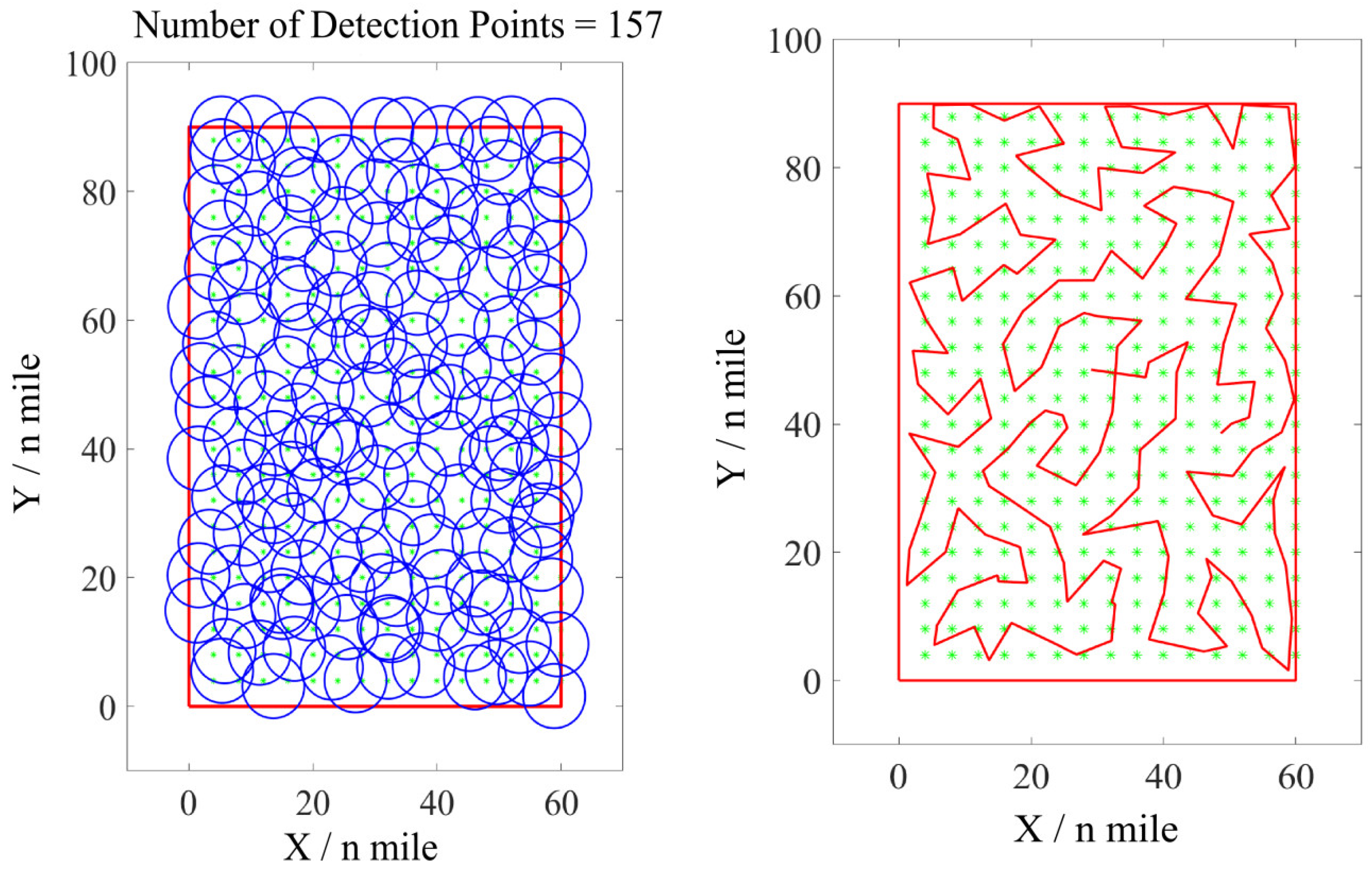
The length and width of the rectangular sea area are set to 90 n mile and 60 n mile, respectively. The baseline method plans a coverage search scheme with 180 detection points in this scenario, yielding a shortest path length of 883 n mile. The proposed method computes a full-coverage search scheme with 157 detection points and plans a shortest path of 843 n mile. The coverage search scheme and search path are shown in
Figure 6.
Table 4 presents a comparison of the baseline method and the proposed method in completing the full-coverage search task. It can be seen that, compared with the baseline method, the proposed method reduces the number of detection points by 12.8% and the optimal path length by 4.5%.
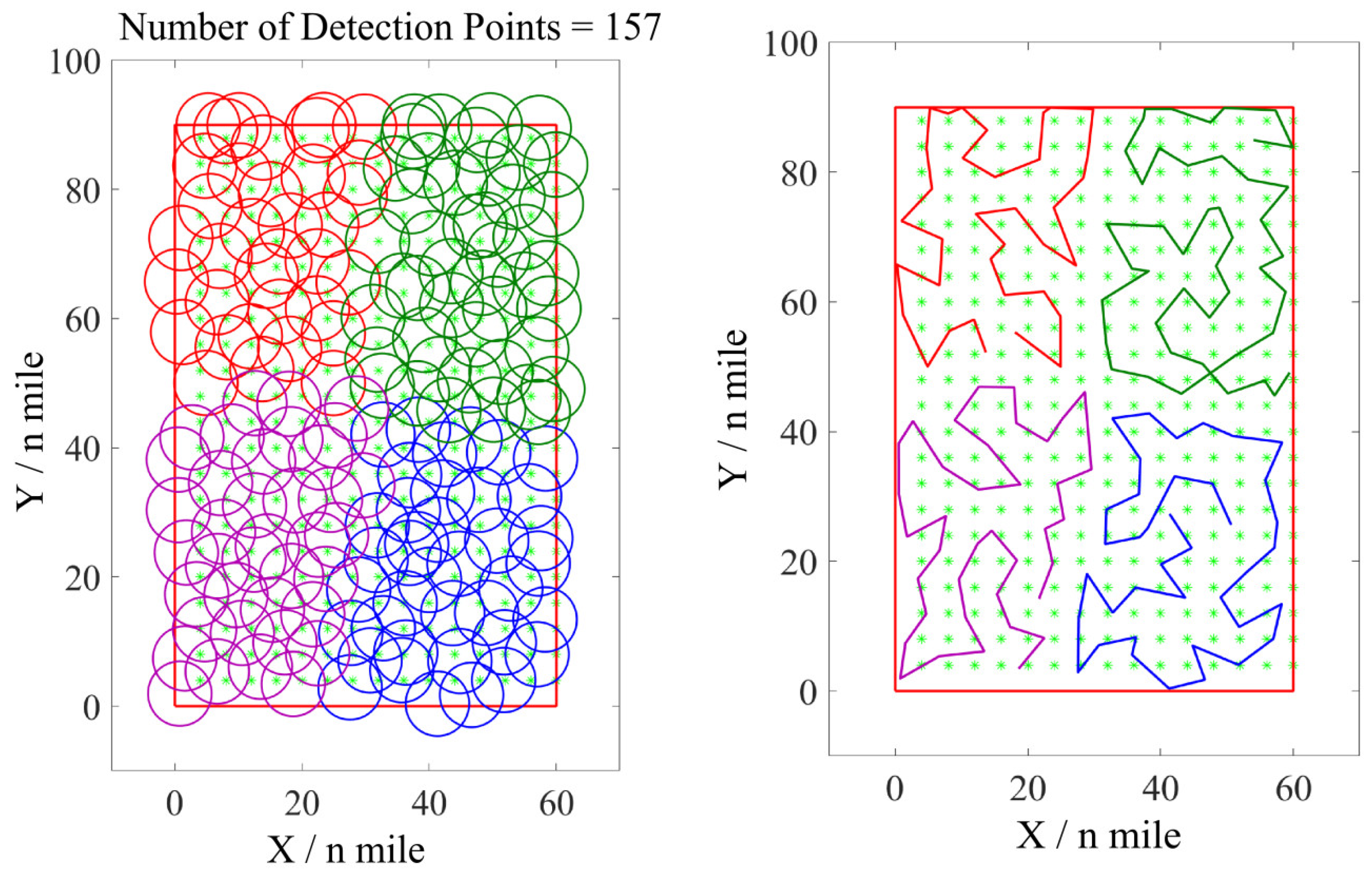
In the aforementioned rectangular sea area, four heterogeneous UUVs (two of each type) are used for cooperative search. The proposed method plans 157 detection points. The path lengths of the individual UUVs are 211.9 n mile, 189.6 n mile, 230.3 n mile, and 206.1 n mile, respectively, with a total path length of 837.9 n mile. The coverage search scheme and the search paths are shown in
Figure 7. Compared with the full-coverage task scheme of the baseline method, the proposed method reduces the total number of detection points by 12.8% and the total path length by 5.1%. When the UUVs travel at a fixed speed, the cooperative operation with four UUVs reduces the completion time for full coverage by 72.7% compared with the single-UUV coverage search scheme.
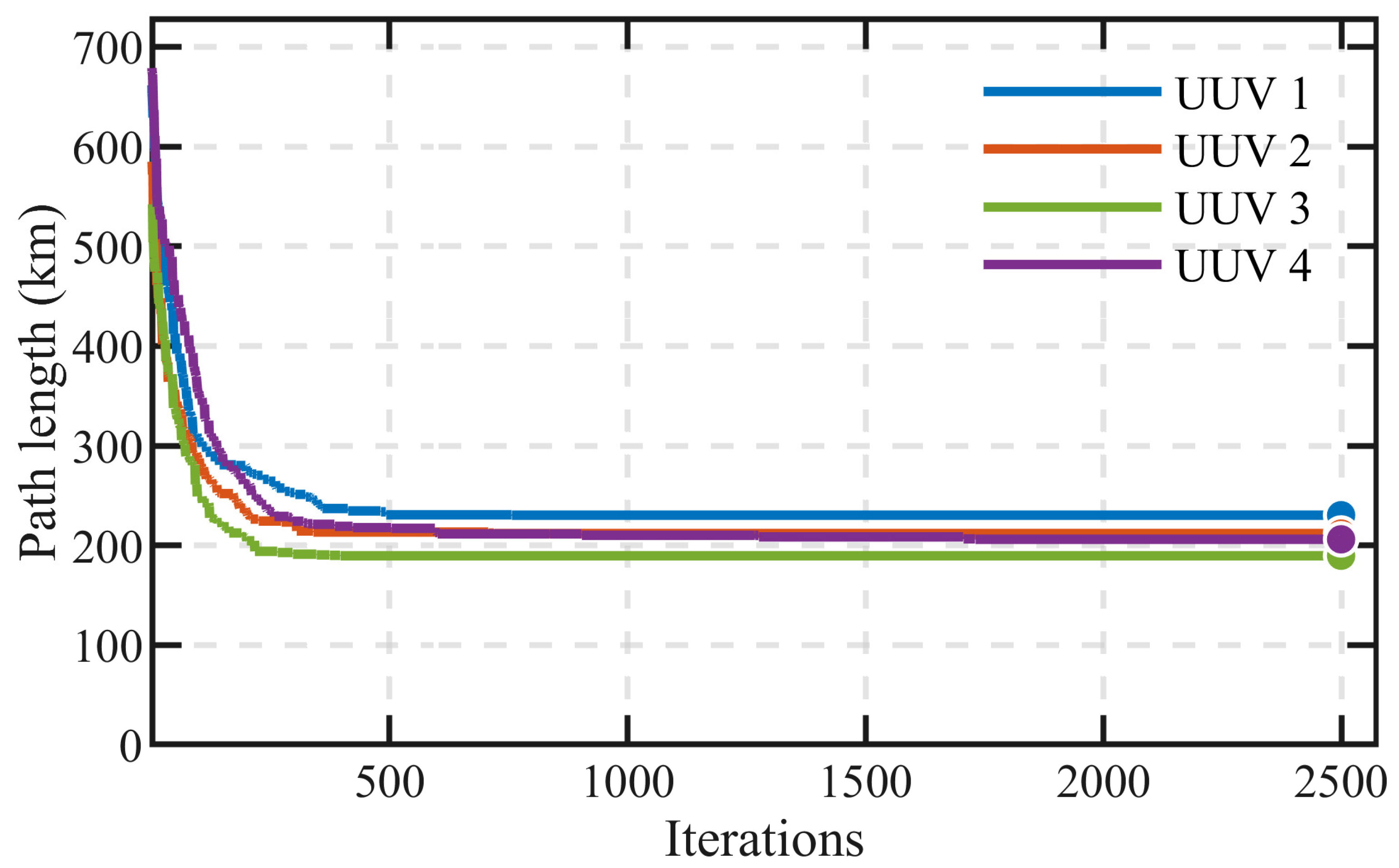
To verify the convergence performance of the algorithm in rectangular sea areas,
Figure 8 illustrates the variation in the fitness value with iterations in the rectangular sea area ((L, W) = (90, 60) n mile). Within approximately 600 generations, the fitness value drops rapidly from about 680 n mile to about 230 n mile, a reduction of over 66%; between 600 and 1750 generations, the curve exhibits a gradual decreasing trend, slowly optimizing from about 230 n mile to approximately 205 n mile; after 1750 generations, the curve fully stabilizes, indicating that the algorithm has converged to a stable near-optimal solution. The above convergence process verifies that the genetic algorithm can effectively search and stably converge under different aspect ratio conditions in rectangular sea areas.
In the converged solution, the four UUV path lengths are 211.9 n mile, 189.6 n mile, 230.3 n mile, and 206.1 n mile, with a standard deviation of 15.2 n mile, further confirming the algorithm’s load-balancing capability in rectangular sea areas.
4.3. Irregular Sea Area
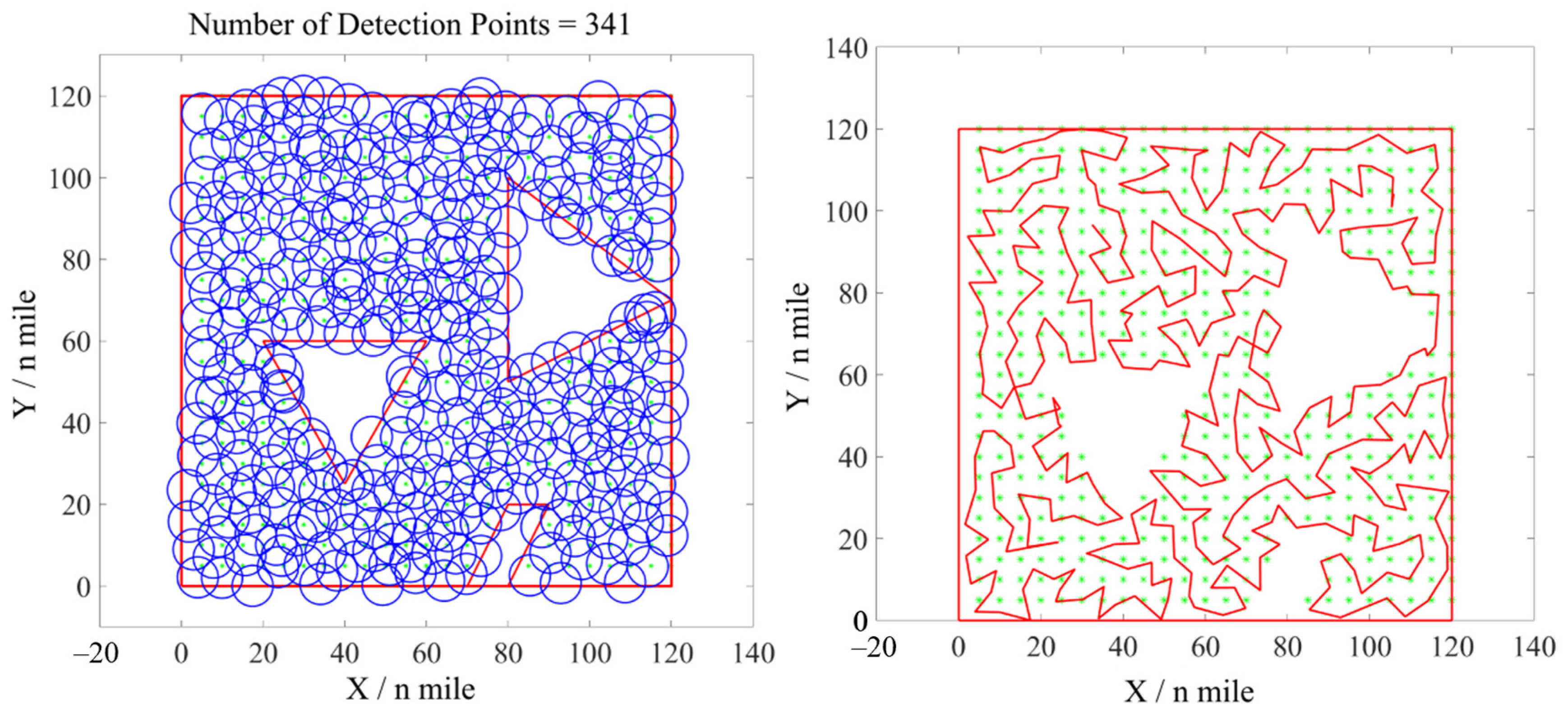
To address the limitations of grid discretization methods or traditional geometric search methods (e.g., parallel, zigzag, and spiral searches) when handling irregularly connected waters, including the difficulty of achieving complete coverage or the issue of path redundancy, this paper carries out simulation experiments in irregular sea area scenarios. The positional parameters of the irregular sea area are defined as follows: within a sea area bounded by [(0, 0), (0, 120), (120, 120), (120, 0), (0, 0)] n mile, there exist three inaccessible areas (islands, reefs, etc.) with coordinates of [(40, 25), (20, 60), (60, 60), (40, 25)] n mile, [(80, 50), (80, 100), (120, 70), (80, 50)] n mile, and [(70, 0), (80, 20), (90, 20), (80, 0), (70, 0)] n mile, respectively, as shown in
Figure 9.
In the above irregular sea area scenario, the baseline method plans a coverage search scheme with 376 detection points and a shortest path length of 2196 n mile; the proposed method plans a coverage search scheme with 341 detection points and a shortest path length of 2065.6 n mile. The coverage search scheme and search path are shown in
Figure 9.
Table 5 presents a comparison of the baseline method and the proposed method in completing the full-coverage search task. Compared with the baseline method, the number of detection points planned by the proposed method is reduced by 9.3%, and the optimal path length is reduced by 5.9%.
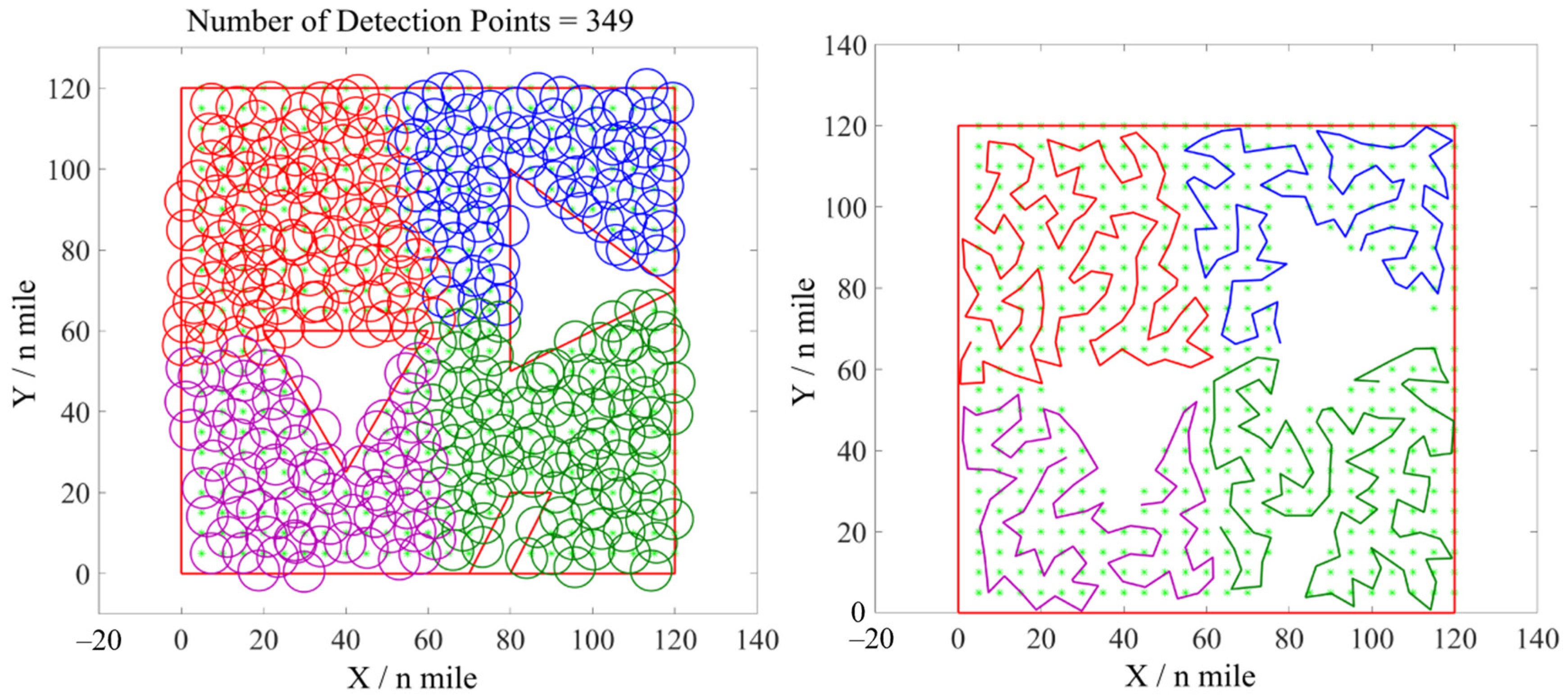
When four heterogeneous UUVs (two of each type) are used for cooperative search in the irregular sea area, the number of planned detection points is 349 (slightly different from 341 in the single UUV scenario, due to the randomness of Poisson sampling; the median of multiple runs is adopted in this paper). The path lengths of the individual UUVs are 451.5 n mile, 595.1 n mile, 562.6 n mile, and 448.5 n mile, respectively, with a total path length of 2057.7 n mile. The coverage search scheme and the search paths are shown in
Figure 10. Compared with the full-coverage task scheme of the baseline method, the total number of detection points is reduced by 7.2%, and the total path length is reduced by 6.3%. When the UUVs travel at a fixed speed, the cooperative operation with four UUVs reduces the completion time for full coverage by 71.2% compared with the single UUV coverage search scheme.
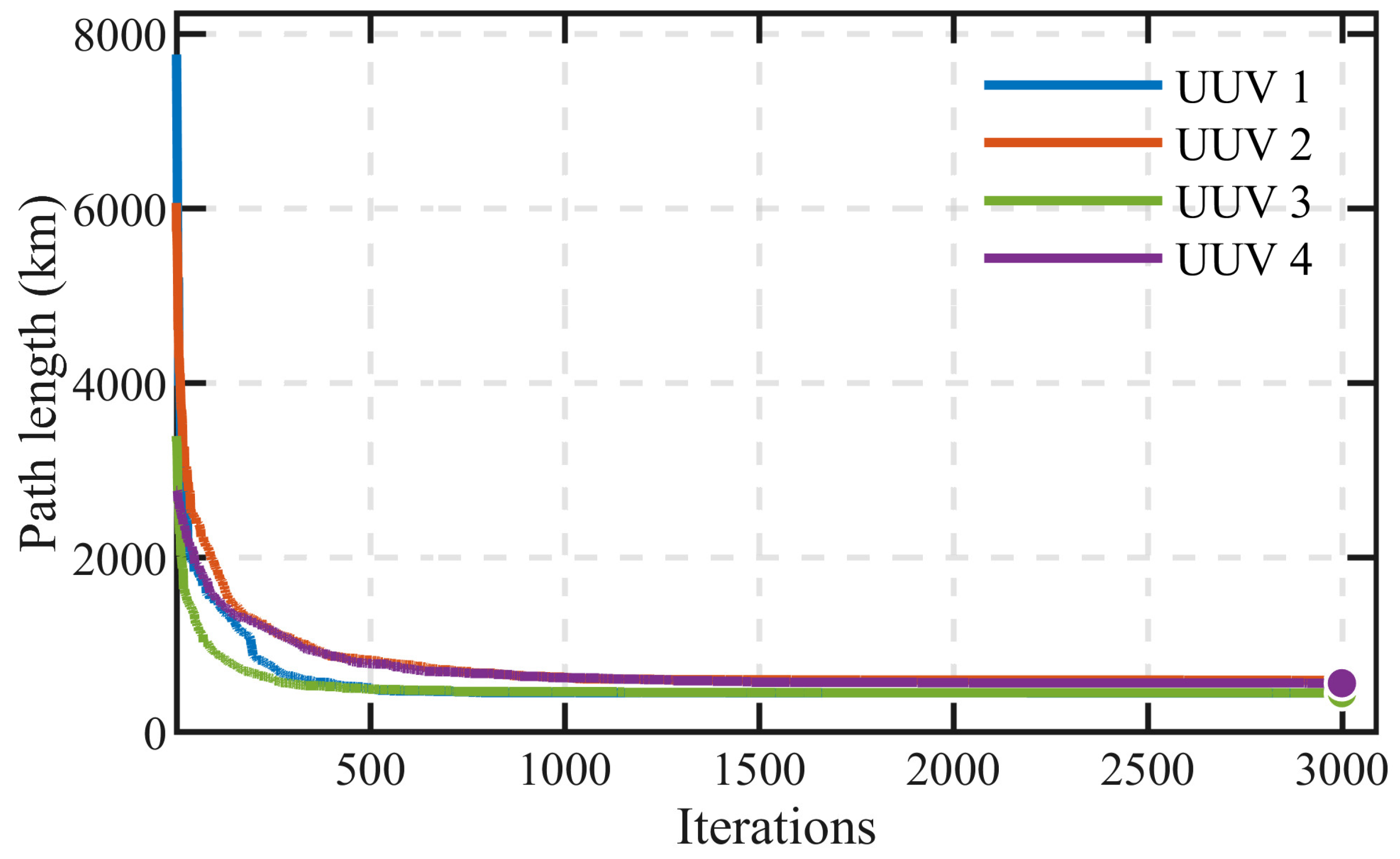
Regarding the convergence performance in irregular sea area scenarios,
Figure 11 presents the variation in the fitness value with iterations. Due to the presence of multiple obstacles in irregular sea areas, the search space is significantly fragmented, substantially increasing the solution difficulty compared with regular sea areas. As can be observed from the convergence curve, within approximately 1500 generations, the fitness value drops rapidly from about 7500 n mile to about 650 n mile, a reduction of up to 90%; thereafter, the curve enters a slow declining phase and gradually converges to approximately 550 n mile. Although the convergence speed is slower than that in regular sea areas, the algorithm is still able to achieve stable convergence within about 2500 generations, indicating that the proposed algorithm maintains good search capability and convergence performance even in complex obstacle-rich environments.
For the irregular scenario, the converged path lengths of the four UUVs are 451.5 n mile, 595.1 n mile, 562.6 n mile, and 448.5 n mile, with a standard deviation of 64.2 n mile. The relatively larger standard deviation, compared with the regular scenarios, reflects the increased difficulty of load balancing caused by obstacle-induced fragmentation of the search space.
4.4. Extended Experimental Validation
To further verify the robustness and generalization capability of the proposed algorithm, this paper extends the experimental scenarios from the three typical cases presented in
Section 4.1,
Section 4.2 and
Section 4.3 to 15 distinct instances. The newly added instances are generated by systematically varying the core parameters of each scenario type, with the specific divisions as follows:
(1) Circular sea areas (five instances): The shape is kept fixed while five different radii R = 20, 25, 30, 35, 40 n mile are configured to examine the algorithm’s adaptability to different regional scales.
(2) Rectangular sea areas (five instances): The area is kept approximately constant (≈5400 n mile2) while five different aspect ratio configurations (L, W) = (75, 72), (80, 67.5), (90, 60), (100, 54), (108, 50) n mile are set to evaluate the algorithm’s adaptability to different regional shapes.
(3) Irregular sea areas (five instances): The outer boundary is kept fixed while five different obstacle configurations are designed, with the number of obstacles increasing from one to five, to examine the algorithm’s capability in handling environments with increasing complexity of obstacles.
For the above 15 instances, the algorithm is independently run five times for each instance, and the following four key performance metrics are recorded: number of detection points—the total number of detection points deployed by the algorithm to accomplish the full-coverage task, reflecting the task scale and sampling efficiency; longest path length—the maximum single-path length among all UUVs, which directly determines the mission completion time in multi-UUV cooperative missions and serves as the core indicator of the algorithm’s time efficiency; total path length—the sum of all UUV path lengths, reflecting the overall energy consumption; standard deviation of UUV path lengths—this metric is a two-level statistic: first, the standard deviation of all UUV path lengths in a single run (denoted as X
i) is computed, where a smaller value indicates a more balanced task allocation among UUVs in that run; then, the mean and standard deviation are calculated over X
1, X
2, …, X
5 obtained from five independent runs, and presented in the table as “Mean ± Std.” Here, the mean reflects the central tendency of the load balancing performance over multiple runs, while the standard deviation reflects the stability of the load balancing performance—a smaller standard deviation indicates that the algorithm can stably achieve balanced task allocation under different random conditions. The final results are summarized in
Table 6 in the form of “Mean ± Std” to comprehensively reflect the average performance and stability of the algorithm.
From the experimental results presented in
Table 6, the following detailed analyses can be derived:
(1) Circular sea area instances (C1–C5): As the sea area radius increases from 20 n mile to 40 n mile, the number of detection points grows from 36.6 to 144.0, which is approximately linearly correlated with the increase in area. This validates that the Poisson-Voronoi hybrid sampling method maintains stable point density control capability across different scales. The longest path length increases from 52.8 n mile to 220.4 n mile, and the mean values of the standard deviation of UUV path lengths remain at a relatively low level of 4.2–13.5, with small standard deviations (i.e., small fluctuations across multiple runs), indicating that the algorithm can stably achieve good load balancing across different scales in circular sea areas.
(2) Rectangular sea area instances (R1–R5): With the area kept approximately constant at about 5400 n mile2, the number of detection points remains stable between 150 and 156, with very small fluctuations across instances (standard deviations within 3.7), further validating the algorithm’s stability in point density control. However, as the aspect ratio increases from 1.04 to 2.16, the longest path length gradually rises from 237.5 n mile to 277.8 n mile, and the mean values of the standard deviation of UUV path lengths also increase from 16.0 to 46.9. This trend indicates that the more elongated the regional shape, the more difficult it becomes to achieve balanced UUV task allocation—an inherent structural difficulty of the MTSP in non-compact regions.
(3) Irregular sea area instances (I1–I5): As the number of obstacles increases from 1 to 5, the number of detection points exhibits a non-monotonic trend of first increasing and then decreasing (304.8 → 323.0 → 351.6 → 316.4 → 309.6), indicating that the impact of obstacles on sampling efficiency is not a simple monotonic relationship but is closely related to factors such as the spatial distribution, shape, and degree of fragmentation of the obstacles. The longest path length and total path length also exhibit a similar trend of first rising and then falling, peaking at I3 (with 3 obstacles) at 640.0 n mile and 2252.4 n mile, respectively, before declining in I4 and I5. The mean values of the standard deviation of UUV path lengths are 25.5 in I1, rise to 71.4 in I3, and then decline to 57.1 and 49.4 in I4 and I5. This trend indicates that as the number of obstacles increases from 1 to 3, the connectivity of the sea area is progressively disrupted, increasing the difficulty of task allocation and decreasing load balancing performance. When the number of obstacles further increases to 4–5, the feasible region is more clearly divided into several independent sub-regions, which in turn allows the connectivity-constrained K-means decomposition to more naturally partition the detection points according to spatial connected domains, thereby restoring load balancing to some extent. The above phenomena demonstrate that the key performance metrics of the algorithm are significantly influenced by both the number and spatial distribution characteristics of obstacles, highlighting the engineering significance of properly evaluating algorithm performance in complex marine environments.
In summary, the proposed algorithm stably accomplishes the full-coverage task across all 15 different instances, with the standard deviations of the number of detection points, longest path length, and total path length all maintained within reasonable ranges, indicating that the algorithm maintains good robustness and generalization capability under various conditions including changes in regional scale, shape, and obstacle complexity. The mean values of the standard deviation of UUV path lengths remain at relatively low levels in most instances, with small fluctuations across multiple runs, validating the effectiveness and stability of the dual-chromosome co-evolutionary mechanism in heterogeneous UUV load balancing. It is worth noting that the results from rectangular instance R5 and irregular instance I3 reveal that when the regional shape is extremely elongated or the obstacle layout leads to highly fragmented search areas, the difficulty of load balancing increases significantly—this finding provides a valuable reference direction for future research on multi-UUV task allocation under complex maritime conditions.
5. Conclusions
When dealing with full-coverage search tasks, although traditional geometric methods are simple and efficient, they overly rely on regularity assumptions, making it difficult to cope with complex and variable marine environments. Moreover, in practical missions, there exist issues such as differentiated search values in target sea areas and imbalanced path allocation during multi-UUV cooperative search. To address these issues, this paper proposes a heterogeneous UUV full coverage search path planning method that combines a hybrid detection point layout method with a dual-chromosome co-evolutionary genetic algorithm. The main conclusions are as follows:
(1) To overcome the limitations of grid discretization methods or traditional geometric search methods, which often have difficulty in achieving complete coverage, a hybrid detection point layout method integrating Poisson disk sampling and Voronoi diagram gap filling is proposed. On the basis of ensuring a uniform spatial distribution of detection points, this method detects the maximum gap using Voronoi vertices and performs iterative filling, thereby reducing the number of detection points required for the full-coverage task. Simulation results show that in circular, rectangular, and irregular sea areas, the number of detection points planned by this method to achieve full-coverage search of the mission area is reduced by 12.4%, 12.8%, and 9.3%, respectively, compared with the baseline method, significantly reducing the task load.
(2) A co-evolutionary encoding strategy of “task sequence chromosome + split point chromosome” is designed for load balancing of heterogeneous UUVs. Within the same evolutionary individual, the two chromosomes evolve independently via heterogeneous operators but share the same fitness function, enabling simultaneous optimization of path topology and task load distribution. Simulation results demonstrate that the optimal path lengths planned by the proposed method in the three sea area scenarios are reduced by 5.8%, 4.5%, and 5.9%, respectively, compared with the baseline method. When the UUV speed is fixed, the mission times for full-coverage search with four cooperative UUVs are reduced by 73.9%, 72.7%, and 71.2%, respectively, compared with the single UUV case. This indicates that in all three scenarios, the mission time of the coverage search scheme planned by the proposed method is approximately inversely proportional to the number of UUVs, verifying the superiority of the algorithm in terms of balanced task allocation.
(3) Convergence analysis and extended experimental validation further confirm the effectiveness and robustness of the proposed method. The convergence curves of the genetic algorithm in circular, rectangular, and irregular sea areas demonstrate that the fitness value decreases rapidly in the early iterations and gradually stabilizes, with the algorithm reaching stable convergence at approximately 1250, 1750, and 2500 generations, respectively. This convergence behavior substantiates the search effectiveness and solution stability of the algorithm in obtaining high-quality near-optimal solutions. Furthermore, extended experiments on 15 instances—covering five radii in circular areas, five aspect ratios in rectangular areas with approximately constant area, and five obstacle configurations in irregular areas—show that the algorithm consistently maintains the standard deviations of detection point counts, longest path lengths, and total path lengths within reasonable ranges across all instances, with the mean values of UUV path length standard deviations remaining at low levels in most cases, thereby validating the algorithm’s robustness and generalization capability under varying regional scales, shapes, and obstacle complexities. It is worth noting that results from instances with extremely elongated rectangular shapes or highly fragmented irregular regions reveal that load balancing becomes significantly more challenging under such conditions, providing a valuable reference direction for future research on multi-UUV task allocation in complex maritime environments.