Review

Comprehensive Investigation of Unmanned Aerial Vehicles (UAVs): An In-Depth Analysis of Avionics Systems

Department of Electrical Engineering, Helmut Schmidt University, 22043 Hamburg, Germany
*
Author to whom correspondence should be addressed.
Sensors 2024, 24(10), 3064; https://doi.org/10.3390/s24103064
Submission received: 9 April 2024 / Revised: 1 May 2024 / Accepted: 8 May 2024 / Published: 11 May 2024
(This article belongs to the Section Intelligent Sensors)

Abstract

:
The evolving technologies regarding Unmanned Aerial Vehicles (UAVs) have led to their extended applicability in diverse domains, including surveillance, commerce, military, and smart electric grid monitoring. Modern UAV avionics enable precise aircraft operations through autonomous navigation, obstacle identification, and collision prevention. The structures of avionics are generally complex, and thorough hierarchies and intricate connections exist in between. For a comprehensive understanding of a UAV design, this paper aims to assess and critically review the purpose-classified electronics hardware inside UAVs, each with the corresponding performance metrics thoroughly analyzed. This review includes an exploration of different algorithms used for data processing, flight control, surveillance, navigation, protection, and communication. Consequently, this paper enriches the knowledge base of UAVs, offering an informative background on various UAV design processes, particularly those related to electric smart grid applications. As a future work recommendation, an actual relevant project is openly discussed.

1. Introduction

The evolution of Unmanned Aerial Vehicles (UAVs) is accompanied by instantaneous effects over many industries, thus reflecting a new era of telemetry, efficiency, and safety. At a first glance, agricultural surveying [1] and infrastructure inspection are alleviated by means of modern UAV technologies, hence reducing labor-intensive and risky tasks. From a different perspective, precision agriculture [2] is ameliorated through the sensors and cameras embedded in UAVs. Crop health can hence be better monitored, soil conditions accurately assessed, and resource utilization better optimized, contributing therefore to more sustainable farming practices [3]. Elsewhere, in military applications, UAVs with their highly versatile nature and reliability (i.e., remote control ability, durable flight periods, etc.), are found to be ideal for reconnaissance [4], border patrol [5], and disaster response [6]. Aside from agricultural- and military-based applications, environmental processes also benefit from UAVs, such that ecosystems can be remotely surveyed [7], wildlife can be dynamically tracked [8], and crucial data for conservation efforts and disaster management can be better gathered [9]. Forwardly, building inspection operations [10] and oil and gas infrastructure monitoring [11] can also be leveraged by means of UAVs for the commercial and industrial sectors [12]. For the part of mapping and surveying applications [13], terrains can be efficiently mapped, construction sites can be better monitored [14], and aid in urban planning [15] can be as well granted with high-resolution cameras and Light Detection And Ranging (LiDAR) sensors embedded in UAVs [16]. The ongoing innovation in UAV technologies, which is mainly based on advances in artificial intelligence [17], communication systems [18], and swarm technology [19], will eventually yield a continuous integration of UAVs into daily lives and industries [20]. It is of no doubt that UAVs are progressively evolving and widespread in diverse fields of application.
Despite the significant benefits and remarkable technological advancements associated with UAVs, their highly complex operational landscape implies various failure scenes [21], ranging from performance disruptions to risky mechanical failures [22]. Because of the sensitive hierarchies between the embedded electro-mechanical systems within UAVs, complexities arise from the integration of sensors [23], communication equipment [24], power systems, and others [25]. Firstly, UAVs can experience general system failures that are mainly linked to flight control programs [26]. Hence, maintenance challenges correspondingly emerge to ensure proper functioning. From another part, the inclusion of multiple electro-mechanical components yields increases in both the total weight of the drone and its power consumption, affecting its flight endurance [27]. Moreover, the interconnected system architecture induces a cascading failure effect when one component fails, potentially compromising the entire system [28]. Concerning the mechanical part, UAV’s continuous use and exposure to harsh operational conditions contribute to the wear-and-tear effect on different mechanical components [29]. A UAV’s structural frame and body can lose integrity, posing catastrophic consequences. Additionally, unavoidable vibrations [30] during flights induce resonance issues, successively leading to accelerated fatigue in the drone’s materials. In some applications, UAVs carry payloads, such as drop-off sensors or delivery packages [31], causing issues with their deployment or release mechanisms.
Besides mechanical failures, UAVs can be subjected to software bugs and glitches, leading to erroneous behaviors that affect their stability and performance [32]. For example, navigation errors are the result of inaccurate Global Positioning System (GPS) data [33] or misprocessed data in the UAV’s navigation algorithm [34], leading to deviations from the intended flight’s path. Regulation and compliance standards require a continuous update of UAV’s software to ensure continued adherence to legal and safety requirements [35], constituting a challenging chore. Where a UAV relies on remote communication systems for flight control and data transmission [36], any loss of communication (e.g., when UAVs operate beyond signal range limitations) poses a significant risk to the control and data transmission quality of the UAV (e.g., delayed responses and degraded data). Sensors inside a UAV, on the other hand, can be subject to failures [37], especially those that require precise calibration for accurate data interpretation [38]. Calibration errors or time-induced drifts lead to inaccurate readings (e.g., non-invasive current sensors reflect a false image over the actual current norm inside overhead electrical cables), hence compromising the performance of data collection [39]. In relation to the power systems inside a UAV, batteries (i.e., the main power source in a drone) can fail, with a sudden discharge or cell malfunctions [40]. Thus, the resulting loss of power can potentially limit the UAV’s flight time [41], and in the worst cases, causes the UAV to shut down and crash. On the other hand, environmental conditions [42] (i.e., weather) can impact UAV performance. For instance, proper UAV performance is affected by strong winds [43], heavy rain [44], and extreme temperatures as follows:
  • Water-related challenges (i.e., rain) result in UAV operational limitations [45] as water can leak into the UAV, permanently damaging sensitive electronic components.
  • Humidity: high levels of air humidity induce condensation and water accumulation inside a UAV.
  • High temperatures: the performance of semiconductors inside a UAV is greatly affected by high temperatures.
With the mentioned challenges and obstacles objecting to proper UAV performance, the more detailed the knowledge about different UAV subsystems is, the better the overall design will be. In other terms, a detailed analysis of the hierarchies between the electro-mechanical components of a UAV, in addition to the sensory parts, with algorithms and data processing, serves as a predictive UAV maintenance scheme. Eventually, the performance of a UAV will be optimized by better decision-making (i.e., in the design part) and problem-solving (i.e., after a fault occurrence). In accordance, there are many drone-related literature reviews in the field, which serve in turn as informative backgrounds about different aspects of UAVs. In [46], the established review took only into consideration the interactions between a UAV and the payload (i.e., suspended loads), whereas in [47], the state-of-the-art focused mainly on drone detection and classification techniques. From another perspective, the review in [48] identifies current gaps in the application of UAVs for the creation of 3D models in the contexts of urban planning and historic monuments preservation. The review in [49] took into consideration the diverse possible applications of drones in healthcare applications, whereas in [50], the main focus was on the study of marine mammals (i.e., individual estimation, body conditions and biometrics, behavioral patterns, etc.). On the other hand, the review in [51] examined the drone-integrated Geographic Information System (GIS) in different fields, differently from the work in [52], which focused on UAVs’ potential to advance climate change research and monitoring. Although the work in [53] mainly accounted for the UAV remote sensing of crop species, it included some of the multispectral sensors used in such applications, thus enriching the informative background about UAVs. In a more general approach, the review in [54] considered a structured presentation of the recent trends in the UAV field, classifying them according to their flight characteristics, showcasing the potential areas for further development, and addressing the hardware/software within a UAV. In [55], the research considered an overview of anti-collision technologies for UAVs with the associated types of sensors, whereas in [56], the focus was on UAV threat models, with security and privacy aspects. Divergently, in [57], the focus was on search and rescue operations driven by UAVs, whereas in [58], the review examined the deployment of UAVs for monitoring and inspection in the construction industry. Concerning the You Only Look Once (YOLO) algorithm used for real-time detection and classification of multiple targets, the work in [59] investigated the integration of YOLO with UAV technology and the corresponding practical applications (e.g., engineering, transportation, automation, etc.). Given that path planning holds significance in the context of drone autonomy, the authors of [60] reviewed the environmental representation as well as the path generation techniques for drones. Considering the potential of UAVs in warehouse management, a systematic literature review was conducted in [61], enriching the background of knowledge about the obstacles versus the adoption of UAVs in warehouse handling, unlike in [62], where the review primarily focused on the role of drones in flood management. Different UAV platforms for autonomous applications are reviewed in [63], which also presented the state-of-art and estimation techniques for UAVs, in addition to their correspondent flight phases.
As can be noted from the literature survey encompassing the modern reviews in [46,47,48,49,50,51,52,53,54,55,56,57,58,59,60,61,62,63], the majority of these articles actually focus on the UAV domain of usage and application fields. In other terms, there exist no reviews about the drones themselves, involving different architectures, structures, avionics, and software-to-hardware branches (i.e., the results of algorithms over the behavioral mechanism of sensors). Forwardly, as a matter of proof, and despite the extended application fields for UAVs such as concentrating solar thermal system planning and operation [64], intrusion detection [65], forest ecology [66], forensic civil engineering [67], plant-scale growth estimation [68], and photovoltaic plant diagnosis and maintenance [69,70], the available related reviews provide a less detailed informative background about the realm of UAVs. To address this issue, this paper aims to critically review and assess the different UAV facets, decomposed into five major sets including flight control and navigation, communication and remote control, computing and data management, sensing and monitoring, and power and energy management. The intended structure of this review aims to establish an informative background concerning the UAV compositional realm, instead of possible field applications, for UAV design processes.
The rest of this paper is structured as follows: Section 2 presents the research methodology used to obtain data, Section 3 outlines a general UAV operational overview in which a comprehensive synopsis of UAV operations is presented, Section 4 elucidates the actual review of different sets (i.e., subsystems) within a UAV, Section 5 discusses the obtained results, Section 6 highlights an actual UAV-based future project design with a corresponding link to this review, and finally, in Section 7, conclusions are derived.

2. Research Methodology

Because of UAVs’ widespread applications in various industries, as indicated in the Introduction, extensive literature in this field has arisen. This fact in turn creates a challenge while conducting a thorough review of UAVs’ internal structures and composers. To address this challenge, and to better guide interested audiences through the different aspects of UAVs, the systematic approach adopted here consisted of dividing a UAV into five main sets as follows:
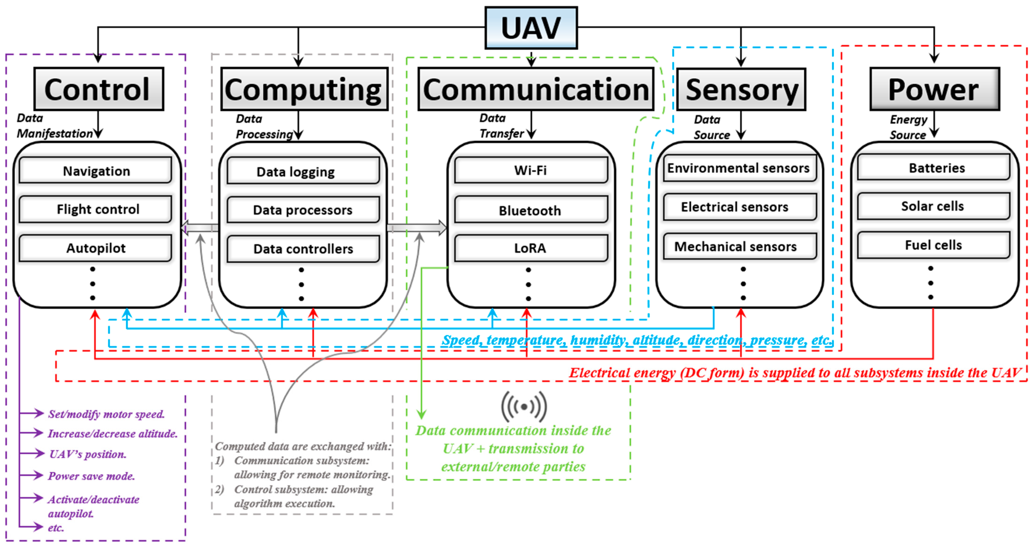
  • Control: This set includes navigation systems, flight control, autopilot, collision avoidance, target tracking, fail-safe, motor speed, and other related systems that are dedicated to managing and directing a UAV’s flight.
  • Computing: This set includes the computational elements including data processors, onboard computers, data loggers, and all computing platforms responsible for the execution of different algorithms.
  • Communication: This set includes the information exchange between a UAV and external parties (i.e., for remote control options) performed through different communication modules (e.g., Bluetooth, Wi-Fi, Long Range (LoRa) modules, etc.).
  • Sensory: This set includes data captured from internal (e.g., UAV’s power consumption and temperature), as well as external (e.g., altitude, pressure, and wind speed) environments held through UAV-embedded sensors.
  • Power: This set includes the energy sources (e.g., battery/solar cell drives), power distribution, and power management systems with the related circuitry to provide UAVs with optimal power for proper overall functionality.
Technically speaking, this research began by searching for relevant keywords, such as flight control in UAVs, avionics integration, UAV autonomous navigation, different power source types for launching UAVs, communication modules in UAVs, and others. In the first step, the corresponding results formed a large database, which was decomposed later according to the previously mentioned five main sets. Concerning the aim to inform readers about different aspects of UAVs, the conducted structure was developed in the form of relative answers to the following research questions (RQs):
  • RQ1: What are the different subsystems within a UAV?
  • RQ2: Is there any hierarchy between the different subsystems?
  • RQ3: Is there any integration between the subsystems?
  • RQ4: How can UAV reliability be enhanced by means of multiple sensory systems?
  • RQ5: What are the programming languages for different computing systems?
  • RQ6: What is the relationship between sensory and computing systems?
  • RQ7: How is the interdependence between subsystems managed?
  • RQ8: What are the standard UAV communication protocols?
  • RQ9: How can fail-safe be ensured in emergencies?
  • RQ10: How can limits be set for motor speed and UAV maximal altitude?
The answers to the raised questions consequently shaped the general overview of this manuscript, allowing thorough knowledge to be gained about the various facets of UAVs. The methodologies inside each set are mutually compared and assessed. Ultimately, concerning the resultant tabulated performance and other metric data for each set, the relevant discussed project highlights the contribution of this paper’s outcomes to the body of knowledge of UAVs.

3. UAV Operational Overview

Each of the main sets emphasizes a function (or a set of functions) as its collaborative job with respect to other sets, which are together aimed at achieving the accurate, stable, and successful flight of a UAV [71]. The key to a general understanding of UAV technologies is to establish a relationship between the five main sets according to two parameters, as discussed in this review, including hierarchy [72] and integration [73]. Figure 1 presents an overview of the hierarchy and integration between the five sets.
Additionally, a hierarchy exists between the composers of the same set. For instance, the commands from the autopilot system override the flight control and lead the navigation system [74]. The collision avoidance system utilizes data from the sensory subsystem as well as from the navigation system [75]. Higher prioritized hierarchies [76] (e.g., fail-safe) override and modify commands and data from other systems, where, for example, all sensory data would be instantaneously blocked to reduce computational efforts on the central processor and ensure that the UAV shuts down safely. As for hierarchies between the composers of different sets, the data processors on the first hand receive inputs from sensory subsystems, and sometimes from the control subsystem, for real-time processing [77]. The equipped computers on the UAV manage and coordinate tasks across all subsystems by executing flight control algorithms based on the processed data [78]. Data loggers, on the other hand, save different input data for further investigation during the same flight (i.e., metaheuristic analysis-based flight modification) or offline (when the UAV is not on a mission) [79]. The UAV’s health and performance indices are captured by internal sensors, thus providing data to both the control and computing subsystems, where external sensors share environmental data with the corresponding computing subsystem for decision-making [80]. As shown in Figure 1, the control subsystem establishes real-time decision-making and executes flight control algorithms when integrated with the computing subsystems (i.e., based on the processed data output from sensors). In turn, the communication system, aside from facilitating interaction/integration among all subsystems, enables real-time command reception/execution when integrated with the control subsystem. From the different perspective of integration/hierarchies, a UAV’s technology may implement mechanical redundancy systems [81] (i.e., to ensure reliability in the case of failures), encryption [82] (i.e., for secure data exchange/communication), and payload swing suppressor [83], which can act as standalone subsystems.

4. Avionics Assessment

As indicated in the Introduction, this review consists of five main subsystems of UAVs (control, computing, communication, sensory, and power). Concerning the control review, it includes different schemes for navigation (strategy, path planning/obstacle avoidance, localization), target tracking, and payload integration. The computing-based review encapsulates the different single-board computers, as well as the system on modules, used for data processing in UAVs. The communication review presents the possible communication protocols along with their relative modules, which can be UAV-embedded. Sensors are mainly classified as environmental-, vision-, and position-based, with each set including different technically reviewed physical sensors. Finally, the power review includes different sources that can be utilized to power up UAVs.

4.1. Control

The control subsystem inside a UAV manages and directs its flight operations, with its decision-making process relying on sensory data. Its primary purpose is to exercise precise command over the UAV’s navigation, stabilization, movements, positioning, balancing, take-off, and landing. In other words, the control subsystem acts as the brain and steering mechanism of a UAV. As can be concluded from Figure 1, the computing subsystem interacts with the control subsystem by providing the necessary algorithms, whereas the communication subsystem allows dynamic adjustments through real-time data exchange.

4.1.1. Navigation

Assuming that a UAV has its path already determined (i.e., concerning its mission, purpose of usage, etc.), its navigation involves the real-time process of guiding it along that path. It can therefore be perceived as the constant monitoring of the UAV’s position, velocity, and orientation with respect to the planned trajectory. As a short general description, under the control subset of a UAV, navigation refers to the ongoing execution and adjustments of the UAV’s movement along its planned path. Other related reviews in the field mainly classify UAV navigation techniques as either indoor (i.e., used in closed areas where GPS signals, for example, can be weak or unavailable), or outdoor environments (i.e., for aerial surveying, crop monitoring, and rescue missions). Indoor navigation methods, on the one hand, can be achieved using a packet loss-based approach [84]. In GPS-denied environments, a drone is capable of estimating its current position based on the wireless packet loss from a reference point packet transmission. Specifically for indoor corridor environments, a UAV can be navigated through a Convolutional Neural Network (CNN), resulting from the combination of ResNet and DenseNet networks [85]. The CNN analyses the images captured by the UAV’s monocular camera and estimates the position/orientation of the UAV relative to the environment. A precise indoor UAV location estimation can also be obtained by means of ultrasonic acoustic signals with a three-stage localization scheme [86]. Outdoor UAV navigation methods, on the other hand, mainly rely on GPS [87], Inertial Navigation System (INS) [88], Global Navigation Satellite System (GNSS) [89], integrated INS/GNSS [90], and others [91]. This manuscript, however, conducts another approach for reviewing UAV navigation techniques, namely, classified as navigation strategy, path planning/obstacle avoiding, and localization.
  • Strategy
(a)
Vision-based techniques
In general, vision-based navigation techniques have evolved from the need for proper UAV navigation in GPS-challenging (i.e., indoor) environments and for collaborative navigations for swarms of UAVs. This is also the case when two UAVs exist in contradictory environments, where one UAV operates under a good GPS coverage, unlike the other. In such circumstances, the navigation can be held using a father–son information exchange [92]. By means of line-of-sight (LOS) communication between the father and son UAVs, navigation information can be exchanged and acknowledged to the son UAV through the father UAV installed onboard camera, thus providing related data such as the Body Reference Frame (BRF) [92]. Vision-based navigation systems for UAVs can also act as backup for signal-enabled navigation methods (e.g., GPS, INS, etc.) for cases of jamming and drift errors, where the pre-obtained latitude and longitude data are utilized after their integration with the Google static map Application Programming Interface (API). UAV position estimation is hence acknowledged using matching techniques, such as normalized cross-correlation with prior edge extraction [93]. Map generation during navigation is another effective vision-based technique to guide a UAV under undesirable weather conditions (e.g., rain, storms, etc.) [94]. For instance, a high-resolution depth map can be developed by means of segmented optical flow from two successive frames, yielding a dense map picture reconstruction by optimizing a convex algorithm [95]. On the other hand, by means of a stereo visual-inertial (SLAM), with a two-step refreshing approach of an awareness map, the occupancy state (i.e., positioning cells in the map) is then updated, thus allowing for a visualization-enabled UAV navigation [96].
Vision-based navigation for UAVs is a popular trend in the field of UAV technology, mainly because of its sequential working mechanism, utilizing real-time target, environmental, and other data as the basic input to reveal a UAV’s instantaneous position after data processing through an onboard computer [97,98,99,100]. Overall, this set of navigation strategies relies on visual clues, thus offering dynamic spatial awareness for the UAV to build decisions upon. For instance, a UAV can navigate through unstructured terrains with precision because of real-time visual data interpretation. The BRF, on the other hand, ensures an accurate maneuvering of the UAV, as is the case with map construction (i.e., through harnessed images). From another perspective, vision-based strategies, mainly dependent on graphics, are susceptible to poor lighting conditions and visual clutter, leading unfortunately to errors in navigation. Table 1 encapsulates the pros/cons of vision-based UAV navigation methods, along with the incorporated challenges and different considerations.
(b)
Artificial Intelligence (AI)-based techniques
Unlike vision-based navigation techniques, Artificial Intelligence (AI) contributes toward better autonomy in UAV navigation [101], mainly by allowing drones to learn from their surroundings [102]. From another perspective, AI allows for automatic feature extraction while better managing onboard resources, which differentiates it from traditional cognitive algorithms [103]. Concerning UAV navigation, AI algorithms are characterized in this manuscript according to their paradigm as follows: AI algorithms that involve mathematical model formulation to find the best solution to a given problem by relying on predefined rules and objectives to guide the UAV are grouped in the first set (i.e., mathematical optimization) [104]. The other set emphasizes a paradigm that trains the models to make better decisions in UAV navigation (i.e., performance is evolved over time based on training data and gained experience) [105].
(b.1)
Mathematical optimization
For any given non-deterministic polynomial complex problem (i.e., the navigation path of a UAV), mathematical optimization-based AI approaches achieve near-optimal solutions [106]. The most dominant algorithms in this field are Particle Swarm Optimization (PSO) [107], Ant Colony Optimization (ACO) [108], Genetic Algorithm (GA) [109], Differential Evolution (DE) [110], and Gray Wolf Optimization (GWO) [111], as assessed in Table 2 and defined below:
  • PSO: the optimal path for particles (i.e., drones with a swarm) can be attained by means of a competition strategy-based PSO, after comparison between the current global path with respect to other global candidates [112].
  • ACO: the premature convergence of a single-colony ACO algorithm can be overcome using multi-colony ACO, where multiple UAV groups search for the optimal routes to the destination [113].
  • GA: the 3D position of a UAV is encoded into a chromosome which in turn contains information about the UAV’s position/motion (e.g., acceleration, rate of the climbing angle, rate of the heading angle, etc.). The present-time 3D coordinates are obtained from the chromosome decoding and then evaluated by a fitness function. Eventually, path selection and information loss/exchange are referred to genetic operations [114].
  • DE: in the case of a disaster (i.e., the navigation becomes harder), a constraint DE converges toward the optimum UAV route by selecting the high fitness values and minimum constraint violations among all probable traveling points [115].
  • GWO: for fast convergence and efficient environmental exploitation, the conventional GWO can be hybridized with other algorithms (e.g., modified symbiotic organisms search), eventually yielding better UAV path navigation [116].
Each of the algorithms presented in Table 2 is nature-inspired, and they all aim to efficiently explore the space of available solutions to achieve the best/optimal solution (i.e., in this case, the best navigation route). Additionally, they utilize a population-based approach, such that multiple candidate individuals (e.g., swarms in the case of PSO) are iteratively improved. Optimal performance (i.e., finding the optimal route) is eventually achieved by means of parameter tuning. In comparison with vision-based navigation techniques, such algorithms require no image processing, thus implying no graphics complexities (e.g., resolution, light conditions, etc.). The shared drawback among these algorithms is the slow and/or premature convergence, reflecting reduced navigation accuracy.
(b.2)
Training models
Representing model-based AI algorithms, training models aim to achieve near-optimal solutions (i.e., best route/path for a UAV) by means of self-training and to learn how to perform continuously better decision-making [117]. On the one hand, Reinforcement Learning (RL) [118,119,120] allows UAVs to learn about the environment, yielding optimum navigation. Because an agent and the environment represent the fundamental component of RL, through interaction with the latter, an optimum path can be chosen by the agent (i.e., UAV) using a Markov decision process [121]. From another perspective, based on the reward-to-target compensation system (i.e., the closer the UAV to the target, the more reward given by the environment), a Q-learning algorithm navigates an indoor UAV through the control of a Proportional Integral Derivative (PID) controller [122]. Amid the Q-learning algorithm context, Deep Reinforcement Learning (DRL) can be utilized for UAV navigation by using Q-values, such that the Q-table is replaced with a Deep Neural Network (DNN), hence offering better scalability [123]. Instead of performing repetitive manual calculations, as is the case with the Q-table, the DNN can make predictions and visualization the same way the human brain does [124]. Deep Learning (DL), on the other hand, with its different types such as Fully connected Neural Networks (FNNs) [125] and Convolutional Neural Networks (CNNs) [126], helps in autonomous UAV navigation under harsh environments by only utilizing the DNN part of the DRL. For instance, a UAV can be navigated through DNN by means of an image augmentation method [127], as well as via real-time photos and CNNs [128].
Despite the numerous advantages offered by training model-based AI in the field of autonomous UAV navigation, such techniques require long training time and large computational power, in addition to presenting high complexity in algorithm implementation, the need for extended information updates, and slow adaptation to new environments [129,130]. Generally, machine learning algorithms, as in the stated examples of FNNs and CNNs, are restricted by computational power. This is mainly due to their functional mechanism, which resembles heuristic search algorithms. In other terms, such training models use computers to search and resolve the algorithm automatically through massive trial-and-error. The algorithm is hence modeled using parametric optimization, beginning with the framework, equations, and structure defined with initial parameters. The end goal in these training models is to find the optimized parameters, through which the problem (in this case, finding the best route for a UAV) can be solved. Therefore, smarter training models (i.e., with more parameters to achieve a sharper convergence toward an optimal solution) require more computational power. For such reasons, and in order to reduce complexities in the hardware (e.g., GPU) implementation of these models, modern research aims to optimize DL models by reducing their energy consumption and memory requirements. By means of parameter quantization and pruning, network architecture search, knowledge distillation, and compressed convolutional filters, the high computational power of CNNs and FNNs can be reduced [131].
  • Path planning/obstacle avoidance
Navigation strategies encompass the overall approach guiding the UAV, mainly including the physical execution of algorithms through actuators (i.e., motors). It is unlike path planning and obstacle avoidance, which focus on determining the optimal trajectory while reacting to the real-time obstacles encountered along the planned path. In other terms, path planning/obstacle avoidance considers a feasible trajectory for the UAV to follow between start and end points, ensuring a smooth path while detecting and avoiding obstacles in the airspace. For the mentioned purpose, on the one hand, there exist passive and active sample-based algorithms, such as rapidly exploring random graphs [132], Probabilistic Road Maps (PRMs) [133], Rapidly exploring Random Trees (RRTs) [134], and Dynamic Domain RRT [135]. In addition, obstacles can be momentarily avoided (i.e., collision-free path) in collaboration with the RRT algorithm [136]. Other path-planning algorithms can also be mathematically based (e.g., Mixed-Integer Linear Programming (MILP) [136], integer programming [137], and non-linear programming [138]). Different path planning algorithms can also be fused together to obtain better convergence accuracy and to overcome the drawbacks of each algorithm. For example, in [139], a 3D PRM is used to form the roadmap, combined with the A* node-based optimal algorithm, to find the optimal obstacle-free path. From a different perspective, path planning can be bio-inspired, as such algorithms require less learning. For instance, the Bio-Inspired Neural Network (BINN) and Sparrow Search Algorithm (SSA) in [140] scan the flight environment, smoothing it for further safe surface obtainment. By means of SSA, the nodes are determined with the lowest comprehensive cost, hence achieving dynamic obstacle avoidance. Table 3 lists different sets of path planning and obstacle avoidance algorithms.
  • Localization
The localization of a UAV is the process of determining its position in a given environment, involving the obtainment of accurate information about the UAV’s spatial coordinates (i.e., latitude, longitude, orientation, etc.). In relation to other navigation hierarchies (e.g., path planning), it enables a precise execution of the planned paths and strategies [141,142,143,144,145]. Concerning vision-based UAV localization techniques, they can be characterized according to two main sets as follows: Relative Visual Localization (RVL) [146,147] and Absolute Visual Localization (AVL) [148]. Among RVL methods, the popular Visual Odometry (VO)-based techniques [149] analyze the difference in “egomotion” by comparing between current and previous frames while performing with Optical Flow (OF) analysis [150]. Generally, all RVL methods suffer from drift over time [151], ignited by the usage of recursive estimations in order to formulate new estimations. Because of this, AVL methods have evolved in the field of UAV localization, mainly because of their inherent immunity against drift over time. Unlike the working mechanisms for UAV localization in RVL methods, AVL localizes a UAV by means of reference data, which are mainly composed of precisely georeferenced aerial images [152]. For example, a UAV’s absolute position can be acquired by means of normalized cross-correlation [153], as well as via a Mutual Information (MI)-based dense approach, as shown in Figure 2 [154].
The global reference map in Figure 2 is constructed from a mosaic of georeferenced images, such that an “sRt” model (i.e., accounts for the 3D motions) is produced for usage after an assumption of a planar ground and a UAV image that is parallel to it, defined as in (1).
w X t , μ = s R 2 d x t + t 2 d
where R 2 d   represents a 2D rotation, s   is a scale factor, x t   is a point in space, and t 2 d   is a 2D translation. The MI function’s maximum is found using Newton’s optimization warped in the “sRt” model with respect to the global reference map. Results indicate small relative mean squared errors in the localization data [154]. AVL methods for UAV localization overcome the drawbacks of GNSS-based localization methods, such as reception issues [155], spoofing attacks [156], and signal degradation [157].

4.1.2. Target Tracking

Within a UAV’s field of vision, target tracking refers to its process involving the identification and localization of certain objects or points of interest [158]. Such a procedure begins with data capturing (i.e., images of the surroundings) [159] through the embedded cameras. Obtained data can then be pre-processed in order to ameliorate its quality, therefore rendering the target tracking algorithm more accurate [160]. The target tracking algorithm afterward identifies objects of interest in the processed data, thus providing class probabilities and bounding box coordinates [161]. After refining the results through filtering techniques [162], the UAV’s path control can be adjusted accordingly [163]. In this context, regression-based approaches aim to compute the object’s correlative and class probability, including YOLO [164], YOLOv2 [165], YOLOv3 [166], YOLOv4 [167], and YOLOv5 [168]. On one hand, YOLO aims to detect small objects in real time by identification in image frames. The input image (i.e., taken by the UAV’s camera) is divided into a grid, where, for each of the grid cells, the algorithm predicts the class probabilities, bounding boxes, and object scores. Bounding boxes represent the potential locations of objects inside the cell, and class probabilities are then assigned to each bounding box (i.e., the likelihood of an object belonging to a particular class such as a car, person, etc.). At the last stage of the YOLO algorithm, the certainty regarding the object inside a box is calculated after multiplying the class probability with the confidence score. Despite its real-time image processing capability, YOLO may face challenges in adapting to dynamic environments, localizing small objects, and handling overlapping objects [169].
With the drawbacks of YOLO, YOLOv2 represents an updated version with enhanced bounding box predictions through the implementation of anchor boxes. Additionally, YOLOv2 can handle more object categories because of its incorporated hierarchical classification with enabled joint training on multiple datasets. It can be therefore stated that YOLOv2 detects more diverse object classes than YOLO with an improved overall accuracy. Still, YOLOv2 suffers from overlapping object suppression difficulties [170]. Successively, as an improvement of YOLOv2, YOLOv3, consists of a hybrid architecture composed of Darknet-53 [171] and ResNet [172]. It detects multi-scale objects via a feature pyramid and integrates the regression of the bounding box, class prediction, and score calculation in a single forward pass. Despite its increased effectiveness over its predecessors, YOLOv3 still lacks temporal information consideration, making it less suitable in dynamic environments [173].
The consecutive YOLOv4 is mainly characterized by three grids as follows: backbone (utilizes the CSPDarnet53 classifier), neck (a parameter assembling approach within lessen the information trajectory), and head (same as in YOLOv3). The evaluation target in YOLOv4 is improved compared with its predecessors via Generalized Intersection over Union (GIoU), which is used as a loss function [174]. As compared with YOLOv3, the backbone architecture in YOLOv4 enhances feature extraction with improved accuracy because of its progressive training with larger image sizes [175]. Forwardly, YOLOv5 represents a more streamlined model since it removes the CSPDarknet53 backbone, in addition to focusing on model size reduction [176]. As a visual interpretation, Figure 3 presents the graphics of the same objects detected by YOLOv3, YOLOv4, and YOLOv5 [177], where the boundary boxes become more precise with the evolution of each YOLO (i.e., by means of YOLOv5, the boundaries of each tennis court become tighter and more realistic with respect to the predecessors, higher degree of confidence of the objects’ classes, etc.). Moreover, YOLO-based target tracking algorithms kept evolving toward YOLOv6 [178], YOLOv7 [179], and YOLOv8 [180], aiming to have better object detection accuracy than each predecessor. The comparative assessment of YOLOv6, YOLOv7, and YOLOv8 is represented in Table 4.

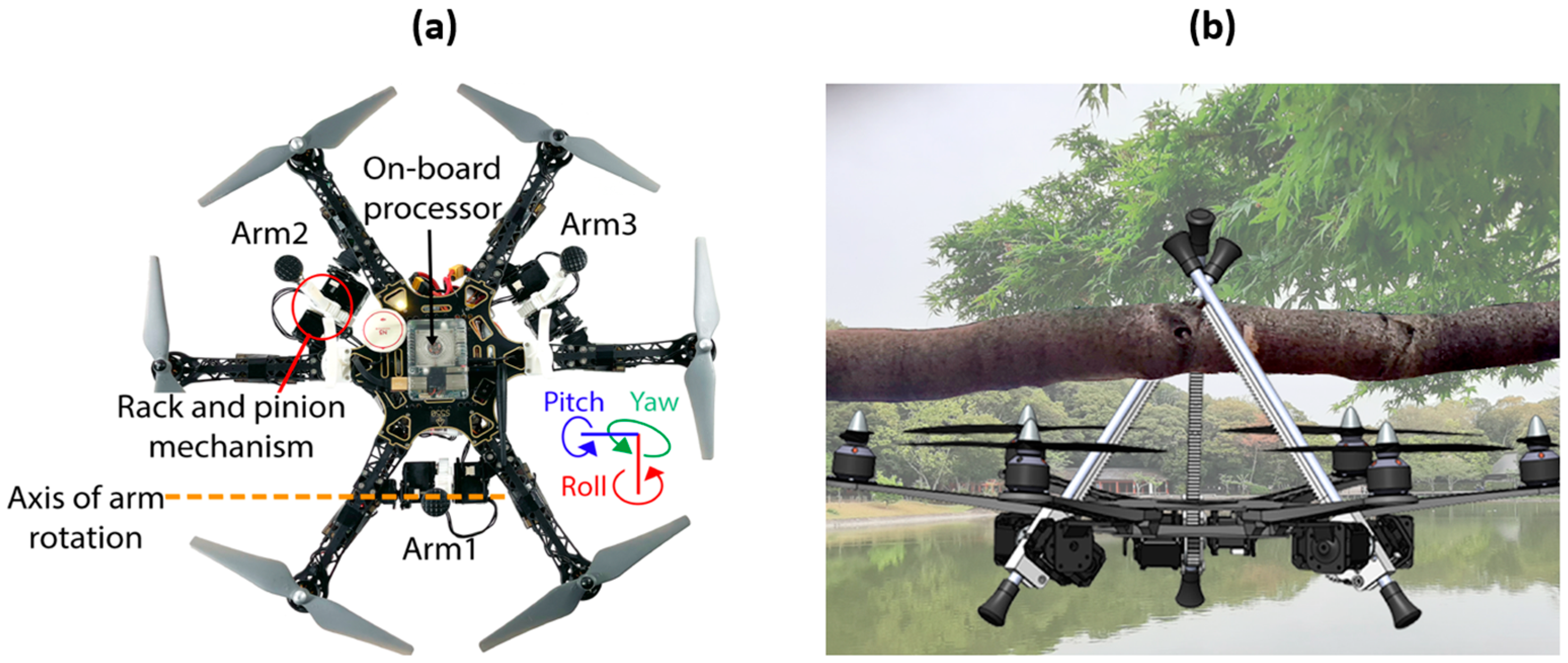
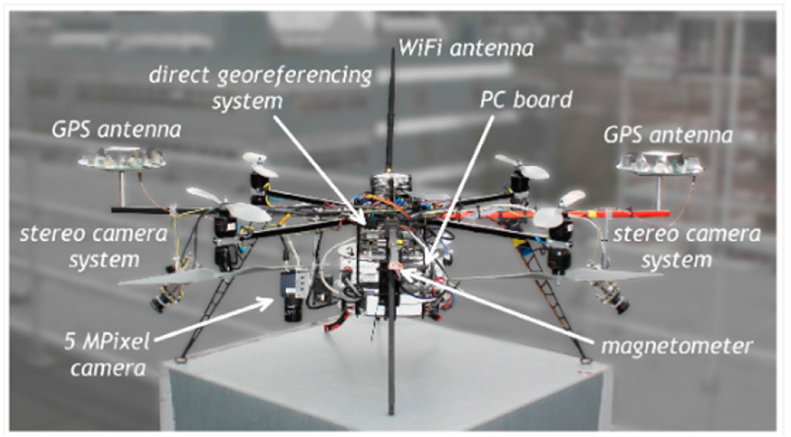
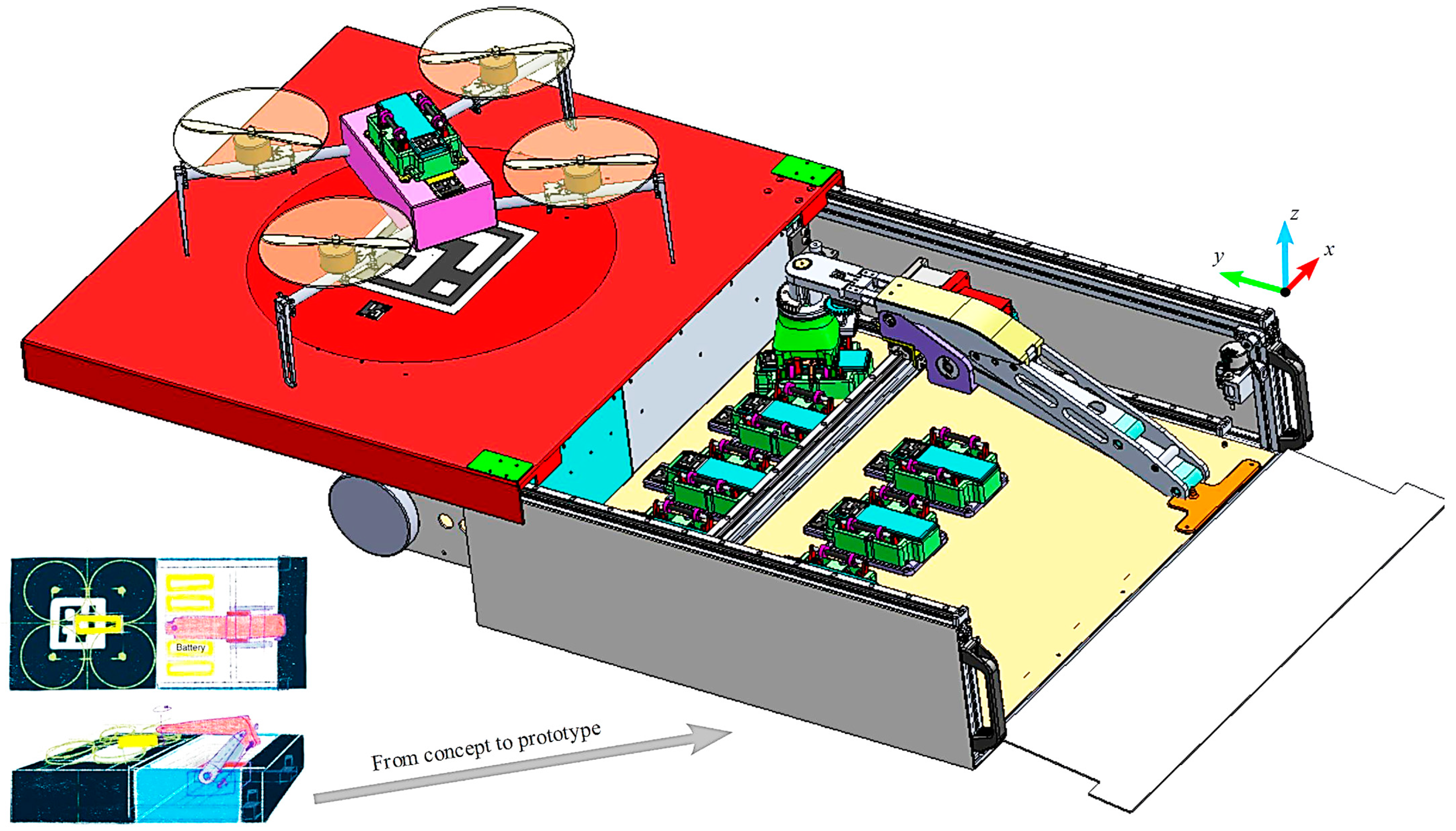
4.1.3. Payload Integration and Control

Depending on the UAV flight mission (i.e., the purpose of the flight), additional equipment (e.g., sensors, packages, etc.), referred to as payload [186], can be embedded with it in order to fulfil its mission’s objectives. In other terms, payload refers to any added weight or equipment to the UAV beyond its essential components for flight. With that being said, a payload can disturb a UAV’s proper flight, representing an external physical trigger for swinging and other forms of physical perturbations [187]. Therefore, payload control aims to operate and control the added weight, thus ensuring a UAV’s stable flight. For that purpose, suspended payload perturbation can be suppressed by means of a Nonlinear Disturbance Observer (NDO)-based neoteric anti-disturbance control strategy [188]. For the case of a cable-suspended payload, the full nonlinear dynamic behavior of a UAV is stabilized through a nonlinear control technique with a repetitive algorithm: reference points are tracked via back-stepping and integral sliding mode control, where the iterative algorithm shuts the error terms down to zero [189]. Similarly, for suspended-load systems, the UAV’s flight is stabilized through a nonlinear controller with the following working mechanism [190]: at each iteration, the UAV’s dynamic model undergoes an approximate linearization (i.e., relying on first order Taylor series expansion) at equilibrium; an H-infinity feedback controller is then designed for the resulting approximately linearized model. This results in fast and accurate tracking of the entire UAV system (incorporating the payload). The stability of the control scheme is justified with Lyapunov analysis [190]. Many other embedded payload solutions in UAVs exist [191]. Hence, it is easier to choose a control technique, where payload control is imperative for all tasks demanding high precision, adaptability, and real-time decision-making, expanding the possibilities for aerial applications.
A UAV control subsystem is diversified in nature, where its main aim is to ensure an effective flight, most importantly with autonomous operation [192]. Regardless of the UAV type (e.g., fixed wing [193], rotary wing [194], etc.) and its corresponding field of application (e.g., surveillance, packet delivery, etc.), its corresponding mission must successfully bypass obstacles and concisely follow the pre-planned path. AI-based navigation strategies excel in the adaptation to dynamic environments as compared to vision-based techniques. On the contrary, vision-based navigation techniques require less training than AI models. From another perspective, multi-fusion and bio-inspired path planning methods demand higher computational facilities than their relatives because of the fact that they involve data integration. As for the localization criteria, VO focuses on incremental changes, while RVL is based on local references and AVL relies on global coordinate systems. Considering target tracking, the reviewed models of the YOLO algorithm present real-time processing and detect objects based on the entire image context, but they still show less tracking ability in complex environments when compared with other specialized algorithms such as Kalman Filter [195], and Deep-SORT [196]. The payload deployment on the final destination cannot be generalized under defined methods or techniques since it is seen that such a criterion mainly depends on the geometry of the load, its weight, its installation/release mechanisms, and other application-specific constraints.

4.2. Computing

In relation to the previous control subsystem, the presented algorithms for a UAV’s navigation (whether vision or AI-based), as well as for path planning, obstacle avoidance, localization, target tracking, and payload deployment, need physical onboard systems for treatment. In other words, the execution of such algorithms is performed through computerized systems inside the UAV, serving as data processing, data logging, and all forms of diagnostics. Additionally, the raw data provided by the onboard sensors, and communication protocols with external parties, are also processed in the computing subsystem. In this context, a UAV’s computing subsystem encompasses two main sets including Single-Board Computers (SBCs) and System on Module (SoM).
(a)
SBCs
As its name indicates, an SBC represents a complete computer that is built on a single circuit board, including a Central Processing Unit (CPU), Random Access Memory (RAM), storage, Input/Output (I/O) interfaces, and other features similar to a functional computer. Because of the fact that SBCs have smaller form factors, they are found to be compact and suitable for usage in space-restricted applications, such as in a UAV [197]. For UAV process management, the most common SBCs are Raspberry Pi, Odroid XU4, and NVIDIA Jetson (nano, TX2, Xavier).
  • Raspberry Pi
Beginning with Raspberry Pi 4, it represents a new Raspberry Pi-based SBC that is increasingly involved in UAVs. This model is powered by a Broadcom BCM2711 quad-core ARM Cortex-A72 processor, which can be clocked at up to 1.5 GHz. It is available with up to 8 GB of Low Power Double Data Rate 4( LPDDR4) RAM, thus providing a stronger ability to deal with a UAV’s multitasking applications. Featuring a VideoCore VI GPU, supporting OpenGL ES 3.x, smoother graphics are rendered, hence better detecting objects and avoiding obstacles in UAV’s path planning. Aside from Universal Serial Bus (USB) and ethernet connectivity, Raspberry Pi 4 presents a built-in dual-band Wireless-Fidelity (Wi-Fi) of 2.4 GHz and 5 GHz, in addition to Bluetooth 5.0, hence presenting flexible communications with UAV remote parties. The storage capacity (e.g., used for video and images records) can be expanded by means of microSD cards, where its 40-pin General Purpose Input–Output (GPIO) facilitates connections to other computing platforms and sensors [198]. In the field of UAV applications, maneuvering was improved when an open source and MAVLink communication were encoded onto a Raspberry Pi 4 onboard SBC with a Pixhawk Cube 2.1 flight controller. This integration is shown in Figure 4 [199].
Figure 4 shows how Raspberry Pi 4 can flexibly make decisions concerning a UAV’s flight by dynamically adapting to different communication protocols with only a few subsystems (e.g., sensors). The data recorded with Raspberry Pi 4, clearly indicates the accuracy in UAV object detection [199]. For an object tracking-based UAV mission, when the Patch Color Group Feature (PCGF) framework was embedded on a Raspberry Pi 4, it resulted in 17 FPS offering a good execution speed with low PCGF computational complexities [200]. Older Raspberry Pi models, such as Raspberry Pi 2 B+, are effective in illustrating the relationship between time constraints of real-time systems and the analysis of temporary computational complexity [201], hence better managing failure possibilities in real-time processes.
  • Odroid XU4
As an alternative to Raspberry Pi as a UAV’s SBC, Odroid XU4 possesses a Samsung Exynos 5422 octa-core processor, consisting of four ARM Cortex-A15 cores, clocked at 2 GHz. The remaining cores consist of ARM Cortex-A7 clocked at 1.4 GHz. This core’s combination provides a trade-off between performance and energy efficiency. This SBC comes loaded with 2 GB of LPDDR3 RAM, which is sufficient for multitasking and general UAV processing applications. Graphics are featured via a Mali-T628 MP6 GPU, thus proving an ability to withstand UAV-based decent graphics (i.e., taken through cameras). In addition to USB and Ethernet communication modules, Odroid XU4 supports Wi-Fi communication via an external USB adapter. Instead of a 40-pin GPIO, as in the case of Raspberry Pi, Odroid XU4 presents a 30-pin GPIO header, hence reflecting lower accommodation with external devices and sensors. One major drawback of this SBC compared with Raspberry Pi is that it produces significant heat under heavy computational loads, hence implying the need for a cooling utility (e.g., fan, heat sink, etc.) and posing more challenges in front of space limitations [202]. The on-board processor shown in Figure 5a represents an Odroid XU4 deployed to provide the motor control operations [203].
For the Odroid XU4 used in the UAV in Figure 5, its docking mechanism (i.e., over a tree branch, as in Figure 5b) is designed by means of a three-arm manipulator, thus allowing for resting periods (for whatever reasons) during its flight. From a different perspective, for visual-based detection as well as tracking cooperative UAVs, Odroid XU4 can embed an algorithmic architecture based on YOLOv2. Computational time and false alarms can hence be reduced through navigation data exploitation from tracker-target UAVs. Over 90% of target line-of-sight were correctly detected and accurately estimated [204].
  • NVIDIA Jetson
NVIDIA Jetson is a series of SBCs designed specifically for embedded applications, presenting a leading AI-compatible platform in a compact and energy efficient form factor. An NVIDIA Jetson SBC includes a dedicated GPU, optimized for parallel computing, sensor fusion, computer vision, etc. As a sub-model, Jetson TX2 represents a supercomputer-on-module with up to 8 GB of LPDDR4 RAM and a dual-core NVIDIA Denver 2 CPU with quad-core ARM Cortex-A57. The NVIDIA Pascal graphics processor with 256 cores represents its GPU, thus allowing for higher visual resolutions [205]. In a drone-based pedestrian tracking process [206], Jetson TX2 enables real-time tracking while effectively addressing challenges relating to computing power limitations. Additionally, it achieves the real-time processing of DL-based object tracking tasks. This is mainly performed with assistance from both CPU as well as GPU integrated within Jetson TX2, showing high efficiency in target tracking based on 4K video streams captured by the UAV at an elevation of 50 m. Another model of NVIDIA Jetson SBCs, Jetson Nano, is found to be capable of embedding an improved version of YOLOv4, the Fast-YOLOv4 [207]. Figure 6 elaborates the conjunction of Jetson Nano with other components of the object detection system.
The main role of the Jetson Nano in Figure 6 (i.e., 128-core CUDA Maxwell GPU, 4 GB LPDDR4 RAM, quad-core ARM A57 1.43 GHz) is the real-time analysis of image data, in addition to sending abnormal results to the workstation through Wi-Fi. The resulting mAP reached 90.62% with a 54 FPS [207]. Table 5 provides a comparative assessment of the different reviewed SBCs used in UAV processes.
(b)
SoM
A SoM reflects an integrated computing platform encompassing the essential component of a computer (e.g., CPU, RAM, storage, etc.) onto a single module, simplifying the build of larger embedded systems. While both SBCs and SoM serve for similar purposes in embedded systems (e.g., flight control of a UAV), they differ in terms of the form factor and design architecture. On one hand, SBCs come packaged with all essential components, which makes them standalone computing systems, thus neglecting any need for additional hardware. A SoM, on the other hand, cannot directly connect to peripherals because it typically does not have I/O sockets [208]. For UAV control, different SoMs can be used such as NXP I.MX8M [209], Rockchip RK3399 [210], Qualcomm Snapdragon [211], and STM32 [212]. Regarding the work in reference [213], NXP I.MX8M provides a custom AI video-processing-focused hardware platform for the deployment of DL models. By integrating a Neural Co-Processing Unit (NCU), it enables the process of 2.3 tera operations per second, hence considerably reducing the processing time for the implemented DL models used in smart cities’ smart-camera-systems. Similarly, in [214], Rockchip RK3399 serves as the SoM for video data (recorded in real time by a UAV) processing, providing more speed and prohibiting delays in video transmission in 5G networks. For the purpose of UAV safety landing in a GPS-denied environment, the work in [215] utilized a “remote-marker-based” tracking algorithm that is implemented on a Qualcomm Snapdragon SoM. The developed CNN “LightDenseYolo” algorithm, by means of an embedded Qualcomm Adreno 540 GPU, extracts features from an input image. This extraction can be used to predict a marker’s location by a visible light camera sensor installed on the UAV. The suggested methodology outperforms state-of-art UAV object trackers [215].
Concerning a different approach than in the previously mentioned works, the work in [216] emphasized monitoring a mobile network (i.e., performing testing and measurements) by means of a UAV through the Galilelo satellite network. The proposed software runs on a Qualcomm Snapdragon SoM (embedded in a Xiaomi mi 10 lite), enabling effective and accurate remote extraction of mobile network data (e.g., signals levels, data logging, information visualization, etc.). The authors of the reference [217] take a different perspective, based on an improved algorithm involving greater immunity versus cyber attacks in the Internet of Drones (IoD) on a Qualcomm Snapdragon SoM. Their results indicate a stubborn protocol with good resistance in front of security attacks of a swarm of drones used for smart city real-time data collection. Alternatively, in reference [218], the aim is to rescue injured humans swiftly by means of mission choice-driven UAV swarm cooperation. After the transfer of a suspected target’s location to a self-organizing network, a bio-radar UAV rechecks for any survivors via a respiratory characteristic-based algorithm that is processed by a STM32 SoM. The data packets sent by the STM32 eventually allow the emergency supplied drop-off by means of a nearby emergency UAV according to the location/vital signs of the target, showing good success and accuracy. Specifically, the STM-based SoM finds various applications in UAV processes. For instance, aside from injured human targeting and help, STM32 succeeds in the analysis of a quadcopter’s stability, first, by reading data of angular velocity and acceleration. Then, by supplying Pulse Width Modulation (PWM) signals to an Electronic Speed Control (ESC), the brushless DC motors are correspondingly regulated, providing more controllability and a reduction in the response time of the UAV [219]. These SoM also find use in human–UAV interactions based on machine learning in wearable gloves [220]. With one STM32, five flex sensors, and one Inertial Measurement Unit (IMU) sensor installed in each glove, gestures are recognized and equivalently translated in a control command for the UAV.
The variety of SoMs that can be employed in a UAV process, as can be concluded from the small survey of the literature presented above, makes their selectivity criterion challenging, especially since each comes with specific pros/cons. Therefore, for an optimal SoM selection, a standard assessment must be conducted in which standard factors, such as programming complexities, communication protocols, form factors, and, most importantly, the UAV’s mission objectives, must be taken into consideration. This required assessment is presented in Table 6. It is worth saying that after analyzing Table 6, it can be concluded that some SoMs may excel in demanding less computational power, while others prioritize power efficiency. For some UAV applications, mainly related to network monitoring, and integration capabilities (i.e., ability to seamlessly communicate with remote parties, sensors, etc.) Qualcomm Snapdragon would be prioritized the most.
The assessment presented in Table 6 adds a straightforward approach to an optimal selection of a SoM in a UAV process. For instance, when the selection is mainly based on the UAV’s flight purpose, on one hand, for aerial surveillance, the Qualcomm Snapdragon can be the best candidate because of its powerful GPU performance (i.e., high-definition real-time video processing). Additionally, its support for 5G connectivity ensures fast data transmission, as required for real-time surveillance. Other UAV missions can involve package delivery, on the other hand. Aside from parcel delivery, emergency kits, medical supplies, and packages can, for example, the payload consists of electrical sensors to be deployed on the overhead electrical transmission lines. Accordingly, such applications would require accurate navigation and good management of the payload’s weight. For such particular applications, Rockchip RK3399 is found to be optimal, according to Table 6. This is mainly because it offers a trade-off between high performance and economic power consumption, hence achieving autonomous navigation while optimizing battery life. For longer missions (e.g., crops assessment and agriculture) that require high real-time processing capabilities, STM32 is found to be the best candidate among the others because its very low power consumption extends the UAV flight’s time, along with its integrated ability for high data collection.

4.3. Communication

Between the UAV and external entities (e.g., Ground Control System (GCS)), a bidirectional data exchange is enabled by means of the communication subsystem. For applications involving a swarm of drones, it also enables mutual communication and data exchange between each UAV, transmitting control commands, captured images, and other data. It might be the case that the computing subsystem processes the data from sensors through the communication subsystem; however, the focus in this paper took into consideration only remote communication with external parties. Based on this approach, the communication modules/protocols were found to include Long Range (LoRa), Wi-Fi, Bluetooth Low Energy (BLE), and Long-Term Evolution for Machine-Type Communication (LTE-M).
(a)
LoRa
LoRa refers to long-range low-power wireless communication technology allowing for telemetry between a UAV and an external party [221]. Its physical layer employs a private Chirp Spread Spectrum (CSS), with LoRaWAN as its MAC layer [222]. Within the framework of UAVs, the identifier of a UAV is transmitted with real-time status tracking through LoRa [223], as well as other data concerning cases of environmental disasters [224]. From a different perspective, LoRa is utilized along with UAV-embedded IoT devices to track merchandise and increase their location accuracy in [225], whereas in [226], LoRa was employed to link a UAV with air pollution monitoring stations. Although LoRa presents the capability to transmit for up to 15 Km in rural areas [227], over unlicensed bands at frequencies ranging from 433 MHz to 923 MHz, it suffers from a low data rate, ranging between 0.3 and 5.5 kilobytes per second (kbps) [228]. This communication technology can be enabled inside a UAV through different modules, for example, SX1278 [229] supporting the frequency range from 137 MHz to 525 MHz. Alternatively, RN2483 [230] can also enable LoRa inside a UAV with a data rate of 300 kbps, similar to HOPERF RFM95W-868S2 [231], which works on a frequency of 868 MHz.
(b)
Wi-Fi
In lieu of LoRa, Wi-Fi enables remote control in UAVs, in addition to real-time data transmission, telemetry with GCS, and communication with other UAVs [232]. Wi-Fi communication in UAVs usually follows the Open System Interconnection (OSI) model, consisting of seven layers [233]. Within the framework of UAVs, the wireless systems’ range (i.e., coverage zone) is extended through an intel Galileo board installed in a UAV, where Wi-Fi is configured in ad hoc mode [234]. A regional inspection and monitoring system based on Wi-Fi is established in reference [235], in which the signal strength model based on the Wi-Fi directional gain antenna is introduced. The leader–follower trajectory scheme in [236], on the other hand, implements a Robot Operating System (ROS) based communication system for a swarm of UAVs via Wi-Fi and MavLink serial forwarding. Tests result in fast responses between workstation–leader and leader–follower communication (0.2 S and 0.42 S, respectively). Unlike LoRa, which is featured by a coverage zone in kilometers, Wi-Fi technology has a limited range (maximum of 300 m outdoors). From another perspective, Wi-Fi presents an elevated throughput data rate, which varies according to each protocol (e.g., 802.11ax, 802.11ac wave2, 802.11ac wave1, 802.11n, 802.11g, 802.11a, 802.11b, [237]). Different modules exist that enable Wi-Fi communication on a UAV, of which ESP8266 [238] enables the SBC/SoM to connect to 2.4 GHz via the 802.11bgn. A better alternative to ESP8266 is ESP32 [239], which presents a Bluetooth connectivity, also featuring a dual-core processor allowing for better multitasking. CC3000 [240] can alternatively add Wi-Fi functionality to a UAV, supporting the 802.11b/g protocol, but, on the other hand, it does not support the AP mode.
(c)
BLE
Representing an enhanced version of Bluetooth, BLE is designed for applications that require short range demands with low power, having the same bit rate, frequency range (i.e., from 2.4 GHz to 2.48 GHz), and range of traditional Bluetooth [241]. In combination with the Received Signal Strength Indicator (RSSI) technique, the BLE-RSSI combined method presented a lack of precision in UAV positioning, which was overcome in [242]. With regard to UAV navigation in GNSS-denied environments, an indoor positioning system for UAVs is set up through BLE beacons by analyzing the RSSI, where the final position estimation is acquired by trilateration [243]. In the catapult launcher of small UAVs in [244], BLE consisted of a positioning feedback system, providing a continuous connection between the user and the control panel. BLE can be added to a UAV through the nRF54H20 System-on-Chip (SoC) which presents multiple ARM Cortex-M33 processors with a 1 MB of RAM, providing a long range with a 10 dBm of transmission power [245]. The nRF54LI5 SoC from the same series, on the other hand, comes with a single 128 MHz Arm Cortex-M33 processor and 256 KB of RAM, with 8 dBm of transmission power [246]. Different from the nRF54-based series, CC2650 [247] represents another medium with which BLE communication can be enabled in a UAV, and it comes equipped with a 20 kB of RAM and up to 31 GPIO ports.
(d)
LTE-M
A low-power, wide-area, cellular-technology-based communication supports machine-to-machine interaction as well as IoT. LTE-M presents a high data rate and an increased bandwidth and can be easily integrated with existing cellular networks [248]. By means of LTE-M, the range of UAV operations can be extended by the supported Beyond Visual Line of Sight (BVLOS) [249]. In [250], the performance of LTE-M was investigated with a UAV for a distance of 450 feet, where 5G communication was found to have better signal strength. To equip UAVs with LTE-M communication, Quectel BG95-M3 LGA [251], on the one hand, presents a good solution featured by an ultra-low power consumption as well as multiple frequency band support. Telit ME310G1-WW [252], on the other hand, adopts another low-power operation by adapting a specific wakeup–transmit–sleep mechanism, also supporting various LTE bands and GNSS technologies.
According to the different surveyed communication technologies that can be employed in a UAV, the choice for a specific module based on communication theory/protocol can be challenging. It is true that all methods share the wireless connectivity criterion, but still, many other factors must be taken into consideration when embedding a communication module in a UAV. Firstly, the range of communication (i.e., coverage zone) reflects a great impact factor, and it can be noticed between LoRa and BLE. Environmental constraints (e.g., signal degradation, deterioration, and complete loss) are another key factor for the choice of the surveyed modules. How to program each module is another topic, since the programming requirement is another decisive factor. LoRa-based modules can cover wide zones with a high bitrate, but their supported frequencies may not intersect with those received in the ground/remote station. LTE-M based modules, on the other hand, possess the greatest bitrate (i.e., optimum for high data exchange) but are heavily dependent on network coverage. Table 7 provides a standardized assessment of each physical module in each of the four main communication sets surveyed (i.e., as much as applicable since some differ intrinsically).

4.4. Sensory

Sensors in UAVs represent the data source for each of the previous main subsets. In other terms, the physical data acquired from different sensors are computed in the decision-making control subsystem and communicated (i.e., when necessary) with other internal/external parties. The level of autonomy in a UAV’s application (i.e., fully autonomous [253], semi-autonomous [254], or human-controlled [255]) majorly depends on the type/number of sensors. For instance, autonomous UAVs are found to be capable of executing missions without human intervention, which is related to their installed wide array of sensors, thus allowing a better understanding of the surrounding environment. Additionally, a popular case is sensor fusion in autonomous UAVs, where combined data improve perception and self-decision-making [256]. Manually controlled UAVs, on the other hand, have minimal sensor payloads since they follow a human-determined path where their embedded sensors are mainly for emergency cases (i.e., electric power dropouts, etc.). Here, the surveyed sensors that can be installed onboard UAVs are mainly classified as either environmental, vision, or position sensors, as shown in Figure 7.
  • Environmental sensors
(a)
Pressure sensors
A UAV’s flight control and navigation are affected by the data provided by the environmental sensors, such as temperature, humidity, and pressure. For instance, safe flight levels are maintained via the altitude information provided by the pressure sensors. Altitude measurements are generally challenging to obtain, especially because of vibrations and fast-changing environmental conditions. In [257], these challenges were first addressed by focusing on the UAV’s vertical movement measurements. The altitude was finally determined via the data obtained from the barometric pressure sensor MS5611, fused with other data from an ultrasonic sensor. MS5611 is a high-resolution barometric pressure sensor (24-bit Analog to Digital Conversion (ADC)), with a pressure accuracy of ±1.5 mbar and an operating range from 10 to 1200 mbar [258]. Another digital pressure sensor, BMP388, can also be UAV-embedded with a less sensitive operation range between 300 and 1250 mbar and has a typical relative accuracy of ±0.08 mbar [259]. This BMP388 finds application in UAV automative radar for earth/land monitoring processes [260].
(b)
Temperature sensors
Apart from pressure sensors, temperature sensors help in the monitoring processes of ambient conditions. Thus, they ensure an optimal performance of onboard electronics as well as propulsion systems by declaring fault signals in the case of over-/underheating conditions. On the one hand, DHT11 (combined temperature and humidity sensor) collects corresponding environmental data from a specific location, which is dedicated to being sent to a webserver for remote monitoring [261]. Other temperature sensors, such as the one in reference [262], are used for calibrating the grey in the photos taken from thermal cameras. In [263], on the other hand, temperature sensors were found to be (in addition to other sensors) effective in soil monitoring and the proper management of crops.
(c)
Humidity sensors
Similar to the work in [261], the combined temperature–humidity DHT11 sensor was used in [264,265] to create an efficient IoT-based weather station. As an alternative to DHT11, SHT75 [266], representing a digital pin-type humidity sensor with ±1.8% typical relative humidity accuracy, was used in [267] to measure air humidity for the purpose of constructing an intelligent weather station. From a different point of view, SHT40 in [268] participated in the construction of pressure–temperature–humidity probes for distributed atmospheric monitoring via a UAV. Lastly, a relative humidity sensor was employed in [269] as a sub-component from a massive project aimed at monitoring the temperature and humidity in Antarctica.
It can be generally deduced that humidity sensors help to ensure a stable UAV flight by preventing condensation-related problems. The synergistic operation of the three environmental sensors enhances a UAV’s situational awareness, hence allowing a dynamic accommodability to changing environmental conditions. Additionally, environmental sensors can have external duties that are not related to UAV navigation and flight safety, mainly as contributions to effective weather stations, as stated in the survey of the literature stated above.
  • Vision sensors
Different from environmental sensors, vision-based sensors provide a visual perception of a UAV’s surrounding environment by generating an image of the captured scene. The processed image is then forwarded to its relevant computing subsystem in order to make a decision based on it in the control subsystem. For example, the raw version of the obtained image can be processed through any of the SBCs (e.g., Odroid XU4, NVIDIA Jetson), where, by means of the YOLOvx navigation control algorithm, targets can be efficiently tracked while obstacles avoided. Two of the most used vision-based sensors in UAVs are RGB-D and thermal cameras.
(a)
RGB-D Cameras
An RGB-D camera provides a perception (i.e., closely related to human visual perception) of a UAV’s surroundings in the form of RedGreenBlue (RGB) images. As previously mentioned, targets can be tracked, and the UAV’s localization can be acknowledged upon the processing of RGB images to computer vision algorithms through SBCs/SoM. Spatial distances of targets can also be calculated via the RGB images’ depth information, thus providing better collision avoidance strategies. Overall, such a camera’s quality is assessed from its frame rate, aperture, and shutter type [270]. One type of RGB-D camera is the Intel Realsense D435 [271], which was found to be ideal for fast moving applications in low light and a wide field of view. It has an RGB frame rate of 30 FPS and an RGB frame resolution of 1920 x 1080. Intel Realsense D435 was used in reference [272] to collect depth measurements in order to identify the parameters of the depth camera noise model, thus enabling more accurate SLAM algorithm execution. RGB-D cameras can also be involved in 3D mapping to describe a UAV’s surroundings after SLAM fusion with a UAV [273].
(b)
Thermal Cameras
A thermal camera is an equipment that captures and detects Infrared Radiation (IR) emitted by surrounding objects. This type of camera allows for imaging based on heat, which can be used for aerial surveillance, environment monitoring, and search–rescue processes [274]. Thermal cameras find applications in different UAV processes, such as the bridge infrastructure assessment shown in Figure 8.
As shown in Figure 8, a bridge’s infrastructure non-destructive testing by means of a UAV saves time and gives more accurate and faster results than visual inspection. The actual captured image of the bridge (Figure 8, bottom left) is reflected in an equivalent thermal image (Figure 8, bottom right), revealing the cohesion between different parts of the bridge.
  • Position sensors
UAV movements are detected via position sensors, where the latter provide spatial information with respect to a defined reference. Such sensors are generally used in UAVs to pinpoint their precise location in order to later share it with the user/control operator (for cases of semi-autonomous and human-controlled UAVs) or to compute it in the navigation control (for cases of autonomous UAVs). Therefore, position sensors determine the orientation of a UAV in addition to providing odometric information about it [276]. In this paper, position sensors are mainly classified according to their purpose of usage/outcome, characterized as either tracking/localization or proximity/radar.
(a)
Tracking/localization
The localization-based navigation strategy as well as the target tracking scheme under the control section obtain their inputs from sensors such as GPS, IMU, and Ultra-Wide Band (UWB) [277]. On one hand, GPS sensors provide accurate time–space information for UAVs. Specifically, the Real-Time Kinematic (RTK) GPS technique provides positioning updates with high frequency and is thus able to withstand a UAV’s swift velocities and high maneuverability [278]. For instance, a high-precision RTK GPS was used in [279] for the purpose of determining the locations of a ground control target. In addition to localization, GPS modules embedded in UAVs provide temporal information, which can also be used for stabilization. The u-blox NEO-M8N [280] representing a low-power compact form GPS receiver, was used in [281] to solve the problem of wind gusts with their adverse effects on UAV steering while inspecting transmission lines. On the other hand, IMUs are most probably found in UAVs in the form of accelerometers, gyroscopes, and magnetometers [282]. Along with GPS modules, IMUs form INS, which is responsible for localizing, stabilizing, and tracking a UAV. In the work [283], with its UAV shown in Figure 9, the corresponding IMU (i.e., GPS antenna, magnetometer) had the function of attitude determination, localization, and navigation of a UAV.
In addition to the GPS and IMU modules, UWB sensors utilize pulses of short-range radio frequency to determine the location of nearby objects. The location of a target is known when the UWB receiver receives (according to a specific frequency spectrum) the corresponding pulses sent by the UWB transmitter [284]. For positioning, UWB utilizes either the time difference of arrival approach [285] or the two-way ranging method [286]. DWM1000 [287] is a commonly used UWB transceiver module, supporting four radio frequencies from 3.5 GHz to 6.5 GHz, with a data rate up to 6.8 Mbps. In the work [288], the DWM1000 orchestrated ranging measurements between a UAV and fixed anchor nodes, eventually localizing the UAV precisely. This suggests how UWB can help in positioning UAVs in GPS-challenging environments.
(b)
Proximity/radar
In short, proximity sensors provide spatial information with respect to objects existing nearby in their field (i.e., detecting objects in short ranges via IR and other ultrasonic technologies). Radar sensors, on the other hand, use radio waves to detect objects located at greater distances than those in the previous case. Concerning ultrasonic proximity sensors, HC-SR04 [289] provides from 2 cm to 400 cm of non-contact distance measurements with an accuracy of ± 3 mm. Such a sensor was used in reference [290] to detect nearby objects of an indoor UAV. As an alternative, MaxSonar MB1222 [291], with a higher range in object-detection than the previously mentioned sensor (i.e., 20 cm to 765 cm), finds application in indoor localization of micro-UAV, with accurate performance [292]. From a different perspective, mmWave radar sensors provide accurate target range and velocity information, surpassing the other alternatives under extreme weather conditions [293]. One example is IWR6843, which provides a range of detection of 180 m and an ± 120 elevation field of view [294]. At the final destination, and although LiDAR mainly aims at generating 3D maps of the environment (via analysis of the reflect light from emitted laser pulses), it can as well be utilized for UAV positioning (e.g., providing precise measurements of a UAV’s altitude above ground level [295]). For instance, Livox-avia [296] represents a LiDAR sensor with a 450 m maximum detection range. This sensor was used in reference [297], in which a UAV’s real-time positions were identified based on the utilization of it with RGB-D cameras (i.e., visual-LiDAR fusion).
Amongst the different reviewed UAV sensor types, environmental sensors (i.e., measuring temperature, humidity, and pressure) possess an additional role (to data sharing) in ensuring flight safety. For example, a UAV flight can be urgently terminated or have its span-reduced under excessive rain or humidity. On the other hand, vision-based sensors serve primarily for data extraction. The captured visual information aids in navigation tasks by detecting objects and avoiding collision with them. Regarding a UAV’s position sensors, they directly enable accurate control via the information about the UAV’s position, velocity, and orientation. Regardless of the sensor type, the more embedded sensors are within a UAV, the better its accuracy in maintaining a safe autonomous flight.

4.5. Power

As can be seen in Figure 1, the power subsystem is the most critical amongst all the others, representing the operating fuel for every SBCs, SoM, communication, and each sensory module. A UAV’s flight pace and duration are mainly dictated by the offered energy level from the power subsystem. In order to successfully overcome limited flight endurance, the power system must be carefully chosen, mainly based on the UAV’s purpose of flight. For example, a search-and-rescue UAV requires more power than the one used to assess public infrastructure since the first often interacts with spontaneous incidences of high risks. Generally, the power source of a UAV must be chosen according to its durability, it must have a good energy to weight ratio and create as minimum noise and vibrations as possible, and it must be easily replaced. Conventionally, UAVs are powered with batteries, battery hybrids with proton membrane fuel cell, gasoline engines, hydrogen fuel cells hybrid with Lithium-Ion batteries (Li-I), and solar power.
Beginning with the work in [298], a 14 kg UAV had a power of 960 W supplied from a hybrid system, which was composed of a proton-exchange membrane fuel cell (as the main supply) and a Li-I (as a backup). This power-source mixture took advantage of the fuel cells fast refueling and ability to supply power for long distance ranges, in addition to the Li-I high acceleration and fast response to load variations. Such a power scheme, however, may present concerns regarding its longevity under frequent charging/discharging of the Li-I. An alternative way to overcome the UAV’s battery capacity issue and the need for its frequent charging is Droneport [299]. It consists of a landing platform, over which the UAV can have its battery exchanged and charged outside of its frame. As an alternative to hybridization with other-than-battery power sources, Droneport represents a complete electromechanical system, as shown in Figure 10, enriching the capabilities of UAVs with existing batteries power sources.
Unlike the study in [298], the work in [300] suggested a hybridization between gasoline and electric motors: two gasoline motors supplied the majority of the power needed for the lift force, with four electric motors utilized to stabilize the drone. Since the propellers consume the majority of the power within a UAV, the suggested gasoline–electric hybrid method prolongs a UAV’s flight time. Apart from gasoline, electric, and hybrid power sources, UAVs can be solar powered. In reference [301], a 2 m wingspan UAV was powered through a combination of solar PhotoVoltaic (PV)-based power and a battery. Under fair weather conditions, the solar–battery hybrid system saved up to 22.5% of the battery stored capacity.
Solar-based power supplies for UAVs are generally inconsistent since they mainly depend on solar irradiance, which can be very fluctuant. Even during sunny days, cloud-induced Partial Shading Conditions (PSCs) [302] impose great challenges in extracting the maximum available power from PV modules. Gasoline-based power strategies, on the other hand, induce fire hazards and higher maintenance requirements, regardless of the extended flight capabilities. Modern research in Li-I optimization would constitute an optimum alternative for traditional as well as hybrid UAV power sources, concerning weight restrictions, explosiveness, extended Depth of Discharge (DoD), and other factors [303].

5. Discussion

This complete review consisted concretely of 202 total references (since some references are only exemplary/explanatory) of which there were 101 references (50%) for the control subsystem, 41 references (20.3%) for sensory, 32 references (15.84%) for the communication subsystem, 24 references (11.88%) for the computing subsystem, and 4 references (1.98%) for the power subsystem. Under the control subsystem, there were 39 references for strategy techniques (38.62% of the total references, particularly within this set), 9 references (8.91%) for path planning/obstacles avoidance, 14 references (13.86%) for localization schemes, 28 references (27.72%) for target tracking, and 11 references (10.89%) for payload integration and control. Concerning the computing subsystem, 11 references (45.83% of the total, particularly within this set) were dedicated to SBCs, whereas 13 references (54.17%) were for SoM. For the communication subsystem, 11 references (34.37% of total references, particularly within this set) were for LoRa, 9 references (28.13%) for Wi-Fi, 7 references (21.87%) for BLE, and 5 references (15.63%) for LTE-M. In the sensory subsystem, 13 references (31.70% of total references, particularly within this set) were for environmental sensors, 6 references (14.64%) for vision sensors, and 22 references (53.66%) for position sensors. Lastly, four different power sources were classified in the final power subsystem, with each referring to a single reference (25% of total references, particularly within this set). This information is shown in Figure 11.
Most of the reviewed references refer to different control strategies, since such criteria are directly linked to overall flight stability and success. The employed algorithms for navigation, target tracking, localization, and obstacle avoidance represent the backbone that output modules (i.e., actuators) rely on, in relation with the data acquired through the sensors. Beginning with the vision-based navigation strategies, they pose a challenge on the computing subsystem, specifically concerning the GPU, in order to fully extract the graphical potential behind such strategies (i.e., high-resolution images with precise BRF), an SBC with high GPU capability (e.g., NVIDIA Jetson series) must be employed. In addition to financial burdens, the processing of image-based data incorporates extra programming complexities that are also naturally accumulated by AI-based techniques. The good part of the latter is that they allow for more autonomous UAV processes.
In the context of target tracking, the YOLO algorithm with its relative successors (i.e., up to YOLOv8), have shown popularity in adaptation for computing an object’s correlative and class probabilities. With every new version of YOLO comes major improvements in terms of knowledge accuracy with respect to its predecessors. For the part of the computing subsystem, the Qualcomm Snapdragon showed superiority with respect to all other SoM/SBCs, mainly regarding its RAM size, integrated GPU, built-in connectivity modules, and ability to be programmed in different languages. From another perspective, according to the data presented in Table 7, LoRa technology is the optimum selection for UAV flights requiring long range of communication (up to 20 km outdoors), with the highest data rate (up to 300 kbps). However, a trade-off must be made between its RAM size and transmission power to better fit an application (i.e., the 32 kB of RN2483 imposes a loss of 2 dBm in the transmission power). The golden rule concerning the sensory part corresponds to the following: the more sensors installed in a UAV, the better its environmental/internal awareness, and the more burden is then created on the level of the computing subsystem. Some sensors, such as temperature sensors, are unavoidable since their output data is highly influential on flight safety and stability. Sensors can also be fused together (i.e., sensor fusion) to provide better decision-making in the control subsystem, as a result of the data-dense outputs. Regardless of the different available power sources for UAVs, as surveyed in this paper, classic batteries are still the best form. For instance, Droneport is an innovative idea, but it lacks experimental validation under severe operating conditions, and it serves only in recharging/replacing a UAV’s existing battery. With the stated unreliability of PV supplies and dangers of gasoline motors, the optimum UAV power supply is an optimized Li-I battery [304]. In comparison with other UAV reviews, the contributions of this paper are shown in Table 8.
In addition to the compared literature presented in Table 8, more narrow reviews exist in the field, but they are denser in the sense of the exploited UAV aspects. For example, the dedicated review in reference [311] focuses mainly on the control of hybrid and convertible UAVs. With a technical modus operandi, emphasizing around vertical takeoff and landing (VTOL) UAVs, the presented review investigates commonalities and differences in guidance, modeling, and control allocation for each type (e.g., Tail-sitter, Tiltrotor, etc.) of hybrid VTOL UAVs. Unlike the methodology presented in this work concerning the control assessment, the work in [311] outlined four main components of a successful flight control system for VTOL UAVs, depicted by a physical model, generation of reference trajectories, flight controllers, and allocation of actuator control. Additionally, the work in reference [312] outlines a UAV-type addressed review, with a core focus on flight modeling techniques, along with flight control strategies. The review began by assessing the flight’s success for different miniature UAVs based on the control techniques. Moreover, further analyses were conducted based on the mechanical structure of the UAV and its corresponding control feature (e.g., tail-sitters with hovering control). As a major observation, the work conducted in [311,312] sheds light on the differences between their control sets and the one held in this paper. Accordingly, it can be said that despite the various contributions made by this paper, it still lacks many criteria in the domain of UAVs. The popularity of this trend, and its daily considerations and improvements, makes it impractical to grasp the required avionics information in one single paper. For this reason, and in order to remain within this paper’s maximum limits (in word counts as well in page numbers), this study did not survey any related manuscripts about the UAV mission field of application (i.e., no thorough investigations about surveillance, crop assessment, delivery, and other UAV’s missions). In addition, when reviewing the different aspects in this paper, it can be noted that a discussion was not provided on UAV type. Additionally, although this paper presents a wide variety of data processors (i.e., SBCs, SoM), no microcontrollers (e.g., Arduino, PIC, etc.) were involved in the analysis since not all missions require heavy computational facilities. For the sensors, this paper did not present any single mechanical or electrical sensor, which are heavily required and employed in UAVs; instead, the focus was merely on environmental, vision, and position sensors. Again, this was mainly because of the paper’s length restrictions and to maintain a readable review format.

6. Future Work

In accordance with the review conducted in this manuscript, the Digitalisierte, rechtssichere und emissionsarme flugmobile Inspektion und Netzdatenerfassung mit automatisierten Drohnen (DNeD) project reflects an actual project that coincides with the concluded information [313]. DNeD aims to design an autonomous UAV that is able to inspect overhead Transmission Lines (TL) automatically and maneuver around them at a safe distance. The UAV should independently plan and execute the approach of flight/landing under prevailing conditions (e.g., cable routing). The UAV’s mission is to deploy its embedded sensor box on the transmission line. The sensor box in turn (i.e., payload) should allow for the remote monitoring of the electrical measurements (i.e., current and voltage) of the line. The data acquired from the TL, non-invasively by means of the deployed sensor box shown in Figure 12, should be intelligently able to be processed and visualized by a human operator at any time.
With the provided DNeD project’s description, this review serves as a straightforward informative background, allowing for the full realization of such a project. According to the investigated information in this paper, the DNeD can be decomposed into two major objects of research as follows: first, the drone with its relative avionics (SBCs/SoM with the correspondent sensors, communication/power modules, and algorithms for data processing). Second, the sensor box, constituting the payload with its total weight and architecture, as shown in Figure 12, and how it can affect the UAV’s flight path. The UAV’s full autonomy and obstacle (i.e., in this case, the TL) avoidance can be covered by the control subsystem reviewed in this manuscript: it is worthwhile to try the YOLOv8 algorithm in a powerful GPU-embedded SBC (e.g., NVIDIA Jetson) in order to detect the presence of a TL such that the UAV’s localization can be achieved through a set of georeferenced images, captured via an embedded camera. The entire UAV can be Li-I powered, with LoRa-enabled communication modules installed, mainly because of signals degradation near TL. In this case, the payload will be the sensor box, which is far from regular applications such as package delivery or military applications. This payload will have its boundaries set with an appropriate material type (i.e., electromagnetic permeability, rigidness, etc.) to ensure the stable remote monitoring of TL. Overall, the execution of the DNeD project with respect to the information provided in this manuscript is a worthy future project.

7. Conclusions

UAVs are complex electromechanical systems, rapidly evolving, and applicable in various fields. They represent a closed-loop interactive platform with five major subsystems (as concluded by this paper). For a stable UAV mission, each of the reviewed subsystems must be carefully engineered to fit at best compatibility with other subsystems. The overall findings can be compressed into one sequential mechanism: the control subsystem is the main decision-maker concerning the flight path (i.e., navigation), flight safety (i.e., collision avoidance), and flight mission (i.e., payload integration). The data input for the control subsystem is fed through the UAV-installed sensors (i.e., environmental, vision, position), and processed via the computing subsystem (i.e., SBCs, SoM). When needed, data can be externally communicated via single/multi communication modules (i.e., LoRa, BLE, Wi-Fi, LTE-M). The power subsystem eventually supplies the required energy of each of the subsystems. The choice of physical devices in each of the subsystems is a real challenge, which is mainly dependent on a UAV’s flight purpose.
Specifically concerning TL monitoring applications (e.g., the DNeD project), with an electrical sensor as the payload, the SBC is at best NVIDIA Jetson series-based (i.e., powerful GPU for TL identification/detection). LoRa-based communication modules, on the other hand (e.g., RN2483), would provide a good signal transmission with regard to electrical/magnetic noise emitted around the TL. An optimized Li-I would represent an optimum trade-off between safety and flight endurance. The sensor box itself is the required sensing equipment for TL monitoring/non-invasive measurements.
Eventually, the presented concrete lists of reviewed UAV’s avionics (i.e., ARM-based SoM, ARM/Samsung-based SBCs, LoRa modules (SX1278, HOPERF RFM95W-86852, etc.), BLE modules (nRF54H20, CC2650, etc.), sensors, power supplies, etc., make this review a handy tool for the hardware design of any other UAV mission purposes.

Author Contributions

Writing—original draft and conceptualization, K.O.; review, editing, and supervision, D.S. All authors have read and agreed to the published version of the manuscript.

Funding

This research paper is part of the project DNeD (“Digitalisierte, rechtssichere und emissionsarme flugmobile Inspektion und Netzdatenerfassung mit automatisierten Drohnen”, engl. “Digitalised, legally safe and low-emission airborne inspection and grid data acquisition using automated drones”) and was funded by dtec.bw—Digitalization and Technology Research Center of the Bundeswehr. dtec.bw is funded by the European Union—NextGenerationEU.

Institutional Review Board Statement

Not applicable.

Informed Consent Statement

Not applicable.

Data Availability Statement

The data are unavailable due to privacy or ethical restrictions.

Conflicts of Interest

The authors declare no conflicts of interest.

References

  1. Capener, A.M.; Sowby, R.B.; Williams, G.P. Pathways to Enhancing Analysis of Irrigation by Remote Sensing (AIRS) in Urban Settings. Sustainability 2023, 15, 12676. [Google Scholar] [CrossRef]
  2. Fragassa, C.; Vitali, G.; Emmi, L.; Arru, M. A New Procedure for Combining UAV-Based Imagery and Machine Learning in Precision Agriculture. Sustainability 2023, 15, 998. [Google Scholar] [CrossRef]
  3. Guan, S.; Takahashi, K.; Watanabe, S.; Tanaka, K. Unmanned Aerial Vehicle-Based Techniques for Monitoring and Prevention of Invasive Apple Snails (Pomacea canaliculata) in Rice Paddy Fields. Agriculture 2024, 14, 299. [Google Scholar] [CrossRef]
  4. Finigian, M.; Kavounas, P.A.; Ho, I.; Smith, C.C.; Witusik, A.; Hopwood, A.; Avent, C.; Ragasa, B.; Roth, B. Design and Flight Test of a Tube-Launched Unmanned Aerial Vehicle. Aerospace 2024, 11, 133. [Google Scholar] [CrossRef]
  5. Wang, Y.; Kumar, L.; Raja, V.; AL-bonsrulah, H.A.Z.; Kulandaiyappan, N.K.; Amirtharaj Tharmendra, A.; Marimuthu, N.; Al-Bahrani, M. Design and Innovative Integrated Engineering Approaches Based Investigation of Hybrid Renewable Energized Drone for Long Endurance Applications. Sustainability 2022, 14, 16173. [Google Scholar] [CrossRef]
  6. Alsumayt, A.; El-Haggar, N.; Amouri, L.; Alfawaer, Z.M.; Aljameel, S.S. Smart Flood Detection with AI and Blockchain Integration in Saudi Arabia Using Drones. Sensors 2023, 23, 5148. [Google Scholar] [CrossRef]
  7. Atanasov, A.Z.; Evstatiev, B.I.; Vladut, V.N.; Biris, S.-S. A Novel Algorithm to Detect White Flowering Honey Trees in Mixed Forest Ecosystems Using UAV-Based RGB Imaging. AgriEngineering 2024, 6, 95–112. [Google Scholar] [CrossRef]
  8. Povlsen, P.; Bruhn, D.; Durdevic, P.; Arroyo, D.O.; Pertoldi, C. Using YOLO Object Detection to Identify Hare and Roe Deer in Thermal Aerial Video Footage—Possible Future Applications in Real-Time Automatic Drone Surveillance and Wildlife Monitoring. Drones 2024, 8, 2. [Google Scholar] [CrossRef]
  9. Kabir, H.; Tham, M.-L.; Chang, Y.C.; Chow, C.-O.; Owada, Y. Mobility-Aware Resource Allocation in IoRT Network for Post-Disaster Communications with Parameterized Reinforcement Learning. Sensors 2023, 23, 6448. [Google Scholar] [CrossRef]
  10. Shin, H.; Kim, J.; Kim, K.; Lee, S. Empirical Case Study on Applying Artificial Intelligence and Unmanned Aerial Vehicles for the Efficient Visual Inspection of Residential Buildings. Buildings 2023, 13, 2754. [Google Scholar] [CrossRef]
  11. da Silva, Y.M.R.; Andrade, F.A.A.; Sousa, L.; de Castro, G.G.R.; Dias, J.T.; Berger, G.; Lima, J.; Pinto, M.F. Computer Vision Based Path Following for Autonomous Unmanned Aerial Systems in Unburied Pipeline Onshore Inspection. Drones 2022, 6, 410. [Google Scholar] [CrossRef]
  12. Kim, H.-J.; Kim, J.-Y.; Kim, J.-W.; Kim, S.-K.; Na, W.S. Unmanned Aerial Vehicle-Based Automated Path Generation of Rollers for Smart Construction. Electronics 2024, 13, 138. [Google Scholar] [CrossRef]
  13. Rossini, M.; Garzonio, R.; Panigada, C.; Tagliabue, G.; Bramati, G.; Vezzoli, G.; Cogliati, S.; Colombo, R.; Di Mauro, B. Mapping Surface Features of an Alpine Glacier through Multispectral and Thermal Drone Surveys. Remote Sens. 2023, 15, 3429. [Google Scholar] [CrossRef]
  14. Han, D.; Lee, S.B.; Song, M.; Cho, J.S. Change Detection in Unmanned Aerial Vehicle Images for Progress Monitoring of Road Construction. Buildings 2021, 11, 150. [Google Scholar] [CrossRef]
  15. Li, R.; Wu, M. Revealing Urban Color Patterns via Drone Aerial Photography—A Case Study in Urban Hangzhou, China. Buildings 2024, 14, 546. [Google Scholar] [CrossRef]
  16. Wu, H.; Huang, Z.; Zheng, W.; Bai, X.; Sun, L.; Pu, M. SSGAM-Net: A Hybrid Semi-Supervised and Supervised Network for Robust Semantic Segmentation Based on Drone LiDAR Data. Remote Sens. 2024, 16, 92. [Google Scholar] [CrossRef]
  17. Yoo, H.-J.; Kim, H.; Kang, T.-S.; Kim, K.-H.; Bang, K.-Y.; Kim, J.-B.; Park, M.-S. Prediction of Beach Sand Particle Size Based on Artificial Intelligence Technology Using Low-Altitude Drone Images. J. Mar. Sci. Eng. 2024, 12, 172. [Google Scholar] [CrossRef]
  18. Koulianos, A.; Litke, A. Blockchain Technology for Secure Communication and Formation Control in Smart Drone Swarms. Future Internet 2023, 15, 344. [Google Scholar] [CrossRef]
  19. Myers, R.J.; Perera, S.M.; McLewee, G.; Huang, D.; Song, H. Multi-Beam Beamforming-Based ML Algorithm to Optimize the Routing of Drone Swarms. Drones 2024, 8, 57. [Google Scholar] [CrossRef]
  20. Abdelmaboud, A. The Internet of Drones: Requirements, Taxonomy, Recent Advances, and Challenges of Research Trends. Sensors 2021, 21, 5718. [Google Scholar] [CrossRef]
  21. Hou, D.; Su, Q.; Song, Y.; Yin, Y. Research on Drone Fault Detection Based on Failure Mode Databases. Drones 2023, 7, 486. [Google Scholar] [CrossRef]
  22. Puchalski, R.; Giernacki, W. UAV Fault Detection Methods, State-of-the-Art. Drones 2022, 6, 330. [Google Scholar] [CrossRef]
  23. Kim, H.; Chae, H.; Kwon, S.; Lee, S. Optimization of Deep Learning Parameters for Magneto-Impedance Sensor in Metal Detection and Classification. Sensors 2023, 23, 9259. [Google Scholar] [CrossRef] [PubMed]
  24. Zheng, Q.; Tian, X.; Yu, Z.; Ding, Y.; Elhanashi, A.; Saponara, S.; Kpalma, K. MobileRaT: A Lightweight Radio Transformer Method for Automatic Modulation Classification in Drone Communication Systems. Drones 2023, 7, 596. [Google Scholar] [CrossRef]
  25. Hyun, D.; Han, J.; Hong, S. Power Management Strategy of Hybrid Fuel Cell Drones for Flight Performance Improvement Based on Various Algorithms. Energies 2023, 16, 8001. [Google Scholar] [CrossRef]
  26. Beliaev, V.; Kunicina, N.; Ziravecka, A.; Bisenieks, M.; Grants, R.; Patlins, A. Development of Adaptive Control System for Aerial Vehicles. Appl. Sci. 2023, 13, 12940. [Google Scholar] [CrossRef]
  27. Bond, E.; Crowther, B.; Parslew, B. The Rise Of High-Performance Multi-Rotor Unmanned Aerial Vehicles—How worried should we be? In Proceedings of the 2019 Workshop on Research, Education and Development of Unmanned Aerial Systems (RED UAS), Cranfield, UK, 25–27 November 2019; pp. 177–184. [Google Scholar] [CrossRef]
  28. Ghazali, M.H.M.; Rahiman, W.; Novaliendry, D.; Risfendra. Automated Drone Fault Detection Approach in Thrust Mode State. In Proceedings of the 2023 IEEE International Conference on Automatic Control and Intelligent Systems (I2CACIS), Shah Alam, Malaysia, 17 June 2023; pp. 17–21. [Google Scholar] [CrossRef]
  29. Dalwadi, N.; Deb, D.; Ozana, S. Rotor Failure Compensation in a Biplane Quadrotor Based on Virtual Deflection. Drones 2022, 6, 176. [Google Scholar] [CrossRef]
  30. Shin, Y.-H.; Kim, D.; Son, S.; Ham, J.-W.; Oh, K.-Y. Vibration Isolation of a Surveillance System Equipped in a Drone with Mode Decoupling. Appl. Sci. 2021, 11, 1961. [Google Scholar] [CrossRef]
  31. Eskandaripour, H.; Boldsaikhan, E. Last-Mile Drone Delivery: Past, Present, and Future. Drones 2023, 7, 77. [Google Scholar] [CrossRef]
  32. Al-Haddad, L.A.; Jaber, A.A. An Intelligent Fault Diagnosis Approach for Multirotor UAVs Based on Deep Neural Network of Multi-Resolution Transform Features. Drones 2023, 7, 82. [Google Scholar] [CrossRef]
  33. Meng, L.; Zhang, L.; Yang, L.; Yang, W. A GPS-Adaptive Spoofing Detection Method for the Small UAV Cluster. Drones 2023, 7, 461. [Google Scholar] [CrossRef]
  34. Arafat, M.Y.; Alam, M.M.; Moh, S. Vision-Based Navigation Techniques for Unmanned Aerial Vehicles: Review and Challenges. Drones 2023, 7, 89. [Google Scholar] [CrossRef]
  35. Fakhraian, E.; Semanjski, I.; Semanjski, S.; Aghezzaf, E.-H. Towards Safe and Efficient Unmanned Aircraft System Operations: Literature Review of Digital Twins’ Applications and European Union Regulatory Compliance. Drones 2023, 7, 478. [Google Scholar] [CrossRef]
  36. Wang, C.-N.; Yang, F.-C.; Vo, N.T.M.; Nguyen, V.T.T. Wireless Communications for Data Security: Efficiency Assessment of Cybersecurity Industry—A Promising Application for UAVs. Drones 2022, 6, 363. [Google Scholar] [CrossRef]
  37. Guo, K.; Liu, L.; Shi, S.; Liu, D.; Peng, X. UAV Sensor Fault Detection Using a Classifier without Negative Samples: A Local Density Regulated Optimization Algorithm. Sensors 2019, 19, 771. [Google Scholar] [CrossRef]
  38. Daniels, L.; Eeckhout, E.; Wieme, J.; Dejaegher, Y.; Audenaert, K.; Maes, W.H. Identifying the Optimal Radiometric Calibration Method for UAV-Based Multispectral Imaging. Remote Sens. 2023, 15, 2909. [Google Scholar] [CrossRef]
  39. Siddiqui, Z.A.; Park, U. A Drone Based Transmission Line Components Inspection System with Deep Learning Technique. Energies 2020, 13, 3348. [Google Scholar] [CrossRef]
  40. Saha, B.; Koshimoto, E.; Quach, C.C.; Hogge, E.F.; Strom, T.H.; Hill, B.L.; Vazquez, S.L.; Goebel, K. Battery health management system for electric UAVs. In Proceedings of the 2011 Aerospace Conference, Big Sky, MT, USA, 5–12 March 2011. [Google Scholar] [CrossRef]
  41. Manjarrez, L.H.; Ramos-Fernández, J.C.; Espinoza, E.S.; Lozano, R. Estimation of Energy Consumption and Flight Time Margin for a UAV Mission Based on Fuzzy Systems. Technologies 2023, 11, 12. [Google Scholar] [CrossRef]
  42. Bello, A.B.; Navarro, F.; Raposo, J.; Miranda, M.; Zazo, A.; Álvarez, M. Fixed-Wing UAV Flight Operation under Harsh Weather Conditions: A Case Study in Livingston Island Glaciers, Antarctica. Drones 2022, 6, 384. [Google Scholar] [CrossRef]
  43. Tajima, Y.; Hiraguri, T.; Matsuda, T.; Imai, T.; Hirokawa, J.; Shimizu, H.; Kimura, T.; Maruta, K. Analysis of Wind Effect on Drone Relay Communications. Drones 2023, 7, 182. [Google Scholar] [CrossRef]
  44. Shalaby, A.M.; Othman, N.S. The Effect of Rainfall on the UAV Placement for 5G Spectrum in Malaysia. Electronics 2022, 11, 681. [Google Scholar] [CrossRef]
  45. Luo, K.; Luo, R.; Zhou, Y. UAV detection based on rainy environment. In Proceedings of the 2021 IEEE 4th Advanced Information Management, Communicates, Electronic and Automation Control Conference (IMCEC), Chongqing, China, 18–20 June 2021; pp. 1207–1210. [Google Scholar] [CrossRef]
  46. Estevez, J.; Garate, G.; Lopez-Guede, J.M.; Larrea, M. Review of Aerial Transportation of Suspended-Cable Payloads with Quadrotors. Drones 2024, 8, 35. [Google Scholar] [CrossRef]
  47. Seidaliyeva, U.; Ilipbayeva, L.; Taissariyeva, K.; Smailov, N.; Matson, E.T. Advances and Challenges in Drone Detection and Classification Techniques: A State-of-the-Art Review. Sensors 2024, 24, 125. [Google Scholar] [CrossRef]
  48. Hu, D.; Minner, J. UAVs and 3D City Modeling to Aid Urban Planning and Historic Preservation: A Systematic Review. Remote Sens. 2023, 15, 5507. [Google Scholar] [CrossRef]
  49. De Silvestri, S.; Capasso, P.J.; Gargiulo, A.; Molinari, S.; Sanna, A. Challenges for the Routine Application of Drones in Healthcare: A Scoping Review. Drones 2023, 7, 685. [Google Scholar] [CrossRef]
  50. Álvarez-González, M.; Suarez-Bregua, P.; Pierce, G.J.; Saavedra, C. Unmanned Aerial Vehicles (UAVs) in Marine Mammal Research: A Review of Current Applications and Challenges. Drones 2023, 7, 667. [Google Scholar] [CrossRef]
  51. Quamar, M.M.; Al-Ramadan, B.; Khan, K.; Shafiullah, M.; El Ferik, S. Advancements and Applications of Drone-Integrated Geographic Information System Technology—A Review. Remote Sens. 2023, 15, 5039. [Google Scholar] [CrossRef]
  52. Bayomi, N.; Fernandez, J.E. Eyes in the Sky: Drones Applications in the Built Environment under Climate Change Challenges. Drones 2023, 7, 637. [Google Scholar] [CrossRef]
  53. Abrahams, M.; Sibanda, M.; Dube, T.; Chimonyo, V.G.P.; Mabhaudhi, T. A Systematic Review of UAV Applications for Mapping Neglected and Underutilised Crop Species’ Spatial Distribution and Health. Remote Sens. 2023, 15, 4672. [Google Scholar] [CrossRef]
  54. Telli, K.; Kraa, O.; Himeur, Y.; Ouamane, A.; Boumehraz, M.; Atalla, S.; Mansoor, W. A Comprehensive Review of Recent Research Trends on Unmanned Aerial Vehicles (UAVs). Systems 2023, 11, 400. [Google Scholar] [CrossRef]
  55. Chandran, N.K.; Sultan, M.T.H.; Łukaszewicz, A.; Shahar, F.S.; Holovatyy, A.; Giernacki, W. Review on Type of Sensors and Detection Method of Anti-Collision System of Unmanned Aerial Vehicle. Sensors 2023, 23, 6810. [Google Scholar] [CrossRef] [PubMed]
  56. Sihag, V.; Choudhary, G.; Choudhary, P.; Dragoni, N. Cyber4Drone: A Systematic Review of Cyber Security and Forensics in Next-Generation Drones. Drones 2023, 7, 430. [Google Scholar] [CrossRef]
  57. Lyu, M.; Zhao, Y.; Huang, C.; Huang, H. Unmanned Aerial Vehicles for Search and Rescue: A Survey. Remote Sens. 2023, 15, 3266. [Google Scholar] [CrossRef]
  58. Liang, H.; Lee, S.-C.; Bae, W.; Kim, J.; Seo, S. Towards UAVs in Construction: Advancements, Challenges, and Future Directions for Monitoring and Inspection. Drones 2023, 7, 202. [Google Scholar] [CrossRef]
  59. Chen, C.; Zheng, Z.; Xu, T.; Guo, S.; Feng, S.; Yao, W.; Lan, Y. YOLO-Based UAV Technology: A Review of the Research and Its Applications. Drones 2023, 7, 190. [Google Scholar] [CrossRef]
  60. Gugan, G.; Haque, A. Path Planning for Autonomous Drones: Challenges and Future Directions. Drones 2023, 7, 169. [Google Scholar] [CrossRef]
  61. Malang, C.; Charoenkwan, P.; Wudhikarn, R. Implementation and Critical Factors of Unmanned Aerial Vehicle (UAV) in Warehouse Management: A Systematic Literature Review. Drones 2023, 7, 80. [Google Scholar] [CrossRef]
  62. Iqbal, U.; Riaz, M.Z.B.; Zhao, J.; Barthelemy, J.; Perez, P. Drones for Flood Monitoring, Mapping and Detection: A Bibliometric Review. Drones 2023, 7, 32. [Google Scholar] [CrossRef]
  63. Tahir, M.A.; Mir, I.; Islam, T.U. A Review of UAV Platforms for Autonomous Applications: Comprehensive Analysis and Future Directions. IEEE Access 2023, 11, 52540–52554. [Google Scholar] [CrossRef]
  64. Milidonis, K.; Eliades, A.; Grigoriev, V.; Blanco, M.J. Unmanned Aerial Vehicles (UAVs) in the planning, operation and maintenance of concentrating solar thermal systems: A review. Sol. Energy 2023, 254, 182–194. [Google Scholar] [CrossRef]
  65. Mohammed, A.B.; Fourati, L.C.; Fakhrudeen, A.M. Comprehensive systematic review of intelligent approaches in UAV-based intrusion detection, blockchain, and network security. Comput. Netw. 2023, 239, 110140. [Google Scholar] [CrossRef]
  66. Buchelt, A.; Adrowitzer, A.; Kieseberg, P.; Gollob, C.; Nothdurft, A.; Eresheim, S.; Tschiatschek, S.; Stampfer, K.; Holzinger, A. Exploring artificial intelligence for applications of drones in forest ecology and management. For. Ecol. Manag. 2024, 551, 121530. [Google Scholar] [CrossRef]
  67. Kim, S.Y.; Kwon, D.Y.; Jang, A.; Ju, Y.K.; Lee, J.-S.; Hong, S. A review of UAV integration in forensic civil engineering: From sensor technologies to geotechnical, structural and water infrastructure applications. Measurement 2024, 224, 113886. [Google Scholar] [CrossRef]
  68. Vigneault, P.; Lafond-Lapalme, J.; Deshaies, A.; Khun, K.; de la Sablonnière, S.; Filion, M.; Longchamps, L.; Mimee, B. An integrated data-driven approach to monitor and estimate plant-scale growth using UAV. ISPRS Open J. Photogramm. Remote Sens. 2024, 11, 100052. [Google Scholar] [CrossRef]
  69. Michail, A.; Livera, A.; Tziolis, G.; Candás, J.L.C.; Fernandez, A.; Yudego, E.A.; Martínez, D.F.; Antonopoulos, A.; Tripolitsiotis, A.; Partsinevelos, P.; et al. A comprehensive review of unmanned aerial vehicle-based approaches to support photovoltaic plant diagnosis. Heliyon 2024, 10, e23983. [Google Scholar] [CrossRef] [PubMed]
  70. Wan, L.; Zhao, L.; Xu, W.; Guo, F.; Jiang, X. Dust deposition on the photovoltaic panel: A comprehensive survey on mechanisms, effects, mathematical modeling, cleaning methods, and monitoring systems. Sol. Energy 2024, 268, 112300. [Google Scholar] [CrossRef]
  71. Xu, W.; Wu, X.; Liu, J.; Yan, Y. Design of anti-load perturbation flight trajectory stability controller for agricultural UAV. Front. Plant Sci. 2023, 14, 1030203. [Google Scholar] [CrossRef] [PubMed]
  72. Aksland, C.T.; Alleyne, A.G. Hierarchical model-based predictive controller for a hybrid UAV powertrain. Control Eng. Pract. 2021, 115, 104883. [Google Scholar] [CrossRef]
  73. Kovalev, I.V.; Voroshilova, A.A.; Karaseva, M.V. On the problem of the manned aircraft modification to UAVs. J. Phys. Conf. Ser. 2019, 1399, 055100. [Google Scholar] [CrossRef]
  74. Riboldi, C.E.D.; Rolando, A. Autonomous Flight in Hover and Near-Hover for Thrust-Controlled Unmanned Airships. Drones 2023, 7, 545. [Google Scholar] [CrossRef]
  75. Huang, Y.; Li, W.; Ning, J.; Li, Z. Formation Control for UAV-USVs Heterogeneous System with Collision Avoidance Performance. J. Mar. Sci. Eng. 2023, 11, 2332. [Google Scholar] [CrossRef]
  76. Xiao, Q.; Li, Y.; Luo, F.; Liu, H. Analysis and assessment of risks to public safety from unmanned aerial vehicles using fault tree analysis and Bayesian network. Technol. Soc. 2023, 73, 102229. [Google Scholar] [CrossRef]
  77. Marques, T.; Carreira, S.; Miragaia, R.; Ramos, J.; Pereira, A. Applying deep learning to real-time UAV-based forest monitoring: Leveraging multi-sensor imagery for improved results. Expert Syst. Appl. 2024, 245, 123107. [Google Scholar] [CrossRef]
  78. Tahir, M.A.; Mir, I.; Islam, T.U. Control Algorithms, Kalman Estimation and Near Actual Simulation for UAVs: State of Art Perspective. Drones 2023, 7, 339. [Google Scholar] [CrossRef]
  79. Ge, C.; Dunno, K.; Singh, M.A.; Yuan, L.; Lu, L.-X. Development of a Drone’s Vibration, Shock, and Atmospheric Profiles. Appl. Sci. 2021, 11, 5176. [Google Scholar] [CrossRef]
  80. Li, B.; Zhang, H.; He, P.; Wang, G.; Yue, K.; Neretin, E. Hierarchical Maneuver Decision Method Based on PG-Option for UAV Pursuit-Evasion Game. Drones 2023, 7, 449. [Google Scholar] [CrossRef]
  81. Bakırcıoğlu, V.; Çabuk, N.; Yıldırım, Ş. Experimental comparison of the effect of the number of redundant rotors on the fault tolerance performance for the proposed multilayer UAV. Robot. Auton. Syst. 2022, 149, 103977. [Google Scholar] [CrossRef]
  82. Zhang, H.; Xue, J.; Wang, Q.; Li, Y. A security optimization scheme for data security transmission in UAV-assisted edge networks based on federal learning. Ad Hoc Netw. 2023, 150, 103277. [Google Scholar]
  83. Huang, J.; Tao, H.; Wang, Y.; Sun, J.-Q. Suppressing UAV payload swing with time-varying cable length through nonlinear coupling. Mech. Syst. Signal Process. 2023, 185, 109790. [Google Scholar] [CrossRef]
  84. Srisomboon, I.; Lee, S. Positioning and Navigation Approaches Using Packet Loss-Based Multilateration for UAVs in GPS-Denied Environments. IEEE Access 2024, 12, 13355–13369. [Google Scholar] [CrossRef]
  85. Akremi, M.S.; Neji, N.; Tabia, H. Visual Navigation of UAVs in Indoor Corridor Environments using Deep Learning. In Proceedings of the 2023 Integrated Communication, Navigation and Surveillance Conference (ICNS), Herndon, VA, USA, 18–20 April 2023; pp. 1–6. [Google Scholar] [CrossRef]
  86. Famili, A.; Stavrou, A.; Wang, H.; Park, J.-M. PILOT: High-Precision Indoor Localization for Autonomous Drones. IEEE Trans. Veh. Technol. 2023, 72, 6445–6459. [Google Scholar] [CrossRef]
  87. Grunwald, G.; Ciećko, A.; Kozakiewicz, T.; Krasuski, K. Analysis of GPS/EGNOS Positioning Quality Using Different Ionospheric Models in UAV Navigation. Sensors 2023, 23, 1112. [Google Scholar] [CrossRef]
  88. Beirens, B.; Darrozes, J.; Ramillien, G.; Seoane, L.; Médina, P.; Durand, P. Using a SPATIAL INS/GNSS MEMS Unit to Detect Local Gravity Variations in Static and Mobile Experiments: First Results. Sensors 2023, 23, 7060. [Google Scholar] [CrossRef]
  89. Gyagenda, N.; Hatilima, J.V.; Roth, H.; Zhmud, V. A review of GNSS-independent UAV navigation techniques. Robot. Auton. Syst. 2022, 152, 104069. [Google Scholar] [CrossRef]
  90. Gao, B.; Hu, G.; Zhang, L.; Zhong, Y.; Zhu, X. Cubature Kalman filter with closed-loop covariance feedback control for integrated INS/GNSS navigation. Chin. J. Aeronaut. 2023, 36, 363–376. [Google Scholar] [CrossRef]
  91. Al Radi, M.; AlMallahi, M.N.; Al-Sumaiti, A.S.; Semeraro, C.; Abdelkareem, M.A.; Olabi, A.G. Progress in artificial intelligence-based visual servoing of autonomous unmanned aerial vehicles (UAVs). Int. J. Thermofluids 2024, 21, 100590. [Google Scholar] [CrossRef]
  92. Vetrella, A.R.; Fasano, G. Cooperative UAV navigation under nominal GPS coverage and in GPS-challenging environments. In Proceedings of the 2016 IEEE 2nd International Forum on Research and Technologies for Society and Industry Leveraging a Better Tomorrow (RTSI) 2016, Bologna, Italy, 7–9 September 2016. [Google Scholar]
  93. Saranya, K.C.; Naidu, V.P.; Singhal, V.; Tanuja, B.M. Application of vision based techniques for UAV position estimation. In Proceedings of the 2016 International Conference on Research Advances in Integrated Navigation Systems (RAINS) 2016, Bangalore, India, 6–7 May 2016. [Google Scholar]
  94. Gupta, A.; Fernando, X. Simultaneous Localization and Mapping (SLAM) and Data Fusion in Unmanned Aerial Vehicles: Recent Advances and Challenges. Drones 2022, 6, 85. [Google Scholar] [CrossRef]
  95. Ranftl, R.; Vineet, V.; Chen, Q.; Koltun, V. Dense monocular depth estimation in complex dynamic scenes. In Proceedings of the 2016 IEEE Conference on Computer Vision and Pattern Recognition (CVPR) 2016, Las Vegas, NV, USA, 27–30 June 2016. [Google Scholar] [CrossRef]
  96. Bavle, H.; De La Puente, P.; How, J.P.; Campoy, P. VPS-SLAM: Visual planar semantic slam for aerial robotic systems. IEEE Access 2020, 8, 60704–60718. [Google Scholar] [CrossRef]
  97. Chang, Y.; Cheng, Y.; Manzoor, U.; Murray, J. A review of UAV autonomous navigation in GPS-denied environments. Robot. Auton. Syst. 2023, 170, 104533. [Google Scholar] [CrossRef]
  98. Wang, F.; Zou, Y.; Cheng, Z.; Buzzatto, J.; Liarokapis, M.; Castillo, E.d.R.; Lim, J.B.P. UAV navigation in large-scale GPS-denied bridge environments using fiducial marker-corrected stereo visual-inertial localization. Autom. Constr. 2023, 156, 105139. [Google Scholar] [CrossRef]
  99. Nabavi-Chashmi, S.-Y.; Asadi, D.; Ahmadi, K. Image-based UAV position and velocity estimation using a monocular camera. Control Eng. Pract. 2023, 134, 105460. [Google Scholar] [CrossRef]
  100. Wei, P.; Liang, R.; Michelmore, A.; Kong, Z. Vision-Based 2D Navigation of Unmanned Aerial Vehicles in Riverine Environments with Imitation Learning. J. Intell. Robot. Syst. 2022, 104, 47. [Google Scholar] [CrossRef]
  101. Jiménez, G.A.; de la Escalera Hueso, A.; Gómez-Silva, M.J. Reinforcement Learning Algorithms for Autonomous Mission Accomplishment by Unmanned Aerial Vehicles: A Comparative View with DQN, SARSA and A2C. Sensors 2023, 23, 9013. [Google Scholar] [CrossRef]
  102. Çetin, E.; Barrado, C.; Pastor, E. Counter a Drone in a Complex Neighborhood Area by Deep Reinforcement Learning. Sensors 2020, 20, 2320. [Google Scholar] [CrossRef]
  103. Samadzadegan, F.; Dadrass Javan, F.; Ashtari Mahini, F.; Gholamshahi, M. Detection and Recognition of Drones Based on a Deep Convolutional Neural Network Using Visible Imagery. Aerospace 2022, 9, 31. [Google Scholar] [CrossRef]
  104. Sarkar, N.I.; Gul, S. Artificial Intelligence-Based Autonomous UAV Networks: A Survey. Drones 2023, 7, 322. [Google Scholar] [CrossRef]
  105. Xie, J.; Peng, X.; Wang, H.; Niu, W.; Zheng, X. UAV Autonomous Tracking and Landing Based on Deep Reinforcement Learning Strategy. Sensors 2020, 20, 5630. [Google Scholar] [CrossRef] [PubMed]
  106. Saha, S.; Vasegaard, A.E.; Nielsen, I.; Hapka, A.; Budzisz, H. UAVs Path Planning under a Bi-Objective Optimization Framework for Smart Cities. Electronics 2021, 10, 1193. [Google Scholar] [CrossRef]
  107. Xin, J.; Li, S.; Sheng, J.; Zhang, Y.; Cui, Y. Application of Improved Particle Swarm Optimization for Navigation of Unmanned Surface Vehicles. Sensors 2019, 19, 3096. [Google Scholar] [CrossRef]
  108. Shan, D.; Zhang, S.; Wang, X.; Zhang, P. Path-Planning Strategy: Adaptive Ant Colony Optimization Combined with an Enhanced Dynamic Window Approach. Electronics 2024, 13, 825. [Google Scholar] [CrossRef]
  109. Xin, J.; Zhong, J.; Yang, F.; Cui, Y.; Sheng, J. An Improved Genetic Algorithm for Path-Planning of Unmanned Surface Vehicle. Sensors 2019, 19, 2640. [Google Scholar] [CrossRef] [PubMed]
  110. Abdel-Basset, M.; Mohamed, R.; Hezam, I.M.; Alshamrani, A.M.; Sallam, K.M. An Efficient Evolution-Based Technique for Moving Target Search with Unmanned Aircraft Vehicle: Analysis and Validation. Mathematics 2023, 11, 2606. [Google Scholar] [CrossRef]
  111. Feng, J.; Sun, C.; Zhang, J.; Du, Y.; Liu, Z.; Ding, Y. A UAV Path Planning Method in Three-Dimensional Space Based on a Hybrid Gray Wolf Optimization Algorithm. Electronics 2024, 13, 68. [Google Scholar] [CrossRef]
  112. Huang, C.; Fei, J. UAV Path Planning Based on Particle Swarm Optimization with Global Best Path Competition. Int. J. Pattern Recognit. Artif. Intell. 2018, 32, 1859008. [Google Scholar] [CrossRef]
  113. Cekmez, U.; Ozsiginan, M.; Sahingoz, O.K. Multi colony ant optimization for UAV path planning with obstacle avoidance. In Proceedings of the 2016 International Conference on Unmanned Aircraft Systems (ICUAS), Arlington, VA, USA, 7–10 June 2016. [Google Scholar] [CrossRef]
  114. Bagherian, M.; Alos, A. 3D UAV trajectory planning using evolutionary algorithms: A comparison study. Aeronaut. J. 2016, 119, 1271–1285. [Google Scholar] [CrossRef]
  115. Yu, X.; Li, C.; Zhou, J. A constrained differential evolution algorithm to solve UAV path planning in disaster scenarios. Knowl.-Based Syst. 2020, 204, 106209. [Google Scholar] [CrossRef]
  116. Qu, C.; Gai, W.; Zhang, J.; Zhong, M. A novel hybrid grey wolf optimizer algorithm for unmanned aerial vehicle (UAV) path planning. Knowl.-Based Syst. 2020, 194, 105530. [Google Scholar] [CrossRef]
  117. Zhang, X.; Wang, C.; Liu, Y.; Chen, X. Decision-Making for the Autonomous Navigation of Maritime Autonomous Surface Ships Based on Scene Division and Deep Reinforcement Learning. Sensors 2019, 19, 4055. [Google Scholar] [CrossRef] [PubMed]
  118. Kalidas, A.P.; Joshua, C.J.; Md, A.Q.; Basheer, S.; Mohan, S.; Sakri, S. Deep Reinforcement Learning for Vision-Based Navigation of UAVs in Avoiding Stationary and Mobile Obstacles. Drones 2023, 7, 245. [Google Scholar] [CrossRef]
  119. Wu, L.; Wang, C.; Zhang, P.; Wei, C. Deep Reinforcement Learning with Corrective Feedback for Autonomous UAV Landing on a Mobile Platform. Drones 2022, 6, 238. [Google Scholar] [CrossRef]
  120. Hu, Z.; Wan, K.; Gao, X.; Zhai, Y.; Wang, Q. Deep Reinforcement Learning Approach with Multiple Experience Pools for UAV’s Autonomous Motion Planning in Complex Unknown Environments. Sensors 2020, 20, 1890. [Google Scholar] [CrossRef] [PubMed]
  121. Ponsen, M.; Taylor, M.E.; Tuyls, K. Abstraction and Generalization in Reinforcement Learning: A Summary and Framework. In International Workshop on Adaptive and Learning Agents; Springer: Berlin/Heidelberg, Germany, 2009; pp. 1–32. [Google Scholar] [CrossRef]
  122. Pham, H.X.; La, H.M.; Feil-Seifer, D.; Nguyen, L.V. Reinforcement Learning for Autonomous UAV Navigation Using Function Approximation. In Proceedings of the 2018 IEEE International Symposium on Safety, Security, and Rescue Robotics (SSRR), Philadelphia, PA, USA, 6–8 August 2018. [Google Scholar] [CrossRef]
  123. Azar, A.T.; Koubaa, A.; Ali Mohamed, N.; Ibrahim, H.A.; Ibrahim, Z.F.; Kazim, M.; Ammar, A.; Benjdira, B.; Khamis, A.M.; Hameed, I.A.; et al. Drone Deep Reinforcement Learning: A Review. Electronics 2021, 10, 999. [Google Scholar] [CrossRef]
  124. Rezwan, S.; Choi, W. A Survey on Applications of Reinforcement Learning in Flying Ad-Hoc Networks. Electronics 2021, 10, 449. [Google Scholar] [CrossRef]
  125. Hassan, S.-A.; Rahim, T.; Shin, S.-Y. An Improved Deep Convolutional Neural Network-Based Autonomous Road Inspection Scheme Using Unmanned Aerial Vehicles. Electronics 2021, 10, 2764. [Google Scholar] [CrossRef]
  126. Kupervasser, O.; Kutomanov, H.; Levi, O.; Pukshansky, V.; Yavich, R. Using Deep Learning for Visual Navigation of Drone with Respect to 3D Ground Objects. Mathematics 2020, 8, 2140. [Google Scholar] [CrossRef]
  127. Menfoukh, K.; Touba, M.M.; Khenfri, F.; Guettal, L. Optimized Convolutional Neural Network architecture for UAV navigation within unstructured trail. In Proceedings of the 2020 1st International Conference on Communications, Control Systems and Signal Processing (CCSSP), El Oued, Algeria, 16–17 May 2020. [Google Scholar] [CrossRef]
  128. Maciel-Pearson, B.G.; Carbonneau, P.; Breckon, T.P. Extending Deep Neural Network Trail Navigation for Unmanned Aerial Vehicle Operation Within the Forest Canopy. Towards Auton. Robot. Syst. 2018, 10965, 147–158. [Google Scholar] [CrossRef] [PubMed]
  129. Fraga-Lamas, P.; Ramos, L.; Mondéjar-Guerra, V.; Fernández-Caramés, T.M. A Review on IoT Deep Learning UAV Systems for Autonomous Obstacle Detection and Collision Avoidance. Remote Sens. 2019, 11, 2144. [Google Scholar] [CrossRef]
  130. Tullu, A.; Endale, B.; Wondosen, A.; Hwang, H.-Y. Machine Learning Approach to Real-Time 3D Path Planning for Autonomous Navigation of Unmanned Aerial Vehicle. Appl. Sci. 2021, 11, 4706. [Google Scholar] [CrossRef]
  131. Goel, A.; Tung, C.; Lu, Y.-H.; Thiruvathukal, G.K. A Survey of Methods for Low-Power Deep Learning and Computer Vision. In Proceedings of the 2020 IEEE 6th World Forum on Internet of Things (WF-IoT), New Orleans, LA, USA, 2–16 June 2020. [Google Scholar] [CrossRef]
  132. Karaman, S.; Frazzoli, E. Incremental Sampling-based Algorithms for Optimal Motion Planning. arXiv 2010, arXiv:1005.0416. [Google Scholar] [CrossRef]
  133. Karaman, S.; Frazzoli, E. Sampling-based algorithms for optimal motion planning. Int. J. Robot. Res. 2011, 30, 846–894. [Google Scholar] [CrossRef]
  134. Sun, Q.; Li, M.; Wang, T.; Zhao, C. UAV path planning based on improved rapidly-exploring random tree. In Proceedings of the 2018 Chinese Control and Decision Conference (CCDC), Shenyang, China, 9–11 June 2018. [Google Scholar] [CrossRef]
  135. Yang, K.; Sukkarieh, S. 3D smooth path planning for a UAV in cluttered natural environments. In Proceedings of the 2008 IEEE/RSJ International Conference on Intelligent Robots and Systems, Nice, France, 22–26 September 2008. [Google Scholar] [CrossRef]
  136. Ragi, S.; Mittelmann, H.D. Mixed-integer nonlinear programming formulation of a UAV path optimization problem. In Proceedings of the 2017 American Control Conference (ACC), Seattle, WA, USA, 24–26 May 2017. [Google Scholar] [CrossRef]
  137. Nishira, M.; Ito, S.; Nishikawa, H.; Kong, X.; Tomiyama, H. An Integer Programming Based Approach to Delivery Drone Routing under Load-Dependent Flight Speed. Drones 2023, 7, 320. [Google Scholar] [CrossRef]
  138. Chamseddine, A.; Zhang, Y.; Rabbath, C.A.; Join, C.; Theilliol, D. Flatness-Based Trajectory Planning/Replanning for a Quadrotor Unmanned Aerial Vehicle. IEEE Trans. Aerosp. Electron. Syst. 2012, 48, 2832–2848. [Google Scholar] [CrossRef]
  139. Yan, F.; Liu, Y.-S.; Xiao, J.-Z. Path Planning in Complex 3D Environments Using a Probabilistic Roadmap Method. Int. J. Autom. Comput. 2014, 10, 525–533. [Google Scholar] [CrossRef]
  140. Wai, R.-J.; Prasetia, A.S. Adaptive Neural Network Control and Optimal Path Planning of UAV Surveillance System with Energy Consumption Prediction. IEEE Access 2019, 7, 126137–126153. [Google Scholar] [CrossRef]
  141. Benjumea, D.; Alcántara, A.; Ramos, A.; Torres-Gonzalez, A.; Sánchez-Cuevas, P.; Capitan, J.; Heredia, G.; Ollero, A. Localization System for Lightweight Unmanned Aerial Vehicles in Inspection Tasks. Sensors 2021, 21, 5937. [Google Scholar] [CrossRef] [PubMed]
  142. Liu, Y.; Bai, J.; Wang, G.; Wu, X.; Sun, F.; Guo, Z.; Geng, H. UAV Localization in Low-Altitude GNSS-Denied Environments Based on POI and Store Signage Text Matching in UAV Images. Drones 2023, 7, 451. [Google Scholar] [CrossRef]
  143. Sandamini, C.; Maduranga, M.W.P.; Tilwari, V.; Yahaya, J.; Qamar, F.; Nguyen, Q.N.; Ibrahim, S.R.A. A Review of Indoor Positioning Systems for UAV Localization with Machine Learning Algorithms. Electronics 2023, 12, 1533. [Google Scholar] [CrossRef]
  144. Cui, Z.; Zhou, P.; Wang, X.; Zhang, Z.; Li, Y.; Li, H.; Zhang, Y. A Novel Geo-Localization Method for UAV and Satellite Images Using Cross-View Consistent Attention. Remote Sens. 2023, 15, 4667. [Google Scholar] [CrossRef]
  145. Haque, A.; Elsaharti, A.; Elderini, T.; Elsaharty, M.A.; Neubert, J. UAV Autonomous Localization Using Macro-Features Matching with a CAD Model. Sensors 2020, 20, 743. [Google Scholar] [CrossRef]
  146. Si, X.; Xu, G.; Ke, M.; Zhang, H.; Tong, K.; Qi, F. Relative Localization within a Quadcopter Unmanned Aerial Vehicle Swarm Based on Airborne Monocular Vision. Drones 2023, 7, 612. [Google Scholar] [CrossRef]
  147. Zhang, Z.; Xu, X.; Cui, J.; Meng, W. Multi-UAV Area Coverage Based on Relative Localization: Algorithms and Optimal UAV Placement. Sensors 2021, 21, 2400. [Google Scholar] [CrossRef] [PubMed]
  148. Tong, P.; Yang, X.; Yang, Y.; Liu, W.; Wu, P. Multi-UAV Collaborative Absolute Vision Positioning and Navigation: A Survey and Discussion. Drones 2023, 7, 261. [Google Scholar] [CrossRef]
  149. Wei, J.; Yilmaz, A. A Visual Odometry Pipeline for Real-Time UAS Geopositioning. Drones 2023, 7, 569. [Google Scholar] [CrossRef]
  150. Cheng, H.-W.; Chen, T.-L.; Tien, C.-H. Motion Estimation by Hybrid Optical Flow Technology for UAV Landing in an Unvisited Area. Sensors 2019, 19, 1380. [Google Scholar] [CrossRef] [PubMed]
  151. Li, C.; Cui, J.; Qi, X.; Jing, Y.; Ma, H. The Improved Optimization Algorithm for UAV SLAM in Visual Odometry-Pose Estimation. In Proceedings of the 2023 35th Chinese Control and Decision Conference (CCDC), Yichang, China, 20–22 May 2023. [Google Scholar] [CrossRef]
  152. Leprince, S.; Barbot, S.; Ayoub, F.; Avouac, J.-P. Automatic and Precise Orthorectification, Coregistration, and Subpixel Correlation of Satellite Images, Application to Ground Deformation Measurements. IEEE Trans. Geosci. Remote Sens. 2007, 45, 1529–1558. [Google Scholar] [CrossRef]
  153. Van Dalen, G.J.; Magree, D.P.; Johnson, E.N. Absolute Localization using Image Alignment and Particle Filtering. In Proceedings of the AIAA Guidance, Navigation, and Control Conference, San Diego, CA, USA, 4–8 January 2016. [Google Scholar] [CrossRef]
  154. Yol, A.; Delabarre, B.; Dame, A.; Dartois, J.-E.; Marchand, E. Vision-based absolute localization for unmanned aerial vehicles. In Proceedings of the 2014 IEEE/RSJ International Conference on Intelligent Robots and Systems, Chicago, IL, USA, 14–18 September 2014. [Google Scholar] [CrossRef]
  155. Chen, C.; Tian, Y.; Lin, L.; Chen, S.; Li, H.; Wang, Y.; Su, K. Obtaining World Coordinate Information of UAV in GNSS Denied Environments. Sensors 2020, 20, 2241. [Google Scholar] [CrossRef]
  156. Basan, E.; Basan, A.; Nekrasov, A.; Fidge, C.; Sushkin, N.; Peskova, O. GPS-Spoofing Attack Detection Technology for UAVs Based on Kullback–Leibler Divergence. Drones 2022, 6, 8. [Google Scholar] [CrossRef]
  157. Kalaitzakis, M.; Vitzilaios, N. UAS Control under GNSS Degraded and Windy Conditions. Robotics 2023, 12, 123. [Google Scholar] [CrossRef]
  158. Li, B.; Gan, Z.; Chen, D.; Sergey Aleksandrovich, D. UAV Maneuvering Target Tracking in Uncertain Environments Based on Deep Reinforcement Learning and Meta-Learning. Remote Sens. 2020, 12, 3789. [Google Scholar] [CrossRef]
  159. Liu, Y.; Zhao, B.; Zhang, X.; Nie, W.; Gou, P.; Liao, J.; Wang, K. A Practical Deep Learning Architecture for Large-Area Solid Wastes Monitoring Based on UAV Imagery. Appl. Sci. 2024, 14, 2084. [Google Scholar] [CrossRef]
  160. Lu, F.; Li, K.; Nie, Y.; Tao, Y.; Yu, Y.; Huang, L.; Wang, X. Object Detection of UAV Images from Orthographic Perspective Based on Improved YOLOv5s. Sustainability 2023, 15, 14564. [Google Scholar] [CrossRef]
  161. Cao, Z.; Kooistra, L.; Wang, W.; Guo, L.; Valente, J. Real-Time Object Detection Based on UAV Remote Sensing: A Systematic Literature Review. Drones 2023, 7, 620. [Google Scholar] [CrossRef]
  162. Lee, Y.; An, J.; Joe, I. Deep-Learning-Based Object Filtering According to Altitude for Improvement of Obstacle Recognition during Autonomous Flight. Remote Sens. 2022, 14, 1378. [Google Scholar] [CrossRef]
  163. Zhao, Y.; Yan, L.; Dai, J.; Hu, X.; Wei, P.; Xie, H. Robust Planning System for Fast Autonomous Flight in Complex Unknown Environment Using Sparse Directed Frontier Points. Drones 2023, 7, 219. [Google Scholar] [CrossRef]
  164. Liu, M.; Wang, X.; Zhou, A.; Fu, X.; Ma, Y.; Piao, C. UAV-YOLO: Small Object Detection on Unmanned Aerial Vehicle Perspective. Sensors 2020, 20, 2238. [Google Scholar] [CrossRef]
  165. Sang, J.; Wu, Z.; Guo, P.; Hu, H.; Xiang, H.; Zhang, Q.; Cai, B. An Improved YOLOv2 for Vehicle Detection. Sensors 2018, 18, 4272. [Google Scholar] [CrossRef] [PubMed]
  166. Yeh, C.-C.; Chang, Y.-L.; Alkhaleefah, M.; Hsu, P.-H.; Eng, W.; Koo, V.-C.; Huang, B.; Chang, L. YOLOv3-Based Matching Approach for Roof Region Detection from Drone Images. Remote Sens. 2021, 13, 127. [Google Scholar] [CrossRef]
  167. Singha, S.; Aydin, B. Automated Drone Detection Using YOLOv4. Drones 2021, 5, 95. [Google Scholar] [CrossRef]
  168. Aydin, B.; Singha, S. Drone Detection Using YOLOv5. Eng 2023, 4, 416–433. [Google Scholar] [CrossRef]
  169. Kucukayan, G.; Karacan, H. YOLO-IHD: Improved Real-Time Human Detection System for Indoor Drones. Sensors 2024, 24, 922. [Google Scholar] [CrossRef]
  170. Portugal, M.; Marta, A.C. Optimal Multi-Sensor Obstacle Detection System for Small Fixed-Wing UAVs. Modelling 2024, 5, 16–36. [Google Scholar] [CrossRef]
  171. Ma, M.-Y.; Shen, S.-E.; Huang, Y.-C. Enhancing UAV Visual Landing Recognition with YOLO’s Object Detection by Onboard Edge Computing. Sensors 2023, 23, 8999. [Google Scholar] [CrossRef] [PubMed]
  172. Shahi, T.B.; Dahal, S.; Sitaula, C.; Neupane, A.; Guo, W. Deep Learning-Based Weed Detection Using UAV Images: A Comparative Study. Drones 2023, 7, 624. [Google Scholar] [CrossRef]
  173. Liu, J.; Gu, Q.; Chen, D.; Yan, D. VSLAM method based on object detection in dynamic environments. Front. Neurorobot. 2022, 16, 990453. [Google Scholar] [CrossRef]
  174. Bochkovskiy, A.; Wang, C.Y.; Liao, H.Y.M. YOLOv4: Optimal Speed and Accuracy of Object Detection. arXiv 2020, arXiv:2004.10934. [Google Scholar] [CrossRef]
  175. Terven, J.; Córdova-Esparza, D.-M.; Romero-González, J.-A. A Comprehensive Review of YOLO Architectures in Computer Vision: From YOLOv1 to YOLOv8 and YOLO-NAS. Mach. Learn. Knowl. Extr. 2023, 5, 1680–1716. [Google Scholar] [CrossRef]
  176. Liu, B.; Luo, H. An Improved Yolov5 for Multi-Rotor UAV Detection. Electronics 2022, 11, 2330. [Google Scholar] [CrossRef]
  177. Nepal, U.; Eslamiat, H. Comparing YOLOv3, YOLOv4 and YOLOv5 for Autonomous Landing Spot Detection in Faulty UAVs. Sensors 2022, 22, 464. [Google Scholar] [CrossRef]
  178. Norkobil Saydirasulovich, S.; Abdusalomov, A.; Jamil, M.K.; Nasimov, R.; Kozhamzharova, D.; Cho, Y.-I. A YOLOv6-Based Improved Fire Detection Approach for Smart City Environments. Sensors 2023, 23, 3161. [Google Scholar] [CrossRef]
  179. Zeng, Y.; Zhang, T.; He, W.; Zhang, Z. YOLOv7-UAV: An Unmanned Aerial Vehicle Image Object Detection Algorithm Based on Improved YOLOv7. Electronics 2023, 12, 3141. [Google Scholar] [CrossRef]
  180. Wang, G.; Chen, Y.; An, P.; Hong, H.; Hu, J.; Huang, T. UAV-YOLOv8: A Small-Object-Detection Model Based on Improved YOLOv8 for UAV Aerial Photography Scenarios. Sensors 2023, 23, 7190. [Google Scholar] [CrossRef] [PubMed]
  181. Tang, L.; Yun, L.; Chen, Z.; Cheng, F. HRYNet: A Highly Robust YOLO Network for Complex Road Traffic Object Detection. Sensors 2024, 24, 642. [Google Scholar] [CrossRef] [PubMed]
  182. Wang, X.; Wang, A.; Yi, J.; Song, Y.; Chehri, A. Small Object Detection Based on Deep Learning for Remote Sensing: A Comprehensive Review. Remote Sens. 2023, 15, 3265. [Google Scholar] [CrossRef]
  183. Wang, Y.; Zhang, X.; Li, L.; Wang, L.; Zhou, Z.; Zhang, P. An Improved YOLOv7 Model Based on Visual Attention Fusion: Application to the Recognition of Bouncing Locks in Substation Power Cabinets. Appl. Sci. 2023, 13, 6817. [Google Scholar] [CrossRef]
  184. Wang, C.-Y.; Bochkovskiy, A.; Liao, H.-Y.M. YOLOv7: Trainable bag-of-freebies sets new state-of-the-art for real-time object detectors. arXiv 2022, arXiv:2207.02696. [Google Scholar] [CrossRef]
  185. Zhai, X.; Huang, Z.; Li, T.; Liu, H.; Wang, S. YOLO-Drone: An Optimized YOLOv8 Network for Tiny UAV Object Detection. Electronics 2023, 12, 3664. [Google Scholar] [CrossRef]
  186. Imran, I.H.; Wood, K.; Montazeri, A. Adaptive Control of Unmanned Aerial Vehicles with Varying Payload and Full Parametric Uncertainties. Electronics 2024, 13, 347. [Google Scholar] [CrossRef]
  187. Bianchi, D.; Di Gennaro, S.; Di Ferdinando, M.; Acosta Lùa, C. Robust Control of UAV with Disturbances and Uncertainty Estimation. Machines 2023, 11, 352. [Google Scholar] [CrossRef]
  188. Li, B.; Zhu, X. A novel anti-disturbance control of quadrotor UAV considering wind and suspended payload. In Proceedings of the 2023 6th International Symposium on Autonomous Systems (ISAS), Nanjing, China, 23–25 June 2023. [Google Scholar] [CrossRef]
  189. Allahverdy, D.; Fakharian, A.; Menhaj, M.B. Back-Stepping Integral Sliding Mode Control with Iterative Learning Control Algorithm for Quadrotor UAV Transporting Cable-Suspended Payload. In Proceedings of the 2021 29th Iranian Conference on Electrical Engineering (ICEE), Tehran, Iran, 18–20 May 2021. [Google Scholar] [CrossRef]
  190. Rigatos, G.; Busawon, K.; Wira, P.; Abbaszadeh, M. Nonlinear Optimal Control of the UAV and Suspended Payload System. In Proceedings of the IECON 2018—44th Annual Conference of the IEEE Industrial Electronics Society, Washington, DC, USA, 21–23 October 2018. [Google Scholar] [CrossRef]
  191. Saponi, M.; Borboni, A.; Adamini, R.; Faglia, R.; Amici, C. Embedded Payload Solutions in UAVs for Medium and Small Package Delivery. Machines 2022, 10, 737. [Google Scholar] [CrossRef]
  192. Elmokadem, T.; Savkin, A.V. Towards Fully Autonomous UAVs: A Survey. Sensors 2021, 21, 6223. [Google Scholar] [CrossRef]
  193. Bassolillo, S.R.; Raspaolo, G.; Blasi, L.; D’Amato, E.; Notaro, I. Path Planning for Fixed-Wing Unmanned Aerial Vehicles: An Integrated Approach with Theta* and Clothoids. Drones 2024, 8, 62. [Google Scholar] [CrossRef]
  194. Falkowski, K.; Duda, M. Dynamic Models Identification for Kinematics and Energy Consumption of Rotary-Wing UAVs during Different Flight States. Sensors 2023, 23, 9378. [Google Scholar] [CrossRef] [PubMed]
  195. Huang, T.; Jiang, H.; Zou, Z.; Ye, L.; Song, K. An Integrated Adaptive Kalman Filter for High-Speed UAVs. Appl. Sci. 2019, 9, 1916. [Google Scholar] [CrossRef]
  196. Pereira, R.; Carvalho, G.; Garrote, L.; Nunes, U.J. Sort and Deep-SORT Based Multi-Object Tracking for Mobile Robotics: Evaluation with New Data Association Metrics. Appl. Sci. 2022, 12, 1319. [Google Scholar] [CrossRef]
  197. Johnston, S.J.; Cox, S.J. The Raspberry Pi: A Technology Disrupter, and the Enabler of Dreams. Electronics 2017, 6, 51. [Google Scholar] [CrossRef]
  198. Raspberry Pi Home Page. Available online: https://www.raspberrypi.com/products/raspberry-pi-4-model-b/specifications/ (accessed on 14 March 2024).
  199. Ortega, L.D.; Loyaga, E.S.; Cruz, P.J.; Lema, H.P.; Abad, J.; Valencia, E.A. Low-Cost Computer-Vision-Based Embedded Systems for UAVs. Robotics 2023, 12, 145. [Google Scholar] [CrossRef]
  200. Sheu, M.-H.; Jhang, Y.-S.; Morsalin, S.M.S.; Huang, Y.-F.; Sun, C.-C.; Lai, S.-C. UAV Object Tracking Application Based on Patch Color Group Feature on Embedded System. Electronics 2021, 10, 1864. [Google Scholar] [CrossRef]
  201. Delgado-Reyes, G.; Valdez-Martínez, J.S.; Hernández-Pérez, M.Á.; Pérez-Daniel, K.R.; García-Ramírez, P.J. Quadrotor Real-Time Simulation: A Temporary Computational Complexity-Based Approach. Mathematics 2022, 10, 2032. [Google Scholar] [CrossRef]
  202. Odroid European Distributor Home Page. Available online: https://www.odroid.co.uk/odroid-xu4 (accessed on 14 March 2024).
  203. Paul, H.; Martinez, R.R.; Ladig, R.; Shimonomura, K. Lightweight Multipurpose Three-Arm Aerial Manipulator Systems for UAV Adaptive Leveling after Landing and Overhead Docking. Drones 2022, 6, 380. [Google Scholar] [CrossRef]
  204. Opromolla, R.; Inchingolo, G.; Fasano, G. Airborne Visual Detection and Tracking of Cooperative UAVs Exploiting Deep Learning. Sensors 2019, 19, 4332. [Google Scholar] [CrossRef]
  205. Embedded Systems with Jetson Home Page. Available online: https://www.nvidia.com/de-de/autonomous-machines/embedded-systems/ (accessed on 14 March 2024).
  206. Oh, C.; Lee, M.; Lim, C. Towards Real-Time On-Drone Pedestrian Tracking in 4K Inputs. Drones 2023, 7, 623. [Google Scholar] [CrossRef]
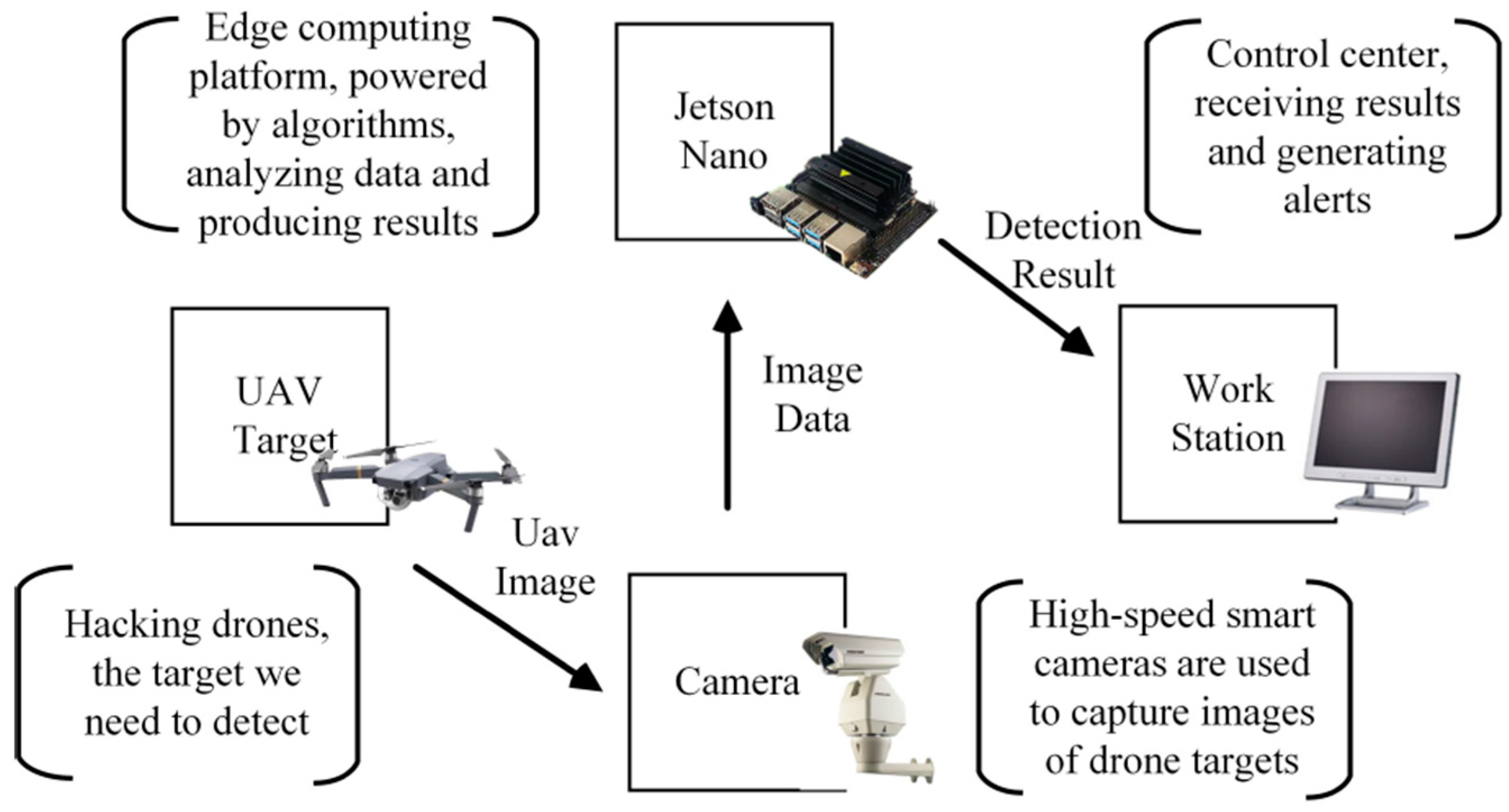
  207. Cheng, Q.; Wang, H.; Zhu, B.; Shi, Y.; Xie, B. A Real-Time UAV Target Detection Algorithm Based on Edge Computing. Drones 2023, 7, 95. [Google Scholar] [CrossRef]
  208. System on Module VS Single Board Computer. Available online: https://www.forlinx.net/industrial-news/som-vs-sbc-431.html (accessed on 15 March 2024).
  209. NXP i.MX 8 System on Module. Available online: https://www.variscite.de/variscite-products-imx8/?utm_source=google&utm_medium=cpc&utm_campaign=1746430699&utm_content=531817445452&utm_term=i.mx%208m&gad_source=1&gclid=EAIaIQobChMImMuf6rX2hAMV7RiiAx0Dig6aEAAYASAAEgKWp_D_BwE (accessed on 15 March 2024).
  210. High Performance CPU Recommended—Rockchip RK3399. Available online: https://www.forlinx.net/industrial-news/high-performance-cpu-recommended-rockchip-rk3399-331.html?gad_source=1&gclid=EAIaIQobChMIqOiSnbr2hAMVGz4GAB0ofwqZEAAYASAAEgKq6vD_BwE (accessed on 15 March 2024).
  211. Qualcomm Snapdragon Home Page. Available online: https://www.qualcomm.com/snapdragon/overview (accessed on 15 March 2024).
  212. STM32 32-bit Arm Cortex MCUs. Available online: https://www.st.com/en/microcontrollers-microprocessors/stm32-32-bit-arm-cortex-mcus.html (accessed on 15 March 2024).
  213. Martin, J.; Cantero, D.; González, M.; Cabrera, A.; Larrañaga, M.; Maltezos, E.; Lioupis, P.; Kosyvas, D.; Karagiannidis, L.; Ouzounoglou, E.; et al. Embedded Vision Intelligence for the Safety of Smart Cities. J. Imaging 2022, 8, 326. [Google Scholar] [CrossRef] [PubMed]
  214. Tang, G.; Hu, Y.; Xiao, H.; Zheng, L.; She, X.; Qin, N. Design of Real-time video transmission system based on 5G network. In Proceedings of the 2021 IEEE 16th Conference on Industrial Electronics and Applications (ICIEA), Chengdu, China, 1–4 August 2021. [Google Scholar] [CrossRef]
  215. Nguyen, P.H.; Arsalan, M.; Koo, J.H.; Naqvi, R.A.; Truong, N.Q.; Park, K.R. LightDenseYOLO: A Fast and Accurate Marker Tracker for Autonomous UAV Landing by Visible Light Camera Sensor on Drone. Sensors 2018, 18, 1703. [Google Scholar] [CrossRef] [PubMed]
  216. Buggiani, V.; Ortega, J.C.Ú.; Silva, G.; Rodríguez-Molina, J.; Vilca, D. An Inexpensive Unmanned Aerial Vehicle-Based Tool for Mobile Network Output Analysis and Visualization. Sensors 2023, 23, 1285. [Google Scholar] [CrossRef] [PubMed]
  217. Wu, T.; Guo, X.; Chen, Y.; Kumari, S.; Chen, C. Amassing the Security: An Enhanced Authentication Protocol for Drone Communications over 5G Networks. Drones 2022, 6, 10. [Google Scholar] [CrossRef]
  218. Cao, Y.; Qi, F.; Jing, Y.; Zhu, M.; Lei, T.; Li, Z.; Xia, J.; Wang, J.; Lu, G. Mission Chain Driven Unmanned Aerial Vehicle Swarms Cooperation for the Search and Rescue of Outdoor Injured Human Targets. Drones 2022, 6, 138. [Google Scholar] [CrossRef]
  219. Chen, J.I.-Z.; Lin, H.-Y. Performance Evaluation of a Quadcopter by an Optimized Proportional–Integral–Derivative Controller. Appl. Sci. 2023, 13, 8663. [Google Scholar] [CrossRef]
  220. Müezzinoğlu, T.; Karaköse, M. An Intelligent Human–Unmanned Aerial Vehicle Interaction Approach in Real Time Based on Machine Learning Using Wearable Gloves. Sensors 2021, 21, 1766. [Google Scholar] [CrossRef]
  221. Behjati, M.; Mohd Noh, A.B.; Alobaidy, H.A.H.; Zulkifley, M.A.; Nordin, R.; Abdullah, N.F. LoRa Communications as an Enabler for Internet of Drones towards Large-Scale Livestock Monitoring in Rural Farms. Sensors 2021, 21, 5044. [Google Scholar] [CrossRef]
  222. Saraereh, O.A.; Alsaraira, A.; Khan, I.; Uthansakul, P. Performance Evaluation of UAV-Enabled LoRa Networks for Disaster Management Applications. Sensors 2020, 20, 2396. [Google Scholar] [CrossRef] [PubMed]
  223. Mujumdar, O.; Celebi, H.; Guvenc, I.; Sichitiu, M.; Hwang, S.; Kang, K.-M. Use of LoRa for UAV Remote ID with Multi- User Interference and Different Spreading Factors. In Proceedings of the 2021 IEEE 93rd Vehicular Technology Conference (VTC2021-Spring), Helsinki, Finland, 25–28 April 2021. [Google Scholar] [CrossRef]
  224. Pan, M.; Chen, C.; Yin, X.; Huang, Z. UAV-Aided Emergency Environmental Monitoring in Infrastructure-Less Areas: LoRa Mesh Networking Approach. IEEE Internet Things J. 2021, 9, 2918–2932. [Google Scholar] [CrossRef]
  225. Delafontaine, V.; Schiano, F.; Cocco, G.; Rusu, A.; Floreano, D. Drone-aided Localization in LoRa IoT Networks. In Proceedings of the 2020 IEEE International Conference on Robotics and Automation (ICRA), Virtual, 31 May–31 August 2020; pp. 286–292. [Google Scholar] [CrossRef]
  226. Chen, L.-Y.; Huang, H.-S.; Wu, C.-J.; Tsai, Y.-T.; Chang, Y.-S. A LoRa-Based Air Quality Monitor on Unmanned Aerial Vehicle for Smart City. In Proceedings of the 2018 International Conference on System Science and Engineering (ICSSE), New Taipei City, Taiwan, 15 March 2018; pp. 1–5. [Google Scholar] [CrossRef]
  227. What Are LoRa and LoRaWAN? Available online: https://lora-developers.semtech.com/documentation/tech-papers-and-guides/lora-and-lorawan/#:~:text=The%20name%2C%20LoRa%2C%20is%20a,areas%20(line%20of%20sight) (accessed on 18 March 2024).
  228. LoRa Home Page. Available online: https://lora.readthedocs.io/en/latest/ (accessed on 18 March 2024).
  229. Semtech Home Page. Available online: https://www.semtech.fr/products/wireless-rf/lora-connect/sx1278 (accessed on 19 March 2024).
  230. Octopart Home Page. Available online: https://octopart.com/rn2483-i%2Frm101-microchip-71047793?gad_source=1&gclid=CjwKCAjw7-SvBhB6EiwAwYdCAUXvYbTF8jBuNfDDXZBN8BJdW5LwxVXLjAxHOuFNIg4A68ZtN7H8WhoCA-EQAvD_BwE (accessed on 19 March 2024).
  231. Octopart Home Page. Available online: https://octopart.com/rfm95w-868s2-hoperf-96011900?gad_source=1&gclid=CjwKCAjw7-SvBhB6EiwAwYdCAQmajTrwfiSlrfprQuTRZ-qruVAsB9ge_FQ3qGMuifw1dOdiyci55hoCNswQAvD_BwE (accessed on 19 March 2024).
  232. Zeng, T.; Mozaffari, M.; Semiari, O.; Saad, W.; Bennis, M.; Debbah, M. Wireless Communications and Control for Swarms of Cellular-Connected UAVs. In Proceedings of the 2018 52nd Asilomar Conference on Signals, Systems, and Computers, Pacific Grove, CA, USA, 28–31 October 2018. [Google Scholar] [CrossRef]
  233. Alhoraibi, L.; Alghazzawi, D.; Alhebshi, R.; Rabie, O.B.J. Physical Layer Authentication in Wireless Networks-Based Machine Learning Approaches. Sensors 2023, 23, 1814. [Google Scholar] [CrossRef] [PubMed]
  234. Guillen-Perez, A.; Sanchez-Iborra, R.; Cano, M.-D.; Sanchez-Aarnoutse, J.C.; Garcia-Haro, J. WiFi networks on drones. In Proceedings of the 2016 ITU Kaleidoscope: ICTs for a Sustainable World (ITU WT), Bangkok, Thailand, 14–16 November 2016. [Google Scholar] [CrossRef]
  235. Chen, Z.; Yin, D.; Chen, D.; Pan, M.; Lai, J. WiFi-based UAV Communication and Monitoring System in Regional Inspection. In Proceedings of the 2017 International Conference on Computer Technology, Electronics and Communication (ICCTEC), Dalian, China, 19–21 December 2017. [Google Scholar] [CrossRef]
  236. Anggraeni, P.; Khoirunnisa, H.; Rizal, M.N.; Alfadhila, M.F. Implementation of WiFi Communication on Multi UAV for Leader-Follower Trajectory based on ROS. In Proceedings of the 2023 International Conference on Artificial Intelligence in Information and Communication (ICAIIC), Bali, Indonesia, 20–23 February 2023. [Google Scholar] [CrossRef]
  237. Different Wi-Fi Protocols and Data Rates. Available online: https://www.intel.com/content/www/us/en/support/articles/000005725/wireless/legacy-intel-wireless-products.html (accessed on 20 March 2024).
  238. ESP8266 A Cost-Effective and Highly Integrated Wi-Fi MCU for IoT Applications. Available online: https://www.espressif.com/en/products/socs/esp8266 (accessed on 20 March 2024).
  239. ESP32 A Feature-Rich MCU with Integrated Wi-Fi and Bluetooth Connectivity for a Wide-Range of Applications. Available online: https://www.espressif.com/en/products/socs/esp32 (accessed on 20 March 2024).
  240. Adafruit CC3000 WiFi. Available online: https://learn.adafruit.com/adafruit-cc3000-wifi/overview (accessed on 20 March 2024).
  241. Nikodem, M.; Slabicki, M.; Bawiec, M. Efficient Communication Scheme for Bluetooth Low Energy in Large Scale Applications. Sensors 2020, 20, 6371. [Google Scholar] [CrossRef] [PubMed]
  242. Avilés-Viñas, J.; Carrasco-Alvarez, R.; Vázquez-Castillo, J.; Ortegón-Aguilar, J.; Estrada-López, J.J.; Jensen, D.D.; Peón-Escalante, R.; Castillo-Atoche, A. An Accurate UAV Ground Landing Station System Based on BLE-RSSI and Maximum Likelihood Target Position Estimation. Appl. Sci. 2022, 12, 6618. [Google Scholar] [CrossRef]
  243. Ariante, G.; Ponte, S.; Del Core, G. Bluetooth Low Energy based Technology for Small UAS Indoor Positioning. In Proceedings of the 2022 IEEE 9th International Workshop on Metrology for AeroSpace (MetroAeroSpace), Pisa, Italy, 27–29 June 2022. [Google Scholar] [CrossRef]
  244. Guruge, P.; Kocer, B.B.; Kayacan, E. A novel automatic UAV launcher design by using bluetooth low energy integrated electromagnetic releasing system. In Proceedings of the 2015 IEEE Region 10 Humanitarian Technology Conference (R10-HTC), Cebu City, Philippines, 9–12 December 2015. [Google Scholar] [CrossRef]
  245. nRF54H20 System-on-Chip. Available online: https://www.nordicsemi.com/Products/nRF54H20 (accessed on 20 March 2024).
  246. nRF54L15 System-on-Chip. Available online: https://www.nordicsemi.com/Products/nRF54L15 (accessed on 20 March 2024).
  247. SimpleLink™ 32-bit Arm Cortex-M3 Multiprotocol 2.4 GHz Wireless MCU with 128kB Flash. Available online: https://www.ti.com/product/CC2650?keyMatch=CC2650&tisearch=search-everything&usecase=GPN-ALT#tech-docs (accessed on 20 March 2024).
  248. Borkar, S.R. Long-term evolution for machines (LTE-M). In LPWAN Technologies for IoT and M2M Applications; Chaudhari, B.S., Zennaro, M., Eds.; Academic Press: Cambridge, MA, USA, 2020; pp. 145–166. [Google Scholar]
  249. Kukliński, S.; Szczypiorski, K.; Chemouil, P. UAV Support for Mission Critical Services. Energies 2022, 15, 5681. [Google Scholar] [CrossRef]
  250. Singh, R.; Jepsen, J.H.; Ballal, K.D.; Nwabuona, S.; Berger, M.; Dittmann, L. An Investigation of 5G, LTE, LTE-M and NB-IoT Coverage for Drone Communication Above 450 Feet. In Proceedings of the 2023 IEEE 24th International Symposium on a World of Wireless, Mobile and Multimedia Networks (WoWMoM), Boston, MA, USA, 12–15 June 2023. [Google Scholar] [CrossRef]
  251. MC Technologies Home Page. Available online: https://mc-technologies.com/en/produkt/quectel-module-bg95-m3-lga/ (accessed on 21 March 2024).
  252. Techship Home Page. Available online: https://techship.com/product/telit-me310g1-ww-cat-m1-nb-iot-ssku-lga/?variant=005 (accessed on 21 March 2024).
  253. Surojaya, A.; Zhang, N.; Bergado, J.R.; Nex, F. Towards Fully Autonomous UAV: Damaged Building-Opening Detection for Outdoor-Indoor Transition in Urban Search and Rescue. Electronics 2024, 13, 558. [Google Scholar] [CrossRef]
  254. Schraml, S.; Hubner, M.; Taupe, P.; Hofstätter, M.; Amon, P.; Rothbacher, D. Real-Time Gamma Radioactive Source Localization by Data Fusion of 3D-LiDAR Terrain Scan and Radiation Data from Semi-Autonomous UAV Flights. Sensors 2022, 22, 9198. [Google Scholar] [CrossRef] [PubMed]
  255. Zafar, M.A.; Rauf, A.; Ashraf, Z.; Akhtar, H. Design and development of effective manual control system for unmanned air vehicle. In Proceedings of the 2011 3rd International Conference on Computer Research and Development, Shanghai, China, 11–13 March 2011. [Google Scholar] [CrossRef]
  256. Elamin, A.; El-Rabbany, A. UAV-Based Multi-Sensor Data Fusion for Urban Land Cover Mapping Using a Deep Convolutional Neural Network. Remote Sens. 2022, 14, 4298. [Google Scholar] [CrossRef]
  257. Szafranski, G.; Czyba, R.; Janusz, W.; Blotnicki, W. Altitude estimation for the UAV’s applications based on sensors fusion algorithm. In Proceedings of the 2013 International Conference on Unmanned Aircraft Systems (ICUAS), Atlanta, GA, USA, 28–31 May 2013. [Google Scholar] [CrossRef]
  258. MS561101BA03-50. Available online: https://www.te.com/usa-en/product-MS561101BA03-50.html (accessed on 23 March 2024).
  259. Pressure Sensor BMP388. Available online: https://www.bosch-sensortec.com/products/environmental-sensors/pressure-sensors/bmp388/ (accessed on 23 March 2024).
  260. Weber, C.; von Eichel-Streiber, J.; Rodrigo-Comino, J.; Altenburg, J.; Udelhoven, T. Automotive Radar in a UAV to Assess Earth Surface Processes and Land Responses. Sensors 2020, 20, 4463. [Google Scholar] [CrossRef]
  261. Ya’acob, N.; Zolkapli, M.; Johari, J.; Yusof, A.L.; Sarnin, S.S.; Asmadinar, A.Z. UAV environment monitoring system. In Proceedings of the 2017 International Conference on Electrical, Electronics and System Engineering (ICEESE), Kanazawa, Japan, 9–10 November 2017. [Google Scholar] [CrossRef]
  262. Raeva, P.L.; Šedina, J.; Dlesk, A. Monitoring of crop fields using multispectral and thermal imagery from UAV. In Proceedings of the 37th EARSeL Symposium: Smart Future with Remote Sensing, Prague, Czech Republic, 27–30 June 2017. [Google Scholar] [CrossRef]
  263. Sengupta, P. Can Precision Agriculture Be the Future of Indian Farming?—A Case Study across the South-24 Parganas District of West Bengal, India. Biol. Life Sci. Forum 2024, 30, 3. [Google Scholar] [CrossRef]
  264. Singh, D.K.; Jerath, H.; Raja, P. Low Cost IoT Enabled Weather Station. In Proceedings of the 2020 International Conference on Computation, Automation and Knowledge Management (ICCAKM), Dubai, United Arab Emirates, 9–10 January 2020. [Google Scholar] [CrossRef]
  265. Shahadat, A.S.B.; Ayon, S.I.; Khatun, M.R. Efficient IoT based Weather Station. In Proceedings of the 2020 IEEE International Women in Engineering (WIE) Conference on Electrical and Computer Engineering (WIECON-ECE), Bhubaneswar, India, 26–27 December 2020. [Google Scholar] [CrossRef]
  266. SHT75. Available online: https://sensirion.com/products/catalog/SHT75/ (accessed on 23 March 2024).
  267. Mestre, G.; Ruano, A.; Duarte, H.; Silva, S.; Khosravani, H.; Pesteh, S.; Ferreira, P.M.; Horta, R. An Intelligent Weather Station. Sensors 2015, 15, 31005–31022. [Google Scholar] [CrossRef]
  268. Ladino, K.S.; Sama, M.P.; Stanton, V.L. Development and Calibration of Pressure-Temperature-Humidity (PTH) Probes for Distributed Atmospheric Monitoring Using Unmanned Aircraft Systems. Sensors 2022, 22, 3261. [Google Scholar] [CrossRef] [PubMed]
  269. Ricaud, P.; Medina, P.; Durand, P.; Attié, J.-L.; Bazile, E.; Grigioni, P.; Guasta, M.D.; Pauly, B. In Situ VTOL Drone-Borne Observations of Temperature and Relative Humidity over Dome C, Antarctica. Drones 2023, 7, 532. [Google Scholar] [CrossRef]
  270. Cai, W.; Du, S.; Yang, W. UAV image stitching by estimating orthograph with RGB cameras. J. Vis. Commun. Image Represent. 2023, 94, 103835. [Google Scholar] [CrossRef]
  271. Intel® RealSense™ Depth Camera D435. Available online: https://www.intelrealsense.com/depth-camera-d435/ (accessed on 24 March 2024).
  272. Kim, W.; Luong, T.; Ha, Y.; Doh, M.; Yax, J.F.M.; Moon, H. High-Fidelity Drone Simulation with Depth Camera Noise and Improved Air Drag Force Models. Appl. Sci. 2023, 13, 10631. [Google Scholar] [CrossRef]
  273. TaoZhang, R. UAV 3D mapping with RGB-D camera. In Proceedings of the 2017 Chinese Automation Congress (CAC), Jinan, China, 20–22 October 2017. [Google Scholar] [CrossRef]
  274. Yeom, S. Thermal Image Tracking for Search and Rescue Missions with a Drone. Drones 2024, 8, 53. [Google Scholar] [CrossRef]
  275. Feroz, S.; Abu Dabous, S. UAV-Based Remote Sensing Applications for Bridge Condition Assessment. Remote Sens. 2021, 13, 1809. [Google Scholar] [CrossRef]
  276. Yang, J.-C.; Lin, C.-J.; You, B.-Y.; Yan, Y.-L.; Cheng, T.-H. RTLIO: Real-Time LiDAR-Inertial Odometry and Mapping for UAVs. Sensors 2021, 21, 3955. [Google Scholar] [CrossRef]
  277. Melebari, A.; Nergis, P.; Eskandari, S.; Ramos Costa, P.; Moghaddam, M. Absolute Calibration of a UAV-Mounted Ultra-Wideband Software-Defined Radar Using an External Target in the Near-Field. Remote Sens. 2024, 16, 231. [Google Scholar] [CrossRef]
  278. Mekik, C.; Arslanoglu, M. Investigation on Accuracies of Real Time Kinematic GPS for GIS Applications. Remote Sens. 2009, 1, 22–35. [Google Scholar] [CrossRef]
  279. Heidarian Dehkordi, R.; Burgeon, V.; Fouche, J.; Placencia Gomez, E.; Cornelis, J.-T.; Nguyen, F.; Denis, A.; Meersmans, J. Using UAV Collected RGB and Multispectral Images to Evaluate Winter Wheat Performance across a Site Characterized by Century-Old Biochar Patches in Belgium. Remote Sens. 2020, 12, 2504. [Google Scholar] [CrossRef]
  280. NEO-M8 Series Versatile u-blox M8 GNSS Modules. Available online: https://www.u-blox.com/en/product/neo-m8-series (accessed on 24 March 2024).
  281. Yang, M.; Zhou, Z.; You, X. Research on Trajectory Tracking Control of Inspection UAV Based on Real-Time Sensor Data. Sensors 2022, 22, 3648. [Google Scholar] [CrossRef] [PubMed]
  282. Krzysztofik, I.; Koruba, Z. Study on the Sensitivity of a Gyroscope System Homing a Quadcopter onto a Moving Ground Target under the Action of External Disturbance. Energies 2021, 14, 1696. [Google Scholar] [CrossRef]
  283. Eling, C.; Klingbeil, L.; Kuhlmann, H. Real-Time Single-Frequency GPS/MEMS-IMU Attitude Determination of Lightweight UAVs. Sensors 2015, 15, 26212–26235. [Google Scholar] [CrossRef] [PubMed]
  284. Li, C.; Bulman, H.; Whitley, T.; Li, S. Ultra-Wideband Communication and Sensor Fusion Platform for the Purpose of Multi-Perspective Localization. Sensors 2022, 22, 6880. [Google Scholar] [CrossRef] [PubMed]
  285. Wu, P.; Su, S.; Zuo, Z.; Guo, X.; Sun, B.; Wen, X. Time Difference of Arrival (TDoA) Localization Combining Weighted Least Squares and Firefly Algorithm. Sensors 2019, 19, 2554. [Google Scholar] [CrossRef]
  286. Lian Sang, C.; Adams, M.; Hörmann, T.; Hesse, M.; Porrmann, M.; Rückert, U. Numerical and Experimental Evaluation of Error Estimation for Two-Way Ranging Methods. Sensors 2019, 19, 616. [Google Scholar] [CrossRef] [PubMed]
  287. DWM1000 3.5–6.5 GHz Ultra-Wideband (UWB) Transceiver Module. Available online: https://www.qorvo.com/products/p/DWM1000 (accessed on 25 March 2024).
  288. Steup, C.; Beckhaus, J.; Mostaghim, S. A Single-Copter UWB-Ranging-Based Localization System Extendable to a Swarm of Drones. Drones 2021, 5, 85. [Google Scholar] [CrossRef]
  289. Ultrasonic Distance Sensor-HC-SR04 (5V). Available online: https://www.sparkfun.com/products/15569 (accessed on 25 March 2024).
  290. Rahmaniar, W.; Wang, W.-J.; Caesarendra, W.; Glowacz, A.; Oprzędkiewicz, K.; Sułowicz, M.; Irfan, M. Distance Measurement of Unmanned Aerial Vehicles Using Vision-Based Systems in Unknown Environments. Electronics 2021, 10, 1647. [Google Scholar] [CrossRef]
  291. MB1222 I2CXL-MaxSonar-EZ2. Available online: https://maxbotix.com/products/mb1222 (accessed on 25 March 2024).
  292. Yang, L.; Feng, X.; Zhang, J.; Shu, X. Multi-Ray Modeling of Ultrasonic Sensors and Application for Micro-UAV Localization in Indoor Environments. Sensors 2019, 19, 1770. [Google Scholar] [CrossRef] [PubMed]
  293. van Berlo, B.; Elkelany, A.; Ozcelebi, T.; Meratnia, N. Millimeter Wave Sensing: A Review of Application Pipelines and Building Blocks. IEEE Sens. J. 2021, 21, 10332–10368. [Google Scholar] [CrossRef]
  294. Soumya, A.; Krishna Mohan, C.; Cenkeramaddi, L.R. Recent Advances in mmWave-Radar-Based Sensing, Its Applications, and Machine Learning Techniques: A Review. Sensors 2023, 23, 8901. [Google Scholar] [CrossRef] [PubMed]
  295. Başpınar, Ö.O.; Omuz, B.; Öncü, A. Detection of the Altitude and On-the-Ground Objects Using 77-GHz FMCW Radar Onboard Small Drones. Drones 2023, 7, 86. [Google Scholar] [CrossRef]
  296. AVIA. Available online: https://www.livoxtech.com/avia (accessed on 25 March 2024).
  297. Luo, H.; Wen, C.-Y. A Low-Cost Relative Positioning Method for UAV/UGV Coordinated Heterogeneous System Based on Visual-Lidar Fusion. Aerospace 2023, 10, 924. [Google Scholar] [CrossRef]
  298. Pourrahmani, H.; Bernier, C.M.I.; Van herle, J. The Application of Fuel-Cell and Battery Technologies in Unmanned Aerial Vehicles (UAVs): A Dynamic Study. Batteries 2022, 8, 73. [Google Scholar] [CrossRef]
  299. Bláha, L.; Severa, O.; Goubej, M.; Myslivec, T.; Reitinger, J. Automated Drone Battery Management System—Droneport: Technical Overview. Drones 2023, 7, 234. [Google Scholar] [CrossRef]
  300. Jarrah, K.; Alali, Y.; Lalko, A.; Rawashdeh, O. Flight Time Optimization and Modeling of a Hybrid Gasoline–Electric Multirotor Drone: An Experimental Study. Aerospace 2022, 9, 799. [Google Scholar] [CrossRef]
  301. Chu, Y.; Ho, C.; Lee, Y.; Li, B. Development of a Solar-Powered Unmanned Aerial Vehicle for Extended Flight Endurance. Drones 2021, 5, 44. [Google Scholar] [CrossRef]
  302. Osmani, K.; Haddad, A.; Alkhedher, M.; Lemenand, T.; Castanier, B.; Ramadan, M. A Novel MPPT-Based Lithium-Ion Battery Solar Charger for Operation under Fluctuating Irradiance Conditions. Sustainability 2023, 15, 9839. [Google Scholar] [CrossRef]
  303. Camas-Náfate, M.; Coronado-Mendoza, A.; Vargas-Salgado, C.; Águila-León, J.; Alfonso-Solar, D. Optimizing Lithium-Ion Battery Modeling: A Comparative Analysis of PSO and GWO Algorithms. Energies 2024, 17, 822. [Google Scholar] [CrossRef]
  304. Suti, A.; Di Rito, G.; Mattei, G. Development and Experimental Validation of Novel Thevenin-Based Hysteretic Models for Li-Po Battery Packs Employed in Fixed-Wing UAVs. Energies 2022, 15, 9249. [Google Scholar] [CrossRef]
  305. Tang, P.; Li, J.; Sun, H. A Review of Electric UAV Visual Detection and Navigation Technologies for Emergency Rescue Missions. Sustainability 2024, 16, 2105. [Google Scholar] [CrossRef]
  306. Guan, S.; Zhu, Z.; Wang, G. A Review on UAV-Based Remote Sensing Technologies for Construction and Civil Applications. Drones 2022, 6, 117. [Google Scholar] [CrossRef]
  307. Zhang, Z.; Zhu, L. A Review on Unmanned Aerial Vehicle Remote Sensing: Platforms, Sensors, Data Processing Methods, and Applications. Drones 2023, 7, 398. [Google Scholar] [CrossRef]
  308. Abro, G.E.M.; Zulkifli, S.A.B.M.; Masood, R.J.; Asirvadam, V.S.; Laouiti, A. Comprehensive Review of UAV Detection, Security, and Communication Advancements to Prevent Threats. Drones 2022, 6, 284. [Google Scholar] [CrossRef]
  309. Sharma, A.; Vanjani, P.; Paliwal, N.; Basnayaka, C.M.W.; Jayakody, D.N.K.; Wang, H.-C.; Muthuchidambaranathan, P. Communication and networking technologies for UAVs: A survey. J. Netw. Comput. Appl. 2020, 168, 102739. [Google Scholar] [CrossRef]
  310. Hu, X.; Assaad, R.H. The use of unmanned ground vehicles (mobile robots) and unmanned aerial vehicles (drones) in the civil infrastructure asset management sector: Applications, robotic platforms, sensors, and algorithms. Expert Syst. Appl. 2023, 232, 120897. [Google Scholar] [CrossRef]
  311. Ducard, G.J.J.; Allenspach, M. Review of designs and flight control techniques of hybrid and convertible VTOL UAVs. Aerosp. Sci. Technol. 2021, 118, 107035. [Google Scholar] [CrossRef]
  312. Saeed, A.S.; Younes, A.B.; Cai, C.; Cai, G. A survey of hybrid Unmanned Aerial Vehicles. Prog. Aerosp. Sci. 2018, 98, 91–105. [Google Scholar] [CrossRef]
  313. Digitalisierte, Rechtssichere und Emissionsarme Flugmobile Inspektion und Netzdatenerfassung mit Automatisierten Drohnen. Available online: https://www.hsu-hh.de/rt/forschung/dned (accessed on 28 March 2024).
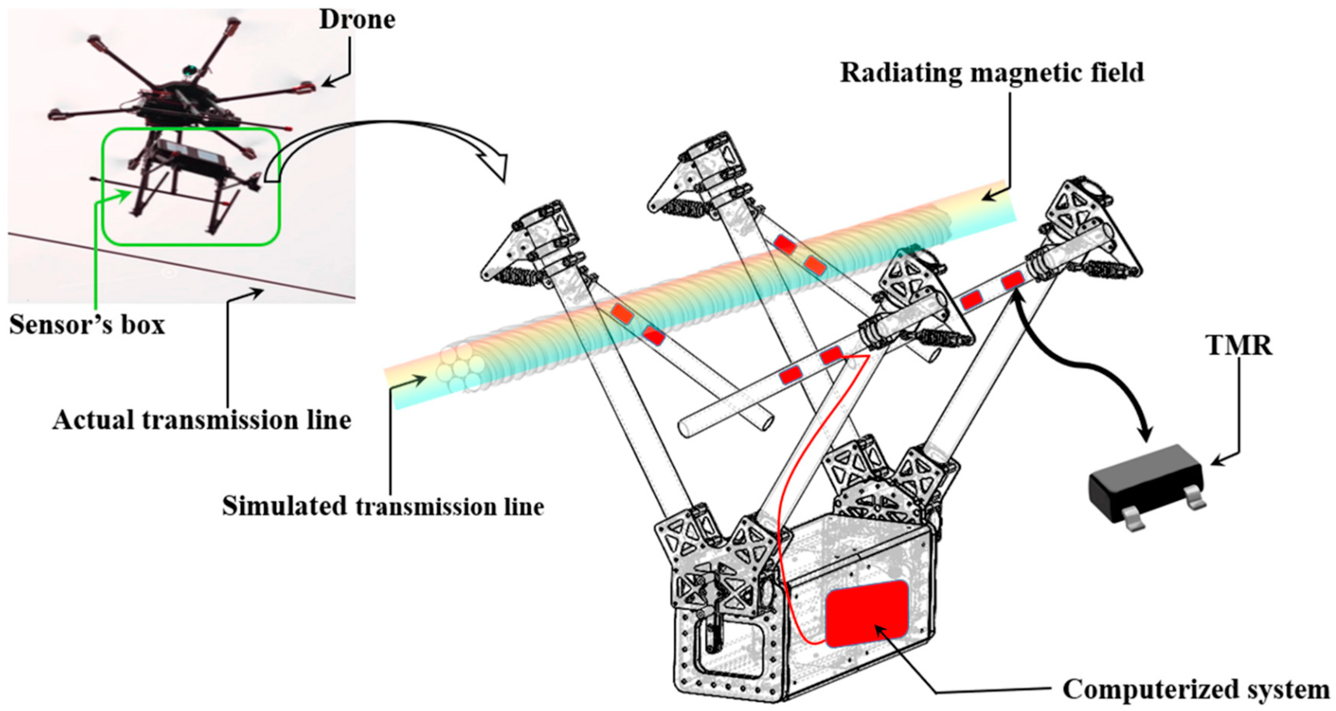
  314. Osmani, K.; Schulz, D. Modeling Magnetic Fields around Stranded Electrical Transmission Lines via Finite Element Analysis (FEA). Energies 2024, 17, 801. [Google Scholar] [CrossRef]
Figure 1. General overview of a UAV’s internal subsystems with the corresponding links.
Sensors 24 03064 g001
Figure 2. UAV localization through a set of georeferenced images [154].
Sensors 24 03064 g002
Figure 3. UAV target tracking: (a) YOLOv3, (b) YOLOv4, and (c) YOLOv5 [177].
Sensors 24 03064 g003
Figure 4. Overall block diagram representation of the control subsystem with field sensors [199].
Sensors 24 03064 g004
Figure 5. UAV (a) with Odroid XU4 as the on-board processor and (b) aerial docking [203].
Sensors 24 03064 g005
Figure 6. Proposed UAV object detection system based on NVIDIA Jetson Nano [207].
Sensors 24 03064 g006
Figure 7. Overview of the different reviewed UAV sensors.
Sensors 24 03064 g007
Figure 8. Sample thermography data obtained from a UAV-embedded thermal camera [275].
Sensors 24 03064 g008
Figure 9. UAV with added UWB modules and other sensors [283].
Sensors 24 03064 g009
Figure 10. Droneport schematic representation [299].
Sensors 24 03064 g010
Figure 11. Statistics of the current review.
Sensors 24 03064 g011
Figure 12. DNeD’s project overview [314].
Sensors 24 03064 g012
Table 1. Assessment of vision-based UAV navigation methods.
Vision-Based Navigation for UAVs
AdvantagesDisadvantagesChallengesField of Application
✓ Informative scene data✕ Complex environment structures reflect complexities in the navigation algorithmReal-time processing requirementsAgriculture
✓ Anti-jamming ability✕ Performance is impacted by adverse weather conditionsIntegration with image-based sensing modalities Surveillance
✓ Relatively high accuracy✕ Vulnerable to visual illusionsPower consumption Environmental monitoring
Table 2. Assessment of AI mathematical-based algorithms for UAV navigation.
Mathematical-Based AI Algorithms
AlgorithmRef.PerformanceEfficiencyContribution
PSO[112]HighModerateNon-feasible paths can be attained by means of an error factor
ACO[113]ModerateHighIntra-/inter-colony yield a better convergence toward an optimum
GA[114]HighHighChromosome decoding yields path navigation acknowledgment
DE[115]ModerateHighBetter convergence is achieved by means of selective mutations
GWO[116]HighHighFlexible algorithm hybridization with UAV navigation-based data
Table 3. Assessment of different sets of path planning and obstacle avoidance algorithms.
Algorithms SetWorking Mechanism
Sample-based
  • Divide the environment into a set of nodes.
  • Connect nodes via “depth-first” search procedure.
  • Begin the searching process for the optimal UAV route.
  • Easy to implement and better work online.
Mathematical-based
  • Describe constraints (i.e., dynamic/kinematic) mathematically.
  • Bind the cost function.
  • Require high computational resources.
  • Work better offline.
Multi-fusion
  • Integrate several algorithms.
  • Save time.
  • Appropriate to work online.
Bio-inspired
  • Heuristic-based.
  • Excellent handling of complex unstructured constraints.
  • Mutation is a key factor for path optimization.
  • Appropriate to work offline.
Table 4. Assessment of the YOLOv6, YOLOv7, and YOLOv8 algorithms.
YOLOvx-Algorithm Aspect
AlgorithmRef.Working MechanismAdditional ImprovementsPerformance
YOLOv6[181,182]
  • Anchor-free.
  • Decoupled head architecture (i.e., backbone: EfficientRep and neck: Rep-PAN).
  • Two loss functions for classification/regression.
Knowledge distillation (i.e., teacher–student training model)Achieves higher mean Average Precision (mAP) at different Frames Per Second (FPS) than its predecessors
YOLOv7[183,184]
  • Extended-Efficient Layer Aggregation Network (E-ELAN) is implemented in its backbone.
  • Compound model scaling.
  • Module level re-parametrization.
Presents trainable Bag-of-Freebies Improving accuracy simultaneously with maintained high detection speeds
YOLOv8[185]
  • Backbone (CSPDarknet53) is modified with five times sampled input features.
  • An enriched information flow is acquired by means of C2f (i.e., the number of bottlenecks).
  • Feature maps are efficiently pooled via the Spatial Pyramid Proofing Fast (SPPF) module.
Dynamic task-aligned allocator Positive and negative samples are specified by an anchor-free detection model
Table 5. Assessment of UAV SBCs.
SBCProcessorRAMCommunication *GPUCPU ClockProsCons
Raspberry Pi 464-bit quad-core ARM4 GB LPDDR4Ethernet, USB, HDMI, Bluetooth, Wi-Fi, I2C, SPI, UARTVideocore VI1.5 GHzUpgradable RAM to 8 GBOverheating
Odroid XU4Samsung Exynos 5422 octa-core2 GB LPDDR3USB, Ethernet, HDMI, I2C, SPI, UARTMali-T628 MP62 GHzHigh processor performanceIncompatible with 3.3 V and 5 V accessories
NVIDIA JetsonTX2Dual-core NVIDIA Denver 2 64-bit; quad-core ARM Cortex A578 GB LPDDR4Ethernet, USB, HDMI, UART, SPI, I2C, CAN256-core NVIDIA Pascal2 GHzGPU accelerationHigh power consumption
NanoQuad-core ARM Cortex A574 GB LPDDR4Ethernet, USB, HDMI, SPI, I2C, UART, CANNVIDIA Maxwell1.43 GHzGood parallel processingOverheating
* HDMI: High-Definition Multimedia Interface; I2C: Inter-Integrated Circuit; SPI: Serial Peripheral Interface; UART: Universal Asynchronous Receiver–Transmitter; CAN: Controller Area Network.
Table 6. Assessment of different UAV SoMs.
SoM Brand
CriteriaNXP I.MX8MRockchip RK3399Qualcomm SnapdragonSTM32 *
ProcessorARM Cortex A53, A72ARM Cortex A53, A72ARM Qualcomm KryoARM Cortex-M4
RAMUp to 4 GB LPDDR4Up to 4 GB LPDDR4Up to 8 GB LPDDR4Up to 640 kB SRAM
Main programming languagesC, C#, C++, Python, JavaC, C++, Python, JavaC, C#, C++, Kotlin, JavaC, C++, MicroPython
Programming structureSequential, concurrent, asynchronous, real-timeSequential, concurrent, asynchronous, real-timeSequential, concurrent, asynchronous, real-timeSequential, concurrent, asynchronous, real-time
Embedded wireless communicationWi-Fi, BluetoothWi-Fi, BluetoothWi-Fi, Bluetooth-
Power consumptionLowModerateModerateVery low
Supported temperature range−40 °C to +105 °C−40 °C to +80 °C−40 °C to +105 °C−40 °C to +125 °C
Outperforms inMultimedia, industrial IoTMultimedia, industrial IoTAI, graphic processing, 5GReal-time processing, embedded applications
* SRAM = Static Random-Access Memory.
Table 7. Assessment of different UAV’s communication modules.
Characteristics
Range *
Communication TechnologyModulePower
Consumption
Indoor
[km]
Outdoor
[km]
Supported Frequency Ranges [Hz]Max Data Rate (kbps)RAM (Bytes)Transmission Power [dBm]
LoRaSX1278Low5–1020137–1020 MHz300256–51220
RN2483Low5–1020433;868;915 MHz30032 k18
HOPERF RFM95W-86852Low5–1020860–1020 MHz300256–51220
Wi-FiESP8266Moderate0.05–0.10.32.4 GHz7296–16019
ESP32Moderate0.05–0.10.32.4;5 GHz150520–320 k19–20
CC3000Moderate0.030.12.4 GHz108 k14
BLEnRF54H20Low0.05–0.150.2–0.42.4 GHz2192–256−40 to +8
nRF54LI5Low0.05–0.150.2–0.42.4 GHz2192–256−40 to +8
CC2650Low0.05–0.150.2–0.42.4 GHz220–80 k−40 to +5
LTE-MQuectel BG95-M3LGALow--LTE-M/NB-IoT/GSM/GPRS58832–64 M23
Telit ME310G1-WWLow--LTE-M/NB-IoT58864 M23
* The range of the LTE-M modules is dependent on network coverage. Other ranges are taken as the most probable averages.
Table 8. Assessment of this paper in regards with other similar publications.
Ref.Criteria
ControlComputingCommunicationSensoryPower
NavigationTarget TrackingPayload IntegrationSBCsSoMLoRaWi-FiBLELTE-MEnvironmentalVisionPositionBatteryPV–BattGasoline–Batt
This work
[305]
[306]
[307]
[308]
[309]
[310]
Disclaimer/Publisher’s Note: The statements, opinions and data contained in all publications are solely those of the individual author(s) and contributor(s) and not of MDPI and/or the editor(s). MDPI and/or the editor(s) disclaim responsibility for any injury to people or property resulting from any ideas, methods, instructions or products referred to in the content.

