
A Novel Bayes Approach to Impervious Surface Extraction from High-Resolution Remote Sensing Images


Abstract
1. Introduction
- (1)
- This paper proposes a Gaussian prior-based Bayes discriminant analysis impervious surface extraction model that can extract highly accurate impervious surface information and clear boundaries;
- (2)
- The impervious surface model constructed based on Bayes discriminant analysis has the advantages of simple process, high computational efficiency and good comprehensive performance and can be used to extract impervious surface information from multi-scale high-resolution remote sensing images. It avoids the waste of computational resources, reduces the influence of subjective factors brought by sample selection in the extraction process and improves extraction accuracy;
- (3)
- The multivariate Gaussian distribution model is used to construct the prior model because of its wide adaptability and advantage in analyzing complex statistics. The GBDA model incorporating Gaussian prior enhances the generalization ability and improves the robustness, effectively improving the extraction accuracy of impervious surfaces of high-resolution remote sensing images and reducing the shadow misclassification phenomenon.
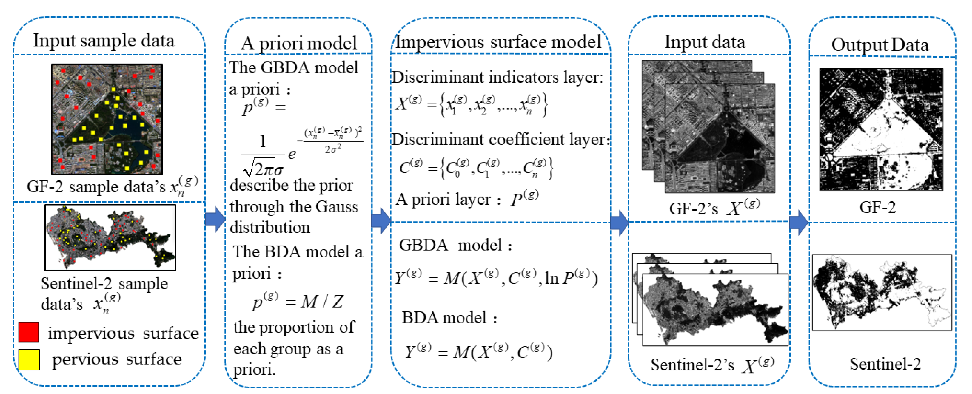
2. Methodology
2.1. A Novel Bayes Method for Impervious Surface Extraction from Remote Sensing Images
2.1.1. The Prior Model
2.1.2. Gaussian Prior-Based Bayes Discriminant Analysis Impervious Surface Extraction Model
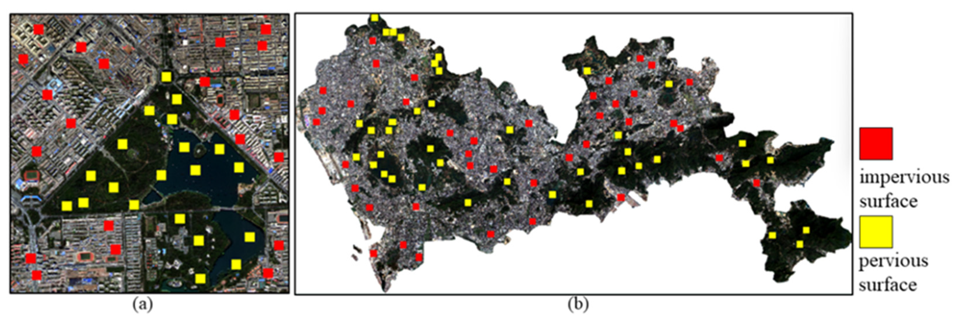
2.2. Extracting Features and Collecting Training Samples
2.3. Accuracy
3. Experiments and Results
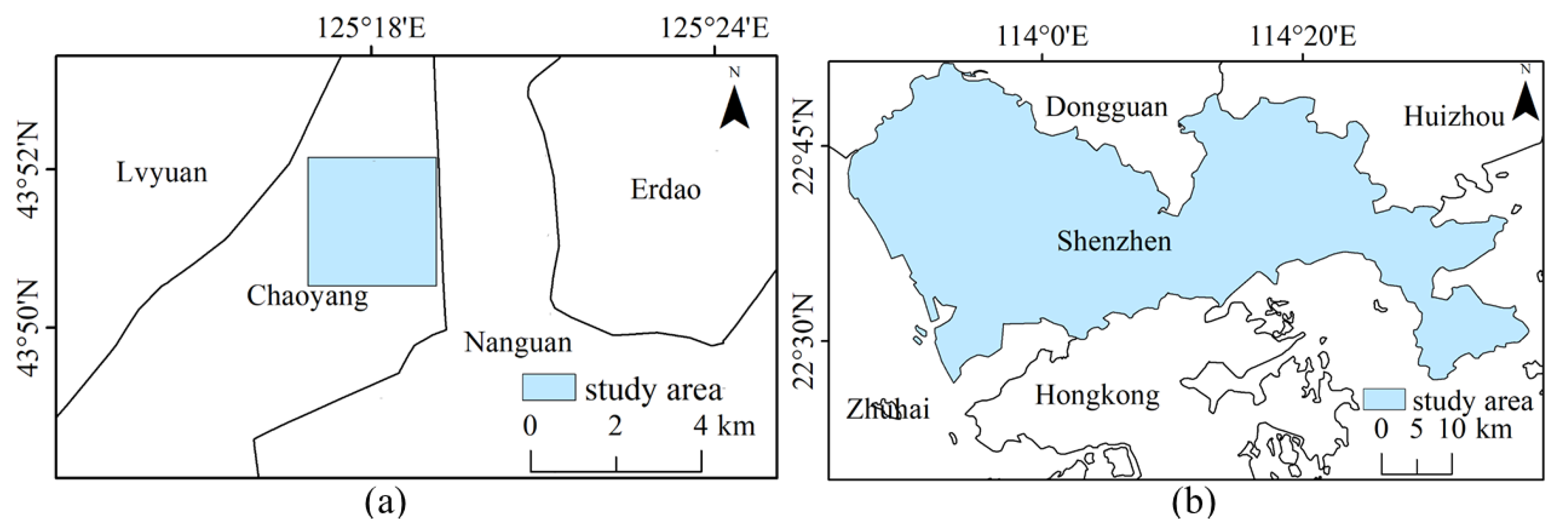
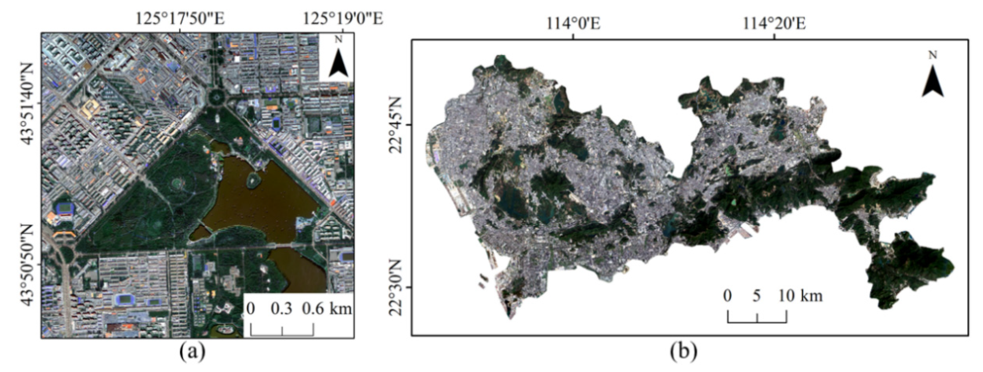
3.1. Experimental Areas and Data
3.1.1. Experimental Areas
3.1.2. Remote Sensing Data
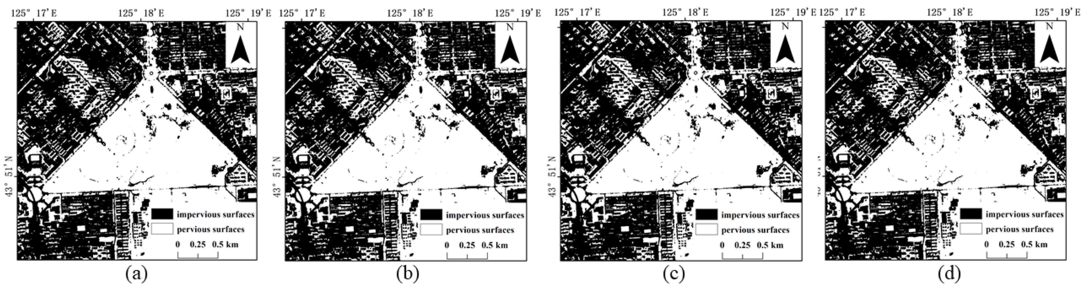
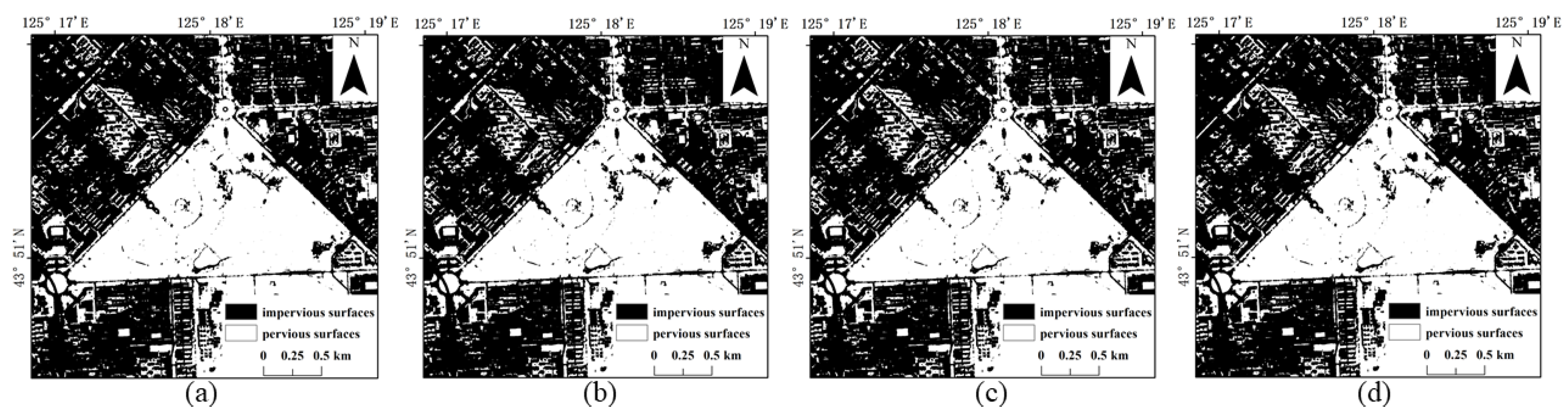
3.2. Impervious Surface Extraction Experiments Based on GF-2 Images
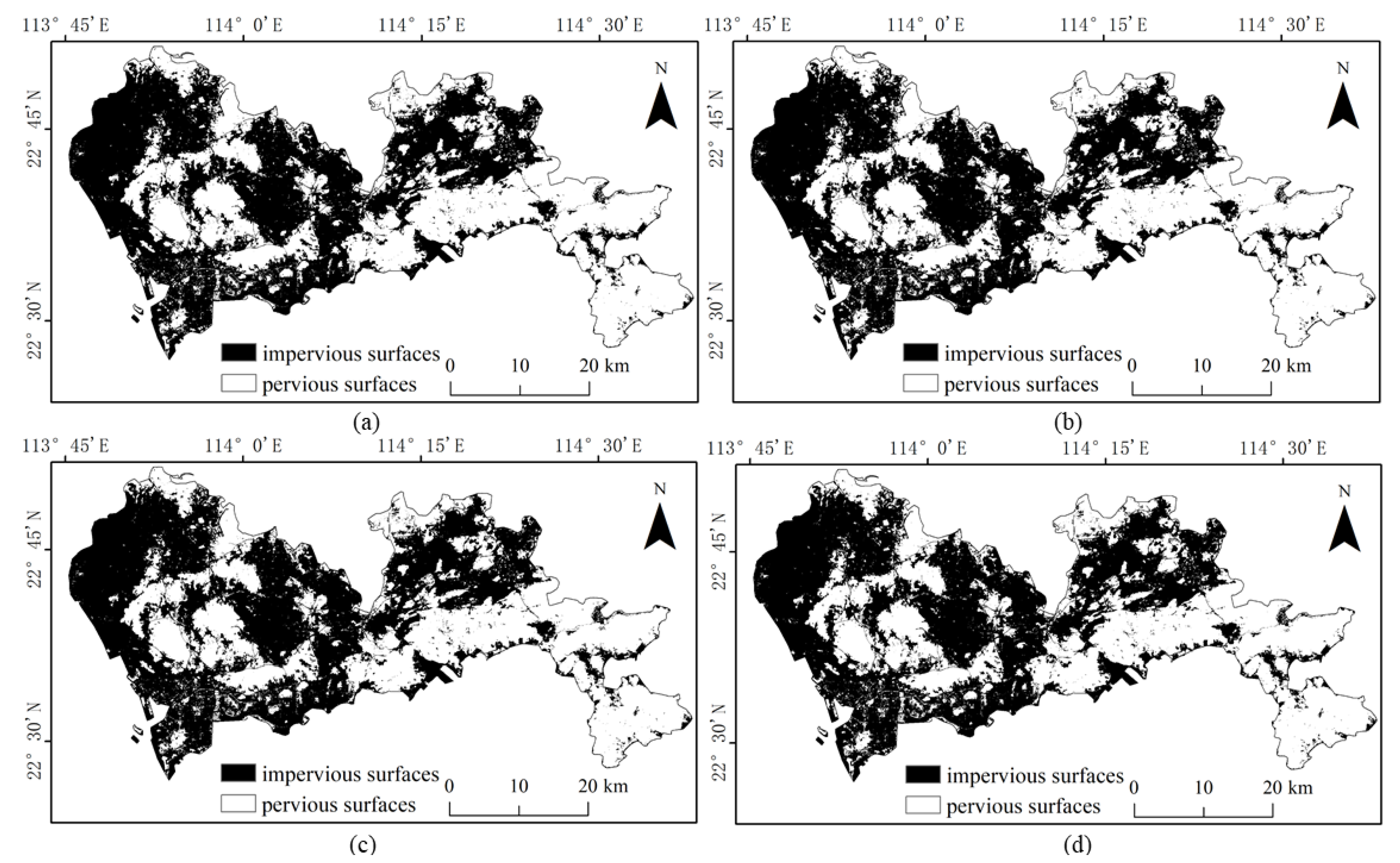
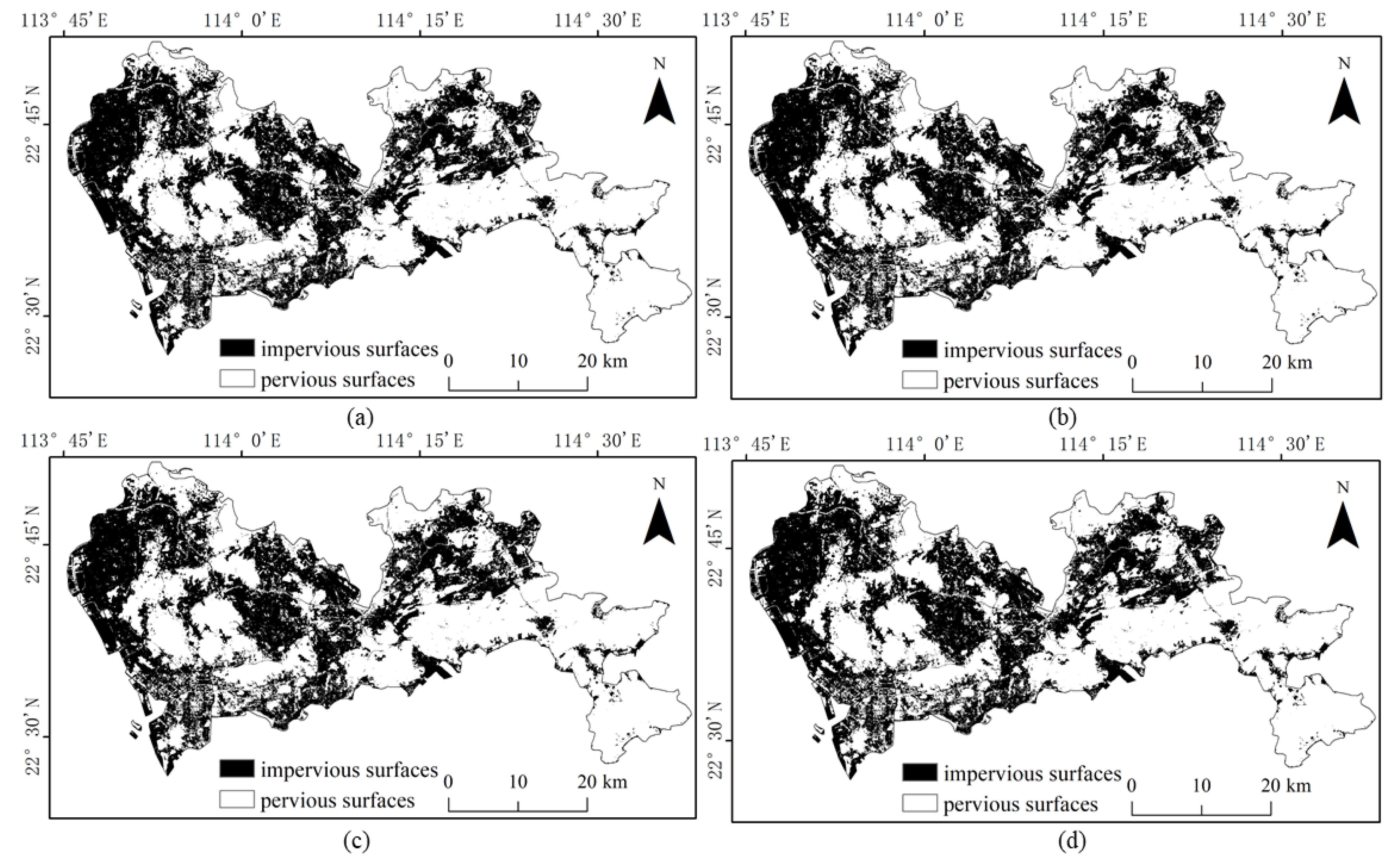
3.3. Impervious Surface Extraction Experiments Based on Sentinel-2 Images
3.4. The Analysis of Precision and Recall
4. Discussion
4.1. The Role of the Prior Model Optimization
4.2. Feasibility and Superiority of GBDA Model in Extracting Impervious Surface
4.3. Uncertainties and Limitations
5. Conclusions
- (1)
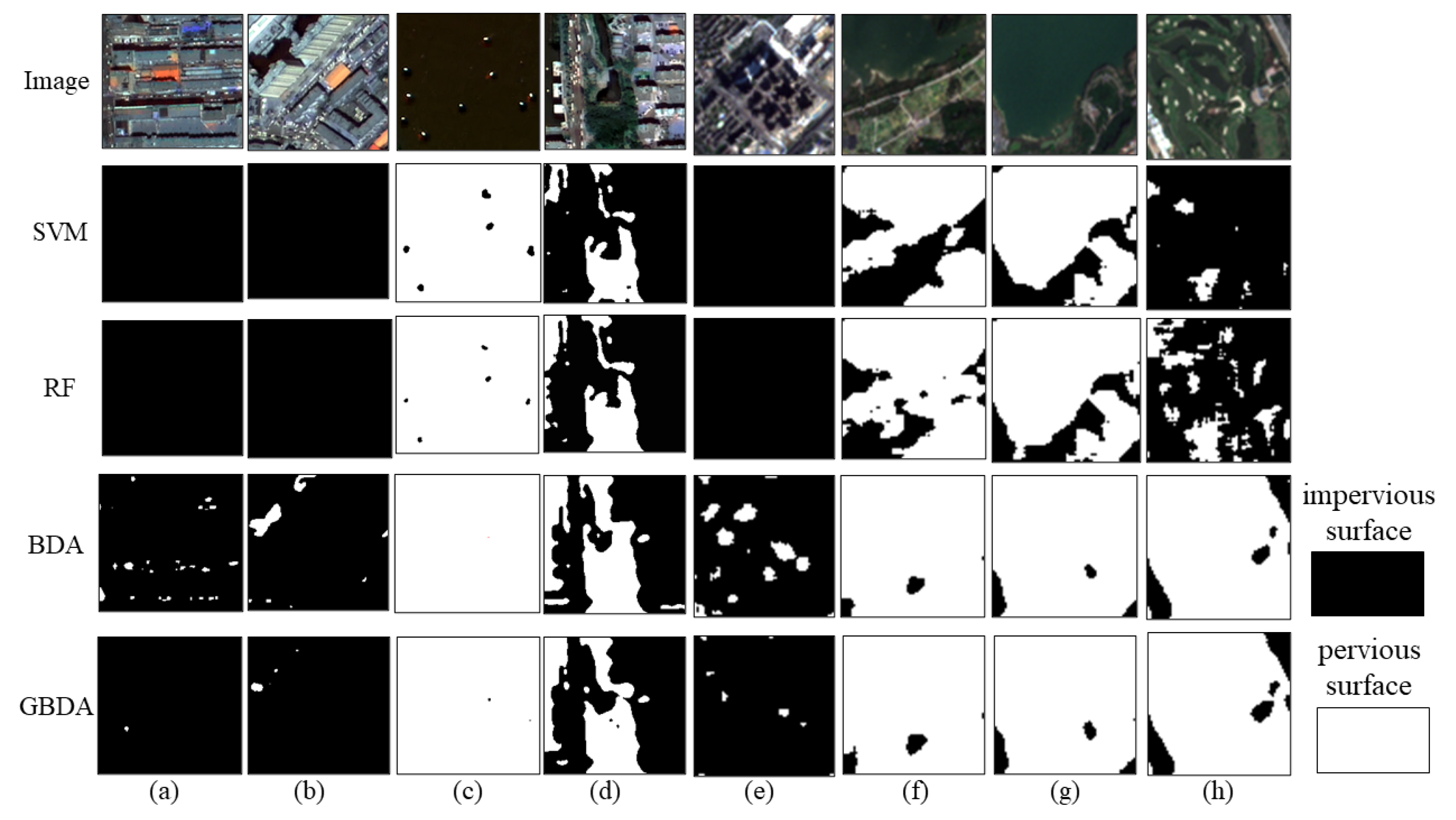
- Based on the analysis of the impervious surface extraction results of GF-2 and Sentinel-2 images, both BDA and GBDA methods have achieved better results. It has been proved that using the Bayes discriminant analysis idea to construct an impervious surface extraction model is a suitable method for multi-scale high-resolution remote sensing images with a simple process and high accuracy. Compared with SVM and RF methods, GBDA has better extraction performance;
- (2)
- The BDA uses the percentage of each group value as the prior and the model has fitting problems. In this paper, the prior of BDA is improved to Gaussian prior distribution, which can effectively improve the shadow misclassification phenomenon generated by high-resolution images and improve the extraction accuracy, proving that the improvement of the prior enhances the robustness and generalization ability of the model.
Author Contributions
Funding
Institutional Review Board Statement
Informed Consent Statement
Data Availability Statement
Conflicts of Interest
References
- Xu, H.; Wang, M. Remote sensing-based retrieval of ground impervious surfaces. J. Remote Sens. 2016, 20, 1270–1289. [Google Scholar]
- Yu, Y.; Li, J.; Zhu, C.; Plaza, A. Urban Impervious Surface Estimation from Remote Sensing and Social Data. Photogramm. Eng. Remote Sens. 2018, 84, 771–780. [Google Scholar] [CrossRef]
- Tang, Y.; Shao, Z.; Huang, X.; Cai, B. Mapping Impervious Surface Areas Using Time-Series Nighttime Light and MODIS Imagery. Remote Sens. 2021, 13, 1900. [Google Scholar] [CrossRef]
- Hoang, N.D. Automatic Impervious Surface Area Detection Using Image Texture Analysis and Neural Computing Models with Advanced Optimizers. Comput. Intell. Neurosci. 2021, 2021, 8820116. [Google Scholar] [CrossRef] [PubMed]
- Morabito, M.; Crisci, A.; Guerri, G.; Messeri, A.; Congedo, L.; Munafo, M. Surface urban heat islands in Italian metropolitan cities: Tree cover and impervious surface influences. Sci. Total Environ. 2021, 751, 142334. [Google Scholar] [CrossRef] [PubMed]
- Cai, C.; Li, P.; Jin, H. Extraction of Urban Impervious Surface Using Two-Season WorldView-2 Images: A Comparison. Photogramm. Eng. Remote Sens. 2016, 82, 335–349. [Google Scholar] [CrossRef]
- Ma, Y.; Zhang, S.; Yang, K.; Li, M. Influence of spatiotemporal pattern changes of impervious surface of urban megaregion on thermal environment: A case study of the Guangdong–Hong Kong–Macao Greater Bay Area of China. Ecol. Indic. 2021, 121, 107106. [Google Scholar] [CrossRef]
- Kuang, W. Mapping global impervious surface area and green space within urban environments. Sci. China Earth Sci. 2019, 62, 1591–1606. [Google Scholar] [CrossRef]
- Wang, M.; Song, Y.; Wang, F.; Meng, Z. Boundary Extraction of Urban Built-Up Area Based on Luminance Value Correction of NTL Image. IEEE J. Sel. Top. Appl. Earth Observ. Remote Sens. 2021, 14, 7466–7477. [Google Scholar] [CrossRef]
- Ouyang, Z.; Lin, M.; Chen, J.; Fan, P.; Qian, S.S.; Park, H. Improving estimates of built-up area from night time light across globally distributed cities through hierarchical modeling. Sci. Total Environ. 2019, 647, 1266–1280. [Google Scholar] [CrossRef]
- Liu, C.; Zhang, Q.; Luo, H.; Qi, S.; Tao, S.; Xu, H.; Yao, Y. An efficient approach to capture continuous impervious surface dynamics using spatial-temporal rules and dense Landsat time series stacks. Remote Sens. Environ. 2019, 229, 114–132. [Google Scholar] [CrossRef]
- Tang, P.; Du, P.; Lin, C.; Guo, S.; Qie, L. A Novel Sample Selection Method for Impervious Surface Area Mapping Using JL1-3B Nighttime Light and Sentinel-2 Imagery. IEEE J. Sel. Top. Appl. Earth Observ. Remote Sens. 2020, 13, 3931–3941. [Google Scholar] [CrossRef]
- Feng, S.; Fan, F. A Hierarchical Extraction Method of Impervious Surface Based on NDVI Thresholding Integrated with Multispectral and High-Resolution Remote Sensing Imageries. IEEE J. Sel. Top. Appl. Earth Observ. Remote Sens. 2019, 12, 1461–1470. [Google Scholar] [CrossRef]
- Shao, Z.; Fu, H.; Li, D.; Altan, O.; Cheng, T. Remote sensing monitoring of multi-scale watersheds impermeability for urban hydrological evaluation. Remote Sens. Environ. 2019, 232, 111338. [Google Scholar] [CrossRef]
- Wang, Y.; Li, M. Urban Impervious Surface Automatic Threshold Detection Model Derived from Multitemporal Landsat Images. IEEE Trans. Geosci. Remote Sens. 2021, 60, 4503321. [Google Scholar] [CrossRef]
- Huang, M.; Chen, N.; Du, W.; Wen, M.; Zhu, D.; Gong, J. An on-demand scheme driven by the knowledge of geospatial distribution for large-scale high-resolution impervious surface mapping. GISci. Remote Sens. 2021, 58, 562–586. [Google Scholar] [CrossRef]
- Hsieh, P.; Lee, L.; Chen, N. Effect of spatial resolution on classification errors of pure and mixed pixels in remote sensing. IEEE Trans. Geosci. Remote Sens. 2002, 39, 2657–2663. [Google Scholar] [CrossRef]
- Liu, Z.; Wang, M.; Wang, F.; Ji, X.; Meng, Z. A Dual-Channel Fully Convolutional Network for Land Cover Classification Using Multifeature Information. IEEE J. Sel. Top. Appl. Earth Observ. Remote Sens. 2022, 15, 2099–2109. [Google Scholar] [CrossRef]
- Weng, Q. Remote sensing of impervious surfaces in the urban areas: Requirements, methods, and trends. Remote Sens. Environ. 2012, 117, 34–49. [Google Scholar] [CrossRef]
- Xu, X.; Liu, C.; Liu, C.; Hui, F.; Cheng, X.; Huang, H. Fine-resolution mapping of the circumpolar Arctic Man-made impervious areas (CAMI) using sentinels, OpenStreetMap and ArcticDEM. Big Earth Data 2022, 1–22. [Google Scholar] [CrossRef]
- Shrestha, B.; Ahmad, S.; Stephen, H. Fusion of Sentinel-1 and Sentinel-2 data in mapping the impervious surfaces at city scale. Environ. Monit. Assess. 2021, 193, 556. [Google Scholar] [CrossRef] [PubMed]
- Misra, M.; Kumar, D.; Shekhar, S. Assessing Machine Learning Based Supervised Classifiers for Built-Up Impervious Surface Area Extraction from Sentinel-2 Images. Urban For. Urban Green. 2020, 53, 126714. [Google Scholar] [CrossRef]
- Xu, R.; Liu, J.; Xu, J. Extraction of High-Precision Urban Impervious Surfaces from Sentinel-2 Multispectral Imagery via Modified Linear Spectral Mixture Analysis. Sensors 2018, 18, 2873. [Google Scholar] [CrossRef] [PubMed]
- Lu, D.; Weng, Q. Extraction of urban impervious surfaces from an IKONOS image. Int. J. Remote Sens. 2009, 30, 1297–1311. [Google Scholar] [CrossRef]
- Wang, Y.; Li, M. Urban Impervious Surface Detection from Remote Sensing Images: A review of the methods and challenges. IEEE Geosci. Remote Sens. Mag. 2019, 7, 64–93. [Google Scholar] [CrossRef]
- Degerickx, J.; Roberts, D.A.; Somers, B. Enhancing the performance of Multiple Endmember Spectral Mixture Analysis (MESMA) for urban land cover mapping using airborne lidar data and band selection. Remote Sens. Environ. 2019, 221, 260–273. [Google Scholar] [CrossRef]
- Zhang, J.; He, C.; Zhou, Y.; Zhu, S.; Shuai, G. Prior-knowledge-based spectral mixture analysis for impervious surface mapping. Int. J. Appl. Earth Obs. Geoinf. 2014, 28, 201–210. [Google Scholar] [CrossRef]
- Deliry, S.I.; Avdan, Z.Y.; Avdan, U. Extracting urban impervious surfaces from Sentinel-2 and Landsat-8 satellite data for urban planning and environmental management. Environ. Sci. Pollut. Res. 2021, 28, 6572–6586. [Google Scholar] [CrossRef]
- Shalaby, A.; Tateishi, R. Remote sensing and GIS for mapping and monitoring land cover and land-use changes in the Northwestern coastal zone of Egypt. Appl. Geogr. 2007, 27, 28–41. [Google Scholar] [CrossRef]
- Kavzoglu, T.; Mather, P.M. The use of backpropagating artificial neural networks in land cover classification. Int. J. Remote Sens. 2003, 24, 4907–4938. [Google Scholar] [CrossRef]
- Ridd, M.K. Exploring a V-I-S (vegetation-impervious surface-soil) model for urban ecosystem analysis through remote sensing: Comparative anatomy for cities†. Int. J. Remote Sens. 2007, 16, 2165–2185. [Google Scholar] [CrossRef]
- Sarapirome, S.; Kulrat, C. Comparison on Urban Classifications using Landsat-TM and Linear Spectral Mixture Analysis Extracted Images: Nakhon Ratchasima Municipal Area, Thailand. Suranaree J. Sci. Technol. 2010, 17, 401–411. [Google Scholar]
- Powell, R.L.; Roberts, D.A.; Dennison, P.E.; Hess, L.L. Sub-pixel mapping of urban land cover using multiple endmember spectral mixture analysis: Manaus, Brazil. Remote Sens. Environ. 2007, 106, 253–267. [Google Scholar] [CrossRef]
- Franke, J.; Roberts, D.A.; Halligan, K.; Menz, G. Hierarchical Multiple Endmember Spectral Mixture Analysis (MESMA) of hyperspectral imagery for urban environments. Remote Sens. Environ. 2009, 113, 1712–1723. [Google Scholar] [CrossRef]
- Liu, C.; Huang, X.; Zhu, Z.; Chen, H.; Tang, X.; Gong, J. Automatic extraction of built-up area from ZY3 multi-view satellite imagery: Analysis of 45 global cities. Remote Sens. Environ. 2019, 226, 51–73. [Google Scholar] [CrossRef]
- Deng, C.; Wu, C. BCI: A biophysical composition index for remote sensing of urban environments. Remote Sens. Environ. 2012, 127, 247–259. [Google Scholar] [CrossRef]
- Wang, Z.; Gang, C.; Li, X.; Chen, Y.; Li, J. Application of a normalized difference impervious index (NDII) to extract urban impervious surface features based on Landsat TM images. Int. J. Remote Sens. 2015, 36, 1055–1069. [Google Scholar] [CrossRef]
- Xu, H. Analysis of Impervious Surface and its Impact on Urban Heat Environment using the Normalized Difference Impervious Surface Index (NDISI). Photogramm. Eng. Remote Sens. 2010, 76, 557–565. [Google Scholar] [CrossRef]
- Liu, C.; Shao, Z.; Chen, M.; Luo, H. MNDISI: A multi-source composition index for impervious surface area estimation at the individual city scale. Remote Sens. Lett. 2013, 4, 803–812. [Google Scholar] [CrossRef]
- Xie, Y.; Weng, Q.; Fu, P. Temporal variations of artificial nighttime lights and their implications for urbanization in the conterminous United States, 2013–2017. Remote Sens. Environ. 2019, 225, 160–174. [Google Scholar] [CrossRef]
- Zhong, Q.; Ma, J.; Zhao, B.; Wang, X.; Zong, J.; Xiao, X. Assessing spatial-temporal dynamics of urban expansion, vegetation greenness and photosynthesis in megacity Shanghai, China during 2000–2016. Remote Sens. Environ. 2019, 233, 111374. [Google Scholar] [CrossRef]
- Kaur, R.; Pandey, P. A review on spectral indices for built-up area extraction using remote sensing technology. Arab. J. Geosci. 2022, 15, 391. [Google Scholar] [CrossRef]
- Gong, P.; Wang, J.; Yu, L.; Zhao, Y.; Zhao, Y.; Liang, L. Finer resolution observation and monitoring of global land cover: First mapping results with Landsat TM and ETM+ data. Int. J. Remote Sens. 2013, 34, 2607–2654. [Google Scholar] [CrossRef]
- Gong, P.; Liu, H.; Zhang, M.; Li, C.; Wang, J.; Huang, H. Stable classification with limited sample: Transferring a 30-m resolution sample set collected in 2015 to mapping 10-m resolution global land cover in 2017. Sci. Bull. 2019, 64, 370–373. [Google Scholar] [CrossRef]
- Liang, Z.; Wang, C.; Zhang, Z.; Khan, K.U.J. A comparison of statistical and machine learning methods for debris flow susceptibility mapping. Stoch. Environ. Res. Risk Assess. 2020, 34, 1887–1907. [Google Scholar] [CrossRef]
- Wen, C.; Tian, Q. Assessment of Urban Road Traffic Safety Based on Bayes Discriminant Analysis Method. Adv. Mater. Res. 2013, 639–640, 544–547. [Google Scholar] [CrossRef]
- He, X.; Wang, J.; You, X.; Niu, F.; Fan, L.; Lv, Y. Classification of heroin, methamphetamine, ketamine and their additives by attenuated total reflection-Fourier transform infrared spectroscopy and chemometrics. Spectroc. Acta Pt. A Molec. Biomolec. Spectr. 2020, 241, 118665. [Google Scholar] [CrossRef]
- Xu, W.; Jing, S.; Yu, W.; Wang, Z.; Zhang, G.; Huang, J. A comparison between Bayes discriminant analysis and logistic regression for prediction of debris flow in southwest Sichuan, China. Geomorphology 2013, 201, 45–51. [Google Scholar] [CrossRef]
- Yang, T.; Wang, J. Prediction Model of Flush Flood and Debris Flow in Taihang Mountains Areas Based on Bayes Discriminatory Analysis. Appl. Mech. Mater. 2013, 316–317, 400–403. [Google Scholar] [CrossRef]
- Gong, F.; Li, X.; Zhang, W. Over-excavation Forecast of Underground Opening by Using Bayes Discriminant Analysis Method. J. Cent. South Univ. Technol. 2008, 15, 498–502. [Google Scholar] [CrossRef]
- Shi, Y.; He, D.; Qin, F. Study on bayes discriminant analysis of EEG data. Open Biomed. Eng. J. 2014, 8, 142–146. [Google Scholar] [CrossRef] [PubMed]
- Wu, D.; Fu, X.; Wen, Y.; Liu, B.; Deng, Z.; Dai, L. High-resolution melting combines with Bayes discriminant analysis: A novel hepatitis C virus genotyping method. Clin. Exper. Med. 2017, 17, 325–332. [Google Scholar] [CrossRef] [PubMed]
- Jia, D.; Yi, S. Classification of Hoi-An and Sin-Chew Agarwood by Components Analysis of VOCs Released in Heat-Treated Agarwood using TD-GCMS and Chemometric Methods. BioResources 2018, 13, 2916–2931. [Google Scholar] [CrossRef]
- Hou, W.; Wang, J.; He, X. Spectral classification and identification of methamphetamine and its common additives based on multivariate modeling. Laser Optoelectron. Prog. 2021, 58, 0330003. [Google Scholar] [CrossRef]
- Qian, G.; Song, X.; Sun, J.; Zhang, S.; Zhou, X.; Zhang, G. Prediction of peak occurrence of Dendrolimus punctatus larvae based on Bayes discriminant method. Entomol. Res. 2020, 50, 393–401. [Google Scholar] [CrossRef]
- Xu, J.; Xu, W.; Qin, X. Design of Online Purchasing Mechanism Based on Gaussian Distribution and Its Competitive Analysis. Oper. Res. Manag. Sci. 2021, 30, 98–103. [Google Scholar]
- Zhang, H.; Wang, M.; Wang, F.; Yang, G.; Zhang, Y.; Jia, J. A Novel Squeeze-and-Excitation W-Net for 2D and 3D Building Change Detection with Multi-Source and Multi-Feature Remote Sensing Data. Remote Sens. 2021, 13, 440. [Google Scholar] [CrossRef]
- Liu, Z.; Wang, M.; Wang, F.; Ji, X. A Residual Attention and Local Context-Aware Network for Road Extraction from High-Resolution Remote Sensing Imagery. Remote Sens. 2021, 13, 4958. [Google Scholar] [CrossRef]
- Wang, M.; Zhang, X.; Niu, X.; Wang, F.; Zhang, X. Scene Classification of High-Resolution Remotely Sensed Image Based on ResNet. J. Geovis. Spat. Anal. 2019, 3, 16. [Google Scholar] [CrossRef]


| SVM | RF | BDA | GBDA | |||||||||
|---|---|---|---|---|---|---|---|---|---|---|---|---|
| OA (%) | Kappa | F1 | OA (%) | Kappa | F1 | OA (%) | Kappa | F1 | OA (%) | Kappa | F1 | |
| 40,000 | 90.87 | 0.8175 | 0.9161 | 94.81 | 0.8961 | 0.9505 | 94.64 | 0.8927 | 0.9437 | 97.84 | 0.9568 | 0.9785 |
| 60,000 | 91.06 | 0.8211 | 0.9177 | 94.75 | 0.8950 | 0.9500 | 94.51 | 0.8901 | 0.9422 | 97.74 | 0.9548 | 0.9774 |
| 80,000 | 91.26 | 0.8253 | 0.9194 | 94.91 | 0.8983 | 0.9514 | 94.61 | 0.8921 | 0.9433 | 97.78 | 0.9556 | 0.9777 |
| 100,000 | 91.07 | 0.8214 | 0.9178 | 94.84 | 0.8970 | 0.9563 | 94.62 | 0.8924 | 0.9434 | 97.82 | 0.9564 | 0.9781 |
| SVM | RF | BDA | GBDA | |||||||||
|---|---|---|---|---|---|---|---|---|---|---|---|---|
| OA (%) | Kappa | F1 | OA (%) | Kappa | F1 | OA (%) | Kappa | F1 | OA (%) | Kappa | F1 | |
| 80,000 | 86.89 | 0.7378 | 0.8833 | 91.70 | 0.8340 | 0.9223 | 92.19 | 0.8438 | 0.9207 | 93.51 | 0.8703 | 0.9368 |
| 120,000 | 87.94 | 0.7588 | 0.8914 | 91.60 | 0.8320 | 0.9215 | 92.08 | 0.8415 | 0.9195 | 93.46 | 0.8693 | 0.9363 |
| 160,000 | 85.50 | 0.7100 | 0.8725 | 91.79 | 0.8359 | 0.9231 | 92.07 | 0.8415 | 0.9195 | 93.46 | 0.8692 | 0.9363 |
| 200,000 | 86.92 | 0.7383 | 0.8834 | 91.60 | 0.8320 | 0.9214 | 92.10 | 0.8420 | 0.9198 | 93.44 | 0.8688 | 0.9359 |
| SVM | RF | BDA | GBDA | |||||
|---|---|---|---|---|---|---|---|---|
| Precision (%) | Recall (%) | Precision (%) | Recall (%) | Precision (%) | Recall (%) | Precision (%) | Recall (%) | |
| 40,000 | 84.76 | 99.67 | 90.89 | 99.60 | 99.30 | 89.91 | 97.82 | 97.87 |
| 60,000 | 85.00 | 99.70 | 90.79 | 99.61 | 99.38 | 89.57 | 97.42 | 98.07 |
| 80,000 | 85.31 | 99.69 | 91.06 | 99.61 | 99.39 | 89.76 | 97.96 | 97.59 |
| 100,000 | 85.04 | 99.68 | 90.96 | 99.60 | 99.35 | 89.82 | 97.94 | 97.69 |
| SVM | RF | BDA | GBDA | |||||
|---|---|---|---|---|---|---|---|---|
| Precision (%) | Recall (%) | Precision (%) | Recall (%) | Precision (%) | Recall (%) | Precision (%) | Recall (%) | |
| 80,000 | 79.61 | 99.19 | 86.64 | 98.60 | 93.46 | 90.72 | 91.28 | 96.22 |
| 120,000 | 81.06 | 99.01 | 86.53 | 98.54 | 93.42 | 90.53 | 91.28 | 96.11 |
| 160,000 | 77.84 | 99.26 | 86.81 | 98.56 | 93.43 | 90.52 | 91.20 | 96.20 |
| 200,000 | 79.65 | 99.17 | 86.52 | 98.55 | 93.42 | 90.58 | 91.48 | 95.80 |
Publisher’s Note: MDPI stays neutral with regard to jurisdictional claims in published maps and institutional affiliations. |
© 2022 by the authors. Licensee MDPI, Basel, Switzerland. This article is an open access article distributed under the terms and conditions of the Creative Commons Attribution (CC BY) license (https://creativecommons.org/licenses/by/4.0/).
Share and Cite
Wang, M.; Ding, W.; Wang, F.; Song, Y.; Chen, X.; Liu, Z. A Novel Bayes Approach to Impervious Surface Extraction from High-Resolution Remote Sensing Images. Sensors 2022, 22, 3924. https://doi.org/10.3390/s22103924
Wang M, Ding W, Wang F, Song Y, Chen X, Liu Z. A Novel Bayes Approach to Impervious Surface Extraction from High-Resolution Remote Sensing Images. Sensors. 2022; 22(10):3924. https://doi.org/10.3390/s22103924
Chicago/Turabian StyleWang, Mingchang, Wen Ding, Fengyan Wang, Yulian Song, Xueye Chen, and Ziwei Liu. 2022. "A Novel Bayes Approach to Impervious Surface Extraction from High-Resolution Remote Sensing Images" Sensors 22, no. 10: 3924. https://doi.org/10.3390/s22103924
APA StyleWang, M., Ding, W., Wang, F., Song, Y., Chen, X., & Liu, Z. (2022). A Novel Bayes Approach to Impervious Surface Extraction from High-Resolution Remote Sensing Images. Sensors, 22(10), 3924. https://doi.org/10.3390/s22103924