
A Low-Cost Instrumentation System for Seismic Hazard Assessment in Urban Areas


Abstract
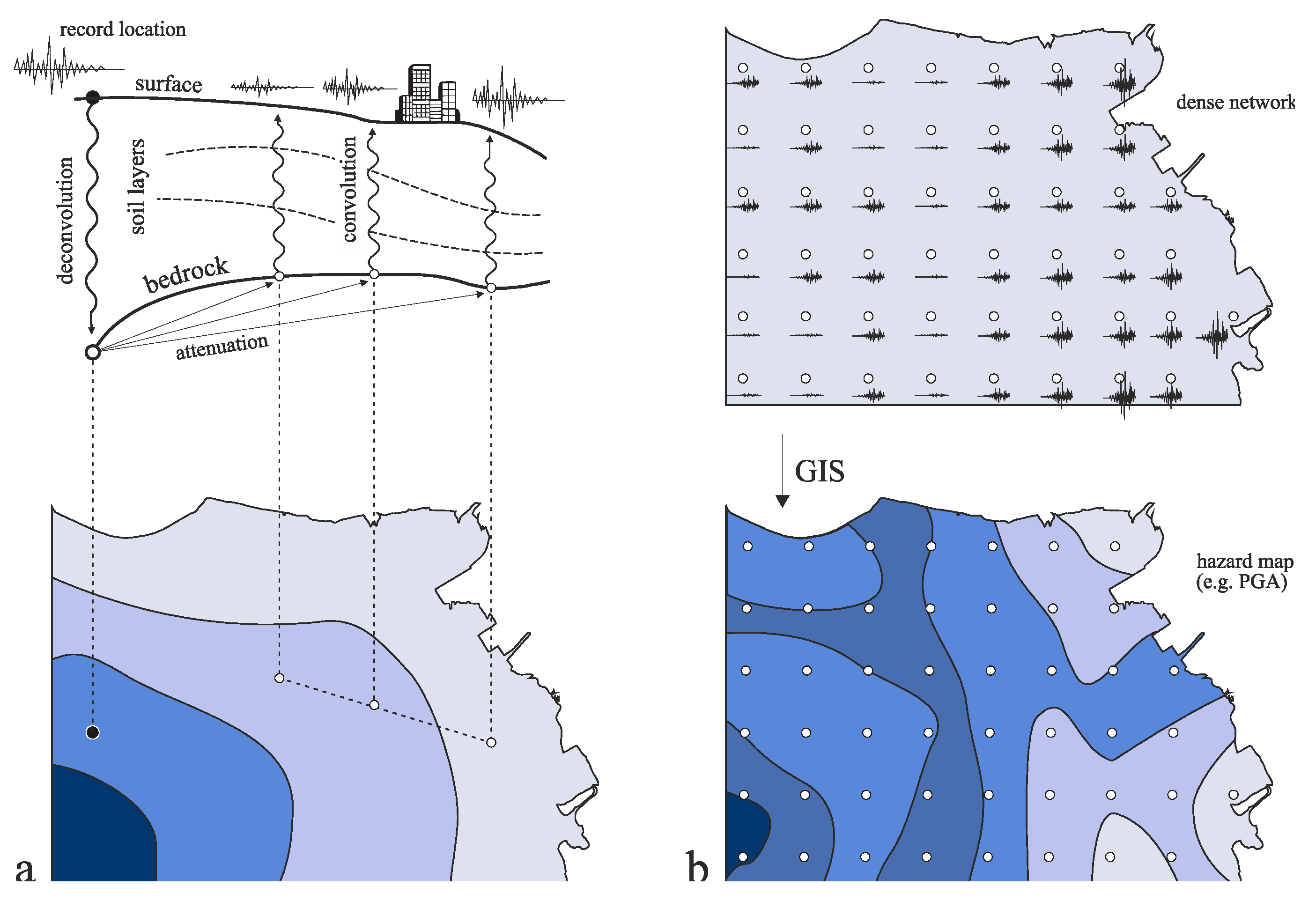
1. Introduction
2. Hardware Development
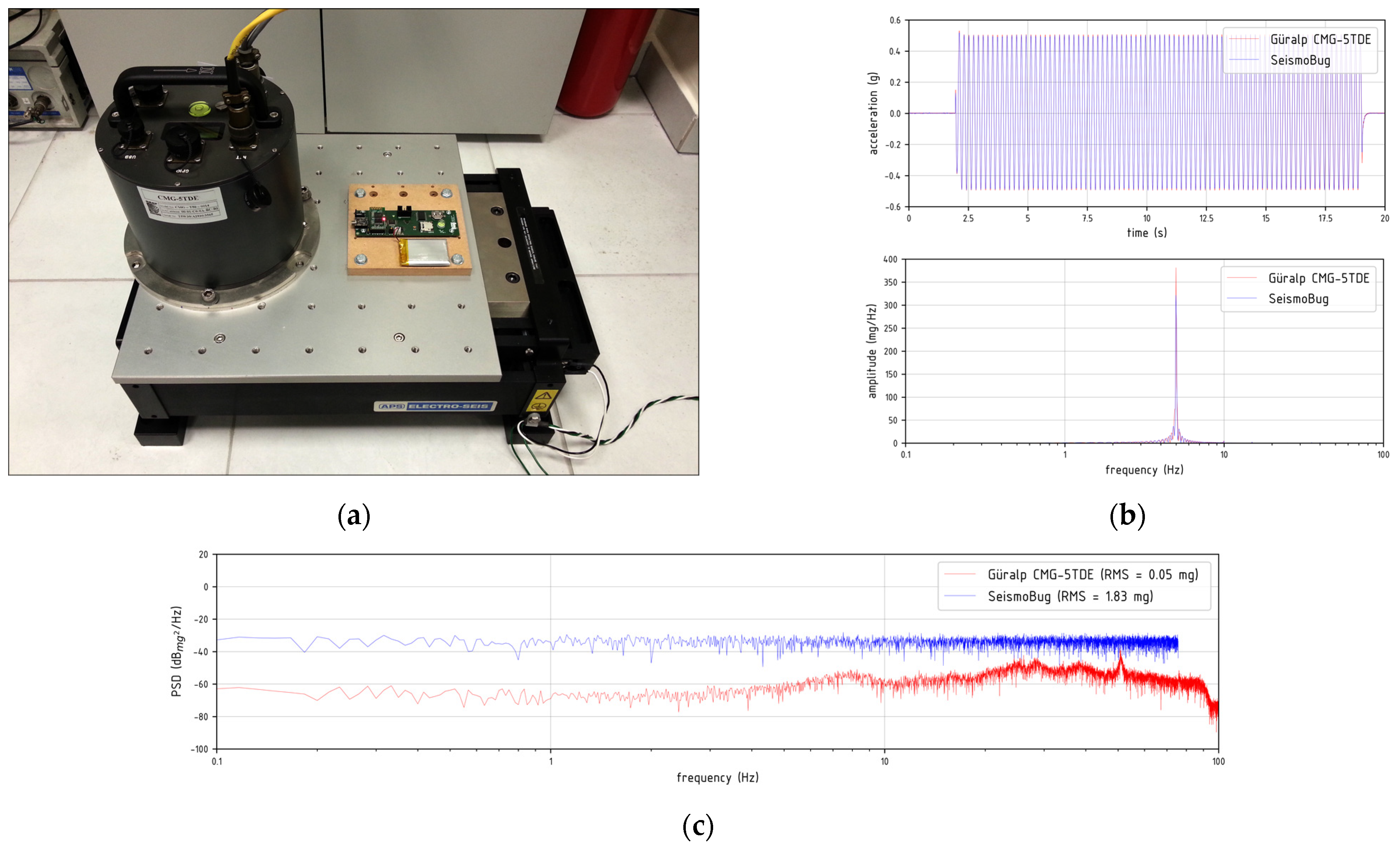
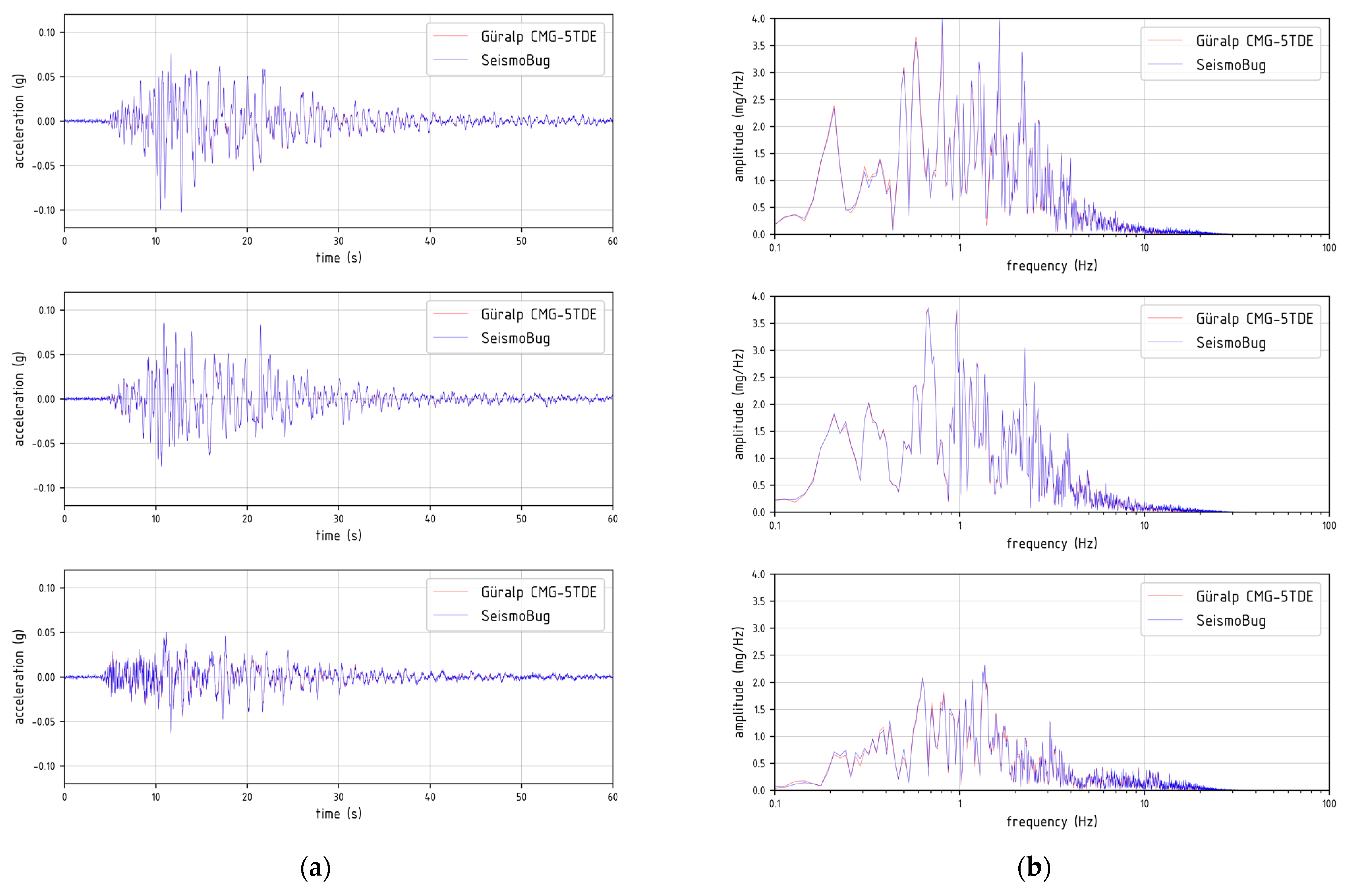
3. Software Development and Device Validation
3.1. SeismoBug© Monitor
3.2. SeismoBug© Browser
3.3. SeismoBug© Manager
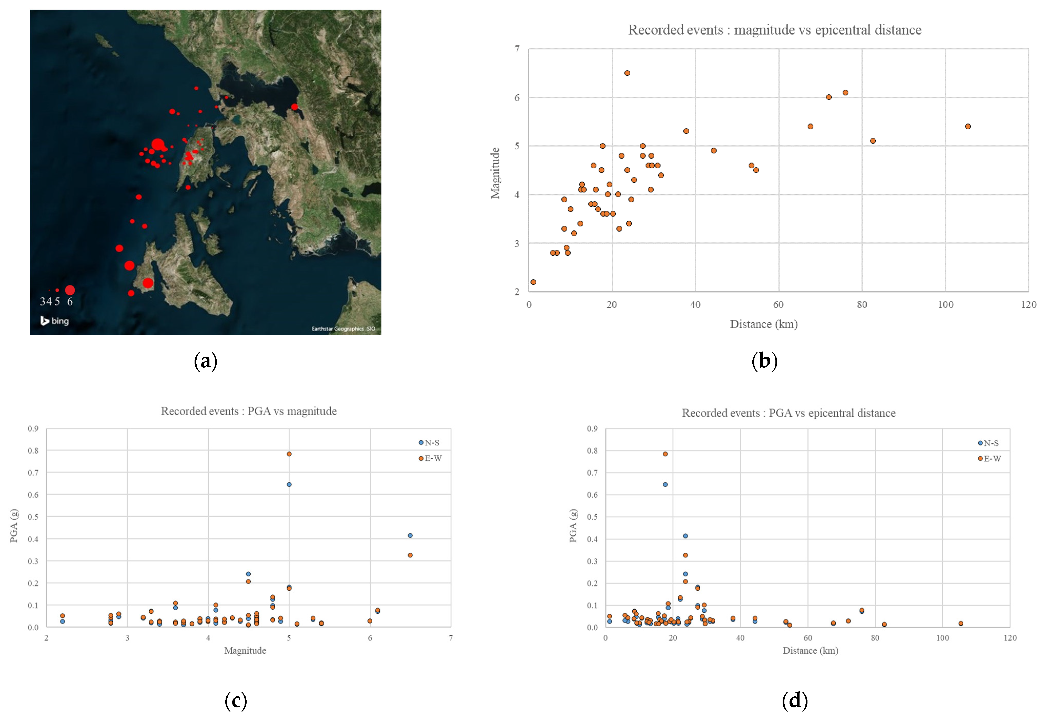
4. System Application
4.1. Installation
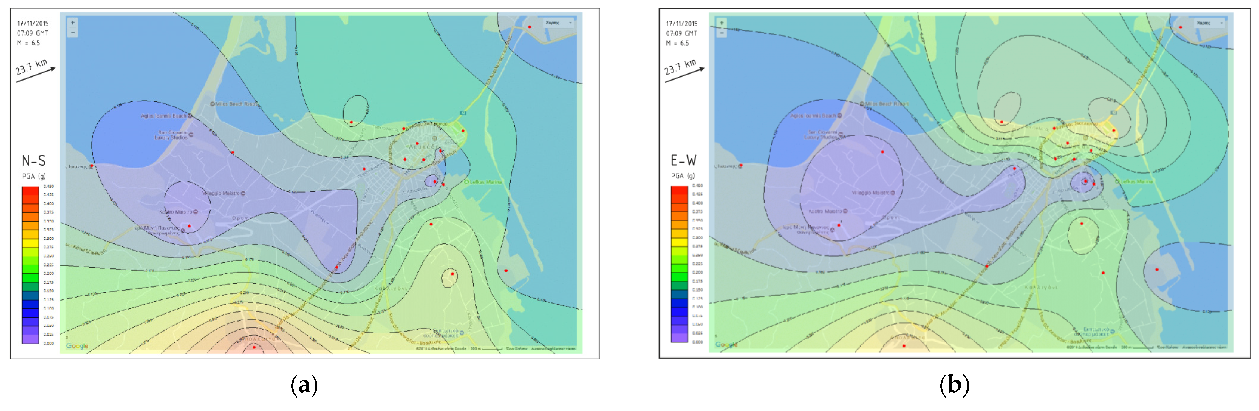
4.2. Network Operation
5. Conclusions and Further Developments
6. Patents
Author Contributions
Funding
Data Availability Statement
Acknowledgments
Conflicts of Interest
References
- Borcherdt, R.D. Effects of local geology on ground motion near San Francisco Bay. Bull. Seismol. Soc. Am. 1970, 60, 29–61. [Google Scholar]
- Seed, H.B.; Schnabel, P.B. Soil and geological effects on site response during earthquakes. In Proceedings of the First International Conference on Microzonation for Safer Construction-Research and Application, Seattle, WA, USA, 30 October–3 November 1972; pp. 61–74. [Google Scholar]
- Eurocode 8: Design of Structures for Earthquake Resistance-Part 1: General Rules, Seismic Actions and Rules for Buildings; CEN (European Committee for Standardization): Brussels, Belgium, 2004; EN1998-1.
- Midorikawa, S.; Abe, S. Real-time assessment of earthquake disaster in Yokohama based on dense strong-motion network. In Proceedings of the 12th World Conference in Earthquake Engineering, Auckland, New Zealand, 30 January–4 February 2000. Paper No. 1036. [Google Scholar]
- Clayton, R.W.; Heaton, T.; Kohler, M.; Chandy, M.; Guy, R.; Bunn, J. Community Seismic Network: A Dense Array to Sense Earthquake Strong Motion. Seismol. Res. Lett. 2015, 86, 1354–1363. [Google Scholar] [CrossRef]
- Avery, H.R.; Berrill, J.B.; Dewe, M.B. Design and development of a low-cost, high-performance, strong-motion accelerograph. In Proceedings of the 2004 NZSEE Conference, Rotorua, New Zealand, 19–21 March 2004. [Google Scholar]
- Picozzi, M.; Milkereit, C.; Parolai, S.; Jäckel, K.H.; Veit, I.; Fischer, J.; Zschau, J. GFZ Wireless Seismic Array (GFZ-WISE), a Wireless Mesh Network of Seismic Sensors: New Perspectives for Seismic Noise Array Investigations and Site Monitoring. Sensors 2010, 10, 3280–3304. [Google Scholar] [CrossRef] [PubMed]
- D’Alessandro, A.; Luzio, D.; D’Anna, G. Urban MEMS based seismic network for post-earthquakes rapid disaster assessment. Adv. Geosci. 2014, 40, 1–9. [Google Scholar] [CrossRef]
- Brooks, B.A.; Baez, J.C.; Ericksen, T.; Barrientos, S.E.; Minson, S.E.; Duncan, C. Smartphone-based earthquake and tsunami early warning in Chile. In Fall Meeting 2016; American Geophysical Union: Washington, DC, USA, 2016; abstract #G31A-1045. [Google Scholar]
- Christensen, B.C.; Blanco Chia, J.F. Raspberry shake-a world-wide citizen seismograph network. In Fall Meeting 2017; American Geophysical Union: Washington, DC, USA, 2017; abstract #S11A-0560. [Google Scholar]
- Bravo-Haro, M.A.; Ding, X.; Elghazouli, A.Y. MEMS-based low-cost and open-source accelerograph for earthquake strong-motion. Eng. Struct. 2021, 230, 111675. [Google Scholar] [CrossRef]
- Wald, D.J.; Quitoriano, V.; Heaton, T.H.; Kanamori, H. Relationships between Peak Ground Acceleration, Peak Ground Velocity and Modified Mercalli Intensity in California. Earthq. Spectra. 1999, 15, 557–564. [Google Scholar] [CrossRef]
- Bosch Sensortec. BMA180 Digital Triaxial Acceleration Sensor Datasheet. Version 2.5. 2010. Available online: https://datasheetspdf.com/datasheet/BMA180.html (accessed on 21 May 2021).
- Tanırcan, G.; Alçık, H.; Beyen, K.H. Reliability of MEMS accelerometers for instrumental intensity mapping of earthquakes. Ann. Geophys. 2017, 60, 673. [Google Scholar] [CrossRef]
- Papanikolaou, V.K.; Karakostas, C.Z. A low cost MEMS-based accelerograph. In Proceedings of the Experimental Vibration Analysis for Civil Engineering Structures (EVACES’13), Ouro Preto, Brazil, 28–30 October 2013; pp. 116–123. [Google Scholar]
- European-Mediterranean Seismological Centre (EMSC). Available online: https://www.emsc-csem.org (accessed on 21 May 2021).
- Galouchko, V. Contour Maps Software 3D Field. Available online: http://3dfmaps.com (accessed on 21 May 2021).
- Karakostas, C.Z.; Papanikolaou, V.K. A low-cost instrumentation approach for seismic hazard assessment in urban areas. In Proceedings of the 9th International Conference on Risk Analysis and Hazard Mitigation, Wessex Institute of Technology, New Forest, UK, 9–11 October 2014. [Google Scholar]
- Karakostas, C.Z.; Papanikolaou, V.K.; Theodoulidis, N.P. An ultra-dense strong-motion urban network based on in-house designed MEMS accelerographs-The case of Lefkas city. In Proceedings of the 16th European Conference on Earthquake Engineering, Thessaloniki, Greece, 18–21 June 2018. [Google Scholar]


| Feature | Description |
|---|---|
| Acceleration sensor | Bosch Sensortec BMA180 14-bit Nominal noise 150 μg/√Hz, measured ≈ 18 mg RMS @ 150 SPS 2nd order Butterworth digital filter at half output data rate |
| Microcontroller | Atmel ATmega328P 3.3V@11.0592 MHz |
| Buffer memory | 1 Mbit SRAM |
| Real-time clock | Battery operated RTC with 2 ppm accuracy (max 0.17 s/day, ≈1 min/year) |
| Local storage | microSD card 2 GB |
| Connectivity | Serial cable or wireless Bluetooth @230.4 Kbps |
| Power | Power supply 5 V/1 A and LiPo backup battery 3.7 V 850 mAh |
| Power consumption | External power: 11.5/53.5/18.5 mA (cable only/BT standby/BT paired) Battery: 7.35/49.5/14.5 mA (cable only/BT standby/BT paired) |
| Dimensions | 120 × 65 × 40 mm |
| Weight | 170 g |
Publisher’s Note: MDPI stays neutral with regard to jurisdictional claims in published maps and institutional affiliations. |
© 2021 by the authors. Licensee MDPI, Basel, Switzerland. This article is an open access article distributed under the terms and conditions of the Creative Commons Attribution (CC BY) license (https://creativecommons.org/licenses/by/4.0/).
Share and Cite
Papanikolaou, V.K.; Karakostas, C.Z.; Theodoulidis, N.P. A Low-Cost Instrumentation System for Seismic Hazard Assessment in Urban Areas. Sensors 2021, 21, 3618. https://doi.org/10.3390/s21113618
Papanikolaou VK, Karakostas CZ, Theodoulidis NP. A Low-Cost Instrumentation System for Seismic Hazard Assessment in Urban Areas. Sensors. 2021; 21(11):3618. https://doi.org/10.3390/s21113618
Chicago/Turabian StylePapanikolaou, Vassilis K., Christos Z. Karakostas, and Nikolaos P. Theodoulidis. 2021. "A Low-Cost Instrumentation System for Seismic Hazard Assessment in Urban Areas" Sensors 21, no. 11: 3618. https://doi.org/10.3390/s21113618
APA StylePapanikolaou, V. K., Karakostas, C. Z., & Theodoulidis, N. P. (2021). A Low-Cost Instrumentation System for Seismic Hazard Assessment in Urban Areas. Sensors, 21(11), 3618. https://doi.org/10.3390/s21113618