Geochemical and Geophysical Monitoring of Hydrocarbon Seepage in the Adriatic Sea †

 ,
,  ,
, 
 , ,
, ,  ,
,  ,
,
Abstract
1. Introduction
2. Materials and Methods
- Determination of gas compounds by headspace gas chromatography using a thermal conductivity detector (GC-TCD), model Agilent Technologies 7890A.
- Measurement of the hydrocarbon index, following the ISO standard procedures UNI EN ISO 9377-2: 2002 [24] with a concentration above 0.1 mg/L. This technique involves the determination by gas chromatography with a flame ionization detector (GC-FID) of the extractable fraction related to hydrocarbons with retention times ranging between n-decane (C10H22) and n-tetracontane (C40H82) excluded.
- Determination of metal composition by a Perkin Elmer OPTIMA 8000 inductively coupled plasma optical emission Spectrometer (ICP-OES) analysis using the APAT CNR–IRSA 3020 method [25].
3. Results
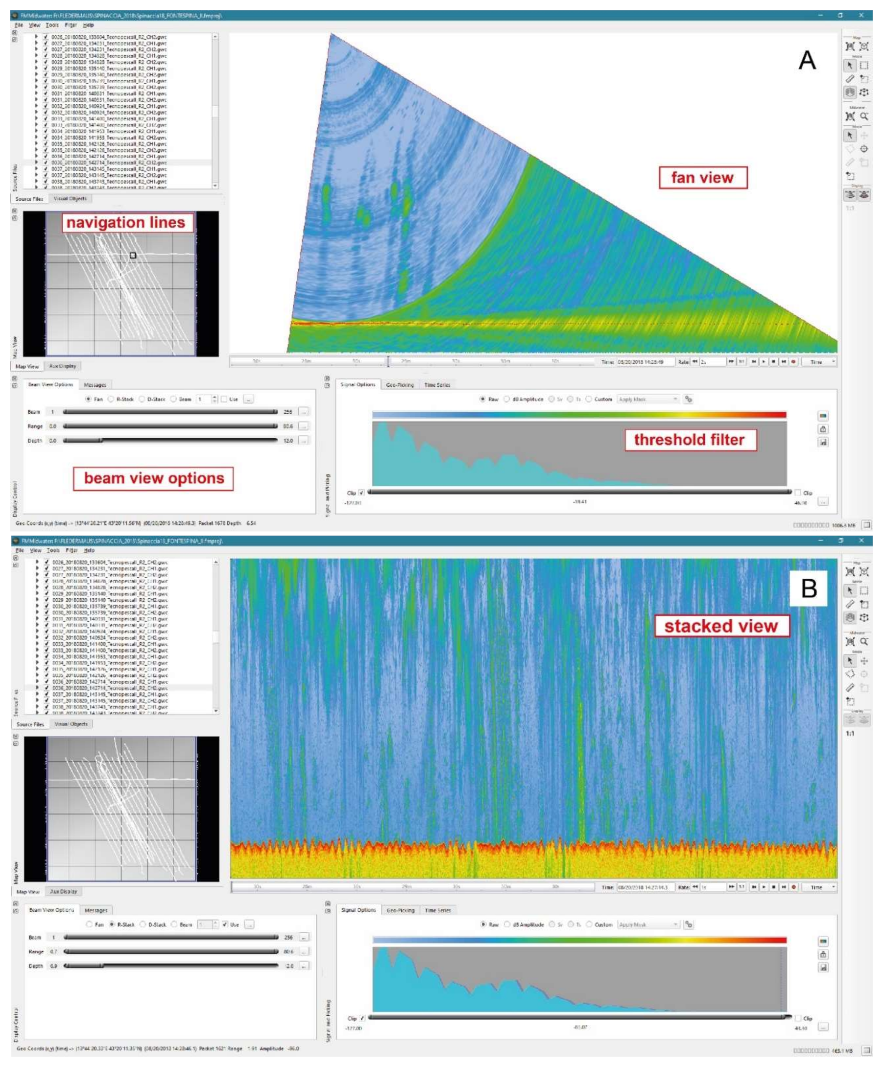
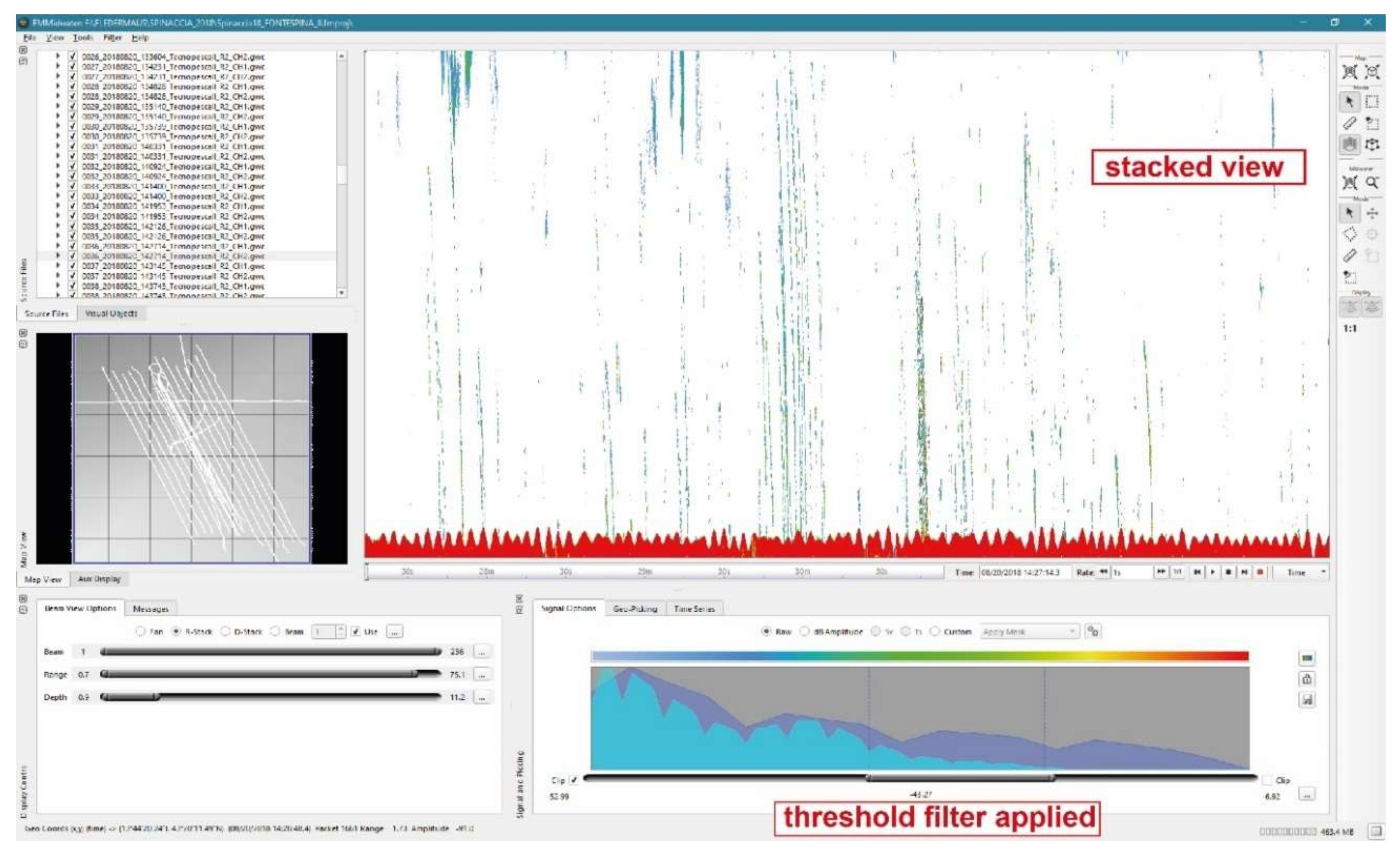
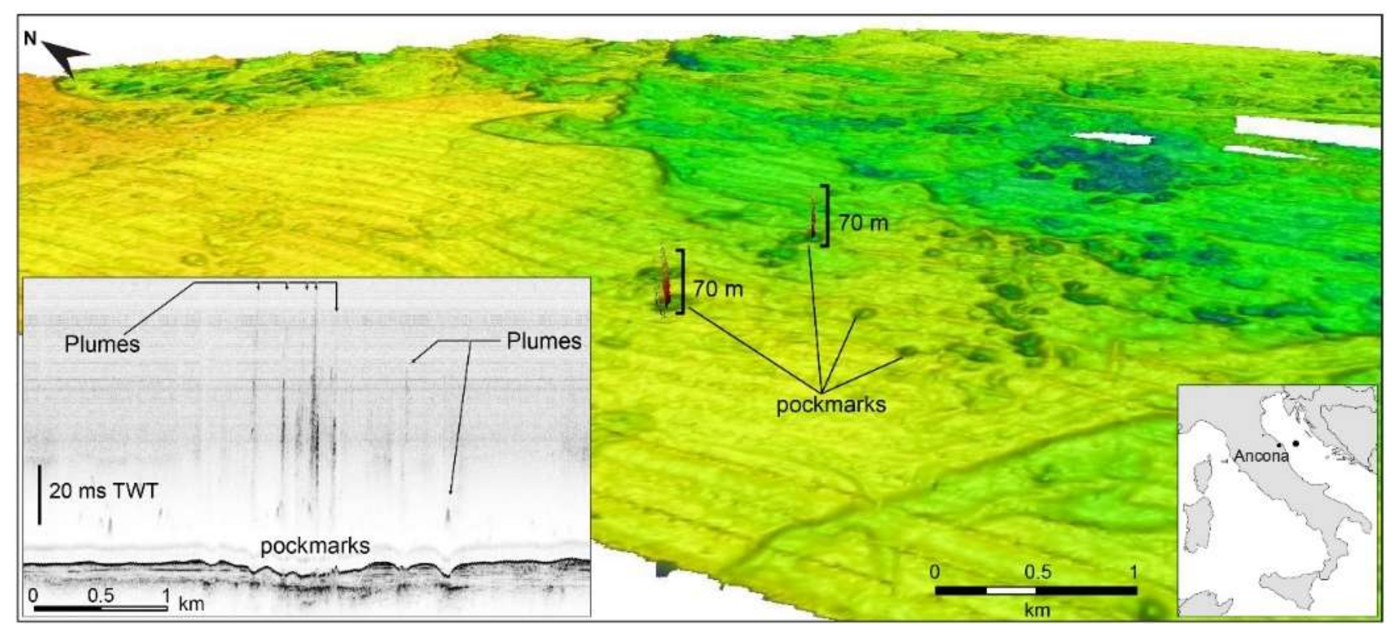
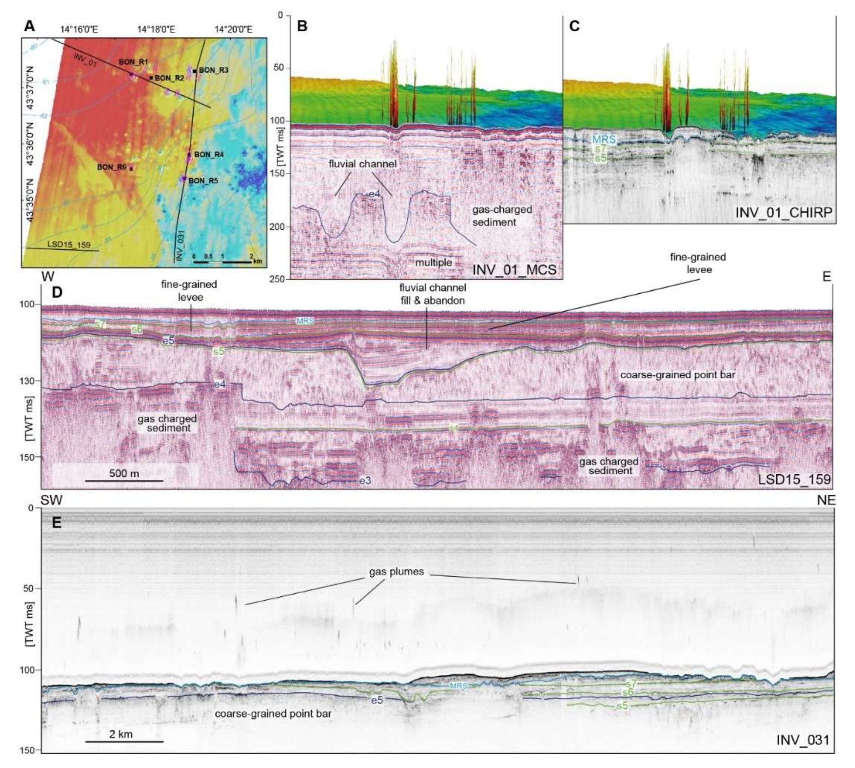
3.1. Reflectivity of the Water Column and Sub-Seafloor Seismic Facies
3.2. Biogeochemistry of the Water Samples
3.3. Geochemistry of the Sediment Samples
4. Discussion
5. Conclusions
- Monitoring of coastal areas, which might be critical when continuously shifting water dynamics due to seasonality and other factors can limit and modify vertical methane and oil migration affecting the variable intensity of discharge on the coast (e.g., Fontespina oil spill).
- Monitoring leakage from abandoned or decommissioned wells and sealines.
- Detecting reservoir leakage through fractures and faults, without expensive 3D seismic acquisitions or tailored re-processing of seismic data.
- Fast detection of upward migration of biogenic methane along the boreholes, originating for example, from shallow gas accumulations that are penetrated when drilling into the underlying deep hydrocarbon reservoir (e.g., [46]).
- De-risking oil & gas exploration by using economic and cost-saving surface probing methods, rather than expensive 3D exploration seismic programs.
Author Contributions
Funding
Acknowledgments
Conflicts of Interest
References
- Picard, K.; Radke, L.C.; Williams, D.K.; Nicholas, W.A.; Justy Siwabessy, P.; Howard, F.J.F.; Gafeira, J.; Przeslawski, R.; Huang, Z.; Nichol, S. Origin of high density seabed pockmark fields and their use in inferring bottom currents. Geosciences 2018, 8, 195. [Google Scholar] [CrossRef]
- Rovere, M.; Gamberi, F.; Mercorella, A.; Rashed, H.; Gallerani, A.; Leidi, E.; Marani, M.; Funari, V.; Pini, G.A. Venting and seepage systems associated with mud volcanoes and mud diapirs in the southern Tyrrhenian Sea. Mar. Geol. 2014, 347, 153–171. [Google Scholar] [CrossRef]
- Hovland, M.; Judd, A.G.; King, L.H. Characteristic features of pockmarks on the North Sea Floor and Scotian Shelf. Sedimentology 1984, 31, 471–480. [Google Scholar] [CrossRef]
- Mazzini, A.; Etiope, G. Mud volcanism: An updated review. Earth-Sci. Rev. 2017, 168, 81–112. [Google Scholar] [CrossRef]
- Paull, C.K.; Hecker, B.; Commeau, R.; Freeman-Lynde, R.P.; Neumann, C.; Corso, W.P.; Golubic, S.; Hook, J.E.; Sikes, E.; Curray, J.T. The first Biological communities at the Florida escarpment resemble hydrothermal vent taxa. Science 1984, 226, 965–967. [Google Scholar] [CrossRef]
- Kennicutt, M.C.; Brooks, J.M.; Bidigare, R.R.; Fay, R.R.; Wade, T.L.; Macdonald, T.J. Vent-type taxa in a hydrocarbon seep region on the Louisiana slope. Nature 1985, 317, 351–353. [Google Scholar] [CrossRef]
- Kvenvolden, K.A. Methane hydrate—A major reservoir of carbon in the shallow geosphere? Chem. Geol. 1988, 71, 41–51. [Google Scholar] [CrossRef]
- Boetius, A.; Wenzhöfer, F. Seafloor oxygen consumption fuelled by methane from cold seeps. Nat. Geosci. 2013, 6, 725–734. [Google Scholar] [CrossRef]
- Stolper, D.; Lawson, M.; Davis, C.L.; Ferreira, A.A.; Santos Neto, E.V.; Ellis, G.S.; Lewan, M.D.; Martini, M.; Tang, Y.; Schoell, M.; et al. Gas formation. Formation temperatures of thermogenic and biogenic methane. Science 2014, 344, 1500–1503. [Google Scholar] [CrossRef]
- Whiticar, M.J. Carbon and hydrogen isotope systematics of bacterial formation and oxidation of methane. Chem. Geol. 1999, 161, 291–314. [Google Scholar] [CrossRef]
- Paull, C.K.; Ussler, W., III; Borowski, W.S.; Spiess, F.N. Methane-rich plumes on the Carolina continental rise: Associations with gas hydrates. Geology 1995, 23, 89–92. [Google Scholar] [CrossRef]
- Chadwick, W.W., Jr.; Merle, S.G.; Buck, N.J.; Lavelle, J.W.; Resing, J.A.; Ferrini, V. Imaging of CO2 bubble plumes above an erupting submarine volcano, NW Rota-1, Mariana Arc. Geochem. Geophyst. Geosyst. 2014, 15, 4325–4342. [Google Scholar] [CrossRef]
- ESDP European Scientific Diving Panel. Available online: http://ssd.imbe.fr/SD-European-Standards?lang=fr (accessed on 17 January 2020).
- Miyazaki, J.; Makabe, A.; Matsui, Y.; Ebina, N.; Tsutsumi, S.; Ishibashi, J.; Chen, C.; Kaneko, S.; Takai, K.; Kawagucci, S. WHATS-3: An improved flow-through multi-bottle fluid sampler for deep-sea geofluid research. Front. Earth Sci. 2017, 5, 45. [Google Scholar] [CrossRef]
- Seewald, J.S.; Doherty, K.W.; Hammar, T.R.; Liberatore, S.P. A new gas-tight isobaric sampler for hydrothermal fluids. Deep-Sea Res. I 2001, 49, 189–196. [Google Scholar] [CrossRef]
- Rovere, M.; Mercorella, A.; Spagnoli, F.; Frapiccini, E.; Funari, V.; Pellegrini, C.; Bonetti, A.S.; Dell’Orso, M.; Mastroianni, M.; Veneruso, T.; et al. Cost-effective and relocatable monitoring of hydrocarbon seepage in offshore environments. In Proceedings of the IMEKO TC-19 International Workshop on Metrology for the Sea—Learning to measure sea health parameters, Genoa, Italy, 3–5 October 2019; IMEKO: Budapest, Hungary, 2019; pp. 64–69. [Google Scholar]
- Etiope, G.; Panieri, G.; Fattorini, D.; Regoli, F.; Vannoli, P.; Italiano, F.; Locritani, M.; Carmisciano, C. A thermogenic hydrocarbon seep in shallow Adriatic Sea (Italy): Gas origin, sediment contamination and benthic foraminifera. Mar. Pet. Geol. 2014, 57, 283–293. [Google Scholar] [CrossRef]
- Benedetti, M.; Gorbi, S.; Fattorini, D.; D’Errico, G.; Piva, F.; Pacitti, D.; Regoli, F. Environmental hazards from natural hydrocarbons seepage: Integrated classification of risk from sediment chemistry, bioavailability and biomarkers responses in sentinel species. Environ. Pollut. 2014, 185, 116–126. [Google Scholar] [CrossRef]
- Taviani, M.; Franchi, F.; Angeletti, L.; Correggiari, A.; López-Correa, M.; Maselli, V.; Mazzoli, C.; Peckmann, J. Biodetrital carbonates on the Adriatic continental shelf imprinted by oxidation of seeping hydrocarbons. Mar. Pet. Geol. 2015, 66, 511–531. [Google Scholar] [CrossRef]
- Capozzi, R.; Guido, F.L.; Oppo, D.; Gabbianelli, G. Methane-Derived Authigenic Carbonates (MDAC) in northern-central Adriatic Sea: Relationships between reservoir and methane seepages. Mar. Geol. 2012, 332–334, 174–188. [Google Scholar] [CrossRef]
- Rovere, M.; Campiani, E.; Leidi, E.; Mercorella, A. Natural hydrocarbon seepage in the Italian offshore. Geoing. Ambient. Min. 2017, LIV 3, 35–40. [Google Scholar]
- Spagnoli, F.; Penna, P.; Giuliani, G.; Masini, L.; Martinotti, V. The AMERIGO Lander and the Automatic Benthic Chamber (CBA): Two New Instruments to Measure Benthic Fluxes of Dissolved Chemical Species. Sensors 2019, 19, 2632. [Google Scholar] [CrossRef]
- Spagnoli, F. Dispositivo di Estrazione del Carbonio Inorganico Disciolto Totale da una Soluzione Acquosa e Sistema di Analisi Comprendente tale Dispositivo. Total Dissolved Inorganic Carbon Extraction Device from Aqueous Solutions and Analysis System Comprising such Device. Industrial Patent No. 10201600004, 3 December 2018. [Google Scholar]
- ISO 9377-2:2000 Water Quality—Determination of Hydrocarbon Oil Index—Part 2: Method Using Solvent extraction and Gas Chromatography. Available online: https://www.iso.org/obp/ui/#iso:std:iso:9377:-2:ed-1:v1:en (accessed on 17 January 2020).
- Belli, M.; Centioli, D.; de Zorzi, P.; Sansone, U.; Capri, S.; Pagnotta, R.; Pettine, M. Metodi Analitici per le Acque; Rapporti 29; APAT: Rome, Italy, 2003; pp. 197–214. Available online: http://www.irsa.cnr.it/Docs/Capitoli/1000.pdf (accessed on 17 January 2020).
- International Conference on Harmonisation of Technical Requirements for Registration of Pharmaceuticals for Human Use. Harmonized Tripartite Guideline, Validation of Analytical Procedure: Text. and Methodologies, Q2(R1). Parent Guideline Version 4, 2005. Available online: https://database.ich.org/sites/default/files/Q2_R1__Guideline.pdf (accessed on 17 January 2020).
- Pellegrini, C.; Asioli, A.; Bohacs, K.M.; Drexler, T.M.; Feldman, H.R.; Sweet, M.L.; Maselli, V.; Rovere, M.; Gamberi, F.; Valle, G.D.; et al. The late Pleistocene Po River lowstand wedge in the Adriatic Sea: Controls on architecture variability and sediment partitioning. Mar. Pet. Geol. 2018, 96, 16–50. [Google Scholar] [CrossRef]
- Trincardi, F.; Correggiari, A.; Roveri, M. Late Quaternary transgressive erosion and deposition in a modern epicontinental shelf: The Adriatic semienclosed basin. Geo. Marine Lett. 1994, 14, 41–51. [Google Scholar] [CrossRef]
- Lambeck, K.; Rouby, H.; Purcell, A.; Sun, Y.; Sambridge, M. Sea level and global ice volumes from the Last Glacial Maximum to the Holocene. Proc. Natl. Acad. Sci. USA 2014, 111, 15296–15303. [Google Scholar] [CrossRef]
- Hammond, D.E.; Cummins, K.M.; McManus, J.; Berelson, W.M.; Smith, G.; Spagnoli, F. A Comparison of Method for Benthic Flux Measurement Along the California Margin. Limnol. Oceanogr. Meth. 2004, 2, 146–159. [Google Scholar] [CrossRef]
- Spagnoli, F.; Dell’Anno, A.; De Marco, A.; Dinelli, E.; Fabiano, M.; Gadaleta, M.V.; Ianni, C.; Loiacono, F.; Manini, E.; Marini, M.; et al. Biogeochemistry, grain size and mineralogy of the central and southern Adriatic Sea sediments: A review. Chem. Ecol. 2010, 26, 19–44. [Google Scholar] [CrossRef]
- Marini, M.; Frapiccini, E. Persistence of polycyclic aromatic hydrocarbons in sediments in the deeper area of the Northern Adriatic Sea (Mediterranean Sea). Chemosphere 2013, 90, 1839–1846. [Google Scholar] [CrossRef]
- Tobiszewski, M.; Namiesnik, J. PAH diagnostic ratios for the identification of pollution emission sources. Environ. Pollut. 2012, 162, 110–119. [Google Scholar] [CrossRef]
- Pérez-Albaladejo, E.; Rizzi, J.; Fernandes, D.; Lille-Langøy, R.; Goksøyr, A.; Oros, A.; Spagnoli, F.; Porte, C. Assessment of the environmental quality of coastal sediments by using a combination of in vitro bioassays. Mar. Pollut. Bull. 2016, 108, 53–61. [Google Scholar] [CrossRef]
- Esposito, V.; Andaloro, F.; Canese, S.; Bortoluzzi, G.; Bo, M.; Di Bella, M.; Italiano, F.; Sabatino, G.; Battaglia, P.; Consoli, P.; et al. Exceptional discovery of a shallow-water hydrothermal site in the SW area of Basiluzzo islet (Aeolian archipelago, South Tyrrhenian Sea): An environment to preserve. PLoS ONE 2018, 13, 1–27. [Google Scholar] [CrossRef]
- Linke, P.; Wallmann, K.; Suessa, E.; Hensenb, C.; Rehder, G. In Situ benthic fluxes from an intermittently active mud volcano at the Costa Rica convergent margin. Earth Planet. Sci. Lett. 2005, 235, 79–95. [Google Scholar] [CrossRef]
- Sommer, S.; Türk, M.; Kriwanek, S.; Pfannkuche, O. Gas exchange system for extended in situ benthic chamber flux measurements under controlled oxygen conditions: First application—Sea bed methane emission measurements at Captain Arutyunov mud volcano. Limnol. Oceanogr. Methods 2008, 6, 23–33. [Google Scholar] [CrossRef]
- Gromet, L.P.; Dymek, R.F.; Haskin, L.A.; Korotev, R.L. The “North American shale composite”: Its compilation, major and trace element characteristics. Geochim. Cosmochim. Ac. 1984, 48, 2469–2482. [Google Scholar] [CrossRef]
- Taylor, S.R.; McLennan, S. Continental Crust: Its Composition and Evolution. An Examination of the Geochemical Record Preserved in Sedimentary Rocks; Blackwell Scientific: Oxford, UK, 1985. [Google Scholar]
- Ianni, C.; Magi, E.; Rivaro, P.; Ruggieri, N. Trace metals in Adriatic coastal sediments: Distribution and speciation pattern. Toxicol. Environ. Chem. 2000, 78, 73–92. [Google Scholar] [CrossRef]
- Bau, M.; Koschinsky, A.; Dulski, P.; Hein, J. Comparison of the partitioning behaviours of yttrium, rare earth elements, and titanium between hydrogenetic marine ferromanganese crusts and seawater. Geochim. Cosmochim. Ac. 1996, 60, 1709–1725. [Google Scholar] [CrossRef]
- Cave, R.R.; German, C.R.; Thomson, J.; Nesbitt, R.W. Fluxes to sediments underlying the Rainbow hydrothermal plume at 36°14’N on the Mid-Atlantic Ridge. Geochim. Cosmochim. Ac. 2002, 66, 1905–1923. [Google Scholar] [CrossRef]
- Pearce, T.J.; Jarvis, I. High-resolution chemostratigraphy of Quaternary distal turbidites: A Case Study of New Methods for the Analysis and Correlation of Barren Sequences. In Non-Biostratigraphical Methods of Dating and Correlation; Special Publications 89; Dunay, R.E., Hailwood, E.A., Eds.; Geological Society: London, UK, 1995; pp. 107–143. [Google Scholar]
- Casero, P. Structural Setting of Petroleum Exploration Plays in Italy. Spec. Vol. Ital. Geol. Soc. 2004, IGC 32 Florence, 189–199. [Google Scholar]
- Mazzini, A.; Jonk, R.; Duranti, D.; Parnell, J.; Cronin, B.; Hurst, A. Fluid escape from reservoirs: Implications from cold seeps, fractures and injected sands Part, I. The fluid flow system. J. Geochem. Explor. 2003, 78–79, 293–296. [Google Scholar] [CrossRef]
- Vielstädte, L.; Karstens, J.; Haeckel, M.; Schmidt, M.; Linke, P.; Reimann, S.; Liebetrau, V.; Mcginnis, D.F.; Wallmann, K. Quantification of methane emissions at abandoned gas wells in the Central North Sea. Mar. Pet. Geol. 2015, 68, 848–860. [Google Scholar] [CrossRef]
- Bayon, G.; Birot, D.; Ruf, L.; Caprais, J.; Ponzevera, E.; Bollinger, C.; Donval, J. Evidence for intense REE scavenging at cold seeps from the Niger Delta margin. Earth Planet. Sci. Lett. 2011, 312, 443–452. [Google Scholar] [CrossRef]
- Greinert, J.; Bollwerk, S.M.; Derkachev, A.; Bohrmann, G.; Suess, E. Massive barite deposits and carbonate mineralization in the Derugin Basin, Sea of Okhotsk: Precipitation processes at cold seep sites. Earth Planet. Sci. Lett. 2002, 203, 165–180. [Google Scholar] [CrossRef]
- Xu, T.; Shang, S.; Tian, H.; Bei, K.; Cao, Y. Numerical Simulation on Authigenic Barite Formation in Marine Sediments. Minerals 2019, 9, 98. [Google Scholar] [CrossRef]
- Wagner, M.; Wagner, M.; Piske, J.; Smit, R. Case Histories of Microbial Prospection for Oil and Gas, Onshore and Offshore in Northwest Europe, in Surface Exploration Case Histories: Applications of Geochemistry, Magnetics, and Remote Sensing. In AAPG Studies in Geology 48 and SEG Geophysical References Series 11; Schumacher, D., LeSchack, L.A., Eds.; AAPG: Houston, TX, USA, 2002; pp. 453–479. [Google Scholar]
- Hostettler, F.D.; Lorenson, T.D.; Bekins, B.A. Petroleum Fingerprinting with Organic Markers Petroleum Fingerprinting with Organic Markers. Environ. Forensics 2013, 14, 262–277. [Google Scholar] [CrossRef]


| Calibration Curve (ICP) | |||
|---|---|---|---|
| Metals | Point 1 (ppm) | Point 2 (ppm) | Point 3 (ppm) |
| STD 21 (Cd, Cr, Cu, Pb, Mn, As, Be, Se, Co, Ni, Zn, V) | 0.01 | 0.1 | 0.5 |
| Fe, B, Ba, Al | 0.1 | 1 | 10 |
| Sn | 0.01 | 0.1 | 0.5 |
| Dissolved Benthic Fluxes (mmol/m2*d) | |||
|---|---|---|---|
| Site | Oxygen | DIC | H+ |
| Fontespina | −51.53 | 42 | 2e−0.7 |
| Central Adriatic Sea 1 | -39 | 9.38 | n.d. |
| C10–C40 | |
|---|---|
| Sample | mg/L |
| 0 I | 28.6 |
| 1 I | 36.9 |
| 3 I | <L.R |
| 4 I | 0.56 |
| 5 I | 2.47 |
| 6 I | 2.03 |
| 7 I | <L.R |
| Values (mg/L) | |||||||
|---|---|---|---|---|---|---|---|
| Metal Species | 0 I | 1 I | 3 I | 4 I | 5 I | 6 I | 7 I |
| Al | <D.L. | <D.L. | <D.L. | <D.L. | <D.L. | <D.L. | <D.L. |
| Cd | <D.L. | <D.L. | <D.L. | <D.L. | <D.L. | <D.L. | <D.L. |
| Cr | <D.L. | <D.L. | <D.L. | <D.L. | <D.L. | <D.L. | <D.L. |
| Cu | <D.L. | <D.L. | <D.L. | <D.L. | <D.L. | <D.L. | <D.L. |
| Pb | <D.L. | <D.L. | 0.0468 | <D.L. | 0.0190 | 0.0228 | <D.L. |
| Mn | <D.L. | <D.L. | <D.L. | <D.L. | <D.L. | <D.L. | <D.L. |
| As | <D.L. | <D.L. | <D.L. | <D.L. | <D.L. | <D.L. | <D.L. |
| B | 4.1744 | 5.3180 | 4.5720 | 3.8472 | 5.2658 | 5.3828 | 4.1482 |
| Ba | <D.L. | <D.L. | <D.L. | <D.L. | <D.L. | <D.L. | <D.L. |
| Be | <D.L. | <D.L. | <D.L. | <D.L. | <D.L. | <D.L. | <D.L. |
| Co | <D.L. | <D.L. | <D.L. | <D.L. | <D.L. | <D.L. | <D.L. |
| Fe | <D.L. | <D.L. | <D.L. | <D.L. | <D.L. | <D.L. | <D.L. |
| Ni | <D.L. | <D.L. | <D.L. | <D.L. | <D.L. | <D.L. | <D.L. |
| Se | <D.L. | <D.L. | <D.L. | <D.L. | <D.L. | <D.L. | <D.L. |
| Sn | 0.0636 | 0.0632 | 0.0632 | 0.0632 | 0.0632 | 0.0632 | 0.0632 |
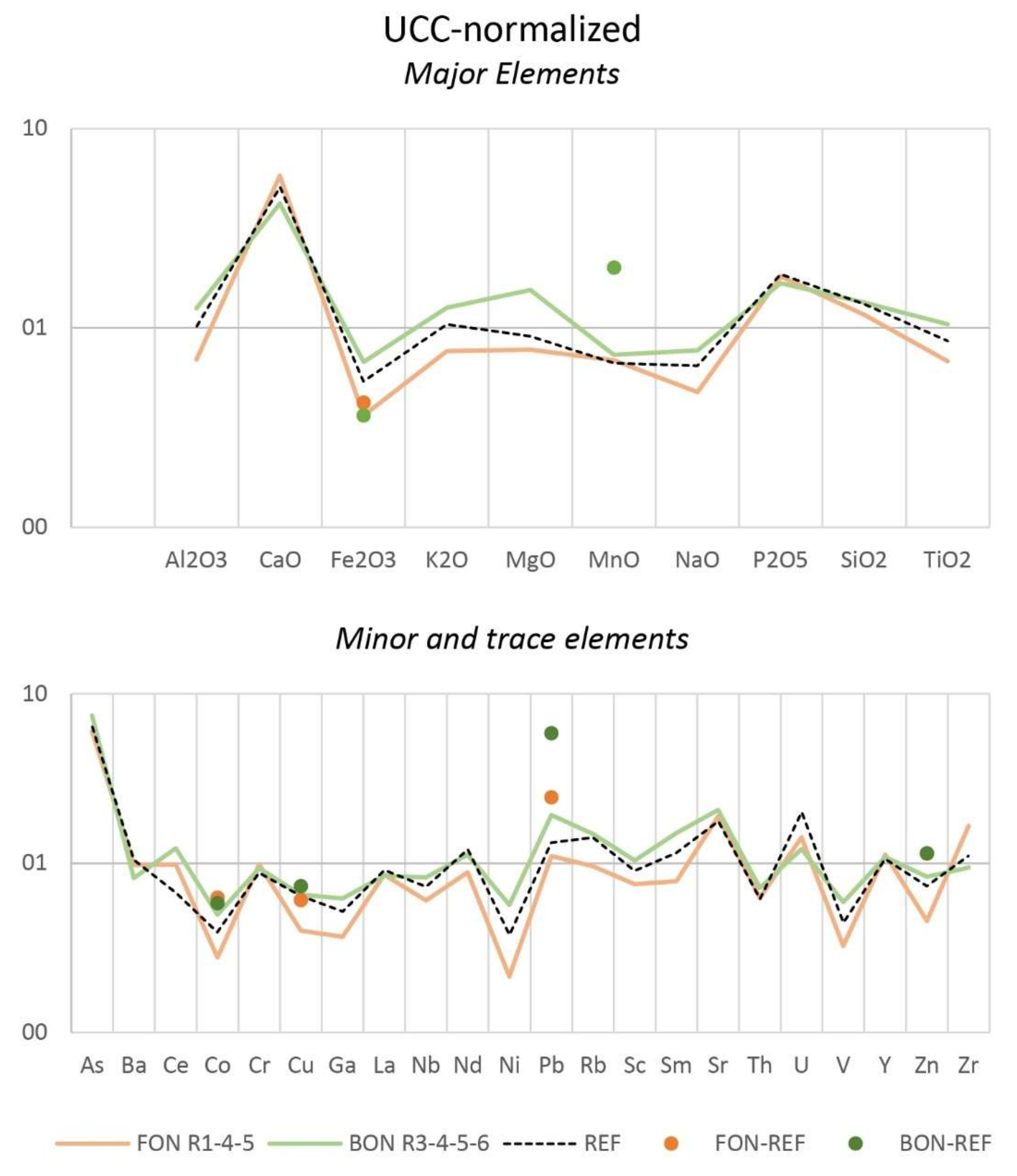
| Element | REF | FON_R1 | FON_R4 | FON_R5 | BON_R3 | BON_R4 | BON_R5 | BON_R6 |
|---|---|---|---|---|---|---|---|---|
| wt.% | ||||||||
| Al2O3 | 8.24 | 5.46 | 5.29 | 6.12 | 8.98 | 10.81 | 10.22 | 10.67 |
| CaO | 25.41 | 29.34 | 29.37 | 28.22 | 22.99 | 19.31 | 21.85 | 20.14 |
| Fe2O3 | 3.36 | 2.25 | 2.2 | 2.34 | 3.67 | 4.47 | 4.15 | 4.5 |
| K2O | 1.56 | 1.15 | 1.13 | 1.17 | 1.62 | 2.13 | 1.87 | 1.98 |
| MgO | 2.57 | 2.16 | 2.11 | 2.33 | 4.33 | 4.64 | 3.89 | 4.7 |
| MnO | 0.1 | 0.1 | 0.11 | 0.1 | 0.09 | 0.1 | 0.09 | 0.16 |
| NaO | 1.58 | 0.96 | 0.76 | 1.78 | 1.76 | 0.94 | 2.95 | 1.91 |
| P2O5 | 0.13 | 0.13 | 0.13 | 0.12 | 0.11 | 0.13 | 0.11 | 0.12 |
| SiO2 | 36.89 | 33 | 32.46 | 32.25 | 34.54 | 38.95 | 36.97 | 39.55 |
| TiO2 | 0.43 | 0.33 | 0.32 | 0.37 | 0.47 | 0.52 | 0.55 | 0.55 |
| LOI | 21.08 | 22.18 | 22.18 | 22.38 | 22.98 | 20.87 | 21.82 | 20.39 |
| mg/kg | ||||||||
| As | 9.6 | 9.4 | 8.8 | 8.9 | 10.6 | 10.5 | 8 | 15.5 |
| Ba | 277 | 253 | 267 | 258 | 188 | 240 | 215 | 224 |
| Bi | 0.4 | 0.5 | 0.4 | 0.5 | 0.5 | 0.5 | 0.5 | 0.5 |
| Br | 15.1 | 18.1 | 12.1 | 44.4 | 25.7 | 23.8 | 28.9 | 29 |
| Ce | 26.9 | 40.7 | 43.9 | 33.2 | 34 | 53.2 | 48.8 | 59.8 |
| Cl | 4948 | 3880 | 2015 | 9224 | 4828 | 1716 | 8378 | 4724 |
| Co | 9.8 | 6.1 | 9.2 | 5.5 | 11.1 | 13.5 | 13.1 | 12 |
| Cr | 158 | 170 | 183 | 177 | 160 | 170 | 155 | 187 |
| Cu | 16 | 10.1 | 9.2 | 10.7 | 11.7 | 19.4 | 16.7 | 17.4 |
| Ga | 8.8 | 6.6 | 6.4 | 5.8 | 8.8 | 11.4 | 10.7 | 11.2 |
| La | 18.2 | 20 | 14.1 | 17.3 | 17.2 | 20.7 | 15.2 | 14.5 |
| Nb | 8 | 6.4 | 6.7 | 6.8 | 8.1 | 9.5 | 9.7 | 9 |
| Nd | 24.1 | 19.2 | 20.3 | 13.5 | 11.2 | 24 | 25 | 29.7 |
| Ni | 39.6 | 23.2 | 22.6 | 21.9 | 47.9 | 68 | 58.6 | 64.3 |
| Pb | 13.2 | 10.9 | 12.7 | 9.5 | 16.7 | 19.5 | 19.1 | 21.8 |
| Rb | 70.9 | 47.7 | 47.4 | 48.6 | 58.8 | 80.7 | 78.5 | 79.8 |
| S | 1047 | 904 | 778 | 1747 | 752 | 596 | 809 | 574 |
| Sc | 12.6 | 15.7 | 5.5 | 10.4 | 1 | 17.6 | 23.1 | 16.5 |
| Sm | 4.6 | 3.3 | 3.2 | 2.9 | 5 | 6.5 | 6.2 | 6.4 |
| Sr | 424 | 462 | 453 | 446 | 547 | 453 | 527 | 451 |
| Th | 3.5 | 4 | 3.3 | 3.4 | 2.7 | 3.4 | 5.3 | 4.9 |
| U | 3 | 2.7 | 1.5 | 2.2 | 1.4 | 1.5 | 2 | 2.4 |
| V | 86.9 | 59.2 | 60.1 | 70.7 | 96.3 | 126 | 113 | 124 |
| Y | 19.1 | 20.1 | 20.3 | 20.1 | 18.2 | 20.5 | 20.9 | 18.8 |
| Zn | 52.1 | 32.5 | 31.1 | 33.9 | 44.9 | 67.2 | 61.2 | 62.5 |
| Zr | 138 | 186 | 206 | 231 | 120 | 115 | 131 | 105 |
© 2020 by the authors. Licensee MDPI, Basel, Switzerland. This article is an open access article distributed under the terms and conditions of the Creative Commons Attribution (CC BY) license (http://creativecommons.org/licenses/by/4.0/).
Share and Cite
Rovere, M.; Mercorella, A.; Frapiccini, E.; Funari, V.; Spagnoli, F.; Pellegrini, C.; Bonetti, A.S.; Veneruso, T.; Tassetti, A.N.; Dell’Orso, M.; et al. Geochemical and Geophysical Monitoring of Hydrocarbon Seepage in the Adriatic Sea. Sensors 2020, 20, 1504. https://doi.org/10.3390/s20051504
Rovere M, Mercorella A, Frapiccini E, Funari V, Spagnoli F, Pellegrini C, Bonetti AS, Veneruso T, Tassetti AN, Dell’Orso M, et al. Geochemical and Geophysical Monitoring of Hydrocarbon Seepage in the Adriatic Sea. Sensors. 2020; 20(5):1504. https://doi.org/10.3390/s20051504
Chicago/Turabian StyleRovere, Marzia, Alessandra Mercorella, Emanuela Frapiccini, Valerio Funari, Federico Spagnoli, Claudio Pellegrini, Andree Soledad Bonetti, Tiziana Veneruso, Anna Nora Tassetti, Marcello Dell’Orso, and et al. 2020. "Geochemical and Geophysical Monitoring of Hydrocarbon Seepage in the Adriatic Sea" Sensors 20, no. 5: 1504. https://doi.org/10.3390/s20051504
APA StyleRovere, M., Mercorella, A., Frapiccini, E., Funari, V., Spagnoli, F., Pellegrini, C., Bonetti, A. S., Veneruso, T., Tassetti, A. N., Dell’Orso, M., Mastroianni, M., Giuliani, G., De Marco, R., Fabi, G., Ciccone, F., & Antoncecchi, I. (2020). Geochemical and Geophysical Monitoring of Hydrocarbon Seepage in the Adriatic Sea. Sensors, 20(5), 1504. https://doi.org/10.3390/s20051504