Linking Spatio-Temporal Land Cover Change to Biodiversity Conservation in the Koshi Tappu Wildlife Reserve, Nepal
Abstract
:1. Introduction
2. Methods
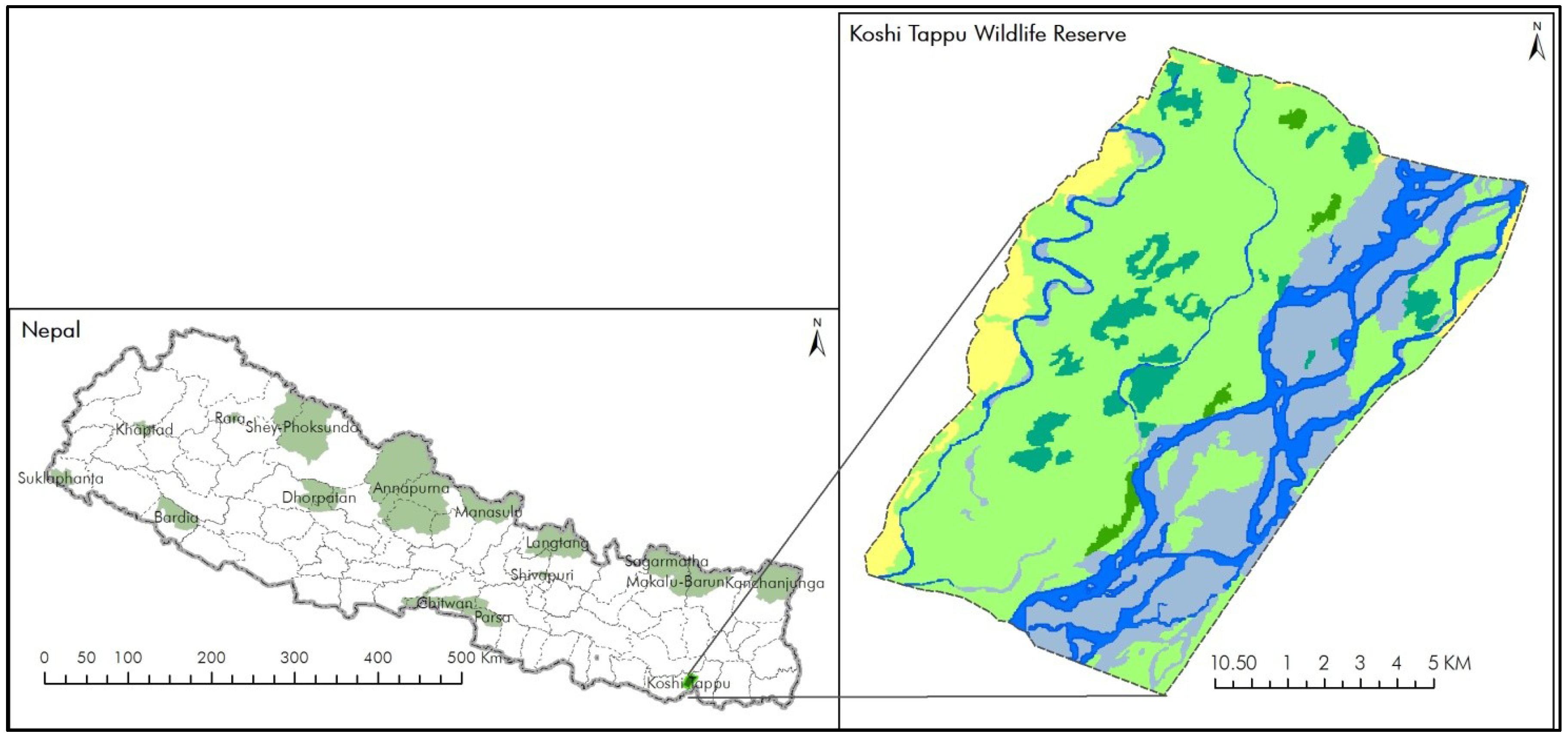
2.1. Site Description

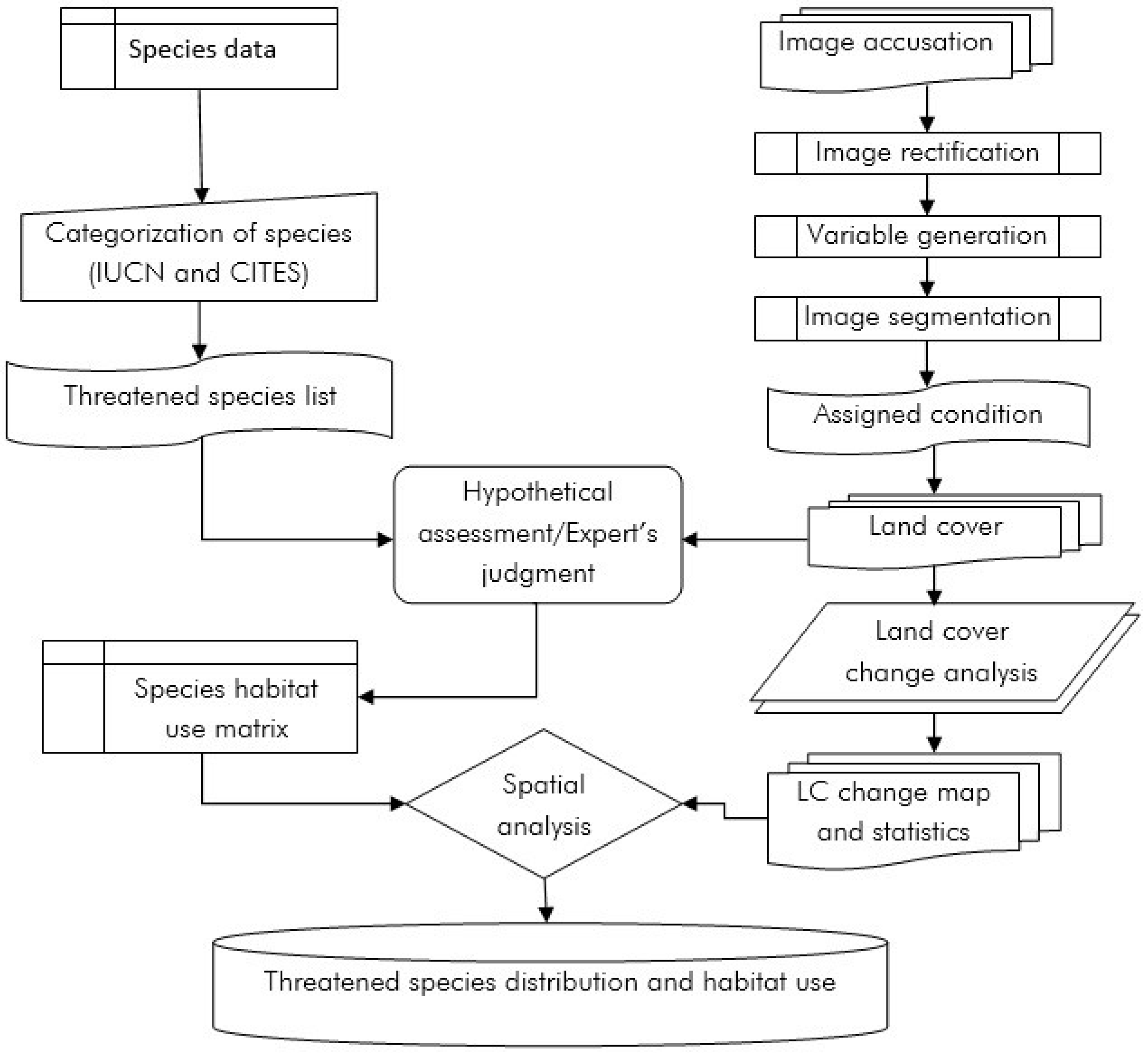
2.2. Land Covers Change Analysis
| Sl No | Satellite | Senior | Path | Row | Acquisition date |
|---|---|---|---|---|---|
| 1 | Landsat | MSS | 150 | 42 | 13 November 1976 |
| 2 | Landsat | TM | 140 | 40 | 17 January 1989 |
| 3 | Landsat | ETM+ | 140 | 40 | 28 October 1999 |
| 4 | Landsat | TM | 140 | 40 | 04 February 2010 |

2.3. Habitat Mapping
| Species | Status | Land use | ||||||
|---|---|---|---|---|---|---|---|---|
| IUCN | CITES | Grassland | Swamps/Marshes | Forests | Rivers/Lakes | Sand/gravels | Agri-culture | |
| Wild Water Buffalo (Bubalus bubalis arnee) | EN | III | + | + | + | |||
| Ganges River Dolphin (Platanista gangetica) | VU | I | + | |||||
| Black Giant Squirrel (Ratufa bicolor) | NT | I | + | + | ||||
| Hog Deer (Axis porcinus) | EN | I | + | + | ||||
| Smooth Coated Otter (Lutrogale perspicillata) | VU | II | + | + | + | |||
| Fishing Cat (Prionailurus viverrinus) | EN | II | + | + | + | |||
| Asiatic Elephant (Elephas maximus) | EN | I | + | + | + | |||
| Indian Bison or Gaur (Bos gaurus) | VU | I | + | + | ||||
| Spotted Leopard (Panthera pardus) | NT | I | + | + | ||||
| Gharial (Gavialis gangeticus) | CR | I | + | + | ||||
| Mugger Crocodile (Crocodylus palustris) | VU | I | + | + | ||||
| Rock Python (Python molurus) | NT | II | + | + | + | + | + | |
| King Cobra (Ophiophagus hannah) | VU | II | + | + | + | |||
| Red-crowned Roof Turtle (Kachuga kachuga) | CR | II | + | + | + | + | ||
| Elongated Tortoise (Indotestudo elongata) | EN | II | + | + | + | + | ||
| Indian Softshell Turtle (Aspederetes gangeticus) | VU | I | + | + | ||||
| Greater Adjutant (Leptoptilos dubius) | EN | + | + | + | + | |||
| Pallas’s Fish Eagle (Haliaeetus leucoryphus) | VU | II | + | + | + | |||
| Bengal Florican (Houbaropsis bengalensis) | CR | I | + | + | ||||
| Swamp Francolin (Francolinus gularis) | VU | III | + | + | + | + | + | |
3. Results
3.1. Land Cover Change
| Land cover and ecosystems | 1976 | 1989 | 1999 | 2010 | Change between 1976-2010 |
|---|---|---|---|---|---|
| Agriculture | 1853 (12) | 408 (3) | 608 (4) | 774 (5) | −1079 (−7.2) |
| Forest | 2507 (17) | 180 (1) | 736 (5) | 150 (1) | −2357 (−15.7) |
| Grassland | 1716 (11) | 6632 (44) | 7744 (51) | 8409 (56) | +6693 (+44.5) |
| Lake/pond | 1 (0.01) | 9 (0.06) | 2 (0.01) | 2 (0.01) | +1 (+0.01) |
| Marshes/swamps | 1282 (9) | 1877 (13) | 1087 (7) | 822 (6) | −460 (−3.06) |
| River/stream | 3620 (24) | 1428 (9) | 2567 (17) | 1546 (10) | −2074 (−13.8) |
| Sand/gravel | 4066 (27) | 4512 (30) | 2301 (15) | 3342 (22) | −724 (4.8) |
| Total | 15045 | 15045 | 15045 | 15045 |
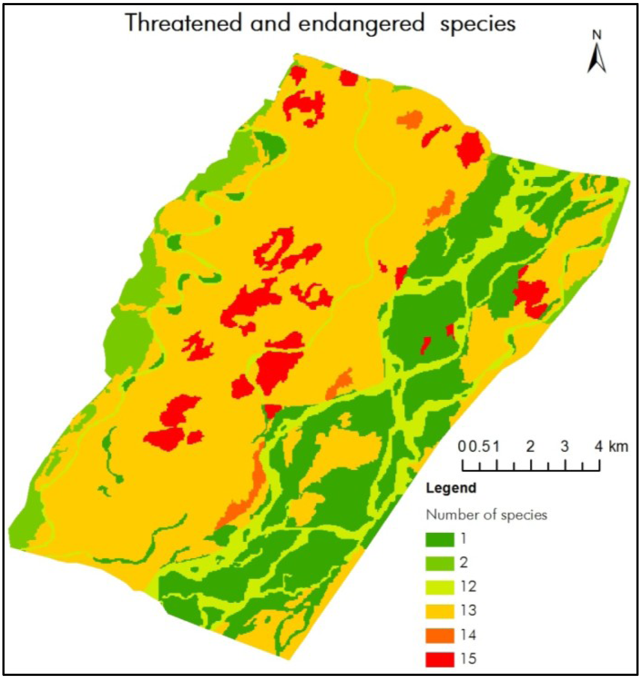
3.2. Distribution Pattern of Threatened Species


3.3. Land Cover Change and Its Potential Impact on Biodiversity
4. Discussion
5. Conclusions
Acknowledgements
Conflict of Interest
References
- Lambin, E.; Turner, B.; Geist, H.; Agbola, S.; Angelsen, A.; Bruce, J.; Coomes, O.; Dirzo, R.; Fischer, G.; Folke, C. The causes of land-use and land-cover change: moving beyond the myths. Global Environ. Change 2001, 11, 261–269. [Google Scholar]
- Pettorelli, N.; Vik, J.O.; Mysterud, A.; Gaillard, J.M.; Tucker, C.J.; Stenseth, N.C. Using the satellite-derived NDVI to assess ecological responses to environmental change. Trends Ecol. Evol. 2005, 20, 503–510. [Google Scholar] [CrossRef]
- Turner, B.L.; Lambien, E.F.; Reenberg, A. The emergence of land change science for global environmental change and sustainability. Proc. Natl. Acad. Sci. USA. 2007, 104, 20666–20671. [Google Scholar] [CrossRef]
- Hooper, D.U.; Adair, E.C.; Cardinale, B.J.; Byrnes, J.E.K.; Hungate, B.A.; Matulich, K.L.; Gonzalez, A.; Duffy, J.E.; Gamfeldt, L.; O’Connor, M.I. A global synthesis reveals biodiversity loss as a major driver of ecosystem change. Nature 2012, 486, 105–108. [Google Scholar]
- Dudgeon, D. The Ecology of Tropical Asian Rivers and Streams in Relation to Biodiversity Conservation. Annu. Rev. Ecol. Syst. 2000, 31, 239–263. [Google Scholar] [CrossRef]
- Haines, Y.R. Land use and biodiversity relationships. Land Use Policy 2009, 26S, S178–S186. [Google Scholar] [CrossRef]
- MA (Millennium Ecosystem Assessment). In Ecosystems and Human Well‐being: Synthesis; Published for World Resources Institute, Island Press: Washington, DC, USA, 2005.
- Sarma, P.K.; Lahkar, B.P.; Ghosh, S.; Rabha, A.; Das, J.P.; Nath, N.K.; Dey, S.; Brahma, N. Land-use and land-cover change and future implication analysis in Manas National Park, India using multi-temporal satellite data. Curr. Sci. India 2008, 95, 223–227. [Google Scholar]
- Berg, R.A.; Warren, Y.; Nicholas, A.; Dunn, A.; Imong, I.; Sunderland-Groves, J.L.; Oates, J.F. Remote sensing analysis reveals habitat, dispersal corridors and expanded distribution for the Critically Endangered Cross River gorilla Gorilla gorilla diehli. Oryx 2011, 46, 278–289. [Google Scholar]
- Chapin, F.S., III; Zavaleta, E.S.; Eviner, V.T.; Naylor, R.L.; Vitousek, P.M.; Reynolds, H.L.; Hooper, D.U.; Lavorel, S.; Sala, O.E.; Hobbie, S.E.; et al. Consequences of changing biodiversity. Nature 2000, 405, 234–242. [Google Scholar]
- Sala, O.E.; Chapin, F.S., III; Armesto, J.J.; Berlow, E.; Bloomfield, J.; Dirzo, R.; Huber-Sanwald, E.; Huenneke, L.F.; Jackson, R.B.; Kinzig, A.; et al. Global biodiversity scenarios for the year 2100. Science 2000, 287, 1770–1774. [Google Scholar]
- Chettri, N.; Shakya, B.; Thapa, R.; Sharma, E. Status of a protected area system in the Hindu Kush-Himalayas: An analysis of PA coverage. Int. J. Biodivers. Sci. Manag. 2008, 4, 164–178. [Google Scholar] [CrossRef]
- Joppa, L.N.; Pfaff, A. Global protected area impacts. Proc. R. Soc. B 2010, 278, 1633–1638. [Google Scholar] [CrossRef]
- Pandit, M.; Sodhi, N.; Koh, L.; Bhaskar, A.; Brook, B. Unreported yet massive deforestation driving loss of endemic biodiversity in Indian Himalaya. Biodivers. Conserv. 2007, 16, 153–163. [Google Scholar] [CrossRef]
- Rodríguez-Rodríguez, D.; Bomhard, B.; Butchart, S.H.M.; Foster, M.N. Progress towards international targets for protected area coverage in mountains: A multi-scale assessment. Biol. Conserv. 2011, 144, 2978–2983. [Google Scholar] [CrossRef]
- Cincotta, R.; Wisnewski, J.; Engelman, R. Human population in the biodiversity hotspots. Nature 2000, 404, 990–992. [Google Scholar] [CrossRef]
- Bawa, K.; Rose, J.; Ganeshaiah, K.N.; Barve, N.; Kiran, M.C.; Umashaanker, R. Assessing biodiversity from space: An example from the Western Ghats, India. Conserv. Ecol. 2002, 6, 7. [Google Scholar]
- Defries, R.; Hansen, A.; Turner, B.L.; Reid, R.; Liu, J. Land use change around protected areas: management to balance human needs and ecological function. Ecol. Appl. 2007, 17, 1031–1038. [Google Scholar]
- Lepers, E.; Lamin, E.F.; Janetos, A.C.; DeFries, R.; Achard, F.; Ramankutty, N.; Scholes, R.J. A synthesis of information on rapid land-cover change for the period 1891–2000. BioScience 2005, 55, 115–124. [Google Scholar]
- Gauthier, P.; Foulon, Y.; Jupille, O.; Thompson, J.D. Quantifying habitat vulnerability to assess species priorities for conservation management. Biol. Conserv. 2013, 158, 321–325. [Google Scholar]
- Kollár, S.; Vekerdy, Z.; Márkus, B. Forest Habitat Change Dynamics in a Riparian Wetland. Procedia. Environ. Sci. 2011, 7, 371–376. [Google Scholar] [CrossRef]
- Yue, T.X.; Liu, J.Y.; Jørgensen, S.E.; Ye, Q.H. Landscape change detection of the newly created wetland in Yellow River Delta. Ecol. Model. 2003, 164, 21–31. [Google Scholar] [CrossRef]
- Zomer, R.J.; Ustin, S.L.; Carpenter, C.C. Land Cover Change Along Tropical and Subtropical Riparian Corridors Within the Makalu Barun National Park and Conservation Area, Nepal. Mt. Res. Dev. 2001, 21, 175–183. [Google Scholar] [CrossRef]
- Dudgeon, D.; Arthington, A.H.; Gessner, M.O.; Kawabata, Z.; Knowler, D.J; Lévêque, C.; Naiman, R.J.; Prieur-Richard, A.; Soto, D.; Stiassny, M.L.J.; et al. Freshwater biodiversity: Importance, threats, status and conservation challenges. Biol. Rev. 2006, 81, 163–182. [Google Scholar]
- Grumbine, R.E.; Pandit, M.K. Threats from India’s Himalaya Dams. Science 2013, 339, 36–37. [Google Scholar] [CrossRef]
- LaRue, M.A.; Nielsen, C.K. Modelling potential dispersal corridors for cougars in midwestern North America using least-cost path methods. Ecol. Model. 2008, 212, 372–381. [Google Scholar] [CrossRef]
- Macauley, M.K. Earth observations in social science research for management of natural resources and the environment: identifying the Landsat contribution. J. Terres. Observ. 2009, 1, 31–51. [Google Scholar]
- Forrest, J.L.; Wikramanayake, E.; Shrestha, R.; Areendran, G.; Gyeltshen, K.; Maheshwari, A.; Mazumdar, S.; Naidoo, R.; Thapa, G.J.; Thapa, K. Conservation and climate change: Assessing the vulnerability of snow leopard habitat to treeline shift in the Himalaya. Biol. Conserv. 2012, 150, 129–135. [Google Scholar] [CrossRef]
- Harihar, A.; Pandav, B. Influence of connectivity, wild prey and disturbance on occupancy of Tigers in the human-dominated Western Terai Arc Landscape. PLoS One 2012, 7, e40105. [Google Scholar] [CrossRef]
- Potschin, M.B.; Haines-Young, R.H. Rio + 10, sustainability science and landscape ecology. Landscape Urban. Plan. 2006, 75, 162–174. [Google Scholar] [CrossRef]
- Sah, J.P. Koshi Tappu Wetlands: Nepal’s Ramsar Site; IUCN: Bangkok, Thailand, 1997. [Google Scholar]
- Siwakoti, M. An overview of floral diversity in wetland of terai Region of Nepal. Our Nature 2009, 4, 83–90. [Google Scholar]
- Chhetri, D.T.; Pal, J. Diversity of Mammals in and around Kosi Tappu Wildlife Reserve. Our Nature 2010, 8, 254–257. [Google Scholar]
- Chhetri, D.T. Diversity of herpetofauna in and around Kosi Tappu Wildlife Reserve. Bibechana 2010, 6, 15–17. [Google Scholar]
- DNPWC, Koshi. Tappu. Wildlife Reserve and Buffer Zone Management Plan 2009–2013; Department of National Parks and Wildlife Conservation, Government of Nepal: Kathmandu, Nepal, 2009.
- BCN, Bird Check List of the Koshi. Tappu. Wildlife Reserve; Bird Conservation Nepal: Kathmandu, Nepal, 2011.
- CSUWN, Baseline Survey Report, Koshi. Tappu. Wildlife Reserve; Conservation and Sustainable Use of Wetlands in Nepal, Babar Mahal: Kathmandu, Nepal, 2009.
- Baral, H.S.; Inskipp, C. Important Bird Areas in Nepal: Key sites of Conservation; Bird Conservation Nepal, Kathamndu, Nepal and Birdlife International: Cambridge, UK, 2005. [Google Scholar]
- Shrestha, R.K.; Alavalapati, J.R.R. Linking conservation and development: An analysis of local people’s attitude towards Koshi Tappu Wildlife Reserve, Nepal. Environ. Dev. Sust. 2006, 8, 69–84. [Google Scholar] [CrossRef]
- Goit, R.K.; Basnet, K. Status and conservation of crocodiles in the Koshi Tappu Wildlife Reserve, eastern Nepal. J. Threatened Taxa 2011, 3, 2001–2010. [Google Scholar]
- GLOVIS. United States Geological Survey, Global Visualization Viewer (GLOVIS) Earth Resources Observation and Science Center (EROS). Available online: http://glovis.usgs.gov/ (accessed on 15 May 2012).
- SRTM, Hole-filled SRTM for the globe Version 4. Available online: http://srtm.csi.cgiar.org/.
- Lang, S.; Kaab, A.; Pechstadt, J.; Flugel, W.A.; Zeil, P.; Lanz, E.; Kahuda, D.; Frauenfelder, R.; Casey, K.; Fureder, P.; et al. Assessing components of the natural environment of the Upper Danube and Upper Brahmaputra river basins. Adv. Sci. Res. 2011, 7, 21–36. [Google Scholar]
- Di Gregorio, A. Land Cover Classification System (LCCS), version 2: Classification Concepts and User Manual; FAO Environment and Natural Resources Service Series, No. 8; Food and Agriculture Organisation of United Nation: Rome, Italy, 2005. [Google Scholar]
- Bajracharya, B.; Uddin, K.; Chettri, N.; Shrestha, B.; Siddiqui, S.A. Understanding land cover change using a harmonized classification system in the Himalayas: A case study from Sagarmatha National Park, Nepal. Mt. Res. Dev. 2010, 32, 142–156. [Google Scholar]
- Blaschke, T.; Hay, G.J. Object-oriented image analysis and scale-space: theory and methods for modeling and evaluating multiscale landscape structure. Int. Arch. Photogram. Rem. Sens. 2001, 34, 22–29. [Google Scholar]
- Baatz, M.; Arini, N.; Schäpe, A.; Binnig, G.; Linssen, B. Object oriented image analysis for high content screening: Detailed quantification of cells and sub cellular structures with the Cellenger software. Cytom. Part A 2006, 69, 652–658. [Google Scholar]
- Chape, S.; Blyth, S.; Fish, L.; Fox, P.; Spalding, M. United Nations list of Protected Areas; UNEP-World Conservation Monitoring Centre/IUCN–The World Conservation Union: Cambridge/Gland, UK/ Switzerland, 2003. [Google Scholar]
- Abell, R.; Allan, J.D.; Lehner, B. Unlocking the potential for protected areas in conserving freshwaters. Biol. Conserv. 2007, 134, 48–63. [Google Scholar] [CrossRef]
- Bhandari, B. The current status of wetlands in Nepal. In Presented at the Asian Wetland Symposium organized by Ramsar Centre Japan, Otsu-Kushiro, Japan, 14–20 October 1992.
- Kafle, G.; Savillo, I.T. Present status of Ramsar sites in Nepal. Int. J. Biodivers. Conserv. 2009, 1, 146–150. [Google Scholar]
- Bhuju, U.R.; Khadka, M.; Neupane, P.K.; Adhikari, A. A map based inventory of lakes in Nepal. Nepal J. Sci. Tech. 2010, 11, 173–180. [Google Scholar]
- IUCN-Nepal, An. Inventory of Nepal’s wetlands; IUCN: Kathmandu, Nepal, 1996.
- Sah, J.P. IUCN Wetlands Programme Newsletter; No. 8; IUCN: Kathmandu, Nepal, 1993. [Google Scholar]
- Khatri, T.B.; Shah, D.P.; Shah, R.D.; Mishra, N. Biodiversity of Koshi Tappu Wildlife Reserve: A post flood assessment. J. Wetlands Ecol. 2010, 4, 69–82. [Google Scholar]
- Nagabhatla, N.; Denagamage, R.C.W.; Prasad, N.; Finlayson, M. A multi-scale geospatial study of wetlands distribution and agricultural zones, and the case of India. Trop. Conserv. Sci. 2010, 3, 344–360. [Google Scholar]
- Deka, J.; Tripathi, O.P.; Khan, M.L. A multi-temporal remote sensing approach for monitoring changes in spatial extent of freshwater lake of Deepor Beel Ramsar Site, a major wetland of Assam. J. Wetland Ecol. 2011, 5, 40–47. [Google Scholar]
- Alam, A.; Rashid, S.M.; Bhat, M.S.; Sheikh, A.H. Impact of land use/land cover dynamics on Himalayan wetland ecosystem. J. Experim. Sci. 2011, 2, 60–64. [Google Scholar]
- Trisal, C. Wetland of the Hindu Kush Himalayas: Ecosystem functions, services and implications of climate change. In Proceedings on ‘International Mountain Biodiversity Conference, conference location(city, country), day/month/year, ICIMOD, Kathmandu, Nepal; Sharma, E., Ed.; 2009; pp. 169–178. [Google Scholar]
- Nagabhatla, N.; Finlayson, C.M.; Sellamuttu, S.S. Assessment and change analyses (1987–2002) for tropical wetland ecosystem using earth observation and socioeconomic data. Eur. J. Rem. Sens. 2012, 45, 215–232. [Google Scholar]
- Baral, H.S. Surveys for Lesser Adjutant Leptoptilos. javanicus in and around Koshi Tappu Wildlife Reserve, Nepal. Forktail. 2005, 21, 90–193. [Google Scholar]
- Baral, H.S.; Ram, A.K.; Chaudhary, B.; Basnet, S.; Chaudhary, H.; Giri, T.R.; Chaudhary, D. Conservation Status of Bengal Florican Houbaropsis. bengalensis bengalensis (Gmelin, 1789) (Gruiformes: Otididae) in Koshi Tappu Wildlife Reserve and adjoining areas, eastern Nepal. J. Threatened Taxa 2012, 4, 2464–2469. [Google Scholar]
- Chaudhary, S. Status of and Threates to, the Ganges River Dolphin (Platanista gangetica) in the Koshi River, Nepal. MSc. Thesis, University of Klagenfurt, Austria, 2007. [Google Scholar]
- Dahal, B.R.; McGowan, P.J.K.; Browne, S.J. An assessment of census techniques, habitat use and threats to Swamp Francolin Francolinus gularis in Koshi Tappu Wildlife Reserve, Nepal. Bird Conserv. Int. 2009, 19, 137–147. [Google Scholar]
- Heinen, J.T. Population viability and management recommendations for wild water buffalo Bubalus. bubalis in Kosi Tappu Wildlife Reserve, Nepal. Biol. Conserv. 1993, 65, 29–34. [Google Scholar] [CrossRef]
- Heinen, J.T.; Khadel, R. Threats to a small population: a census and conservation recommendations for wild buffalo Bubalus. arnee in Nepal. Oryx 2006, 40, 324–330. [Google Scholar] [CrossRef]
- Lei, G. Review of the Himalayan Wetlands Conservation Initiative. Review Note, Ramsar Secretariat, Gland, Swizerland. In Asia Regional Meeting in preparation for Ramsar COP9, Beijing, China, 13–16 May 2005.
© 2013 by the authors; licensee MDPI, Basel, Switzerland. This article is an open access article distributed under the terms and conditions of the Creative Commons Attribution license (http://creativecommons.org/licenses/by/3.0/).
Share and Cite
Chettri, N.; Uddin, K.; Chaudhary, S.; Sharma, E. Linking Spatio-Temporal Land Cover Change to Biodiversity Conservation in the Koshi Tappu Wildlife Reserve, Nepal. Diversity 2013, 5, 335-351. https://doi.org/10.3390/d5020335
Chettri N, Uddin K, Chaudhary S, Sharma E. Linking Spatio-Temporal Land Cover Change to Biodiversity Conservation in the Koshi Tappu Wildlife Reserve, Nepal. Diversity. 2013; 5(2):335-351. https://doi.org/10.3390/d5020335
Chicago/Turabian StyleChettri, Nakul, Kabir Uddin, Sunita Chaudhary, and Eklabya Sharma. 2013. "Linking Spatio-Temporal Land Cover Change to Biodiversity Conservation in the Koshi Tappu Wildlife Reserve, Nepal" Diversity 5, no. 2: 335-351. https://doi.org/10.3390/d5020335
APA StyleChettri, N., Uddin, K., Chaudhary, S., & Sharma, E. (2013). Linking Spatio-Temporal Land Cover Change to Biodiversity Conservation in the Koshi Tappu Wildlife Reserve, Nepal. Diversity, 5(2), 335-351. https://doi.org/10.3390/d5020335


