
Remote Sensing Estimation of Plant Diversity in Sandy Ecosystem Based on Sentinel-2 Data


Abstract
1. Introduction
2. Materials and Methods
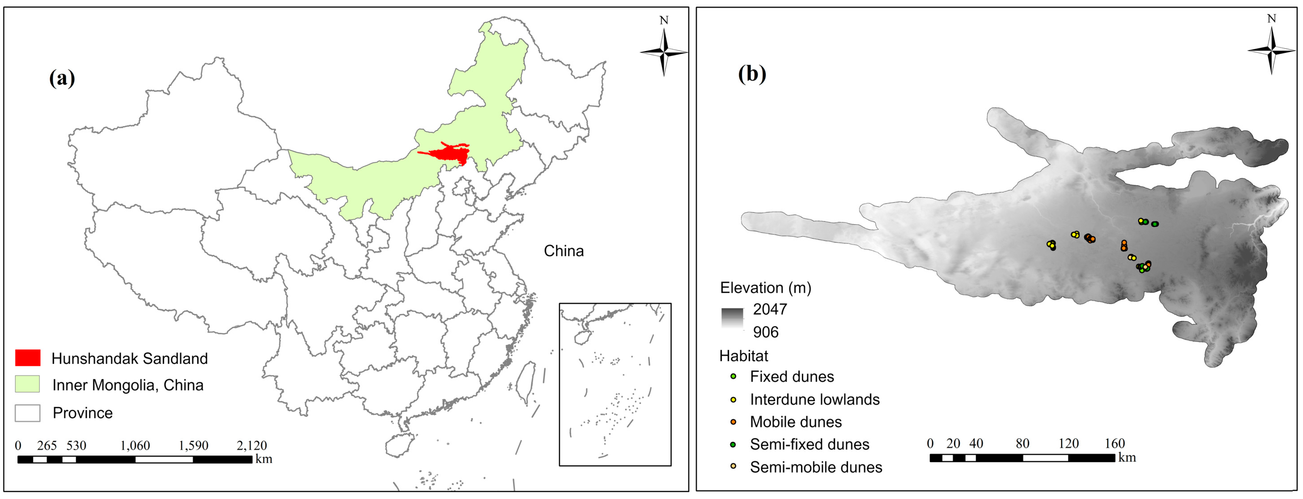
2.1. Study Area
2.2. Field Survey and Sample Plot Selection
2.3. Calculation of the Plant Diversity Index
2.4. Sentinel-2 Imagery and Spectral Index Calculation
2.5. Statistical Analysis
3. Results
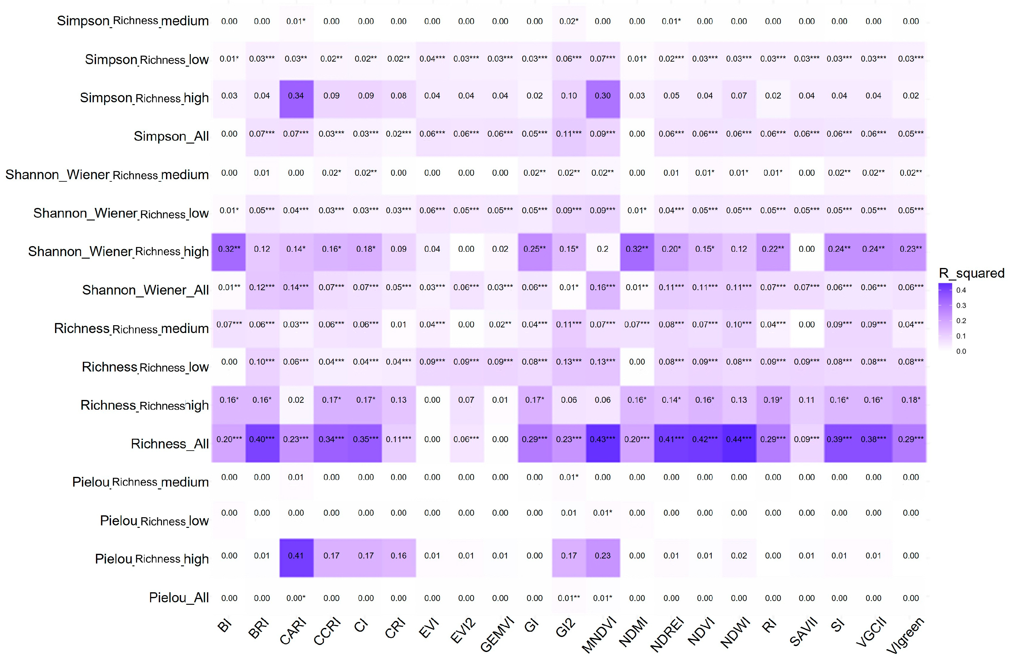
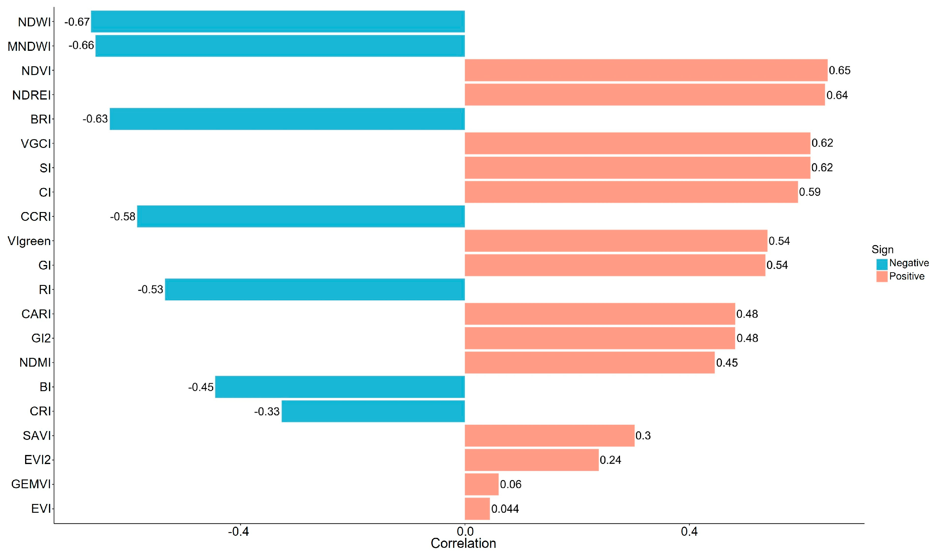
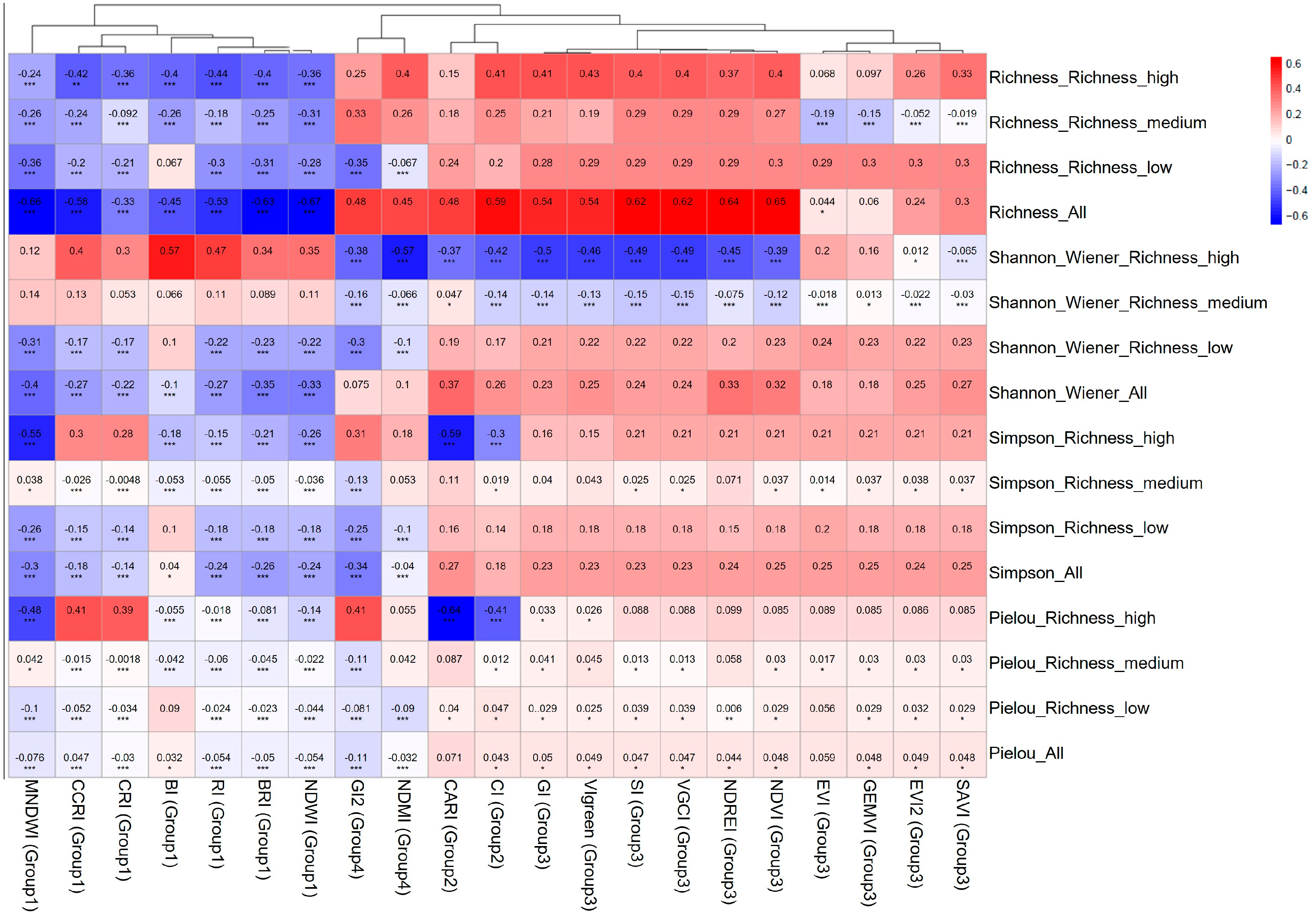
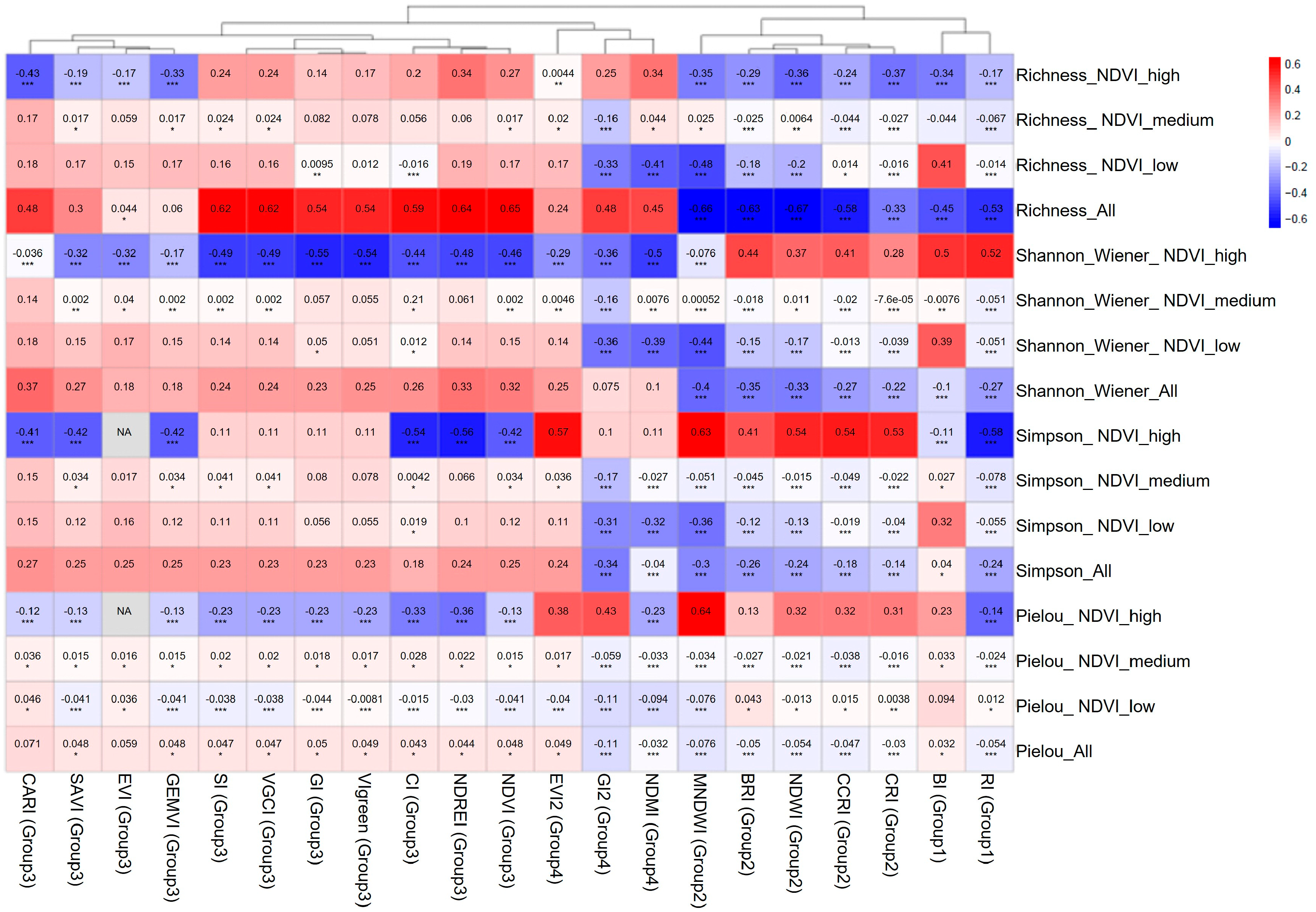
3.1. Relationships Between Spectral Indices and Plant Diversity
3.2. PLSR Model Performance for Different Diversity Indices
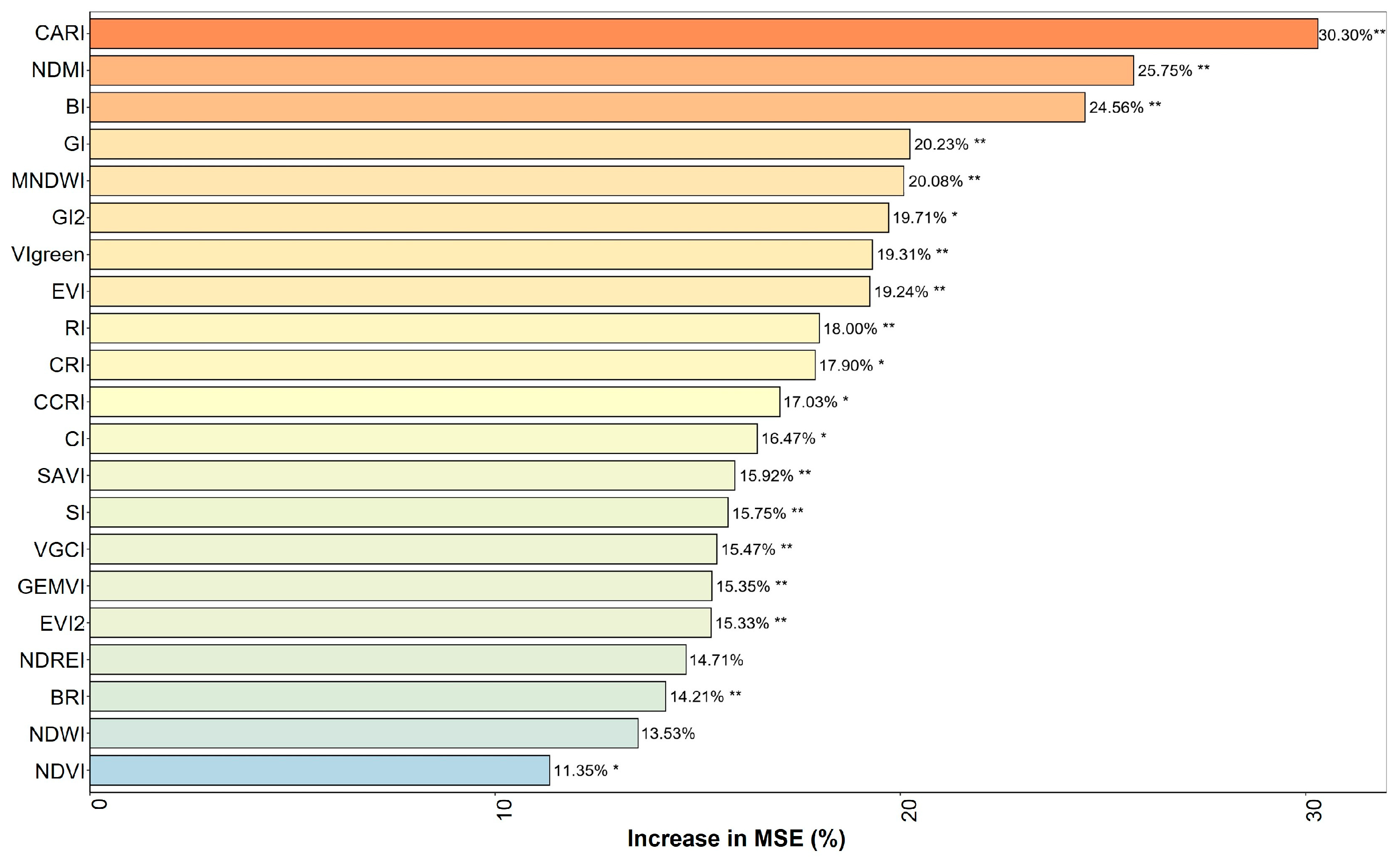
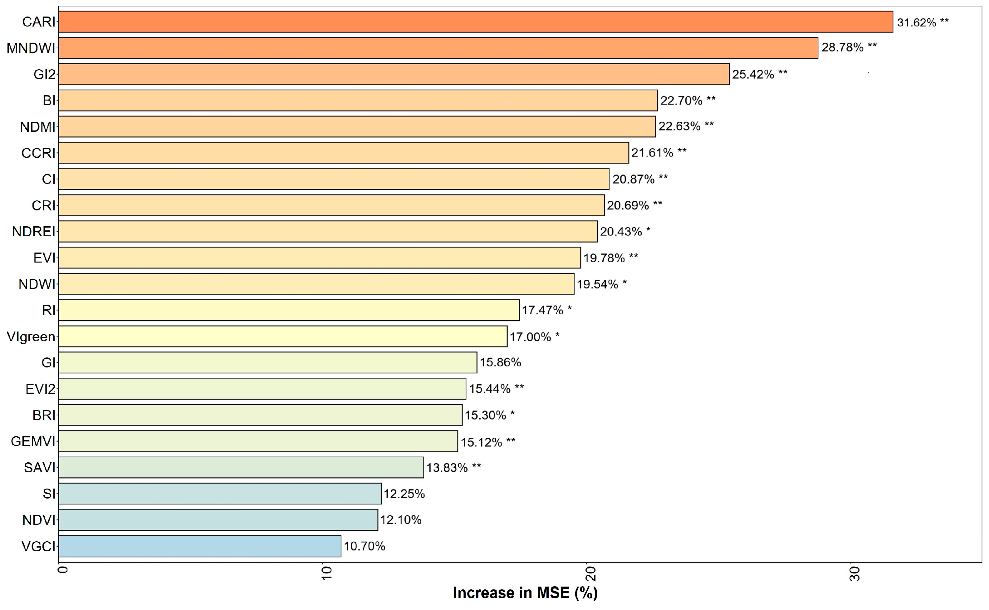
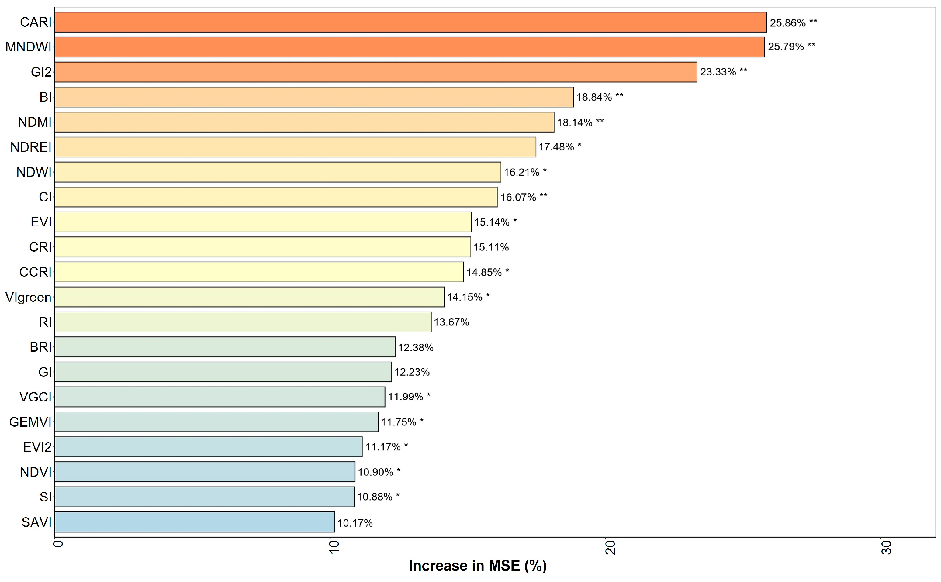
3.3. Importance of Spectral Indices
4. Discussion
4.1. Ecological Interpretation of Spectral–Diversity Relationships in Sandy Ecosystems
4.2. Why Moisture- and Soil-Sensitive Indices Performed Well
4.3. Interpretation of Moderate Model Accuracy
4.4. Comparison with Studies in Arid and Sandy Environments
4.5. Implications for Ecological Monitoring and Restoration
4.6. Limitations and Prospects
5. Conclusions
Author Contributions
Funding
Institutional Review Board Statement
Data Availability Statement
Acknowledgments
Conflicts of Interest
References
- Lande, R. Statistics and partitioning of species diversity, and similarity among multiple communities. Oikos 1996, 76, 5–13. [Google Scholar] [CrossRef]
- Whittaker, R.H. Evolution and measurement of species diversity. TAXON 1972, 21, 213–251. [Google Scholar] [CrossRef]
- Colwell, R.K. Biodiversity: Concepts, Patterns, and Measurement. Princet. Guide Ecol. 2009, 663, 257–263. [Google Scholar]
- Simpson, E.H. Measurement of diversity. Nature 1949, 163, 688. [Google Scholar] [CrossRef]
- Shannon, C.E. A mathematical theory of communication. Bell Syst. Tech. J. 1948, 27, 379–423+623–656. [Google Scholar] [CrossRef]
- Pielou, E.C. The measurement of diversity in different types of biological collections. J. Theor. Biol. 1966, 13, 131–144. [Google Scholar] [CrossRef]
- Phiri, D.; Simwanda, M.; Salekin, S.; Nyirenda, V.R.; Murayama, Y.; Ranagalage, M. Sentinel-2 data for land cover/use mapping: A review. Remote Sens. 2020, 12, 2291. [Google Scholar] [CrossRef]
- Karnieli, A.; Qin, Z.; Wu, B.; Panov, N.; Yan, F. Spatio-temporal dynamics of land-use and land-cover in the Mu Us sandy land, China, using the change vector analysis technique. Remote Sens. 2014, 6, 9316–9339. [Google Scholar] [CrossRef]
- Schimel, D.; Townsend, P.A.; Pavlick, R. Prospects and pitfalls for spectroscopic remote sensing of biodiversity at the global scale. In Remote Sensing of Plant Biodiversity; Springer: Berlin/Heidelberg, Germany, 2020; pp. 503–518. [Google Scholar]
- Kreri, S.; Farhi, N.; Bennia, A.; Derdour, A.; Kébir, L.W.; Alharbi, K.M.; Bojer, A.K.; Arafat, A.A. Remote sensing assessment of vegetation and moisture dynamics in semi-arid regions. Sci. Rep. 2026, 16, 6549. [Google Scholar] [CrossRef] [PubMed]
- Meng, X.; Gao, X.; Li, S.; Lei, J. Spatial and temporal characteristics of vegetation NDVI changes and the driving forces in Mongolia during 1982–2015. Remote Sens. 2020, 12, 603. [Google Scholar] [CrossRef]
- Yang, Q.; Wang, L.; Huang, J.; Lu, L.; Li, Y.; Du, Y.; Ling, F. Mapping plant diversity based on combined SENTINEL-1/2 data—Opportunities for subtropical mountainous forests. Remote Sens. 2022, 14, 492. [Google Scholar] [CrossRef]
- Rocchini, D.; Boyd, D.S.; Féret, J.B.; Foody, G.M.; He, K.S.; Lausch, A.; Nagendra, H.; Wegmann, M.; Pettorelli, N. Satellite remote sensing to monitor species diversity: Potential and pitfalls. Remote Sens. Ecol. Conserv. 2016, 2, 25–36. [Google Scholar] [CrossRef]
- Schneider, F.D.; Morsdorf, F.; Schmid, B.; Petchey, O.L.; Hueni, A.; Schimel, D.S.; Schaepman, M.E. Mapping functional diversity from remotely sensed morphological and physiological forest traits. Nat. Commun. 2017, 8, 1441. [Google Scholar] [CrossRef]
- Zheng, Z.; Zeng, Y.; Schneider, F.D.; Zhao, Y.; Zhao, D.; Schmid, B.; Schaepman, M.E.; Morsdorf, F. Mapping functional diversity using individual tree-based morphological and physiological traits in a subtropical forest. Remote Sens. Environ. 2021, 252, 112170. [Google Scholar] [CrossRef]
- Meng, J.; Li, S.; Wang, W.; Liu, Q.; Xie, S.; Ma, W. Estimation of forest structural diversity using the spectral and textural information derived from SPOT-5 satellite images. Remote Sens. 2016, 8, 125. [Google Scholar] [CrossRef]
- Sesnie, S.E.; Espinosa, C.I.; Jara-Guerrero, A.K.; Tapia-Armijos, M.F. Ensemble machine learning for mapping tree species alpha-diversity using multi-source satellite data in an Ecuadorian seasonally dry forest. Remote Sens. 2023, 15, 583. [Google Scholar] [CrossRef]
- Gholizadeh, H.; Gamon, J.A.; Zygielbaum, A.I.; Wang, R.; Schweiger, A.K.; Cavender-Bares, J. Remote sensing of biodiversity: Soil correction and data dimension reduction methods improve assessment of α-diversity (species Richness) in prairie ecosystems. Remote Sens. Environ. 2018, 206, 240–253. [Google Scholar] [CrossRef]
- Zhao, Y.; Sun, Y.; Chen, W.; Zhao, Y.; Liu, X.; Bai, Y. The potential of mapping grassland plant diversity with the links among spectral diversity, functional trait diversity, and species diversity. Remote Sens. 2021, 13, 3034. [Google Scholar] [CrossRef]
- Tian, Y.; Fu, G. Quantifying plant species α-diversity using normalized difference vegetation index and climate data in alpine grasslands. Remote Sens. 2022, 14, 5007. [Google Scholar] [CrossRef]
- Peng, Y.; Fan, M.; Song, J.; Cui, T.; Li, R. Assessment of plant species diversity based on hyperspectral indices at a fine scale. Sci. Rep. 2018, 8, 4776. [Google Scholar] [CrossRef]
- Drori, R.; Dan, H.; Sprintsin, M.; Sheffer, E. Precipitation-sensitive dynamic threshold: A new and simple method to detect and monitor forest and woody vegetation cover in sub-humid to arid areas. Remote Sens. 2020, 12, 1231. [Google Scholar] [CrossRef]
- Fern, R.R.; Foxley, E.A.; Bruno, A.; Morrison, M.L. Suitability of NDVI and OSAVI as estimators of green biomass and coverage in a semi-arid rangeland. Ecol. Indic. 2018, 94, 16–21. [Google Scholar] [CrossRef]
- Wei, W.; Zhang, H.; Zhou, J.; Zhou, L.; Xie, B.; Li, C. Drought monitoring in arid and semi-arid region based on multi-satellite datasets in northwest, China. Environ. Sci. Pollut. Res. Int. 2021, 28, 51556–51574. [Google Scholar] [CrossRef]
- Schmidtlein, S.; Fassnacht, F.E. The spectral variability hypothesis does not hold across landscapes. Remote Sens. Environ. 2017, 192, 114–125. [Google Scholar] [CrossRef]
- Peña-Lara, V.A.; Dupuy, J.M.; Reyes-Garcia, C.; Sanaphre-Villanueva, L.; Portillo-Quintero, C.A.; Hernández-Stefanoni, J.L. Modelling species Richness and functional diversity in tropical dry forests using multispectral remotely sensed and topographic data. Remote Sens. 2022, 14, 5919. [Google Scholar] [CrossRef]
- Farwell, L.S.; Gudex-Cross, D.; Anise, I.E.; Bosch, M.J.; Olah, A.M.; Radeloff, V.C.; Razenkova, E.; Rogova, N.; Silveira, E.M.; Smith, M.M. Satellite image texture captures vegetation heterogeneity and explains patterns of bird Richness. Remote Sens. Environ. 2021, 253, 112175. [Google Scholar] [CrossRef]
- Cavender-Bares, J.; Gamon, J.A.; Hobbie, S.E.; Madritch, M.D.; Meireles, J.E.; Schweiger, A.K.; Townsend, P.A. Harnessing plant pectra to integrate the biodiversity sciences across biological and spatial scales. Am. J. Bot. 2017, 104, 966–969. [Google Scholar] [CrossRef]
- Lausch, A.; Bannehr, L.; Beckmann, M.; Boehm, C.; Feilhauer, H.; Hacker, J.M.; Heurich, M.; Jung, A.; Klenke, R.; Neumann, C.; et al. Linking Earth Observation and taxonomic, structural and functional biodiversity: Local to ecosystem perspectives. Ecol. Indic. 2016, 70, 317–339. [Google Scholar] [CrossRef]
- Pettorelli, N.; Schulte to Bühne, H.; Tulloch, A.; Dubois, G.; Macinnis-Ng, C.; Queirós, A.M.; Keith, D.A.; Wegmann, M.; Schrodt, F.; Stellmes, M.; et al. Satellite remote sensing of ecosystem functions: Opportunities, challenges and way forward. Remote Sens. Ecol. Conserv. 2018, 4, 71–93. [Google Scholar] [CrossRef]
- Gao, B.-C. NDWI—A normalized difference water index for remote sensing of vegetation liquid water from space. Remote Sens. Environ. 1996, 58, 257–266. [Google Scholar] [CrossRef]
- Wang, R.; Gamon, J.A. Remote sensing of terrestrial plant biodiversity. Remote Sens. Environ. 2019, 231, 111218. [Google Scholar] [CrossRef]
- Fassnacht, F.; Hartig, F.; Latifi, H.; Berger, C.; Hernández, J.; Corvalán, P.; Koch, B. Importance of sample size, data type and prediction method for remote sensing-based estimations of aboveground forest biomass. Remote Sens. Environ. 2014, 154, 102–114. [Google Scholar] [CrossRef]
- Huete, A.; Didan, K.; Miura, T.; Rodriguez, E.P.; Gao, X.; Ferreira, L.G. Overview of the radiometric and biophysical performance of the MODIS vegetation indices. Remote Sens. Environ. 2002, 83, 195–213. [Google Scholar] [CrossRef]
- Rahmanian, S.; Nasiri, V.; Amindin, A.; Karami, S.; Maleki, S.; Pouyan, S.; Borz, S.A. Prediction of plant diversity using multi-seasonal remotely sensed and geodiversity data in a mountainous area. Remote Sens. 2023, 15, 387. [Google Scholar] [CrossRef]
- Qi, Y. Random forest for bioinformatics. In Ensemble Machine Learning: Methods and Applications; Rokach, L., Maimon, O., Eds.; Springer: Berlin/Heidelberg, Germany, 2012; pp. 307–323. [Google Scholar]
- Wang, B.; Chen, Y.; Yan, Z.; Liu, W. Integrating remote sensing data and CNN-LSTM-Attention Techniques for improved forest stock volume Estimation: A Comprehensive analysis of Baishanzu Forest Park, China. Remote Sens. 2024, 16, 324. [Google Scholar] [CrossRef]

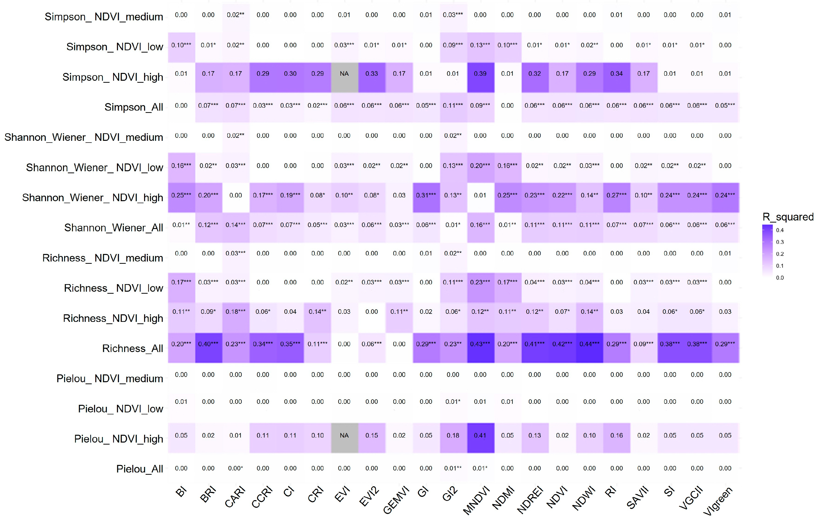


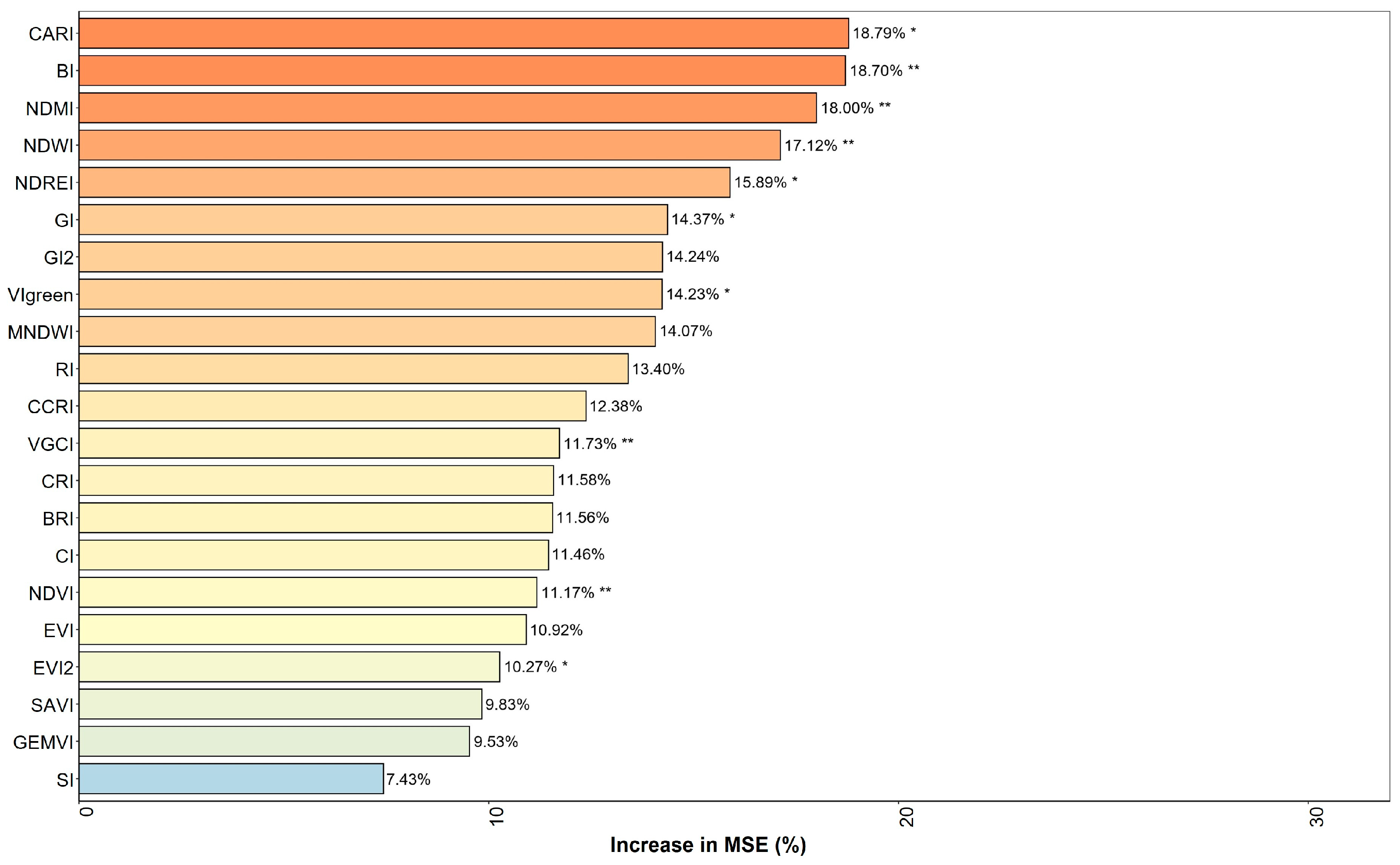

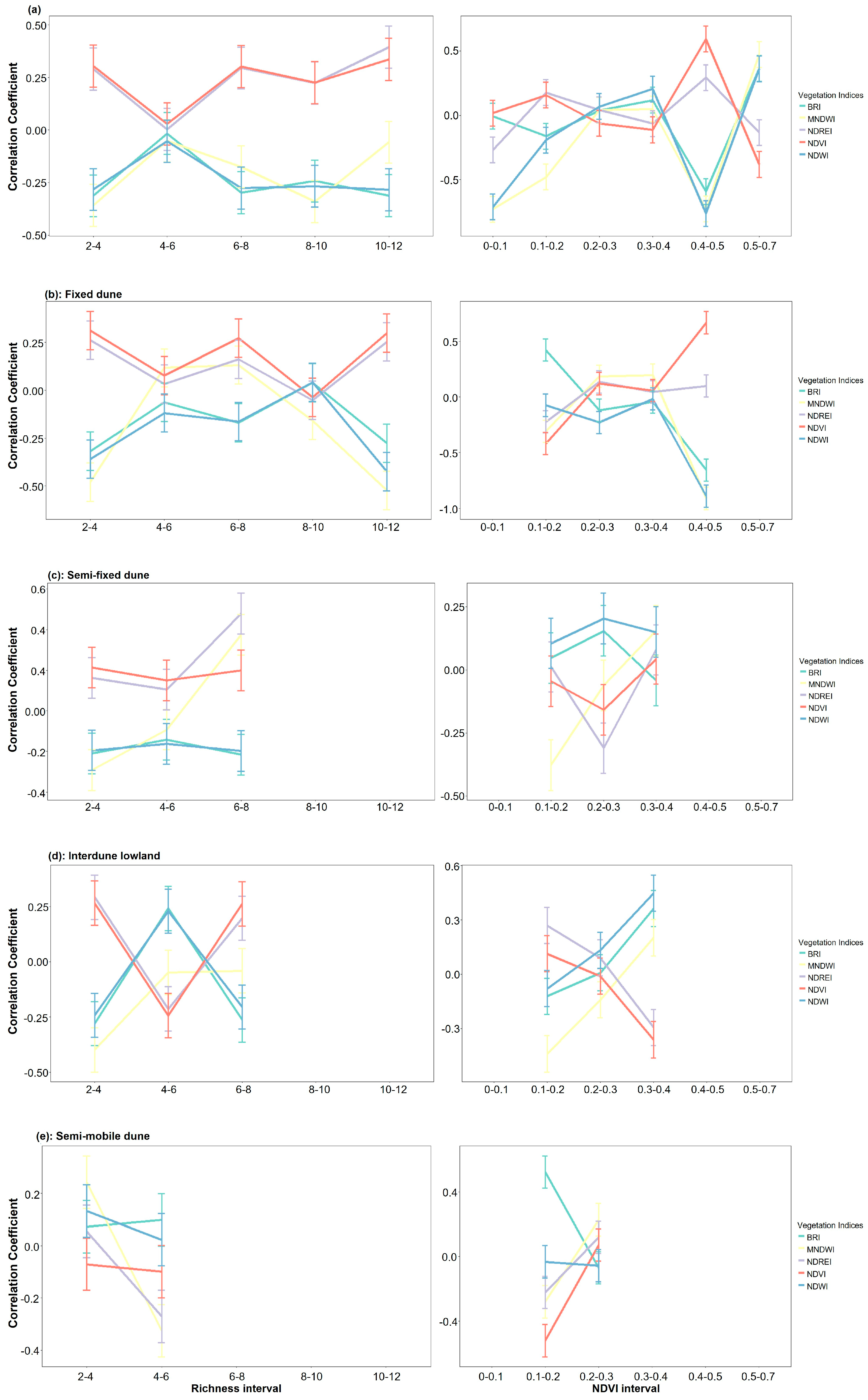

| Number | Index | Formula |
|---|---|---|
| 1 | NDVI | (B8 − B4)/(B8 + B4) |
| 2 | BI | (B11 − B8)/(B11 + B8) |
| 3 | BRI | B4/B8 |
| 4 | CI | (B5 − B4)/(B5 + B4) |
| 5 | CARI | B4 + (2 × (B5 − B4) × (B3 − B4)) |
| 6 | CCRI | B4/B5 |
| 7 | VIgreen | (B3 − B4)/(B3 + B4) |
| 8 | CRI | (B5 + B4)/(B5 − B4) |
| 9 | EVI2 | 2.5 × (B8 − B4)/(B8 + 2.4 × B4 + 1) |
| 10 | EVI | 2.5 × (B8A − B4)/(B8A + 6 × B4 − 7.5 × B2 + 1) |
| 11 | GEMVI | (B8 − B4)/(B8 + B4 + 1) |
| 12 | GI2 | (B3 − B2)/(B3 + B2) |
| 13 | GI | B3/B4 |
| 14 | MNDWI | (B3 − B11)/(B3 + B11) |
| 15 | NDMI | (B8 − B11)/(B8 + B11) |
| 16 | NDREI | (B8 − B5)/(B8 + B5) |
| 17 | NDWI | (B3 − B8)/(B3 + B8) |
| 18 | RI | B4/B3 |
| 19 | SAVI | (B8 − B4)/(B8 + B4 + L) × (1 + L) |
| 20 | SI | B8/B4 |
| 21 | VGCI | (B8 − B4)/B4 |
Disclaimer/Publisher’s Note: The statements, opinions and data contained in all publications are solely those of the individual author(s) and contributor(s) and not of MDPI and/or the editor(s). MDPI and/or the editor(s) disclaim responsibility for any injury to people or property resulting from any ideas, methods, instructions or products referred to in the content. |
© 2026 by the authors. Licensee MDPI, Basel, Switzerland. This article is an open access article distributed under the terms and conditions of the Creative Commons Attribution (CC BY) license.
Share and Cite
Xiang, K.; Liu, Z.; Chen, X.; Peng, Y. Remote Sensing Estimation of Plant Diversity in Sandy Ecosystem Based on Sentinel-2 Data. Diversity 2026, 18, 295. https://doi.org/10.3390/d18050295
Xiang K, Liu Z, Chen X, Peng Y. Remote Sensing Estimation of Plant Diversity in Sandy Ecosystem Based on Sentinel-2 Data. Diversity. 2026; 18(5):295. https://doi.org/10.3390/d18050295
Chicago/Turabian StyleXiang, Kairu, Zhiqiang Liu, Xinyan Chen, and Yu Peng. 2026. "Remote Sensing Estimation of Plant Diversity in Sandy Ecosystem Based on Sentinel-2 Data" Diversity 18, no. 5: 295. https://doi.org/10.3390/d18050295
APA StyleXiang, K., Liu, Z., Chen, X., & Peng, Y. (2026). Remote Sensing Estimation of Plant Diversity in Sandy Ecosystem Based on Sentinel-2 Data. Diversity, 18(5), 295. https://doi.org/10.3390/d18050295