Article

A Floristic Analysis of Vascular Plants by the Disturbance Type and Application of Ecological Restoration Strategies in the Baekdudaegan Protected Area of South Korea

by
Young-Soo Kim
,
Gyu-Il Han
,
Seong-Bin Kim
,
Min-Woo Lee
,
Se-Kyu Song
,
Sang-Geun Kim
and
Tae-Im Heo
*
Ecological Forest Restoration Office, Baekdudaegan National Arboretum, 2160-53 Munsu-ro, Chunyang-Myeon, Bonghwa-gun 36209, Republic of Korea
*
Author to whom correspondence should be addressed.
Diversity 2025, 17(6), 378; https://doi.org/10.3390/d17060378
Submission received: 27 March 2025 / Revised: 17 May 2025 / Accepted: 19 May 2025 / Published: 27 May 2025

Abstract

:
This study evaluated the floristic characteristics and ecological conditions of disturbed sites within the Baekdudaegan Protected Area by analyzing species occurrence and ecological indices according to the region and disturbance type. A total of 515 vascular plant species were recorded, including rare species, alien species, and Korean endemic plants. To assess ecological patterns, the Naturalization Index (NI), Urbanization Index (UI), and Sørensen similarity index were applied. The results showed that Mt. Seoraksan, Mt. Deogyusan, and Mt. Taebaeksan had relatively high NI and UI values, while Mt. Jirisan showed a comparatively low UI value. Among disturbance types, the hiking trail (HT) type, located in a high-altitude area with limited accessibility, also recorded lower values. Floristic similarity with reference ecosystems was higher in Mt. Jirisan, Mt. Deogyusan, and Mt. Taebaeksan, whereas Mt. Seoraksan exhibited the lowest similarity. The overall similarity between disturbance types was low, and the composition of plant species varied across disturbance types. These results suggest that differences in disturbance intensity, driven by the disturbance type and topographic conditions, influences the floristic composition. The findings of this study can serve as baseline data for developing site-specific restoration strategies for disturbed sites in the future.

1. Introduction

Mountain ecosystems around the world play a crucial role in conserving biodiversity by providing habitats for plant species and connecting fragmented landscapes. The Baekdudaegan mountain range, which extends approximately 1600 km from Mt. Baekdusan in the north to Mt. Jirisan in the south, serves as a major ecological corridor on the Korean Peninsula [1]. Often referred to as the “spine of the Korean Peninsula”, this mountainous system holds high ecological and conservation value due to its high elevation, rugged terrain, and relatively well-preserved natural environment [2,3]. Like other prominent mountain systems such as the Alps, the Rockies, and the Himalayas, Baekdudaegan has functioned as a refuge for plant species during past climate changes, playing a key role in maintaining biodiversity at both the regional and global levels [4,5,6,7].
To protect this ecologically significant region, the Korean government designated the Baekdudaegan Protected Area in 2005 under the Baekdudaegan Protection Act. Despite this legal protection, many areas within Baekdudaegan remain degraded or disturbed [8]. Past activities such as deforestation, road construction, and quarrying have caused habitat loss and fragmentation, leading to disruptions in ecosystem function [9,10]. Similar environmental challenges are observed globally, as mountain forests face increasing threats from land-use change, urban expansion, and climate change [11,12,13]. While previous studies have examined vegetation structure [3,14,15,16], the condition of disturbed sites [8,17,18], restoration and monitoring efforts [19,20,21,22,23,24], and the flora of vascular plants in specific areas of Baekdudaegan [1,10,25,26,27,28,29,30], there remains a lack of comprehensive research on how vascular plant diversity varies across different types of disturbed sites in this region. Addressing this research gap is essential not only for conservation efforts within Korea but also for developing ecological restoration strategies applicable to mountain ecosystems worldwide.
Disturbed forest sites commonly undergo secondary succession, during which pioneer species establish themselves and gradually alter species composition over time [31]. These changes can have long-term impacts on the structure and function of forest ecosystems. Effective ecological restoration requires a detailed assessment of current plant diversity in disturbed sites and comparison with relatively undisturbed reference ecosystems, which serve as models for setting restoration targets by offering insights into pre-disturbance species composition and structure [32,33]. Moreover, analyzing species composition across various types of disturbed sites can help elucidate how disturbance intensity influences species occurrence and patterns of ecosystem recovery.
Accordingly, this study investigates how vascular plant diversity and composition differ among various types of disturbed sites within the Baekdudaegan Protected Area and compares these patterns with those observed in nearby reference ecosystems. By applying ecological indices such as the Naturalization Index, Urbanization Index, and Sørensen similarity coefficient, the study seeks to clarify whether current vegetation patterns reflect natural successional recovery or indicate the need for active restoration interventions, including the removal of alien species or habitat enrichment. Specifically, this study aims to (1) analyze vascular plant diversity and species composition across different types of disturbed sites, (2) compare the floristic similarity between disturbed sites and reference ecosystems, and (3) provide scientific insights to support the development of site-specific restoration strategies based on disturbance type and intensity.
Furthermore, the results of this study offer foundational data with wide-ranging applicability, including the development of restoration strategies by disturbance type, ecological indicator-based monitoring systems, and the prioritization of restoration efforts.

2. Materials and Methods

2.1. Study Area and Site Selection

This study was conducted within the Baekdudaegan Protected Area, designated by the Korean Forest Service in the Second Baekdudaegan Protection Plan (2016–2025) [34]. The study area was divided into five regions: Mt. Jirisan, Mt. Deogyusan, Mt. Songnisan, Mt. Taebaeksan, and Mt. Seoraksan. From 2019 to 2023, disturbed sites were selected annually within each region based on high-resolution aerial imagery (25 cm resolution) provided by the National Geographic Information Institute of Korea, which is updated every two years. In cases where dense forest cover or rugged terrain made it difficult to accurately identify disturbed sites, past aerial images from various domestic platforms were cross-checked to supplement site selection (Figure 1).
The classification of disturbance types was based on field observations and aerial image analysis. These included arable lands, bare lands/grasslands, cutover/restoration area, roads/forest roads, burial grounds, constructions, abandoned quarries, farms, and hiking trails. The number of disturbed sites in each category across the study regions is summarized (Table 1), and the total distribution of disturbance types is presented as a pie chart (Figure 2).

2.2. Field Surveys and Plant Identification

A total of 155 disturbed sites were identified through aerial image analysis. These sites were categorized as arable lands (45 sites), bare lands/grasslands (37 sites), cutover/restoration areas (23 sites), roads/forest roads (19 sites), burial grounds (11 sites), construction sites (7 sites), abandoned quarries (6 sites), farms (4 sites), and hiking trails (3 sites) (Table A1). In this study, the “bare land/grassland” (BL/GL) category was defined as open areas lacking tree and shrub vegetation where the origin of disturbance was not clearly identifiable. These sites were predominantly abandoned agricultural fields, such as former paddies or dry fields, that had been left unmanaged over time. In the ecological context of Korea, shrubland is not recognized as a distinct vegetation type. Therefore, herbaceous-dominated open sites were grouped into this combined category to reflect the typical vegetation structure of post-agricultural or unmanaged lands frequently observed in Korea. Cutover/restoration areas in this study refer to sites where reforestation was conducted primarily for landscape or soil stabilization purposes using species not native to the original vegetation. These areas were not considered ecologically restored and were thus classified as disturbed sites based on their altered plant composition and lack of natural regeneration.
By region, the sites were distributed as follows: Mt. Jirisan (20 sites), Mt. Deogyusan (34 sites), Mt. Songnisan (30 sites), Mt. Taebaeksan (45 sites), and Mt. Seoraksan (26 sites). Field surveys were conducted from July 2019 to August 2024, and vascular plant species composition was recorded at each site. To establish a baseline for ecological restoration, reference ecosystems were selected, and plant species surveys were conducted in these areas using the same methods.
Reference ecosystems refer to healthy forest areas that are relatively undisturbed and where natural conditions are well preserved. These areas were selected within each mountain region based on the presence of stable native plant communities and a very low proportion of alien species. Plant identification was primarily conducted in the field. For vascular plants that could not be identified on-site, images were taken, and samples were collected for further examination in the laboratory. The identification of vascular plants followed Coloured Flora of Korea [35] (p. 914) and [35] (p. 901) as a primary reference. To ensure more precise plant identification, additional references were utilized for each major plant family [36,37,38]. The scientific nomenclature, classification system, and taxonomic arrangement followed Plants of the World Online (POWO) [39]. Cultivated plants were marked with “(c)” next to their common names to distinguish them from native flora. Based on the compiled plant list, endemic plants of the Korean peninsula, red-list plants, alien plants, and invasive plants were identified [40,41,42,43,44,45].

2.3. Data Analysis and Index Calculations

To quantitatively assess plant composition, ecological impact, and site similarity, a set of indices was used. These indices were categorized into three groups: (A) Disturbance and Human Impact Indices, (B) Species Diversity and Evenness Indices, and (C) Site Similarity Indices.
(A)
Disturbance and Human Impact Indices.
To evaluate the level of anthropogenic influence on disturbed sites, the following indices were calculated:
Naturalized Index (NI) [46]:
N I = N u m b e r   o f   a l i e n   p l a n t   s p e c i e s   i n   t h e   s t u d y   a r e a T o t a l   n u m b e r   o f   v a s c u l a r   p l a n t   s p e c i e s   i n   t h e   s t u d y   a r e a × 100
This index provides insight into the proportion of non-native species relative to the total plant community, helping to assess the degree of ecosystem disturbance.
Urbanization Index (UI) [47]:
U I = N u m b e r   o f   a l i e n   p l a n t   s p e c i e s   i n   t h e   s t u d y   a r e a T o t a l   n u m b e r   o f   a l i e n   p l a n t   s p e c i e s   i n   K o r e a × 100
This index measures the extent to which urbanization influences plant composition in disturbed sites.
(B)
Site Similarity Analysis.
To compare the species composition between disturbed sites and reference ecosystems, Sørensen’s similarity index was applied:
Sørensen’s Similarity Index (Cs) [48]:
C s = 2 C A + B
where A and B represent the total species in two sites and C is the number of shared species. This index provides insight into the level of similarity between disturbed sites and intact reference ecosystems, aiding in evaluating restoration potential.
(C)
Multivariate Analysis.
To further explore variations in species composition across disturbed sites, non-metric multidimensional scaling (NMDS) and similarity percentage analysis (SIMPER) were performed using the vegan package (v2.6-10) in R (v4.5.0). Bray–Curtis dissimilarity matrices were calculated using the vegdist function, and NMDS was conducted via the metaMDS function with two dimensions and default parameters. The SIMPER analysis was carried out using the simper function to assess the contribution of individual species to group differences.
Non-metric Multidimensional Scaling (NMDS) [49]:
NMDS was conducted using the Bray–Curtis dissimilarity index, which quantifies differences in species occurrence frequency between sites. The ordination was optimized by minimizing the stress function S, defined as follows:
S = ( d i j d ^ i j ) 2 d i j 2
S = S t r e s s   v a l u e   ( l o w e r   v a l u e s   i n d i c a t e   a   b e t t e r   f i t ) .
d i j = O b s e r v e d   d i s t a n c e   b e t w e e n   s a m p l e   i   a n d   j .
d ^ i j = P r e d i c t e d   d i s t a n c e   i n   t h e   r e d u c e d   d i m e n s i o n a l   s p a c e .
A   s t r e s s   v a l u e   b e l o w   0.2   w a s   c o n s i d e r e d   a n   a c c e p t a b l e   m o d e l   f i t .
Similarity Percentage Analysis (SIMPER) [50]:
SIMPER analysis was used to determine the species contributing most to the compositional dissimilarity between disturbed sites and reference ecosystems. The contribution of each species k was calculated as follows:
C K = i = 1 n x ¯ k i x ¯ k j i = 1 n D i j
C k = C o n t r i b u t i o n   o f   s p e c i e s   K   t o   g r o u p   d i f f e r e n c e s .
x ¯ k i = M e a n   a b u n d a n c e   o f   s p e c i e s   k   i n   g r o u p   i .
d ¯ k j = M e a n   a b u n d a n c e   o f   s p e c i e s   k   i n   g r o u p   j .
D i j = M e a n   B r a y C u r t i s   d i s s i m i l a r i t y   b e t w e e n   g r o u p s   i   a n d   j .
These indices and analyses collectively provide a comprehensive assessment of plant composition, anthropogenic disturbance, biodiversity balance, and ecosystem similarity across different types of disturbed sites. The results were analyzed to identify patterns in plant composition and evaluate the ecological conditions of disturbed sites within the Baekdudaegan Protected Area.

3. Results

3.1. Vegetation Characteristics of Disturbed Sites

3.1.1. Floristic Composition of Disturbed Sites

A total of 515 taxa were identified in disturbed sites within the Baekdudaegan Protected Area (Table 2). These taxa included 95 families, 306 genera, 468 species, 18 subspecies, 35 varieties, 2 forms, and 2 hybrids. Pteridophytes comprised 14 taxa (2.7%), gymnosperms 7 taxa (1.3%), dicotyledons 394 taxa (75%), and monocotyledons 110 taxa (21%).
The most dominant families were Asteraceae (67 taxa, 13%), Poaceae (52 taxa, 10.1%), Rosaceae (33 taxa, 6.4%), Fabaceae (32 taxa, 6.2%), and Liliaceae (22 taxa, 4.3%). Among individual species, Artemisia indica Willd. was the most frequently observed, occurring at 118 survey plots, followed by Erigeron annuus (L.) Desf. (106 plots), Rubus crataegifolius Bunge (77 plots), Erigeron canadensis L. (65 plots), and Plantago asiatica L. (60 plots). In contrast, 198 taxa, including Aristolochia manshuriensis Kom., Aquilegia oxysepala Trautv. & C.A.Mey., and Veratrum maackii var. parviflorum (Maxim. ex Miq.) H.Hara, were recorded at only a single survey plot (Table S1).
A comparative analysis of species composition across different types of disturbed sites revealed that heavily disturbed sites were primarily dominated by pioneer species, whereas relatively undisturbed sites exhibited greater species diversity. Notably, in zones with minimal anthropogenic interference, herbaceous plants were more evenly distributed, reflecting higher ecological stability.

3.1.2. Endemic Plant Species in Disturbed Sites

A total of 12 Korean endemic plant species were identified (Table 3). While some species were widely distributed across diverse environments, others were restricted to specific habitats. Populus × tomentiglandulosa T.B.Lee, Anemone koraiensis Nakai, Weigela subsessilis (Nakai) L.H.Bailey, etc., were found at multiple survey plots, indicating relatively broad distribution ranges. In contrast, Clematis heracleifolia DC., Angelica genuflexa Nutt., and Patrinia saniculifolia Hemsl. were recorded at only a single plot, highlighting their highly localized occurrence.
The occurrence of endemic species varied according to disturbance type. Their frequency was higher in the cutover/restoration area, whereas their presence was less common in the construction and farm area. Additionally, some endemic species were identified in locations adjacent to intact forest ecosystems, suggesting ecological connectivity with surrounding habitats.

3.1.3. Rare Plant Species in Disturbed Sites

Four rare plant species were identified (Table 4): Bupleurum euphorbioides Nakai, Rhododendron micranthum Turcz., Lysimachia pentapetala Bunge, and Erythranthe tenellus (Bunge) G.L.Nesom. These species were characterized by small population sizes and highly restricted habitat ranges.
Among them, R. micranthum was recorded at multiple sites and appeared to tolerate a range of environmental conditions. In contrast, B. euphorbioides, L. pentapetala, and E. tenellus were found at only a single location, indicating their extreme habitat specificity.

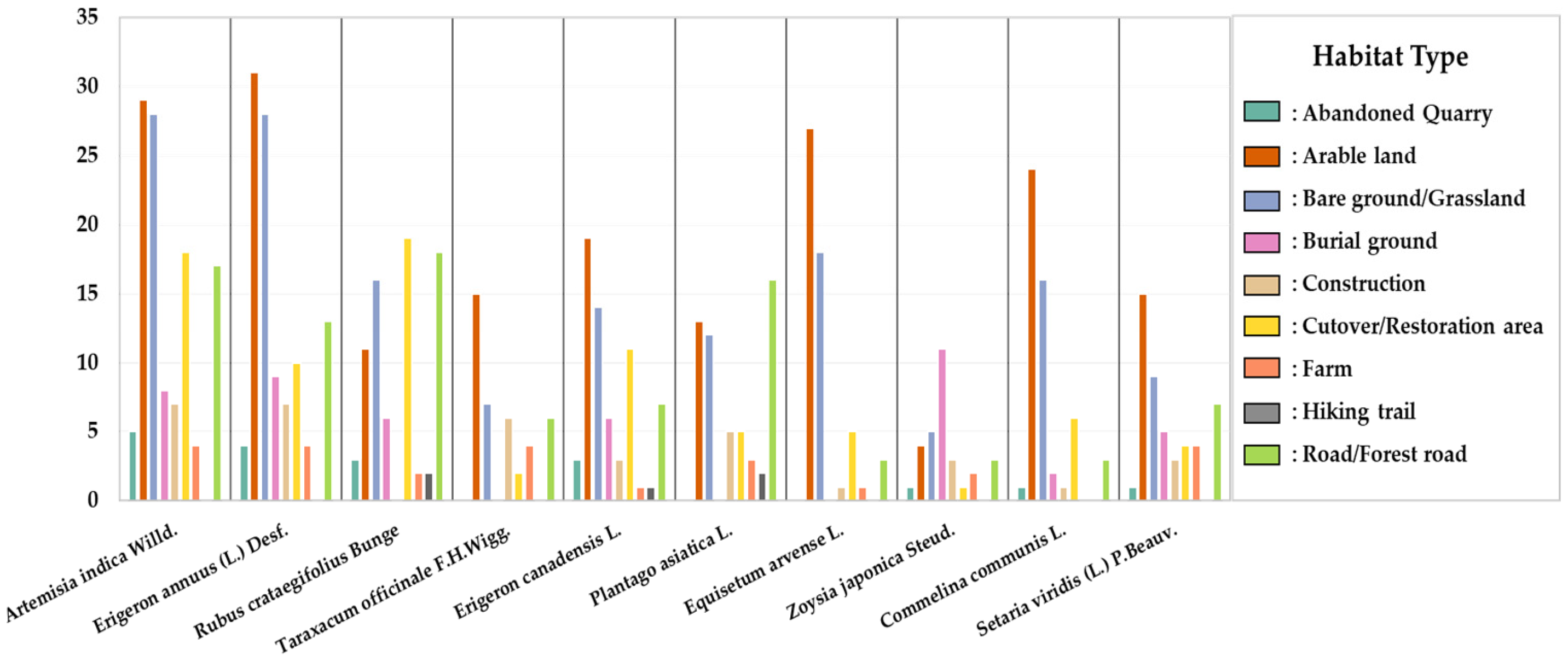
3.1.4. Alien Plant and Invasive Plant Species in Disturbed Sites

A total of 43 alien plant species were identified (Table A2). The most dominant families among these were Asteraceae (15 taxa, 34.9%), Fabaceae (6 taxa, 14.0%), and Poaceae (6 taxa, 14.0%).
Notably, Ambrosia artemisiifolia L., Erigeron canadensis L., and Solidago gigantean Aiton were frequently observed in disturbed sites, where they tended to dominate open habitats. These species demonstrated strong competitive abilities, contributing to the alteration of native plant communities in affected regions.

3.2. Comparative Analysis of Naturalization Index (NI), Urbanization Index (UI), and Species Similarity of Disturbed Sites by Region and Disturbance Type

3.2.1. Comparison of NI and UI Between Disturbed Sites and Reference Ecosystems

The Naturalization Index (NI) and Urbanization Index (UI) were compared across regions (Figure 3). NI was highest in Mt. Seoraksan (11.9%), followed by Mt. Deogyusan (9.0%), Mt. Taebaeksan (8.6%), Mt. Jirisan (8.3%), and Mt. Songnisan (7.5%). UI was highest in Mt. Deogyusan and Mt. Taebaeksan, both at 5.4%, followed by Mt. Seoraksan (4.5%), Mt. Songnisan (4.2%), and Mt. Jirisan (3.2%). While Mt. Seoraksan had the highest NI (11.9%), its UI was lower than that of Mt. Deogyusan and Mt. Taebaeksan. Mt. Jirisan recorded the lowest values for both indices, with an NI of 8.3% and a UI of 3.2%.
By disturbance type, the highest NI was observed in FAs (30.4%), followed by CS (20.3%), BLs/GLs (11.9%), ALs (11.0%), CO/RAs (9.1%), and ROs/FRs (8.1%). For UI, the highest values were found in ALs (7.1%), BLs/GLs (7.0%), and CO/RAs (6.3%), followed by ROs/FRs (4.0%), CS (3.4%), FAs (2.9%), BGs (2.1%), and HTs (0.6%). HTs showed the lowest values in both indices, with an NI of 5.0% and a UI of 0.6%.
The HT type showed clearly lower values in both indices compared to other types, which may be related to its location at elevations above 900 m, where the establishment of non-native plant species is likely to be more limited. The NI was relatively high in FA and CS types, while the UI was comparatively higher in ALs, BLs/GLs, and CO/RAs. These results indicate that the variation in the NI and UI is influenced by the disturbance type and topographic conditions and that the distribution of naturalized and urban-adapted species may differ depending on spatial environmental factors.

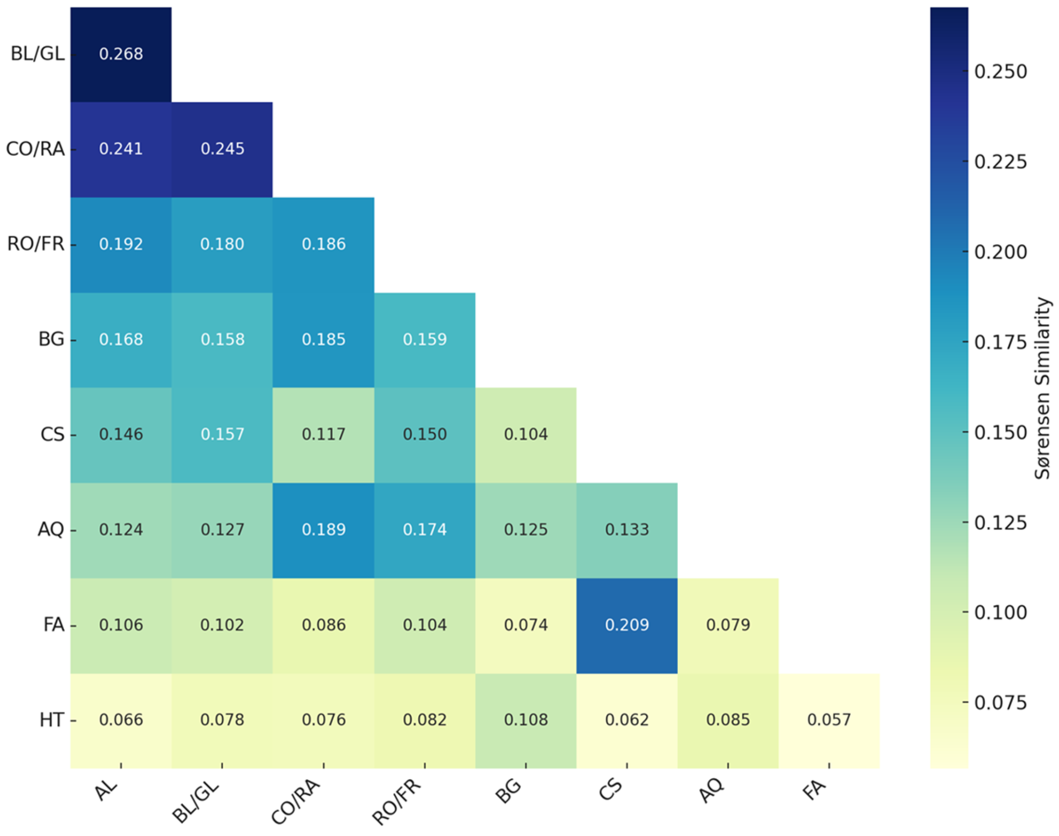
3.2.2. Comparison of Sørensen Similarity Index Between Disturbed Sites and Reference Ecosystems by Region and Disturbance Type

The Sørensen similarity index was calculated to compare the composition of plant species between disturbed sites and reference ecosystems in each region. The highest similarity was observed in Mt. Jirisan (0.509), while Mt. Seoraksan exhibited the lowest value (0.322) (Figure 4). These values indicate the degree of overlap in species occurrence between disturbed sites and reference ecosystems and reveal clear differences in similarity among the five regions. In particular, the regions with similarity values exceeding 0.5 suggest relatively higher levels of species-level resemblance, whereas the lower value in Mt. Seoraksan reflects comparatively limited species overlap. These results provide a standardized basis for comparing interregional variation in floristic similarity using a consistent metric.
The Sørensen similarity index was also used to evaluate the floristic similarity between different disturbance types based on species occurrence data. Most similarity values ranged from the 0.1 s to the low 0.2 s. The highest similarity was observed between the BL/GL and CO/RA types (0.268), followed by CO/RAs–ROs/FRs (0.186), CO/RAs–BGs (0.185), and ROs/FRs–BGs (0.159). Lower similarity values were found in combinations such as BLs/GLs–BGs (0.158), BLs/GLs–ROs/FRs (0.180), and ROs/FRs–CS (0.148) (Figure 5). The generally low values across most combinations indicate considerable variation in species composition among disturbance types. The CO/RA type showed relatively higher similarity with multiple other types, whereas the BL/GL type showed variability in similarity depending on the pairing. These findings quantitatively reflect the differences in plant species composition that result from varying disturbance causes and environmental conditions.

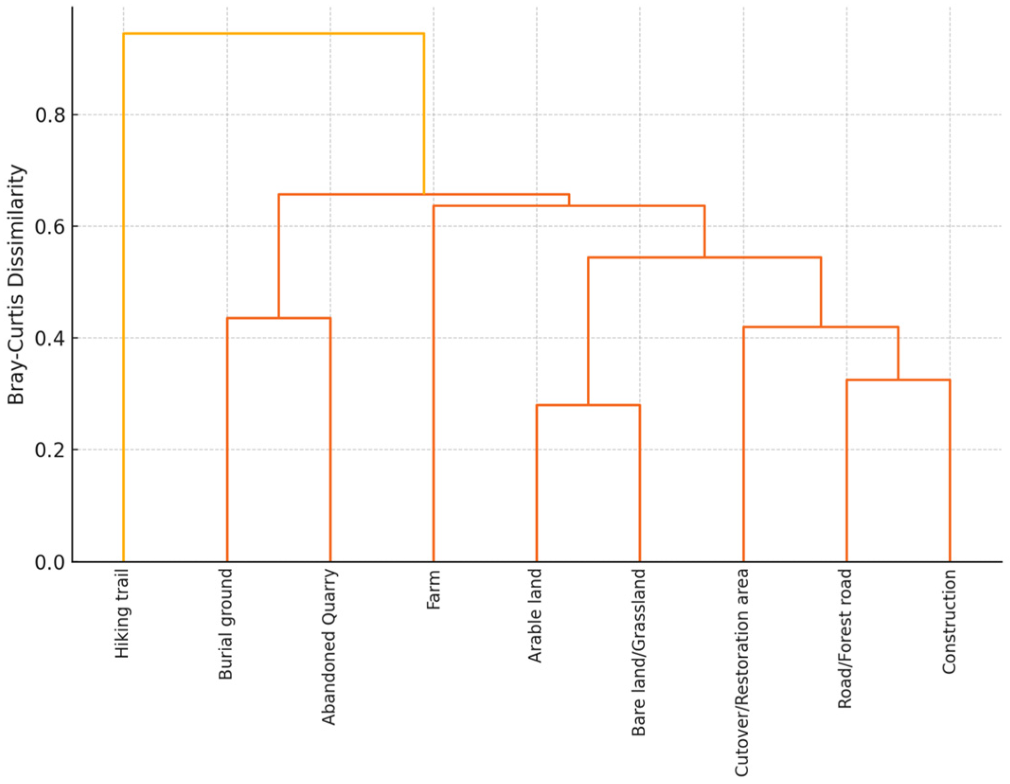
3.3. Analysis Using Non-Metric Multidimensional Scaling (NMDS)

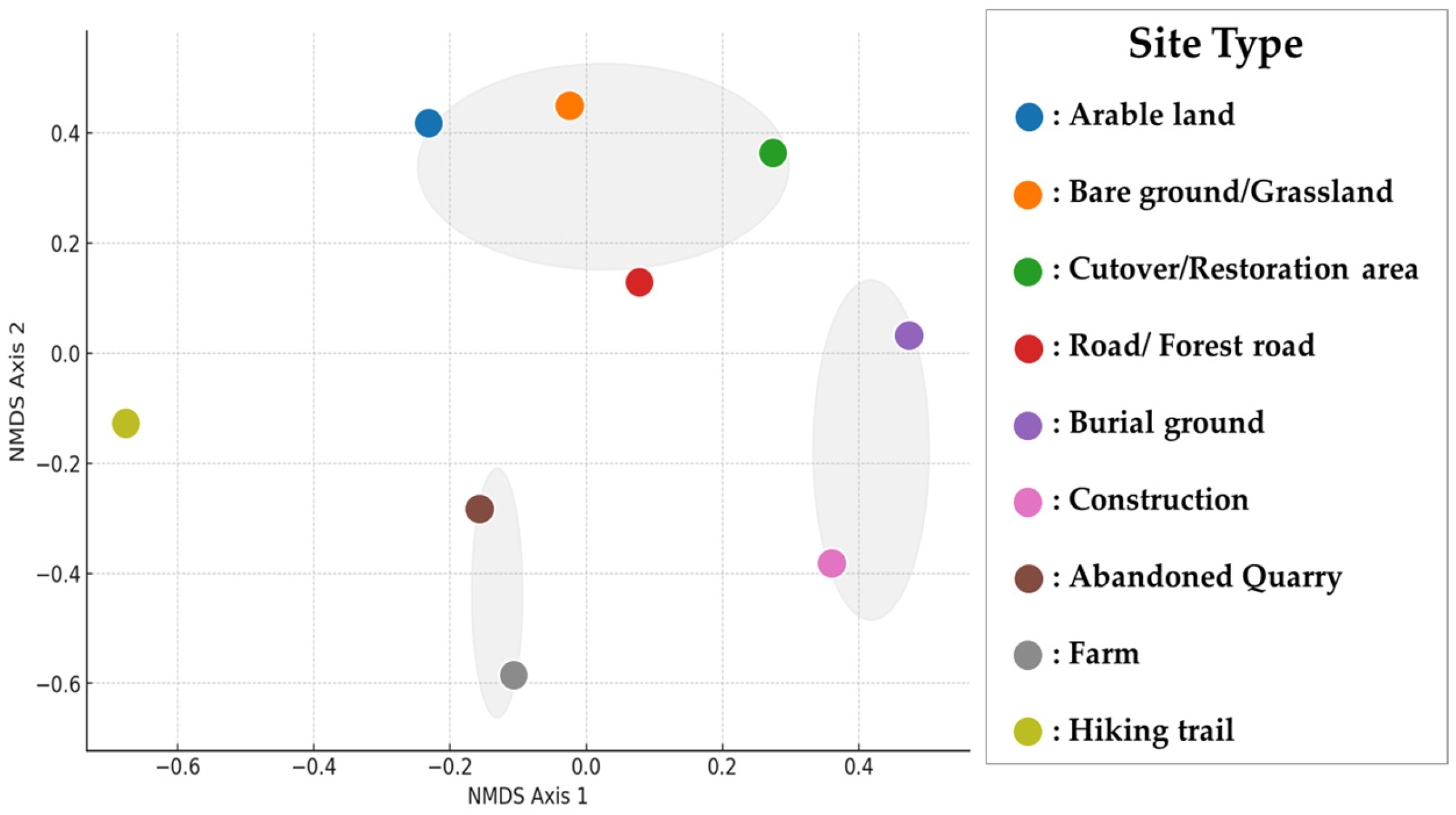
3.3.1. Analysis of Total Flora by Disturbed Site Type (NMDS and Cluster Analysis)

To compare the total floristic composition across different disturbed site types, non-metric multidimensional scaling (NMDS) and hierarchical cluster analysis based on Bray–Curtis distances were conducted. The results revealed distinct patterns in floristic composition depending on the type of disturbance, with some site types exhibiting high similarities (Figure 6). NMDS analysis indicated that arable land, bare land/grassland, and cutover/restoration areas formed relatively close clusters, reflecting similar floristic trends among these types. In contrast, roads/forest roads, abandoned quarries, construction sites, and hiking trails were more dispersed, indicating distinct differences in floristic composition.
Notably, abandoned quarries and construction sites were positioned at a considerable distance from other types along the NMDS axes, highlighting their unique plant compositions. Similarly, hiking trails were distinctly separated, suggesting that their flora exhibits independent characteristics rather than aligning closely with other site types.
Additionally, a hierarchical cluster analysis based on Bray–Curtis distances was performed to compare floristic composition at the community level, revealing distinct major groups by type (Figure 7). The cluster analysis showed that arable land, bare land/grassland, and cutover/restoration areas clustered together at the shortest distances, indicating high floristic similarity among these types. In contrast, hiking trails, abandoned quarries, and construction sites formed distinct clusters, reflecting independent floristic compositions. Particularly, hiking trails formed the most distinct cluster with the highest distance value, suggesting a unique floristic composition. Likewise, abandoned quarries and construction sites remained at considerable distances from other types, further emphasizing their distinct plant communities.
Furthermore, the similarity percentage (SIMPER) analysis was conducted to identify dominant species contributing to the floristic composition of each site type (Figure 8). The analysis revealed that species such as Artemisia indica, Erigeron annuus, Rubus crataegifolius Bunge, and Taraxacum officinale F.H.Wigg. were frequently observed in arable land, bare land/grassland, and cutover/restoration areas. In contrast, species such as Equisetum arvense, Commelina communis, and Setaria viridis were more prevalent in roads/forest roads, abandoned quarries, and construction sites.
Notably, the high frequency of certain species in abandoned quarries and construction sites underscores their distinct floristic compositions.

3.3.2. Analysis of Alien Plant Occurrence by Disturbed Site Type (NMDS and Cluster Analysis)

To examine variations in alien plant occurrence by the disturbed site type, an NMDS and hierarchical cluster analysis based on Bray–Curtis distances were performed. The results identified clear trends in alien plant composition across site types, with some exhibiting high similarity to others (Figure 9). The NMDS analysis demonstrated that arable land, bare land/grassland, and cutover/restoration areas formed closely positioned clusters, indicating similar patterns in alien plant occurrence. Conversely, roads/forest roads, abandoned quarries, construction sites, and hiking trails were positioned at greater distances from other types. Among these, arable land and bare land/grassland types were the most closely positioned, suggesting nearly identical alien plant compositions. Restoration areas also clustered nearby, indicating similar patterns among these three site types.
On the other hand, abandoned quarries, construction sites, and roads/forest roads were distinctly separated, confirming their unique compositions. Hiking trails also exhibited independent distributions without clustering closely with other types.
The hierarchical cluster analysis also distinguished major groups based on Bray–Curtis distances (Figure 10). The cluster analysis revealed that arable land, bare land/grassland, and cutover/restoration areas formed a tightly grouped cluster, indicating a high degree of similarity in alien plant composition. Conversely, hiking trails, abandoned quarries, and construction sites formed distinct clusters, suggesting markedly different compositions. Notably, hiking trails formed the most distinct cluster with the highest distance value, highlighting their unique alien plant assemblages. Abandoned quarries and construction sites also exhibited high distance values, further confirming their independent floristic characteristics.
Furthermore, a SIMPER analysis was conducted to compare the dominant alien plant species in each site type (Figure 11). The analysis showed that Erigeron annuus (L.) Desf., Erigeron canadensis L., Oenothera biennis L., and Taraxacum officinale F.H.Wigg. were dominant in arable land, bare land/grassland, and restoration areas. Conversely, species such as Trifolium repens L., Ambrosia artemisiifolia L., and Oxalis corniculata L. had higher contributions in roads/forest roads, abandoned quarries, and construction sites.

4. Discussion

4.1. Floristic Characteristics and Ecological Value of the Baekdudaegan Protected Area

The Baekdudaegan Protected Area serves as a major ecological axis across the Korean peninsula, where the interaction of climate and topography gives rise to unique biological characteristics. In this study, a total of 515 species of vascular plants were identified in disturbed sites across the entire Baekdudaegan region, indicating that various vascular plants continue to be distributed in this area despite the influences of human activities. The diverse topography and climatic variation among regions within the Baekdudaegan appear to contribute to the formation of various plant habitats. Certain plant species, such as Weigela subsessilis and Populus × tomentiglandulosa, were found in relatively stable forest environments with limited human disturbance. In contrast, disturbance-tolerant species like Ambrosia artemisiifolia and Erigeron annuus were frequently observed in open, disturbed habitats such as roadside margins and former agricultural lands.
These ecological characteristics are also commonly observed in mountainous ecosystems of temperate alpine regions. Such mountainous areas often exhibit a high proportion of endemic species and function as ecological corridors that facilitate species migration and habitat shifts, playing a critical role in biodiversity conservation [51]. The major plant families identified included Asteraceae, Poaceae, Rosaceae, and Fabaceae. Species in the Asteraceae family are known to adapt well to disturbed environments and tend to establish quickly, while Poaceae and Fabaceae contribute to vegetation recovery through ecological functions such as soil stabilization and nitrogen fixation [52]. These families have also been reported to dominate most grassland environments [53]. In addition, the distribution of endemic and rare plant species identified in this study varied depending on habitat characteristics and types of disturbance. Some species, such as Populus × tomentiglandulosa T.B.Lee and Weigela subsessilis (Nakai) L.H.Bailey, were found across relatively wide areas while others like Patrinia saniculifolia Hemsl. and Bupleurum euphorbioides Nakai were restricted to limited habitats. These species may respond sensitively to environmental changes, and continued human disturbance could negatively impact the stability of their populations [54]. This trend is consistent with previous findings showing that the distribution ranges of certain alpine species are shrinking, highlighting the need to establish long-term conservation strategies [55].
Meanwhile, the presence of alien plant species can pose a potential threat to the ecological stability of the protected area. A total of 43 alien species were identified in this study, and species such as Ambrosia artemisiifolia, Erigeron canadensis, and Solidago gigantea showed relatively high frequencies in disturbed sites. These alien species, characterized by rapid growth and dispersal capacity, may alter the composition of native vegetation [56]. In particular, they tended to be more prevalent in areas with intensive human activity, such as roadsides and quarry sites [57]. Similar invasion patterns have been reported in other regions beyond Korea, including North America, Europe, and Australia, and the role of human disturbance and spatial connectivity in facilitating alien species expansion is a common trend worldwide [58]. Accordingly, regular monitoring and appropriate management measures are required to prevent the spread of alien species within the Baekdudaegan Protected Area.

4.2. Interpretation of Regional and Disturbance-Type Differences Based on Ecological Indices

This study compared the characteristics of disturbed sites by region and disturbance type using the Naturalization Index (NI), Urbanization Index (UI), and Sørensen similarity index. The results showed that the distribution of non-native plant species and the similarity in species composition with the reference ecosystems varied depending on the region and disturbance type. Mt. Seoraksan, Mt. Deogyusan, and Mt. Taebaeksan recorded relatively high values for both the NI and UI, which may indicate that these regions have been more exposed to human activities. In contrast, Mt. Jirisan showed the lowest UI value, suggesting that the influence of urbanization-related factors may have been less prominent in this area. By the disturbance type, the NI was highest in FAs and CS, while the UI was relatively high in ALs, BLs/GLs, and CO/RAs. The HT type recorded the lowest values for both indices, which can be attributed to its location in high-altitude areas where the introduction of non-native species is limited and human access is relatively restricted.
The Sørensen similarity index by region showed that Mt. Jirisan, Mt. Deogyusan, and Mt. Taebaeksan had values greater than 0.5, indicating a higher degree of similarity with the reference ecosystems. In this study, the reference ecosystems were defined as relatively undisturbed forest areas that maintain stable native vegetation communities with minimal anthropogenic influence. Although not entirely pristine, these sites serve as ecologically meaningful baselines for evaluating the degree of species composition change in disturbed areas. Their inclusion allows for a more accurate interpretation of species similarity metrics and the development of restoration goals aligned with the original ecological context. Mt. Seoraksan had the lowest value of 0.322. These differences appear to be influenced by various factors, including local environmental conditions, disturbance intensity, and the ecological distance from the reference ecosystems. In the comparison of similarity between disturbance types, most combinations showed low values. CO/RAs displayed a relatively higher similarity with other types, whereas FAs and HTs had consistently low similarity. This indicates that the composition of species in disturbed sites varies significantly depending on the disturbance type. The indices used in this study are useful for comparing the conditions of disturbed sites based on observed species and identifying differences between disturbance types. However, these indices alone are not sufficient to comprehensively assess the ecological condition of disturbed areas. Additional factors such as soil characteristics and surrounding vegetation structure should also be considered to obtain a more complete understanding.

4.3. Comparative Analysis of Plant Communities by Disturbance Type in the Baekdudaegan Protected Area

An analysis of plant species composition across different disturbance types in the Baekdudaegan Protected Area revealed distinct patterns depending on the intensity and nature of the disturbance. According to the NMDS and cluster analyses, arable lands, bare lands/grasslands, and cutover/restoration areas shared similar species composition, whereas roads/forest roads and abandoned quarries exhibited clearly differentiated patterns. This indicates that vegetation responds differently depending on the type and severity of the disturbance and that the pace and direction of recovery may vary, especially in areas experiencing continuous or intense physical impacts [59].
In arable lands and cutover/restoration areas, fast-establishing herbaceous species such as Erigeron annuus, Artemisia indica, and Taraxacum officinale were frequently observed. These species tend to dominate the early stages of succession by rapidly colonizing exposed soil and open spaces following disturbance. Such herbaceous-dominated vegetation change is a typical ecological feature commonly observed in a variety of disturbed environments [60].
In contrast, roads/forest roads and abandoned quarries, where severe and ongoing physical disturbances occur, showed species composition patterns that were clearly distinct from other disturbance types. In some survey plots, alien species such as Erigeron canadensis and Ambrosia artemisiifolia were recorded. These areas are generally known to develop conditions unfavorable for restoration, in which invasive species are more easily introduced and native species establishment is limited [61]. Under such conditions, vegetation recovery tends to be delayed, and ecological diversity may decline due to the dominance of a few opportunistic species. These differences in species composition among disturbance types are consistent with general patterns reported in ecological restoration studies. It is widely recognized that herbaceous species dominate the early stages of post-disturbance succession, followed by the gradual establishment of shrubs and tree species over time [62]. The intensity and persistence of the disturbance significantly influence the speed and stability of vegetation recovery, and similar responses are likely to occur in the Baekdudaegan Protected Area.
Therefore, restoring disturbed sites within the Baekdudaegan should be guided by disturbance-specific characteristics of species composition and recovery potential. In areas such as arable lands and cutover/restoration areas, where natural recovery is relatively feasible, strategies that minimize human intervention and encourage natural succession may be appropriate. In contrast, in highly disturbed sites such as roadsides and quarries, where conditions unfavorable to recovery are more likely to develop, active ecological restoration measures, such as invasive species management, soil rehabilitation, and the introduction of target plant species, should be implemented in parallel. These differentiated restoration strategies can enhance the effectiveness of vegetation recovery and contribute to the long-term maintenance of the Baekdudaegan’s ecological functions.
Specifically, sites with high NI and UI values and low Sørensen similarity to reference ecosystems—such as Mt. Seoraksan and areas classified as construction or quarry sites—are more likely to require active interventions, including invasive species control and soil rehabilitation. In contrast, sites with lower disturbance levels and higher similarity values may benefit from minimal management focused on monitoring and natural regeneration. This gradient-based approach to restoration planning enhances efficiency and aligns management intensity with ecological need.

4.4. Site-Specific Restoration Strategies and Sustainable Management Approaches for Disturbed Sites in the Baekdudaegan Protected Area

The patterns of distinct types of floristic composition identified in this study across different types of disturbance provide a valuable scientific basis for developing systematic restoration strategies in the Baekdudaegan Protected Area. These findings are not limited to local significance but are closely related to environmental changes and restoration challenges shared by forest ecosystems globally.
Arable lands, bare lands/grasslands, and cutover/restoration areas often lack artificial structures or land modification techniques, and their relatively small size facilitates natural colonization by surrounding vegetation without intensive human intervention. Therefore, in such areas, a restoration strategy that minimizes artificial input and promotes natural succession can be effective. This approach, which utilizes the inherent self-recovery capacity of ecosystems, has been widely applied in international forest restoration practices [63].
In contrast, areas with more intensive or ongoing disturbances—such as road margins, quarries, and construction sites—tend to exhibit limited potential for natural recovery. Quarry sites in particular often suffer from severe disturbance of the soil structure and chemistry, restricting plant establishment and facilitating the spread of invasive species. In these areas, more active and technical restoration measures, including invasive species control, soil improvement, and the introduction of appropriate restoration species, are required. Similar strategies have proven effective in the restoration of quarries, desertified lands, and mined areas in various international contexts [64]. These differentiated restoration approaches can help maintain the Baekdudaegan’s role as an ecological buffer against long-term environmental changes such as climate change. In East Asia, where endemic species are prevalent and forest ecosystems are often adjacent to densely populated regions, balancing conservation and restoration efforts is increasingly important [65]. For example, in regions with similar forest environments, such as the Qinling Mountains in China and the Japanese Alps in Japan, the findings of this study may serve as a useful reference for developing sustainable restoration strategies.
The Baekdudaegan represents a major mountain system that runs longitudinally across the Korean peninsula and forms a continuous ecological corridor comprising diverse plant communities. Its structural similarity to other mountainous regions in East Asia suggests that comparative studies and shared disturbance frameworks, such as ecosystem monitoring standards, could support more effective biodiversity conservation on a wider geographical scale. Furthermore, the restoration approaches proposed in this study align with the principles of the United Nations Decade on Ecosystem Restoration (2021–2030) [66]. This global initiative emphasizes the importance of context-specific and adaptive strategies that consider both the causes of ecosystem disturbance and local environmental conditions. It also promotes restoration efforts that not only re-establish vegetation but also restore ecosystem functions and improve human well-being.

5. Conclusions

This study investigated the occurrence of vascular plant species and ecological indices across disturbed sites in the Baekdudaegan Protected Area, classified by the region and disturbance type. A total of 515 species were recorded, including rare species, alien species, and Korean endemic plants, highlighting the region’s rich biodiversity and conservation value. The application of the Naturalization Index (NI), Urbanization Index (UI), and Sørensen similarity index revealed differences in the proportion of alien species and species composition similarity with reference ecosystems. Mt. Seoraksan, Mt. Deogyusan, and Mt. Taebaeksan exhibited relatively high NI and UI values, indicating greater anthropogenic disturbance, whereas Mt. Jirisan recorded a low UI value, and high-altitude HT sites showed a limited establishment of alien species due to environmental constraints. Sørensen index values exceeded 0.5 for Mt. Jirisan, Mt. Deogyusan, and Mt. Taebaeksan, reflecting relatively high similarity with the reference sites, while Mt. Seoraksan showed the lowest similarity. Plant community composition varied significantly across disturbance types, emphasizing the influence of both regional and disturbance-specific factors.
These findings suggest that restoration strategies should be tailored to the ecological context of each site. Ecological indices can help differentiate sites suitable for passive succession from those requiring active intervention, such as invasive species removal or soil improvement. Overall, the restoration framework applied in the Baekdudaegan Protected Area offers a practical model for sustainable forest management in the East Asian region. Future efforts may focus on the development of ecosystem service-based assessment indicators, climate-responsive vegetation management, and biodiversity-centered spatial planning, which will be critical for preserving the long-term ecological value and functionality of the Baekdudaegan landscape.

Supplementary Materials

The following supporting information can be downloaded at https://www.mdpi.com/article/10.3390/d17060378/s1, Table S1: The list of vascular plants in disturbed sites and reference ecosystems of the Baekdudaegan Protected Area.

Author Contributions

Conceptualization, Y.-S.K., G.-I.H. and T.-I.H.; methodology, Y.-S.K. and G.-I.H.; formal analysis, Y.-S.K., G.-I.H. and S.-K.S.; investigation, Y.-S.K., S.-B.K., M.-W.L., S.-K.S. and S.-G.K.; data curation, S.-B.K. and M.-W.L.; writing—original draft preparation, Y.-S.K.; writing—review and editing, Y.-S.K. and G.-I.H.; visualization, Y.-S.K. and G.-I.H. All authors have read and agreed to the published version of the manuscript.

Funding

This research was supported by the Baekdudaegan National Arboretum (BDNA), under the project titled “Development of restoration models by degraded type through investigation and diagnostic evaluation of forest degraded areas in Baekdudaegan” (Project No. 2025-KS-OB-1-2-1-04).

Institutional Review Board Statement

Not applicable. The study involved field surveys of vegetation and plant communities and did not involve any human participants or animal subjects.

Data Availability Statement

The data presented in this study are available in the article and Supplementary Materials.

Conflicts of Interest

The authors declare no conflicts of interest.

Appendix A

Table A1. The list of investigation sites for field study in the Baekdudaegan Protected Area. Disturbance type is A: arable land, B: bare land/grassland, C: cutover/restoration area, D: road/forest road, E: burial ground, F: construction, G: abandoned quarry, H: farm, I: hiking trail.
RegionAddressType
Mt.
Jirisan
region
Jeonbuk-do Namwon-si Ibaek-myeon Yangga-ri san 19-1A
Jeonbuk-do Namwon-si Ibaek-myeon Yangga-ri san 10B
Jeonbuk-do Namwon-si Unbong-eup Janggyo-ri san 100-2B
Jeonbuk-do Jangsu-gun Beonam-myeon Yujeong-ri san 276C
Jeonbuk-do Jangsu-gun Beonam-myeon Yujeong-ri 236-5C
Jeonbuk-do Namwon-si Ayeong-myeon Agok-ri san 86-10C
Jeonbuk-do Jangsu-gun Beonam-myeon Yujeong-ri san 184B
Jeonbuk-do Namwon-si Ayeong-myeon Agok-ri san 14A
Jeonbuk-do Namwon-si Ayeong-myeon Inpung-ri san 13A
Jeonbuk-do Jangsu-gun Beonam-myeon Nongok-ri san 91-2B
Jeonbuk-do Namwon-si Ayeong-myeon Ildae-ri san 83A
Jeonbuk-do Namwon-si Ayeong-myeon Ildae-ri san 85B
Gyeongsangnam-do Hamyang-gun Baekjeon-myeon Unsan-ri 1168B
Gyeongsangnam-do Hamyang-gun Baekjeon-myeon Unsan-ri 1181B
Gyeongsangnam-do Hamyang-gun Seosang-myeon Sangnam-ri san 114-6A
Gyeongsangnam-do Hamyang-gun Baekjeon-myeon Daean-ri san 225A
Jeonbuk-do Jangsu-gun Beonam-myeon Yujeong-ri san 225A
Jeonbuk-do Namwon-si Unbong-eup Chunhyang-ri san 22-10C
Jeonbuk-do Namwon-si Unbong-eup Janggyo-ri san 114-3B
Gyeongsangnam-do Hamyang-gun Baekjeon-myeon Daean-ri san 214C
Mt.
Deogyusan
region
Chungcheongbuk-do Boeun-gun Songnisan-myeon Mansu-ri 9-2A
Gyeongsangbuk-do Sangju-si Hwanam-myeon Pyeong-on-ri san 30-1C
Gyeongsangbuk-do Sangju-si Hwaseo-myeon Sanggok-ri 485-5A
Gyeongsangbuk-do Sangju-si Hwaseo-myeon Sanggok-ri san 59-2C
Gyeongsangbuk-do Sangju-si Hwaseo-myeon Sanggok-ri san 59-12C
Gyeongsangbuk-do Sangju-si Hwadong-myeon Eosan-ri san 123C
Gyeongsangbuk-do Sangju-si Moseo-myeon Seoksan-ri san 23B
Gyeongsangbuk-do Sangju-si Moseo-myeon Sojeong-ri san 62E
Gyeongsangbuk-do Sangju-si Moseo-myeon Daepo-ri san 107A
Gyeongsangbuk-do Sangju-si Moseo-myeon Daepo-ri 216-1E
Gyeongsangbuk-do Sangju-si Moseo-myeon Sojeong-ri san 84-1B
Gyeongsangbuk-do Sangju-si Gongseong-myeon Bongsan-ri san 18-4A
Gyeongsangbuk-do Gimcheon-si Daehang-myeon Jurye-ri san 127D
Gyeongsangbuk-do Gimcheon-si Buhang-myeon Daeya-ri san 87-1B
Jeonbuk-do Muju-gun Seolcheon-myeon Micheon-ri san 1C
Gyeongsangbuk-do Gimcheon-si Buhang-myeon Eojeon-ri san 122-2A
Gyeongsangnam-do Geochang-gun Goje-myeon Bonggye-ri 1077-2B
Chungcheongbuk-do Yeongdong-gun Maegok-myeon Eochon-ri san 106-1I
Gyeongsangbuk-do Gimcheon-si Daehang-myeon Unsu-ri san 84-1I
Gyeongsangbuk-do Gimcheon-si Daehang-myeon Jurye-ri san 1I
Gyeongsangbuk-do Sangju-si Hwaseo-myeon Sanggok-ri san 160-1D
Gyeongsangbuk-do Sangju-si Hwadong-myeon Eosan-ri san 123C
Gyeongsangbuk-do Sangju-si Hwadong-myeon Eosan-ri san 121D
Gyeongsangbuk-do Sangju-si Hwaseo-myeon Sanggok-ri 508-1B
Gyeongsangbuk-do Sangju-si Modong-myeon Deokgok-ri san 33B
Gyeongsangbuk-do Gimcheon-si Eomo-myeon Neungchi-ri san 99B
Chungcheongbuk-do Yeongdong-gun Maegok-myeon Okjeon-ri san 14-2B
Gyeongsangbuk-do Sangju-si Hwaseo-myeon Sinbong-ri 20E
Gyeongsangbuk-do Gimcheon-si Daehang-myeon Hyangcheon-ri san 163-1B
Chungcheongbuk-do Yeongdong-gun Maegok-myeon Eochon-ri 18B
Jeonbuk-do Muju-gun Mupung-myeon Geumpyeong-ri 263-13B
Gyeongsangnam-do Geochang-gun Goje-myeon Bonggye-ri 1081B
Gyeongsangnam-do Hamyang-gun Seosang-myeon Sangnam-ri san 9-1C
Jeonbuk-do Jangsu-gun Janggye-myeon Myeongdeok-ri san 154-1A
Mt.
Songnisan
region
Gyeongsangbuk-do Bonghwa-gun Chunyang-myeon Aedang-ri san 2B
Gyeongsangbuk-do Bonghwa-gun Chunyang-myeon Aedang-ri 923B
Gyeongsangbuk-do Yeongju-si Punggi-eup Sucheol-ri 289B
Chungcheongbuk-do Danyang-gun Daegang-myeon Sadong-ri san 1-1B
Gyeongsangbuk-do Mungyeong-si Dongno-myeon Saengdal-ri san 3B
Chungcheongbuk-do Jecheon-si Deoksan-myeon Dogi-ri san 102-4B
Gyeongsangbuk-do Mungyeong-si Mungyeong-eup Gwaneum-ri san 92B
Gyeongsangbuk-do Mungyeong-si Mungyeong-eup Jungpyeong-ri 485-2B
Gyeongsangbuk-do Bonghwa-gun Chunyang-myeon Seokmundong-gil 418-2A
Gyeongsangbuk-do Bonghwa-gun Chunyang-myeon Chamsaegol-gil 417-70A
Gyeongsangbuk-do Yeongju-si Punggi-eup Sucheol-ri 418-1A
Chungcheongbuk-do Danyang-gun Daegang-myeon Sadonggyegok-ro 202-40A
Gyeongsangbuk-do Yecheon-gun Hyoja-myeon Yongdu-ri 10A
Gyeongsangbuk-do Mungyeong-si Dongno-myeon Geumcheon-ro 2890-42A
Gyeongsangbuk-do Mungyeong-si Mungyeong-eup Pyeongcheon-ri 669A
Gyeongsangbuk-do Mungyeong-si Dongno-myeon Jeokseong-ri San 112-7D
Gyeongsangbuk-do Yecheon-gun Hyoja-myeon Baekseok-gil 236-1D
Gyeongsangbuk-do Yeongju-si Dansan-myeon Jwaseok-ri 194D
Gyeongsangbuk-do Mungyeong-si Dongno-myeon Jeokseong-ri San 108-4E
Gyeongsangbuk-do Mungyeong-si Mungyeong-eup Gwaneum-ri 605-1E
Gyeongsangbuk-do Mungyeong-si Gaeun-eup Daeya-ro 826-19E
Chungcheongbuk-do Goesan-gun Cheongcheon-myeon Samsong-ri 45-4E
Gyeongsangbuk-do Bonghwa-gun Mulya-myeon Ojeon-ri 1-4C
Gyeongsangbuk-do Mungyeong-si Mungyeong-eup Gwaneum-gil 555C
Chungcheongbuk-do Goesan-gun Yeonpung-myeon Ihwaryeong-ro 561C
Gyeongsangbuk-do Mungyeong-si Gaeun-eup Wanjang-ri San 63-25C
Gyeongsangbuk-do Mungyeong-si Dongno-myeon Sangseok-gil 132-69G
Chungcheongbuk-do Goesan-gun Yeonpung-myeon Jujin-ri 442G
Chungcheongbuk-do Goesan-gun Cheongcheon-myeon Samsong-ri 1111-1111G
Gyeongsangbuk-do Mungyeong-si Mungyeong-eup Pyeongcheon-ri 864A
Mt.
Taebaeksan
region
Gangwon-do Taebaek-si Changjuk-dong 9-384B
Gangwon-do Pyeongchang-gun Daegwallyeong-myeon Hoenggye-ri San 1-119B
Gangwon-do Gangneung-si Wangsan-myeon Mokgye-ri San 460-1B
Gangwon-do Taebaek-si Gwinaemigol 1-gil 43A
Gangwon-do Taebaek-si Hwajeon-dong 143-27A
Gangwon-do Gangneung-si Okgye-myeon Sangye-ri San 347A
Gangwon-do Pyeongchang-gun Daegwallyeong-myeon Hoenggye-ri San 2-1A
Gangwon-do Gangneung-si Wangsan-myeon Daegi-ri San 1-12D
Gangwon-do Gangneung-si Wangsan-myeon Wangsan-ri San 2-10D
Gangwon-do Samcheok-si Hajang-myeon Beoncheon-ri San 57-2D
Gangwon-do Gangneung-si Wangsan-myeon Mokgye-ri San 460-82D
Gangwon-do Pyeongchang-gun Daegwallyeong-myeon Daegwallyeongmaru-gil 483-32H
Gangwon-do Pyeongchang-gun Daegwallyeong-myeon Kkotbatyangji-gil 458-23H
Gangwon-do Pyeongchang-gun Daegwallyeong-myeon Kkotbatyangji-gil 708-9H
Gangwon-do Donghae-si Samhwa-dong 714E
Gangwon-do Gangneung-si Seongsan-myeon Eoheul-ri San 1-29E
Gangwon-do Taebaek-si Hasami-dong San 220-75E
Gangwon-do Taebaek-si Sangsami-dong San 65-2C
Gangwon-do Gangneung-si Wangsan-myeon Daegi-ri San 1-13C
Gangwon-do Gangneung-si Wangsan-myeon Songhyeon-ri San 242-58C
Gangwon-do Gangneung-si Wangsan-myeon Daegi-ri San 1-13C
Gangwon-do Gangneung-si Wangsan-myeon Songhyeon-ri 86-1C
Gangwon-do Gangneung-si Okgye-myeon Namyang-ri San 287G
Gangwon-do Gangneung-si Yeongok-myeon Samsan-ri San 1-1G
Gangwon-do Gangneung-si Wangsan-myeon Wangsan-ri San 1G
Gangwon-do Pyeongchang-gun Daegwallyeong-myeon Byeongnae-ri San 1-2A
Gangwon-do Pyeongchang-gun Daegwallyeong-myeon Byeongnae-ri 101-5C
Gangwon-do Pyeongchang-gun Daegwallyeong-myeon Hoenggye-ri San 1-122D
Gangwon-do Pyeongchang-gun Daegwallyeong-myeon Hoenggye-ri San 1-241A
Gangwon-do Jeongseon-gun Imge-myeon Imge-ri San 8A
Gangwon-do Samcheok-si Hajang-myeon Jungbong-ri San 1A
Gangwon-do Pyeongchang-gun Daegwallyeong-myeon Kkotbatyangji-gil 458-23H
Gangwon-do Taebaek-si Hasami-dong 524-45A
Gangwon-do Gangneung-si Wangsan-myeon Daegi-ri 1948A
Gangwon-do Gangneung-si Wangsan-myeon Songhyeon-ri San 242-63A
Gangwon-do Taebaek-si Sangsami-dong San 65-2A
Gangwon-do Gangneung-si Okgye-myeon Sangye-ri 1219-1A
Gangwon-do Hongcheon-gun Nae-myeon Myeonggae-ri San 1-61D
Gangwon-do Gangneung-si Yeongok-myeon Samsan-ri 1226-2A
Gangwon-do Gangneung-si Seongsan-myeon Eoheul-ri San 1-36B
Gangwon-do Hongcheon-gun Nae-myeon Myeonggae-ri San 1A
Gangwon-do Taebaek-si Taebaeksan-ro 4150F
Gangwon-do Samcheok-si Singi-myeon Daegi-ri San 2A
Gangwon-do Hongcheon-gun Nae-myeon Myeonggae-ri 55-3A
Gangwon-do Hongcheon-gun Nae-myeon Myeonggae-ri 5A
Mt.
Seoraksan
region
Gangwon-do Goseong-gun Ganseong-eup Heulliryeong 1-gil 63F
Gangwon-do Goseong-gun Ganseong-eup Heulli San 45-5F
Gangwon-do Hongcheon-gun Nae-myeon Myeongjigeori-gil 318F
Gangwon-do Hongcheon-gun Nae-myeon Myeonggae-ri San 1-38F
Gangwon-do Inje-gun Girin-myeon Jochimnyeong-ro 2250F
Gangwon-do Goseong-gun Toseong-myeon Wonam-ri San 1-33F
Gangwon-do Goseong-gun Ganseong-eup Heulli San 1-118B
Gangwon-do Inje-gun Buk-myeon Yongdae-ri San 12-11B
Gangwon-do Inje-gun Girin-myeon Jindong-ri 133-6B
Gangwon-do Inje-gun Girin-myeon Seolpibat-gil 630-26B
Gangwon-do Inje-gun Girin-myeon Jindong-ri 220B
Gangwon-do Goseong-gun Ganseong-eup Heulli 20-34A
Gangwon-do Inje-gun Girin-myeon Jindong-ri 189A
Gangwon-do Inje-gun Girin-myeon Jindong-ri San 71A
Gangwon-do Yangyang-gun Seo-myeon Seorim-ri San 1-5A
Gangwon-do Hongcheon-gun Nae-myeon Myeonggae-ri San 1A
Gangwon-do Goseong-gun Ganseong-eup Heulli San 1-92D
Gangwon-do Goseong-gun Ganseong-eup Seonyusil-ri San 1D
Gangwon-do Inje-gun Girin-myeon Jindong-ri San 71-79D
Gangwon-do Yangyang-gun Seo-myeon Yeongdeok-ri San 81-1D
Gangwon-do Yangyang-gun Seo-myeon Bukam-ri San 1D
Gangwon-do Inje-gun Buk-myeon Yongdae-ri San 12-63D
Gangwon-do Hongcheon-gun Nae-myeon Myeonggae-ri San 1E
Gangwon-do Goseong-gun Toseong-myeon Wonam-ri San 1-1C
Gangwon-do Yangyang-gun Seo-myeon Bukam-ri San 1A
Gangwon-do Yangyang-gun Seo-myeon Osaek-ri San 1-75D
Table A2. Alien plants and invasive plants in the disturbed sites of the Baekdudaegan Protected Area; L-f: life form, Orig.: origin, Freq.: frequency, 1: annual, 2: biennial, Pe.: perennial, As: Asia, nA: North America, sA: South America, Eu: Europe, Af: Africa, Oc: Oceania, Arc.: archaeophyte, IAP (CAP): casual alien plant, IAP (NP): naturalized plant, WS: widespread, SS: serious spread, CS: concerned spread, MS: minor spread, PS: potential spread, *: invasive plants.
Family NameScientific NameL-fOrig.TypeDegreeFreq.
PolygonaceaeRumex acetosella L. *Pe.As, EuIAP (NP)WS9
Rumex crispus L.Pe.Af, As, EuIAP (NP)WS6
Rumex obtusifolius L.Pe.Af, As, EuIAP (NP)MS4
AmaranthaceaeChenopodium album L.1As, EuIAP (NP)CS28
Oxybasis glauca (L.) S.Fuentes, Uotila & Borsch1As, EuIAP (NP)SS1
Dysphania pumilio (R.Br.) Mosyakin & Clemants1OcIAP (NP)PS1
AmaranthaceaeAmaranthus blitum subsp. Oleraceus (L.) Costea1EuArc.-3
PhytolaccaceaePhytolacca americana L.Pe.nA, sAIAP (NP)WS11
CaryophyllaceaeStellaria media (L.) Vill.1Af, As, EuIAP (NP)WS1
BrassicaceaeThlaspi arvense L.2As, EuArc.-1
FabaceaeLotus corniculatus L.Pe.Af, As, EuIAP (NP)PS1
Medicago lupulina L.2Af, As, EuIAP (NP)MS1
Medicago sativa L.Pe.EuIAP (NP)CS6
Trifolium hybridum L.Pe.As, EuIAP (NP)PS1
Trifolium pratense L.Pe.Af, As, EuIAP (NP)SS5
Trifolium repens L.Pe.AfIAP (NP)WS35
GeraniaceaeGeranium carolinianum L.1nAIAP (NP)PS1
OxalidaceaeOxalis corniculata L.Pe.nAArc.-14
EuphorbiaceaeEuphorbia maculata L.1nA, sAIAP (NP)SS1
OnagraceaeOenothera biennis L.2nAIAP (NP)WS55
ConvolvulaceaeCuscuta campestris Yunck.1nA, sAIAP (NP)CS1
SolanaceaeSolanum nigrum L.Pe.Af, EuArc.-1
AsteraceaeAgeratina altissima (L.) R.M.King & H.Rob. *Pe.nAIAP (NP)PS1
Ambrosia artemisiifolia L. *1nAIAP (NP)WS16
Bidens frondosa L.1nAIAP (NP)WS28
Erigeron canadensis L.2nA, sAIAP (NP)WS65
Erechtites hieraciifolius (L.) Raf. ex DC.1nA, sAIAP (NP)WS3
Erigeron annuus (L.) Desf.2nAIAP (NP)WS106
Erigeron sumatrensis Retz.2sAIAP (NP)MS5
Erigeron philadelphicus L.Pe.nAIAP (NP)PS1
Erigeron strigosus Muhl. ex Willd.2nAIAP (NP)MS8
Galinsoga quadriradiata Ruiz & Pav.1nA, sAIAP (NP)WS23
Matricaria discoidea DC. 1nAIAP (NP)PS1
Senecio vulgaris L.1As, EuIAP (NP)SS4
Symphyotrichum pilosum (Willd.) G.L.Nesom *Pe.nAIAP (NP)SS15
Taraxacum officinale F.H. Wigg.Pe.EuIAP (NP)WS41
Tragopogon dubius Scop.2As, EuIAP (NP)PS1
PoaceaeAlopecurus pratensis L.Pe.As, EuIAP (NP)PS1
Bromus commutatus Schrad.2Af, As, EuIAP (CAP)PS1
Dactylis glomerata L.Pe.As, EuIAP (NP)WS8
Lolium arundinaceum (Schreb.) Darbysh.Pe.Af, As, EuIAP (NP)SS5
Lolium multiflorum Lam.2As, EuIAP (NP)CS1
Poa pratensis L.Pe.nA, As, EuIAP (NP)SS7
CannabaceaeHumulus scandens (Lour.) Merr. *----41

References

  1. Hwang, S.H.; Lee, J.W.; La, E.H.; Ahn, J.K. Flora of the Vascular Plants of the Baekdudaegan Conservation Area: De-ok-chi to Yuk-sim-nyeong. Korean J. Plant Taxon. 2020, 50, 56–79. [Google Scholar] [CrossRef]
  2. Kim, D.H.; Oh, C.H. The Types and Structures of Forest Vegetation on the Baekdudaegan Protection Area in South Korea. Korean J. Environ. Ecol. 2024, 38, 515–529. [Google Scholar] [CrossRef]
  3. Song, J.H.; Kwon, J.O.; Yun, C.W. Forest Vegetation Structure in Maruguem (the Ridge Line) Area of Dakmokryeong to Daetjae, the Baekdudaegan. Korean J. Environ. Ecol. 2019, 33, 28–51. [Google Scholar] [CrossRef]
  4. Chung, M.Y.; Son, S.W.; Suh, G.U.; Herrando-Moraira, S.; Lee, C.H.; López-Pujol, J.; Chung, M.G. The Korean Baekdudaegan Mountains: A Glacial Refugium and a Biodiversity Hotspot That Needs to Be Conserved. Front. Genet. 2018, 9, 489. [Google Scholar] [CrossRef]
  5. Muellner-Riehl, A.N. Mountains as Evolutionary Arenas: Patterns, Emerging Approaches, Paradigm Shifts, and Their Implications for Plant Phylogeographic Research in the Tibeto-Himalayan Region. Front. Plant Sci. 2019, 10, 195. [Google Scholar] [CrossRef]
  6. Parker, J.G.; Vitt, D.H. Mountain Park: A Plant Refugium in the Canadian Rocky Mountains. Can. J. Bot. 1974, 52, 1393–1409. [Google Scholar]
  7. Parisod, C. Plant Speciation in the Face of Recurrent Climate Changes in the Alps. Alp. Bot. 2022, 132, 21–28. [Google Scholar] [CrossRef]
  8. Lee, H.J.; Kim, J.Y.; Nam, K.B.; An, J.H. The Survey on Actual Condition Depending on Type of Degraded Area and Suggestion for Restoration Species Based on Vegetation Information in the Mt. Jirisan Section of Baekdudaegan. Korean J. Environ. Ecol. 2020, 34, 558–572. [Google Scholar] [CrossRef]
  9. Lee, D.K.; Song, W.K.; Jeon, S.W.; Sung, H.C.; Son, D.Y. Deforestation Patterns Analysis of the Baekdudaegan Mountain Range. J. Korean Soc. Environ. Restor. Technol. 2007, 10, 41–53. [Google Scholar]
  10. Oh, H.K.; You, J.H. Vascular Plants of 4 Sections in Gangwon-do, Baekdudaegan Mountains. J. Korean Soc. Environ. Restor. Technol. 2018, 21, 43–63. [Google Scholar]
  11. Tang, L.; Shao, G.; Piao, Z.; Dai, L.; Jenkins, M.A.; Wang, S.; Wu, G.; Wu, J.; Zhao, J. Forest Degradation Deepens Around and Within Protected Areas in East Asia. Biol. Conserv. 2010, 143, 1295–1298. [Google Scholar] [CrossRef]
  12. Theobald, D.M.; Gonnell, H.; Riebsame, W.E. Land Use and Landscape Change in the Colorado Mountains II: A Case Study of the East River Valley. Mt. Res. Dev. 1996, 16, 407–418. [Google Scholar] [CrossRef]
  13. Qamer, F.M.; Shehzad, K.; Abbas, S.; Murthy, M.S.R.; Xi, C.; Gilani, H.; Bajracharya, B. Mapping Deforestation and Forest Degradation Patterns in Western Himalaya, Pakistan. Remote Sens. 2016, 8, 385. [Google Scholar] [CrossRef]
  14. Song, J.H.; Yun, C.W. Forest Vegetation Structure in Maruguem (the Ridge Line) Area of Gitdaebaegibong to Jukryeong, Baekdudaegan. J. Korean For. Sci. 2019, 108, 147–167. [Google Scholar]
  15. Kim, H.J.; Song, J.H.; Lee, J.E.; Cho, H.J.; Park, W.G.; Kim, S.J.; Yun, C.W. Forest Vegetation Structure around Marugeum (Ridge Line) Area in Deogyusan Region, Baekdudaegan. J. Korean Soc. For. Sci. 2022, 111, 81–99. [Google Scholar]
  16. Song, J.H.; Kim, H.J.; Lee, J.E.; Cho, H.J.; Park, W.G.; Yun, C.W. Phytosociological Vegetation Classification and Community Characteristics in Maruguem (the Ridge Line) Area of Mt. Jirisan (Yuksipryeong to Cheonwangbong), the Baekdudaegan. J. Korean For. Sci. 2022, 111, 19–35. [Google Scholar]
  17. Kim, Y.S.; Lee, M.W.; Han, G.I.; Heo, T.I.; Sung, C.Y.; Che, S.H. The Investigation of Damaged Sites in the Mt. Deogyusan Section of Baekdudaegan for Establishment Restoration Foundation. J. For. Environ. Sci. 2024, 40, 297–309. [Google Scholar]
  18. Lee, M.W.; Han, G.I.; Kim, Y.S.; Kim, S.B.; Heo, T.I. Ecological Strategy for Restoring the Forest Ecosystem in the Taebaek Region of Baekdudaegan Mountains in Korea. Forests 2025, 16, 383. [Google Scholar] [CrossRef]
  19. Kim, N.C.; Nam, U.J.; Shin, K.J. A Study on the Slope Ecological Restoration and Revegetation Models of the Baekdu-Mountain Range. J. Korean Soc. Environ. Restor. Technol. 2008, 11, 72–84. [Google Scholar]
  20. Lee, J.H.; Kwon, H.J.; Jeon, G.S.; Kim, N.C.; Park, G.S.; Song, H.K. Native Plants Selection for Ecological Replantation in Roadside Cutting-Slope of the Baekdu Range. J. Korean Soc. Environ. Restor. Technol. 2008, 11, 67–74. [Google Scholar]
  21. Ahn, T.M.; Kim, I.H.; Lee, J.Y.; Kim, C.K.; Chae, H.S.; Lee, Y.; Min, S.Y.; Kim, M.W. Development of Participatory Ecological Restoration System through Integrative Categorization of Disturbed Areas in Baekdudaegan. J. Korean Soc. Environ. Restor. Technol. 2009, 12, 11–22. [Google Scholar]
  22. Park, Y.D.; Kwon, T.H.; Ma, H.S. Ecological Monitoring on Changes in Microclimate, Vegetation and Soil Properties after 2 Years in Restoration Project Sites Linking the Ridgeline of Baekdudaegan. J. Agric. Life Sci. 2016, 50, 125–136. [Google Scholar] [CrossRef]
  23. Han, S.H.; Kim, J.H.; Kang, W.S.; Hwang, J.H.; Park, K.H.; Kim, C.B. Monitoring Soil Characteristics and Growth of Pinus densiflora Five Years after Restoration in the Baekdudaegan Ridge. Korean J. Environ. Ecol. 2019, 33, 453–461. [Google Scholar] [CrossRef]
  24. Kim, S.J.; Park, H.B. A Case Study on the Factors of Obstacles to Growth of Planted Trees in the Gimcheon Jakjumgogae of Baekdudaegan Ecological Axis Restoration Site. Korean J. Environ. Ecol. 2022, 36, 422–432. [Google Scholar] [CrossRef]
  25. Kim, Y.S.; Lim, D.O.; Oh, H.K.; Shin, H.T. Vascular Plants of Taebaeksan, Hambaeksan, Geumdaebong and Maebongsan in the Baekdudaegan. Korean J. Environ. Ecol. 2002, 15, 293–318. [Google Scholar]
  26. Kim, Y.S.; Lim, D.O.; Oh, H.K.; Ko, M.H. Vascular Plants of Gonamsan and Siribong in the Baekdudaegan. Korean J. Environ. Ecol. 2003, 16, 345–358. [Google Scholar]
  27. Lim, D.O.; Kim, Y.S.; Park, Y.K.; Ryu, Y.M. Vascular Plants of Manbokdae, Goribong and Sujeongbong in the Baekdudaegan. Korean J. Environ. Ecol. 2003, 16, 387–403. [Google Scholar]
  28. Lim, D.O.; Kim, Y.S.; Park, Y.K.; Ryu, Y.M.; Koh, M.H. Vascular Plants of Mt. Deogyu Area in the Baekdudaegan. Korean J. Environ. Ecol. 2004, 18, 107–122. [Google Scholar]
  29. Byeon, J.G.; Oh, S.H.; Lee, K.S.; Yun, J.E.; Jang, J.W.; Jeong, J.B.; Yang, J.C.; Kim, H.J. The Flora of Vascular Plants in Mt. Galjeongok-bong Protected Area for Forest Genetic Resource Conservation, Baekdudaegan, Korea. Korean J. Plant Res. 2014, 27, 477–484. [Google Scholar] [CrossRef]
  30. Jang, J.E.; Jeong, H.J.; Kim, Y.S.; Kim, J.E.; Lee, J.S.; Kim, A.; Park, B.K.; Jung, S.Y.; Gil, H.Y. The Flora of Vascular Plants in Bonghwasan Mountain (Namwon) of Baekdudaegan, Korea. Korean J. Environ. Ecol. 2023, 37, 235–250. [Google Scholar] [CrossRef]
  31. You, J.H.; Kim, M.J. Change of Flora of Damaged Land in Juwangsan National Park for Five Years (2010–2014). J. Environ. Impact Assess. 2016, 25, 233–247. [Google Scholar] [CrossRef]
  32. SERI. The SER International Primer on Ecological Restoration; Society for Ecological Restoration International Science & Policy Working Group: Madison, WI, USA, 2004; p. 102. [Google Scholar]
  33. Won, Y.J. Assessment of Restoration by Vegetation Community Using Reference Ecosystem. Ph.D. Thesis, Seoul National University, Seoul, Republic of Korea, 2020; p. 100. [Google Scholar]
  34. Korea Forest Service. Basic Plan for Baekdudaegan Conservation; Korea Forest Service: Seoul, Republic of Korea, 2016; p. 91.
  35. Lee, T.B. Coloured Flora of Korea; Hyangmunsa: Seoul, Republic of Korea, 2003; p. 901+914. [Google Scholar]
  36. Cho, Y.H.; Kim, J.H.; Park, S.H. Grasses and Sedges in South Korea; Geobook: Seoul, Republic of Korea, 2016; p. 527. [Google Scholar]
  37. Lee, C.S.; Lee, K.H. Pteridophytes of Korea: Lycophytes & Ferns, 2nd ed.; Geobook: Seoul, Republic of Korea, 2018; p. 492. [Google Scholar]
  38. Gil, H.Y.; Kim, D.K.; Kim, H.J.; Chang, K.S.; Choi, K.; Oh, S.H. Illustrated Juncaceae·Eriocaulaceae·Typhaceae of Korea; Korea National Arboretum: Pocheon, Republic of Korea, 2019; p. 255. [Google Scholar]
  39. POWO 2025. Plants of the World Online. Facilitated by the Royal Botanic Gardens, Kew. Available online: http://www.plantsoftheworldonline.org/ (accessed on 10 May 2025).
  40. Korea National Arboretum. Checklist of Vascular Plants in Korea (Native Plants). Available online: http://www.nature.go.kr/kpni (accessed on 15 January 2025).
  41. Korea National Arboretum. Checklist of Vascular Plants in Korea (Alien Plants). Available online: http://www.nature.go.kr/kpni (accessed on 15 January 2025).
  42. Chung, G.Y.; Jang, H.D.; Chang, K.S.; Choi, H.J.; Kim, Y.S.; Kim, H.J.; Son, D.C. A Checklist of Endemic Plants on the Korean Peninsula II. Korean J. Plant Taxon. 2023, 53, 79–101. [Google Scholar] [CrossRef]
  43. Korea National Arboretum. The National Red List of Vascular Plants in Korea; Korea National Arboretum: Pocheon, Republic of Korea, 2021; p. 423. [Google Scholar]
  44. Kang, E.S.; Lee, S.R.; Oh, S.H.; Kim, D.K.; Jung, S.Y.; Son, D.C. Comprehensive Review about Alien Plants in Korea. Korean J. Plant Taxon. 2020, 50, 89–119. [Google Scholar] [CrossRef]
  45. Ministry of Environment. Appoint Notice of Ecosystem Disturbance Wild Plant. Available online: https://www.me.go.kr (accessed on 15 January 2025).
  46. Numata, M. Naturalized Plants; Dai Nippon Printing: Tokyo, Japan, 1975; p. 160. [Google Scholar]
  47. Yim, Y.J.; Jeon, E.S. Distribution of Naturalized Plants in the Korean Peninsula. J. Plant Biol. 1981, 23, 69–83. [Google Scholar]
  48. Sorensen, T.A. A Method of Establishing Groups of Equal Amplitude in Plant Sociology Based on Similarity of Species Content and Its Application to Analyses of the Vegetation on Danish Commons. Biol. Skr. 1948, 5, 1–34. [Google Scholar]
  49. Bray, J.R.; Curtis, J.T. An Ordination of the Upland Forest Communities of Southern Wisconsin. Ecol. Monogr. 1957, 27, 325–349. [Google Scholar] [CrossRef]
  50. Clarke, K.R. Non-parametric Multivariate Analyses of Changes in Community Structure. Aust. J. Ecol. 1993, 18, 117–143. [Google Scholar] [CrossRef]
  51. Körner, C. Concepts in Alpine Plant Ecology. Plants 2023, 12, 2666. [Google Scholar] [CrossRef] [PubMed]
  52. Zine, H.; Hakkou, R.; Elmansour, A.; Elgadi, S.; Ouhammou, A.; Benzaazoua, M. Native Plant Diversity for Ecological Reclamation in Moroccan Open-Pit Phosphate Mines. Biodivers. Data J. 2023, 11, e104592. [Google Scholar] [CrossRef]
  53. Wani, I.A.; Verma, S.; Gupta, R.; Ganaie, M.M.; Nigam, G.; Shafik, H.M.; Al-Misned, F.A. Nutrient Analysis and Species Diversity of Alpine Grasslands: A Comparative Analysis of Less Studied Biodiversity Hotspots. Sustainability 2022, 14, 887. [Google Scholar] [CrossRef]
  54. Finch, D.M.; Butler, J.L.; Runyon, J.B.; Fettig, C.J.; Kilkenny, F.F.; Jose, S.; Frankel, S.J.; Cushman, S.A.; Cobb, R.C.; Dukes, J.S.; et al. Effects of Climate Change on Invasive Species. In Invasive Species in Forests and Rangelands of the United States; Springer: New York, NY, USA, 2021; pp. 57–83. [Google Scholar]
  55. Vitasse, Y.; Ursenbacher, S.; Klein, G.; Bohnenstengel, T.; Chittaro, Y.; Delestrade, A.; Monnerat, C.; Rebetez, M.; Rixen, C.; Strebel, N.; et al. Phenological and Elevational Shifts of Plants, Animals and Fungi under Climate Change in the European Alps. Biol. Rev. 2021, 96, 1816–1835. [Google Scholar] [CrossRef] [PubMed]
  56. Mathakutha, R.; Steyn, C.; le Roux, P.C.; Blom, I.J.; Chown, S.L.; Daru, B.H.; Ripley, B.S.; Louw, A.; Greve, M. Invasive Species Differ in Key Functional Traits from Native and Non-invasive Alien Plant Species. J. Veg. Sci. 2019, 30, 994–1006. [Google Scholar] [CrossRef]
  57. Seitz, T.J.; Spellman, K.V.; Mulder, C.P. Wildfire and Invasive Plants in Alaska’s Boreal Forest. J. For. Ecol. 2024; in press. [Google Scholar]
  58. Seebens, H.; Essl, F.; Hulme, P.E.; van Kleunen, M. Development of Pathways of Global Plant Invasions in Space and Time. In Global Plant Invasions; Springer International Publishing: Cham, Switzerland, 2022; pp. 53–69. [Google Scholar]
  59. Falk, D.A.; van Mantgem, P.J.; Keeley, J.E.; Gregg, R.M.; Guiterman, C.H.; Tepley, A.J.; Young, D.J.N.; Marshall, L.A. Mechanisms of Forest Resilience. For. Ecol. Manag. 2022, 512, 120129. [Google Scholar] [CrossRef]
  60. Kaur, A.; Sharma, A.; Kaur, S.; Siddiqui, M.H.; Alamri, S.; Ahmad, M.; Kohli, R.K.; Singh, H.P.; Batish, D.R. Role of Plant Functional Traits in the Invasion Success: Analysis of Nine Species of Asteraceae. BMC Plant Biol. 2024, 24, 784. [Google Scholar] [CrossRef]
  61. Potgieter, L.J.; Gaertner, M.; O’Farrell, P.J.; Richardson, D.M. Perceptions of Impact: Invasive Alien Plants in the Urban Environment. J. Environ. Manag. 2019, 229, 76–87. [Google Scholar] [CrossRef]
  62. Chang, C.C.; Halpern, C.B.; Antos, J.A.; Avolio, M.L.; Biswas, A.; Cook, J.E.; del Moral, R.; Fischer, D.G.; Holz, A.; Pabst, R.J.; et al. Testing Conceptual Models of Early Plant Succession Across a Disturbance Gradient. J. Ecol. 2019, 107, 517–530. [Google Scholar] [CrossRef]
  63. Holl, K.D.; Aide, T.M. When and Where to Actively Restore Ecosystems? For. Ecol. Manag. 2011, 261, 1558–1563. [Google Scholar] [CrossRef]
  64. Navarro-Ramos, S.E.; Sparacino, J.; Rodríguez, J.M.; Filippini, E.; Marsal-Castillo, B.E.; García-Cannata, L.; Renison, D.; Torres, R.C. Active Revegetation after Mining: What Is the Contribution of Peer-reviewed Studies? Heliyon 2022, 8, e09179. [Google Scholar] [CrossRef]
  65. Royer-Tardif, S.; Bauhus, J.; Doyon, F.; Nolet, P.; Thiffault, N.; Aubin, I. Revisiting the Functional Zoning Concept under Climate Change to Expand the Portfolio of Adaptation Options. Forests 2021, 12, 273. [Google Scholar] [CrossRef]
  66. Nelson, C.R.; Hallett, J.G.; Romero Montoya, A.E.; Andrade, A.; Besacier, C.; Boerger, V.; Bouazza, K.; Chazdon, R.; Cohen-Shacham, E.; Danano, D.; et al. Standards of Practice to Guide Ecosystem Restoration: A Contribution to the United Nations Decade on Ecosystem Restoration 2021–2030; Food & Agriculture Organization: Rome, Italy, 2024. [Google Scholar]
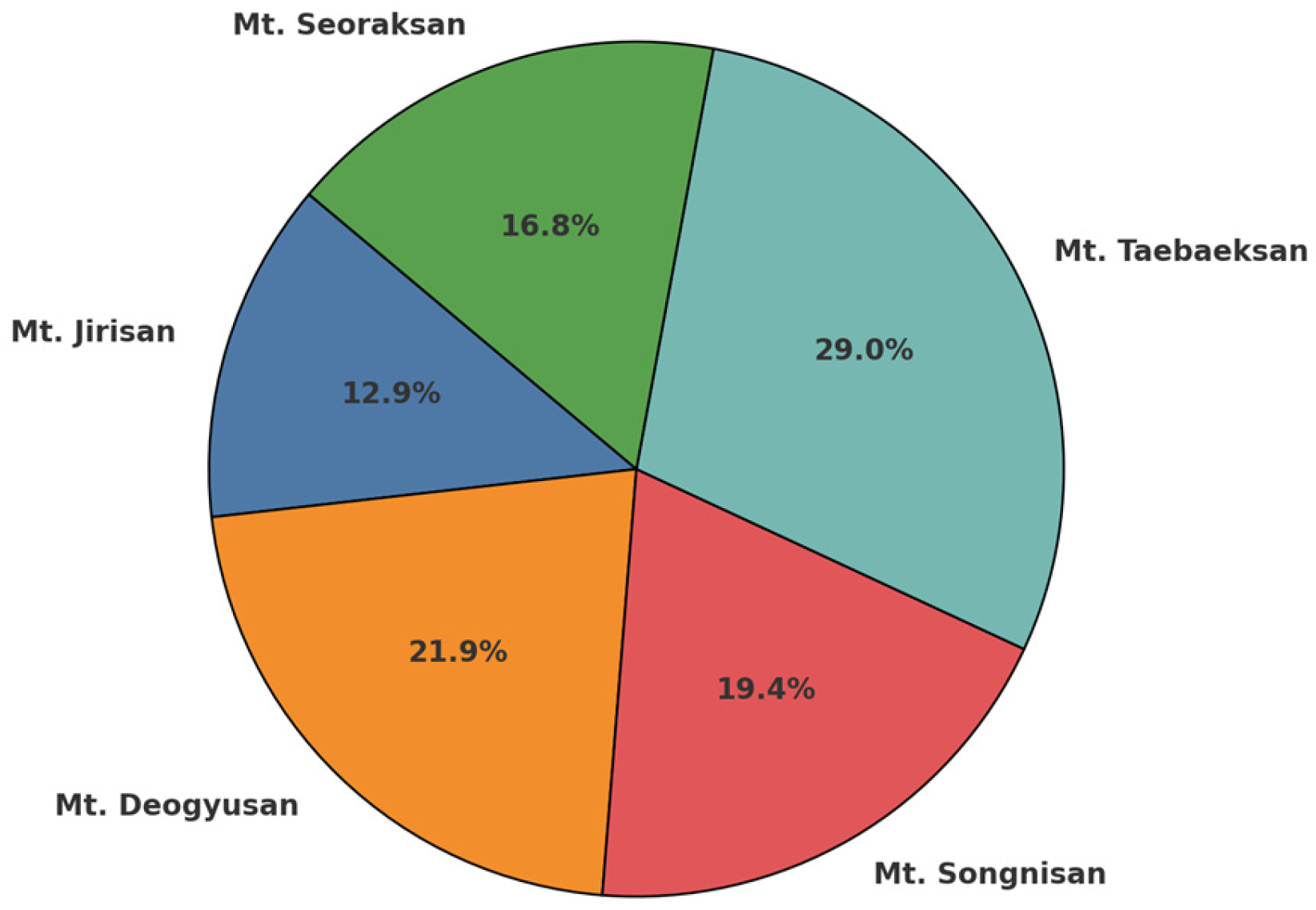
Figure 1. The location of the investigated sites in the Baekdudaegan Protected Area. The map shows the Baekdudaegan mountain range is divided into five regions: Seoraksan (red), Taebaeksan (orange), Songnisan (green), Deogyusan (blue), and Jirisan (purple). Within each region, disturbance sites are classified by type using different colored dots.
Diversity 17 00378 g001
Figure 2. The regional distribution of disturbed sites in the Baekdudaegan Protected Area.
Diversity 17 00378 g002
Figure 3. A comparison of the Naturalization Index (NI) and Urbanization Index (UI) across five mountain regions (left) and eight disturbance types (right), with the NI represented in yellow and UI in orange. The values indicate the proportion of each index based on species occurrence in disturbed sites.
Diversity 17 00378 g003
Figure 4. Sørensen similarity index between disturbed sites and reference ecosystems by region. The Sørensen similarity index was calculated based on species occurrence between disturbed sites and reference ecosystems in each region. The index ranges from 0 to 1, with higher values indicating greater similarity in species composition.
Diversity 17 00378 g004
Figure 5. Sørensen similarity index between disturbance types based on species occurrence; AL: arable land, BL/GL: bare land/grassland, CO/RA: cutover/restoration area, RO/FR: road/forest road, BG: burial ground, CS: construction, AQ: abandoned quarry, FA: farm, HT: hiking trail.
Diversity 17 00378 g005
Figure 6. NMDS analysis results illustrating differences in total floristic composition by disturbed site type. Each point represents a survey site, with closer proximity indicating a higher similarity in flora between regions.
Diversity 17 00378 g006
Figure 7. Hierarchical cluster analysis results depicting floristic similarity among disturbed site types, where closely grouped types share higher compositional similarity based on Bray–Curtis distances.
Diversity 17 00378 g007
Figure 8. SIMPER analysis results indicating the major species contributing to the total floristic composition by the disturbed site type.
Diversity 17 00378 g008
Figure 9. NMDS analysis results illustrating variations in alien plant composition by disturbed site type. Points represent survey sites, with closer proximity indicating higher compositional similarity.
Diversity 17 00378 g009
Figure 10. Hierarchical cluster analysis results illustrating similarity in alien plant composition among disturbed site types.
Diversity 17 00378 g010
Figure 11. SIMPER analysis results illustrating the dominant alien plant species contributing to floristic composition by the disturbed site type.
Diversity 17 00378 g011
Table 1. The status of the disturbance types and number of sites by region in the Baekdudaegan Protected Area.
LocationALBL/GLCO/RARO/FRBGCSAQFAHT
Mt. Jirisan785------
Mt. Deogyusan612733---3
Mt. Songnisan88434-3--
Mt. Taebaeksan184663134-
Mt. Seoraksan651716---
Total45372319117643
AL: Arable land, BL/GL: bare land/grassland, CO/RA: cutover/restoration area, RO/FR: road/forest road, BG: burial ground, CS: construction, AQ: abandoned quarry, FA: farm, HT: hiking trail.
Table 2. Vascular plant species composition in disturbed sites of the Baekdudaegan Protected Area.
TaxaFamilyGenusSpeciesSubspeciesVarietyFormaHybridTotal
Pteridophyta61114----14
Gymnospermae257----7
Angiospermae81287459151613494
Dicotyledons72228358131312387
Monocotyledons95910123-1107
Total89303480151613515
Table 3. Endemic plant species of the Korean peninsula in disturbed sites of the Baekdudaegan Protected Area.
Family NameScientific NameFreq.
SalicaceaePopulus × tomentiglandulosa T.B.Lee6
RanunculaceaeAnemone koraiensis Nakai3
Clematis trichotoma Nakai1
Clematis heracleifolia DC.
(KNA: Clematis urticifolia Nakai ex Kitag.)
1
ApiaceaeAngelica genuflexa Nutt.
(KNA: Angelica reflexa B.Y.Lee)
1
OleaceaeForsythia koreana (Rehder) Nakai1
CaprifoliaceaeWeigela subsessilis (Nakai) L.H.Bailey6
CaprifoliaceaePatrinia saniculifolia Hemsl.1
AsteraceaeAster koraiensis Nakai4
Cirsium setidens (Dunn) Nakai2
CyperaceaeCarex gifuensis Franch.
(KNA: Carex fusanensis Ohwi)
1
AsphodelaceaeHemerocallis hakuunensis Nakai3
KNA: Checklist of Vascular Plants in Korea (Korea National Arboretum).
Table 4. Red-list plant species of the Korean peninsula in disturbed sites of the Baekdudaegan Protected Area.
FamilyScientific NameDegreeFreq.
ApiaceaeBupleurum euphorbioides NakaiEN1
EricaceaeRhododendron micranthum Turcz.NT2
PrimulaceaeLysimachia pentapetala BungeVU1
PhrymaceaeErythranthe tenellus (Bunge) G.L.NesomNT1
EN: Endangerd, NT: near threatened, VU: vulnerable.
Disclaimer/Publisher’s Note: The statements, opinions and data contained in all publications are solely those of the individual author(s) and contributor(s) and not of MDPI and/or the editor(s). MDPI and/or the editor(s) disclaim responsibility for any injury to people or property resulting from any ideas, methods, instructions or products referred to in the content.

