
Citizen Science Contributions to Address Biodiversity Loss and Conservation Planning in a Rapidly Developing Region


Abstract
1. Introduction
2. Materials and Methods
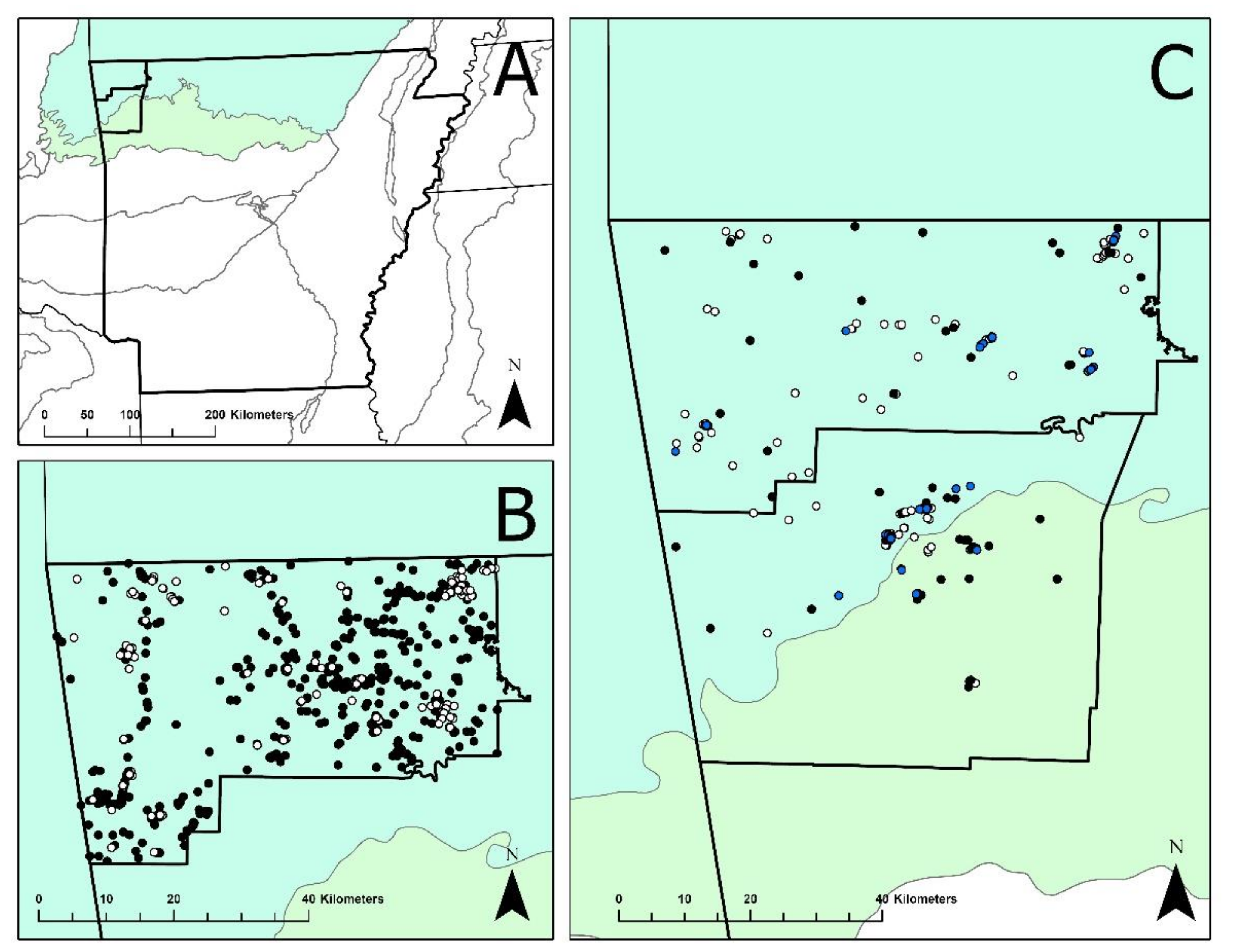
2.1. Study Area
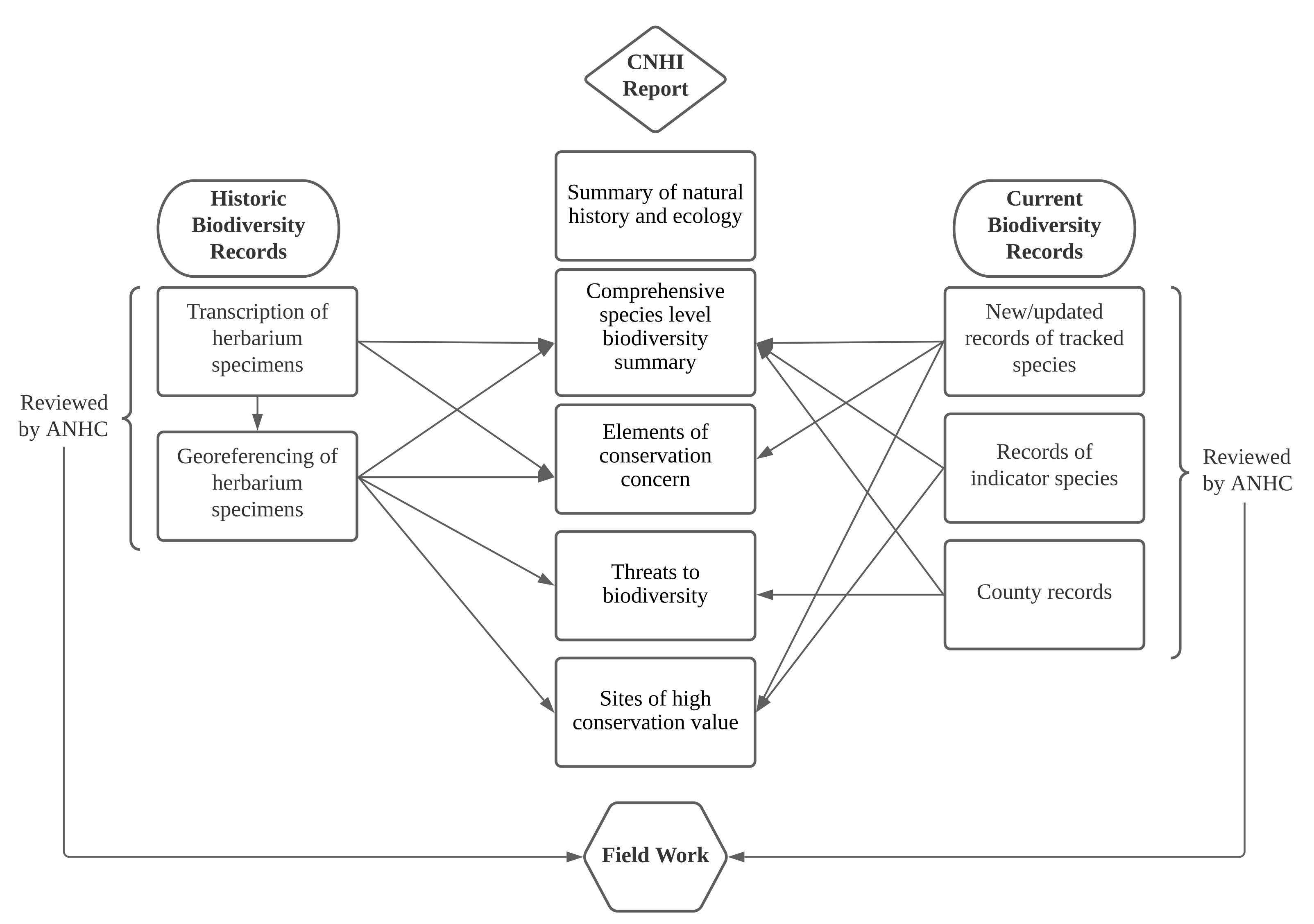
2.2. County Natural Heritage Inventory
2.3. Citizen Science Online Platforms
2.3.1. Notes from Nature—Plants of Arkansas Project
2.3.2. Collaborative Georeferencing—Arkansas Vascular Flora Project
2.3.3. iNaturalist
2.4. Analysis
2.4.1. Notes from Nature—Plants of Arkansas Project
2.4.2. Collaborative Georeferencing—Arkansas Vascular Flora Project
2.4.3. iNaturalist
3. Results
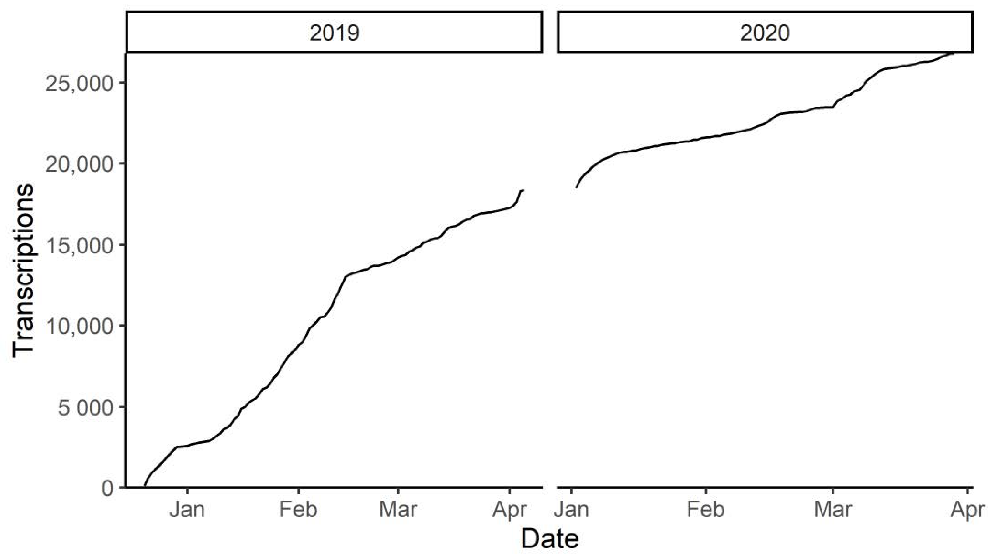
3.1. Notes from Nature—Plants of Arkansas Project
3.2. Collaborative Georeferencing—Arkansas Vascular Flora Project
3.3. iNaturalist
3.4. Citizen Science Contributions to the CNHI Report
4. Discussion
5. Conclusions
Supplementary Materials
Author Contributions
Funding
Institutional Review Board Statement
Informed Consent Statement
Data Availability Statement
Acknowledgments
Conflicts of Interest
Appendix A
References
- Albani Rocchetti, G.; Armstrong, C.G.; Abeli, T.; Orsenigo, S.; Jasper, C.; Joly, S.; Bruneau, A.; Zytaruk, M.; Vamosi, J.C. Reversing extinction trends: New uses of (old) herbarium specimens to accelerate conservation action on threatened species. New Phytol. 2021. [Google Scholar] [CrossRef] [PubMed]
- Pimm, S.L.; Jenkins, C.N.; Abell, R.; Brooks, T.M.; Gittleman, J.L.; Joppa, L.N.; Raven, P.H.; Roberts, C.M.; Sexton, J.O. The biodiversity of species and their rates of extinction, distribution, and protection. Science 2014, 344, 1246752. [Google Scholar] [CrossRef]
- Antonelli, A.; Fry, C.; Smith, R.; Simmonds, M.; Kersey, P.; Pritchard, H. The state of the world’s plants. Royal Botanic Gardens. Kew 2020. [Google Scholar] [CrossRef]
- Nic Lughadha, E.; Bachman, S.P.; Leão, T.C.; Forest, F.; Halley, J.M.; Moat, J.; Acedo, C.; Bacon, K.L.; Brewer, R.F.; Gâteblé, G. Extinction risk and threats to plants and fungi. Plants People Planet 2020, 2, 389–408. [Google Scholar] [CrossRef]
- Gillson, L.; Seymour, C.L.; Slingsby, J.A.; Inouye, D.W. What are the grand challenges for plant conservation in the 21st century? Front. Conserv. Sci. 2020, 1. [Google Scholar] [CrossRef]
- Lavoie, C. Biological collections in an ever changing world: Herbaria as tools for biogeographical and environmental studies. Perspect. Plant Ecol. Evol. Syst. 2013, 15, 68–76. [Google Scholar] [CrossRef]
- Delisle, F.; Lavoie, C.; Jean, M.; Lachance, D. Reconstructing the spread of invasive plants: Taking into account biases associated with herbarium specimens. J. Biogeogr. 2003, 30, 1033–1042. [Google Scholar] [CrossRef]
- Lavoie, C.; Joly, S.; Bergeron, A.; Guay, G.; Groeneveld, E. Explaining naturalization and invasiveness: New insights from historical ornamental plant catalogs. Ecol. Evol. 2016, 6, 7188–7198. [Google Scholar] [CrossRef]
- Lang, P.L.M.; Willems, F.M.; Scheepens, J.F.; Burbano, H.A.; Bossdorf, O. Using herbaria to study global environmental change. New Phytol. 2019, 221, 110–122. [Google Scholar] [CrossRef] [PubMed]
- McKinley, D.C.; Miller-Rushing, A.J.; Ballard, H.L.; Bonney, R.; Brown, H.; Cook-Patton, S.C.; Evans, D.M.; French, R.A.; Parrish, J.K.; Phillips, T.B.; et al. Citizen science can improve conservation science, natural resource management, and environmental protection. Biol. Conserv. 2017, 208, 15–28. [Google Scholar] [CrossRef]
- Chandler, M.; See, L.; Copas, K.; Bonde, A.M.; López, B.C.; Danielsen, F.; Legind, J.K.; Masinde, S.; Miller-Rushing, A.J.; Newman, G.; et al. Contribution of citizen science towards international biodiversity monitoring. Biol. Conserv. 2017, 213, 280–294. [Google Scholar] [CrossRef]
- Uyeda, K.A.; Stow, D.A.; Richart, C.H. Assessment of volunteered geographic information for vegetation mapping. Environ. Monit. Assess. 2020, 1–14. [Google Scholar] [CrossRef]
- Larson, E.R.; Graham, B.M.; Achury, R.; Coon, J.J.; Daniels, M.K.; Gambrell, D.K.; Jonasen, K.L.; King, G.D.; LaRacuente, N.; Perrin-Stowe, T.I.; et al. From eDNA to citizen science: Emerging tools for the early detection of invasive species. Front Ecol. Environ. 2020, 18, 194–202. [Google Scholar] [CrossRef]
- Ball-Damerow, J.E.; Brenskelle, L.; Barve, N.; Soltis, P.S.; Sierwald, P.; Bieler, R.; LaFrance, R.; Ariño, A.H.; Guralnick, R.P. Research applications of primary biodiversity databases in the digital age. PLoS ONE 2019, 14, e0215794. [Google Scholar] [CrossRef] [PubMed]
- Soltis, P.S.; Nelson, G.; James, S.A. Green digitization: Online botanical collections data answering real-world questions. Appl. Plant Sci. 2018, 6, e1028. [Google Scholar] [CrossRef]
- James, S.A.; Soltis, P.S.; Belbin, L.; Chapman, A.D.; Nelson, G.; Paul, D.L.; Collins, M. Herbarium data: Global biodiversity and societal botanical needs for novel research. Appl. Plant Sci. 2018, 6, e1024. [Google Scholar] [CrossRef]
- Young, B.E.; Dodge, N.; Hunt, P.D.; Ormes, M.; Schlesinger, M.D.; Shaw, H.Y. Using citizen science data to support conservation in environmental regulatory contexts. Biol. Conserv. 2019, 237, 57–62. [Google Scholar] [CrossRef]
- Burgess, H.K.; DeBey, L.B.; Froehlich, H.E.; Schmidt, N.; Theobald, E.J.; Ettinger, A.K.; HilleRisLambers , J.; Tewksbury , J.; Parrish , J.K. The science of citizen science: Exploring barriers to use as a primary research tool. Biol. Conserv. 2017, 208, 113–120. [Google Scholar] [CrossRef]
- Walls, S.C. Coping with constraints: Achieving effective conservation with limited resources. Front. Ecol. Evol. 2018, 6. [Google Scholar] [CrossRef]
- Magurran, A.E.; Baillie, S.R.; Buckland, S.T.; Dick, J.M.; Elston, D.A.; Scott, E.M.; Smith, R.I.; Somerfield, P.J.; Watt, A.D. Long-term datasets in biodiversity research and monitoring: Assessing change in ecological communities through time. Trends Ecol. Evol. 2010, 25, 574–582. [Google Scholar] [CrossRef]
- Theobald, E.J.; Ettinger, A.K.; Burgess, H.K.; DeBey, L.B.; Schmidt, N.R.; Froehlich, H.E.; Wagner, C.; HilleRisLambers, J.; Tewksbury, J.; Harsch, M.A. Global change and local solutions: Tapping the unrealized potential of citizen science for biodiversity research. Biol. Conserv. 2015, 181, 236–244. [Google Scholar] [CrossRef]
- Ariño, A.H. Approaches to estimating the universe of natural history collections data. Biodivers Inform. 2010, 7, 81–92. [Google Scholar] [CrossRef]
- Blagoderov, V.; Kitching, I.J.; Livermore, L.; Simonsen, T.J.; Smith, V.S. No specimen left behind: Industrial scale digitization of natural history collections. ZooKeys 2012, 133–146. [Google Scholar] [CrossRef]
- Granzow-de la Cerda, I.; Beach, J.H. Semi-automated workflows for acquiring specimen data from label images in herbarium collections. Taxon 2010, 59, 1830–1842. [Google Scholar] [CrossRef]
- Vollmar, A.; Macklin, J.A.; Ford, L. Natural history specimen digitization: Challenges and concerns. Biodivers Inform. 2010, 7, 93–112. [Google Scholar] [CrossRef]
- Ballard, H.L.; Robinson, L.D.; Young, A.N.; Pauly, G.B.; Higgins, L.M.; Johnson, R.F.; Tweddle, J.C. Contributions to conservation outcomes by natural history museum-led citizen science: Examining evidence and next steps. Biol. Conserv. 2017, 208, 87–97. [Google Scholar] [CrossRef]
- Arts, K.; van der Wal, R.; Adams, W.M. Digital technology and the conservation of nature. Ambio 2015, 44, 661–673. [Google Scholar] [CrossRef]
- Sauermann, H.; Franzoni, C. Crowd science user contribution patterns and their implications. Proc. Natl. Acad. Sci. USA 2015, 112, 679–684. [Google Scholar] [CrossRef] [PubMed]
- Miller-Rushing, A.; Primack, R.; Bonney, R. The history of public participation in ecological research. Front Ecol. Environ. 2012, 10, 285–290. [Google Scholar] [CrossRef]
- Strasser, B.J. Collecting nature: Practices, styles, and narratives. Osiris 2012, 27, 303–340. [Google Scholar] [CrossRef]
- Sforzi, A.; Tweddle, J.; Vogel, J.; Lois, G.; Wägele, W.; Lakeman-Fraser, P.; Makuch, Z.; Vohland, K. Citizen science and the role of natural history museums. Citiz. Sci. 2019, 429–444. [Google Scholar] [CrossRef]
- Newman, G.; Chandler, M.; Clyde, M.; McGreavy, B.; Haklay, M.; Ballard, H.; Gray, S.; Scarpino, R.; Hauptfeld, R.; Mellor, D.; et al. Leveraging the power of place in citizen science for effective conservation decision making. Biol. Conserv. 2017, 208, 55–64. [Google Scholar] [CrossRef]
- Oswald, E. Getting to know other ways of knowing: Boundary experiences in citizen science. Citiz. Sci. Theory Pract. 2020, 5, 1–15. [Google Scholar] [CrossRef]
- Ellwood, E.; Bart, H., Jr.; Doosey, M.; Jue, D.; Mann, J.; Nelson, G.; Rios, N.; Mast, A. Mapping life-quality assessment of novice vs. expert georeferencers. Citiz. Sci. Theory Pract. 2016, 1, 1–12. [Google Scholar] [CrossRef]
- Ellwood, E.R.; Dunckel, B.A.; Flemons, P.; Guralnick, R.; Nelson, G.; Newman, G.; Newman, S.; Paul, D.; Riccardi, G.; Rios, N.; et al. Accelerating the digitization of biodiversity research specimens through online public participation. Bioscience 2015, 65, 383–396. [Google Scholar] [CrossRef]
- Reynolds, R.; Liang, L.; Li, X.C.; Dennis, J. Monitoring annual urban changes in a rapidly growing portion of northwest Arkansas with a 20-year landsat record. Remote Sens. 2017, 9, 71. [Google Scholar] [CrossRef]
- Omernik, J.M. Map Supplement Ecoregions of the Conterminous United States. Ann. Assoc. Am. Geogr. 1987, 77, 118–125. [Google Scholar] [CrossRef]
- Gentry, J.L.; Johnson, G.P.; Baker, B.T.; Witsell, C.T.; Ogle, J.D. Atlas of the Vascular Plants of Arkansas, 1st ed.; University of Arkansas: Fayetteville, AR, USA, 2013; pp. 1–709. [Google Scholar]
- Davis, A.F. County Natural Areas Inventory. Bartonia 1993, 57, 58–60. [Google Scholar]
- Groves, C.R.; Klein, M.L.; Breden, T.F. Natural Heritage Programs: Public-Private Partnerships for Biodiversity Conservation. Wildl. Soc. Bull. 1995, 23, 784–790. [Google Scholar]
- Witsell, T.; McDaniel, V.L.; Baker, B.T.; Zollner, D.M.; De Jong, G.L.; Hooks, S.L. Coefficients of conservatism for the vascular flora of Arkansas. Phytoneuron. in revision.
- Hill, A.; Guralnick, R.; Smith, A.; Sallans, A.; Gillespie, R.; Denslow, M.; Gross, J.; Murrell, Z.; Conyers, T.; Oboyski, P.; et al. The Notes from Nature tool for unlocking biodiversity records from museum records through citizen science. Zookeys 2012, 209, 219–233. [Google Scholar] [CrossRef] [PubMed]
- Soteropoulos, D.L.; Marsico, T.D. Building a student and volunteer network for Notes from Nature herbarium transcription success in Arkansas. Zookeys, in review.
- SERNEC Data Portal. Available online: http//:sernecportal.org/portal/index.php (accessed on 20 March 2021).
- R Core Team. R: A Language and Environment for Statistical Computing; R Foundation for Statistical Computing: Vienna, Austria; Available online: https://www.R-project.org/ (accessed on 15 January 2021).
- Esri Inc. ArcGIS Pro (Version 2.4.0). Esri Inc. Available online: https://www.esri.com/en-us/arcgis/products/arcgis-pro/overview (accessed on 8 April 2021).
- Arkansas GIS Office. County Boundary (Polygons) (Version 6.2 (Build 9200); Esri ArcGIS 10.6.0.8321). Arkansas GIS Office. Available online: https://gis.arkansas.gov/product/county-boundary-polygons/ (accessed on 8 April 2021).
- Arkansas Natural Heritage Commission. Arkansas Natural Heritage Database. Available online: https://www.arkansasheritage.com/arkansas-natural-heritage/programs/data-requests (accessed on 19 March 2021).
- Lynch, D.T.; Witsell, C.T.; Rupar, B.A.; Holimon, W.C.; Bowman, D.W. The devil and the deep blue lake: How natural area acquisition and stewardship helps protect the major drinking reservoir in northwestern Arkansas. Nat. Areas J. 2019, 39, 58–77. [Google Scholar] [CrossRef]
- Arkansas State Highway and Transportation Department. General Highway Map Benton County Arkansas 2010. Available online: https://www.mapofus.org/_maps/dot/ar/BentonCounty.pdf (accessed on 20 March 2021).
- Daru, B.H.; Park, D.S.; Primack, R.B.; Willis, C.G.; Barrington, D.S.; Whitfeld, T.J.; Seidler, T.G.; Sweeney, P.W.; Foster, D.R.; Ellison, A.M.; et al. Widespread sampling biases in herbaria revealed from large-scale digitization. New Phytol. 2018, 217, 939–955. [Google Scholar] [CrossRef] [PubMed]


| User Group | Number of Users | Total Transcriptions | Percent of Total | Transcriptions per User | Total Days | Mean Days per User |
|---|---|---|---|---|---|---|
| CAMN | 9 | 10851 | 40.48 | 1206 | 277 | 30.78 |
| Mega-contributor | 4 | 9157 | 34.16 | 2289 | 139 | 34.75 |
| NWAMN | 39 | 2516 | 9.39 | 65 | 190 | 4.87 |
| Unassigned | 48 | 1418 | 5.29 | 30 | 141 | 2.94 |
| Not logged in | Unknown | 1316 | 4.91 | N/A | N/A | N/A |
| Team | 3 | 921 | 3.44 | 307 | 118 | 39.33 |
| A-State | 48 | 535 | 2.00 | 11 | 50 | 1.04 |
| Other AMN and ANPS | 6 | 92 | 0.34 | 15 | 15 | 2.50 |
| Type of Record | Benton | Washington | ||||
|---|---|---|---|---|---|---|
| Count | Taxa | Citizen Scientists | Count | Taxa | Citizen Scientists | |
| New population records of tracked taxa | 26 | 14 | 14 | 35 | 16 | 9 |
| Updated population records of tracked taxa | 31 | 14 | 11 | 33 | 14 | 12 |
| Populations of indicator taxa | 20 | 10 | 13 | 24 | 10 | 11 |
| County records | 85 1 | 85 1 (14) 2 | 47 | 53 1 | 53 1 (11) 2 | 19 |
Publisher’s Note: MDPI stays neutral with regard to jurisdictional claims in published maps and institutional affiliations. |
© 2021 by the authors. Licensee MDPI, Basel, Switzerland. This article is an open access article distributed under the terms and conditions of the Creative Commons Attribution (CC BY) license (https://creativecommons.org/licenses/by/4.0/).
Share and Cite
Soteropoulos, D.L.; De Bellis, C.R.; Witsell, T. Citizen Science Contributions to Address Biodiversity Loss and Conservation Planning in a Rapidly Developing Region. Diversity 2021, 13, 255. https://doi.org/10.3390/d13060255
Soteropoulos DL, De Bellis CR, Witsell T. Citizen Science Contributions to Address Biodiversity Loss and Conservation Planning in a Rapidly Developing Region. Diversity. 2021; 13(6):255. https://doi.org/10.3390/d13060255
Chicago/Turabian StyleSoteropoulos, Diana L., Caitlin R. De Bellis, and Theo Witsell. 2021. "Citizen Science Contributions to Address Biodiversity Loss and Conservation Planning in a Rapidly Developing Region" Diversity 13, no. 6: 255. https://doi.org/10.3390/d13060255
APA StyleSoteropoulos, D. L., De Bellis, C. R., & Witsell, T. (2021). Citizen Science Contributions to Address Biodiversity Loss and Conservation Planning in a Rapidly Developing Region. Diversity, 13(6), 255. https://doi.org/10.3390/d13060255