
Do Citizen Science Methods Identify Regions of High Avian Biodiversity?


Abstract
:1. Introduction
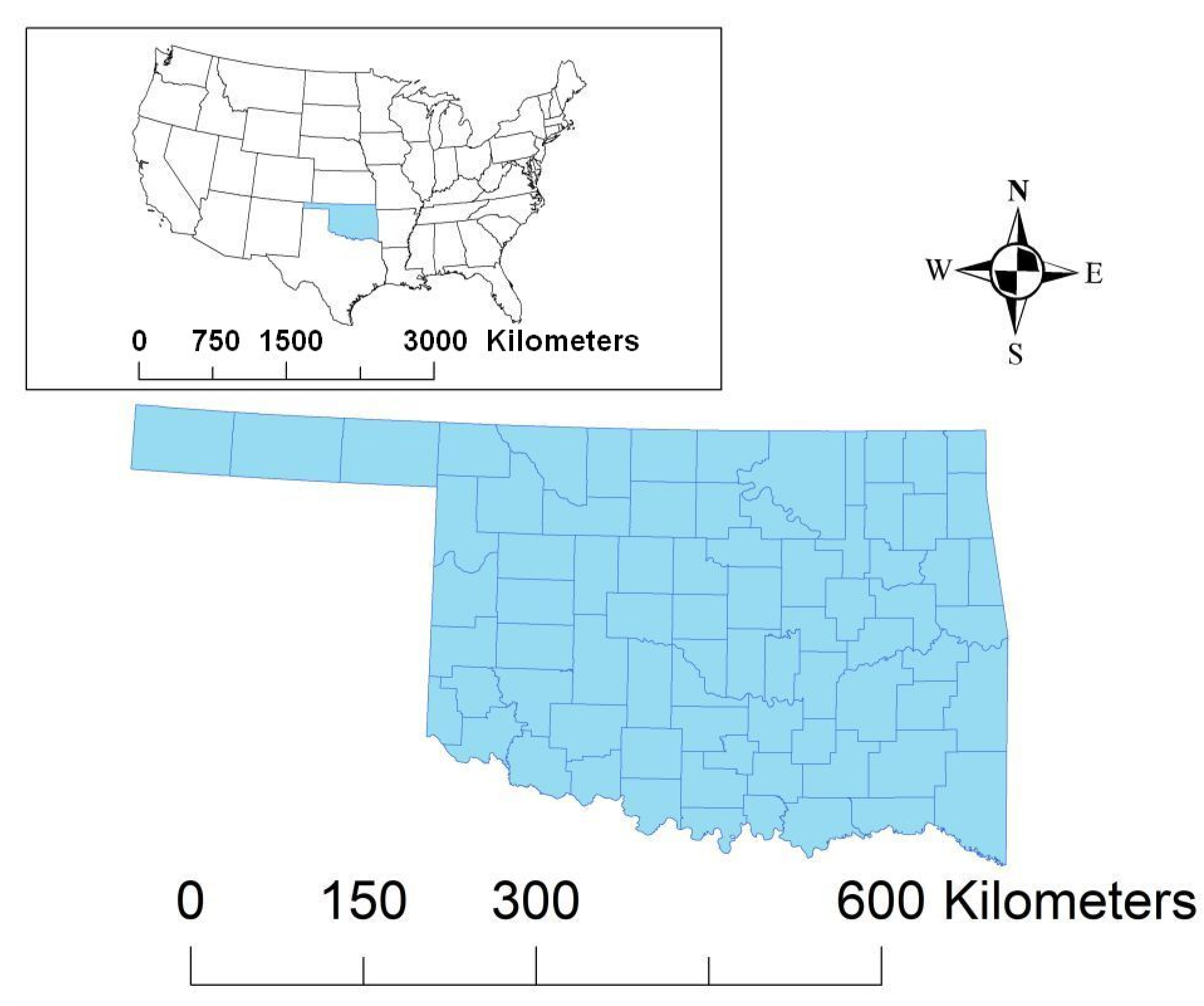
2. Materials and Methods
3. Results
4. Discussion
5. Conclusions
Author Contributions
Funding
Institutional Review Board Statement
Data Availability Statement
Acknowledgments
Conflicts of Interest
References
- Devictor, V.; Whittaker, R.; Beltrame, C. Beyond scarcity: Citizen science programmes as useful tools for conservation biogeography. Divers. Distrib. 2010, 16, 354–362. [Google Scholar] [CrossRef]
- Silvertown, J. A new dawn for citizen science. Trends Ecol. Evol. 2009, 24, 467–471. [Google Scholar] [CrossRef] [PubMed]
- Hochachka, W.; Fink, D.; Hutchinson, R.A.; Sheldon, D.; Wong, W.-K.; Kelling, S. Data-Intensive science applied to broad-scale citizen science. Trends Ecol. Evol. 2012, 27, 130–137. [Google Scholar] [CrossRef] [PubMed]
- Supp, S.R.; La Sorte, F.A.; Cormier, T.A.; Lim, M.C.; Powers, D.R.; Wethington, S.M.; Goetz, S.; Graham, C.H. Citizen-Science data provides new insight into annual and seasonal variation in migration patterns. Ecosphere 2015, 6, art15. [Google Scholar] [CrossRef]
- Bonney, R.; Cooper, C.B.; Dickinson, J.; Kelling, S.; Phillips, T.; Rosenberg, K.V.; Shirk, J. Citizen science: A developing tool for expanding science knowledge and scientific literacy. BioScience 2009, 59, 977–984. [Google Scholar] [CrossRef]
- Dickinson, J.L.; Zuckerberg, B.; Bonter, D.N. Citizen science as an ecological research tool: Challenges and benefits. Annu. Rev. Ecol. Evol. Syst. 2010, 41, 149–172. [Google Scholar] [CrossRef] [Green Version]
- Franzoni, C.; Sauermann, H. Crowd science: The organization of scientific research in open collaborative projects. Res. Policy 2014, 43, 1–20. [Google Scholar] [CrossRef] [Green Version]
- Yaukey, P.H. Citizen science and bird–distribution data: An opportunity for geographical research. Geogr. Rev. 2010, 100, 263–273. [Google Scholar] [CrossRef]
- Kelling, S.; Johnston, A.; Hochachka, W.M.; Iliff, M.; Fink, D.; Gerbracht, J.; Lagoze, C.; La Sorte, F.A.; Moore, T.; Wiggins, A.; et al. Can observation skills of citizen scientists be estimated using species accumulation curves? PLoS ONE 2015, 10, e0139600. [Google Scholar] [CrossRef] [PubMed] [Green Version]
- Sauer, J.R.; Link, W.A.; Fallon, J.E.; Pardieck, K.; Ziolkowski, D.J. The North American Breeding Bird Survey 1966–2011: Summary Analysis and Species Accounts. N. Am. Fauna 2013, 79, 1–32. [Google Scholar] [CrossRef] [Green Version]
- Hof, A.R.; Bright, P.W. Quantifying the long-term decline of the West European hedgehog in England by subsampling citizen-science datasets. Eur. J. Wildl. Res. 2016, 62, 407–413. [Google Scholar] [CrossRef]
- Lee, T.; Kahal, N.; Kinas, H.; Randall, L.; Baker, T.; Carney, V.; Kendell, K.; Sanderson, K.; Duke, D. Advancing Amphibian Conservation through Citizen Science in Urban Municipalities. Diversity 2021, 13, 211. [Google Scholar] [CrossRef]
- Soteropoulos, D.; De Bellis, C.; Witsell, T. Citizen Science Contributions to Address Biodiversity Loss and Conservation Planning in a Rapidly Developing Region. Diversity 2021, 13, 255. [Google Scholar] [CrossRef]
- Souther, S.; Randall, V.; Lyndon, N. The Use of Citizen Science to Achieve Multivariate Management Goals on Public Lands. Diversity 2021, 13, 293. [Google Scholar] [CrossRef]
- Falk, B.G.; Snow, R.W.; Reed, R.N. Prospects and Limitations of Citizen Science in Invasive Species Management: A Case Study with Burmese Pythons in Everglades National Park. Southeast. Nat. 2016, 15, 89–102. [Google Scholar] [CrossRef]
- Dunn, E.H.; Francis, C.M.; Blancher, P.J.; Drennan, S.R.; Howe, M.A.; Lepage, D.; Robbins, C.S.; Rosenberg, K.V.; Sauer, J.R.; Smith, K.G. Enhancing the scientific value of the Christmas Bird Count. Auk 2005, 122, 338–346. [Google Scholar] [CrossRef]
- Sánchez-Clavijo, L.M.; Martínez-Callejas, S.J.; Acevedo-Charry, O.; Diaz-Pulido, A.; Gómez-Valencia, B.; Ocampo-Peñuela, N.; Ocampo, D.; Olaya-Rodríguez, M.H.; Rey-Velasco, J.C.; Soto-Vargas, C.; et al. Differential reporting of biodiversity in two citizen science platforms during COVID-19 lockdown in Colombia. Biol. Conserv. 2021, 256, 109077. [Google Scholar] [CrossRef]
- Rotenberry, J.T. Components of avian diversity along a multifactorial gradient. Ecology 1978, 59, 693–699. [Google Scholar] [CrossRef]
- Tews, J.; Brose, U.; Grimm, V.; Tielbörger, K.; Wichmann, M.C.; Schwager, M.; Jeltsch, F. Animal species diversity driven by habitat heterogeneity/diversity: The importance of keystone structures. J. Biogeogr. 2004, 31, 79–92. [Google Scholar] [CrossRef] [Green Version]
- United States Geological Survey. Elevations and Distances in the United States. 2001. Available online: https://pubs.usgs.gov/gip/Elevations-Distances/elvadist.html (accessed on 29 August 2021).
- United States Census Bureau. 2010 Census: Oklahoma Profile. 2018. Available online: https://www2.census.gov/geo/pdfs/reference/guidestloc/40_Oklahoma.pdf (accessed on 29 August 2021).
- Omernik, J.M. Ecoregions of the conterminous United States. Ann. Am. Assoc. Geogr. 1987, 77, 118–125. [Google Scholar] [CrossRef]
- Woods, A.J.; Omernik, J.M.; Butler, D.R.; Ford, J.G.; Henley, J.E.; Hoagland, B.W.; Arndt, D.S.; Moran, B.C. Ecoregions of Oklahoma (Color Poster with Map, Descriptive Text, Summary Tables, and Photographs); U.S. Geological Survey: Reston, VA, USA, 2005; (map scale 1:1,250,000). [Google Scholar]
- Constable, H.; Guralnick, R.; Wieczorek, J.; Spencer, C.; Peterson, A.T. VertNet Steering Committee VertNet: A New Model for Biodiversity Data Sharing. PLoS Biol. 2010, 8, e1000309. [Google Scholar] [CrossRef]
- Gurlanick, R.; Constable, H. VertNet: Creating a data-sharing community. BioScience 2010, 60, 258–259. [Google Scholar] [CrossRef] [Green Version]
- Vertnet. 2016. VertNet© Version 2016-09-29. Available online: http://vertnet.org/ (accessed on 29 August 2021).
- Reinking, D.L. (Ed.) Oklahoma Breeding Bird Atlas; University of Oklahoma Press: Norman, OK, USA, 2004. [Google Scholar]
- Sullivan, B.L.; Wood, C.L.; Iliff, M.J.; Bonney, R.E.; Fink, D.; Kelling, S. eBird: A citizen-based bird observation network in the biological sciences. Biol. Conserv. 2009, 142, 2282–2292. [Google Scholar] [CrossRef]
- Reinking, D.L. (Ed.) Oklahoma Winter Bird Atlas; University of Oklahoma Press: Norman, OK, USA, 2017. [Google Scholar]
- National Audubon Society. Christmas Bird Count CBC Results. 2021. Available online: https://netapp.audubon.org/cbcobservation/ (accessed on 29 August 2021).
- Birdlife International and NatureServe. Digital Distribution Maps of the Birds of the Western Hemisphere. 2021. Available online: https://www.natureserve.org/products/digital-distribution-maps-birds-western-hemisphere (accessed on 29 August 2021).
- U.S. Fish and Wildlife Service. Birds of Conservation Concern 2008; United States Department of Interior, Fish and Wildlife Service, Division of Migratory Bird Management: Arlington, VA, USA, 2008. [Google Scholar]
- Oklahoma Bird Records Committee. The Oklahoma Ornithological Society Checklist of Oklahoma Birds, 4th ed.; Oklahoma Ornithological Society: Norman, OK, USA, 2011. [Google Scholar]
- Chesser, R.T.; Billerman, S.M.; Burns, K.J.; Cicero, C.; Dunn, J.L.; Hernández-Baños, B.E.; Kratter, A.W.; Lovette, I.J.; Mason, N.A.; Rasmussen, P.C.; et al. Check-List of North American Birds (Online). American Ornithological Society. 2021. Available online: http://checklist.aou.org/taxa (accessed on 26 November 2021).
- American Ornithologists’ Union. Check-List of North American Birds, 7th ed.; American Ornithologists’ Union: Washington, DC, USA, 1998. [Google Scholar]
- Bray, J.R.; Curtis, J.T. An Ordination of the Upland Forest Communities of Southern Wisconsin. Ecol. Monogr. 1957, 27, 325–349. [Google Scholar] [CrossRef]
- Haskell, D.G.; Evans, J.P.; Pelkey, N.W. Depauperate Avifauna in Plantations Compared to Forests and Exurban Areas. PLoS ONE 2006, 1, e63. [Google Scholar] [CrossRef]
- Gillings, S. Designing a winter bird atlas field methodology: Issues of time and space in sampling and interactions with habitat. J. Ornithol. 2008, 149, 345–355. [Google Scholar] [CrossRef]
- Cooper, C.B.; Dickinson, J.; Phillips, T.; Bonney, R. Citizen Science as a Tool for Conservation in Residential Ecosystems. Ecol. Soc. 2007, 12, 11. [Google Scholar] [CrossRef]
- Rosenzweig, M.L. Species Diversity in Space and Time; Cambridge University Press: Cambridge, UK, 1995. [Google Scholar]
- Lepczyk, C.A. Integrating published data and citizen science to describe bird diversity across a landscape. J. Appl. Ecol. 2005, 42, 672–677. [Google Scholar] [CrossRef]
- Gotelli, N.J.; Colwell, R.K. Quantifying biodiversity: Procedures and pitfalls in the measurement and comparison of species richness. Ecol. Lett. 2001, 4, 379–391. [Google Scholar] [CrossRef] [Green Version]
- United States Department of Agriculture—Forest Service. Bird Checklist: Red Slough Wildlife Management Area. 2019. Available online: https://www.fs.usda.gov/Internet/FSE_DOCUMENTS/stelprdb5163358.pdf (accessed on 27 November 2021).
- Phillips, S.J.; Anderson, R.P.; Schapire, R.E. Maximum entropy modeling of species geographic distributions. Ecol. Model. 2006, 190, 231–259. [Google Scholar] [CrossRef] [Green Version]
- Mackenzie, D.I.; Nichols, J.D.; Lachman, G.B.; Droege, S.; Royle, J.A.; Langtimm, C.L. Estimating site occupancy rates when detection probabilities are less than one. Ecology 2002, 83, 2248–2255. [Google Scholar] [CrossRef]
- Csuti, B.; O’Neil, T.A.; Shaughnessy, M.M.; Gaines, E.P.; Hak, J.C. Atlas of Oregon Wildlife: Distribution, Habitat, and Natural History, 2nd ed.; Oregon State University Press: Corvallis, OR, USA, 2001. [Google Scholar]
- Jenkins, C.N.; Van Houtan, K.S.; Pimm, S.L.; Sexton, J.O. US protected lands mismatch biodiversity priorities. Proc. Natl. Acad. Sci. USA 2015, 112, 5081–5086. [Google Scholar] [CrossRef] [PubMed] [Green Version]
- Pimm, S.L.; Jenkins, C.N.; Abell, R.; Brooks, T.M.; Gittleman, J.L.; Joppa, L.N.; Raven, P.H.; Roberts, C.M.; Sexton, J.O. The biodiversity of species and their rates of extinction, distribution, and protection. Science 2014, 344, 1246752. [Google Scholar] [CrossRef] [PubMed]


| Species | Species |
|---|---|
| Lesser Prairie-Chicken (Tympanuchus pallidicinctus) | Gray Vireo (Vireo vicinior) |
| Yellow Rail (Coturnicops noveboracensis) | Loggerhead Shrike (Lanius ludovicianus) |
| Black Rail (Laterallus jamaicensis) | Pinyon Jay (Gymnorhinus cyanocephalus) |
| Wilson’s Plover (Charadrius wilsonia) | Brown-headed Nuthatch (Sitta pusilla) |
| Mountain Plover (Charadrius montanus) | Sedge Wren (Cistothorus stellaris) |
| Snowy Plover (Charadrius nivosus) | Wood Thrush (Hylocichla mustelina) |
| Upland Sandpiper (Bartramia longicauda) | Sprague’s Pipit (Anthus spragueii) |
| Whimbrel (Numenius phaeopus) | Chestnut-collared Longspur (Calcarius ornatus) |
| Long-billed Curlew (Numenius americanus) | Smith’s Longspur (Calcarius pictus) |
| Hudsonian Godwit (Limosa haemastica) | Thick-billed Longspur (Rhynchophanes mccownii) |
| Red Knot (Calidris canutus) | Bachman’s Sparrow (Peucaea aestivalis) |
| Buff-breasted Sandpiper (Calidris subruficollis) | Lark Bunting (Calamospiza melanocorys) |
| Short-billed Dowitcher (Limnodromus griseus) | Harris’s Sparrow (Zonotrichia querula) |
| Solitary Sandpiper (Tringa solitaria) | LeConte’s Sparrow (Ammospiza leconteii) |
| Lesser Yellowlegs (Tringa flavipes) | Nelson’s Sparrow (Ammospiza nelsoni) |
| Black Skimmer (Rynchops niger) | Baird’s Sparrow (Centronyx bairdii) |
| Reddish Egret (Egretta rufescens) | Henslow’s Sparrow (Centronyx henslowii) |
| Swallow-tailed Kite (Elanoides forficatus) | Rusty Blackbird (Euphagus carolinus) |
| Golden Eagle (Aquila chrysaetos) | Worm-eating Warbler (Helmitheros vermivorum) |
| Bald Eagle (Haliaeetus leucocephalus) | Prothonotary Warbler (Protonotaria citrea) |
| Burrowing Owl (Athene cunicularia) | Swainson’s Warbler (Limnothlypis swainsonii) |
| Lewis’s Woodpecker (Melanerpes lewis) | Kentucky Warbler (Geothlypis formosa) |
| Red-headed Woodpecker (Melanerpes erythrocephalus) | Cerulean Warbler (Setophaga cerulea) Prairie Warbler (Setophaga discolor) |
| Peregrine Falcon (Falco peregrinus) | Grace’s Warbler (Setophaga graciae) |
| Bell’s Vireo (Vireo bellii) | Painted Bunting (Passerina ciris) |
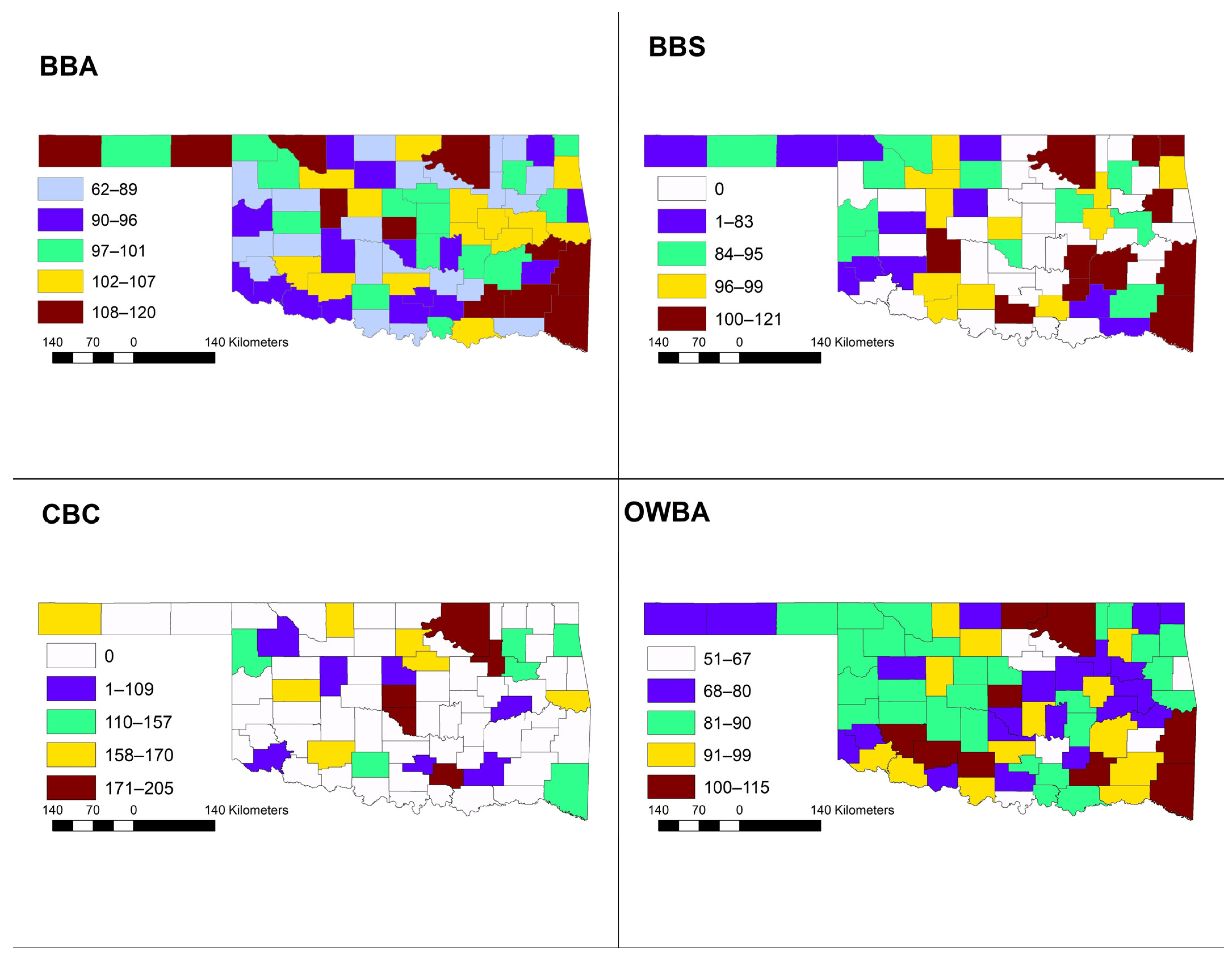
| County | OBBA | BBS | eBird | OWBA | NatureServe | CBC | Museum | Total Sp. |
|---|---|---|---|---|---|---|---|---|
| Adair | 92 | 126 | 62 | 153 | 27 | 211 | ||
| Alfalfa | 96 | 98 | 266 | 93 | 139 | 170 | 76 | 300 |
| Atoka | 109 | 78 | 186 | 107 | 151 | 109 | 24 | 237 |
| Beaver | 112 | 83 | 202 | 89 | 131 | 57 | 245 | |
| Beckham | 83 | 95 | 166 | 86 | 143 | 15 | 222 | |
| Blaine | 112 | 96 | 206 | 99 | 141 | 87 | 57 | 268 |
| Bryan | 105 | 206 | 89 | 152 | 25 | 248 | ||
| Caddo | 95 | 107 | 183 | 88 | 145 | 58 | 238 | |
| Canadian | 86 | 268 | 83 | 149 | 111 | 297 | ||
| Carter | 91 | 101 | 213 | 77 | 150 | 14 | 256 | |
| Cherokee | 101 | 112 | 223 | 86 | 155 | 15 | 254 | |
| Choctaw | 81 | 75 | 150 | 95 | 151 | 47 | 226 | |
| Cimarron | 120 | 81 | 279 | 71 | 133 | 159 | 206 | 328 |
| Cleveland | 91 | 95 | 287 | 77 | 150 | 179 | 274 | 335 |
| Coal | 62 | 103 | 92 | 72 | 146 | 21 | 200 | |
| Comanche | 107 | 96 | 284 | 103 | 152 | 165 | 62 | 312 |
| Cotton | 92 | 97 | 168 | 71 | 148 | 7 | 228 | |
| Craig | 92 | 101 | 114 | 74 | 149 | 44 | 208 | |
| Creek | 103 | 93 | 182 | 75 | 148 | 3 | 233 | |
| Custer | 98 | 82 | 230 | 87 | 142 | 170 | 54 | 278 |
| Delaware | 106 | 98 | 194 | 84 | 153 | 141 | 44 | 257 |
| Dewey | 78 | 180 | 75 | 143 | 39 | 230 | ||
| Ellis | 89 | 170 | 81 | 142 | 128 | 70 | 239 | |
| Garfield | 91 | 93 | 213 | 93 | 144 | 4 | 255 | |
| Garvin | 105 | 135 | 92 | 151 | 15 | 224 | ||
| Grady | 89 | 190 | 89 | 149 | 35 | 242 | ||
| Grant | 85 | 79 | 126 | 72 | 144 | 13 | 216 | |
| Greer | 71 | 83 | 179 | 76 | 147 | 61 | 238 | |
| Harmon | 92 | 79 | 145 | 78 | 147 | 49 | 218 | |
| Harper | 99 | 77 | 194 | 87 | 136 | 52 | 246 | |
| Haskell | 112 | 116 | 78 | 153 | 49 | 211 | ||
| Hughes | 101 | 101 | 160 | 89 | 151 | 23 | 225 | |
| Jackson | 96 | 201 | 98 | 152 | 100 | 54 | 255 | |
| Jefferson | 83 | 169 | 97 | 152 | 16 | 239 | ||
| Johnston | 95 | 99 | 267 | 82 | 143 | 176 | 93 | 294 |
| Kay | 107 | 196 | 106 | 147 | 77 | 251 | ||
| Kingfisher | 103 | 77 | 130 | 86 | 146 | 13 | 221 | |
| Kiowa | 103 | 77 | 210 | 101 | 148 | 44 | 261 | |
| Latimer | 93 | 120 | 64 | 150 | 41 | 209 | ||
| LeFlore | 120 | 121 | 198 | 105 | 155 | 68 | 247 | |
| Lincoln | 97 | 141 | 75 | 148 | 10 | 212 | ||
| Logan | 99 | 191 | 85 | 145 | 75 | 21 | 240 | |
| Love | 89 | 171 | 62 | 152 | 21 | 226 | ||
| Major | 104 | 98 | 150 | 84 | 138 | 18 | 224 | |
| Marshall | 97 | 176 | 88 | 147 | 167 | 256 | ||
| Mayes | 89 | 175 | 87 | 149 | 76 | 232 | ||
| McClain | 72 | 211 | 69 | 150 | 125 | 254 | ||
| McCurtain | 114 | 113 | 316 | 105 | 155 | 149 | 110 | 327 |
| McIntosh | 105 | 158 | 80 | 150 | 51 | 27 | 226 | |
| Murray | 92 | 193 | 84 | 144 | 28 | 129 | 256 | |
| Muskogee | 104 | 92 | 196 | 78 | 154 | 51 | 251 | |
| Noble | 76 | 210 | 51 | 147 | 160 | 22 | 260 | |
| Nowata | 83 | 162 | 83 | 146 | 45 | 230 | ||
| Okfuskee | 105 | 139 | 87 | 149 | 10 | 211 | ||
| Oklahoma | 111 | 98 | 286 | 102 | 150 | 205 | 189 | 330 |
| Okmulgee | 106 | 99 | 178 | 96 | 152 | 50 | 233 | |
| Osage | 119 | 107 | 268 | 115 | 154 | 175 | 80 | 301 |
| Ottawa | 98 | 103 | 162 | 77 | 152 | 34 | 226 | |
| Pawnee | 88 | 215 | 60 | 151 | 50 | 251 | ||
| Payne | 97 | 268 | 67 | 144 | 168 | 37 | 295 | |
| Pittsburg | 97 | 119 | 194 | 97 | 153 | 36 | 246 | |
| Pontotoc | 86 | 166 | 61 | 149 | 21 | 227 | ||
| Pottawatomie | 98 | 177 | 93 | 150 | 62 | 234 | ||
| Pushmataha | 108 | 89 | 154 | 92 | 151 | 41 | 215 | |
| Roger Mills | 94 | 95 | 184 | 90 | 143 | 31 | 242 | |
| Rogers | 99 | 88 | 222 | 91 | 147 | 149 | 46 | 276 |
| Seminole | 96 | 146 | 75 | 146 | 42 | 215 | ||
| Sequoyah | 102 | 245 | 86 | 157 | 162 | 33 | 278 | |
| Stephens | 100 | 97 | 169 | 105 | 147 | 157 | 12 | 253 |
| Texas | 101 | 88 | 220 | 75 | 136 | 89 | 265 | |
| Tillman | 94 | 223 | 95 | 152 | 58 | 271 | ||
| Tulsa | 89 | 99 | 299 | 80 | 149 | 183 | 111 | 327 |
| Wagoner | 89 | 232 | 73 | 152 | 156 | 88 | 284 | |
| Washington | 86 | 242 | 85 | 145 | 80 | 264 | ||
| Washita | 72 | 172 | 87 | 145 | 9 | 224 | ||
| Woods | 110 | 89 | 155 | 83 | 136 | 46 | 230 | |
| Woodward | 100 | 92 | 227 | 87 | 140 | 66 | 35 | 265 |
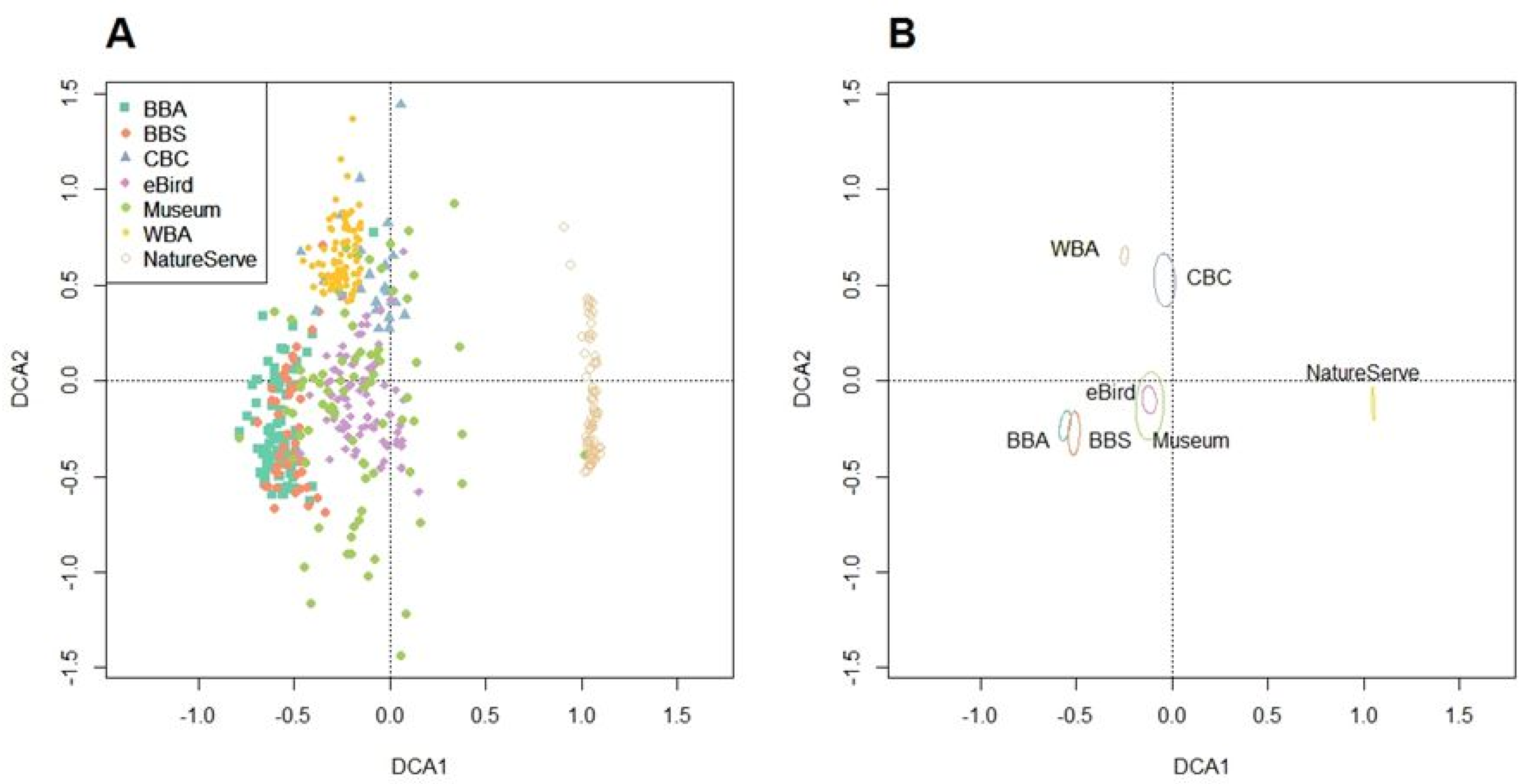
| OBBA | BBS | NatureServe | OWBA | CBC | eBird | Museum | |
|---|---|---|---|---|---|---|---|
| OBBA | 1 | 0.05 | 0.16 | 0.47 * | −0.1 | 0.15 | 0.11 |
| BBS | 1 | 0.48 * | 0.13 | 0.39 | 0.17 | 0.07 | |
| NatureServe | 1 | 0.17 | 0.09 | 0.03 | −0.02 | ||
| WBA | 1 | −0.05 | 0.23 * | 0.14 | |||
| CBC | 1 | 0.74 * | 0.44 * | ||||
| eBird | 1 | 0.54 * | |||||
| Museum | 1 |
| County | OBBA | BBS | eBird | WBA | NatureServe | CBC | Museum | Total Sp. |
|---|---|---|---|---|---|---|---|---|
| Adair | 8 | 12 | 4 | 12 | 4 | 24 | ||
| Alfalfa | 5 | 5 | 28 | 7 | 10 | 13 | 6 | 32 |
| Atoka | 8 | 6 | 16 | 9 | 11 | 8 | 24 | |
| Beaver | 9 | 7 | 23 | 7 | 9 | 9 | 26 | |
| Beckham | 6 | 4 | 10 | 4 | 10 | 6 | 16 | |
| Blaine | 7 | 4 | 15 | 7 | 11 | 3 | 7 | 24 |
| Bryan | 7 | 15 | 5 | 11 | 7 | 23 | ||
| Caddo | 5 | 7 | 10 | 3 | 11 | 5 | 20 | |
| Canadian | 5 | 23 | 5 | 11 | 5 | 29 | ||
| Carter | 6 | 6 | 13 | 4 | 12 | 6 | 23 | |
| Cherokee | 9 | 10 | 19 | 5 | 12 | 9 | 23 | |
| Choctaw | 3 | 6 | 11 | 4 | 11 | 3 | 21 | |
| Cimarron | 10 | 8 | 22 | 8 | 9 | 10 | 10 | 27 |
| Cleveland | 6 | 8 | 29 | 5 | 12 | 15 | 6 | 38 |
| Coal | 3 | 8 | 5 | 6 | 11 | 3 | 21 | |
| Comanche | 5 | 5 | 25 | 5 | 10 | 13 | 5 | 29 |
| Cotton | 5 | 7 | 11 | 6 | 10 | 5 | 22 | |
| Craig | 7 | 8 | 8 | 8 | 10 | 7 | 19 | |
| Creek | 7 | 7 | 11 | 4 | 10 | 7 | 20 | |
| Custer | 5 | 5 | 17 | 5 | 10 | 15 | 5 | 25 |
| Delaware | 8 | 7 | 13 | 5 | 12 | 8 | 8 | 24 |
| Dewey | 4 | 13 | 3 | 10 | 4 | 20 | ||
| Ellis | 6 | 13 | 4 | 10 | 12 | 6 | 23 | |
| Garfield | 5 | 7 | 22 | 5 | 12 | 5 | 27 | |
| Garvin | 7 | 8 | 4 | 12 | 7 | 20 | ||
| Grady | 4 | 13 | 4 | 11 | 4 | 20 | ||
| Grant | 5 | 4 | 10 | 5 | 12 | 5 | 20 | |
| Greer | 4 | 5 | 11 | 2 | 11 | 4 | 19 | |
| Harmon | 7 | 5 | 8 | 5 | 10 | 7 | 17 | |
| Harper | 8 | 7 | 15 | 4 | 10 | 8 | 20 | |
| Haskell | 8 | 6 | 7 | 12 | 8 | 20 | ||
| Hughes | 7 | 7 | 8 | 5 | 11 | 7 | 20 | |
| Jackson | 3 | 15 | 5 | 11 | 4 | 3 | 20 | |
| Jefferson | 3 | 12 | 7 | 11 | 3 | 21 | ||
| Johnston | 7 | 6 | 24 | 6 | 10 | 14 | 7 | 28 |
| Kay | 8 | 13 | 8 | 11 | 8 | 22 | ||
| Kingfisher | 5 | 5 | 8 | 3 | 11 | 5 | 18 | |
| Kiowa | 4 | 4 | 19 | 5 | 10 | 4 | 25 | |
| Latimer | 5 | 9 | 2 | 12 | 5 | 22 | ||
| LeFlore | 10 | 13 | 17 | 6 | 13 | 10 | 25 | |
| Lincoln | 5 | 7 | 2 | 11 | 5 | 19 | ||
| Logan | 6 | 10 | 4 | 12 | 6 | 6 | 22 | |
| Love | 5 | 11 | 2 | 12 | 5 | 20 | ||
| Major | 5 | 5 | 6 | 3 | 10 | 5 | 18 | |
| Marshall | 6 | 10 | 6 | 10 | 6 | 21 | ||
| Mayes | 6 | 13 | 6 | 10 | 6 | 22 | ||
| McClain | 4 | 18 | 3 | 12 | 4 | 26 | ||
| McCurtain | 9 | 12 | 37 | 8 | 13 | 10 | 9 | 37 |
| McIntosh | 8 | 9 | 4 | 11 | 4 | 8 | 21 | |
| Murray | 3 | 11 | 4 | 11 | 1 | 3 | 23 | |
| Muskogee | 7 | 5 | 13 | 4 | 12 | 7 | 21 | |
| Noble | 5 | 17 | 3 | 11 | 14 | 5 | 24 | |
| Nowata | 5 | 13 | 5 | 10 | 5 | 21 | ||
| Okfuskee | 8 | 7 | 4 | 11 | 8 | 19 | ||
| Oklahoma | 6 | 6 | 24 | 5 | 13 | 16 | 6 | 30 |
| Okmulgee | 7 | 7 | 12 | 7 | 11 | 7 | 20 | |
| Osage | 9 | 9 | 26 | 9 | 11 | 14 | 9 | 27 |
| Ottawa | 7 | 10 | 12 | 5 | 11 | 7 | 23 | |
| Pawnee | 4 | 17 | 4 | 11 | 4 | 23 | ||
| Payne | 6 | 24 | 2 | 11 | 12 | 6 | 27 | |
| Pittsburg | 9 | 11 | 15 | 6 | 11 | 9 | 26 | |
| Pontotoc | 5 | 10 | 3 | 10 | 5 | 19 | ||
| Pottawatomie | 5 | 9 | 3 | 11 | 5 | 22 | ||
| Pushmataha | 9 | 7 | 8 | 5 | 12 | 9 | 22 | |
| Roger Mills | 5 | 5 | 15 | 4 | 10 | 5 | 21 | |
| Rogers | 9 | 6 | 20 | 6 | 10 | 12 | 9 | 26 |
| Seminole | 6 | 9 | 4 | 10 | 6 | 18 | ||
| Sequoyah | 8 | 18 | 6 | 12 | 10 | 8 | 25 | |
| Stephens | 4 | 5 | 8 | 6 | 11 | 12 | 4 | 22 |
| Texas | 6 | 7 | 17 | 5 | 9 | 6 | 22 | |
| Tillman | 4 | 20 | 6 | 10 | 4 | 26 | ||
| Tulsa | 5 | 8 | 28 | 6 | 10 | 13 | 5 | 31 |
| Wagoner | 6 | 16 | 4 | 11 | 10 | 6 | 23 | |
| Washington | 8 | 20 | 6 | 10 | 8 | 23 | ||
| Washita | 4 | 12 | 6 | 10 | 4 | 20 | ||
| Woods | 6 | 6 | 11 | 2 | 9 | 6 | 19 | |
| Woodward | 5 | 7 | 16 | 4 | 10 | 6 | 5 | 24 |
| OBBA_c | BBS_c | NatureServe_c | WBA_c | CBC_c | eBird_c | Museum_c | |
|---|---|---|---|---|---|---|---|
| OBBA | 0.64 * | 0.15 | 0.11 | 0.31 * | −0.19 | 0.08 | 0.65 * |
| BBS | 0.23 | 0.56 * | 0.37 * | 0.30 * | 0.25 | 0.09 | 0.27 |
| NatureServe | 0.22 | 0.40 * | 0.63 * | 0.16 | 0.01 | 0.03 | 0.15 |
| WBA | 0.14 | −0.06 | 0.06 | 0.48 * | −0.03 | 0.22 | 0.18 |
| CBC | 0.01 | 0.17 | −0.08 | 0.25 | 0.91 * | 0.76 * | 0.05 |
| eBird | 0.11 | 0.21 | −0.03 | 0.27 * | 0.57 * | 0.92 * | 0.17 |
| Museum | 0.11 | 0.19 | −0.13 | 0.27 * | 0.31 | 0.52 * | 0.15 |
Publisher’s Note: MDPI stays neutral with regard to jurisdictional claims in published maps and institutional affiliations. |
© 2021 by the authors. Licensee MDPI, Basel, Switzerland. This article is an open access article distributed under the terms and conditions of the Creative Commons Attribution (CC BY) license (https://creativecommons.org/licenses/by/4.0/).
Share and Cite
Butler, C.J.; King, C.; Reinking, D.L. Do Citizen Science Methods Identify Regions of High Avian Biodiversity? Diversity 2021, 13, 656. https://doi.org/10.3390/d13120656
Butler CJ, King C, Reinking DL. Do Citizen Science Methods Identify Regions of High Avian Biodiversity? Diversity. 2021; 13(12):656. https://doi.org/10.3390/d13120656
Chicago/Turabian StyleButler, Christopher J., Chad King, and Dan L. Reinking. 2021. "Do Citizen Science Methods Identify Regions of High Avian Biodiversity?" Diversity 13, no. 12: 656. https://doi.org/10.3390/d13120656
APA StyleButler, C. J., King, C., & Reinking, D. L. (2021). Do Citizen Science Methods Identify Regions of High Avian Biodiversity? Diversity, 13(12), 656. https://doi.org/10.3390/d13120656