New Indicators of Spatial Chaos in the Context of the Need for Retrofitting Suburbs


Abstract

1. Introduction
- physiognomic aspect (aesthetic, visual, architectural, compositional)—scale of the place (object, building, farm, place, street, nearest surroundings);
- morphological aspect (structural, local, urban, planning, landscape)—scale of the area (village, town, registration precinct, city, municipality, urban neighbourhood);
- functional aspect (regional, socioeconomic)—scale of the region (poviat or group of poviats, voivodship, historical lands, country).
2. The Need of Rethinking Urban Sprawl—Review of Literature
2.1. Retrofitting of Suburbs by Increasing Their Compactness
2.2. Indicators of Suburban Spatial Chaos in the Context of Compactness
2.2.1. Street Connectivity
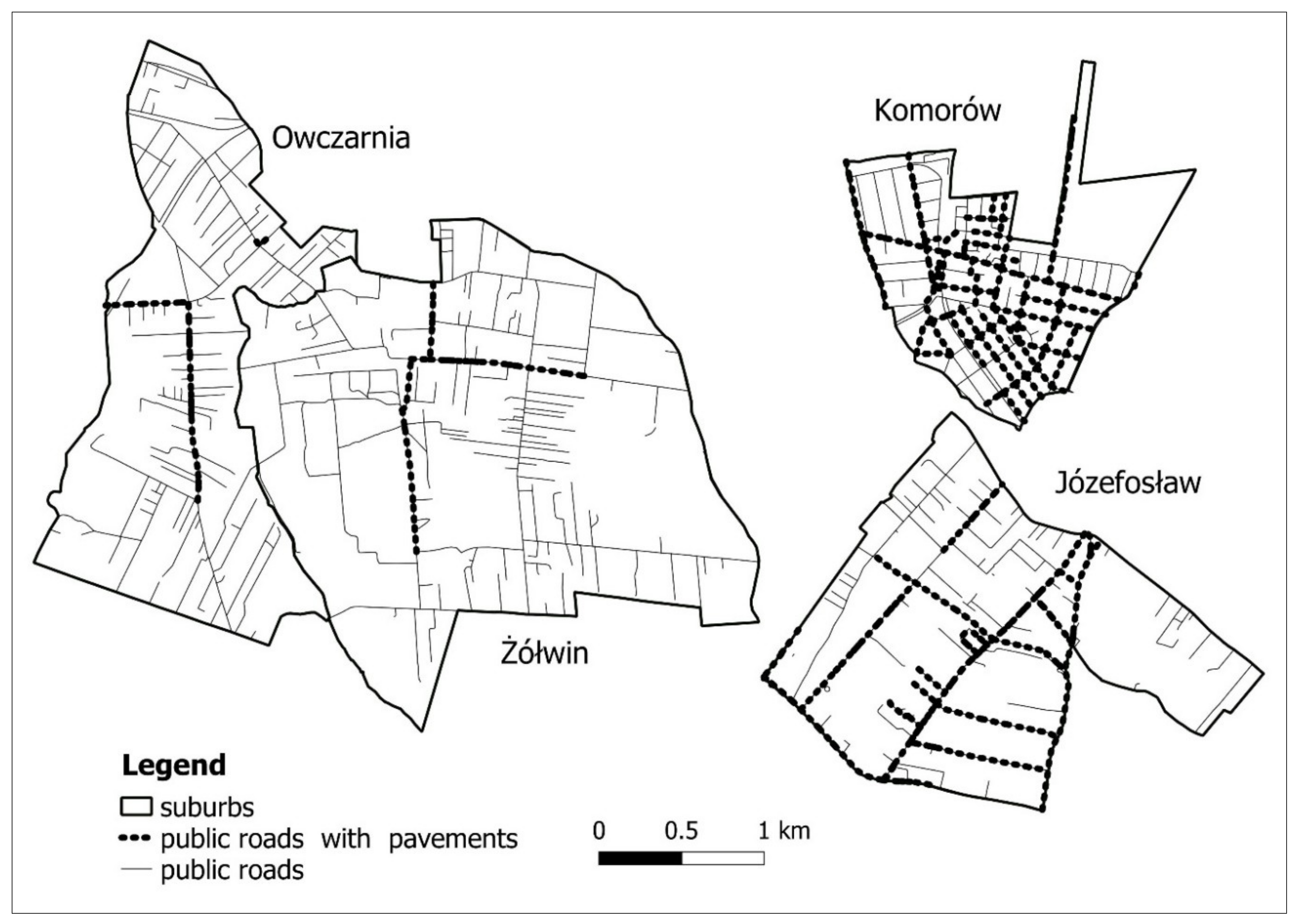
2.2.2. Pedestrian Infrastructure
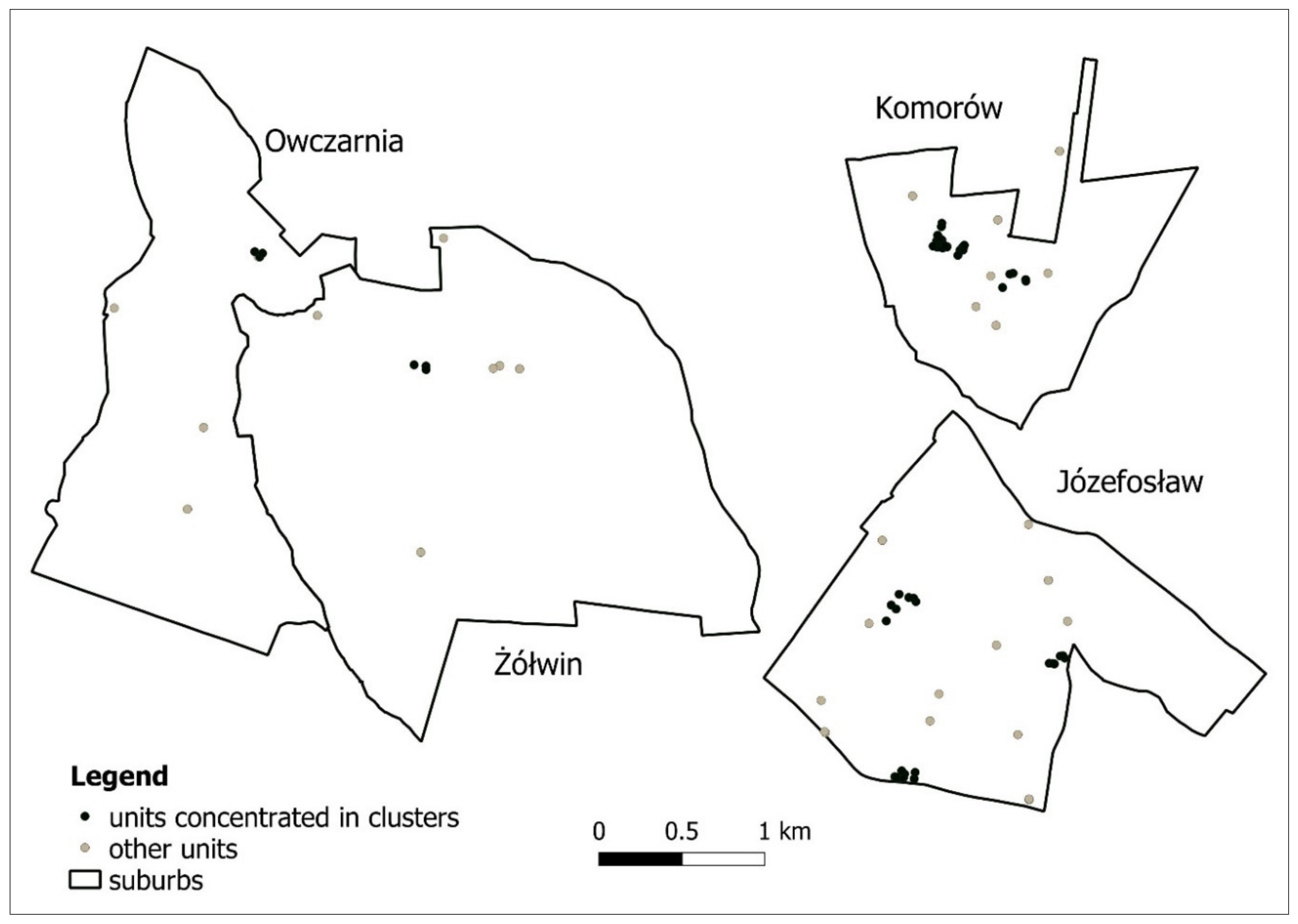
Centrality/Nuclearity
2.2.3. Proximity to Public Objects and Services
2.2.4. Location of Main Public Open Space
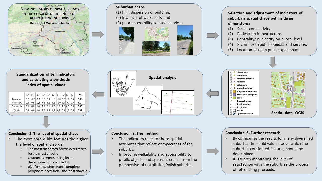
3. Materials and Methods
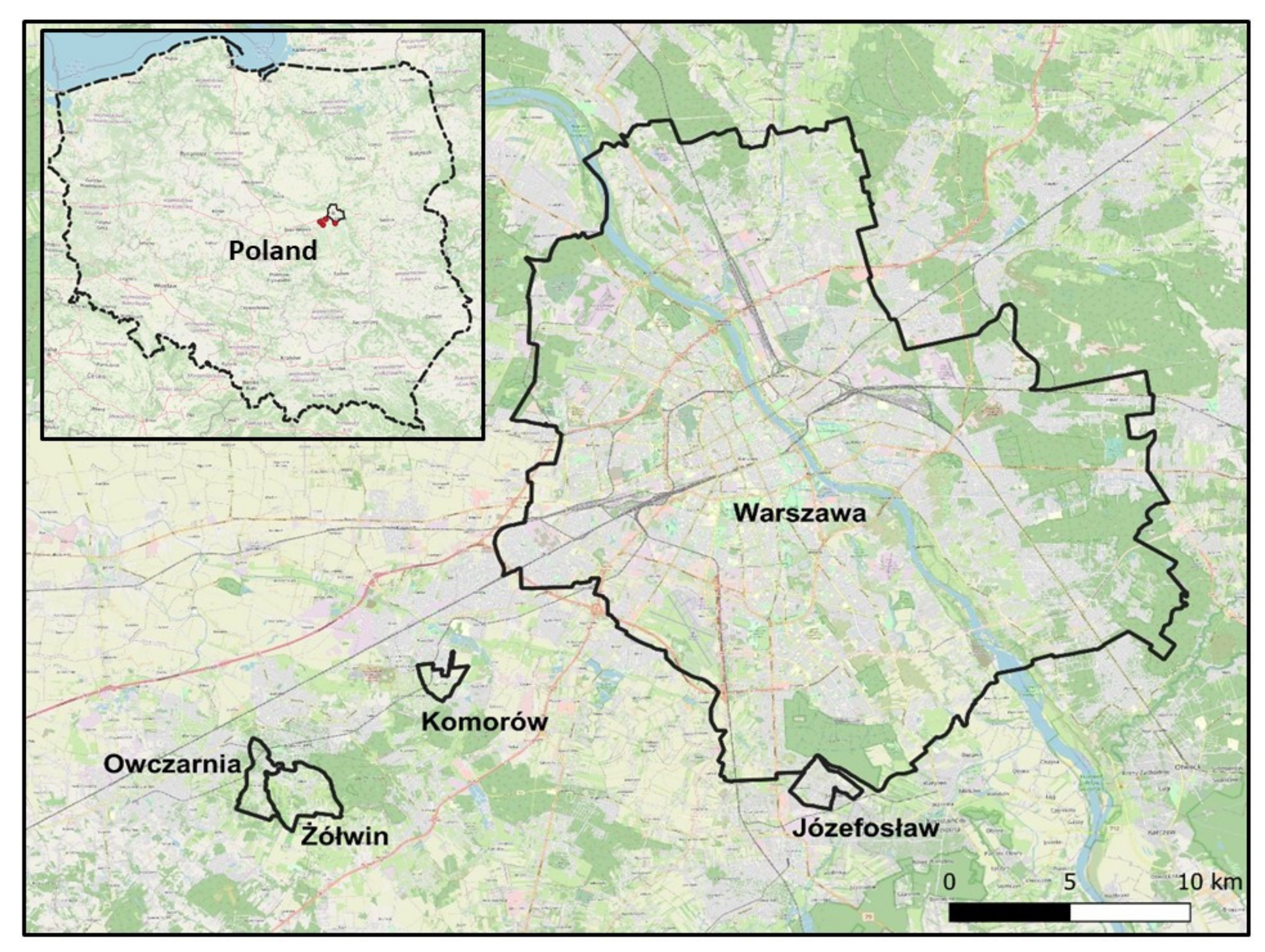
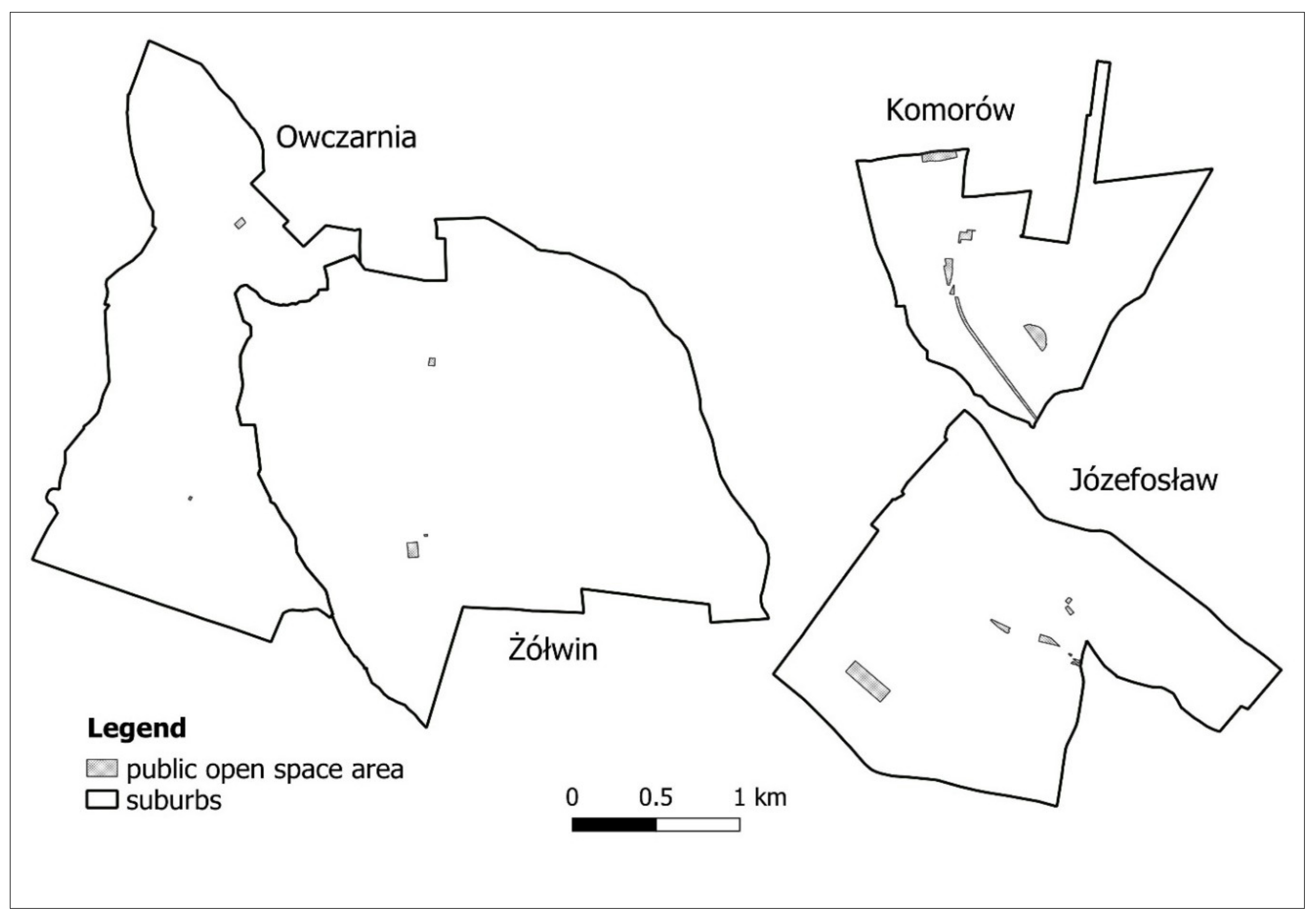
3.1. Study Area
- Józefosław: a typical urban village adjacent to Warsaw, populated in 2020 by 10,497 inhabitants,2 diversified in terms of type of buildings and type of housing estates, spontaneously developed along three main roads parallel to each other, dominated by gated communities and private cul-de-sacs. There is no local centre there and the pedestrian infrastructure and recreational spaces are still insufficient. The village represents the peripheral accretion type of urban sprawl.
- Żółwin and Owczarnia: two adjacent to each other former rural villages, populated in 2019 by 1637 inhabitants in Żółwin and 1455 inhabitants in Owczarnia,3 characterized by dispersed development, poor road and pedestrian infrastructure, and poor access to retail and services. Street layout in Żółwin consists of four intersecting main roads and departing from them cul-de-sacs, and Owczarnia extends along one main road with perpendicular cul-de-sacs on both sides. The whole area of Żółwin resembles a patchwork of houses, fields, and wasteland in between, while Owczarnia is an example of ribbon sprawl. Owczarnia represents linear development, while Żółwin the most dispersed type of urban sprawl.
- Komorów estate: a settlement modelled on a garden city, populated on 1st June 2020 by 3569 inhabitants,4 dominated by individual detached houses, whole settlement developed on a grid street layout around a local centre, equipped with pedestrian infrastructure and recreational spaces. Komorów estate is an example of sustainable suburbs.
3.2. Methods of Obtaining Data
3.3. Synthetic Indicator of Spatial Chaos
- —the arithmetic mean value of the j-th indicator;
- —the value of standard deviation of the j-th indicator.
- n—the number of included indicators;
- —the standardized value of the j-th indicator of the i-th suburb:
- —the original value of the j-th indicator of the i-th suburb;
- —the arithmetic mean value of the j-th indicator;
- —the value of standard deviation of the j-th indicator.
- —the original value of the j-th indicator of the i-th suburb;
- —the minimum value in the set of values of a given indicator;
- —the maximum value in the set of values of a given indicator.
- n—the number of included indicators;
- —the normalized value of the j-th indicator of the i-th suburb;
- —the weighting factor of the j-th indicator, assuming that all weighting factors add up to 1.
- Calculating the entropy of the j-th indicator as follows:where:
- m—number of objects (suburbs);
- ;
- (when , make ).
- Calculating the entropy weight of the j-th indicator as follows:where:
- 0 ≤ ≤ 1 and .
4. Results
5. Conclusions and Discussion
Author Contributions
Funding
Conflicts of Interest
References
- Mantey, D. Żywiołowość Lokalizacji Osiedli Mieszkaniowych Na Terenach Wiejskich Obszaru Metropolitalnego Warszawy; Uniwersytet Warszawski, WGiSR: Warsaw, Poland, 2011. [Google Scholar]
- Chojnicki, Z. Współczesne problemy gospodarki przestrzennej. In Współczesne Problemy Geografii Społeczno-Ekonomicznej Polski; Chojnicki, Z., Czyż, T., Eds.; Wydawnictwo Naukowe UAM: Poznań, Poland, 1992; pp. 9–19. [Google Scholar]
- Kozłowski, L.; Bielska, B.; Brzezińska-Rawa, A.; Flanz, S.; Goszczyński, W.; Karwacki, A.; Knieć, W.; Koziński, G.; Kurowska, I.; Marcysiak, T.; et al. Ład Przestrzenny w Województwie Kujawsko-Pomorskim. Diagnoza z Założeniami Programu Jego Kształtowania; UMK in Toruń, Wydział Nauk o Ziemi, Urząd Marszałkowski Województwa Kujawsko-Pomorskiego in Toruń Departament Rozwoju Regionalnego: Toruń, Poland, 2016. [Google Scholar]
- Kopeć, A. Poziom ładu przestrzennego w podmiejskiej strefie aglomeracji Trójmiasta. Kategoria społeczna i legislacja. In Gospodarka Przestrzenna Społeczeństwu; Ratajczak, W., Stachowiak, K., Eds.; Bogucki Wydawnictwo Naukowe: Poznań, Poland, 2010; pp. 123–143. [Google Scholar]
- Falkowski, J. Ład przestrzenny w planowaniu i zagospodarowaniu obszarów wiejskich na przykładzie województwa kujawsko-pomorskiego. Studia Obsz. Wiej. 2018, 50, 25–47. [Google Scholar] [CrossRef]
- Śleszyński, P. Wskaźniki Zagospodarowania i Ładu Przestrzennego w Gminach; Biuletyn KPZK PA: Warsaw, Poland, 2013; Volume 252. [Google Scholar]
- Ślęzak, T.; Zioło, Z. Społeczno-Gospod. I Przyr. Asp. Ładu Przestrz; Biuletyn KPZK PAN: Warsaw, Poland, 2003; Volume 205. [Google Scholar]
- Wdowicka, M.; Mierzejewska, L. Chaos w zagospodarowaniu przestrzennym stref podmiejskich jako efekt braku zintegrowanego systemu planowania (na przykładzie strefy podmiejskiej Poznania). Probl. Rozw. Miast 2012, 1, 40–52. [Google Scholar]
- Gorzelak, G. Szkic o wymiarach ładu przestrzennego. In Społeczno-Gospodarcze i Przyrodnicze Aspekty Ładu Przestrzennego; Ślęzak, T., Zioło, Z., Eds.; Biuletyn KPZK PAN: Warsaw, Poland, 2003; Volume 205, pp. 55–69. [Google Scholar]
- Śleszyński, P.; Markowski, T.; Kowalewski, A. Studia nad Chaosem Przestrzennym. Tom 3. Synteza. Uwarunkowania, Skutki i Propozycje Naprawy Chaosu Przestrzennego; Studia KPZK PAN: Warsaw, Poland, 2018; Volume 182. [Google Scholar]
- Zioło, Z. Przestrzeń geograficzna jako miejsce realizacji idei ładu przestrzennego. In Społeczno-Gospodarcze i Przyrodnicze Aspekty Ładu Przestrzennego; Ślęzak, T., Zioło, Z., Eds.; Biuletyn KPZK PAN: Warsaw, Poland, 2003; Volume 205, pp. 25–43. [Google Scholar]
- Borys, T. Wskaźniki Zrównoważonego Rozwoju; Wyd. Ekonomia i Środowisko: Warsaw-Białystok, Poland, 2005. [Google Scholar]
- Śleszyński, P. Propozycja kompleksowej koncepcji wskaźników zagospodarowania i ładu przestrzennego. In Wskaźniki Zagospodarowania i Ładu Przestrzennego w Gminach; Śleszyński, P., Ed.; Biuletyn KPZK PAN: Warsaw, Poland, 2013; Volume 252, pp. 176–231. [Google Scholar]
- Affek, A. Propozycje wskaźników środowiskowych do oceny zagospodarowania i ładu przestrzennego w gminach. In Wskaźniki Zagospodarowania i Ładu Przestrzennego w Gminach; Śleszyński, P., Ed.; Biuletyn KPZK PAN: Warsaw, Poland, 2013; Volume 252, pp. 51–86. [Google Scholar]
- Rosik, P.; Ciechański, A. Propozycje wskaźników infrastruktury transportu drogowego i kolejowego. In Wskaźniki Zagospodarowania i Ładu Przestrzennego w Gminach; Śleszyński, P., Ed.; Biuletyn KPZK PAN: Warsaw, Poland, 2013; Volume 252, pp. 110–131. [Google Scholar]
- Górczyńska, M. Wskaźniki zagospodarowania i ładu przestrzennego w miastach i na obszarach silnie zurbanizowanych. In Wskaźniki Zagospodarowania i Ładu Przestrzennego w Gminach; Śleszyński, P., Ed.; Biuletyn KPZK PAN: Warsaw, Poland, 2013; Volume 252, pp. 87–109. [Google Scholar]
- Galster, G.; Hanson, R.; Ratcliffe, M.R.; Wolman, H.; Coleman, S.; Freihage, J. Wrestling Sprawl to the Ground: Defining and Measuring an Elusive Concept. Hous. Policy Debate 2001, 12, 681–717. [Google Scholar] [CrossRef]
- Sudra, P. Zastosowanie wskaźników koncentracji przestrzennej w badaniu procesów urban sprawl. Przegląd Geogr. 2016, 88, 247–272. [Google Scholar] [CrossRef]
- Stanilov, K.; Sýkora, L. Confronting Suburbanization Urban Decentralization in Postsocialist Central and Eastern Europe; John Wiley & Sons: Chichester, UK, 2014. [Google Scholar]
- Tsenkova, S.; Nedović-Budić, Z. The Urban. Mosaic of Post-Socialist Europe: Space, Institutions and Policy; Physica-Verlag: New York, NY, USA, 2006. [Google Scholar]
- Sykora, L.; Ourednicek, M. Sprawling Post-Communist Metropolis: Commercial and Residential Suburbanisation in Prague and Brno, the Czech Republic. Employment Deconcentration in European Metropolitan Areas: Market. Forces versus Planning Regulations; Dijst, M., Razin, E., Vazquez, C., Eds.; Springer: Dordrecht, The Netherlands, 2007; pp. 209–234. [Google Scholar]
- Pichler-Milanović, N.; Gutry-Korycka, M.; Rink, D. Sprawl in the Post-Socialist City: The Changing Economic and Institutional Context of Central and Eastern European Cities; Couch, C., Petschel-Held, G., Leontidou, L., Eds.; Urban Sprawl in Europe, Landscape, Land-Use Change and Policy; Wiley-Blackwell: Hoboken, NY, USA, 2007; pp. 102–135. [Google Scholar]
- Tammaru, T.; Leetmaa, K.; Silm, S.; Ahas, R. Temporal and Spatial Dynamics of the New Residential Areas Around Tallinn. Eur. Plan. Stud. 2009, 17, 423–439. [Google Scholar] [CrossRef]
- Hirt, S. Iron Curtains: Gates, Suburbs and Privatization of Space in the Post-Socialist City; Wiley-Blackwell: Oxford, UK; Malden, MA, USA, 2012. [Google Scholar]
- Dinić, M.; Mitković, P. Suburban design: From “bedroom communities” to sustainable neighborhoods. Geod. Vestn. 2016, 60, 98–113. [Google Scholar] [CrossRef]
- Taubenböck, H.; Gerten, K.; Rusche, K.; Siedentop, S.; Wurm, M. Patterns of Eastern European urbanisation in the mirror of Western trends—Convergent, unique or hybrid? Environ. Plan. B Urban Anal. City Sci. 2019, 46, 1206–1225. [Google Scholar] [CrossRef]
- Springer, F. Wanna z Kolumnadą; Wyd. Czarne: Wołowiec, Poland, 2013. [Google Scholar]
- Zuziak, Z. Strefa podmiejska w architekturze miasta. W stronę nowej architektoniki regionu miejskiego. In Problem Suburbanizacji; Lorens, P., Ed.; Urbanista: Warsaw, Poland, 2005; pp. 17–32. [Google Scholar]
- Chmielewski, J.M. Problemy rozpraszania się zabudowy na obszarze metropolitalnym Warszawy. In Problem Suburbanizacji; Lorens, P., Ed.; Urbanista: Warsaw, Poland, 2005; pp. 52–62. [Google Scholar]
- Solarek, K. Struktura Przestrzenna Strefy Podmiejskiej Warszawy: Determinanty Współczesnych Przekształceń; Politechnika Warszawska: Warsaw, Poland, 2013. [Google Scholar]
- Zimnicka, A.; Czernik, L. Kształtowanie Przestrzeni Wsi Podmiejskiej Raport z Badań Obszaru Oddziaływania Miasta Szczecin; Hogben: Szczecin, Poland, 2007. [Google Scholar]
- Gordon, P.; Richardson, H.W. Are compact cities a desirable planning goal? J. Am. Plan. Assoc. 1997, 63, 95–106. [Google Scholar] [CrossRef]
- Ewing, R. Is Los Angeles-style sprawl desirable? J. Am. Plan. Assoc. 1997, 63, 107–126. [Google Scholar] [CrossRef]
- Ahlfedlt, G.; Pietrostefani, E. The Effects of Compact Urban form: A Qualitative and Quantitative Evidence Review; Coalition for Urban Transitions: London, UK; Washington, DC, USA, 2017; Available online: http://newclimateeconomy.net/content/cities-working-papers (accessed on 9 July 2020).
- Fulton, W. The New Urbanism: Hope or Hype for American Communities; Lincoln Institute of Land Policy: Cambridge, MA, USA, 1996. [Google Scholar]
- Polit, A. Idea miasta zwartego a rzeczywistość. Czas. Tech. Archit. 2010, 14, 85–91. [Google Scholar]
- Mierzejewska, L. Miasto zwarte, rozproszone, zrównoważone. Studia Miej. 2015, 19, 9–22. [Google Scholar]
- Dunham-Jones, H.; Willianson, J. Retrofitting Suburbia: Urban. Design Solutions for Redesigning Suburbs; John Wiley & Sons: Hoboken, NJ, USA, 2009. [Google Scholar]
- Marique, A.F.; Reiter, S. Retrofitting the Suburbs: Insulation, density, urban form and location. Environ. Manag. Sustain. Dev. 2014, 3, 138–153. [Google Scholar] [CrossRef]
- Talen, E. Retrofitting Sprawl: Addressing Seventy Years of Failed Urban Form; University of Georgia Press: Athens, GA, USA, 2015. [Google Scholar]
- Tachieva, G. Sprawl Repair Manual; Island Press: Washington, DC, USA, 2010. [Google Scholar]
- Fishman, R. Longer view: The fifth migration. J. Am. Plan. Assoc. 2005, 71, 357–366. [Google Scholar] [CrossRef]
- ODPM (Office of the Deputy Prime Minister). Sustainable Communities: Building for the Future; ODPM: London, UK, 2003.
- Stanilov, K. The Post-Socialist City: Urban form and Space Transformations in Central and Eastern Europe after Socialism; Springer: Dordrecht, The Netherlands, 2007. [Google Scholar]
- Tsai, Y.-H. Quantifying Urban Form: Compactness versus ‘Sprawl’. Urban. Stud. 2005, 42, 141–161. [Google Scholar] [CrossRef]
- Trova, V. Measures of Street Connectivity: Spatialist Lines (MoSC). In Accessibility Instruments for Planning Practice; Hull, A., Silva, C., Bertolini, L., Eds.; COST Office: Porto, Portugal, 2012; pp. 103–109. [Google Scholar]
- Ozbil, A.; Peponis, J.; Stone, B. Understanding the link between street connectivity, land use and pedestrian flows. Urban. Des. Int. 2011, 16, 125–141. [Google Scholar] [CrossRef]
- Barthelemy, M.; Flammini, A. Modeling Urban Street Patterns. Phys. Rev. Lett. 2008, 100, 138702. [Google Scholar] [CrossRef]
- Cardillo, A.; Scellato, S.; Latora, V.; Porta, S. Structural properties of planar graphs of urban street patterns. Phys. Rev. E 2006, 73. [Google Scholar] [CrossRef]
- Lin, J.; Ban, Y. Complex network topology of transportation systems. Transp. Rev. 2013, 33, 658–685. [Google Scholar] [CrossRef]
- Marshall, S.; Gil, J.; Kropf, K.; Tomko, M.; Figueiredo, L. Street network studies: From networks to models and their representations. Netw. Spat. Econ. 2018, 15. [Google Scholar] [CrossRef]
- Parks, J.R.; Schofer, J.L. Characterizing neighborhood pedestrian environments with secondary data. Transp. Res. Part. D Transp. Environ. 2006, 11, 250–263. [Google Scholar] [CrossRef]
- Galanis, A.; Eliou, N. Evaluation of the pedestrian infrastructure using walkability indicators. Wseas Trans. Environ. Dev. 2011, 12, 385–394. [Google Scholar]
- Replogle, M. Computer transportation models for land use regulation and master planning in Montgomery County, MD. Transp. Res. Rec. 1990, 1262, 91–100. [Google Scholar]
- Razin, E.; Dijst, M.; Vázquez, C. Employment Deconcentration in European Metropolitan Areas: Market Forces versus Planning Regulations; Springer: Dordrecht, Germany, 2007. [Google Scholar]
- Anas, A.; Arnott, R.; Small, K.A. Urban Spatial Structure. J. Econ. Lit. 1998, 36, 1426–1464. [Google Scholar]
- Oldenburg, R. The Great Good Place: Cafes, Coffee Shops, Bookstores, Bars, Hair Salons, and Other Hangouts at the Heart of a Community; Marlow & Co.: New York, NY, USA, 1999. [Google Scholar]
- Boulange, C.; Pettit, C.; Giles-Corti, B. The Walkability Planning Support System: An Evidence-Based Tool to Design Healthy Communities. In Planning Support Science for Smarter Urban Futures; Geertman, S., Allan, A., Pettit, C., Stillwell, J., Eds.; Springer International Publishing: Cham, Switzerland, 2017; pp. 153–166. [Google Scholar]
- Glaeser, E.L. Agglomeration Economics; The University of Chicago Press: Chicago, IL, USA, 2010. [Google Scholar]
- Bajwoluk, T. Centres in suburban zones—The form and accessibility. Czas. Tech. Archit. 2015, 12-A, 241–257. [Google Scholar]
- Vaughan, L.; Emma Jones, C.; Griffiths, S.; Haklay, M. The spatial signature of suburban town centres. J. Space Syntax 2010, 1, 77–91. [Google Scholar]
- Talen, E.; Koschinsky, J. The walkable neighborhood: A literature review. Int. J. Sustain. Land Use Urban. Plan. 2013, 1, 42–63. [Google Scholar] [CrossRef]
- Roberto, E. The Spatial Proximity and Connectivity (SPC) Method for Measuring and Analyzing Residential Segregation. Sociol. Methodol. 2018, 48, 182–224. [Google Scholar] [CrossRef]
- MacEachren, A.M. Travel time as the basis of cognitive distance. Prof. Geogr. 1980, 32, 30–36. [Google Scholar] [CrossRef]
- Kellett, J.; Rofe, M.W. Creating Active Communities: How can Open and Public Spaces in Urban and Suburban Environments Support Active Living? A Literature Review. Report by the Institute for Sustainable Systems and Technologies; University of South Australia to SA Active Living Coalition: Adelaide, SA, Australia, 2009; Available online: https://www.healthyactivebydesign.com.au/images/uploads/Creating_Active_Communities_electronic_FINAL.pdf (accessed on 8 July 2020).
- Cohen, D.; McKenzie, T.; Sehgal, A.; Williamson, S.; Golinelli, D.; Lurie, N. Contribution of public parks to physical activity. Am. J. Public Health 2007, 97/3, 509–514. [Google Scholar] [CrossRef]
- Swanwick, C.; Dunnett, N.; Woolley, H. Nature, Role and Value of Green Space in Towns and Cities: An Overview. Built Environ. 2003, 29, 94–106. [Google Scholar] [CrossRef]
- Tilt, J.H. Walking Trips to Parks: Exploring Demographic, Environmental Factors, and Preferences for Adults with Children in the Household. Prev. Med. 2010, 50, 69–73. [Google Scholar] [CrossRef] [PubMed]
- Walker, C. The Public Value of Urban Parks. In Beyond Recreation: A Broader View of Urban Parks; The Urban Institute: Washington, DC, USA, 2004; Available online: https://www.wallacefoundation.org/knowledge-center/Documents/The-Public-Value-of-Urban-Parks.pdf (accessed on 9 July 2020).
- Duany, A.; Plater-Zyberk, E.; Speck, J. Suburban Nation: The Rise of Sprawl and the Decline of the American Dream; North Point Press: New York, NY, USA, 2000. [Google Scholar]
- Chiesura, A. The Role of Urban Parks for the Sustainable City. Landsc. Urban. Plan. 2004, 68, 129–138. [Google Scholar] [CrossRef]
- Frank, L.; Andersen, M.; Schmid, T. Obesity relationships with community design, physical activity, and time spent in cars. Am. J. Prev. Med. 2004, 27, 87–96. [Google Scholar] [CrossRef] [PubMed]
- Mantey, D. Wzorzec Miejskiej Przestrzeni Publicznej w Konfrontacji z Podmiejską Rzeczywistością; Wydawnictwa Uniwersytetu Warszawskiego: Warsaw, Poland, 2019. [Google Scholar]
- Dąbrowska-Milewska, G. Standardy urbanistyczne dla terenów mieszkaniowych: Wybrane zagadnienia. Archit. Artibus 2010, 2, 17–31. [Google Scholar]
- Thompson, S. Design for Open Space. Fact Sheet; Your Development: Melbourne, VIC, Australia, 2008. Available online: http://yourdevelopment.org/factsheet/view/id/72 (accessed on 14 April 2009).
- Perkal, J. O wskaźnikach antropologicznych. Przegląd Antropol. 1953, 19, 210–221. [Google Scholar]
- Czyż, T. Metoda wskaźnikowa w geografii społeczno-ekonomicznej. Rozw. Reg. I Polityka Reg. 2016, 34, 9–19. [Google Scholar]
- Kukuła, K. Metoda unitaryzacji zerowanej (Zero Unitarisation Method); PWN: Warsaw, Poland, 2000. [Google Scholar]
- Tomal, M. Moving towards a Smarter Housing Market: The Example of Poland. Sustainability 2020, 12, 683. [Google Scholar] [CrossRef]
- Wand, Q.; Mao, Z.; Xian, L.; Liang, Z. A study on the coupling coordination between tourism and the low-carbon city. Asia Pac. J. Tour. Res. 2019, 24, 550–562. [Google Scholar] [CrossRef]
- Whyte, W.H. The Social Life of Small Urban Spaces; The Municipal Arts Society: New York, NY, USA, 1980. [Google Scholar]
- Newman, M. The Compact City Fallacy. J. Plan. Educ. Res. 2005, 25, 11–26. [Google Scholar] [CrossRef]
- Abass, Z.I.; Andrews, F.; Tucker, R. Socializing in the suburbs: Relationships between neighbourhood design and social interaction in low-density housing contexts. J. Urban. Des. 2020, 25, 108–133. [Google Scholar] [CrossRef]
| 1 | Act regulating issues related to planning of Polish space and introducing rules for its development; setting out the type, scope, and procedures for enacting planning documents at different levels of administration; and defining new categories of space, e.g., area of public space, and new conceptual categories, e.g., spatial order. |
| 2 | Data retrieved from the website of the municipality of Piaseczno: http://bip.piaseczno.eu/artykul/55/4150/demografia. |
| 3 | Both data sources retrieved from the website of the municipality of Brwinów: https://bip.brwinow.pl/gmina-brwinow-w-liczbach. |
| 4 | Data obtained from the Citizens’ Affairs Department of the municipality of Michałowice. |
| 5 | The topographic database obtained for the WGSR UW from the Central Office of Geodesy and Cartography. |
| 6 | Poviat is the second-level unit of local government and administration in Poland between a municipality (local level) and a voivodeship (regional level). |
| 7 | DNSCAN—Density-based spatial clustering of applications with noise. It is a density-based clustering algorithm: given a set of points in some space, it groups together points that are closely packed together (points with many nearby neighbors). |
| 8 | Cul-de-sacs are dead-end streets among the category of “other” roads according to the topographic database. |
| 9 | The value of the indicator does not depend on whether the pavement is on one or both sides of the road. |
| 10 | Units of other than residential function: bars, restaurants, banks, cash machines, pharmacies, shops, schools, post offices, local community centres. |
| 11 | Cluster is a concentration of a minimum three units of other than residential function at a distance of not more than 100 m from each other. |
| 12 | Centre of gravity is a point determining the mass centre of geometry of surface objects. |
| 13 | It was assumed that the nearest grocery does not have to be within the studied suburb, it can be located in a neighbouring administrative unit. |
| 14 | The main public open space is the largest in size. |
| 15 | Node of activity is identified with a cluster. |


| Dimension of Spatial Chaos | Indicator of Spatial Chaos | Justification | Databases | Selected Layers. Functions and Methods of QGIS | |||
|---|---|---|---|---|---|---|---|
| Layers of Topographic Database | OSM | Google Maps and Street View | |||||
| 1. Street connectivity | spatial density of the public road network (main, collector and other) (m/1 km2) | spatial density of road network seems to be better indicator than demographic density because the latter is more dependent on the population density (population density does not affect walkability as much as the street density) | communication network, level3, administrative division units | - | data completion and verification | Layers: roads, division units. Line in polygon, Line intersections, Selection, Count points in polygon. | |
| the ratio of the number of four- or three-way intersections to the number of cul-de-sacs8 | large share of private cul-de-sacs is characteristic of Polish suburbs; cul-de-sacs decidedly limit the number of alternative walking routes | ||||||
| 2. Pedestrian infrastructure | the length of public roads equipped with a pavement9 in relation to the total length of three categories of roads: main, collector, and other (%) | pavements are basic element of pedestrian infrastructure encouraging suburbanites to walk, they are more important than street furniture and convenient pedestrian crossings | communication network | layer roads | data completion and verification | Layers: pavement roads, roads. Length. | |
| pedestrian design scale (indicator developed on the basis of the scale proposed by Replogle [54]): 0. no sidewalks, no safe roadsides and car restraints on most main and collective roads, or high proportion of dirt roads 1. no sidewalks, but safe roadsides and car restraints on most main and collective roads 2. sidewalks along selected main streets, in the case of most other roads, no safe roadsides and car restraints, or high proportion of dirt roads 3. sidewalks along selected main streets, in the case of most other roads, safe roadsides and car restraints 4. sidewalks along all main and some collector streets, no car restraints on most main and collective roads 5. sidewalks along all main and some collector streets, car restraints on most main and collective roads | pedestrian safety and comfort are important encouragement to walk, it is ensured by sidewalks, and in the case of their absence, by wide paved roadsides and car restraints, like speed bumps; width of pavements have been removed from the scale, because most pavements in Polish suburbs are relatively new, keep standards, and have a similar width | Not applicable | Not applicable | Not applicable | Not applicable | ||
| 3. Centrality/nuclearity on a local level | the ratio of units of other than residential function10 concentrated in clusters11 to the total number of such units (%) | concentration of various functions (other than residential) in a small area enhances using them all and by this improves profitability of retail and service points; it also animates social life | buildings | points layer | data completion | Layers: units, division units. DBSCAN clustering, Distance Matrix. | |
| average straight-line distance between all units of other than residential function (m) | close distances between individual units of different functions encourage people to walk and to explore the whole area of residence | ||||||
| 4. Proximity to public objects and services | straight-line distance from the centre of gravity12 of the suburb to the nearest public objects: primary school, church, bus stop/train station (m) | primary school, church, and bus stop/train station represent functions that are regularly used by all residents or specific age groups, and thus enable building social relations; when located within a suburb, they organize the whole space and flows of people | buildings | points layer | walking distance tool | Layers: centre, public points, buildings. Mean coordinates, Distance Matrix, Measure Line. | |
| the longest walking distance among all walking distances between a house located in the suburb and a nearest grocery13 (m) | objects used every day or very often should be as close as possible to the place of residence, preferably the distance should not exceed 300–500 m [60] | ||||||
| 5. Location of main public open space14 | the scale of location of the main local park (indicator developed on the basis of the scale proposed by Mantey [73]): 0. no local park within an administrative border of the suburb 1. space located somewhere “off the beaten track,” not visible from the nearest houses 2. space within a housing area, at some distance from nodes of activity15 (at least 500 m of walking distance), deprived of a safe pedestrian access 3. space within a housing area, at some distance from nodes of activity (at least 500 m of walking distance), but with a safe pedestrian access 4. space adjacent to a minor node of activity 5. space adjacent to the main node of activity | in Poland, municipalities have to pay high compensation if they want to purchase land for public space from private owners, this leads to the lack of local parks or their poor (random) location; as a result, the whole suburb is fragmented and the public space used not so frequently as it could be if its location is near the node of activity and the flow of pedestrians [81]. | Not applicable | Not applicable | Not applicable | Not applicable | |
| public open space area per 1000 residents in relation to the standard value of 2.83 ha/1000 people (%) (standard value according to Thompson [75]) | in the absence of urban standards in Poland, it will be possible to estimate how much the situation in individual suburbs differs from British standards | land use complexes | points layer, natural layer | data completion and verification | Layer: public space. Digitization of additional areas, Field calculator. | ||
| Coefficient of Variation (%) | |||||||||
| 29.3 | 111.1 | 80.2 | 40.0 | 30.9 | 34.0 | 30.0 | 44.8 | 53.8 | 64.9 |
| Weighting Factors | |||||||||
| 0.081 | 0.077 | 0.126 | 0.103 | 0.093 | 0.079 | 0.163 | 0.113 | 0.087 | 0.078 |
| Komorów | Józefosław | Owczarnia | Żółwin | ||
|---|---|---|---|---|---|
| Original values | |||||
| d | 13,968 | 7228 | 9265 | 7188 | |
| d | 13.09 | 1.9 | 1.32 | 1.61 | |
| d | 57 | 48 | 6 | 6 | |
| d | 5 | 4 | 2 | 2 | |
| d | 84 | 60 | 57 | 33 | |
| s | 303 | 853 | 917 | 749 | |
| s | 322 | 310 | 603 | 568 | |
| s | 830 | 1320 | 2900 | 2550 | |
| d | 5 | 3 | 2 | 1 | |
| d | 1.34 | 0.33 | 0.42 | 0.44 | |
| Synthetic Indicators of Spatial Chaos | |||||
| −1.445 | −0.069 | 0.693 | 0.821 | ||
| 0.000 | 0.056 | 0.089 | 0.093 | ||
| 0.001 | 0.047 | 0.090 | 0.093 | ||
© 2020 by the authors. Licensee MDPI, Basel, Switzerland. This article is an open access article distributed under the terms and conditions of the Creative Commons Attribution (CC BY) license (http://creativecommons.org/licenses/by/4.0/).
Share and Cite
Mantey, D.; Pokojski, W. New Indicators of Spatial Chaos in the Context of the Need for Retrofitting Suburbs. Land 2020, 9, 276. https://doi.org/10.3390/land9080276
Mantey D, Pokojski W. New Indicators of Spatial Chaos in the Context of the Need for Retrofitting Suburbs. Land. 2020; 9(8):276. https://doi.org/10.3390/land9080276
Chicago/Turabian StyleMantey, Dorota, and Wojciech Pokojski. 2020. "New Indicators of Spatial Chaos in the Context of the Need for Retrofitting Suburbs" Land 9, no. 8: 276. https://doi.org/10.3390/land9080276
APA StyleMantey, D., & Pokojski, W. (2020). New Indicators of Spatial Chaos in the Context of the Need for Retrofitting Suburbs. Land, 9(8), 276. https://doi.org/10.3390/land9080276