Letter

Bibliometric Analysis of Remote Sensing Research Trend in Crop Growth Monitoring: A Case Study in China

1
School of Geography, Geomatics and Planning, Jiangsu Normal University, Xuzhou 221116, China
2
School of Mechanics and Civil Engineering, China University of Mining and Technology, Xuzhou 221116, China
3
Ottawa Research and Development Centre, Agriculture and Agri-Food Canada, Ottawa, ON K1A0C6, Canada
*
Author to whom correspondence should be addressed.
Remote Sens. 2019, 11(7), 809; https://doi.org/10.3390/rs11070809
Submission received: 27 February 2019 / Revised: 29 March 2019 / Accepted: 1 April 2019 / Published: 4 April 2019
(This article belongs to the Special Issue Selected Papers from Agro-Geoinformatics 2018)

Abstract

:
Remote sensing of crop growth monitoring is an important technique to guide agricultural production. To gain a comprehensive understanding of historical progression and current status, and future trend of remote sensing researches and applications in the field of crop growth monitoring in China, a study was carried out based on the publications from the past 20 years by Chinese scholars. Using the knowledge mapping software CiteSpace, a quantitative and qualitative analysis of research development, current hotspots, and future directions of crop growth monitoring using remote sensing technology in China was conducted. Furthermore, the relationship between high-frequency keywords and the emerging hot topics were visually analyzed. The results revealed that Chinese researchers paid more attention on keywords such as “vegetation index”, “crop growth”, “winter wheat”, “leaf area index (LAI)”, and “model” in the field of crop growth monitoring, and “LAI” and “unmanned aerial vehicle (UAV)”, appeared increasingly in frontier research of this discipline. Overall, bibliometric results from this CiteSpace-aided study provide a quantitative visualization to enrich our understanding on the historical development, current status, and future trend of crop growth monitoring in China.

1. Introduction

Crop growth stage represent the morphological phase in the process of crop growth and development. The growth status is generally assessed by measuring the changes of leaf area, leaf color, leaf inclination angle, plant height, density, and stem diameter [1]. At different growth stages, crop growth rate and condition will be different [2]. Even at the same growth stage, the same crop type can exhibit different growth conditions due to differences in soil property, water supply, incoming radiation, temperature, pest/disease, and land management practices [3].
For a long time, information on crop growth condition was obtained from field scouting. Although this method can be accurate, it is time-consuming, costly, and limited in area of survey. In recent years, with the fast development of geospatial science and technology, remote sensing technologies were increasingly applied to monitoring crop growth conditions [2,4,5]. Remote sensing technologies have the advantages of imaging large areas repeatedly at a reasonable cost. With the fast development of UAV, remote sensing technology can capture crop growth in real time, which can help with crop yield forecast, pest and disease detection, and farm insurance payoff [6,7,8,9].
The remote sensing of crop growth monitoring can be considered as macroscopic, which offers timely and accurate information on crop growth condition and dynamics at a wide spatial and temporal scales, which is the basis for precision farming [2,3]. Remote sensing of crop growth monitoring in China began in the mid-1980s [10]. Starting from the 1990s, under the organization of central government departments (i.e., the Ministry of Science and Technology, the Ministry of Agriculture), national research institutes (i.e., the Chinese Academy of Sciences, the Chinese Academy of Agricultural Sciences), and other scientific research institutions, a series of key projects related to crop growth and yield estimation were carried out either collaboratively or independently. Crop growth monitoring gradually became the focus of agricultural remote sensing applications in China [11,12,13]. Remote sensing data with high temporal and spatial resolution provide continuous crop growth monitoring for entire growth cycles in the context of spatially explicit mapping. Ecologically and economically efficient agricultural management is highly dependent on detailed temporal and spatial knowledge of the processes affecting physiological crop development. Therefore, crop growth monitoring can provide an objective basis for precision agriculture and efficient management [2,5,14]. With the rapid development of the “3S” (Remote Sensing, Geographic Information System, and Global Positioning System) technologies, high-resolution satellite data, and big data analytics, remote sensing became an indispensable and important method for crop growth monitoring in China [6,15].
Worldwide, several research reviews on monitoring crop growth using remote sensing technology were published [1,3,16]; these kinds of reviews usually require the researchers to read a large amount of related literature, have a considerable understanding of the research in this field, and then further analyze and summarize the principles, contents, methods in the discipline. However, different individuals would have a different understanding of the significance of scientific research results. Even different conclusions can be drawn in the same research [17]. Moreover, the evaluation methods of literature are not consistent and dependent on the author’s knowledge structure. Therefore, a systematic review produced using a scientific literature measurement method can overcome the imperfection and non-objectivity defects. Through a more comprehensive literature collection, using a more scientific and objective literature evaluation standard, a systematic review can be conducted to obtain reliable conclusions on a particular research topic [18].
The CiteSpace software used in this study is an information visualization and statistical analysis tool designed for measuring and analyzing scientific literature. It can show the development trend of a subject or knowledge field in a given period of time [7,19]. The dynamic knowledge map can intuitively present the logical relationships among the retrieved documents, enhance people’s perception of the abstract information, and further excavate the research hotspots and development trends in a field with large amounts of data [7,20].
The overall objective of this study was to use the CiteSpace software to study the research status and trend in the remote sensing of crop growth monitoring in China. Specifically, the study tried to address the following aims: (1) to explore and understand the research focus in the field of crop growth monitoring using remote sensing technology; (2) to find out existing issues in the research discipline for the further development.

2. Data and Methods

This study focused on remote sensing researches of crop growth monitoring published by Chinese scholars in English and Chinese journals during the last 20 years (1996 to 2016). Chinese journal papers were downloaded from the China National Knowledge Infrastructure (CNKI) database, which is a Chinese Academic Journal online publishing repository, and the English journal papers were downloaded from the WOSTM core collection of the Web of Science (WOS) database.
The methods for searching Chinese periodical papers in the CNKI database were as follows: (1) use the advanced retrieval option, (2) search for themes including both “crop growth” and “remote sensing”, (3) the sources included all periodicals, (4) search period from 1996 to 2016. Subsequently, a total of 668 records were obtained. The entire list of records was then inspected, and the invalid data such as catalogs, meeting notices, interviews, draft request notices, and data unrelated to growth were removed. This leaded to 640 valid entries.
The methods for searching English journal papers in the WOSTM database were as follows: (1) use “crop growth” or “crop condition” and “remote sensing” as the search themes, (2) search period was from 1996 to 2016. The retrieval resulted in 722 English Science Citation Index Expanded (SCIE) papers on crop growth monitoring published by Chinese scholars. After eliminating records using the same criteria as for the Chinese papers, a total of 701 papers were retained.

3. Results

3.1. Time of Publication
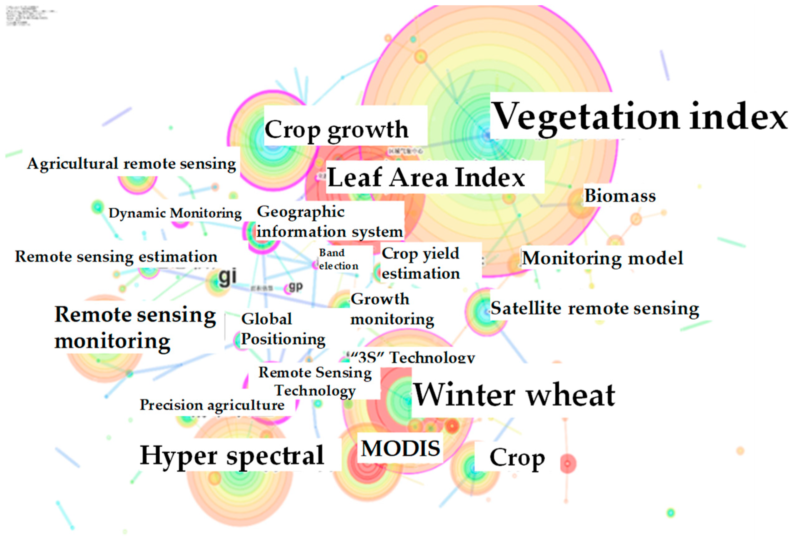
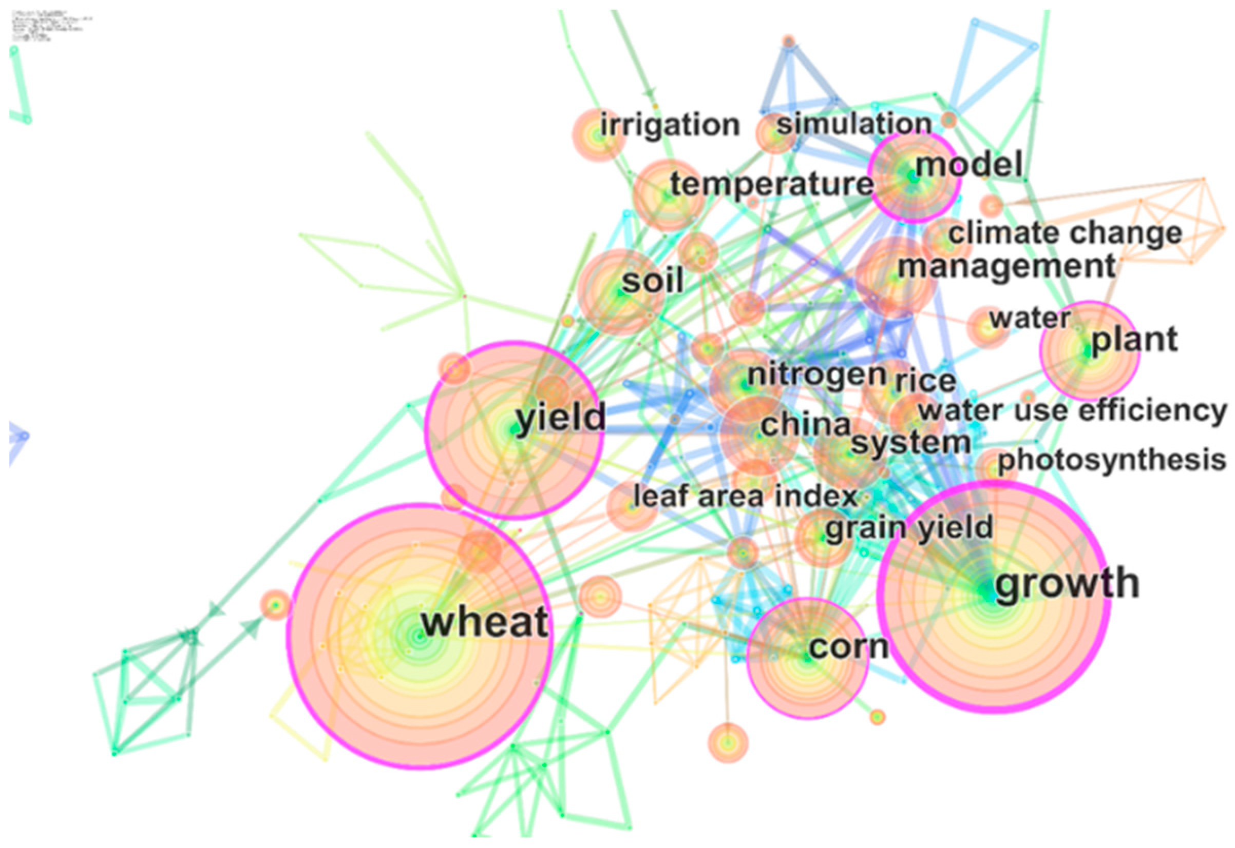
The change in number of published documents is an important index in measuring the research progress of a subject field. It can reflect the focus of attention over a targeted period of time. The number of journal papers published in the field of crop growth monitoring using remote sensing by Chinese scholars from 1996 to 2016 is shown in Figure 1. It can be observed that the number of papers increased rapidly over the years. The number of papers published in Chinese journals was larger than that published in English journals at the beginning. Start in 2013, research interests in crop growth monitoring experienced a faster increase, leading to a significant increase in the number of papers published. It is worth mentioning that there are more papers published in English journals than in Chinese journals after 2013. The data shows that Chinese scholars are becoming more favor of publishing in English journals for a wider exposition of their researches. This is also associated with an increased international collaborations.

3.2. Research Focus

Keywords are the core of academic papers, which are a highly summarized form of the contents [21]. In statistical analysis, it is often necessary to combine the occurrence frequency of similar keywords. In the network map, the size of the nodes represents the occurrence frequency of the keywords, which can reflect the degree of concern in a research field [22]. Therefore, the keywords with high frequency and a highly central nature represented by the literature are generally used to analyze the hotspots of a research subject, which indicates the topic of common concern among scholars in a certain research field [23].
Figure 2 is the network analysis map of keywords in the research field of remote sensing of crop growth monitoring in Chinese journals. Key nodes were identified according to their size; subsequently, research background and hot spots were revealed. Keywords with the highest occurrence frequency were listed in Table 1. “Vegetation index” appeared the most, and the time of occurrences was 126. “Winter wheat”, “leaf area index (LAI)”, “hyperspectral”, “crop growth”, “remote sensing monitoring”, and other relatively large nodes suggested that they were closely related to remote sensing research. Table 2 lists the top 10 high-frequency keywords in English journals, and Figure 3 is a coexisting network analysis map of keywords in English journals. It can be seen from Figure 3 and Table 2 that keywords frequently used by Chinese scholars for publishing papers in English journals were “wheat”, “growth”, “yield”, “corn”, “model”, etc.
The comparison of high-frequency keywords in Chinese and English journals shows that the high-frequency use of keywords in Chinese journals, such as vegetation index and LAI, reveals the principles or methods used in crop growth monitoring in China. It also indicates, to some extent, that the current monitoring of crop growth in China focused mainly on physiological indices such as LAI and vegetation indices obtained from remote sensing. However, in English publications, some keywords such as vegetation index and LAI were seldom used. On the contrary, key words such as “model” were more often used to study the theoretical, methodological, and mechanistic processes of crop growth in the English journals. To a certain extent, the above high-frequency keywords from Chinese and English periodicals by Chinese scholars can reflect the theories or methods which are adopted in remote sensing growth monitoring.
The central nature is another factor that reflects the role of the node in the network. The node with a higher central nature can also show the hotspots and direction of scientific research in recent years. The greater the centrality of the keywords, the more information they control among keywords, and the greater their influence and importance are in the network [21,22]. From Table 1 and Table 2, it can be seen that the keywords with high betweenness centrality in Chinese journals were “remote sensing technology”, “crop growth”, “vegetation index”, etc. However, in English journals, “growth”, “yield”, “model” etc., were the keywords with high betweenness centrality. The above central keywords are, generally in consistent with the high-frequency keywords, which constitutes the main theoretical system in the field of remote sensing growth monitoring in China. To some extent, the research hotspots in the field of crop growth monitoring are highlighted again.

3.3. Research Front

A research front is defined as an emergent and transient grouping of concepts and underlying research issues. The intellectual base of a research front is its citation and co-citation footprint in scientific literature, encompassing an evolving network of scientific publications cited by research front concepts [24]. A sudden burst of research interest can be regarded as a signal of research front [25]. As the most active part of the research field, research front plays an important role in shaping the overall direction of national research programs and promoting practical developmental applications of the field.
Table 3 depicts the top seven burst keywords in the field of crop growth monitoring using remote sensing technology. Based on the data in the table, the keyword with the strongest burst intensity was “LAI”, which began in 2012 and reached the intensity value of 7.81. LAI is an important vegetation parameter for crop growth analysis due to its relevance to light interception and photosynthesis by green vegetation. It is widely used not only in the fields of agriculture, forestry, and ecology, but also in the field of remote sensing-based crop growth monitoring and yield estimation [26]. In recent years, the burst intensity of LAI stayed at a high level due to the application of LAI as an input parameter into crop growth models. By far, the longest durations of burst intensity were seen for keywords “MODIS (Moderate Resolution Imaging Spectroradiometer)” and “LAI”, with each lasting for six years. Burst of “MODIS” began in 2006 and became weaker from 2011 onward. In contrast, “LAI” will continue to keep its high intensity. Due to the advantages of free access, wide band range, and high revisit frequency, “MODIS” has great application value in large-scale and mesoscale remote sensing. However, with the rapid development of remote sensing technology and the increasing demand of users for high-spatial-resolution satellite images in recent years, the role of coarse-pixel MODIS data gradually weakened. In addition, the latest burst keyword was UAV, which emerged earliest in 2015. With the development of science and technology, “UAV” gradually entered the civil field, and the use of UAV technology for remote sensing became a trend of development. Other words such as “winter wheat”, “GIS (Geographic Information System)”, and “TM (Thematic Mapper)” were also keywords with strong intensity of emergence, which also shows the objective of the study, the method adopted, the data processed, and so on. To some extent, the results indicate that they are also hotspots and frontiers for a certain period of time.

4. Discussion

With the rapid development of remote sensing technology and application in China, progress was made in remote sensing based on crop growth monitoring. In this study, both bibliometric and visual analyses were carried out in the field of remote sensing of crop growth monitoring researches published in Chinese and English journals from 1996 to 2016. From the analysis of high-frequency keywords and burst keywords, Chinese research development in this discipline was summarized below.

4.1. Basic Research and Method Development

Basic research plays a key role in the development of a discipline, and its quality is directly related to the consolidation and development of the discipline. Crop growth monitoring became an important application field of agricultural remote sensing, and it is strongly supported by Chinese government departments at all levels [2]. Scientific research institutions in China have also been involved in.
According to the analysis results of the CiteSpace knowledge map, the keywords of high frequency and centrality indicate that the monitoring of crop growth by remote sensing in theory and method is mainly carried out around the parameters of “vegetation index”, “LAI”, and so on. Once again, it demonstrates that vegetation index and LAI are recognized as important remote sensing indices in reflecting crop growth [27,28,29]. The numerical changes of vegetation index and other indices directly reflect the vegetation cover, phonological shift, growth condition, and seasonal dynamics. Therefore, in remote sensing of crop growth monitoring, most of the research work still relies on the relationship between vegetation indices and other agronomic parameters to establish a regression model using traditional empirical statistical methods.
The process of crop growth is a very complex bio-physiological process affected by various factors. Therefore, neither a vegetation index nor a crop growth model alone can accurately model crop growth process [30,31]. Vegetation index models generally use empirical statistical relationships; thus, the simulation accuracy and stability are often not guaranteed [30]. At the same time, the crop growth models have obvious advantages in crop growth and yield simulation, due to their physiological and biochemical basis. The classical crop growth models like Crop Environment Resource Synthesis (CERES), World Food Studies (WOFOST), Simulateur multidiscplinaire pour les Cultures Standard (STICS), etc. can take into account the impact of crop varieties and crop planting factors on crop growth and development [32,33,34]. However, when the crop growth model is developed from a single-point study for regional application, the large number of involved processes may potentially lead to a drastic increase in the number of parameters to model process errors. Furthermore, many difficulties are encountered in the acquisition of some macroscopic data and the regionalization of parameters due to the non-uniformity of the surface and near-surface environment. Therefore, crop growth models need to be optimized and upgraded to improve theoretical basis, simulation accuracy, and stability. Hence, from a theoretical point of view, it is necessary to further explore the factors affecting crop growth and their feedback mechanism, to strengthen the research on the relationship between remote sensing information and crop canopy physical and biochemical parameters, and to focus on the crop growth monitoring model in the future [35].
The emergence of “winter wheat” and “maize” as the research hotspots revealed the reality that the main crops monitored in China, as they are the staple food in the country. In addition, these two crops are cultivated over large areas in northern China; hence, it is relatively easier to obtain pure pixels, which are more suitable for the application of moderate-spatial-resolution satellite data, such as MODIS and TM. Compared with “winter wheat” and “maize”, the planting area of other crops is relatively small; thus, mixed pixels are common when using data obtained from medium to low resolution satellites [36]. However, with the fast advent of high-spatial-resolution sensors coupled with new remote sensing application methodology and software, the application of remote sensing for crop growth monitoring will increase.
The frequency of “MODIS” and “TM” is also high, suggesting that satellite image data of MODIS and TM were widely used in crop growth monitoring mainly due to their free data policy. Currently, numerous studies show that other free-access satellite data are becoming increasingly popular, for example, the application of environmental satellites, Sino-Pak Resource Satellites, Landsat 8, Sentinel, and Worldview [37,38]. It is worth mentioning that, in recent years, the Chinese satellites (environmental star HJ, GF, etc.) provided additional data for crop growth monitoring [39,40]. Thus, it is worth affirming that different types of data will be widely used in the future. Spatial-temporal information are the key to large and moderate-scale crop growth monitoring, therefore, the development of data assimilation techniques, multi-source data fusion, and the integrated use of multi-source remote sensing data will become increasingly important [41,42].

4.2. Research Trend

With the evolution of technological innovation, some new research topics are emerging, such as UAV. UAV is a new driving force for precision agriculture due to their flexible data acquisition capability, reduced airspace limitation, low flight cost, and high spatial resolution [43]. Many researches showed that UAV combined with a remote sensing system can acquire target information with high spatial information more efficiently, making it more advantageous compared to traditional satellites [44]. It further expands the application of remote sensing to smaller fields, therefore becomes the frontier means in agricultural research [45]. However, the application of UAV to crop growth monitoring is still far from mature. There are many challenges to be solved before it becomes a widely adopted means for operational application in precision farming.
Looking ahead, hyperspectral technology combined with “3S” can be used to establish an agricultural real-time monitoring system, which can realize the real-time monitoring of crop growth, and the rapid prediction and accurate evaluation of the crop situation [46]. However, due to the influence of weather conditions, data quality, and the applicability of the inversion model, the demand for precision agriculture to the extraction of farmland information is limited. With the transformation from precision agriculture to intelligent agriculture following the development of Internet+ (Industry 4.0 in Europe or Industrial Internet in the United States), the demand for crop growth monitoring will increase in the near future. The emergence of many hyperspectral and high-resolution sensors will provide us with more accurate observing data, and also makes it possible to further study intelligent agriculture [47]. Therefore, these sensors will become a major development direction in future of China.
Within the context of big data and cloud computing, it is anticipated that the continuous observation ability of multi-platform, multi-load, multi-scale, and multi-angle sensors will be able to provide large amount of data to support better crop growth monitoring [48]. The assimilation of remote sensing data can achieve dynamic monitoring of large-scale crop growth. Remotely sensed data with high temporal and spatial resolution provide continuous crop growth monitoring for entire growth cycles in the context of spatially explicit mapping. However, due to differences in spectral and temporal resolutions, view-illumination angles, sensor band specifications, data consistency between different sensors need to be considered. It involves a series of research subjects, such as image processing of multi-source data, scale conversion, and so on [49]. With technology development in big data analytics, cloud computing, Internet+, artificial intelligence, and other new technologies, monitoring capability and estimating accuracy are considered as the focus of crop growth monitoring in China at present and in the future.

5. Conclusions

Accurate and timely information on crop growth condition is critical for sustainable agricultural production. Remote sensing technology offers an indispensable means in providing spatially detailed observation throughout the crop growth cycle. In addition to guiding crop production, the data are increasingly used in yield forecast and crop insurance. With the aid of the CiteSpace software, data from the WOSTM core database and CNKI published by Chinese scholars in the field of remote sensing of crop growth monitoring over the past 20 years (1996–2006) were analyzed. Through quantitative visualization analysis, this study revealed the following information on the research hotspots:
(1)
From 1996 to 2016, the number of peer-reviewed journal papers on crop growth monitoring published in Chinese and English journals by Chinese scholars increased steadily, and the rate of increase showed an accelerating trend.
(2)
“Vegetation index”, “crop growth”, “winter wheat”, “LAI”, “yield”, and “model” were high-frequency keywords or keywords with strong centrality among Chinese scholars.
(3)
“UAV”, “LAI”, and other popular words represent the current research frontier of remote sensing growth monitoring.
Overall, bibliometric results from this CiteSpace-aided study provided a quantitative assessment of research development in the field of crop growth monitoring using remote sensing over the past 20 years in China; the above conclusions are a summary of the publications in Chinese and English journals by Chinese scholars. In addition to enriching our understanding on the historical development, current status, and future trend in this discipline in China, this study more importantly captured the collaborative effort among Chinese scholars from a wide range of organizations. Furthermore, results from this study can help both students and established researchers when making program plans and engaging in joint research efforts in the related fields in China.

Author Contributions

L.W. and J.S. conceptualized the study. L.W., G.Z. and Z.W. performed the experiments, analyzed the data, and wrote the draft. J.L., J.S. and L.L. helped edit the draft and provided critical comments to improve the paper.

Funding

This research was supported by the National Natural Science Funds of China (grant No. 41401397), the Natural Science Funds of Jiangsu Province (grant No. BK20140237), and the Jiangsu Undergraduate Training Programs for Innovation and Entrepreneurship (grant No. 201810320078Z).

Conflicts of Interest

The authors declare no conflicts of interest.

References

  1. Yang, B.J.; Pei, Z.Y. Definition of crop condition and crop monitoring using remote sensing. Trans. Chin. Soc. Agric. Eng. 1999, 15, 214–218. [Google Scholar] [CrossRef]
  2. Cheng, T.; Yang, Z.W.; Inoue, Y.; Zhu, Y.; Cao, W.X. Preface: Recent Advances in Remote Sensing for Crop Growth Monitoring. Remote Sens. 2016, 8, 116. [Google Scholar] [CrossRef]
  3. Li, W.G.; Li, B.B.; Wang, Z.M.; Zhang, Y.X.; Huang, X.J. Current situation and prospect of crop growth monitoring by remote sensing. Jiangsu Agric. Sci. 2006, 12–15. [Google Scholar] [CrossRef]
  4. Meng, J.H. Research to Crop Growth Monitoring Indicators with Remote Sensing. Ph.D. Dissertations, Graduate School of Chinese Academy of Sciences (Institute of Remote Sensing Applications), Beijing, China, 2006. [Google Scholar]
  5. Hank, T.B.; Bach, H.; Mauser, W. Using a remote sensing-supported hydro-agroecological model for field-scale simulation of heterogeneous crop growth and yield: Application for wheat in central Europe. Remote Sens. 2015, 7, 3934–3965. [Google Scholar] [CrossRef]
  6. Du, M.M.; Noguchi, N. Monitoring of Wheat Growth Status and Mapping of Wheat Yield’s within-Field Spatial Variations Using Color Images Acquired from UAV-camera System. Remote Sens. 2017, 9, 289. [Google Scholar] [CrossRef]
  7. Yang, G.J.; Liu, J.G.; Zhao, C.J.; Li, Z.H.; Huang, Y.B.; Yu, H.Y.; Xu, B.; Yang, X.D.; Zhu, D.M.; Zhang, X.Y.; et al. Unmanned Aerial Vehicle Remote Sensing for Field-Based Crop Phenotyping: Current Status and Perspectives. Front. Plant Sci. 2017, 8, 1111. [Google Scholar] [CrossRef] [PubMed]
  8. Jin, X.; Liu, S.; Baret, F.; Hemerlé, M.; Comar, A. Estimates of plant density of wheat crops at emergence from very low altitude UAV imagery. Remote Sens. Environ. 2017, 198, 105–114. [Google Scholar] [CrossRef]
  9. Bendig, J.; Yu, K.; Aasen, H.; Bolten, A.; Bennertz, S.; Broscheit, J.; Gnyp, M.L.; Bareth, G. Combining UAV-based plant height from crop surface models, visible, and near infrared vegetation indices for biomass monitoring in barley. Int. J. Appl. Earth Obs. Geoinf. 2015, 39, 79–87. [Google Scholar] [CrossRef]
  10. Wu, J.J.; Yang, Q.Y. Crop monitoring and yield estimation using synthetic methods in arid land. Geogr. Res. 2002, 21, 593–598. [Google Scholar] [CrossRef]
  11. Ma, Y.; Wang, S.; Li, Z.; Hou, Y.; Zhuang, L.; He, Y.; Wang, F. Monitoring winter wheat growth in North China by combining a crop model and remote sensing data. Int. J. Appl. Earth Obs. Geoinf. 2008, 10, 426–437. [Google Scholar] [CrossRef]
  12. Wu, B.; Meng, J.; Li, Q.; Yan, N.; Du, X.; Zhang, M. Remote sensing-based global crop monitoring: Experiences with China’s CropWatch system. Int. J. Digit. Earth 2014, 7, 113–137. [Google Scholar] [CrossRef]
  13. Chen, J.; Lin, H.; Pei, Z. Application of ENVISAT ASAR data in mapping rice crop growth in Southern China. IEEE Geosci. Remote Sens. Lett. 2007, 4, 431–435. [Google Scholar] [CrossRef]
  14. Yang, B.J.; Pei, Z.Y.; Zhou, Q.B.; Liu, H.Q. Key technologies of crop monitoring using remote sensing at a national scale: Progress and problems. Trans. Chin. Soc. Agric. Eng. 2002, 18, 191–194. [Google Scholar] [CrossRef]
  15. Shang, J.; Liu, J.; Ma, B.; Zhao, T.; Jiao, X.; Geng, X.; Huffman, T.; Kovacs, J.M.; Walters, D. Mapping spatial variability of crop growth conditions using RapidEye data in Northern Ontario, Canada. Remote Sens. Environ. 2015, 168, 113–125. [Google Scholar] [CrossRef]
  16. Chen, H.L.; Li, Y.; Zhang, H.W. Operational application and research review of crop growth monitoring with remote sensing. Meteorol. Environ. Sci. 2015, 38, 95–102. [Google Scholar] [CrossRef]
  17. Baker, M. Is there a reproducibility crisis? A Nature survey lifts the lid on how researchers view the crisis rocking science and what they think will help. Nature 2016, 53, 452–454. [Google Scholar] [CrossRef] [PubMed]
  18. Qiu, X. Systematic review: A more scientific and objective overview method. Doc. Inf. Knowl. 2010, 1, 15–19. [Google Scholar]
  19. Chen, C.; Leydesdorff, L. Patterns of connections and movements in dual-map overlays: A new method of publication portfolio analysis. J. Assoc. Inf. Sci. Technol. 2014, 65, 334–351. [Google Scholar] [CrossRef]
  20. Hu, K.; Qi, K.; Guan, Q.; Guan, Q.; Wu, C.; Yu, J.; Qing, Y.; Zheng, J.; Wu, H.; Li, X. A scientometric visualization analysis for night-time light remote sensing research from 1991 to 2016. Remote Sens. 2017, 9, 802. [Google Scholar] [CrossRef]
  21. Li, J.; Guo, X.H.; Jiang, K.; Lv, P.H. Preliminary study of knowledge map of safety science-based on data of safety science. China Saf. Sci. J. 2013, 23, 152–158. [Google Scholar]
  22. Li, J.; Chen, C.M. Mining and Visualization of Scientific Texts; Capital University of Economics & Business Press: Beijing, China, 2016; ISBN 9787563824649. [Google Scholar]
  23. Zhao, R.Y.; Guo, F.J.; Zhao, Y.H. Study of mainstream research fields and hot spots in the field of scientometrics. Lib. Inf. Serv. 2015, 59(2), 66–74. [Google Scholar]
  24. Chen, C. CiteSpace II: Detecting and visualizing emerging trends and transient patterns in scientific literature. J. China Soc. Sci. Tech. Inf. 2009, 28, 401–421. [Google Scholar] [CrossRef]
  25. Persson, O. The intellectual base and research fronts of JASIS 1986–1990. J. Am. Soc. Inf. Sci. Technol. 2010, 45, 31–38. [Google Scholar] [CrossRef]
  26. Sun, H.S. Extracting Planting Area and Growth Information of Paddy Rice Using Multi-Temporal MODIS Data in China. Ph.D. Dissertations, Zhejiang University, Hangzhou, China, 2009. [Google Scholar]
  27. Lv, J.M.; Chen, X.; Wang, X.P.; Bao, A.M. Analyses and practice on monitoring the growth of large-area cotton with MODIS data. Arid Land Geogr. 2004, 27, 118–123. [Google Scholar] [CrossRef]
  28. Wu, B.F.; Zhang, F.; Liu, C.L.; Zhang, L.; Luo, Z.M. An integrated method for crop condition monitoring. J. Remote Sens. 2004, 8, 498–514. [Google Scholar] [CrossRef]
  29. Wang, K.R. Monitoring and Application of Cotton Growth based on Remote Sensing Satellite. Ph.D. Dissertations, Chinese Academy of Agricultural Sciences, Beijing, China, 2008. [Google Scholar]
  30. Yan, Y.; Liu, Q.H.; Liu, Q.; Jing, L.I.; Chen, L.F. Methodolagy of winter wheat yield prediction based on assimilation of remote sensing data with crop growth model. J. Remote Sens. 2006, 10, 804–811. [Google Scholar]
  31. Huang, Q.; Tang, H.J.; Zhou, Q.B.; Wu, W.B.; Wang, L.M.; Zhang, L. Remote sensing based monitoring of planting structure and growth condition of major crops in Northeast China. Trans. Chin. Soc. Agric. Eng. 2010, 26, 218–223. [Google Scholar] [CrossRef]
  32. Dong, Y.Y.; Zhao, C.J.; Yang, G.J.; Chen, L.P.; Wang, J.H.; Feng, H.K. Integrating a very fast simulated annealing optimization algorithm for crop leaf area index variational assimilation. Math. Comput. Model. 2013, 58, 877–885. [Google Scholar] [CrossRef]
  33. Huang, J.X.; Sedano, F.; Huang, Y.B.; Ma, H.Y.; Li, X.L.; Liang, S.L.; Tian, L.Y.; Zhang, X.D.; Fan, J.L.; Wu, W.B. Assimilating a synthetic Kalman filter leaf area index series into the WOFOST model to improve regional winter wheat yield estimation. Agric. For. Meteorol. 2016, 216, 188–202. [Google Scholar] [CrossRef]
  34. Chen, Y.T.; Cournède, P.H. Data assimilation to reduce uncertainty of crop model prediction with Convolution Particle Filtering. Ecol. Model. 2014, 290, 165–177. [Google Scholar] [CrossRef]
  35. Fu, Y.; Yang, G.; Wang, J.; Song, X.; Feng, H. Winter wheat biomass estimation based on spectral indices, band depth analysis and partial least squares regression using hyperspectral measurements. Comput. Electron. Agric. 2014, 100, 51–59. [Google Scholar] [CrossRef]
  36. Wu, S.X.; Mao, R.Z.; Li, H.J.; Hou, M.T.; Yang, F. Review of crop condition monitoring using remote sensing in China. Chin. Agric. Sci. Bull. 2005, 21, 319–322. [Google Scholar] [CrossRef]
  37. Beck, P.S.A.; Atzberger, C.; Høgda, K.A.; Johansen, B.; Skidmore, A.K. Improved monitoring of vegetation dynamics at very high latitudes: A new method using MODIS NDVI. Remote Sens. Environ. 2006, 100, 321–334. [Google Scholar] [CrossRef]
  38. Martínez, B.; Gilabert, M.A. Vegetation dynamics from NDVI time series analysis using the wavelet transform. Remote Sens. Environ. 2009, 113, 1823–1842. [Google Scholar] [CrossRef]
  39. Li, D.; Lv, J.; Wang, C.; Liu, W.; Jiang, H.; Chen, S.S. Winter Wheat Leaf Area Index (LAI) Inversion Combining with HJ-1/CCD1 and GF-1/WFV1 Data. In Geo-Spatial Knowledge and Intelligence; Yuan, H., Geng, J., Bian, F., Eds.; GRMSE 2016, Communications in Computer and Information Science; Springer: Singapore, 2017; Volume 698. [Google Scholar]
  40. Zhou, Q.B.; Yu, Q.Y.; Jia, L.; Wu, W.B.; Tang, H.J. Perspective of Chinese GF-1 high-resolution satellite data in agricultural remote sensing monitoring. J. Integr. Agric. 2017, 16, 242–251. [Google Scholar] [CrossRef]
  41. Zhao, C.J. Advances of Research and Application in Remote Sensing for Agriculture. Trans. Chin. Soc. Agric. Mach. 2014, 45, 277–293. [Google Scholar] [CrossRef]
  42. Chen, Z.X.; Ren, J.Q.; Tang, H.J.; Shi, Y.; Leng, P.; Liu, J.; Wang, L.M.; Wu, W.B.; Yao, Y.M.; Hasiyuya. Progress and perspectives on agricultural remote sensing research and applications in China. J. Remote Sens. 2016, 20, 748–767. [Google Scholar]
  43. Xu, G.H.; Liu, Q.H.; Chen, L.F.; Liu, L.Y. Remote sensing for China’s sustainable development: Opportunities and challenges. J. Remote Sens. 2016, 20, 679–688. [Google Scholar]
  44. Shi, Z.; Liang, Z.Z.; Yang, Y.Y.; Guo, Y. Status and prospect of agricultural remote sensing. Trans. Chin. Soc. Agric. Mach. 2015, 46, 247–260. [Google Scholar] [CrossRef]
  45. Zhang, Z.Y.; Li, C.H. Application of Unmanned Aerial Vehicle Technology in Modern Agriculture. Agric. Eng. 2016, 6, 23–25. [Google Scholar] [CrossRef]
  46. Liu, J.G.; Zhao, C.J.; Yang, G.J.; Yu, H.Y.; Zhao, X.Q.; Xu, B.; Niu, Q.L. Review of field-based phenotyping by unmanned aerial vehicle remote sensing platform. Trans. Chin. Soc. Agric. Eng. 2016, 32, 98–106. [Google Scholar] [CrossRef]
  47. Meng, J.H.; Wu, B.F.; Du, X.; Zhang, F.F.; Zhang, M.; Dong, T.F. A review and outlook of applying remote sensing to precision agriculture. Remote Sens. Land Resour. 2011, 1–7. [Google Scholar] [CrossRef]
  48. Wang, L.J.; Dong, T.F.; Zhang, G.M.; Niu, Z. LAI retrieval using PROSAIL model and optimal angle combination of multi-angular data in wheat. IEEE J.-STARS 2013, 6, 1730–1736. [Google Scholar] [CrossRef]
  49. Song, Q.; Zhou, Q.B.; Wu, W.B.; Hu, Q.; Yu, Q.Y.; Tang, H.J. Recent progresses in research of integrating multi-source remote sensing data for crop mapping. Sci. Agric. Sin. 2015, 48, 1122–1135. [Google Scholar] [CrossRef]
Figure 1. The number of papers on remote sensing of crop growth monitoring published in Chinese and English journals by Chinese researchers in 1996–2016.
Remotesensing 11 00809 g001
Figure 2. Keyword co-occurrence network analysis in Chinese journals.
Remotesensing 11 00809 g002
Figure 3. Keyword co-occurrence network analysis in English journals.
Remotesensing 11 00809 g003
Table 1. Top 10 high-frequency keywords in Chinese journals.
No.WordsFrequencyBetweenness Centrality
1Vegetation index1260.33
2Winter wheat650.14
3Leaf area index590.18
4Hyperspectral530.08
5Crop growth430.58
6Remote sensing monitoring400.08
7MODIS360.06
8Crop250.09
9Remote sensing technology250.67
10Satellite remote sensing210.18
Table 2. Top 10 high-frequency keywords in English journals.
No.WordsFrequencyBetweenness Centrality
1Wheat1510.3
2Growth1310.45
3Yield1020.32
4Corn730.15
5Plant630.15
6Soil580.02
7Model570.32
8Management530.02
9China520.09
10Nitrogen480.08
Table 3. Top seven burst keywords of the crop growth field.
Key WordsIntensityStartingEnding1996–2017
96 97 98 99 00 01 02 03 04 05 06 07 08 09 10 11 12 13 14 15 16 17
LAI7.811920122017▂ ▂ ▂ ▂ ▂ ▂ ▂ ▂ ▂ ▂ ▂ ▂ ▂ ▂ ▂ ▂ ▃ ▃ ▃ ▃ ▃ ▃
UAV4.967920152017▂ ▂ ▂ ▂ ▂ ▂ ▂ ▂ ▂ ▂ ▂ ▂ ▂ ▂ ▂ ▂ ▂ ▂ ▂ ▃ ▃ ▃
GIS4.964119982002▂ ▂ ▃ ▃ ▃ ▃ ▃ ▂ ▂ ▂ ▂ ▂ ▂ ▂ ▂ ▂ ▂ ▂ ▂ ▂ ▂ ▂
Winter wheat4.533620102012▂ ▂ ▂ ▂ ▂ ▂ ▂ ▂ ▂ ▂ ▂ ▂ ▂ ▂ ▃ ▃ ▃ ▂ ▂ ▂ ▂ ▂
MODIS4.340620062011▂ ▂ ▂ ▂ ▂ ▂ ▂ ▂ ▂ ▂ ▃ ▃ ▃ ▃ ▃ ▃ ▂ ▂ ▂ ▂ ▂ ▂
TM3.773520072010▂ ▂ ▂ ▂ ▂ ▂ ▂ ▂ ▂ ▂ ▃ ▃ ▃ ▃ ▂ ▂ ▂ ▂ ▂ ▂ ▂ ▂
Crop yield estimation3.1719982002▂ ▂ ▃ ▃ ▃ ▃ ▃ ▂ ▂ ▂ ▂ ▂ ▂ ▂ ▂ ▂ ▂ ▂ ▂ ▂ ▂ ▂

