Modeling Urban Encroachment on the Agricultural Land of the Eastern Nile Delta Using Remote Sensing and a GIS-Based Markov Chain Model

Abstract
1. Introduction
2. Study Area
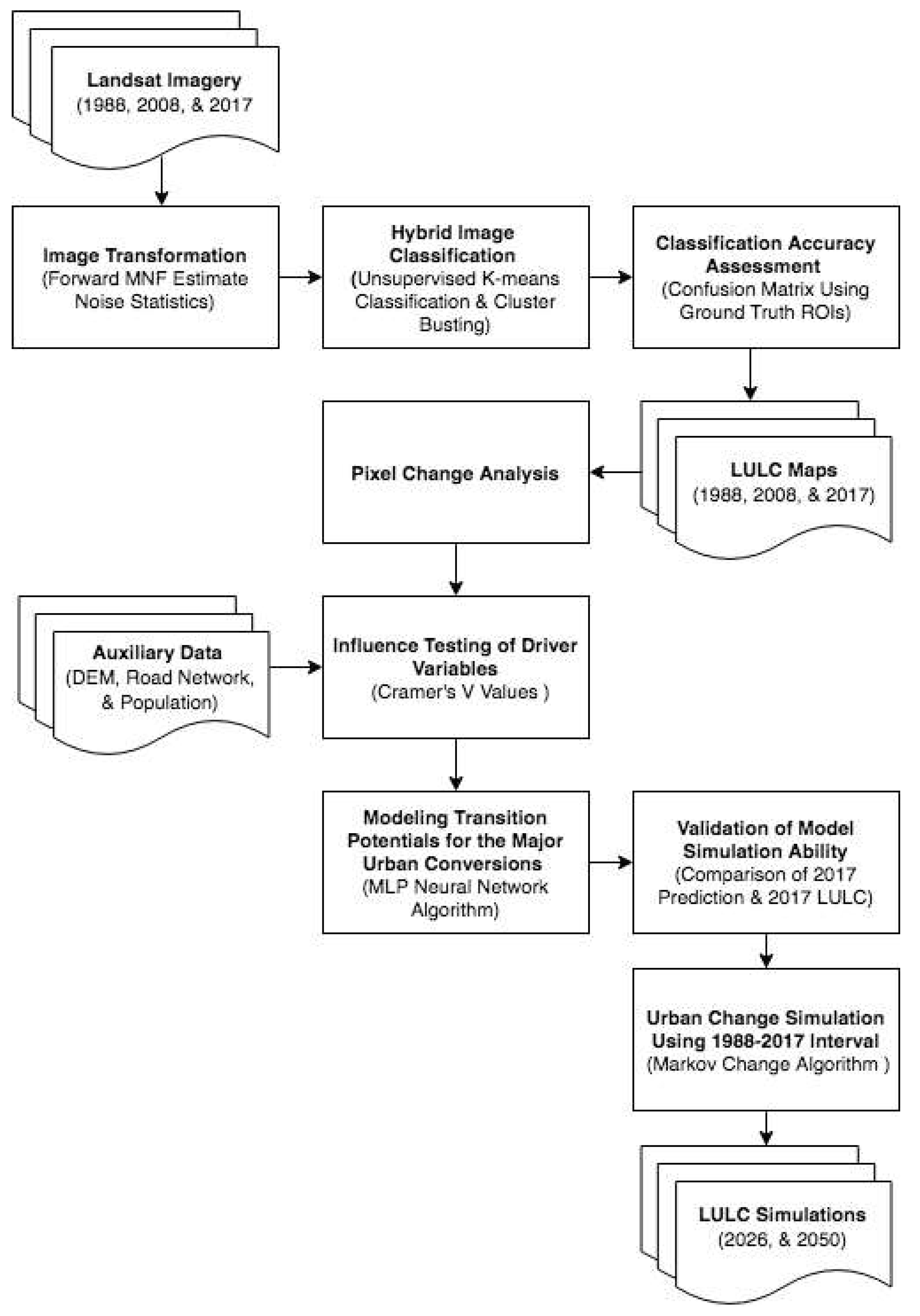
3. Materials and Methods
3.1. Data
3.2. LULC Maps Production and Accuracy Assessment
3.3. Model Implementation
3.3.1. Transition Potential Modeling and Driving Forces Determination
3.3.2. Change Simulation
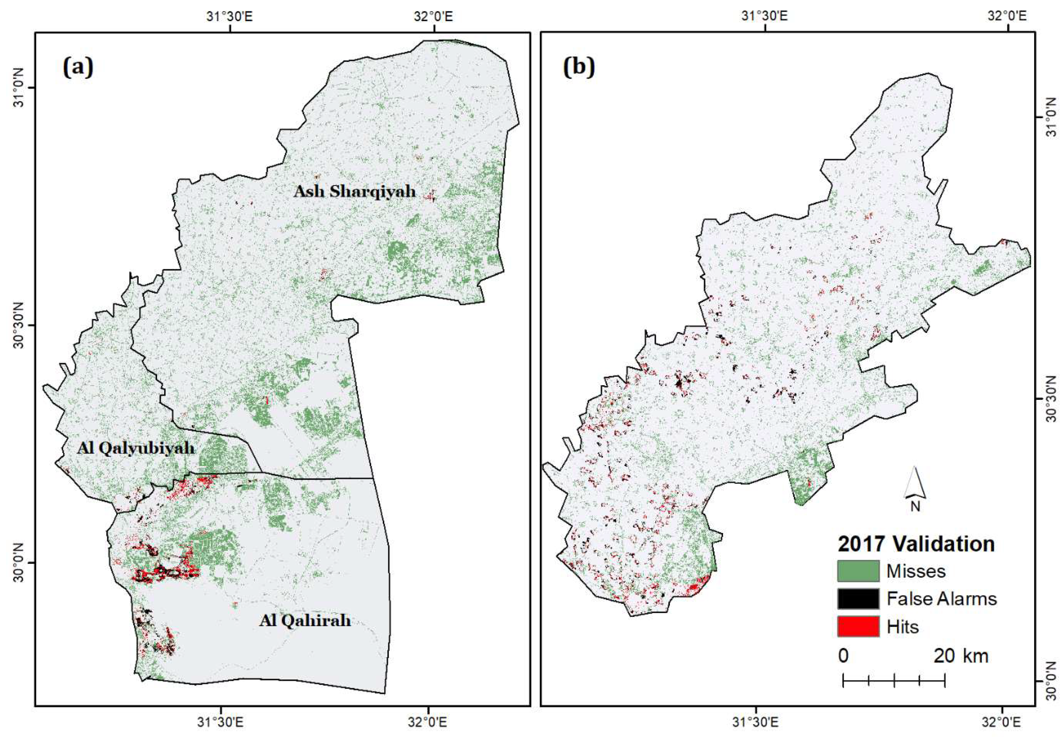
3.3.3. Model Validation
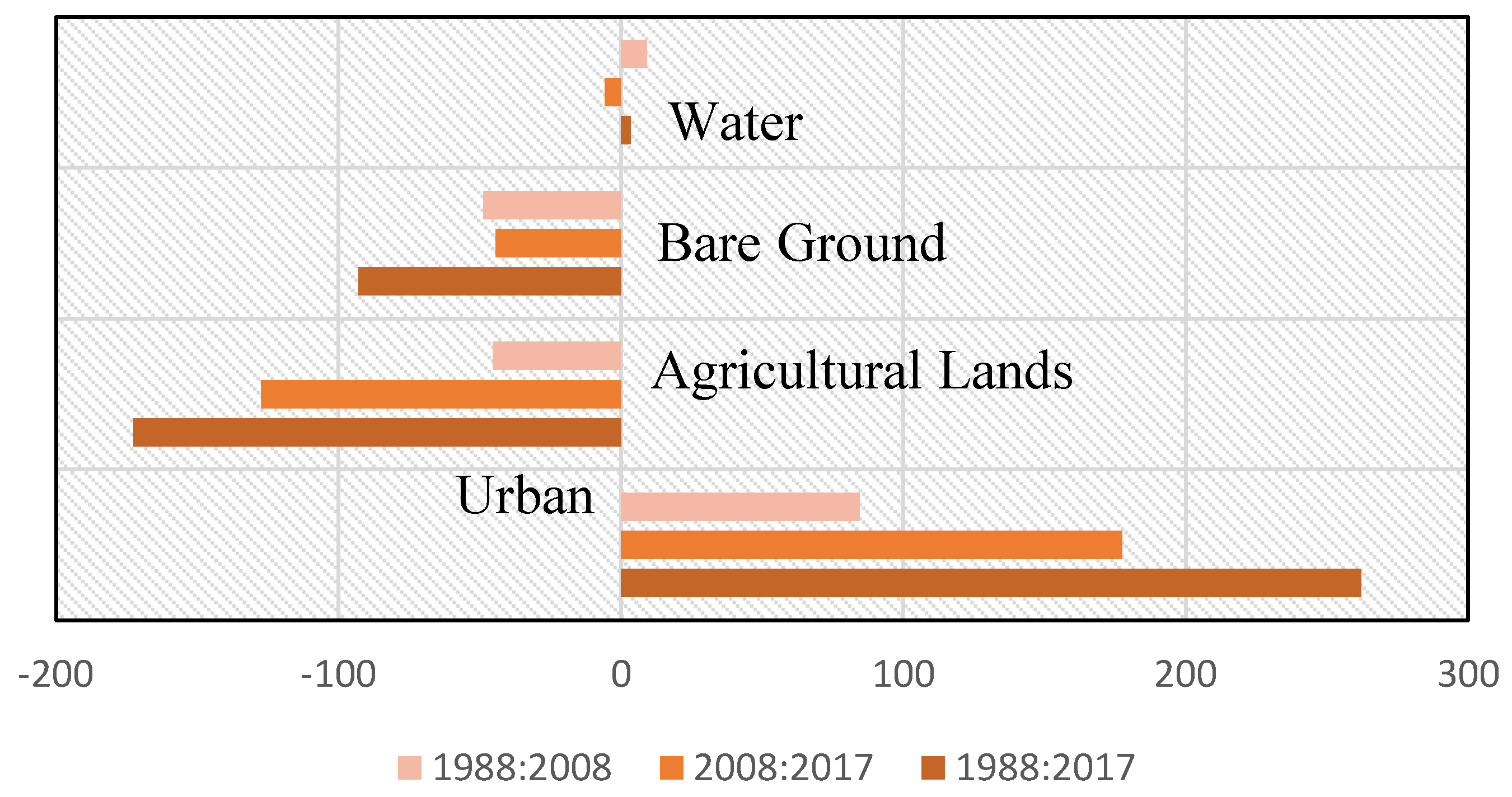
4. Results
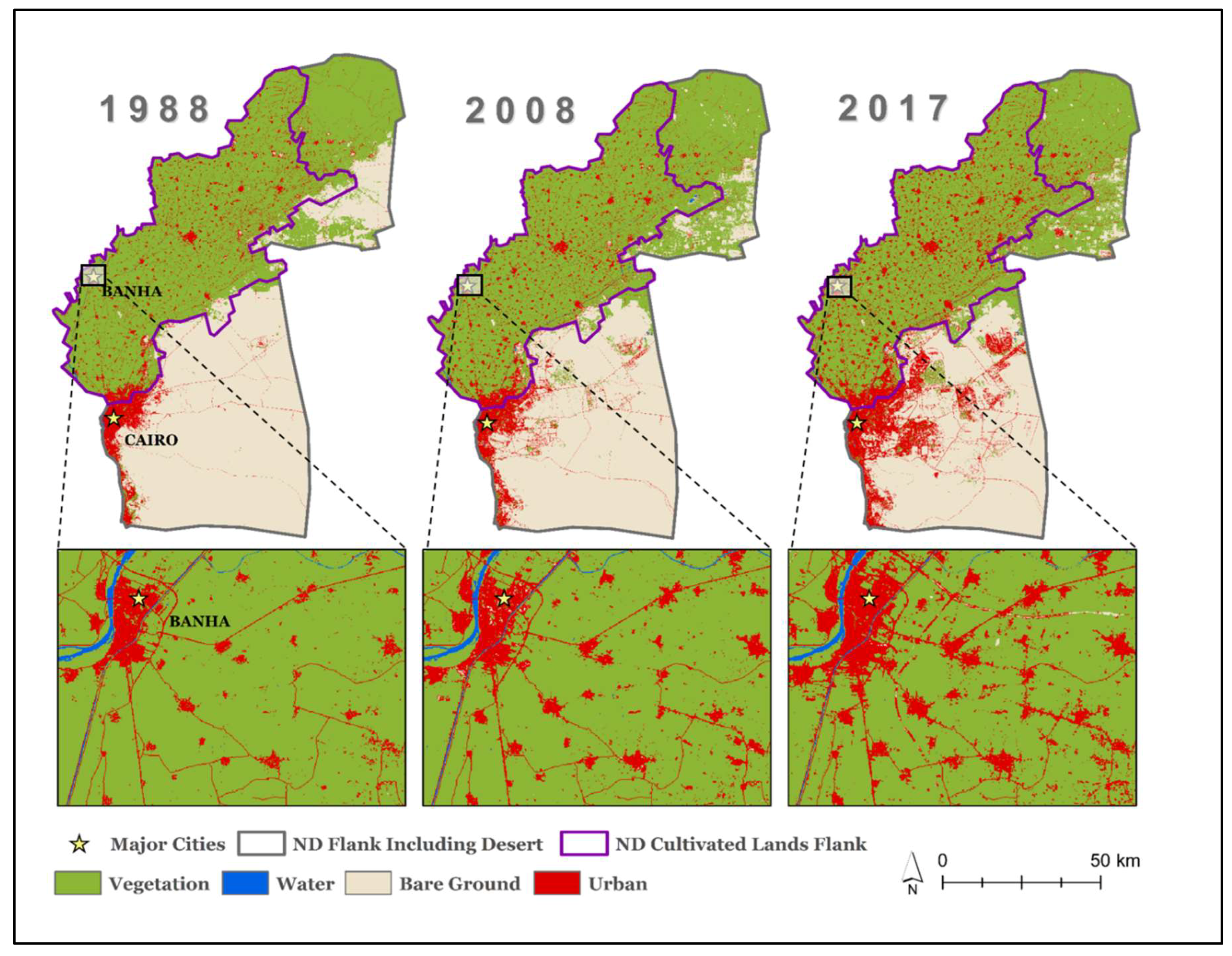
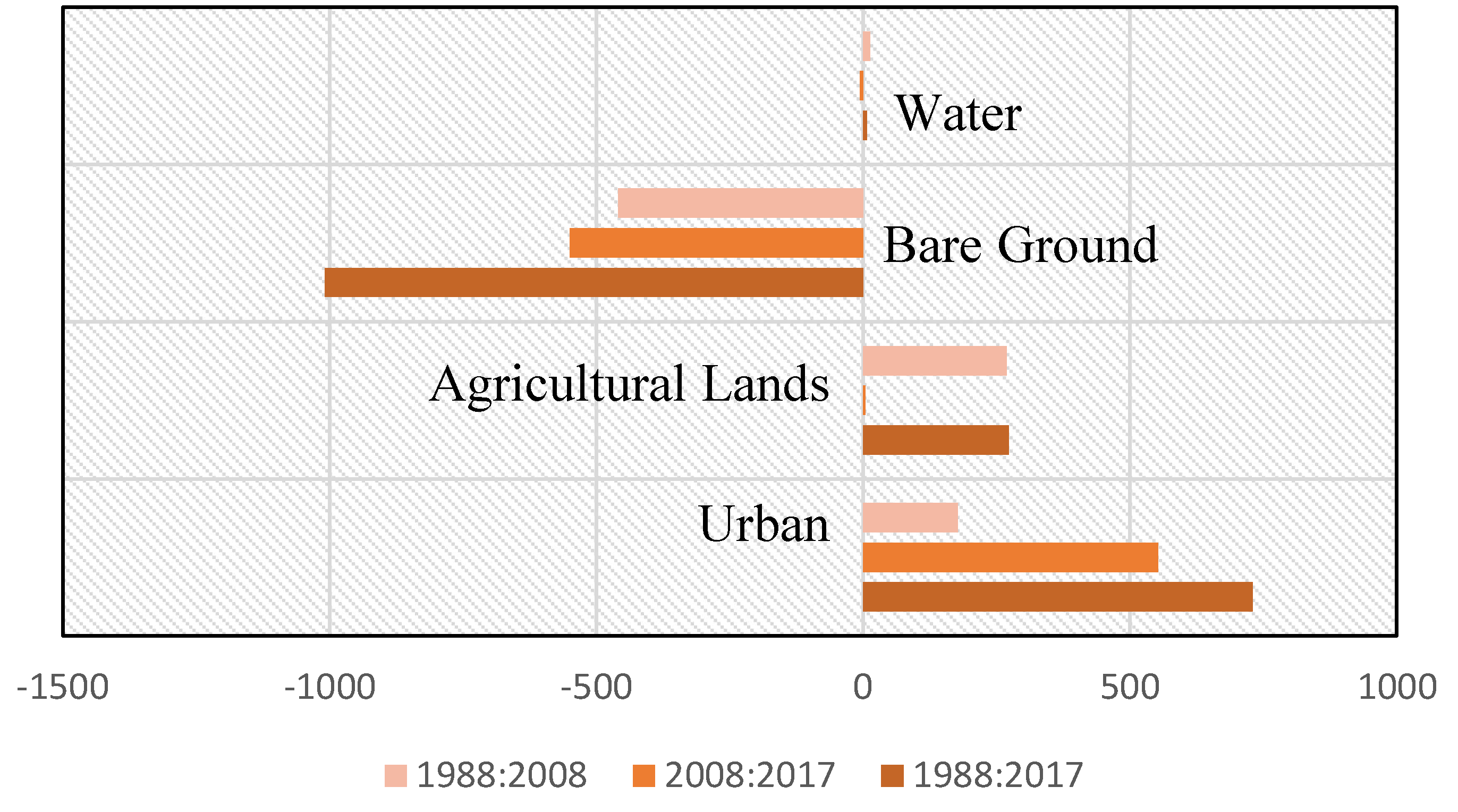
4.1. LULC Maps Production and Accuracy Assessment
4.2. Model Implementation
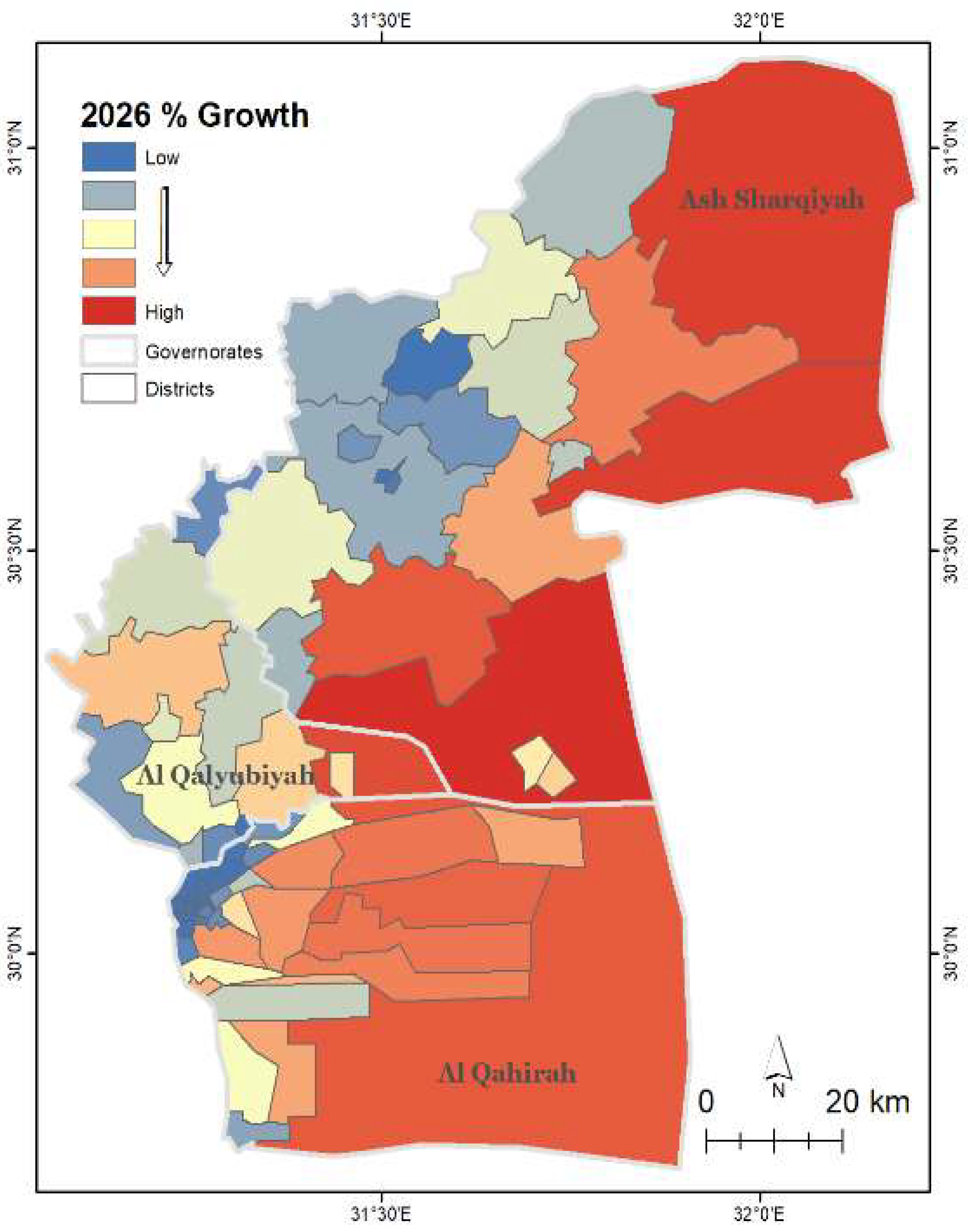
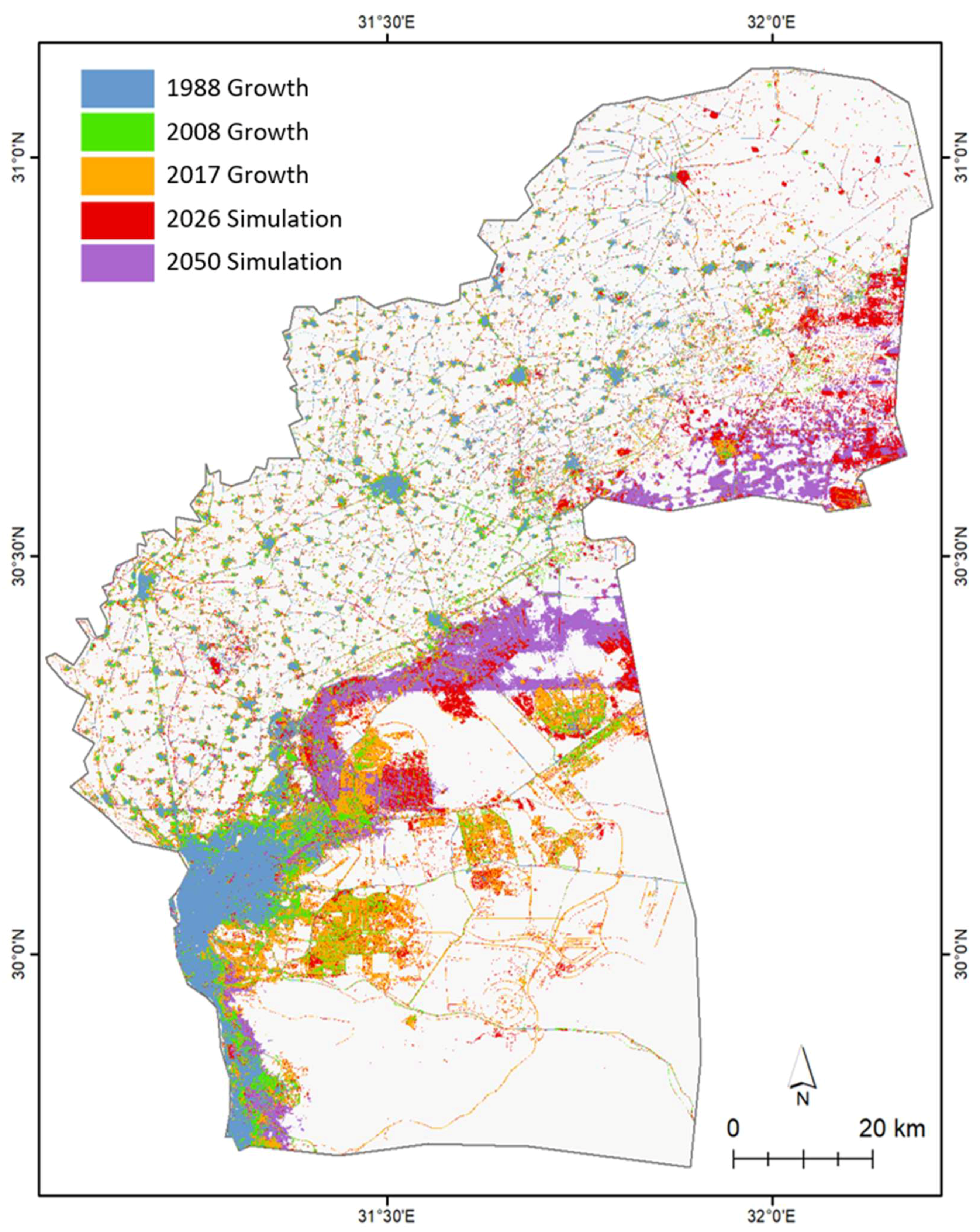
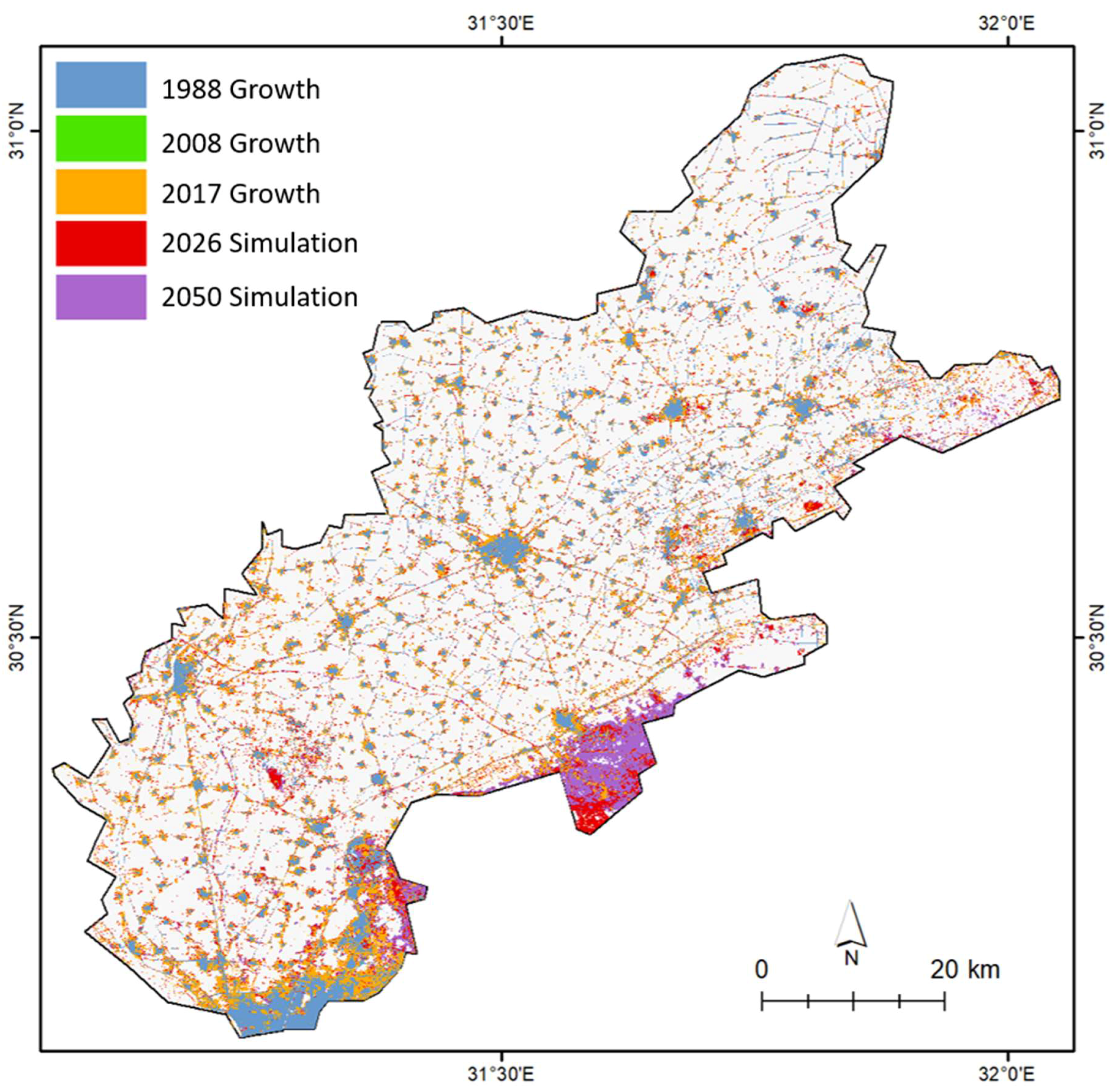
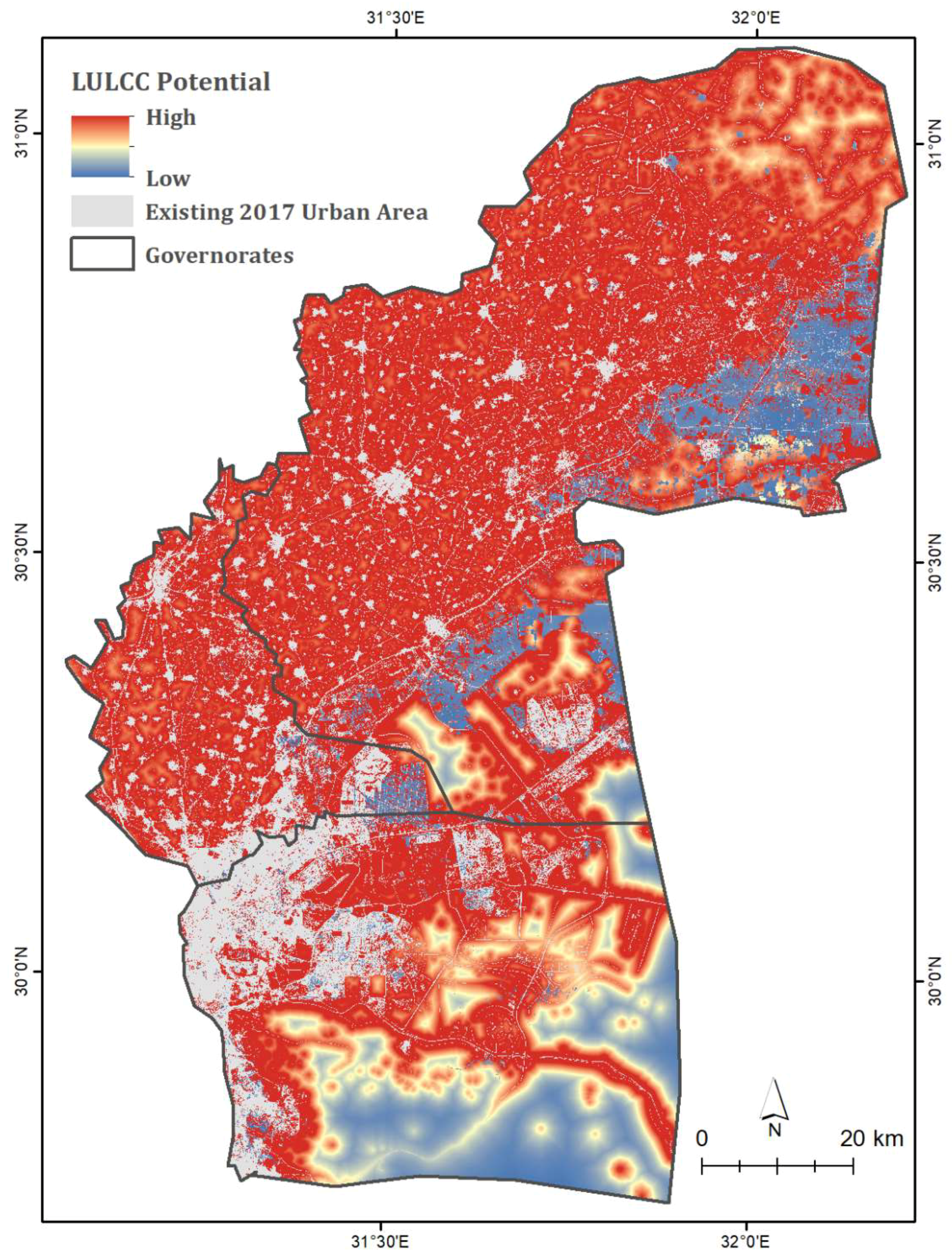
4.3. Future Impacts of Urbanization and Potential State of the ND
5. Discussion
6. Conclusions
Author Contributions
Funding
Acknowledgments
Conflicts of Interest
References
- Fresco, L.; Leemans, R.; Turner, B.L.; Skole, D.; Van Zeijl-Rozema, A.G.; Haarmann, V. Land Use and Cover Change (LUCC) Open Science Meeting Proceedings; Institut Cartogràfic de Catalunya: Catalonia, Spain, 1997. [Google Scholar]
- Turner, B.L. Local faces, global flows: The role of land use and land cover in global environmental change. Land Degrad. Dev. 1994, 5, 71–78. [Google Scholar] [CrossRef]
- Stanley, D.J.; Warne, A.G. Nile delta: Recent geological evolution and human impact. Science 1993, 260, 628–634. [Google Scholar] [CrossRef] [PubMed]
- Ye, D.; Fu, C. Major issues of global change sciences. Chin. J. Atmos. Sci. 1994, 18, 498–512. [Google Scholar]
- Clarke, K.C.; Hoppen, S.; Gaydos, L. A self-modifying cellular automaton model of historical urbanization in the San Francisco bay area. Environ. Plan. B Plan. Des. 1997, 24, 247–261. [Google Scholar] [CrossRef]
- Alphan, H. Land-use change and urbanization of adana, Turkey. Land Degrad. Dev. 2003, 14, 575–586. [Google Scholar] [CrossRef]
- López, T.D.; Aide, T.M.; Thomlinson, J.R. Urban expansion and the loss of prime agricultural lands in Puerto Rico. Ambio 2001, 30, 49–54. [Google Scholar] [CrossRef]
- Mckinney, M.L. Urbanization, biodiversity, and conservation. Bioscience 2002, 52. [Google Scholar] [CrossRef]
- Dewan, A.M.; Yamaguchi, Y. Land use and land cover change in greater Dhaka, Bangladesh: Using remote sensing to promote sustainable urbanization. Appl. Geogr. 2009, 29, 390–401. [Google Scholar] [CrossRef]
- Herold, M.; Goldstein, N.C.; Clarke, K.C. The spatiotemporal form of urban growth: Measurement, analysis and modeling. Remote Sens. Environ. 2003, 86, 286–302. [Google Scholar] [CrossRef]
- Lambin, E.F.; Baulies, X.; Bockstael, N.; Fischer, G.; Krug, T.; Leemans, R.; Moran, E.F.; Rindfuss, R.R.; Sato, Y.; Skole, D.; et al. Land-Use and Land-Cover Change (LUCC): Implementation Strategy; IGBP Report Stockholm: Bonn, Gremany, 1999. [Google Scholar]
- Work, I.S. Urbanization and urban development. Sage J. 1966, 9, 7–11. [Google Scholar]
- UNDESA. World Urbanization Prospects: The 2014 Revision; Department of Economic and Social Affairs: New York, NY, USA, 2014; pp. 1–32. [Google Scholar]
- Ahram. Egypt’s Population Reaches 104.2 Million: Census. Available online: http://english.ahram.org.eg/NewsContent/1/64/278013/Egypt/Politics-/Egypt%E2%80%99s-population-reaches--million-Census.aspx (accessed on 30 September 2017).
- UNDESA. World Population Prospects: The 2017 Revision. Population and Development Review; United Nations: New York, NY, USA, 2017. [Google Scholar]
- El-Kawy, O.A.; Rød, J.; Ismail, H.; Suliman, A. Land use and land cover change detection in the western Nile Delta of Egypt using remote sensing data. Appl. Geogr. 2011, 31, 483–494. [Google Scholar] [CrossRef]
- Overeem, I.; Syvitski, J.; Brakenridge, R.; Weichselgartner, J. Dynamics and Vulnerability of Delta Systems; LOICZ Reports & Studies; GKSS Research Center: Geesthacht, Germany, 2009; p. 54. [Google Scholar]
- Coleman, J.M.; Huh, O.K. Major World Deltas: A Perspective from Space. Coastal Studies Institute; Louisiana State University: Baton Rouge, LA, USA, 2003. [Google Scholar]
- Postel, S. Last Oasis: Facing Water Scarcity; Norton: New York, NY, USA, 1997. [Google Scholar]
- Döös, B.R. Population growth and loss of arable land. Glob. Environ. Chang. 2002, 12, 303–311. [Google Scholar] [CrossRef]
- El-Hefnawi, A.I. Protecting Agricultural Land from Urbanization or Managing the Conflict between Informal Urban Growth while Meeting the Demands of the Communities: Lessons Learnt from the Egyptian Policy Reforms; World Bank Urban Research Symposium: Brazil, 2005. Available online: https://pdfs.semanticscholar.org/0ae6/2e12ee59fc06d649d08c55c25c659004a38c.pdf (accessed on 1 September 2018).
- Ghar, M.A.; Shalaby, A.; Tateishi, R. Agricultural land monitoring in the egyptian nile delta using landsat data. Int. J. Environ. Studies 2004, 61, 651–657. [Google Scholar] [CrossRef]
- African, E.O. Sustainable Cities and Structural Transformation; AfDB; OECD; UNDP: Paris, France, 2016. [Google Scholar]
- FAO-UN. Statistical Pocketbook. Oecd-fao Agricultural Outlook 2015 OECD-FAO Agricultural Outlook. Available online: http://www.fao.org/3/a-i4738e.pdf (accessed on 1 September 2018).
- Barnes, J. Pumping possibility: Agricultural expansion through desert reclamation in Egypt. Soc. Stud. Sci. 2012, 42, 517–538. [Google Scholar] [CrossRef]
- Kamel, S.; Dahl, C. The economics of hybrid power systems for sustainable desert agriculture in Egypt. Fuel Energy Abstr. 2006, 47, 36. [Google Scholar] [CrossRef]
- Gober, P. Desert urbanization and the challenges of water sustainability. Curr. Opin. Environ. Sustain. 2010, 2, 144–150. [Google Scholar] [CrossRef]
- Parker, J.B.; Coyle, J.R. Urbanization and Agricultural Policy in Egypt; U.S. Department of Agriculture, Economic Research Service: Washington, DC, USA, 1981.
- Shalaby, A.; Tateishi, R. Remote sensing and gis for mapping and monitoring land cover and land-use changes in the northwestern coastal zone of Egypt. Appl. Geogr. 2007, 27, 28–41. [Google Scholar] [CrossRef]
- Liu, M.H.Q.; Tian, G.S.; Chen, W.; Ren, W.; Zhang, C.; Liu, J. Effects of land use and land cover change on evapotranspiration and water yield in China during the 20th century. J. Am. Water Resour. Assoc. 2008, 44, 1193–1207. [Google Scholar] [CrossRef]
- Radke, R.; Andra, S.; Al-Kofahi, O.; Roysam, B. Image change detection algorithms: A systematic survey. IEEE Trans. Image Process. 2005, 14, 294–307. [Google Scholar] [CrossRef] [PubMed]
- Hegazy, I.R.; Kaloop, M.R. Monitoring urban growth and land use change detection with gis and remote sensing techniques in Daqahlia Governorate Egypt. Intern. J. Sus. Built Environ. 2015, 4, 117–124. [Google Scholar] [CrossRef]
- Shalaby, A.; Ali, R.R.; Gad, A. Urban sprawl impact assessment on the agricultural land in egypt using remote sensing and GIS: A case study, Dalubiya Governorate. J. Land Use Sci. 2012, 7, 261–273. [Google Scholar] [CrossRef]
- Green, A.; Berman, M.; Switzer, P.; Craig, M. A transformation for ordering multispectral data in terms of image quality with implications for noise removal. IEEE Trans. Geosci. Remote Sens. 1988, 26, 65–74. [Google Scholar] [CrossRef]
- Harris, J.R.; Rogge, D.; Hitchcock, R.; Ijewliw, O.; Wright, D. Mapping lithology in Canadas Arctic: Application of hyperspectral data using the minimum noise fraction transformation and matched filtering. Canadian J. Earth Sci. 2005, 42, 2173–2193. [Google Scholar] [CrossRef]
- Jensen, J.R. Introductory Digital Image Processing: A Remote Sensing Perspective; Prentice-Hall: Upper Saddle River, NJ, USA, 2005; Volume 3. [Google Scholar]
- Pournamdari, M.; Hashim, M.; Pour, A.B. Application of ASTER and Landsat TM data for geological mapping of Esfandagheh Ophiolite Complex, southern Iran. Resour. Geol. 2014, 64, 233–246. [Google Scholar] [CrossRef]
- Piloyan, A.; Konečný, M. Semi-automated classification of landform elements in armenia based on SRTM dem using k-means unsupervised classification. Quaest. Geogr. 2017, 36, 93–103. [Google Scholar] [CrossRef]
- Gelbukh, A.; Morales, E.F. Micai 2008: Advances in Artificial Intelligence, Proceedings of the 7th Mexican International Conference on Artificial Intelligence, Atizapán de Zaragoza, Mexico, 27–31 October 2008; Springer: Berlin, Germany, 2008. [Google Scholar]
- Ozesmi, S.L.; Bauer, M.E. Satellite remote sensing of wetlands. Wetlands Ecology and Management 2014, 10, 381–402. [Google Scholar] [CrossRef]
- Eastman, J.R. Terrset Manual; Clark Labs, Clark University: Worcester, MA, USA, 2016. [Google Scholar]
- Megahed, Y.; Cabral, P.; Silva, J.; Caetano, M. Land cover mapping analysis and urban growth modelling using remote sensing techniques in greater cairo region, egypt. ISPRS Int. J. Geo-Inf. 2015, 4, 1750–1769. [Google Scholar] [CrossRef]
- Vaz, E.D.; Caetano, M.; Nijkamp, P. Trapped between antiquity and urbanism—A multi-criteria assessment model of the Greater Cairo metropolitan area. J. Land Use Sci. 2011, 6, 283–299. [Google Scholar]
- Dadhich, P.N.; Hanaoka, S. Markov Method Integration with Multi-Layer Perceptron Classifier for Simulation of Urban Growth of Jaipur City. In Proceedings of the 6th WSEAS International Conference on Remote Sensin, Iwate Prefectural University, Iwate, Japan, 6–8 October 2010. [Google Scholar]
- Sibanda, W.; Pretorius, P. Novel application of multi-layer perceptrons (mlp) neural networks to model hiv in South Africa using seroprevalence data from antenatal clinics. Int. J. Comput. Appl. 2011, 35, 26–31. [Google Scholar] [CrossRef]
- Khawaldah, H.A. A prediction of future land use/land cover in Amman area using GIS-based Markov Model and remote sensing. J. Geogr. Inf. Syst. 2016, 08, 412–427. [Google Scholar] [CrossRef]
- Hamdy, O.; Zhao, S.; Osman, T.; Salheen, M.; Eid, Y. Applying a hybrid model of markov chain and logistic regression to identify future urban sprawl in Abouelreesh, Aswan: A case study. Geosciences 2016, 6, 43. [Google Scholar] [CrossRef]
- Falahatkar, S.; Soffianian, A.R.; Khajeddin, S.J.; Ziaee, H.R.; Nadoushan, M.A. Integration of remote sensing data and gis for prediction of land cover map. Int. J. Geomat. Geosci. 2011, 1, 847–864. [Google Scholar]
- Kerekes, J. Receiver operating characteristic curve confidence intervals and regions. IEEE Geosci. Remote Sens. Lett. 2008, 5, 251–255. [Google Scholar] [CrossRef]
- Halmy, M.W.A.; Gessler, P.E.; Hicke, J.A.; Salem, B.B. Land use/land cover change detection and prediction in the north-western coastal desert of egypt using markov-ca. Appl. Geogr. 2015, 63. [Google Scholar] [CrossRef]
- Salem, B.B. Assessing habitat fragmentation and its effect on plant biodiversity using multidate satellite imagery. Case study: Omayed biosphere reserve (obr), western coastal desert of Egypt. Egypt. J. Desert Res. 2003, 53, 1–17. [Google Scholar]
- Malek, Ž.; Verburg, P.H.; Geijzendorffer, I.R.; Bondeau, A.; Cramer, W. Global change effects on land management in the mediterranean region. Glob. Environ. Chang. 2018, 50, 238–254. [Google Scholar] [CrossRef]
- Ayache, F.; Thompson, J.R.; Flower, R.J.; Boujarra, A.; Rouatbi, F.; Makina, H. Environmental characteristics, landscape history and pressures on three coastal lagoons in the southern mediterranean region: Merja zerga (morocco), Ghar el melh (Tunisia) and lake Manzala (Egypt). Hydrobiologia 2009, 622, 15–43. [Google Scholar] [CrossRef]
- Benoit, G.; Comeau, A. A Sustainable Future for the Mediterranean: The Blue Plan’s Environment and Development Outlook, 1st ed.; Routledge: London, UK, 2012; p. 462. [Google Scholar]
- Congalton, R.G. A review of assessing the accuracy of classifications of remotely sensed data. Remote Sens. Environ. 1991, 37, 35–46. [Google Scholar] [CrossRef]
- Lizuka, K.; Johnson, B.; Onishi, A.; Magcale-Macandog, D.; Endo, I.; Bragais, M. Modeling future urban sprawl and landscape change in the Laguna de bay area, Philippines. Land 2017, 6, 26. [Google Scholar]


| Driver Variable | Cramer’s V Value |
|---|---|
| Distance to Urban 1988 | 0.4844 |
| Elevation | 0.4415 |
| Distance to Disturbances 1988:2017 | 0.4077 |
| Distance to Bare Ground 1988 | 0.4658 |
| Population | 0.2295 |
| Distance to Water 1988 | 0.0347 |
| Slope | 0.0256 |
| Driver Variable | Cramer’s V Value |
|---|---|
| Evidence Likelihood | 0.3628 |
| Distance to Urban 1988 | 0.3462 |
| Elevation | 0.0238 |
| Distance to Disturbances 1988:2017 | 0.3548 |
© 2018 by the authors. Licensee MDPI, Basel, Switzerland. This article is an open access article distributed under the terms and conditions of the Creative Commons Attribution (CC BY) license (http://creativecommons.org/licenses/by/4.0/).
Share and Cite
Bratley, K.; Ghoneim, E. Modeling Urban Encroachment on the Agricultural Land of the Eastern Nile Delta Using Remote Sensing and a GIS-Based Markov Chain Model. Land 2018, 7, 114. https://doi.org/10.3390/land7040114
Bratley K, Ghoneim E. Modeling Urban Encroachment on the Agricultural Land of the Eastern Nile Delta Using Remote Sensing and a GIS-Based Markov Chain Model. Land. 2018; 7(4):114. https://doi.org/10.3390/land7040114
Chicago/Turabian StyleBratley, Kelsee, and Eman Ghoneim. 2018. "Modeling Urban Encroachment on the Agricultural Land of the Eastern Nile Delta Using Remote Sensing and a GIS-Based Markov Chain Model" Land 7, no. 4: 114. https://doi.org/10.3390/land7040114
APA StyleBratley, K., & Ghoneim, E. (2018). Modeling Urban Encroachment on the Agricultural Land of the Eastern Nile Delta Using Remote Sensing and a GIS-Based Markov Chain Model. Land, 7(4), 114. https://doi.org/10.3390/land7040114