
Article

Urban Expansion and Landscape Transformation: Impacts on Natural Land Cover and Fragmentation in Lokoja Metropolis, Nigeria (2000–2024)

by
Happy Oyenje John-Nwagwu
1,*,
Nnachi Ikwuo Nnachi
1,
Rosemary Okikiola John
1,
Ngozi Gloria Johnson
2,
Edith Makwe
3 and
Olufayokemi Rasheedat Oyesanmi
1
1
Department of Geography, Federal University, Lokoja 260001, Nigeria
2
African Regional Institute for Geospatial Information Science and Technology, Ile-Ife 220001, Nigeria
3
Department of Geography and Environmental Management, University of Abuja, Abuja 900001, Nigeria
*
Author to whom correspondence should be addressed.
Biosphere 2026, 2(3), 6; https://doi.org/10.3390/biosphere2030006
Submission received: 24 March 2026 / Revised: 17 June 2026 / Accepted: 18 June 2026 / Published: 30 June 2026
(This article belongs to the Special Issue Sustainable and Resilient Biosphere)

Abstract

Lokoja, the capital of Kogi State, Nigeria, situated at the confluence of the Niger and Benue Rivers, has experienced rapid urban expansion alongside heightened environmental risks, including flooding and ecosystem degradation. Using multi-temporal Landsat imagery (2000, 2010, 2020, 2024), Random Forest classification, and landscape metrics, this study analyses spatio-temporal patterns of urban growth and fragmentation in this underrepresented mid-sized African city. Urban land cover expanded from 6668 ha in 2000 to 15,985 ha in 2024 (net ~140% growth), following a non-linear trajectory of rapid expansion (2000–2010), partial consolidation (2010–2020), and renewed growth with intensified fragmentation (2020–2024). This growth caused severe ecological impacts: dense forest declined by 99.7% (from 373 ha to 1 ha), woodland by 73.9%, and core natural land cover by 23% to 13.8% of the landscape, below critical ecological thresholds. Edge density rose by 121%, exacerbating urban heat, runoff, and biodiversity loss, while apparent gains in grassland largely reflect secondary succession rather than recovery. This study recommends enforcing development restrictions below 10 m in elevation, with 100 m riparian buffers; restoring 500 ha of native corridors; mandating 20% urban tree canopy cover; and establishing community-based green space monitoring. The findings provide empirical insights into sustainability challenges facing mid-sized African cities and offer transferable strategies for ecologically sensitive urban planning.

1. Introduction

Urban expansion, the outward growth of built-up areas, population, and associated infrastructure, is a defining feature of contemporary global development. Driven by population increase, economic opportunities, and demand for housing and services, cities worldwide have converted vast areas of natural and agricultural land [1,2,3]. While this process fuels socio-economic progress, it often comes at a high ecological cost. Globally, urban expansion has led to widespread habitat loss, fragmentation, biodiversity decline, and the disruption of critical ecosystem services such as flood regulation, carbon sequestration, and climate moderation [4,5,6]. In many regions, core natural habitats have shrunk below ecological viability thresholds, resulting in increased urban heat island effects, heightened flood vulnerability, and reduced resilience to climate change [7,8].
In sub-Saharan Africa, these challenges are particularly acute. Rapid, often unplanned urbanisation has transformed peri-urban landscapes, converting wetlands, woodlands, and farmlands into fragmented urban mosaics [9,10]. Cities in the region frequently expand into ecologically sensitive zones such as river floodplains, amplifying disaster risks and degrading essential ecosystem services. Lokoja, the capital of Kogi State, Nigeria, located at the confluence of the Niger and Benue Rivers, exemplifies these dynamics. With a rapidly growing population (estimated at around 900,000 in recent projections), the city has experienced substantial urban sprawl driven by its administrative functions, road networks, housing developments, and commercial activities [10,11].
This growth has visibly transformed local landscapes. Wetlands that once served as natural flood buffers and biodiversity hotspots are increasingly drained for construction, while savanna woodlands rich in non-timber resources face clearance for fuelwood, infrastructure, and settlements. The resulting leapfrog development pattern has intensified habitat fragmentation, soil erosion, altered hydrology, and flood risks along the river corridors. These changes mirror broader African and global trends but remain understudied in medium-sized riverine cities like Lokoja.
Natural habitats play a vital role in maintaining biodiversity, regulating local climate, improving air and water quality, and enhancing urban resilience. Their loss not only threatens species and ecological balance but also diminishes human well-being by reducing recreational spaces, aesthetic value, and protection against hazards such as flooding and extreme heat [4,5,12]. In Lokoja, where informal and scattered settlements encroach on floodplains and natural vegetation, these pressures raise urgent questions about long-term sustainability.
This study clearly distinguishes between “natural land cover” and “habitat.” “Natural land cover” refers to biophysical surface features such as forests, woodlands, grasslands, and wetlands derived from remote sensing classification, whereas “habitat” is used in a stricter ecological sense to describe species-specific environments. Accordingly, this study primarily assesses changes in natural land cover and landscape structure as proxies for ecological conditions, while references to habitat are limited to ecological interpretation. This distinction is necessary to avoid conceptual ambiguity and ensure consistency with landscape ecology and remote sensing frameworks.
Despite growing recognition of these issues, detailed spatio-temporal analyses of urban expansion and its specific impacts on natural habitats in mid-sized Nigerian cities remain limited. This study addresses that gap by examining the impact of urban expansion on natural habitats in Lokoja Metropolis from 2000 to 2024. Specifically, it aims to (1) map and analyse spatio-temporal patterns of urban growth using multi-date Landsat imagery; (2) quantify changes in vegetation types and habitat fragmentation; and (3) provide evidence-based recommendations for integrating habitat conservation into sustainable urban planning.

Problem Statement

Lokoja, the capital of Kogi State, Nigeria, has experienced rapid population growth and urban expansion over the past few decades. This growth, driven by rural–urban migration, economic opportunities, and its strategic administrative and transport functions, has largely occurred in an unplanned, poorly regulated manner. The result has been sprawling, low-density development that inefficiently consumes land and encroaches on ecologically sensitive areas [13,14,15].
As built-up areas expand into wetlands, farmlands, and savanna woodlands, Lokoja faces escalating environmental challenges. These include significant biodiversity loss, fragmentation of natural land cover, degradation of critical ecosystem services (such as flood regulation and carbon sequestration), heightened flood vulnerability along the Niger–Benue confluence, and increased urban heat and pollution. Unplanned growth has also strained infrastructure and undermined long-term environmental and socio-economic sustainability [3,16,17].
Despite these pressing issues, there remains limited empirical research that systematically maps and analyses the spatio-temporal dynamics of urban expansion and its specific impacts on natural land cover and landscape structure in Lokoja. Existing studies provide general insights but lack detailed quantification of land-use/land-cover changes, landscape fragmentation metrics, and links to ecological thresholds over multiple decades.
This gap hinders evidence-based urban planning, effective environmental management, and informed policy-making. To address it, this study examines the impact of urban expansion on natural land cover and associated ecological conditions in Lokoja Metropolis from 2000 to 2024. Specifically, it seeks to achieve the following:
(a)
Map and analyse the spatio-temporal patterns of urban growth using multi-temporal Landsat imagery and Random Forest classification.
(b)
Quantify changes in key vegetation types and measure landscape fragmentation using spatial metrics.
(c)
Assess the ecological consequences of these changes on land cover extent, core areas, and landscape connectivity.
(d)
Provide evidence-based recommendations for sustainable urban planning and ecological conservation in riverine mid-sized cities.

2. Literature Review

The conversion of natural and peri-urban landscapes into impervious built environments, driven by urban expansion, remains a primary driver of global landscape degradation, with rapid urban growth in Africa projected to significantly impact biodiversity-rich regions through vegetation loss, land cover fragmentation, and ecosystem disruption [10,18].
In West Africa, urban growth is characterised by low-density, informal sprawl driven by population pressure, weak governance, and inadequate spatial planning [9,15]. In Nigeria, this manifests as unregulated encroachment on wetlands, riparian forests, and farmlands, amplifying ecological decline and hydrological vulnerability [16,19].
Empirical evidence from various Nigerian cities consistently shows rapid land use/land cover change (LULCC) driven by urban expansion. In Akure (1972–2002), the built-up area increased by over 300%, accompanied by sharp declines in vegetation and bare surfaces, indicative of outward sprawl and ecological simplification [20]. Makurdi (1999–2012) saw farmland decrease from 43% to 22%, with significant conversion to settlements, underscoring urban-agricultural conflicts [21,22]. In Obio/Akpor, Rivers State (2000–2018), wetland cover declined from 9% to less than 5% due to residential and infrastructural development, heightening flood risk and exacerbating biodiversity loss [23]. Uncontrolled sprawl in Ibadan’s Eleyele Wetland impaired its flood regulation and water purification functions [24], while multi-decadal analysis in Lagos revealed over 60% expansion of impervious surfaces alongside steep declines in green and open spaces, eroding urban ecological resilience [25].
Despite advances in GIS and remote sensing, links between urban expansion, biodiversity, and ecosystem services remain underexplored in mid-sized cities. Lokoja, at the Niger–Benue confluence, exemplifies this challenge, where growth encroaches on floodplains, savanna woodlands, and hillsides. Using multi-decadal Landsat imagery (2000–2024), landscape fragmentation analysis, and field validation, this study maps changes in natural land cover, identifies high-risk wards, and proposes GIS-based conservation strategies. Findings highlight extensive fragmentation and ecosystem pressure, emphasising the need for sustainable urban planning. The approach provides a replicable framework for balancing urban growth and biodiversity conservation in ecologically sensitive African cities.

2.1. Urban Expansion and Landscape Fragmentation

Urban expansion is widely recognised as a leading driver of landscape fragmentation and ecological degradation, particularly in rapidly urbanising regions. Fragmentation occurs when continuous natural land cover is divided into smaller, isolated patches, reducing ecological connectivity and increasing edge effects [26]. These processes significantly alter ecosystem structure and function, affecting species distribution, ecological flows, and overall landscape resilience.
In urban environments, fragmentation is often intensified by road networks, residential development, and infrastructure expansion, which create discontinuities within natural landscapes. Metrics such as patch density, edge density, and core area are commonly used to quantify these changes and assess ecological integrity [27]. Increased edge density, for example, has been associated with higher exposure to environmental stressors such as temperature fluctuations, invasive species, and surface runoff.
In sub-Saharan Africa, rapid urbanisation has accelerated land cover fragmentation, particularly in ecologically sensitive regions such as wetlands, savanna woodlands, and riverine systems [1,23]. However, while large metropolitan regions have been extensively studied, fragmentation dynamics in mid-sized cities remain poorly understood.

2.2. Findings on Landscape Fragmentation and Ecological Change

Empirical evidence from Lokoja consistently reveals that rapid urban expansion has been the dominant driver of vegetation loss and land cover fragmentation over the past three decades. Early studies (2006–2012) using Landsat imagery by [28,29] documented a 38–51% decline in vegetation and a more than tenfold increase in built-up areas, largely driven by administrative restructuring and transport corridor development.
More recent analyses (2016–2023) using higher-resolution Sentinel-2 and QuickBird imagery and advanced machine learning techniques provided clearer spatial insights. Reference [30] identified extensive conversion of riparian vegetation to informal settlements, while [14] applied Random Forest classification and CA–Markov modelling to show that vegetation cover in Lokoja declined from 90.2% to 68.4% (1988–2018), with projections indicating an additional 35% loss by 2028, underscoring the accelerating threat of urban sprawl to savanna ecosystems. The Niger–Benue confluence was identified as a major hotspot of landscape fragmentation.
The most advanced work by [14] integrated NDVI time-series analysis with Support Vector Machine classification (91.2% accuracy), revealing a strong correlation (R2 = 0.99, p < 0.001) between urban expansion and declining vegetation health (NDVI values ranging from 0.62 to 0.41). Spatial autocorrelation (Moran’s I = 0.78) confirmed clustered landscape degradation, particularly in the southwestern zone of Lokoja.
Despite methodological progress, critical gaps persist—particularly the lack of biodiversity assessments, weak integration of hydrological and socio-economic data, limited field validation, and inadequate exploration of climate–ecosystem linkages such as urban heat stress.

2.3. Theoretical Framework

This study employs a four-pronged theoretical framework to explore the link between urban expansion and ecological change in Lokoja Metropolis, Nigeria. LULCC Theory explains the mechanisms of land transformation through socio-ecological conversion processes [31], while Compact City Theory critiques the inefficiencies of unplanned sprawl [32]. Urban Ecology Theory highlights the decline in ecosystem services as landscapes urbanise [33], and Landscape Fragmentation Theory examines habitat fragmentation through patch isolation and edge effects [26,34]. In essence, LULCC Theory structures land-change analysis, Compact City Theory critiques spatial patterns, Urban Ecology Theory explains ecological impacts, and Landscape Fragmentation Theory provides a basis for interpreting habitat structure and connectivity.

2.4. Research Gaps and Study Justification

Urban expansion across Africa is increasingly documented, yet mid-sized cities like Lokoja—home to about 280,000 residents at the confluence of the Niger and Benue rivers [35] —remain largely overlooked. Despite rapid administrative growth, surging informal settlements, and ecologically sensitive riverine–savanna landscapes [9,11], few studies have captured the full environmental implications of urban growth. Evidence indicates dramatic transformations: built-up areas grew from 3.57% in 1990 to 21.59% in 2019, forest cover declined by 76%, and vegetation health (NDVI) steadily deteriorated [14]. Between 1988 and 2018, vegetation cover fell from 90% to 68%, while built-up areas expanded by up to 23% [29]. These shifts reflect not only spatial growth but also land cover fragmentation, biodiversity loss, and diminished flood regulation in vulnerable floodplains.
Critical gaps remain. First, mid-sized cities are largely invisible in urban-environment research; most global studies focus on high-income countries, with only 7% from low- and middle-income contexts [1]. Second, studies in Lokoja emphasise vegetation loss and LULC change [28] but seldom consider diverse ecological systems (riparian wetlands, savanna woodlands, and aquatic environments). Third, reliance on NDVI and similar indices poorly reflects biodiversity decline and ecosystem service disruption. Fourth, indirect pressures, such as agricultural displacement, resource extraction, and downstream pollution, are underexplored, even as Nigeria’s urban population is projected to grow by 70 million by 2030 [1,6]. Finally, methodological limitations—weak field validation and limited integration of socio-economic and climate drivers—restrict policy relevance [9].
This study addresses these gaps by mapping and analysing Lokoja’s urban expansion (2000–2024), characterising natural land cover types, and quantifying land cover change and fragmentation. Using remote sensing, landscape ecology, and field validation, it provides spatially explicit insights to inform sustainable urban planning, biodiversity conservation, and resilience-building.

3. Materials and Methods

3.1. Research Design

This study adopts a quantitative, geospatial research design integrating remote sensing, GIS analysis, and landscape ecology metrics to examine the impact of urban expansion on natural habitats. A multi-temporal approach was employed using satellite imagery spanning 2000 to 2024 to capture long-term spatial dynamics and trends.
The design combines landuse/landcover classification, vegetation indices, and landscape fragmentation metrics to provide a comprehensive assessment of both the spatial patterns and the ecological implications of urban growth. This integrated approach is particularly suitable for analysing complex urban-environment interactions, as it enables consistent monitoring across time and facilitates the quantification of habitat loss, fragmentation, and ecosystem change.
By linking remotely sensed data with ecological indicators, the research design ensures both spatial accuracy and environmental relevance, making it well-suited to support sustainable urban planning and policy decisions.

3.2. Study Area

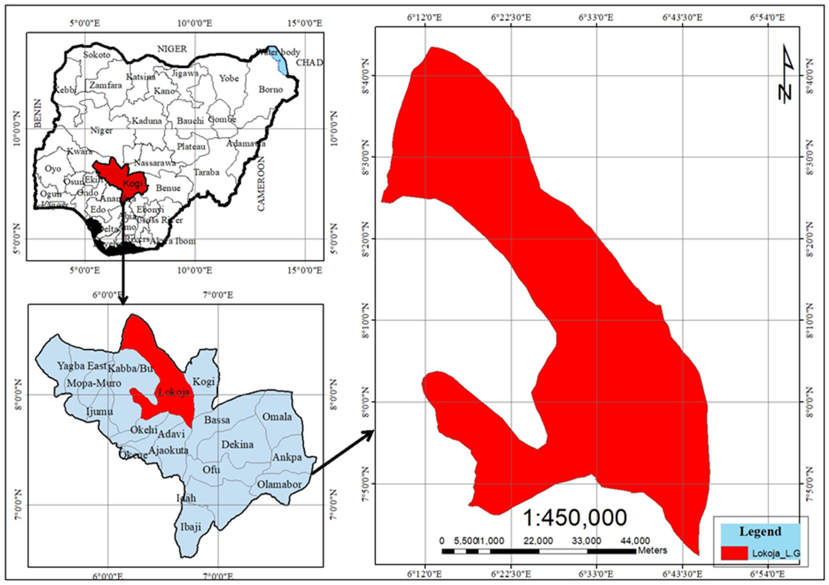
Figure 1 presents the location of the study area, showing the position of Lokoja Local Government Area (LGA) within Kogi State and Nigeria. The figure comprises three panels: (i) the location of Kogi State within Nigeria, (ii) the location of Lokoja LGA within Kogi State, and (iii) the spatial extent of Lokoja LGA with its geographic coordinates and administrative boundary. Lokoja is strategically situated at the confluence of the River Niger and the River Benue, a geographical setting that makes the area highly susceptible to seasonal flooding. Lokoja, the capital of Kogi State, lies at the confluence of the Niger River and Benue River (7°45′–7°52′ N, 6°41′–6°45′ E). This strategic location has shaped its role as a major trade, transport, and administrative hub [29,30].
The Lokoja metropolitan area, comprising the urban core and rapidly expanding peri-urban settlements, had an estimated population of approximately 886,000 in 2024, projected to reach 931,000 by 2025 [36,37]. The city is among the fastest-growing in Africa, with an annual growth rate of about 5.6–5.93% between 2020 and 2025, driven largely by rural–urban migration and its strategic position as a north–south gateway.
Urban growth is characterised by significant in-migration from surrounding rural areas and neighbouring states, supported by opportunities in administration, education (e.g., Federal University Lokoja), trade, and transport. Urban growth has accelerated peri-urban expansion along key corridors—particularly the Abuja–Lokoja highway—and across riverine zones. Informal settlements have expanded notably in areas such as Ganaja, Adankolo, Felele, Lokongoma, and Sarkin Noma. Consistent with broader Nigerian urbanisation trends, this growth is largely unplanned and low-density, placing increasing pressure on flood-prone lowlands, infrastructure, and natural land cover [10,11].
Ecologically, Lokoja lies within the Guinea savanna, characterised by a mosaic of grasslands, scattered trees, and patches of woodland. The landscape includes riparian floodplains, wetlands, and elevated features such as Mount Patti, supporting species such as Parkia biglobosa and Vitellaria paradoxa, as well as diverse bird and aquatic communities [28]. However, these ecosystems are increasingly threatened by land conversion and urban encroachment. Previous study reports substantial vegetation loss and landscape degradation around the Niger–Benue confluence, with implications for ecological connectivity [38].
Lokoja experiences a tropical wet-and-dry climate (Köppen–Geiger Aw), with a rainy season from April to October (1200–1500 mm annually) and a dry season from November to March, often influenced by harmattan winds [39]. Mean temperatures range between 25 °C and 32 °C. Combined with rapid land use change and inadequate drainage, these conditions contribute to recurrent flooding and erosion risks [40].
Recent expansion in areas such as Ganaja, Zango, Adankolo, Felele, Lokongoma, and Kabba Junction has resulted in the conversion of vegetation and wetlands into residential and commercial land uses, intensifying land cover fragmentation and environmental pressure on sensitive landscapes [40].

3.3. Data Acquisition

This study utilised multi-temporal Landsat imagery (2000, 2010, 2020, and 2024; 30 m spatial resolution) obtained from the USGS Earth Explorer to assess land use/land cover and vegetation changes in Lokoja. Dry-season images (December–March) were selected to minimise cloud cover and enhance classification accuracy.
Additional datasets included the following:
  • Shuttle Radar Topography Mission (SRTM, 30 m) for terrain analysis and floodplain delineation;
  • Lokoja LGA shapefiles for administrative boundary definition;
  • Global Forest Change dataset for cross-validation of vegetation dynamics;
  • Field-based GPS points for ground-truthing of land cover and vegetation classes.

3.4. Image Processing and Classification

The authors processed Landsat imagery from Landsat 7 ETM+, Landsat 8 OLI, and Landsat 9 OLI-2 in Google Earth Engine (GEE). All images were filtered by acquisition date and clipped to the Lokoja Local Government Area boundary using the WGS 84 coordinate reference system. Median composites were generated for each study year to reduce cloud contamination, atmospheric noise, and sensor-related inconsistencies, thereby improving temporal comparability.
Cloud-contaminated pixels were minimised using the Landsat Simple Cloud Score algorithm, and all composites were spatially subset to the study area. Spectral indices were derived to enhance land surface discrimination and ecological interpretation. These included the Normalised Difference Vegetation Index (NDVI) for assessing vegetation condition, the Normalised Difference Built-up Index (NDBI) for identifying built-up surfaces, the Bare Soil Index (BSI) for detecting exposed soil and degraded surfaces, and the Normalised Difference Water Index (NDWI) for delineating surface water bodies.
Land use/land cover classification was conducted using a rule-based index-threshold approach implemented in GEE. Threshold values derived from spectral indices were used to classify the landscape into seven categories: built-up area, dense forest, woodland, grassland, sparse vegetation, bare soil, and water bodies. This approach ensured classification consistency across multiple time periods and facilitated the interpretation of land cover dynamics.
The classified maps were subsequently used for spatial analysis and change detection across the study period, providing insights into land cover transitions and broader landscape dynamics within Lokoja LGA. Training samples were selected using field observations, high-resolution imagery, and expert knowledge of the study area to improve class separability and classification reliability.

3.5. Land Use and Land Cover Change Analysis

The authors conducted a land use and land cover (LULC) change analysis to evaluate spatial and temporal landscape dynamics within the Lokoja Local Government Area between 2000 and 2024. Classified maps generated for the four study epochs were used to quantify changes in land cover composition and identify dominant transition patterns over time.
For each study year, the areal extent of the seven land cover classes was calculated in hectares using pixel-based area estimation within Google Earth Engine (GEE). Changes in land cover were assessed by comparing class-wise area statistics across epochs, enabling the identification of increasing, decreasing, and relatively stable land cover categories. This approach provided a consistent evaluation of long-term landscape dynamics without relying solely on post-classification cross-tabulation matrices.
Vegetation dynamics were further assessed using mean Normalised Difference Vegetation Index (NDVI) values computed for each epoch. Temporal NDVI trends provided insights into variations in vegetation condition and landscape productivity, complementing the categorical land cover analysis. Increasing or declining NDVI values were interpreted in relation to observed transitions among dense forest, woodland, grassland, and sparse vegetation classes.
The authors visually examined spatial patterns of change through a comparative analysis of classified maps for 2000, 2010, 2020, and 2024. The various maps facilitated the identification of areas undergoing urban expansion, vegetation degradation, or vegetation recovery. The authors gave particular attention to transitions involving built-up areas, forested landscapes, and bare surfaces, which are strongly associated with population growth, infrastructure development, and land management practices.
The integration of area statistics, NDVI trends, and spatial map comparison provided a robust framework for understanding land cover change processes and their broader ecological implications within Lokoja LGA over the 24-year study period.

3.6. Accuracy Assessment and Validation

Classification accuracy was evaluated using a confusion matrix derived from ground-truth points collected during field surveys and validated with high-resolution imagery. A total of 210 validation points were distributed across the seven land cover classes to ensure adequate class representation and reduce sampling bias.
The classification achieved an overall accuracy of 88.6% and a Kappa coefficient of 0.84, indicating strong agreement between the classifications and the reference datasets. These accuracy levels fall within acceptable standards for Landsat-based land cover classification and are consistent with previous studies employing machine learning and index-based approaches in heterogeneous urban environments. The accuracy assessment confirms the reliability of the classified maps for analysing long-term land cover dynamics, vegetation change, and landscape fragmentation within Lokoja Local Government Area.

3.7. Change Detection and Fragmentation Analysis

Post-classification comparison was employed to detect land cover transitions across four intervals: 2000–2010, 2010–2020, 2020–2024, and the overall 2000–2024 period. Urban expansion rates were computed as annual changes in built-up area. At the same time, vegetation loss and landscape conversion were assessed through transitions from natural land cover classes to built-up and other modified surfaces.
Landscape metrics were computed using PyLandStats to quantify land cover fragmentation at both class and landscape levels. The metrics included the following:
  • Percentage of Landscape (PLAND).
  • Patch Density (PD).
  • Edge Density (ED).
  • Largest Patch Index (LPI).
  • Core Area Metrics.
  • Landscape Shape Index (LSI).
  • Shannon’s Diversity Index (SHDI).
These metrics provided insights into the extent, configuration, and spatial patterns of land cover fragmentation associated with urban expansion in Lokoja Local Government Area.

3.8. Vegetation Health and Ecological Assessment

The author performed an sNDVI time-series analysis to evaluate vegetation health trends from 2000 to 2024. Field-based biodiversity observations (plants, birds, and amphibians) were overlaid with land cover maps to assess how habitat loss and fragmentation influence species distribution and ecosystem quality.

3.9. Data Analysis and Ethical Considerations

Statistical analyses, including Pearson correlation and temporal trend analysis, were conducted in R (version 4.4 series) and Python (version 3.11–3.12 series) to examine relationships among urban expansion, vegetation dynamics, and landscape degradation. All analytical procedures were implemented using reproducible open-source workflows within Jupyter Notebook (version 4.4 series) environments to ensure the transparency, consistency, and replicability of the results.
Field activities adhered to established ethical and environmental research standards, including appropriate data authorisation procedures and minimal disturbance to vegetation and ecological features during GPS data collection and field validation exercises.

4. Results and Discussion

4.1. Urban Expansion Trajectory: Non-Linear Growth & Consolidation

To address Objective 1, this study mapped and analysed the spatio-temporal dynamics of urban expansion in Lokoja between 2000 and 2024. The results reveal a non-linear three-phase growth trajectory characterised by rapid outward expansion, temporary contraction, and subsequent urban densification.
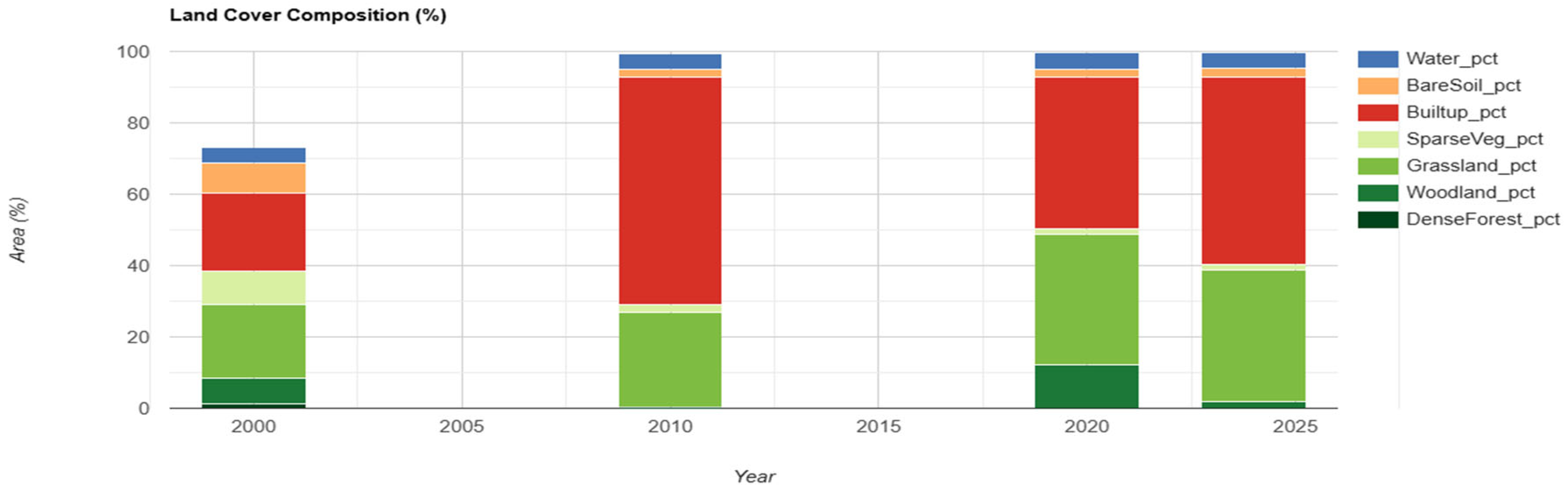
Figure 2 illustrates the changing land cover structure of Lokoja between 2000 and 2024. Built-up areas expanded substantially from 6668 ha in 2000 to 19,371 ha in 2010, declined to 12,883 ha in 2020, and increased again to 15,985 ha in 2024, representing an overall increase of approximately 140% during the study period. In contrast, dense forest cover declined almost completely from 373 ha to 1 ha, while woodland decreased markedly from 2207 ha to 577 ha. Grassland fluctuated across the study years but ultimately increased to 9224 ha in 2024, suggesting areas of secondary vegetation regeneration. Sparse vegetation declined to 143 ha, whereas bare soil reduced from 2558 ha in 2000 to 696 ha in 2024 following a peak in 2010, indicating partial vegetation recovery on previously exposed surfaces. Water bodies remained relatively stable throughout the period at approximately 1360 ha.
The trajectory of urban development can be grouped into three major phases. Phase I (2000–2010) was characterised by rapid urban sprawl, during which built-up areas increased by about 190% (approximately 1270 ha/year). Urban growth was concentrated around the Niger–Benue confluence and along major transport corridors, producing a highly centralised urban form. This was reflected in the increase in the Largest Patch Index (LPI) to 42%, indicating strong urban coalescence. Phase II (2010–2020) was a period of consolidation and relative slowdown, during which the built-up area declined by approximately 33%. This reduction may be associated with redevelopment processes, slum clearance initiatives, economic restructuring, and broader socio-economic disruptions during the COVID-19 period. During this phase, patch density increased to 21.8 patches per 100 ha, suggesting increasing spatial fragmentation within the urban landscape. Phase III (2020–2024) marked a period of renewed urban expansion characterised by densification and hyper-fragmentation. Although the built-up area rebounded to 15,985 ha (about 776 ha/year), the number of urban patches increased sharply to 3887. In comparison, mean patch size declined to 2.4 ha, indicating intensified infilling, subdivision of open spaces, and reduction in green interstitial areas.
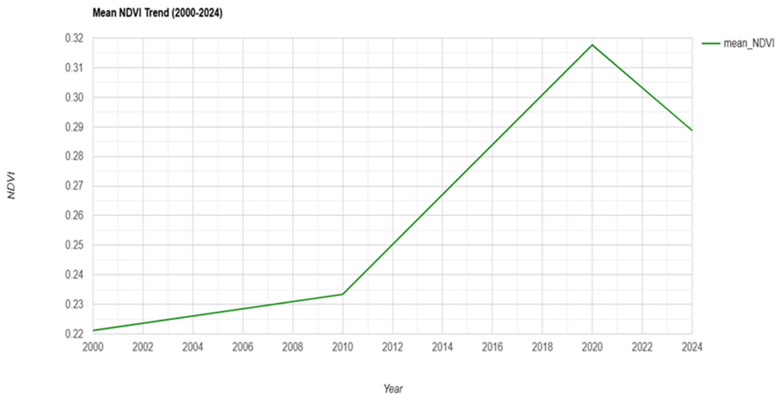
Overall, Lokoja’s urban growth trajectory demonstrates a transition from rapid outward sprawl (2000–2010) to consolidation (2010–2020) and subsequently to fragmented urban densification (2020–2024). The near-total loss of dense forest cover (−99.7%) and the sharp increase in patch numbers underscore growing ecological pressure on natural landscapes. Although temporary grassland expansion contributed to a short-term improvement in NDVI values from 0.22 to 0.32, the subsequent decline to 0.29 by 2024 suggests increasing ecological stress and declining vegetation quality under sustained urban expansion.
Figure 3 presents the mean NDVI trend, showing a gradual improvement in vegetation health until 2020, followed by a mild decline under continued urban pressure.

4.2. Spatial Patterns of Expansion

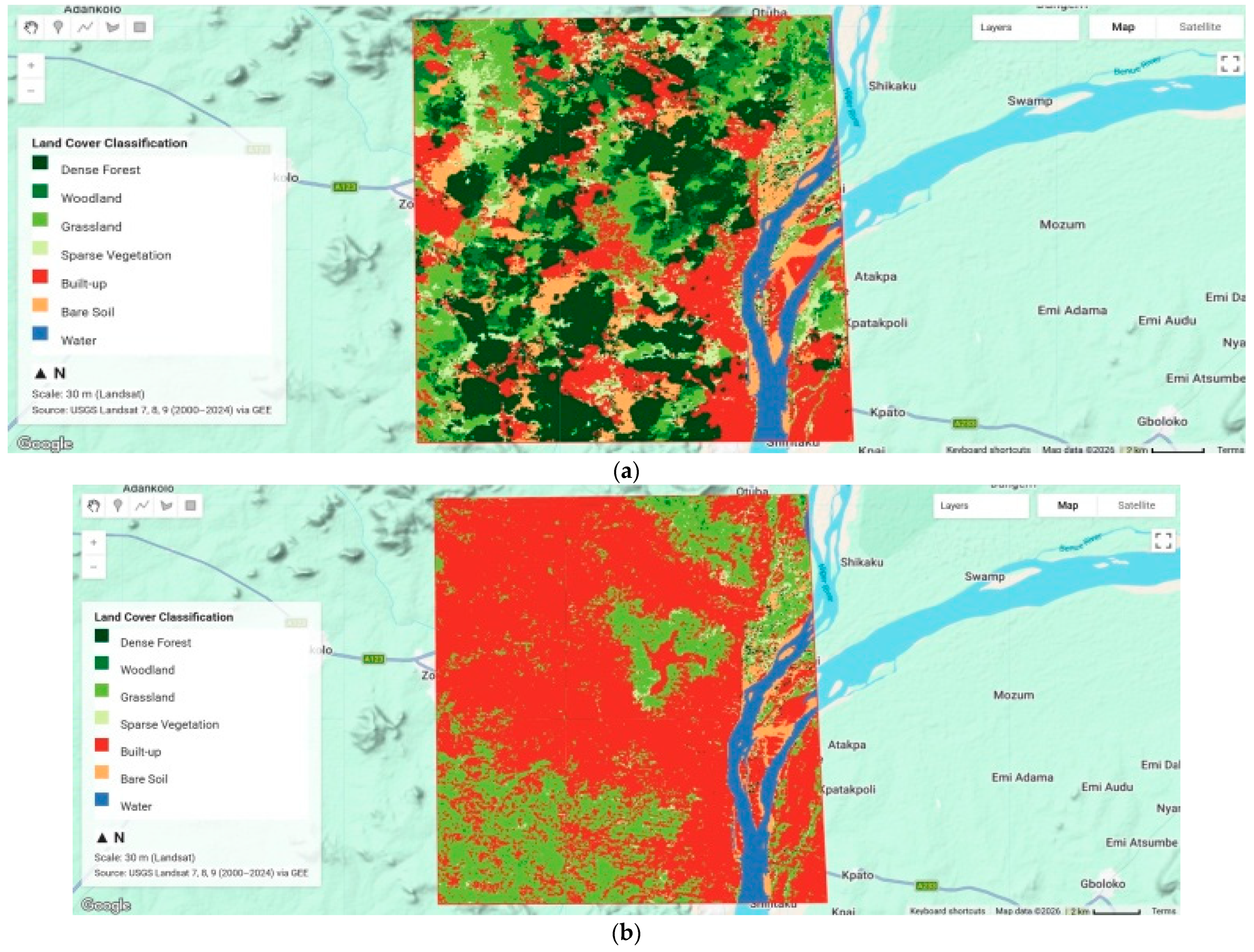
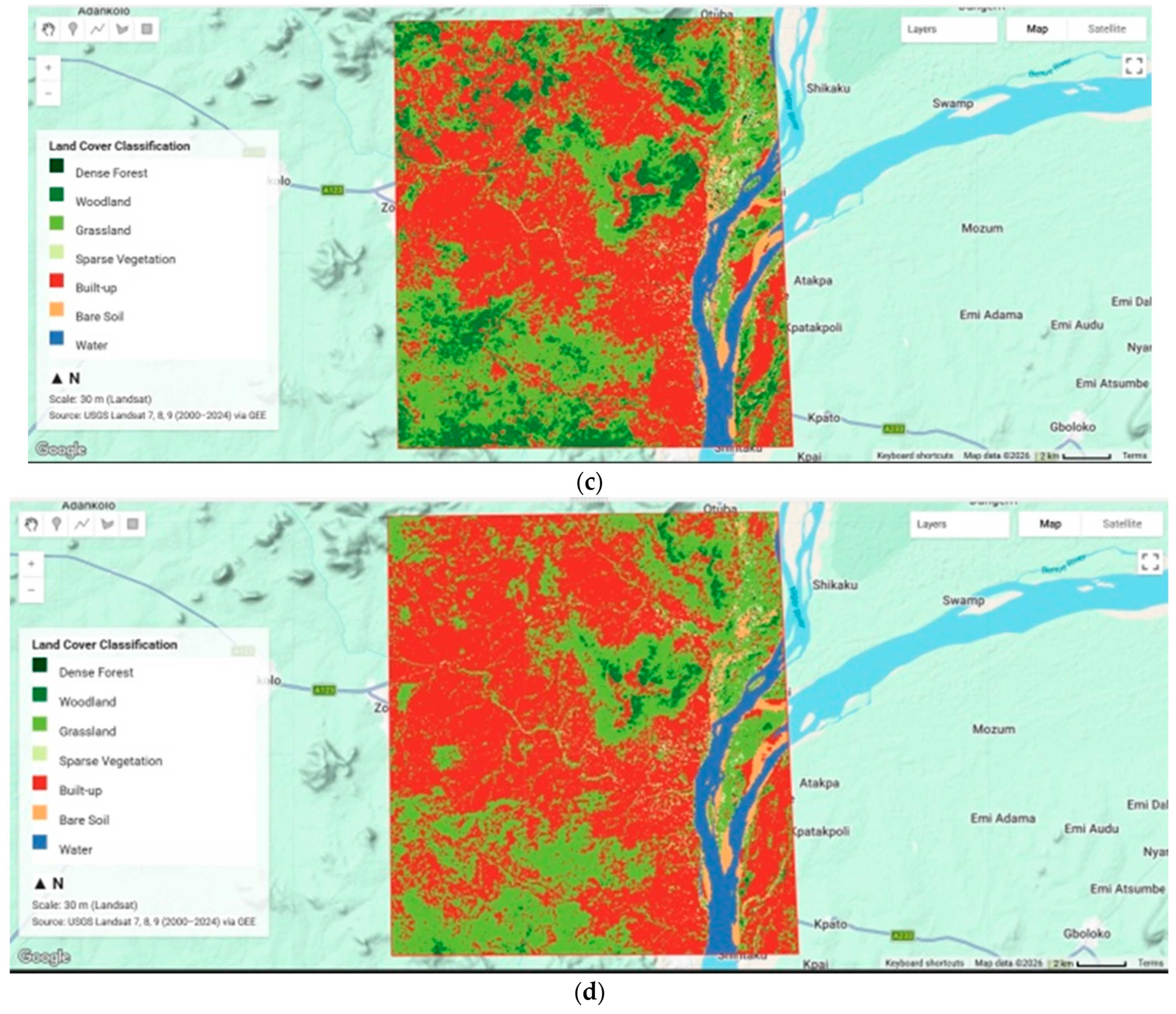
Spatial analysis (Figure 4a,b) indicates that more than 60% of newly developed built-up areas between 2000 and 2010 were concentrated within floodplain environments, particularly in Ganaja, Felele, and Adankolo. This trend reflects the continued expansion of settlements into environmentally sensitive and flood-prone zones. Ribbon development was evident along the Abuja–Lokoja highway and adjacent river corridors, while upland areas such as Mount Patti remained sparsely settled, with land use largely limited to quarrying activities.
Landscape structure changed markedly over the study period. Edge density increased from 36.2 to 79.9 m/ha (a 121% rise), indicating heightened fragmentation of natural land cover types. This transformation is associated with increased environmental pressures, including intensified surface runoff, urban heat island effects, and the spread of invasive species. In addition, interior green spaces—defined as areas located more than 100 m from the nearest edge—declined from 4504 ha (23%) to 3927 ha (14%), falling below commonly accepted ecological viability thresholds for sustaining stable natural land cover systems.
These findings indicate that urban expansion in Lokoja is both topographically constrained and hydrologically vulnerable, with increasing encroachment into floodplain areas and the fragmentation of natural land cover types posing significant ecological risks.

4.3. Habitat Types and Ecological Roles in Lokoja Metropolis

To address Objective 2, this study identified and characterised major natural land cover types and their associated ecological functions. Lokoja’s ecological landscape comprises six primary land cover types, each supporting distinct vegetation assemblages and ecosystem services, which are increasingly under pressure from urban expansion (Table 1).
Riverine and riparian zones, dominated by gallery forest species such as Ficus spp. and Syzygium guineense, function as critical flood buffers, pollutant filters, and wildlife corridors. However, these natural land cover types are under intense pressure from residential encroachment and sand mining. Wetlands and floodplains, characterised by reeds (Phragmites spp.) and aquatic vegetation such as water lilies, play a key role in hydrological regulation and biodiversity support but are increasingly being reclaimed for settlement and agriculture.
Savanna woodlands, dominated by Vitellaria paradoxa and Parkia biglobosa, provide essential ecosystem services including non-timber forest products and carbon storage. These areas, however, are undergoing degradation due to fuelwood extraction and quarrying activities. Grasslands and cultivated lands contribute to soil stabilisation and sustain agro-pastoral systems. At the same time, rocky outcrops support xerophytic vegetation and localised endemic species, both of which are threatened by slope modification and mining.
Urban green spaces—including roadside vegetation, institutional gardens, and sacred groves—offer important microclimatic regulation and ecological benefits but are frequently neglected or converted to built-up areas. Collectively, these natural land cover types, validated through field surveys (2023–2024), constitute the ecological infrastructure of Lokoja. However, they are increasingly fragmented and functionally degraded due to unplanned urban expansion.

4.4. Quantifying Habitat Loss and Fragmentation Induced by Urban Growth

Addressing Objective 3, the study quantified net loss and fragmentation of natural land cover types using Landsat-derived land use/land cover (LULC) data and FRAGSTATS metrics (Table 2 and Table 3). Although the total extent of natural land cover in Lokoja Metropolis increased marginally from 8925 ha in 2000 to 9946 ha in 2024 (an increase of 11.4%), this apparent gain conceals substantial ecological degradation.
Specifically, high-quality vegetation classes experienced pronounced declines: dense forest cover decreased by 99.7%, woodland by approximately 74%, and sparse vegetation by 87%. In contrast, grassland expanded by 77.1%, largely reflecting secondary succession on previously degraded or cleared land rather than genuine ecological recovery. Overall, these changes correspond to an estimated net loss of approximately 3000 ha of primary vegetation (Table 2).
These trends indicate a significant shift in landscape composition, characterised by the replacement of structurally complex, ecologically stable vegetation with simpler, more degraded land cover types. The results underscore the importance of moving beyond areal extent alone to assess ecological integrity, as increases in total vegetation cover may mask underlying losses in quality, function, and biodiversity.
Fragmentation intensified markedly across all landscape metrics. Edge density more than doubled from 36.2 to 79.9 m/ha (+121%), while patch density increased from 6.74 to 13.63 patches per 100 ha, indicating a progressively dissected and unstable landscape. As natural land cover types are subdivided into smaller, more irregular patches, edge effects are amplified, exposing ecosystems to elevated temperatures, increased surface runoff, and heightened susceptibility to invasive species.
Core areas—defined as portions of natural land cover located beyond 100 m from patch edges—declined from 4504 ha (≈23% of the landscape) in 2000 to 3927 ha (≈13.8%) in 2024. This reduction places the system below the 15–20% threshold commonly associated with the long-term persistence of forest-dependent taxa [26,44]. The loss of structurally complex vegetation (notably dense forest and woodland) therefore signals a transition from gradual degradation to a more precarious ecological state, with increased risks of local population declines and extirpations.
Connectivity metrics show a concurrent collapse in landscape cohesion. Effective mesh size rose transiently to 4448 ha in 2020, likely reflecting short-term urban consolidation, but declined sharply to 557 ha by 2024, indicating severe fragmentation and loss of functional connectivity. Mean patch size of natural land cover decreased from ~50 ha to 2.4 ha, accompanied by increased shape complexity, further constraining ecological processes and species movement.
These trends are consistent with, but exceed, fragmentation patterns reported for comparable sub-Saharan African cities. Built-up area expanded by ~140% (6668 → 15,985 ha), surpassing typical rates of 80–120% [1,2]. While cities such as Benin City [45] and Accra [46] exhibit similar fragmentation trajectories, the magnitude of edge density increase in Lokoja (+121%) is higher than reported for Jos [47] and Makurdi [22]. This accelerated landscape transformation is reinforced by Lokoja’s confluence topography and linear expansion along the A2 corridor, compounded by weak land use governance [48]. Collectively, these dynamics position Lokoja as a critical case for examining ecological thresholds and fragmentation-driven risks in rapidly urbanising riverine systems across sub-Saharan Africa [28].
Table 3 presents FRAGSTATS class-level metrics that capture the evolving spatial structure of built-up land in Lokoja between 2000 and 2024, indicating a transition from relatively cohesive expansion to pronounced fragmentation. Urban land extent peaked in 2020 (13,113 ha; 52.7% of the landscape), characterised by a dominant connected core (largest patch index = 42.2%), reflecting spatial coalescence along major transport corridors and the Niger–Benue confluence. By 2024, although total built-up area declined to 9403 ha (33.0%), the number of patches more than doubled (from 1719 to 3887), increasing patch density to 13.63 per 100 ha and reducing the largest patch index to 12.4%. This pattern indicates the disintegration of previously consolidated urban cores.
Fragmentation is further evidenced by a 121% increase in edge density (36.2 to 79.9 m/ha), expanding urban–natural land cover interfaces and intensifying edge-related processes, including localised heat accumulation, increased surface runoff, and ecological stress. Core urban areas—defined as zones located more than 100 m from patch edges—declined sharply to 3927 ha (13.8%), while effective mesh size decreased from 4448 ha to 557 ha, reflecting substantial loss of landscape connectivity. In addition, the landscape shape index increased to 85.4, indicating greater geometric complexity and irregularity of urban patches, consistent with ribbon and leapfrog development patterns.
Overall, these metrics demonstrate that recent urban growth in Lokoja has shifted toward a highly fragmented, edge-dominated configuration. This transformation increases pressure on adjacent natural land cover types and presents significant challenges for infrastructure provision, flood regulation, and sustainable urban management.

5. Conclusions and Recommendations

5.1. Summary of Key Findings

This study examined the impacts of urban expansion on natural land cover types in Lokoja Metropolis, Nigeria, over the period 2000–2024. Using multi-temporal satellite imagery, machine learning-based land use/land cover (LULC) classification, landscape metrics, and field-based validation, this study provides a comprehensive spatio-temporal assessment of urban growth patterns and their ecological implications. The results reveal a non-linear urbanisation trajectory, characterised by rapid outward expansion between 2000 and 2010, relative consolidation from 2010 to 2020, and renewed intensification accompanied by pronounced fragmentation after 2020. Overall, the built-up area increased by approximately 140% (from ~6700 ha to ~16,000 ha).
Despite a marginal increase in total natural land cover extent, the composition and quality of these systems declined significantly. Dense forest cover decreased by 99.7%, woodland by nearly 74%, and an estimated 3000 ha of primary vegetation were lost. The observed increase in grassland cover reflects secondary succession on degraded land rather than substantive ecological recovery. These shifts indicate a transition from structurally complex and functionally stable vegetation to simpler, more degraded land cover types.
Landscape fragmentation intensified substantially over the study period. Edge density increased by over 121% (from 36.2 to 79.9 m/ha), while the proportion of core areas—defined as natural land cover located more than 100 m from edges—declined from 23% to 13.8% of the total landscape. This reduction falls below the 15–20% threshold considered critical for maintaining the long-term viability of many species [26,44]. The loss of core areas and increasing patch isolation reflect a marked decline in landscape connectivity and ecological integrity.
Six major natural land cover types were identified: riverine gallery forests, floodplain wetlands, savanna woodlands, grasslands, rocky outcrops, and urban green spaces, each providing essential ecosystem services, including flood regulation, biodiversity support, and microclimate moderation. However, all are increasingly under pressure from urban encroachment, sand mining, fuelwood extraction, quarrying, and floodplain reclamation.
Collectively, these findings position Lokoja as a representative case of the ecological pressures confronting rapidly urbanising riverine cities in sub-Saharan Africa, where population growth and administrative expansion often outpace land use planning and environmental governance. The resulting landscape transformation has significant implications for flood risk, urban heat dynamics, biodiversity conservation, and the long-term sustainability of ecosystem services.

5.2. Conclusions

Lokoja’s predominantly unplanned urban expansion has exerted substantial, long-term pressure on its natural land cover, driving several ecologically valuable systems toward functional degradation and weakening the city’s overall ecological resilience. The near-complete loss of dense forest and the pronounced fragmentation of remaining natural land cover underscore the unsustainability of current development patterns. Without timely and coordinated intervention, the city faces increasing risks of biodiversity loss, heightened hydrological vulnerability, and declining environmental quality for its residents.
However, evidence of intermittent consolidation phases and localised secondary vegetation regrowth suggests that these trends are not irreversible. With appropriate planning and management, it is possible to stabilise and restore elements of the urban ecological system. By integrating remote sensing analysis with field-based ecological validation, this study provides a practical and transferable framework for balancing urban growth with the conservation of natural land cover in comparable mid-sized cities across sub-Saharan Africa.

5.3. Recommendations

To promote sustainable urban development while safeguarding Lokoja’s remaining natural capital, the following evidence-based measures are proposed:
(a)
Floodplain and riparian protection: Restrict new development in low-lying flood-prone zones (e.g., <10 m elevation) and enforce a minimum 100 m buffer along the Niger, Benue, and associated tributaries to maintain natural flood regulation functions and ecological corridors.
(b)
Targeted ecological restoration: Prioritise the rehabilitation of at least 500 ha of degraded natural land cover, particularly riverine gallery forests and savanna woodlands, along strategic corridors using indigenous species and community-based nursery systems to enhance landscape connectivity.
(c)
Urban greening requirements: Mandate a minimum of 20% tree canopy cover in new residential and commercial developments, supported by incentives for the retention of mature trees and the integration of green infrastructure (e.g., urban parks, green roofs, and street vegetation).
(d)
Community-based conservation: Recognise and protect culturally significant sites (e.g., sacred groves) and remnant urban green spaces through participatory monitoring frameworks that incorporate local knowledge into planning and management processes.
(e)
Strengthened spatial planning and governance: Update the Lokoja Master Plan to incorporate GIS-based zoning informed by fragmentation metrics and flood risk maps, and establish a dedicated inter-agency Urban Ecology Unit to oversee compliance, monitoring, and ecological performance indicators.
Implementation of these measures would help arrest the ongoing degradation of natural land cover types, enhance ecosystem connectivity, and strengthen resilience to climate-related hazards, including flooding and urban heat stress. In addition, they would contribute to improved public health outcomes and the preservation of ecosystem services that underpin local livelihoods. Collectively, these actions address the observed patterns of urban expansion, fragmentation, and ecological decline, while providing a coherent framework for integrating environmental considerations into urban planning. The framework advanced in this study is both transferable and scalable, offering a practical model for other mid-sized, ecologically sensitive cities in sub-Saharan Africa facing similar urbanisation pressures and environmental risks.

Author Contributions

Conceptualization, H.O.J.-N., N.I.N. and R.O.J.; methodology, H.O.J.-N., N.I.N. and R.O.J.; Software, N.I.N. and N.G.J.; validation, H.O.J.-N., N.I.N. and N.G.J.; formal analysis, H.O.J.-N., R.O.J., N.G.J. and E.M.; Investigation, H.O.J.-N., N.I.N., E.M. and O.R.O.; Resources, N.G.J., E.M. and O.R.O.; data curation, N.I.N., R.O.J. and E.M.; writing—original draft preparation, H.O.J.-N., N.I.N. and R.O.J.; writing—review and editing, H.O.J.-N., N.I.N., R.O.J., N.G.J., E.M. and O.R.O.; visualization, N.I.N., E.M. and O.R.O.; supervision, H.O.J.-N.; project administration, H.O.J.-N., N.G.J. and E.M. All authors have read and agreed to the published version of the manuscript.

Funding

This research received no external funding.

Institutional Review Board Statement

Not applicable.

Informed Consent Statement

Not applicable.

Data Availability Statement

The data used in this study come from a combination of publicly available and restricted sources. Satellite imagery (Sentinel-2 and Landsat) was obtained from open-access repositories provided by the European Space Agency (ESA) and the United States Geological Survey (USGS). The geospatial datasets generated during the analysis, including processed maps and model outputs, are available from the corresponding author upon reasonable request. Due to privacy and ethical considerations, survey data from participants are not publicly shared; however, anonymised versions may be made available upon reasonable request.

Acknowledgments

The authors sincerely appreciate the support of colleagues and field assistants who contributed to data collection and ground-truthing activities. We also acknowledge the European Space Agency (ESA) and the United States Geological Survey (USGS) for providing access to the open-source satellite imagery used in this study. During the preparation of this manuscript, the authors used AI to support language refinement, structuring, and editing. All outputs were carefully reviewed and revised, and the authors take full responsibility for the content of this publication.

Conflicts of Interest

The authors declare no conflicts of interest associated with this study. The authors did not receive external funding.

References

  1. Seto, K.C.; Güneralp, B.; Hutyra, L.R. Global forecasts of urban expansion to 2030 and direct impacts on biodiversity and carbon pools. Proc. Natl. Acad. Sci. USA 2012, 109, 16083–16088. [Google Scholar] [CrossRef] [PubMed]
  2. Angel, S.; Parent, J.; Civco, D.L.; Blei, A.; Potere, D. The dimensions of global urban expansion: Estimates and projections for all countries, 2000–2050. Prog. Plan. 2011, 75, 53–107. [Google Scholar] [CrossRef]
  3. United Nations Human Settlements Programme (UN-Habitat). World Cities Report 2016: Urbanisation and Development—Emerging Futures; UN: Geneva, Switzerland, 2016. [Google Scholar]
  4. Grimm, N.B.; Faeth, S.H.; Golubiewski, N.E.; Redman, C.L.; Wu, J.; Bai, X.; Briggs, J.M. Global change and the ecology of cities. Science 2008, 319, 756–760. [Google Scholar] [CrossRef] [PubMed]
  5. Elmqvist, T.; Fragkias, M.; Goodness, J.; Güneralp, B.; Marcotullio, P.J.; McDonald, R.I.; Parnell, S.; Schewenius, M.; Sendstad, M.; Seto, K.C.; et al. Urbanization, Biodiversity and Ecosystem Services: Challenges and Opportunities; Springer: Berlin, Germany, 2013. [Google Scholar] [CrossRef]
  6. McDonald, R.I.; Marcotullio, P.J.; Güneralp, B. Urbanization and Global Trends in Biodiversity and Ecosystem Services. In Urbanization, Biodiversity and Ecosystem Services: Challenges and Opportunities; Elmqvist, T., Fragkias, M., Goodness, J., Güneralp, B., Marcotullio, P.J., McDonald, R.I., Parnell, S., Schewenius, M., Sendstad, M., Seto, K.C., et al., Eds.; Springer: Berlin, Germany, 2013; pp. 31–52. [Google Scholar] [CrossRef]
  7. Chapin, F.S., III; Zavaleta, E.S.; Eviner, V.T.; Naylor, R.L.; Vitousek, P.M.; Reynolds, H.L.; Hooper, D.U.; Lavorel, S.; Sala, O.E.; Hobbie, S.E.; et al. Consequences of changing biodiversity. Nature 2000, 405, 234–242. [Google Scholar] [CrossRef] [PubMed]
  8. Kabisch, N.; Qureshi, S.; Haase, D. Human–environment interactions in urban green spaces—A systematic review of contemporary issues and prospects for future research. Environ. Impact Assess. Rev. 2015, 50, 25–34. [Google Scholar] [CrossRef]
  9. Korah, A.I.; Koch, J.A.M.; Wimberly, M.C. Understanding urban growth modelling in Africa: A review. Landsc. Urban Plan. 2024, 146, 104734. [Google Scholar] [CrossRef]
  10. Organisation for Economic Co-operation and Development/Sahel and West Africa Club. Africa’s Urbanisation Dynamics 2025: Planning for Urban Expansion; OECD Publishing: Paris, France, 2025. [Google Scholar]
  11. Avis, W.R. Urban Expansion in Nigeria. 2019. Available online: https://gsdrc.org/wp-content/uploads/2019/11/692_Urban_Expansion_of_Nigerian_Cities.pdf (accessed on 15 November 2025).
  12. Bolund, P.; Hunhammar, S. Ecosystem services in urban areas. Ecol. Econ. 1999, 29, 293–301. [Google Scholar] [CrossRef]
  13. Alabi, M.O. Urban sprawl, pattern, and measurement in Lokoja, Nigeria. Theor. Empir. Res. Urban Manag. 2009, 4, 158–164. [Google Scholar]
  14. Ukoje, J.E. Impacts of rapid urbanisation in the urban fringe of Lokoja, Nigeria. J. Geogr. Reg. Plan. 2016, 9, 185–194. [Google Scholar] [CrossRef]
  15. Akubia, J.E.K.; Bruns, A. Unravelling the frontiers of urban growth: Spatio-temporal dynamics of land-use change and urban expansion in Greater Accra Metropolitan Area, Ghana. Land 2019, 8, 131. [Google Scholar] [CrossRef]
  16. Adelekan, I.O. Flood risk management in the coastal city of Lagos, Nigeria. J. Flood Risk Manag. 2016, 9, 255–264. [Google Scholar] [CrossRef]
  17. Adegun, O.B. Green infrastructure in informal settlements: A spatial planning approach in Lagos, Nigeria. Urban Forum 2019, 30, 437–456. [Google Scholar]
  18. Simkin, R.D.; Seto, K.C.; McDonald, R.I.; Jetz, W. Biodiversity impacts and conservation implications of urban land expansion projected to 2050. Proc. Natl. Acad. Sci. USA 2022, 119, e2117297119. [Google Scholar] [CrossRef] [PubMed]
  19. Oyalowo, B. Implications of urban expansion: Land, planning and housing in Lagos. Build. Cities 2022, 3, 692–708. [Google Scholar] [CrossRef]
  20. Oyinloye, M.A.; Kufoniyi, O. Analysis of land use/landcover change and urban expansion in Akure, Nigeria. J. Innov. Res. Eng. Sci. 2011, 2, 180–189. [Google Scholar]
  21. Iortyom, E.T.; Semaka, J.T.; Abawua, J.I. Spatial expansion of urban activities and agricultural lands encroachment in Makurdi Metropolis, Benue State, Nigeria (1999–2012). Eur. J. Environ. Earth Sci. 2020, 1, 25–33. [Google Scholar] [CrossRef]
  22. Shabu, T.; Fate, S.; Ukula, M.K. Impact of urbanization on agricultural land in Makurdi Local Government Area of Benue State, Nigeria. NASS J. Agric. Sci. 2021, 3, 21–28. [Google Scholar] [CrossRef]
  23. Wizor, C.H.; Wali, E. Geo-spatial analysis of urban wetland loss in Obio/Akpor Local Government Area, Rivers State, Nigeria. Asian J. Geogr. Res. 2020, 3, 35–48. [Google Scholar] [CrossRef]
  24. Tijani, M.N.; Olaleye, A.O.; Olubanjo, O.O. Impact of urbanisation on wetland degradation: A case study of Eleyele Wetland, Ibadan, South-West Nigeria. Coler. Proc. 2012, 2, 434–456. [Google Scholar]
  25. Gilbert, K.M.; Shi, Y.S. Land-use/land-cover change detection in Lagos City, Nigeria, using remote sensing and GIS. Adv. Remote Sens. 2023, 12, 145–165. [Google Scholar] [CrossRef]
  26. Fahrig, L. Effects of habitat fragmentation on biodiversity. Annu. Rev. Ecol. Evol. Syst. 2003, 34, 487–515. [Google Scholar] [CrossRef]
  27. McGarigal, K.; Cushman, S.A.; Neel, M.C.; Ene, E. FRAGSTATS: Spatial Pattern Analysis Program for Categorical Maps. 2002. Available online: https://fragstats.org (accessed on 15 October 2025).
  28. Ifatimehin, O.O.; Ufuah, M.E. An analysis of urban expansion and loss of vegetation cover in Lokoja using GIS techniques. Zaria Geogr. 2006, 17, 28–36. [Google Scholar]
  29. Adeoye, N.O. Spatio-temporal analysis of land use/cover change of Lokoja—A confluence town. J. Geogr. Geol. 2012, 4, 40–51. [Google Scholar] [CrossRef]
  30. Turner, B.L.; Meyer, W.B.; Skole, D.L. Global land-use/land-cover change: Towards an integrated study. Ambio 1994, 23, 91–95. [Google Scholar]
  31. Jenks, M.; Burton, E.; Williams, K. (Eds.) The Compact City: A Sustainable Urban Form; Routledge: Abingdon, UK, 1996. [Google Scholar]
  32. McDonnell, M.J.; Pickett, S.T.A. Ecosystem structure and function along urban–rural gradients: An unexploited opportunity for ecology. Ecology 1990, 71, 1232–1237. [Google Scholar] [CrossRef]
  33. Forman, R.T.T. Land Mosaics: The Ecology of Landscapes and Regions; Cambridge University Press: Cambridge, UK, 1995. [Google Scholar]
  34. United Nations Human Settlements Programme (UN-Habitat). World Cities Report 2022: Envisaging the Future of Cities; UN: Geneva, Switzerland, 2023. [Google Scholar]
  35. MacroTrends. Lokoja, Nigeria, Metro Area Population 1950–2025. Available online: https://www.macrotrends.net/global-metrics/cities/206383/lokoja/population (accessed on 27 December 2025).
  36. World Population Review. Lokoja Population 2025. Available online: https://worldpopulationreview.com/cities/nigeria/lokoja (accessed on 27 December 2025).
  37. White, F. The Vegetation of Africa: A Descriptive Memoir to Accompany the UNESCO/AETFAT/UNSO Vegetation Map of Africa; UNESCO: Paris, France, 1983. [Google Scholar]
  38. Peel, M.C.; Finlayson, B.L.; McMahon, T.A. Updated world map of the Köppen-Geiger climate classification. Hydrol. Earth Syst. Sci. 2007, 11, 1633–1644. [Google Scholar] [CrossRef]
  39. Oyebande, L. The Effects of Reservoir Operation and Management on the Hydrology and Water Resources of the Niger Basin; Kainji Lake Research Institute: New Bussa, Nigeria, 1985. [Google Scholar]
  40. Adelekan, I.O. Urban dynamics, everyday hazards, and disaster risks in Ibadan, Nigeria. Environ. Urban. 2020, 32, 213–232. [Google Scholar] [CrossRef]
  41. Ifatimehin, O.O.; Ujoh, F.; Magaji, J.Y. An evaluation of the effect of land use/cover change on the surface temperature of Lokoja town, Nigeria. Afr. J. Environ. Sci. Technol. 2009, 3, 86–90. [Google Scholar]
  42. Onyekwelu, J.C.; Agbelade, A.D.; Stimm, B.; Mosandl, R. Role of sacred groves in southwestern Nigeria in biodiversity conservation, biomass and carbon storage. Environ. Monit. Assess. 2024, 196, 269. [Google Scholar] [CrossRef] [PubMed]
  43. National Planning Commission. National Development Plan (2021–2025): Volume 1. 2021. Available online: https://nigeriareposit.nln.gov.ng/items/1e1972a6-84c2-4465-949d-7ce24834e0b2 (accessed on 21 October 2025).
  44. Andrén, H. Effects of habitat fragmentation on birds and mammals in landscapes with different proportions of suitable habitat: A review. Oikos 1994, 71, 355–366. [Google Scholar] [CrossRef]
  45. Ogunbodede, E.F.; Balogun, T.F. Landscape fragmentation and urban expansion in Benin City, Nigeria: A remote sensing and GIS approach. Int. J. Sci. Eng. Res. 2013, 4, 734–758. [Google Scholar]
  46. Asabere, S.B.; Acheampong, R.A.; Ashiagbor, G.; Beckers, S.C.; Keck, M.; Erasmi, S.; Schanze, J.; Sauer, D. Urbanization, land use transformation and spatio-environmental impacts: Analyses of trends and implications in major metropolitan regions of Ghana. Land Use Policy 2020, 96, 104707. [Google Scholar] [CrossRef]
  47. Akintunde, J.A.; Ojo, O.B.; Afolabi, Y.D. Urban expansion and loss of agricultural land in Jos Metropolis, Nigeria. J. Environ. Manag. Tour. 2016, 7, 258–269. [Google Scholar]
  48. United Nations Human Settlements Programme (UN-Habitat). Climate Resilience and Urban Development in Africa. 2022. Available online: https://unhabitat.org (accessed on 21 October 2025).
Figure 1. Location map of the study area showing Kogi State in Nigeria, Lokoja Local Government Area in Kogi State, and the spatial extent of Lokoja LGA used for the study. (Source: GIS Laboratory, Federal University, Lokoja, 2025).
Biosphere 02 00006 g001
Figure 2. Land Cover Change (2000–2024).
Biosphere 02 00006 g002
Figure 3. Mean NDVI Trend (2000–2024).
Biosphere 02 00006 g003
Figure 4. The spatial pattern of expansion: (a) Lokoja LULC 2000, (b) Lokoja LULC 2010, (c) Lokoja LULC 2020, and (d) Lokoja LULC 2024.
Biosphere 02 00006 g004aBiosphere 02 00006 g004b
Table 1. Habitat Types, Dominant Vegetation, and Primary Urban Threats in Lokoja Metropolis, Nigeria.
Habitat TypeDominant VegetationMajor Threat from Urban
Expansion
Source(s)
Riverine & Riparian ZonesGallery forests (Ficus spp., Syzygium guineense), raffia palm (Raphia hookeri), aquatic grasses (Echinochloa pyramidalis, Vossia cuspidata)Residential encroachment, sand mining, surface runoff pollution, and riverbank destabilisation[30,41]
Wetlands & FloodplainsReeds (Phragmites australis), sedges (Cyperus papyrus), water lilies (Nymphaea lotus), floating grassesLand reclamation for housing, floodplain agriculture, solid waste dumping, and altered hydrology[23,29]; Field surveys (2023–2024).
Savanna WoodlandVitellaria paradoxa (shea), Parkia biglobosa (locust bean), Isoberlinia doka, Daniellia oliveri, Detarium microcarpumDeforestation for fuelwood/charcoal, road infrastructure, seasonal bush burning, and quarrying[30,38,42]; Field surveys (2023–2024).
Grassland & FarmlandsSecondary grasses (Andropogon gayanus, Hyparrhenia rufa), shrubs, staple crops (yams, cassava, maise)Settlement sprawl, intensive cultivation, soil compaction, agrochemical runoff[22,30]
Rocky Outcrops & Hill HabitatsSparse xerophytic shrubs (Euphorbia kamerunica, Combretum collinum), lichens, grasses; Mount Patti vegetationGranite quarrying, slope modification for construction/tourism, and gully erosion[29,38] Field observation (2024)
Urban Green Spaces (modified habitats)Roadside trees (Azadirachta indica, Delonix regia), institutional gardens, sacred groves, remnant patchesConversion to built-up land, neglect of urban forestry, air/noise pollution[42,43]
Table 2. Natural Habitat.
YearBare Soil (ha)Built-Up (ha)Dense Forest (ha)Grassland (ha)Sparse Vegetation (ha)Water (ha)Woodland (ha)Mean NDVI
20002558.036667.73373.675207.431137.481359.692206.820.2211
2010653.5819,371.040.007763.75188.961359.6952.350.2334
2020691.7112,883.3315.425571.02198.031359.693689.840.3177
2024695.9715,984.611.249224.46143.321359.69576.910.2887
Table 3. FRAGSTATS class-level metrics for the dominant urban land cover class in Lokoja, Nigeria (2000–2024).
YearTotal Area (ha)Proportion of Landscape (%)Number of PatchesPatch Density (/100 ha)Largest Patch Index (%)Edge Density (m/ha)Total Core Area (ha)Core Area Proportion of Landscape (%)Landscape Shape IndexEffective Mesh Size (ha)
20006793.5634.1513406.747.2136.194503.6922.6438.68167.68
20107920.6326.4520416.8112.7957.123994.6513.3461.32559.88
202013,113.1852.7217196.9142.2358.188826.4835.4949.524448.44
20249403.2932.98388713.6312.4079.913926.6113.7785.39557.44
Disclaimer/Publisher’s Note: The statements, opinions and data contained in all publications are solely those of the individual author(s) and contributor(s) and not of MDPI and/or the editor(s). MDPI and/or the editor(s) disclaim responsibility for any injury to people or property resulting from any ideas, methods, instructions or products referred to in the content.