Proceeding Paper

Urban Resilience and Disaster Risk Reduction: A Pilot Serious Game for Testing Evacuation Procedures in a Road Urban Transport Network †

1
Department of Information Engineering, Infrastructure and Sustainable Energy, Università degli Studi Mediterranea di Reggio Calabria, 89126 Reggio Calabria, Italy
2
Department of Engineering and Architecture, University of Enna Kore, 94100 Enna, Italy
*
Author to whom correspondence should be addressed.
Presented at the 1st International Online Conference on Urban Sciences (IOCUS 2026), 20–22 May 2026; Available online: https://sciforum.net/event/IOCUS2026.
Environ. Earth Sci. Proc. 2026, 45(1), 7; https://doi.org/10.3390/eesp2026045007
Published: 14 August 2026

Abstract

Natural and man-made disasters at the urban level represent a major challenge to increasing resilience. According to the UN Agenda 2030, Disaster Risk Reduction (DRR) is a priority at the global level. Different actions can be planned and implemented before and after a disastrous event. The focus of this research is on actions to take before the event to increase preparedness. This paper focuses on exercises and training activities designed to reduce the gaps between actions performed before and after disastrous events. These actions include discussion-based and operation-based actions, classified by increasing levels of complexity and capability. Serious Games (SGs) represent a discussion-based action with the greatest level of complexity and capability. The objective of this paper is to investigate the potential contribution of SG to increasing preparedness for implementing evacuation procedures and thereby enhancing urban resilience. This implies the knowledge of urban mobility in evacuation conditions. This class of SGs combines Transport Risk Analysis (TRA), Transport System Models (TSMs), and emerging Information and Communication Technology (e-ICT) to reproduce, in a virtual environment, a transport system under evacuation conditions. In this way, it is possible to experiment with evacuation planning procedures in a virtual environment. The principal results of a pilot experiment are presented. The SG framework and its pilot implementation show a contribution to reducing orientation time, which may lead to increasing awareness and reducing exposure at the urban level. The paper is of interest to urban scientists and public and private decision-makers involved in disaster risk planning processes.

1. Introduction and Aim

Natural and man-made disasters at the urban level represent a major challenge to increasing resilience. The latest data produced by CRED (EM-DAT) show that in 2025 alone, 358 natural hazard-related disasters affected over 110 million people worldwide and caused nearly USD 170 billion in economic losses. Data confirms the growing scale and impact of disaster risks globally [1]. In the definition of the Sustainable Development Goals (SDGs) and related targets and indicators, the United Nations underlines the priority of Disaster Risk Reduction [2]. The Sendai Framework promotes a shift from disaster response to disaster risk reduction and management. Risk consists of three quantitative measures [3]: occurrence, defined as the probability of a hazardous event; vulnerability, defined as the probability that the impacts of a hazardous event overcome the system’s resistance, resulting in damage or loss of functionality; and exposure, defined as the probability that elements at risk (e.g., population or assets) are present and potentially affected when the event occurs. This paper focuses on planned actions to reduce exposure-related risk components. Among these, particular attention is placed on improving evacuation procedures by enhancing their efficiency and effectiveness, thereby enabling the safe and timely movement of people to secure areas during emergencies. The actions constitute the main product of the disaster risk management cycle, organized into four phases [4]: before a disaster event occurs, the cycle includes mitigation focused on evacuation planning and preparedness aimed at strengthening communities’ capacity and capabilities to anticipate and effectively cope with disaster-related challenges; after a disaster event, the cycle includes response and recovery phases aimed at implementing the planned actions. The Sendai Framework 2015–2030 promotes a shift from disaster response to disaster risk reduction and management, with particular attention to the urban areas [5]. By focusing on evacuation procedures, the main aim is to enhance the performance of people’s mobility to reach safe areas. This study contributes to improving the preparedness phase by addressing the gap between pre- and post-disaster phases, with the specific objective of strengthening the capacity of decision-makers and communities to effectively implement evacuation planned actions during the response phase (Figure 1).
The literature highlights that simply drafting an evacuation plan during the mitigation phase does not guarantee its correct implementation in the response phase [6]. Strengthening preparedness, therefore, requires enhancing both the operational readiness of emergency managers and the awareness and capabilities of the general population regarding evacuation procedures [7]. Training and exercises represent one of the main preparedness activities. In this context, two main limitations exist:
  • The scientific literature highlights a limited number of studies on improving preparedness through outdoor evacuation exercises, due to the greater difficulty in replicating them; by focusing on the discussion-based exercises class, SGs are identified as an option to improve preparedness where it is difficult to reproduce real conditions [8];
  • The majority of training and exercise actions are implemented following a “prescriptive” approach, characterized by mandatory compliance with predefined requirements; conversely, the “performance-based” approach evaluates participants’ capability improvements in effectively applying evacuation planning procedures under emergency conditions.
In order to overcome these limitations, this paper has two main specific objectives:
  • To identify the user needs of a framework for measuring the effects produced by a SG that simulates mobility in evacuation conditions;
  • To experiment with a prototype digital platform that simulates evacuation procedures of a city portion.
After this introduction, this paper has three sections. Section 2 presents the main user needs of training and exercise actions for an evacuation in an urban context. Section 3 presents the main elements of an SG framework for outdoor evacuation. Section 4 illustrates the key findings of a digital platform prototype.

2. Training and Exercise Activities for Urban Evacuations

2.1. Classification

Training and exercises play a relevant role in raising awareness and capabilities of people and managers about evacuation procedures. At the international level, for instance, following the US FEMA approach, these activities can be grouped into [8]:
  • Discussion-based activities, including seminars, workshops, tabletops and Serious Games, aimed at reviewing planned actions in a stress-free environment;
  • Operation-based activities, including drills, functional exercises, and full-scale exercises, aimed at testing planned procedures in a real context.
Each training and exercise activity is characterized by progressively increasing levels of complexity, reflected in the scale of human and financial resources mobilized, and corresponding to higher levels of capability, in terms of enhanced awareness and knowledge among both emergency managers and the population regarding planned evacuation procedures [9]. This study focuses on the SG for improving preparedness through exercises, replicating an emergency situation for an outdoor simulation.

2.2. Serious Game for Simulating Outdoor Evacuation

Serious Games are defined as digital games designed with a primary purpose other than pure entertainment, combining elements of gameplay and pedagogy to achieve specific learning, training, or behavioral outcomes. According to Laamarti et al. [10], Serious Games are digital games that integrate entertainment and educational or training objectives, being specifically designed to achieve purposes beyond mere amusement, such as learning, skill development, or behavior change.
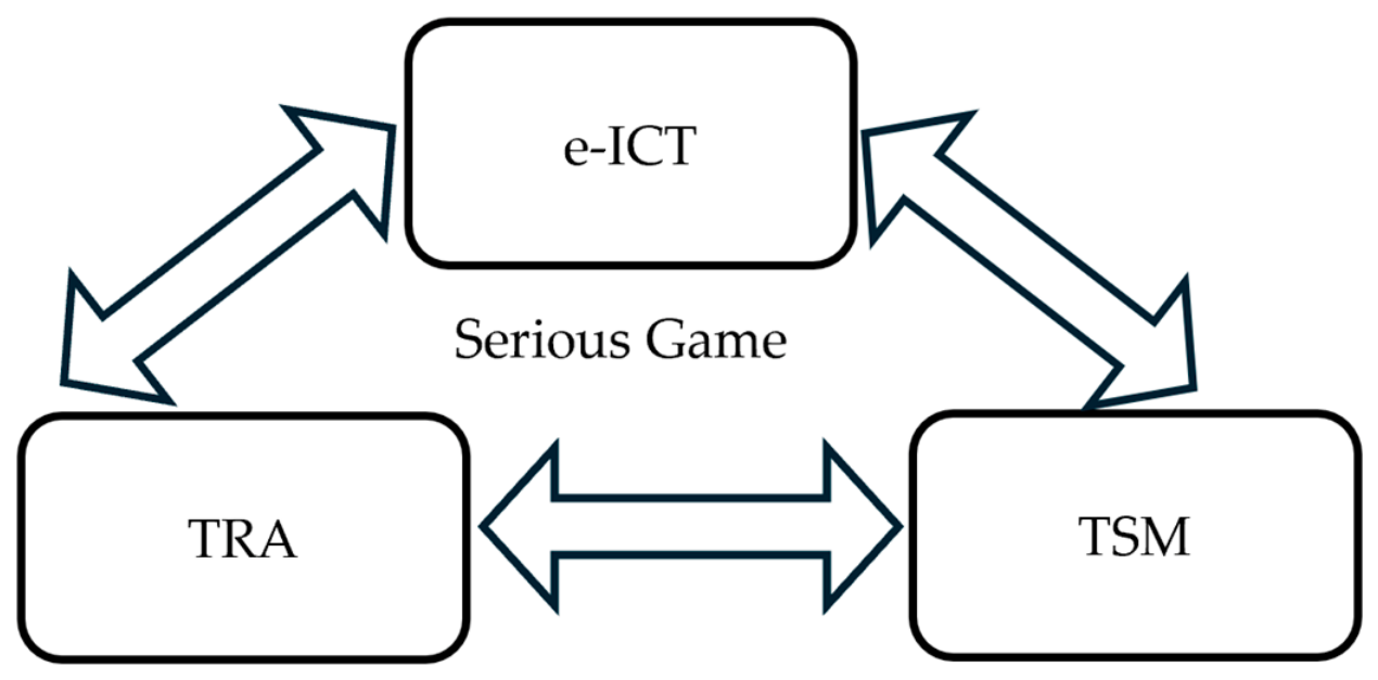
A Serious Game (SG) for simulating outdoor evacuation is the product of an integration between 3 components, as represented in Figure 2:
  • Transport Risk Analysis (TRA) for representing the occurrence and vulnerability of an emergency scenario S (tsunami, explosion, bomb, …) [11];
  • Transport System Models (TSMs) for simulating transport supply [12], transport demand [13] and their mutual interactions [14] for representing urban mobility in an evacuation condition;
  • emerging Information and Communication Technology (e-ICT) to reproduce, in a virtual environment, a transport system under evacuation conditions [15].

2.3. The Proposed SG Framework for Outdoor Evacuation

According to the objectives of this research, an SG represents an evacuation procedure set out in an emergency plan to be activated in response to a specific scenario S. To test the procedure for scenario S, it is possible to organize several game sessions (i) involving a group of players. The aim of the game could be to assess the participants’ knowledge of the road network to be used to reach the safe area specified in the plan.
The three main components are described as follows:
  • The TRA component is associated with a performance measure for exposure. The design of a simulation game (SG) for representing evacuation procedures can be aligned with a performance-based approach. This implies the need to be able to quantitatively measure the effect produced by a generic SG for a generic evacuation scenario S, organized into successive game sessions (i). The generic session (i), in which the generic participant (u) takes part, is denoted by aSSG,i,u. Session (i) simulates the evacuation procedures that the generic participant (u) will have to experience for scenario S. It is possible to introduce a set of indicators to assess the level of knowledge and skills acquired by the generic participant (u) during the generic game session. The indicators measure the improvement in the performance of individual participants in a GS, attributable to the risk exposure component. The indicator associated with the scenario, the session and the user may be represented as a quantitative measure.
  • The TSM components are mainly associated with variations in the network conditions. These variations imply modification of the network modeling and relative variables of the following transport supply analytical formulations. For a complete definition of the main formal equations of the transport supply system, reference is made to Cascetta [16];
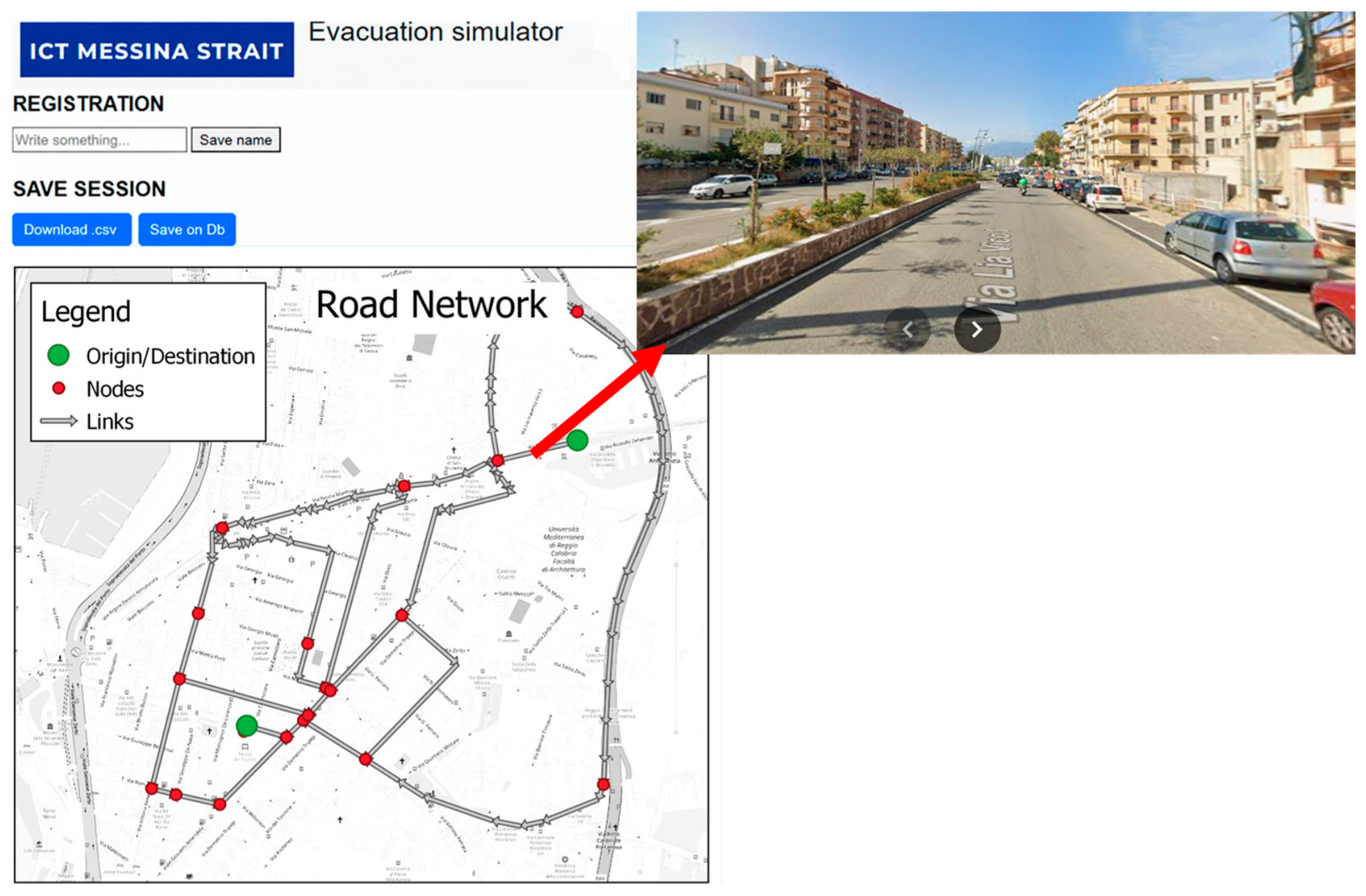
  • The e-ICT component is present in the form of the user interface of the SG. The transport supply model can be implemented using an interactive web map accessible to the general public. Open-source tools such as QGIS can be used to represent the nodes, links and cost functions of a road network. These can be customized according to the evacuation scenario to be simulated.
The quantitative characteristics of the transport supply system vary across different scenarios through changes to the vector c and the function γ. Each scenario (S) is organized into several game sessions (i). In each session, users are asked to choose a path from a shared starting point to a shared safe destination in the shortest possible time. Multiple sessions are necessary to understand whether choices change under the same conditions and to update information on previous choices. In this way, the study aims to investigate both the learning effect and preparedness in varying scenarios.

3. A Pilot Study

3.1. Study Area

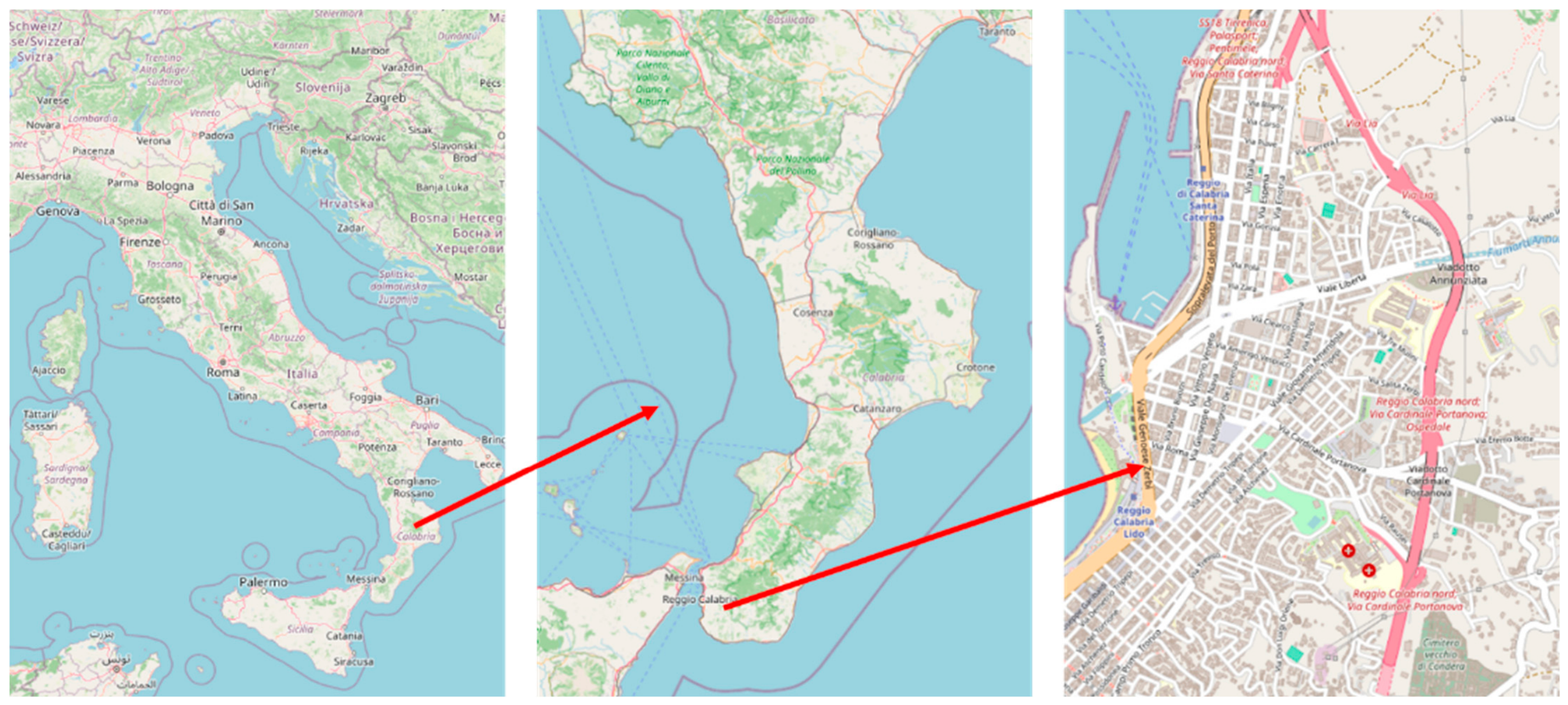
The study area is a portion of Reggio Calabria, a city of about 200,000 inhabitants in southern Italy [17]. Figure 3 represents the specific position of the study area.
The city is located in an area historically at high seismic and flood risk; it was recently hit hard by the passing of Cyclone Harry. The presence of a university campus and the area’s potential exposure to natural disasters make the area ideal for a case study. The game involves studying preparedness in relation to the connections between the university campus and the safe zone in the historic center, as defined in the emergency plan.

3.2. Exercise Design

During the SG, some road closure scenarios are simulated. In this study, two different scenarios are proposed:
  • S0 = Scenario 0 considers the entire road network. The network is a schematic representation of the study area, including the area north of the city’s historic center;
  • S1 = Scenario 1 considers closure on the main motorway link. Users are required to move within the entirely urban subnetwork.
Some quantitative indicators can be used to assess the user’s preparedness in terms of: orientation time, or the time needed for the user to find the solution, and evacuation time, or the time needed to reach the destination in the scenario condition by following the selected road path. In the performed experimentation, only orientation time has been measured.
For each scenario, people are informed of the network of roads available. No quantitative information is available other than the length of road links.
The game is designed primarily for people loosely familiar with the study area. Players can consult an interactive map with road images to help them make decisions, as represented in Figure 4.

3.3. Results

A pilot survey was conducted with a sample of 11 users, who were recruited from the student and teaching staff at the University of Reggio Calabria. The sample was predominantly composed of students aged 20 to 22 years (54%). Participants aged between 30 and 55 years accounted for 27% of the sample, while those over 56 years represented 19%. Ten sessions were organized within a single scenario, without modifications to the network structure. During each session, each user was asked to select a route from the starting point to the safe area from a set of available arcs on the map. At the end of each session, participants were ranked based on their evacuation times, which had been assigned to each route in advance by analysts. The primary objective of the pilot was to assess the orientation time of users, defined as the time required to complete the navigation task in each session, in order to select the evacuation route and relative time.
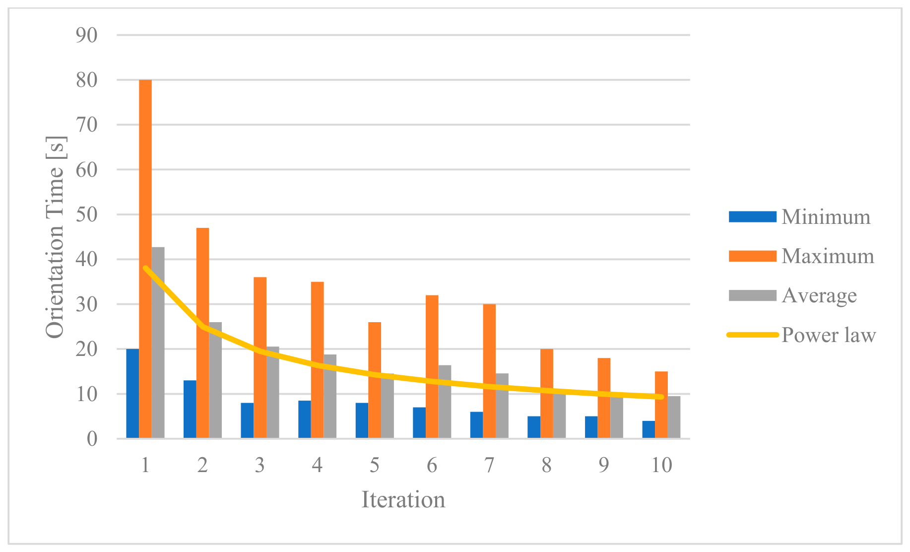
Execution time to conclude a session is a proxy of the orientation time variable. In the sample, the variable varies from a maximum of 80 s to a minimum of 6 s. It was modeled using a linear mixed-effects model with a power curve. The choice of the power curve is motivated by its ability to describe the typical learning pattern, characterized by rapid improvements in the first repetitions and progressively slower gains in the subsequent ones.
Data were log-transformed to linearize the relationship, estimating the model in the form log T = β 0 + β 1 l o g ( n ) , where T is the execution time and n is the repetition number. The model includes a fixed-effects component, estimating the average curve for the entire population, and a random-effects component, capturing individual differences in the starting level and learning rate among participants. The estimated fixed-effects parameters on the log scale are β 0   =   3.64 (SE = 0.147, t = 24.8, p < 0.001) and β 1 = 0.61 (SE = 0.052, t = −11.7, p < 0.001). Back-transforming to the original scale, the average power curve is T = 38.09 n 0.61 . The random-effects standard deviations were 0.46 for the intercept and 0.15 for the slope, with a negative correlation of −0.52 between them, indicating that participants with longer initial times tended to show faster learning rates.
Figure 5 reports, for each iteration, the minimum and maximum orientation time observed among participants, along with the average power curve estimated by the model.

4. Conclusions and Future Work

Emergency preparedness represents a priority for limiting the gap between the evacuation plan, developed in the mitigation phase, and its implementation in the response phase. Serious Game for evacuation that combines TRA, TSM and e-ICT is a suitable preparedness action. It is necessary to specify these tools to obtain performance measures about participants; the final aim is to measure quantifiable performance measures that may lead to improvement of their preparedness level and potential contribution to risk reduction.
This work proposes a framework for designing and implementing a Serious Game. The results of the prototype trial demonstrate the potential for measuring the effects of a training exercise to increase the preparedness of the users involved in the event of an evacuation via the road network. Conducting multiple game sessions shows a progressive reduction in learning time and therefore exposure. This assertion is corroborated by the outcomes of the pilot study. The results obtained, on a limited reference sample, demonstrate prototype feasibility and allow us to hypothesize subsequent studies to investigate the broad effectiveness for the general urban population.
This work presents different limitations. The main limitation concerns the introduced simplifications about TRA, TSM and e-ICT tools. The developed tool is a prototype that can be further developed to increase the level of immersiveness. This implies the necessity to produce more insights into methods, models and adopted technologies. Future research will be developed by designing a more complex SG that combines existing or new tools that allow for extending the experimentation to a more realistic simulated scenario, involving a larger sample size in order to obtain different performance measures related to a variety of emergency scenarios.

Author Contributions

Conceptualization, C.R.; methodology, C.R.; formal analysis, A.R.; investigation, A.R.; data curation, A.R.; writing—original draft preparation, C.R.; writing—review and editing, A.R.; visualization, A.R.; supervision, C.R. All authors have read and agreed to the published version of the manuscript.

Funding

This research received no external funding.

Institutional Review Board Statement

Ethical review and approval were waived for this study due to it being a non-interventional study that did not involve biological human experiments or patient data. The research activity proposed is a behavioral study that does not involve sensitive personal data, as defined by Article 9 of Regulation (EU) 2016/679 (GDPR).

Informed Consent Statement

Informed consent was obtained from all subjects involved in the study.

Data Availability Statement

The raw data supporting the conclusions of this article will be made available by the authors on request.

Acknowledgments

The authors would like to thank the students Vito Mustica and Sergio Scafaria for their generous support in developing the prototype.

Conflicts of Interest

The authors declare no conflicts of interest.

References

  1. Centre for Research on the Epidemiology of Disasters (CRED). 2025 Disasters in Numbers: Earth, Wind and Fire 2026. Available online: https://www.preventionweb.net/publication/documents-and-publications/2025-disasters-numbers-earth-wind-and-fire (accessed on 7 August 2026).
  2. UN SDG Indicators. Global Indicator Framework for the Sustainable Development Goals and Targets of the 2030 Agenda for Sustainable Development. Available online: https://unstats.un.org/sdgs/indicators/indicators-list/ (accessed on 7 May 2023).
  3. Russo, F.; Vitetta, A. Risk Evaluation in a Transportation System. Int. J. SDP 2006, 1, 170–191. [Google Scholar] [CrossRef] [Scilit]
  4. Alexander, D.E. Disaster and Emergency Planning for Preparedness, Response, and Recovery. In Oxford Research Encyclopedia of Natural Hazard Science; Oxford University Press: Oxford, UK, 2015. [Google Scholar]
  5. UNDRR. Sendai Framework for Disaster Risk Reduction 2015–2030. In Proceedings of the Third UN World Conference on Disaster Risk Reduction, Sendai, Japan, 14–18 March 2015. [Google Scholar]
  6. Russo, F.; Rindone, C. Methods for Risk Reduction: Training and Exercises to Pursue the Planned Evacuation. Sustainability 2024, 16, 1474. [Google Scholar] [CrossRef] [Scilit]
  7. Twigg, J. Disaster Risk Reduction: Mitigation and Preparedness in Development and Emergency Programming; Overseas Development Institute: London, UK, 2009. [Google Scholar]
  8. US FEMA Homeland Security Exercise and Evaluation Program (HSEEP) 2020. Available online: https://www.fema.gov/emergency-managers/national-preparedness/exercises/hseep (accessed on 7 August 2026).
  9. Russo, F.; Rindone, C. Planned and Implemented Actions by Exercises. In Computational Science and Its Applications—ICCSA 2024 Workshops; Lecture Notes in Computer Science; Gervasi, O., Murgante, B., Garau, C., Taniar, D.C., Rocha, A.M.A., Faginas Lago, M.N., Eds.; Springer Nature: Cham, Switzerland, 2024; Volume 14821, pp. 28–40. [Google Scholar]
  10. Laamarti, F.; Eid, M.; El Saddik, A. An Overview of Serious Games. Int. J. Comput. Games Technol. 2014, 2014, 358152. [Google Scholar] [CrossRef] [Scilit]
  11. American Institute of Chemical Engineers (Ed.) Guidelines for Chemical Transportation Safety, Security, and Risk Management, 2nd ed.; John Wiley: Chichester, UK, 2008. [Google Scholar]
  12. Musolino, G. Methods for Risk Reduction: Modelling Users’ Updating Utilities in Urban Transport Networks. Sustainability 2024, 16, 2468. [Google Scholar] [CrossRef] [Scilit]
  13. Russo, F.; Comi, A.; Chilà, G. Dynamic Approach to Update Utility and Choice by Emerging Technologies to Reduce Risk in Urban Road Transportation Systems. Future Transp. 2024, 4, 1078–1099. [Google Scholar] [CrossRef] [Scilit]
  14. Vitetta, A. Influence of Vehicular Flow Instability in a Transport Network on Risk Reduction: Test in a Two-Link Network. J. Adv. Transp. 2025, 2025, 7966144. [Google Scholar] [CrossRef] [Scilit]
  15. Rindone, C.; Russo, A. Disaster Risk Reduction in a Manhattan-Type Road Network: A Framework for Serious Game Activities for Evacuation. Sustainability 2025, 17, 6326. [Google Scholar] [CrossRef] [Scilit]
  16. Cascetta, E. Transportation Systems Engineering Theory and Methods; Springer: Berlin/Heidelberg, Germany, 2013. [Google Scholar]
  17. Istituto Nazionale di Statistica (ISTAT) Demografia in Cifre 2026. Available online: https://demo.istat.it/ (accessed on 7 August 2026).
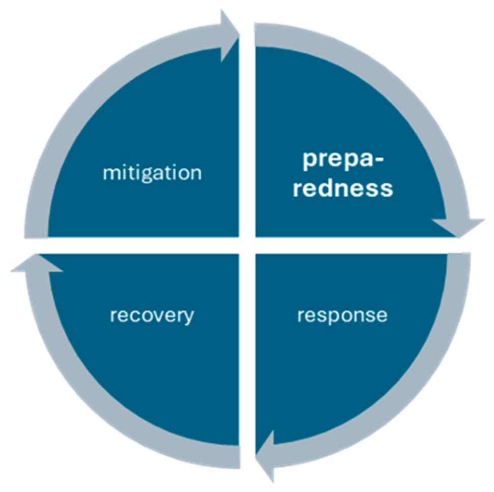
Figure 1. The four phases of the disaster risk management cycle.
Eesp 45 00007 g001
Figure 2. The three main components of a Serious Game (SG) for outdoor evacuation.
Eesp 45 00007 g002
Figure 3. Analyzed city.
Eesp 45 00007 g003
Figure 4. Game interface and selected road link (Scenario 0).
Eesp 45 00007 g004
Figure 5. Graphical representation of the results obtained.
Eesp 45 00007 g005
Disclaimer/Publisher’s Note: The statements, opinions and data contained in all publications are solely those of the individual author(s) and contributor(s) and not of MDPI and/or the editor(s). MDPI and/or the editor(s) disclaim responsibility for any injury to people or property resulting from any ideas, methods, instructions or products referred to in the content.