Article

Crafting Glacial Narratives: Virtual Exploration of Alpine Glacial and Periglacial Features in Preston Park, Glacier National Park, Montana, USA

1
College of General Studies, University of Phoenix, Phoenix, AZ 85040, USA
2
Department of Earth and Environmental Sciences, Mount Royal University, Calgary, AB T3E 6K6, Canada
3
Department of Geography, University of Hildesheim, 31141 Hildesheim, Germany
4
Department of Cultural Sciences, Mesa Community College, Mesa, AZ 85202, USA
5
AI/ML Solutions, Tecnotree, 02150 Espoo, Finland
6
Sustainability Education Ph.D. Programs, Prescott College, Prescott, AZ 86301, USA
7
Department of Geography, Texas State University, San Marcos, TX 78666, USA
8
Mary Lou Fulton Teacher’s College, Arizona State University, Tempe, AZ 85212, USA
*
Author to whom correspondence should be addressed.
Glacies 2024, 1(1), 57-79; https://doi.org/10.3390/glacies1010005
Submission received: 31 July 2024 / Revised: 24 August 2024 / Accepted: 27 August 2024 / Published: 6 September 2024

Abstract

Virtual learning environments (VLEs) in physical geography education offer significant potential to aid students in acquiring the essential skills for the environmental interpretation of glacial and periglacial environments for geoscience careers. Simulated real-world field experiences aim to help the student evaluate landscapes for natural hazards, assess their intensity, and translate and communicate this information to various stakeholders in human systems. The TREE-PG framework and VRUI model provide a philosophical and practical foundation for VLE architects, aiming to cultivate students’ knowledge, skills, and identity as geoscientists, specifically as physical geographers and geomorphologists. These frameworks emphasize the importance of translating scientific knowledge from physical features into engaging, accessible online lessons, exemplified by landscapes like those in Glacier National Park, Montana. Open-source software and open educational resources (OERs) can broaden access and incorporate diverse perspectives in these experiences, which are necessary to address the impacts of vulnerable communities to global deglaciation. Designing and creating virtual proxies of field-based education may help address issues associated with inclusion and belonging within geoscience disciplines to connect all students with dynamic physical environments beyond the classroom. Ethical AI approaches and discipline-specific repositories are needed to ensure high-quality, contextually accurate VLEs. AI’s tendency to produce output necessitates using domain-specific guardrails to maintain relevance and precision in virtual educational content.

1. Introduction

As the environment responds to rapid change (global warming and impacts from human activities), the workforce needs geoscientists to interpret the environment and its response to these changes. The Bureau of Labor Statistics [1] projects a 5% increase in the geosciences field sector between the years 2023 and 2032. Specifically, geoscientists are needed to collect and analyze data to interpret changes in the earth and environment, which can yield important trends for developing policies, environmental planning, and environmental management and decision making.

1.1. The Geoscience Labor Shortage Problem

Despite the need for more geoscientists, the American Geosciences Institute identified a decline in the number of students entering the field, down from 312,000 in 2016 with a projected shortage of 118,000 workers, and at the time of the reporting, only 35% of the geoscientists were women [2,3]. Additionally, most of these scientists hold a bachelor’s degree, which emphasizes the importance of bachelor’s level programs in the development of this workforce [1,4]. In 2021, it was calculated that in the following decade, the labor market demand for geoscientists who hold bachelor’s degrees may grow by as much as 10% [4]. Even with innovation that might help fill the labor market needs, it will be insufficient to address the needs required for field and place-based sciences; thus, bachelor program leaders in environmental sciences and geosciences must develop the student with both the curricular knowledge and the skills employers seek [5,6].

1.2. Bridging Educational Gaps in Physical Geography to Develop Field Assessment Skills in Interpreting Glacial Environments

Institutions of higher education with physical geography as part of their curriculum are adept at building capacity for a geoscience workforce, as the skills for interpreting physical environmental patterns and processes are indispensable in understanding earth systems [7]. This indispensable nature for developing future geoscientists is particularly true during a period of global deglaciation in which comprehending the rapid change in polar and alpine glacier environments in response to a changing climate can help environmental managers plan to support human and natural communities [8]. Student expertise developed in these classes not only aids in their understanding to mitigate the impacts of climate change but also plays a crucial role in understanding the hydrological cycle to manage water resources, predict and prepare for natural hazards, and elicit lessons from the past to secure a more resilient future [8]. To support students in developing the knowledge and skills for interpreting the earth’s patterns and associated processes, educators in geography and geoscience must first assist students in the development of foundational knowledge and mental model construction [7,9]. Students also need access to exemplars of these environments, both past and present, to build the skills of site assessment as targeted to polar and alpine glacier landscapes. With issues associated with equitable access and safety associated with field-based education, virtual learning experiences (VLEs) have become important to fulfill this need in higher education [10]. The use of virtual simulations to study geographical features and processes when fieldwork is not possible is important for students to develop the interdisciplinary cognitive lenses necessary in fieldwork to study and interpret the landscape. A current gap in the field is the integration of iconic glacier environments as VLEs, which could significantly enhance the development of subject matter expertise in glacial environments and help cultivate the pipeline of geoscientist talent essential for the geoscience career sector.
However, therein lies a second problem: there is a notable gap in the use of VLEs in field-based physical geography education [11,12]. This theory-to-practice gap hampers the full potential of VLEs [13]. The field of education research is expansive, and as new technologies emerge, considerations for integrating tools with existing theories may be overwhelming for curriculum developers in geomorphology and physical geography. Moreover, with the human and environmental connection of this topic, VLE architects whose background is specific to geography are needed to fully contextualize these types of VLEs. The use of VLEs in education is further complicated if the learning experience developer does not have expertise in education theory, as an understanding of those philosophies may impact the ability to construct effective VLEs [13].

1.3. Objective of This Work

This paper addresses the theory-to-practice gap and is developed to support field-education VLE designers and architects who may lack background in geography and education theory. It has two parts. In part one, we adopt and adapt a conceptual model, Translating Research in Environmental Education for Physical Geography (TREE-PG), to provide readers with a knowledge of relevant theories for innovative STEM education and practice. Part one continues by introducing the Virtual Reality User Interface (VRUI) model as a curriculum planning tool to bridge the theoretical constructs in TREE-PG and applied VLE design. TREE-PG and VRUI are adaptable across multiple levels of teaching and instruction.
In part two, we demonstrate an illustrative example of TREE-PG and VRUI in action. Combined, each supports the design and development of a VLE targeted to building foundational knowledge and skills to support field-based site assessment for an Introduction to Physical Geography course. The topic of the illustrative example focuses on alpine glacial landscapes in Glacier National Park, Montana, USA. Finally, we provide a potential method, informed by TREE-PG, for assessing VLE education choices in curriculum development.

2. Part I: Addressing the Theory to Practice Problem in VLE Development

Education content designers draw from multiple, diverse theories to create effective learning experiences. Learning theories describe assumptions, limitations, and explanations of knowledge and learning. With appropriate theoretical understandings, content designers can begin to consider what effective learning environments may be, as implied by each theory of learning. A solid conceptual framework, rooted in seminal education theory, guides design and instruction to consistently and intentionally develop students’ working models of knowledge [14]. Greener [15] noted that standardized virtual, online environments are less innovative than diverse and flexible online experiences with more project-based learning interventions and limit students’ imagination. Conversely, an educator’s approach to the design of an online environment can expand learning potential and promote knowledge building. Learning in a virtual environment can be optimized by understanding, adopting, and applying learning theories to ordered stages of VLE development. A higher-level VLE guided by educational theories prioritizes consistency with clear objectives, active engagement, and structured content delivery. It draws from pedagogical theories like social constructivism, experiential learning, and situated learning to foster intentional design choices, which increase the likelihood of meaningful learning outcomes. In contrast, a lower-level virtual field trip often lacks consistency in philosophical design choices, resulting in weakly defined or aligned objectives and interactivity with informal, passive exposure to content disassociated from educational theory and structured learning.

2.1. Towards a Theoretical Framework for VLEs: TREE-PG

To maintain quality in the VLE, it is necessary to relate content to education theory that best describes and thus supports learning. We adopted a conceptual model originally used to support the translation of education theory into undergraduate online general education math courses [14]. By implementing that conceptual model, Translating Research in Environmental Education (TREE) [16], the authors observed increases in student persistence, performance, and sentiment for a large sample of nontraditional, online learners with characteristics of marginalized populations [14]. From TREE, we identify the following theories as being important for knowledge building and skills related to place-based, field experiences: social constructivism, conceptual change, academic self-concept, systemic functional linguistics, situated cognition, and experiential learning. In addition to these theories, our team added three additional pedagogical constructs: sense of place, spatial thinking, and Ludic Pedagogy (Table 1). Individual nuances of theories and constructs may not be captured to their full extent in the descriptions within this paper. However, even a simplified understanding can influence design choices that can positively impact VLE development. A limitation of TREE-PG is that it is a combination of multiple theories and constructs. Some of those may, at times, be in conflict with one another, as any different theories might be. In part two of this paper, an illustrative example will be provided to show how potential conflicts between theories were addressed in practice.
The additional constructs added to TREE to create TREE-PG, a framework aligned in the context of physical geography, are sense of place, spatial thinking, and Ludic Pedagogy. First, we discuss sense of place. Educators use sense of place to help students personally connect to more challenging, complex geography education topics [46,47]. An individual’s understanding of place is foundational to the perception of the world around us, and from our comprehension, we derive and ascribe meaning to physical features and the earth’s systems [41]. Place-based education defines place as “any locality imbued with meaning” and can hold multiple disciplines’ content and context within that location [41,48]. Through the concept of place and engagement with the community, it is possible to create a transdisciplinary approach and develop science concepts and skills in formative encounters that excite learners’ interest in pursuing physical geography. Second, we discuss spatial thinking. Spatial thinking is the knowledge and recall of spatial concepts and the mental process of reasoning how phenomena are located, their associated scale and size, their relationship with other phenomena, patterns, and changes in those phenomena over time [42,43]. Tools to represent phenomena assist this reasoning process [43]. Third, we discuss Ludic Pedagogy, a relatively new pedagogical model developed as a response to the COVID-19 pandemic to engage online learners through fun, positivity, and play, with fun and playfulness being a critical element in learner’s motivation [45]. This capability with new technologies allows for the opportunity of intentional gamification. With this additional layer of movement and play, Ludic Pedagogy provides complexity for the whole-body experience that may impact the learner’s cognitive processes associated with affect, learning outcomes, and performance.
VLEs constructed with TREE-PG as a conceptual framework combine ideas from social constructivism, conceptual change, academic self-concept, systemic functional linguistics, situated cognition, experiential learning, sense of place, spatial thinking, and Ludic Pedagogy and, as such, can help understand and predict how to overcome learning barriers and promote a learning environment consistent with student success. TREE-PG helps define assumptions and biases about learning, teaching, and assessing. The application of this framework requires the introduction of the Virtual Reality User Interface (VRUI) orders. The VRUI order model introduced below is used as a planning tool to apply the complex theoretical constructs from TREE-PG to the construction and architecture of the actual VLE.

2.2. Towards Applied Design for VLEs: VRUI Planning Tool

We describe the components of VLE development in physical geography in the VRUI planning tool, which outlines the architectural pieces of VLEs that must be created. The model representation of VLE components is shown in Figure 1, which depicts concentric orders to inform VLE design considerations for VLE architects. Each order describes an additional layer within the VLE, including relevant design components and considerations for VLE development.
The VRUI orders identified for the VLE are as follows: core learning objectives (CLOs) (Center) drive the development as they are the intended learning outcomes from the VLE. The First-Order VRUI is the photo sphere, the visual setting to build the student experience. The Second-Order VRUI is the instructional intervention. The Third-Order VRUI is the contextual application to support knowledge transfer outside of the VR interface. The spaces between the concentric rings are left unfilled to represent the unknown, invisible processes that occur during this knowledge acquisition and transference.
The VRUI model deconstructs the set of components that a user engages with so that the VLE designer can consider individual parts to construct. Listing the VRUI orders and how TREE-PG is used to support the development of each order can guide design to maximize the learning experience. While all theoretical constructs within TREE-PG may be applied to every VRUI order, there are some that are more strongly aligned or have the potential for greatest impact when considered within the context of specific VRUI orders. Table 2 outlines our recommendations for which TREE-PG constructs to consider during the development of each VRUI order. Guiding questions may support the efficacy of the development process by focusing the VLE architect on specific considerations that will impact the learning environment. Answers to these high-level philosophical questions will change the design choices that are made. Theories and philosophies provide insights into how to answer these questions.
Table 2 illustrates how VRUI orders can be informed by TREE-PG constructs. If each VRUI order is not intentionally guided by TREE-PG, the resulting VLE may lack the philosophical continuity required to adequately scaffold learning for the learner and an absence of knowledge and skills may create conflict for the learner. The following is a brief discussion to support the implementation of TREE-PG constructs for the development of each of the VRUI orders. As mentioned before, this paper will be unable to discuss the nuances of each of these constructs in full. The authors strongly recommend readers interested in the use of TREE-PG and VRUI continue studies for each of the constructs. However, the following high-level overview may be supportive when first engaging in VLE development.
The Core order of the VRUI encompasses the intended learning objectives of a VLE. Though these are often driven by curricular decisions, it is still important to examine theoretical assumptions associated with these objectives. The most relevant TREE-PG constructs associated with this order are social constructivism, conceptual change, systemic functional linguistics, and spatial thinking. Table 3 outlines specific components of the Core VRUI and how each TREE-PG construct might guide their development.
The first order, the photo sphere, includes all visual components of the VLE. The most relevant TREE-PG constructs associated with this order are social constructivism, academic self-concept, sense of place, spatial thinking, and Ludic Pedagogy. Table 4 outlines specific components of the First-Order VRUI and how each TREE-PG construct might guide their development.
The second order, the instructional intervention, includes strategies for learning. In this order, learning takes place and is assessed. The most relevant TREE-PG constructs associated with the second order are social constructivism, conceptual change, academic self-concept, systemic functional linguistics, situated cognition, experiential, spatial thinking, and Ludic Pedagogy. Table 5 outlines specific components of the Second-Order VRUI and how each TREE-PG construct might guide their development.
The third order, contextual application, extends student learning through authentic application. The most relevant TREE-PG constructs associated with this order are academic self-concept, systemic functional linguistics, experiential learning, spatial thinking, and Ludic Pedagogy. Table 6 outlines specific components of the Third-Order VRUI and how each TREE-PG construct might guide their development.
Integrating theories and constructs from education research, like those in TREE-PG, with a planning tool like VRUI may maximize the application of theory to practice in VLE design. Additional details will be discussed in the illustrative example of the VLE created to explore alpine glacial landscapes in Glacier National Park. When paired with a development process, TREE-PG and VRUI can impact learning environments that may best support students.

2.3. Adapting VRUI Orders to a Stepwise Development Process

A development process is required to support VLE architects with incorporating relevant ideas from education theory into the VLE. The authors propose adapting Table 2 information and using the guiding questions and theoretical suggestions in Table 3, Table 4, Table 5 and Table 6 to translate and develop an intentional approach for lesson development for the collection of information needed to create the VLE components at each of the different orders: Core Learning Objectives, First-Order VRUI, Second-Order VRUI, and Third-Order VRUI. At the most basic level, these planning tools allow us to take TREE-PG, the conceptual framework, and apply it through VRUI orders for VLE creation.
The learning theories as applied in Table 3, Table 4, Table 5 and Table 6 serve as frameworks for interpreting and rationalizing design choices in educational settings. While these theories do not directly determine specific learning outcomes, they guide educators in designing experiences that enhance the learning process by providing a lens through which to understand the principles of learning and knowledge. Rather than assuming that a particular theory will cause students to learn in a specific way, VLE architects can more consistently define and align learning outcomes by integrating the explanations and recommendations of these theories with the components of virtual learning experiences, ensuring that each strategy is thoughtfully implemented based on its underlying assumptions. The illustrative example to follow describes the implementation for the creation of a glacial and periglacial landscape field site assessment VLE.

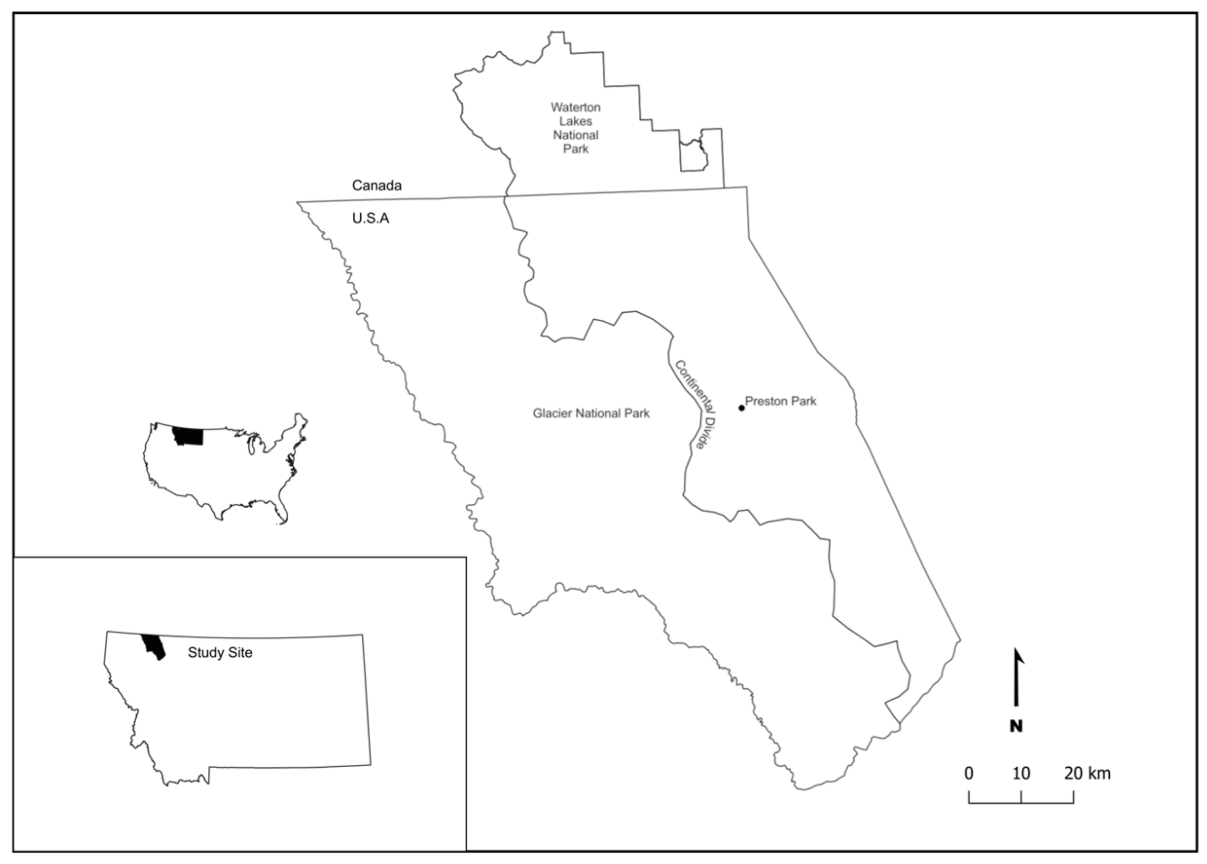
3. Part II: Implementing TREE-PG in VLE Development to Build Geoscience Field Assessment Skills Using Preston Park, Glacier National Park, Exemplar

To develop the illustrative example of TREE-PG and VRUI in action using glacial and periglacial environments, we used the example of the Western Cordillera of North America with a focus on Glacier National Park (GNP). GNP is joined by Canadian Waterton Lakes National Park, which together function as the world’s first international Peace Park meeting the UNESCO World Heritage criterion (criterion vii): “Both national parks were originally designated by their respective nations because of their superlative mountain scenery, their high topographic relief, glacial landforms and abundant diversity of wildlife and wildflowers” [49]. Peace Parks are designated because these areas contain a rich assortment of biodiversity and geodiversity features as well as breathtakingly beautiful and unmatched scenic views that function as a biosphere and geosphere reserve. These places serve as iconic exemplars of outstanding value housed within unique climate and physiographic settings [49].
The geographic setting of this location features the Continental Divide as the boundary between western and eastern Glacier National Park, with Preston Park found just on the southeast side of the divide along the Siyeh Trail in the Lewis Range (with an elevation of 2205 m, and the latitude is 48.7014 and the longitude is −113.6695) (Figure 2). The Lewis Range features dramatic topography characteristic of the alpine environments and the associated flora and fauna. The expanse of the scene is captivating, with elegant perspectives of ribbon forests and wildflower meadows that have low-growing vegetative growth forms to allow sufficient views to showcase the glacial geomorphology features that characterize this site and dominate the landscape.
The scene of Preston Park was chosen because of its expansive viewshed, which contains several viewing zones with notable iconic glacial features that could be placed with ergonometric comfort in mind [50]. The expansive and scenic views invite awe and wonder, which stimulates the VLE user to explore curiosity zones. These zones have the potential to instill awe and wonder, initiate affective emotion, and engage the cognitive learning process [51,52,53].

3.1. VRUI Order: Core Learning Objectives (CLOs)

For the VRUI order associated with the CLOs, we wanted to focus on the educational value of the landscape that houses examples of glacier-created features and processes associated with their formation that are perceptible by the novice learner in an introductory physical geography course. The development of VLE core learning objectives focused on alpine glacial and periglacial geomorphology patterns and processes to support the student knowledge development of earth systems (biosphere, hydrosphere, lithosphere, and atmosphere) and how these interact. We used a learning construct to identify and develop the core learning objectives for VLE development.
Using Table 3, the development of the core learning objectives requires us to define our goals for the VLE. Our goals are for the student to (1) understand how natural systems operate, (2) develop analytical skills to interpret natural patterns and processes, and (3) prepare students to address environmental challenges. We use social constructivism to understand the potential social interaction mechanisms that may meet the requirement of eliciting students’ existing knowledge of physical geography and earth systems so that we may establish the baseline of knowledge and root out any misconceptions. We use the conceptual change theory to understand that the prior knowledge elicited must be used to identify, confront, and resolve student misconceptions because replacing nonnormative information with technically accurate information and concepts grounded in science is a requirement for learning. If these preconceptions are not overcome, and if the appropriate concepts and language are not used to address them, student learning is obstructed as their mental models of the features, patterns, and processes are either incorrectly constructed or cease to be constructed at all. We use systemic functional linguistics (SFL) to understand that language is context-dependent and must be critically considered to ensure that the language in the learning objectives is clear, precise, and appropriate for the intended audience with the intended meaning. Terminology and phrasing used must be accessible yet scientifically accurate while being clear about the assumptions associated with tone, audience, context, and meaning.
Spatial thinking, as applied to core learning objective development with glacial features, patterns, and processes, assists students in providing guidance for the interactions between the visualization and comprehension of relationships between different glacial landforms and their geographical distribution. This approach connects the feature pattern to the dynamic nature of glacial processes (erosion, deposition, and ice movement) and guides the student to mentally map and predict changes over space and time. Furthermore, spatial thinking provides clues for how to engage the student in key problem-solving skills to analyze spatial data, recognize patterns, and make informed inferences about glacial phenomena and their broader environmental impacts.
To refine our CLOs, our team used Strabo artificial intelligence (AI). Strabo AI is actively in development, using open-source models and software to be a constrained AI assistant that houses a knowledge base of geography-specific lessons and supporting content. These resources are all marked with the Creative Commons License for the ethical remix and adaptation of geography education content. Prompts are created in “workspaces” that support text and graphics. In the workspace for CLOs, we used a template for a prompt generation that asked Strabo AI to be a lesson planner in a college-level “Introduction to Physical Geography” course, we input each CLO one at a time (for targeted and deep reflection by the VLE architect), and included the following query: “How can I refine these learning objectives to build student knowledge and skills for glacial environments?” Once this information is fed into the Learning Language Model (LLM), then a response is generated (Figure 3). VLE architects and lesson developers can study lesson plans from which Strabo AI draws the language and information to refine the CLOs. These lesson plans were developed by seasoned teachers who have participated in professional development programs supported by the Arizona Geographic Alliance, GeoCivics Academies, and the National Council for Geographic Education [54] (Figure 4).
These lessons loaded into Strabo AI are exemplars in their research, structure, and design as a model for development. They feature the grade level so that developers can analyze the content to adjust for targeting appropriate academic rigor. As more VLE architecture is completed for the Creative Commons for Strabo to consume, such as the VLE that is the basis for this paper, then more examples at the various grade levels will be available to influence the constrained AI output. The content still needs to be analyzed for contextual recall, precision, and relevancy [55], and this work is the precursor for further analysis.
We analyzed the response to confirm output accuracy and applicability for the VLE; we reflected on the response and prompted the AI with more guiding questions to limit the number of Bloom’s taxon used for further iteration to maximize the effectiveness of the CLOs. As Strabo AI uses the previously designed and vetted, peer-reviewed lesson plans to search for learning objectives and their construction, hallucination (erroneous or nonsensical output) is limited. However, we have not yet tested the difference in accuracy between multiple AI agents. The CLOs developed before the prompt were as follows:
  • Identify environmental patterns of physical features;
  • Develop the connection of earth processes that create these patterns;
  • Evaluate the terrain for a visual site assessment of features associated with hazards.
  • The Strabo AI refined prompts yielded the following CLOs:
  • Identify the environmental patterns of glacial features in an alpine region;
  • Analyze the physical geographic processes that create the unique physical features of glacial environments in the alpine region;
  • Evaluate the terrain for visual site assessment of features associated with glacier hazards in the alpine region.
Once the CLOs are established, VRUI First Order, the photo sphere, can be developed for use for VLE development. The visual component will establish the virtual proxy for the real-world alpine glacier environment.

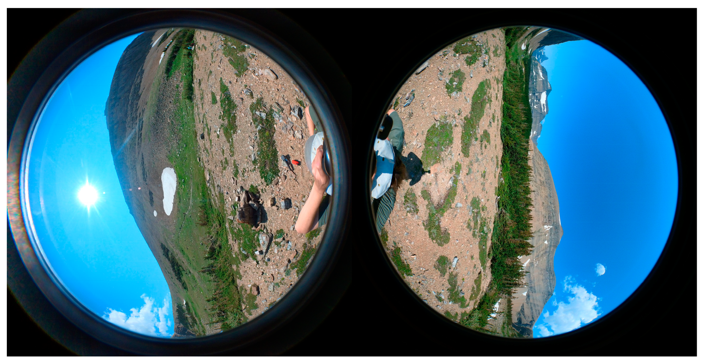
3.2. VRUI First Order: Photo Sphere

The field collection of resources to develop the photo sphere included a collection of digital 360-degree photography and field notes of the Preston Park site. Data collection took place in July 2021 on a day when the skies were clear for a clear visual representation of the site. Several locations along the Siyeh Trail were identified as having physical features and scenic landscapes that were considered engaging to students in a physical geography classroom. Each of these site viewsheds was assessed for the maximum number of physical features that might be visually perceptible in sufficient detail to describe the physical pattern and the earth process associated with that pattern. Obstructions to the view were considered before the digital image capture.
Photo sphere capture was taken at the site to visualize a 3-D simulation of the alpine glacier 360° landscape. An Insta360 ONE R digital camera was used to capture both the Preston Park site front and back views (Figure 5). Post-processing calibration was used to minimize distortion. The photo sphere collection was taken at the highest elevation length of the trail prior to the switchback that leads to the highest elevation point of Siyeh Pass.
The importance of field notes lies in communicating on-site features with detailed, immediate observations that might be overlooked or forgotten later. Maintaining a record of accurate and comprehensive documentation of the field environment ensures the inclusion of qualitative data necessary to contextualize the spatial story’s sense of place and the field recorder’s subjective impressions. The photograph alone provides insufficient structure to organize the information. For example, field notes at the Preston Park site provide detailed observations of various environmental conditions and geological and geomorphological (Table 7), and biological phenomena. Field researchers recorded site-specific details to log geographic coordinates, topographic features, plant communities, wildlife sightings, weather conditions, and human interactions. Researchers noted specific abiotic features such as the sedimentary rock of the Siyeh Formation, talus slopes, and scree, showing evidence of freeze–thaw processes and depositional patterns and movement; Mt. Reynolds’ horn, situated within the u-shaped valley, cirque glaciers, Siyeh Pass, and periglacial ground with turf bank terraces were also observed. Notes further reflect subalpine forest composition and tree island formation, with branches exhibiting directional wind flagging and associated winter injury. Sightings and signs of local wildlife are included with elk (Cervus canadensis) and grizzly bears (Ursus arctos) in the area. Thus, field notes facilitate clearer communication and analysis when sharing findings with others or integrating them into virtual field experiences. The field notes collected in July 2021 underwent analysis and discussion by three of our team members, one of whom has exceptional expertise in the geomorphology of GNP, in September 2021. The resulting analysis yielded the identified glacial and periglacial physical features of interest in the Preston Park photo sphere (Table 7).
For the VRUI First Order, to adapt these learning theories for the virtual proxy of the landscape, it is essential to integrate the constructs into the resources and information that amend the photo sphere. Social constructivism supports an understanding of how to apply visual cues to prompt social interactions and their potential impact in creating a collaborative learning environment. Information points embedded with fun facts or figures can serve as interaction points such as discussion starters for students to observe, discuss, and reflect. Academic self-concept helps describe the importance of user self-perception for the learning process, helping to inform how the photo sphere should be designed to be welcoming and accessible, promoting students’ sense of belonging and inclusivity. By incorporating a fixed reference point for a digital twin of a person or phenomena, students can embed themselves within the photo sphere and see themselves within the content of the visual environment.
Applying approaches to the VRUI First Order, we use a technique that enhances student perception to develop place attachment. Sense of place is an approach that describes conditions that evoke feelings of connection to the virtual environment by engaging the senses and positive emotions, making the learning experience more immersive and meaningful. There is a design consideration for sense of place in that the user’s comfort must be considered as not to impair affect and emotion and to maintain ergonometric comfort so that the VLE user can focus on the virtual site for greater impact, with Purwar’s [50] recommendations for virtual experience design with ergonometric and information point placement carefully considered (Figure 6). The strategic placement of information points in the virtual reality considers the user’s natural field of view to minimize physical discomfort while enhancing the general ease of engaging with embedded information in the virtual environment. The Preston Park VLE was designed to reduce neck strain through the intentional positioning of information points within a comfortable range of the user’s central viewshed. Spatial thinking is another approach that outlines mechanisms that may support a more geographic cognitive lens through which the size, scale, direction, and orientation of glacial features are observed to interpret the visual patterns of a glacial landscape and align these observations to natural mechanisms for a holistic view of the environment under site-specific conditions. Finally, integrating ideas from Ludic Pedagogy discusses potential gains from making the photo sphere visually appealing and fun. Alterations to the photo sphere could make engagement comfortable, leave room for curiosity and exploration, and incorporate elements of gamification to enhance learning.

3.3. VRUI Second Order: Instructional Intervention

The VRUI Second Order involves developing the instructional intervention. The following learning theories and associated approaches are necessary for understanding learning and instruction to achieve the CLOs guiding lesson development on glacial and periglacial environments and site assessment: social constructivism, conceptual change, academic self-concept, systemic functional linguistics, situated cognition, experiential learning, spatial thinking, and Ludic Pedagogy. These learning theories and approaches provide insights which can lead to a comprehensive framework for designing effective instructional strategies, ensuring that learning objectives are met.
Social constructivism accentuates the use of social interactions in learning because these interactions lead to co-constructed knowledge that elevates and expands the context of the ideas, potentially bringing to light associated misconceptions and preconceptions. When students discuss glacial and periglacial environments with peers and instructors, this discussion can deepen their comprehension of complex ideas around glacial landforms and processes and help students retain this information. The learning theory of conceptual change describes the impact of preconceptions on learning and provides guidance about how to elicit, confront, and resolve misconceptions, including the likelihood that anomalous information is integrated into knowledge construction. Instructional opportunities of the student revision of prior thinking offers space to confront and resolve misconceptions about glacial features and how processes work. Students can be provided opportunities to explore scaffolded information and refine their understanding into more accurate mental models that bridge the visual environment to knowledge and remove potential barriers to learning. Academic self-concept, which underscores the student’s need to feel valued within the learning community and the discipline, provides a framework for understanding the types of inputs that impact student academic self-concept. For the field science career contingent, the heart is as important as the mind in creating the next generation of the workforce. When student belief is influenced by the perception of belonging to both a discipline and community, they may feel their contribution matters, unlocking their motivation and engagement, which may lead to better learning outcomes in site assessment and environmental impact analysis. Systemic functional linguistics provides models for supporting the VLE lesson developer to incorporate the technical terminology related to glacial and periglacial environments and ensure that the translation from more technical language to appropriate grade-level interpretation is clear to address knowledge gaps and clarify concepts for the student. Situated cognition extends principles from systemic functional linguistics into the diverse cognitive strategies beyond language, informing information and activities within the lesson within the context-dependent glacial environment. Learning about glacial environments should occur in both the lesson writing and the incorporated visual proxy, and all digital geomedia and imagery about glacial environments should support this context. With proper support, students may transfer and apply their knowledge more successfully to real-world scenarios and site assessments. Experiential learning stresses the impact of meaningful experiences, learning environment norms, and reflection on learning. Engaging students in hands-on site assessment activities that relate back to the virtual glacial environment encourages a reflection on these features, processes, and associated natural hazards. This also encourages a reflection on human communities confronting challenges and may help them integrate and solidify their knowledge about glacial processes and features.
Applying approaches to the VRUI Second Order, spatial thinking outlines mechanisms to develop and deepen the student understanding of the spatial dimensions of the landscape and its features. Isolating features as components of the landscape and applying scale, distance, and time within the Earth’s system may elucidate the influencing processes (Figure 7a–h). Instruction should provide many different types of visual representations to help students detect spatial patterns and infer the drivers of glacial phenomena. Finally, Ludic Pedagogy supports gamification to make learning enjoyable and can involve the participation of subject matter experts, teachers, and students. By incorporating elements of fun and playfulness, students are more likely to be motivated and engaged, enhancing their learning experience and performance in studying glacial and periglacial environments. For this VLE, light role play as a field researcher tasked with conducting a site assessment to collect data, organize them, and score a risk level is one way students can play and practice geoscience career skills.
We assessed the Preston Park site for glacier geomorphic variability to locate glacial feature examples (Figure 7a–h). Field notes of notable features and field team observations were used for VLE development (Table 7). Glaciers and cryo-processes make landscape adjustments associated with erosion and deposition and indicate directional movement. Glacial geomorphic evidence provides a means to compare different periods of glaciation, such as the Little Ice Age (LIA) and the Holocene against the earlier Pleistocene glaciations.
In the VLE, we used this information to create a natural hazard assessment [58] (Supplementary Material). In the VLE design, we integrate various learning theories to enhance students’ geoscience skills. Social constructivism encourages peer discussions to build and refine knowledge about hazards like rockfalls, icefalls, avalanches, and glacier retreats. Conceptual change theory helps students revise their understanding of these dynamic processes by considering that climate change affects snow cover and ice that might influence freeze–thaw processes and rock stability, increasing the risk of hazardous events. Applied experiential learning through a hands-on activity for a virtual site assessment allows students to analyze environmental features and conditions, all while using spatial thinking to detect patterns and infer hazard potential [58]. The activity guides students through completing a site assessment report, culminating in an executive summary to evaluate the site’s hazards. Finally, incorporating Ludic Pedagogy, such as role-playing as field researchers, makes learning engaging and practical, helping students develop essential skills in natural hazard assessment and reporting.

3.4. VRUI Third Order: Contextual Application

For the VRUI Third Order adaptation of the learning theories and contextual application in virtual learning experiences, we focus on knowledge extension and integration. Academic self-concept-guided design is an authentic context to enhance learner belonging. The virtual learning environment should reflect real-world scenarios and incorporate diverse perspectives. These contexts should be inclusive and meaningful to students and, again, nurture that sense of belonging to encourage student persistence in the discipline. The VLEs might incorporate this diversity by including different glacial environments with different geographical and cultural perspectives. Systemic functional linguistics in the Third Order supports the VLE architect with making sense of the diversification of audience, context, and tone. Developing extension activities that expose students to varied communication styles and contexts can enrich their developing perspectives. Incorporating links to video coverage of real-world examples of such natural hazards in glacial environments and the impacts of climate change can make a site assessment of glacial environments feel more relevant and help students consider scientific communities, human systems, and stakeholders. Such perspectives can improve their skills in scientific communication with diverse audiences and help students practice translating their knowledge appropriately to adapt the tone and style of their communication based on the audience. Experiential learning can be used to guide the development of reflective opportunities and to embed guided reflection activities within the photo sphere and lesson. After completing virtual field activities, educators can prompt students to reflect on their experiences, connect new knowledge with prior learning, and consider how they can apply this knowledge in different contexts. Scaffolding these reflections will help solidify their understanding and facilitate knowledge transfer.
Applying learnings from a lens of spatial thinking to the VRUI Third Order helps students make predictions and create explanations using spatial patterns to guide their thinking. The integration of tasks that require students to identify and analyze spatial patterns within the virtual environment can help students think through glacial movements and create models of physical feature formation or help them explain the impact of glacial physical feature change over time on a landscape and its impact on human communities. Such activities encourage the development of scientific reasoning and a deeper understanding of spatial relationships. Finally, Ludic Pedagogy gives permission for the classroom to have fun and role play a career role in a safe context [60].
By using TREE-PG and thoughtfully integrating these theories as appropriate to guide the development of different VRUI Orders for VLE architecture, we can create a comprehensive, immersive, consistent and effective educational environment that supports knowledge extension and integration in meaningful and enjoyable ways.

4. Discussion

VLEs have the potential to democratize geoscience education, making it accessible and appealing to a broader range of students, including those from underrepresented groups [61,62]. Their persistence is critical as their diversity offers a nuanced perspective of changes that take place in glacial environments and how to communicate these issues to a broad range of stakeholders. VLEs can be disseminated broadly using open platforms and, if unrestricted in their access, can reach diverse student populations, providing equitable opportunities for all students to engage with and thrive in physical geography communities and geoscience education [60,61,62]. Implementing engaging and dynamic virtual content, such as gamified learning scenarios, interactive simulations of real-world environments, and real-world case studies helps maintain student interest and boosts their persistence in the geosciences. These strategies keep the learning experience relevant, fun, and exciting, which may help students pursue and persist in geoscience as a discipline [4,63]. Educators, institutions, and policymakers must prioritize and invest in developing and integrating advanced VLEs in geoscience education. This investment is a crucial support to building a strong pipeline of skilled geoscientists, ensuring the future sustainability and diversity of the geoscience workforce.
Architects of physical geography VLEs for glacial and periglacial environments should carefully select sites that best represent the learning goals of the VLEs. The CLOs should guide this process to find the landscape exemplars with clear viewsheds that have the most salient physical features that can best elicit the processes that form them. Our CLOs focused on the identification of the environmental patterns of glacial features in an alpine region, an analysis of the physical geographic processes that create the unique physical features of glacial environments in the alpine region, and the evaluation of the terrain for a visual site assessment of features associated with glacier hazards in the alpine region. At the Preston Park site, the VLE design is focused on glacial hazards and the disruption of cryoturbation to underlying soils. This specific study site has value for teaching students about debris flows in particular. Using the TREE-PG philosophical constructs as a framework aligned to the VRUI orders provides a thought framework, grounded in educational theory, for VLE lesson development. This allows VLE architects to approach the landscape with the intention to carefully highlight visual examples for the student and craft instruction interventions that refine their ability to identify these hazards and what that designation means in terms of hazard severity for both natural and human communities.

4.1. A Reflection on Ethical AI

AI agents can be used to create VLEs focused on geoscience content at scale and in an ethical way if the Creative Commons lessons that are marked for re-use, adapting, and sharing are loaded into the AI. Creative Commons’ open nature ensures that VLE architects have support, and can offer support, as the educational resources are developed and adapted responsibly with equity as a guiding strategy. Strabo AI exemplifies this approach by promoting the AI agent’s ethical use of resources for lesson development and adaptation. Further, by harnessing the power of open-source software and open pedagogy to create scalable VLEs, there is potential for innovation in the geoscience education space to occur rapidly to ensure that resources can be continuously improved and tailored to diverse learning needs. Ethical AI has the ability to further close the gap between theory and practice by supporting VLE architects with the synthesis of education theory and VLE development. By requesting ethical AI to review outputs within the lens of the theoretical constructs from TREE-PG, VLE architects can streamline the development of theory-grounded VLEs without the requirement of an intricate, longitudinal study of the entire body of knowledge in educational theory. Ethical AI in education supports transparency, fairness, and collaboration. Ethical AI associated with open-source software and open pedagogy paradigms emphasizes collaborative and participatory learning approaches to education resource development and distribution. Combined, ethical AI and open pedagogy empower educators to develop VLEs that are adaptable to various contexts and learning objectives, ensuring that educational materials remain relevant and effective and empower a responsible and inclusive learning environment.

4.2. Limitations

There are many limitations to this study, and indeed limitations in the field of VLE architecture to support the field sciences. For example, there is a notable lack of studies that demonstrate models incorporating learning theory in applied VLE development [13]. Additionally, there is insufficient research on the efficacy of models that incorporate learning theory into virtual learning experiences. Studies that refer to self-reported measures of perceived engagement are unreliable indicators of actual learning outcomes or their equivalence to traditional fieldwork. However, engaging with exemplary resources can help influence future lesson development and quality. Despite the potential benefits of VLEs in enhancing education, even with equity in mind during their development, not all individuals with disabilities can fully utilize VLEs. The striking visual components do not fully extend to learners who may have challenges with sight, which will impact the Sense of place within the TREE-PG supporting framework. Technology accessibility features often do not cover the range of diverse needs, which can exclude some students from fully engaging with the content [64]. This barrier to entry into the geoscience field must be overcome as these learners have unique perspectives that can guide policymakers and the scientific community with empathy and equity in mind based on their unique and lived experiences [61,62]. Additionally, while VLEs can simulate various glacial environments, they may not adequately represent all the environments and environmental challenges that future geoscientists will face. At this time, there are insufficient examples of glacial and periglacial VLEs at multiple points of academic rigor to support VLE architects.
These virtual simulations may oversimplify complex environmental dynamics and fail to capture the nuances of climate change and its impact on human and natural communities in glacial regions. However, we must start somewhere, so even the simplest simulation and developed, career-skill-aligned lesson is a movement in the right direction. Furthermore, the implementation of VLEs is constrained by the digital divide. Not all schools possess the necessary digital resources to provide access to more sophisticated digital learning tools, especially as technologies are changing at a more rapid pace. This disparity amplifies educational inequalities, leaving students in under-resourced schools not only at a disadvantage [4,65,66,67] but also impacting both the geoscience community and the necessary talent that is required in the geoscience workforce [2,3]. Finally, there is a scarcity of VLEs specifically designed for the physical geography education sector. While the development of VLEs in other areas has progressed, physical geography, particularly in field assessment training, has seen fewer innovations, limiting the availability of high-quality, interactive educational tools for this discipline [10,13,68].

5. Conclusions and Future Directions

Physical geography education VLEs have great potential to assist students in developing the necessary environmental interpretation and translation skills to enter the geoscience career workforce. Experiences that can simulate real-world environmental field situations that allow students to practice landscape evaluation are necessary before applying these skills that may have a direct influence on human systems. To ensure that the VLE architecture serves to promote field assessment skills, and to realize the educational potential of VLEs, architects must be guided by a strong philosophical framework that seeks to comprehensively develop student knowledge, skills, self-agency, and identity as a geoscientist (we advocate specifically for their growth as physical geographers and geomorphologists). The proposed TREE-PG framework and VRUI model guide VLE architects with a deep intention to fulfill the translation of the science held within physical feature patterns and communicate that science in an engaging lesson easily accessed in the online format using exemplar landscapes as found in Glacier National Park, Montana. Future research should focus on evaluating how and what students learn in these virtual proxies of glacial-formed environments compared to real-world experiences to understand their impact in the classroom.
Developing more open education resources to expand access invites diverse viewpoints, opinions, and voices that can best serve a global community that must mobilize to plan and protect human and natural communities directly experiencing environmental change, such as the effects of global deglaciation-generated natural hazards. Addressing the barriers of accessibility is necessary for a broad diversity of students to connect to dynamic physical environments beyond the classroom.
VLE development invites opportunities to develop ethical AI approaches and open-source software to develop discipline-specific repositories of content to place guardrails on AI prompt generation to create more targeted and accurate VLEs. AI aims to please, and it will provide output, so siloing AI by discipline is one approach to ensure that the AI output is faithful, relevant, of high quality and context-precise and has strong and updated contextual recall [55].

Supplementary Materials

The field trip: periglacial and glacial features of Preston Park can be accessed at https://geoepic.app/lessons/field-trip-periglacial-and-glacial-features-of-preston-park (accessed on 30 July 2024) [58]. The site assessment report template student guide is found at https://strapi.geoepic.app/uploads/Preston_Park_Table1_244a58090d.pdf (accessed on 31 July 2024), the site assessment report template is found at https://strapi.geoepic.app/uploads/Preston_Park_Table2_ef30698878.pdf (accessed on 31 July 2024), and the site assessment report template teacher guide is found at https://strapi.geoepic.app/uploads/Preston_Park_Table3_62fbf5d29b.pdf (accessed on 31 July 2024).

Author Contributions

Conceptualization, D.G., J.K., L.M., N.V.C., T.J.O., J.G. and R.J.S.; methodology, D.G. and J.K.; software, J.G.; validation; formal analysis, J.K., D.G. and D.R.B.; investigation, D.G. and J.K.; resources, D.G., J.K., K.G. and U.S.; data curation, D.G.; writing—original draft preparation, D.G., J.K., U.S. and S.R.; writing—review and editing, D.G., J.K., L.M., N.V.C., S.R., U.S. and J.G.; visualization, D.G., L.M., J.G. and R.J.S.; supervision, D.G.; project administration, D.G. and J.K.; funding acquisition, none. All authors have read and agreed to the published version of the manuscript.

Funding

This research received no external funding.

Institutional Review Board Statement

Not applicable.

Informed Consent Statement

Not applicable.

Data Availability Statement

The data presented in this study are available on request from the corresponding author.

Acknowledgments

We would like to thank the scientists and staff from the National Park Service for the logistical support and permitting support for fieldwork conducted in Glacier National Park.

Conflicts of Interest

The authors declare no conflicts of interest.

References

  1. Bureau of Labor Statistics; U.S. Department of Labor; Occupational Outlook Handbook, Geoscientists. Available online: https://www.bls.gov/ooh/life-physical-and-social-science/geoscientists.htm (accessed on 15 July 2024).
  2. AGI Publishes 2018 Status of the Geoscience Workforce Report. Targeted News Service 2019. Available online: https://link.gale.com/apps/doc/A578717823/STND?u=uphoenix&sid=ebsco&xid=500f18f1 (accessed on 15 July 2024).
  3. Wilson, C. Status of the Geoscience Workforce 2018; American Geosciences Institute: Alexandria, VA, USA, 2018; Available online: https://store.americangeosciences.org/status-of-the-geoscience-workforce-report-2018-digital-edition.html (accessed on 15 July 2024).
  4. Shafer, G.W.; Viskupic, K.; Egger, A.E. Critical workforce skills for bachelor-level geoscientists: An analysis of geoscience job advertisements. Geosphere 2023, 19, 628–644. [Google Scholar] [CrossRef]
  5. Kelly, J.; Gielstra, D.; Oberding, T.J.; Bruno, J.; Hadley, S. Uniting academia and industry to bridge the skills gap: Incorporating industry advisory councils in curriculum-to-careers programmatic mapping in undergraduate environmental science programs. Ind. High. Educ. 2024, 38, 112–123. [Google Scholar] [CrossRef]
  6. Donald, W.E. Merit beyond metrics: Redefining the value of higher education. Ind. High. Educ. 2024, 09504222241264506. [Google Scholar] [CrossRef]
  7. Wilson, H.; Leydon, J.; Wincentak, J. Fieldwork in geography education: Defining or declining? The state of fieldwork in Canadian undergraduate geography programs. J. Geogr. High. Educ. 2017, 41, 94–105. [Google Scholar] [CrossRef]
  8. Special Report on the Ocean and Cryosphere in a Changing Climate. Intergovernmental Panel on Climate Change. 2019. Available online: https://www.ipcc.ch/srocc/ (accessed on 24 July 2024).
  9. Hope, M. The importance of direct experience: A philosophical defence of fieldwork in human geography. J. Geogr. High. Educ. 2009, 33, 169–182. [Google Scholar] [CrossRef]
  10. Gielstra, D.; Moorman, L.; Kelly, J.; Schulze, U.; Resler, L.M.; Cerveny, N.V.; Gielstra, J.; Bryant, A.; Ramsey, S.; Butler, D.R. Designing virtual pathways for exploring glacial landscapes of Glacier National Park, Montana, USA for physical geography education. Educ. Sci. 2024, 14, 272. [Google Scholar] [CrossRef]
  11. Bos, D.; Miller, S.; Bull, E. Using virtual reality (VR) for teaching and learning in geography: Fieldwork, analytical skills, and employability. J. Geogr. High. Educ. 2022, 46, 479–488. [Google Scholar] [CrossRef]
  12. Radianti, J.; Majchrzak, T.A.; Fromm, J.; Wohlgenannt, I. A systematic review of immersive virtual reality applications for higher education: Design elements, lessons learned, and research agenda. Comput. Educ. 2020, 147, 103778. [Google Scholar] [CrossRef]
  13. Marougkas, A.; Troussas, C.; Krouska, A.; Sgouropoulou, C. Virtual reality in education: A review of learning theories, approaches and methodologies for the last decade. Electronics 2023, 12, 2832. [Google Scholar] [CrossRef]
  14. Kelly, J.; Edgcomb, A.; Bruno, J.; Gordon, C.; Vahid, F. Theory to practice: Reducing student attrition in online undergraduate math. IJRES 2022, 8, 187–206. [Google Scholar] [CrossRef]
  15. Greener, S.L. Plasticity: The online learning environment’s potential to support varied learning styles and approaches. Campus-Wide Inf. Syst. 2010, 27, 254–262. [Google Scholar] [CrossRef]
  16. Kelly, J. Translating Research in Environmental Education (TREE) Conceptual Framework. 2021. Available online: https://www.researchgate.net/publication/375958199_Translating_Research_in_Environmental_Education_TREE_Conceptual_Framework?channel=doi&linkId=656502d4b1398a779dbe236c&showFulltext=true (accessed on 24 July 2024).
  17. Vygotsky, L. Mind and Society: The Development of Higher Psychological Processes; Harvard University Press: Cambridge, MA, USA, 1978. [Google Scholar]
  18. Carey, S. Sources of conceptual change. In Conceptual Development: Piaget’s Legacy; Scholnick, E.K., Nelson, K., Miller, P., Eds.; Lawrence Erlbaum Associates: Mahwah, NJ, USA, 1999; Volume 70, pp. 293–326. [Google Scholar]
  19. Chinn, C.A.; Brewer, W.F. The role of anomalous data in knowledge acquisition: A theoretical framework and implications for science education. Rev. Educ. Res. 1993, 63, 1–49. [Google Scholar] [CrossRef]
  20. Strike, K.A.; Posner, G.J. A revisionist theory of conceptual change. In Philosophy of Science, Cognitive Psychology, and Educational Theory and Practice; SUNY Press: Albany, NY, USA, 1992; pp. 147–176. [Google Scholar]
  21. Chi, M.T.H. Three types of conceptual change: Belief revision, mental model transformation, and categorical shift. In International Handbook of Research on Conceptual Change; Vosniadou, S., Ed.; Routledge: New York, NY, USA, 2008. [Google Scholar]
  22. Marsh, H.W.; Shavelson, R. Self-concept: Its multifaceted, hierarchical structure. Educ. Psychol. 1985, 20, 107. [Google Scholar] [CrossRef]
  23. Bong, M.; Skaalvik, E.M. Academic self-concept and self-efficacy: How different are they really? Educ. Psychol. Rev. 2003, 15, 1–40. [Google Scholar] [CrossRef]
  24. Davis, G.M.; Hanzsek-Brill, M.B.; Petzold, M.C.; Robinson, D.H. Students’ sense of belonging: The development of a predictive retention model. J. Scholarsh. Teach. Learn. 2019, 19, 117–127. [Google Scholar] [CrossRef]
  25. Achugar, M.; Schleppegrell, M.; Oteíza, T. Engaging teachers in language analysis: A functional linguistics approach to reflective literacy. Engl. Teach. Pract. Crit. Univ. Waikato 2007, 6, 8–24. [Google Scholar]
  26. Fang, Z. Scientific literacy: A systemic functional linguistics perspective. Sci. Educ. 2005, 89, 335–347. [Google Scholar] [CrossRef]
  27. Halliday, M.A.K.; Matthiessen, C.M.I.M. An Introduction to Functional Grammar, 2nd ed.; Arnold: London, UK, 1994. [Google Scholar]
  28. Holliday, W.G.; Yore, L.D.; Alvermann, D.E. The reading-science learning-writing connection: Breakthroughs, barriers, and promises. J. Res. Sci. Teach. 1994, 31, 877–893. [Google Scholar] [CrossRef]
  29. Lemke, J.L. Multiplying meaning: Visual and verbal semiotics in scientific text. In Reading Science: Critical and Functional Perspectives of Languages of Science; Routledge: New York, NY, USA, 1988; pp. 87–111. [Google Scholar]
  30. Markman, E. The whole object, the taxonomic, and the mutual exclusivity assumptions as initial constraints on word meaning. In Perspectives on Language and Thought: Interrelations in Development; Bynes, G., Ed.; Cambridge University Press: Cambridge, MA, USA, 1991. [Google Scholar]
  31. Gibson, J.J. The Ecological Approach to Visual Perception: Classic Edition, 1st ed.; Psychology Press: London, UK, 2014; ISBN 978-1-315-74021-8. [Google Scholar]
  32. Lave, J.; Wenger, E. Situated Learning: Legitimate Peripheral Participation; Cambridge University Press: New York, NY, USA, 1991. [Google Scholar]
  33. Dewey, J. The determination of ultimate values or aims through antecedent or a priori speculation or through pragmatic or empirical inquiry. Teach. Coll. Rec. 1938, 39, 471–485. [Google Scholar] [CrossRef]
  34. Healey, M.; Jenkins, A. Kolb’s experiential learning theory and its application in geography in higher education. J. Geogr. 2000, 99, 185–195. [Google Scholar] [CrossRef]
  35. Kolb, D.A. Experiential Learning: Experience as the Source of Learning and Development. In Experiential Learning: Experience as the Source of Learning and Development; Pearsons Education Inc.: London, UK, 2015. [Google Scholar]
  36. Foster, E.; Cerney, D.; Moorman, L.; Cerveny, N.; Gielstra, D. Experiencing Iceland: Immersive professional development to build geography teaching capacity. In Experiential Learning in Geography; Wessel, J.E., Ed.; Springer: Berlin/Heidelberg, Germany, 2021; pp. 77–98. [Google Scholar]
  37. Wurdinger, S. Using Experiential Learning in the Classroom: Practical Ideas for All Educators; Scarecrow Education: Lanham, MD, USA, 2005. [Google Scholar]
  38. Carver, R. Theory for practice: A framework for thinking about experiential education. J. Exp. Educ. 1996, 19, 8–13. [Google Scholar] [CrossRef]
  39. Moore, R.L.; Graefe, A.R. Attachments to recreation settings: The case of rail-trail users. Leis. Sci. 1994, 16, 17–31. [Google Scholar] [CrossRef]
  40. Semken, S.; Freeman, C.B. Sense of place in the practice and assessment of place-based science teaching. Sci. Ed. 2008, 92, 1042–1057. [Google Scholar] [CrossRef]
  41. Semken, S.; Ward, E.G.; Moosavi, S.; Chinn, P.W.U. Place-based education in geoscience: Theory, research, practice, and assessment. J. Geosci. Educ. 2017, 65, 542–562. [Google Scholar] [CrossRef]
  42. Kastens, K.A.; Ishikawa, T. Spatial thinking in geosciences and cognitive sciences. In Earth & Mind: How Geoscientists Think and Learn about the Earth; Geological Society of America: Boulder, CO, USA, 2006. [Google Scholar]
  43. National Research Council. Learning to Think Spatially: GIS as a Support System in the K-12 Curriculum; National Academies Press: Washington, DC, USA, 2006; p. 11019. ISBN 978-0-309-09208-1. [Google Scholar]
  44. Uttal, D.H.; Miller, D.I.; Newcombe, N.S. Exploring and enhancing spatial thinking: Links to achievement in science, technology, engineering, and mathematics? Curr. Dir. Psychol. Sci. 2013, 22, 367–373. [Google Scholar] [CrossRef]
  45. Lauricella, S.; Edmunds, T.K. Ludic pedagogy: Taking a serious look at fun in the COVID-19 classroom and beyond. Educ. Consider. 2022, 48, 1–15. [Google Scholar] [CrossRef]
  46. Moorman, L.; Cerney, D.; Gielstra, D.; Foster, E.; Villa Cerveny, N. From real to virtual reality using the geographic advantage with emerging technology to pivot an international interdisciplinary experience. Geogr. Teach. 2021, 18, 107–116. [Google Scholar] [CrossRef]
  47. Cerveny, N.V.; Gielstra, D.; Gielstra, J.; Moorman, L.; Cerney, D.; Foster, E.J. Where is our booth? Clan organization at the Alþingi, Þingvellir, Iceland in virtual reality. Geogr. Teach. 2021, 18, 171–178. [Google Scholar] [CrossRef]
  48. Agnew, J.A. Place and Politics: The Geographical Mediation of State and Society; Allen and Unwin: Boston, MA, USA, 1987. [Google Scholar]
  49. United Nations Educational, Scientific and Cultural Organization. Waterton Glacier International Peace Park. Available online: https://whc.unesco.org/en/list/354 (accessed on 24 July 2024).
  50. Purwar, S. Designing user experience for virtual reality (VR) applications. UX Planet 2019. Available online: https://uxplanet.org/designing-user-experience-for-virtual-reality-vr-applications-fc8e4faadd96 (accessed on 28 July 2024).
  51. Piff, P.K.; Dietze, P.; Feinberg, M.; Stancato, D.M.; Keltner, D. Awe, the small self, and prosocial behavior. J Pers. Soc. Psychol. 2015, 108, 883–899. [Google Scholar] [CrossRef]
  52. Keltner, D.; Piff, P.K. Self-transcendent awe as a moral grounding of wisdom. Psychol. Inq. 2020, 31, 160–163. [Google Scholar] [CrossRef]
  53. Keltner, D. Awe: The New Science of Everyday Wonder and How It Can Transform Your Life; Penguin Press: New York, NY, USA, 2023. [Google Scholar]
  54. Mary Lou Fulton Teachers College. GeoCivics Resources. Available online: https://www.teachgeocivics.com/contact-1 (accessed on 30 July 2024).
  55. Es, S.; James, J.; Espinosa-Anke, L.; Schockaert, S. RAGAS: Automated Evaluation of Retrieval Augmented Generation 2023. Available online: https://arxiv.org/abs/2309.15217 (accessed on 28 July 2024).
  56. Butler, D.R.; Walsh, S.J. Site characteristics of debris flows and their relationship to alpine treeline. Phys. Geogr. 1994, 15, 181–199. [Google Scholar] [CrossRef]
  57. Butler, D.R.; Malanson, G.P. Site locations and characteristics of miniature patterned ground, Eastern Glacier National Park, Montana, U.S.A. Landform Anal. 1999, 2, 45–49. [Google Scholar]
  58. Gielstra, D.; Butler, D.R.; Cerveny, N.V.; Gielstra, J. GeoEPIC. Available online: https://geoepic.app/lessons/field-trip-periglacial-and-glacial-features-of-preston-park (accessed on 28 July 2024).
  59. Butler, D.R.; Malanson, G.P.; Resler, L.M. Turf-banked terrace treads and risers, turf exfoliation and possible relationships with advancing treeline. Catena 2004, 58, 259–274. [Google Scholar] [CrossRef]
  60. Porfeli, E.J.; Lee, B. Career development during childhood and adolescence. New Dir. Youth Dev. 2012, 2012, 11–22. [Google Scholar] [CrossRef]
  61. Marin-Spiotta, E.; Diaz-Vallejo, E.J.; Barnes, R.T.; Mattheis, A.; Schneider, B.; Berhe, A.A.; Hastings, M.G.; Williams, B.M.; Magley, V. Exclusionary behaviors reinforce historical biases and contribute to loss of talent in the earth sciences. Earth’s Future 2023, 11, e2022EF002912. [Google Scholar] [CrossRef]
  62. Chiarella, D.; Vurro, G. Fieldwork and disability: An overview for an inclusive experience. Geol. Mag. 2020, 157, 1933–1938. [Google Scholar] [CrossRef]
  63. Jameson, M.M.; Sexton, J.; London, D.; Wenner, J.M. Relationships and gender differences in math anxiety, math self-efficacy, geoscience self-efficacy, and geoscience Interest in introductory geoscience students. Educ. Sci. 2024, 14, 426. [Google Scholar] [CrossRef]
  64. Seale, J. When digital capital is not enough: Reconsidering the digital lives of disabled university students. Learn Media Technol. 2013, 38, 256–269. [Google Scholar] [CrossRef]
  65. Ng, C.F. The physical learning environment of online distance learners in higher education—A conceptual model. Front. Psychol. 2021, 12, 635117. [Google Scholar] [CrossRef]
  66. Torres, K.M.; Statti, A. Learning across borders through immersive virtual technologies. Int. Res. Rev. 2022, 12, 18–32. [Google Scholar]
  67. Organization for Economic Co-Operation and Development. Building Digital Workforce Capacity and Skills for Data-Intensive Science; OECD Science, Technology and Industry Policy Papers; Organization for Economic Co-Operation and Development: Paris, France, 2020; Volume 90. [Google Scholar]
  68. Lee, D.-M. The potential and merits of narrative-based virtual fieldwork in preservice geography teacher education. Educ. Sci. 2023, 13, 259. [Google Scholar] [CrossRef]
Figure 1. Visualization of the Virtual Reality User Interface (VRUI) orders for VLE architects.
Glacies 01 00005 g001
Figure 2. Preston Park site location in eastern Glacier National Park, Montana, U.S.A., within the International Peace Park.
Glacies 01 00005 g002
Figure 3. Strabo AI output to the prompt “You are a lesson planner at the college level and the query “How can I refine the learning objective to be more targeted for glacier environments, “identify environmental patterns of physical features?”. The yellow box with the arrow highlights where the seasoned teachers’ lessons are recalled from Strabo AI’s repository.
Glacies 01 00005 g003
Figure 4. The result of clicking “Show Citations” in the previous figure is the presentation of the actual lessons that Strabo AI used to generate that output [54].
Glacies 01 00005 g004
Figure 5. 360-degree capture at Preston Park site for photo sphere resource to build the virtual environment for the VRUI 1st Order.
Glacies 01 00005 g005
Figure 6. Glacial geomorphology visual design considerations adapted for ergonomics and VR user comfort [50].
Glacies 01 00005 g006
Figure 7. (a) Piegan Glacier is a cirque glacier perched on the lip edge. The concavity at the mountaintop was carved by glaciers that were located on a more protected slope. The depression allows snow and ice to accumulate, further hollowing the bowl. (b) Siyeh Pass is the low-relief topography where the contour descends from the two mountain peaks. The front-facing landform further descends into the Preston Park valley. (c) Source material for the talus slopes, slides and debris flows. (d) Mt. Reynolds is a classic horn feature that exhibits evidence of the vertical scraping by glaciers on three sides of the mountaintop. (e) Debris flow deposits with debris flow levees modifying the talus slope [56]. (f) Side view of talus slopes modified by avalanches into boulder tongues and the boulder tongue deposition area. The margins of the tongues can be viewed just above the two lower-positioned small snow fields on the far right of the image. Avalanches transport material down the slope and smooth the slope angle into a concave fan. (g) Cryoturbation shows frost churning at the site with eroded material moving downslope [57]. (h) Incipient solifluction with the formation of the turf-banked terrace and risers is consistent with a wind-swept environment that is exposed to solar radiation [57,58,59].
Glacies 01 00005 g007aGlacies 01 00005 g007b
Table 1. Adapted Translating Research in Environmental Education for Physical Geography (TREE-PG) conceptual model (table adapted from Kelly et al. [14,16]).
TREE Conceptual Model for Physical Geography
TheoryTheoretical ClaimThought Leaders
Social ConstructivismLearning occurs and knowledge exists through social interactions and the language shared between learning participants. Vygotsky [17]
Conceptual Change Learning occurs through conceptual development and change. It is impacted by prior knowledge which will influence how knowledge is integrated (or not) and what barriers may exist for learning.Carey [18], Chinn and Brewer [19], Strike& Posner [20], Chi [21]
Academic Self-Concept This is the self-perception of belonging in a discipline predicts persistence in a discipline. The perception of belonging is influenced by comparison to others, past experiences, judgements, mastery opportunities, and perceived value of the discipline.Marsh and Shavelson [22], Bong and Skaalvik [23], Davis et al. [24]
Systemic Functional Linguistics Language is contextual; teaching students to navigate those contexts is essential for learning and communicating knowledge. Achugar et al. [25], Fang [26], Halliday and Matthiessen [27], Holliday et al. [28], Lemke [29], Markman [30]
Situated CognitionNovice learners engage with a community of practice moving towards expertise through cognitive modeling, discourse, and reflection. Subject matter experts inform visual environments for learners to experience. Learning objectives are impacted by intentionally crafted landscapes and experiences. Gibson [31], Lave and Wegener [32]
Experiential LearningThis is knowledge created through active interaction with an environment, discovery, and applying knowledge to new contexts. Learning integration occurs through a reflection of experiences.Dewey [33], Healey and Jenkins [34], Kolb [35], Foster et al. [36], Wurdinger [37], Carver [38]
ConstructConstruct DescriptionThought Leaders
Sense of PlaceInstructional experiences are enhanced by strengthening connections between people and place by leveraging emotions, experiences, senses, personal meanings, and attachments.Moore and Graefe [39], Semken and Freeman [40], Semken et al. [41]
Spatial ThinkingSpace is the framework through which we comprehend locations, natural phenomena and processes tied to geographic settings. The knowledge and comprehension of spatial information and associated concepts impact learning.Kastens and Ishikawa [42], National Research Council [43], Uttal et al. [44]
Ludic Pedagogy Fun, positivity, play, and playfulness can be integrated into learning environments to make them more enjoyable and improve student motivation, engagement, and performance. Lauricella and Edmunds [45]
Table 2. Recommended TREE-PG constructs by VRUI order to guide development of the learning environment.
VRUI OrderGuiding Questions for DevelopmentTREE-PG Constructs to Consider
Core:
Learning Objectives
What should students learn? What is learning?Social constructivism; conceptual change; systemic functional linguistics; spatial thinking
First VRUI:
Photo Sphere Visual
What is the student experience? How do students see themselves? What builds belonging and connection?Social constructivism; academic self-concept; sense of place; spatial thinking; Ludic Pedagogy
Second VRUI:
Instructional Interventions
How do students learn? What role does prior knowledge play in learning? What are barriers to learning? How is learning assessed?Social constructivism; conceptual change; academic self-concept; systemic functional linguistics; situated cognition; experiential learning; spatial thinking; Ludic Pedagogy
Third VRUI:
Contextual Application
What is the application of knowledge? Why do we need to learn? How and why do students value learning and knowledge?Academic self-concept; systemic functional linguistics; experiential learning; sense of place; spatial thinking; Ludic Pedagogy
Table 3. TREE-PG constructs within VRUI orders: Core.
VRUI
Components: Core
Goal of ComponentTREE-PG
Guiding Construct
Assumptions of the Construct
Learning objectivesTo articulate the intended learningSocial
constructivism
Learning objectives build on other knowledge and information. Learning objectives will be impacted by social interactions.
Prior knowledge assumptionsTo reduce the likelihood of misconception developmentConceptual
change
Prior knowledge will impact learning.
Language used in learning objectivesTo ensure language is being used consistently between the learner and discipline intentionSystemic
functional
linguistics
The meaning of language is dependent on context, tone, and audience. The interpretation of learning objectives may differ if the context, tone, or audience shifts.
Specific spatial representations and processes within the learning objectivesTo develop cognitive strategies that demonstrate spatial thinking and orientationSpatial thinkingObjectives must account for and reflect the student understanding of change in space and time, location, direction, orientation, patterns, and mechanistic process. These constructs are thematic to scientific understanding.
Table 4. TREE-PG constructs within VRUI orders: 1st Order.
VRUI
Components: First Order
Goal of ComponentTREE-PG
Guiding Construct
Assumptions of the Construct
Visual perception of interactive opportunities; curiosity zoneTo analyze visual cues within a photo sphere for opportunities to engage learners through social interaction.Social
constructivism
Opportunities to translate thought to language will occur through social interaction.
Visual setting; mobility within the photo sphereTo evaluate a photo sphere for embedding information points for learning opportunities that promote inclusion and create a sense of belonging. Academic
self-concept
Learners’ success is influenced by their ability to see themselves as participants who belong in the learning space.
Visual settingTo assess a photo sphere for promoting emotional connections and feelings of attachment to a visual space.Sense of placeConnection with and emotion towards the visual space supports development of place attachment.
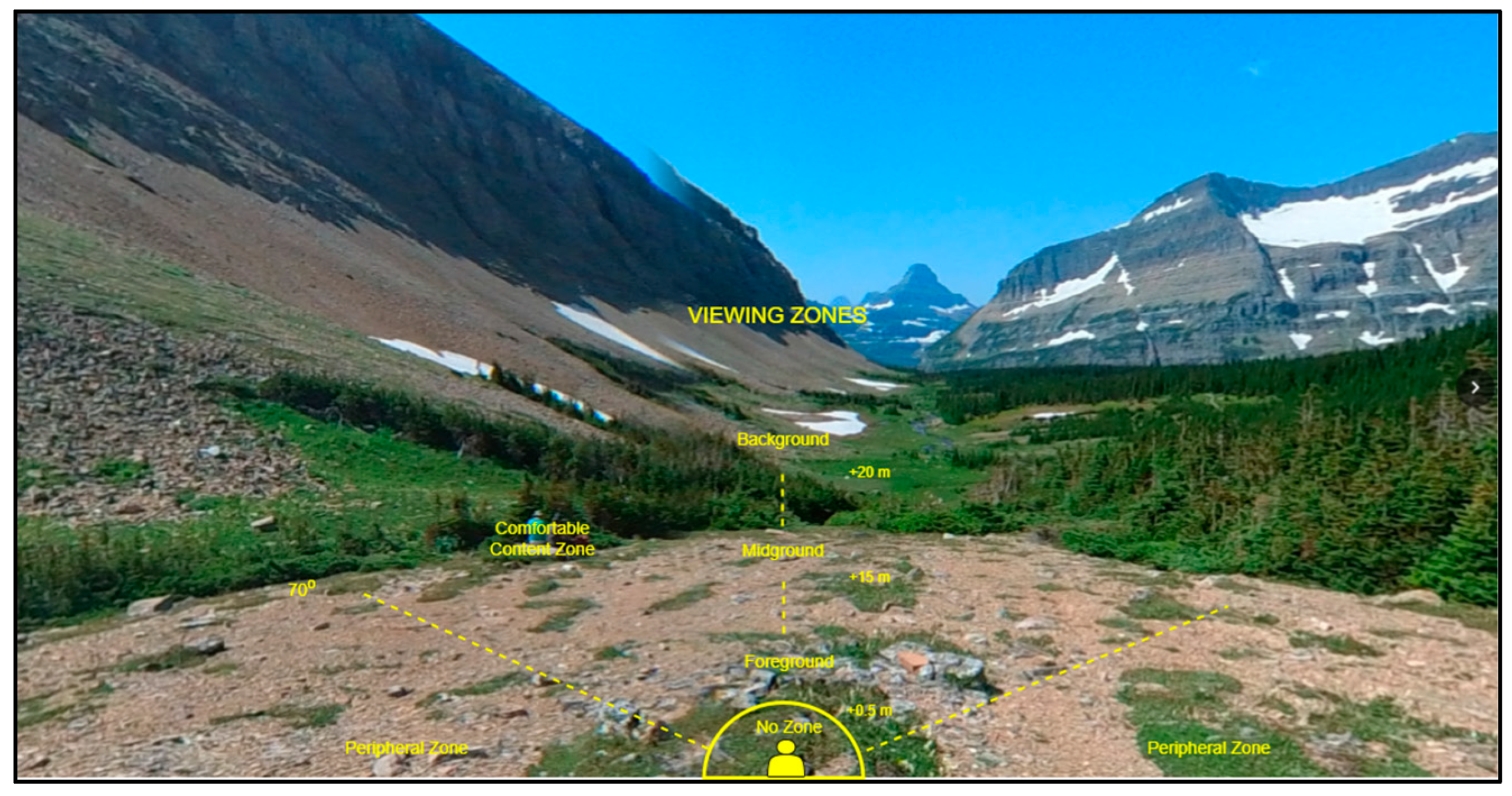
Visual patterns: perceptions of distance, scale, direction, orientation; mechanism for how to look aroundTo develop skills in visualizing and spatial reasoning.Spatial thinkingAccurate depiction of size, scale, and direction supports spatial fluency by providing opportunities to detect spatial patterns to support inference of driving natural processes.
Visual settingTo identify a compelling environment that invites engagement through interactions.Ludic Pedagogy Fun environments allow for exploration, freedom, and potential gamification.
Table 5. TREE-PG constructs within VRUI orders: 2nd Order.
VRUI Components:
Second Order
Goal of ComponentTREE-PG
Construct
Relevant Recommendations from the Construct
Instructional strategy;
social interactions
To collaborate with social partners in the learning environment to co-construct knowledge through shared language and interactionsSocial
constructivism
Learners must be provided opportunities to express thoughts through language with social partners in the learning environment. Knowledge is built and exists between social entities.
Instructional strategy; preconceptionsTo identify and address learner preconceptions to achieve deeper comprehension of topicsConceptual
change
Preconceptions must be elicited, confronted, and resolved (if needed) to avoid barriers to learning.
Instructional strategy;
learner perceptions
To develop a sense of belonging and help learners feel like valued members of the scientific learning communityAcademic
self-concept
Student perception of belonging will impact their ability to learn. During instructional interventions, students must feel like valued members of the scientific learning community.
Instructional strategy; language usedTo differentiate between colloquial and technical language to prevent misunderstandings in the learning processSystemic
functional
linguistics
Colloquial language may differ from technical language. A misunderstanding of language may impact the learning process.
Instructional strategy;
context of the instruction
To apply knowledge across various contexts with guidance from expertsSituated
cognition
Knowledge is context dependent. Instructional interventions should support novice learners with learning across multiple contexts with support of expert modeling.
Instructional strategy; reflection opportunitiesTo engage in activities and reflect to deepen their comprehension in knowledge acquisitionExperiential
learning
Instructional interventions must provide meaningful experiences for students to engage in knowledge development. Reflection must occur as a mechanism for integrating and solidifying knowledge.
Instructional strategy;
visual representations of knowledge
To use visualization, orientation, scale, and pattern to understand spatial relationships and natural processesSpatial
thinking
Instructional interventions should afford opportunities to depict size, scale, and direction. Knowledge is built when students detect patterns among spatial quantities to support inference of driving natural processes.
Instructional strategy; gamificationTo create fun and playful activities to boost learner motivation, engagement, and persistenceLudic
Pedagogy
Fun, positivity, play, and playfulness should drive the development of instructional interventions to make the learning environment more enjoyable and improve student motivation, engagement, and performance.
Table 6. TREE-PG constructs within VRUI orders: 3rd Order.
VRUI Components:
Third Order
Goal of ComponentTREE-PG
Construct
Relevant Recommendations from the Construct
Authentic contextsTo create activities that help learners feel they belong and are relevant to their interestsAcademic
self-concept
To persist in the discipline, students should feel like they belong. Extension, application, and transfer activities should reflect inclusive and authentic contexts that are meaningful and valued by the student.
Diversification of audience, context, and toneTo assist learners in practicing their knowledge for different audiences and situationsSystemic
functional
linguistics
Extension activities should support students with navigating changes in audience, context, and tone to enable the practice of translations of knowledge that will be required in authentic environments.
Reflective opportunities
for knowledge extension
and integration
To practice in various contexts and support learner reflection to apply what they have learnedExperiential
learning
Students should be provided with opportunities to practice knowledge in differentiated contexts. Reflection must be guided and scaffolded to transfer knowledge.
Opportunities to predict
and create explanations
using spatial patterns
To apply spatial concepts to build scientific reasoning skillsSpatial
thinking
Students should learn to use spatial concepts to develop normative scientific reasoning and knowledge.
Fun and gamified contextsTo create fun to boost students’ motivation to use what they learnLudic
Pedagogy
Student value of and motivation to transfer knowledge is dependent on perception of fun.
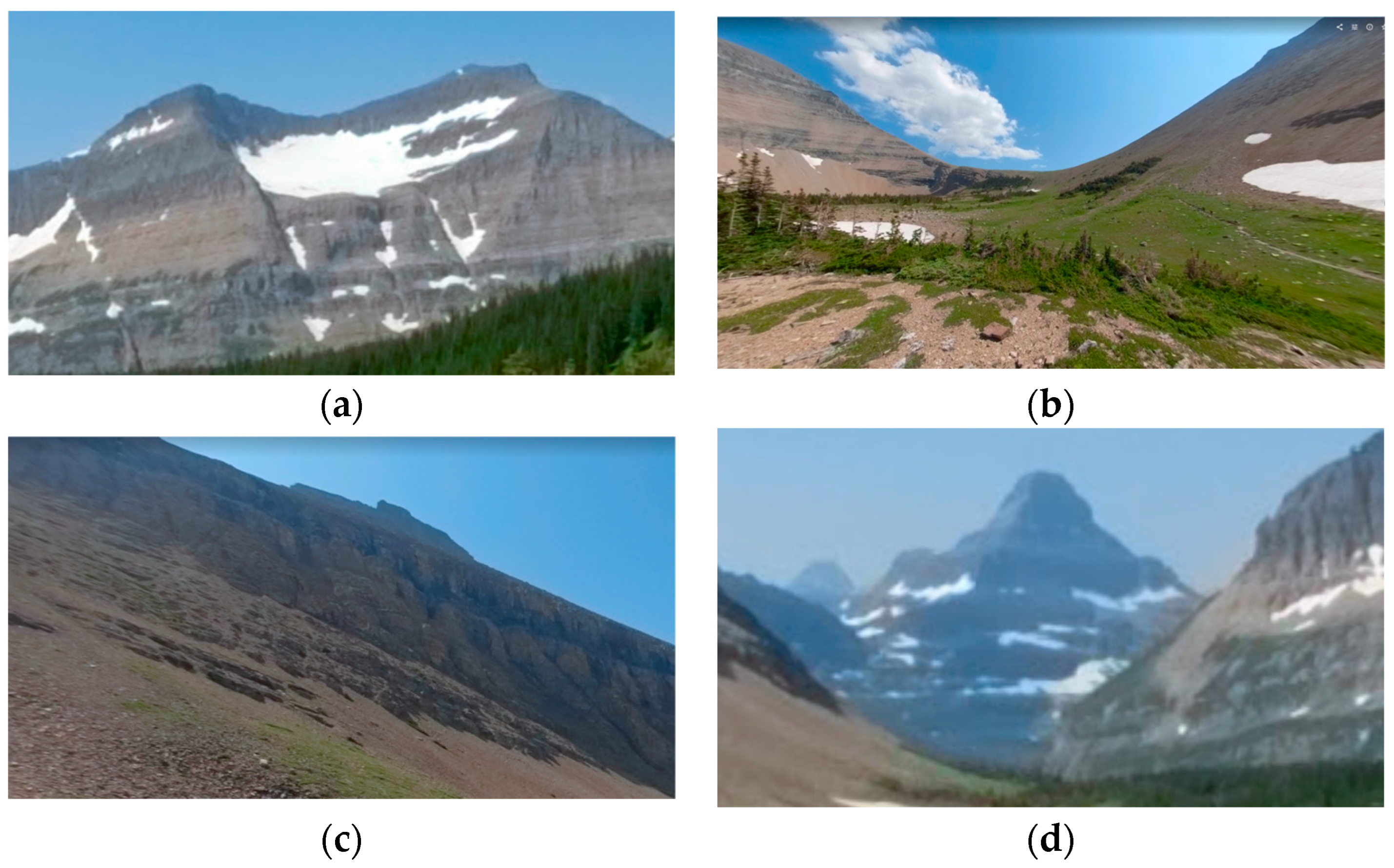
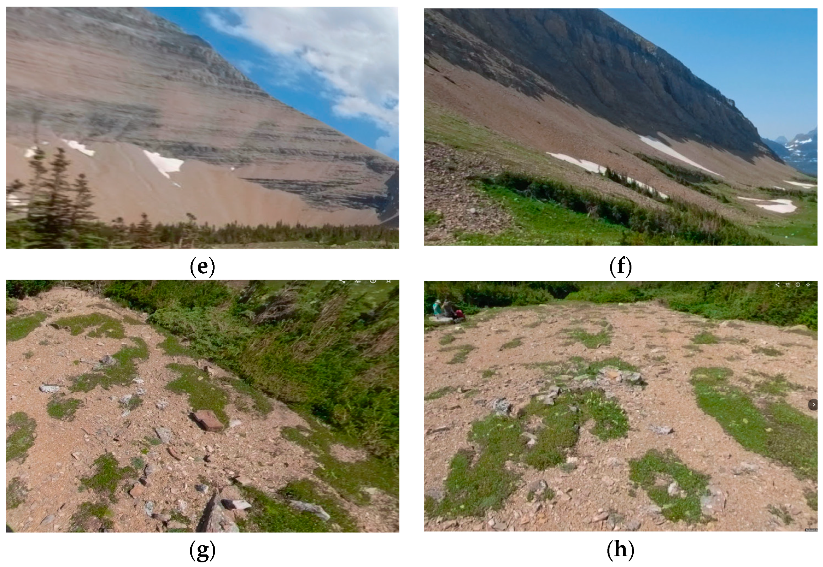
Table 7. Notes on glacial landscape change and the diverse features of a topographically complex glacier landscape.
Site of ViewshedGlacial and Periglacial Physical
Features
Examples to Support Students in Building Natural Hazard Assessment Skills
Preston Park, Siyeh Trail, GNPAlpine glaciers, cirque glacier (Piegan Glacier, as a complement to Sexton Glacier), classic horn shape (Mount Reynolds), arete, and evidence of the following: frost-shattering, frost heaving, periglacial ground, insolation, solifluction, unsorted patterned ground, cryoturbation, sporadic permafrost, talus slopes, avalanche boulder tongues, and U-shaped valley, and U-shaped saddle. Cirque glaciers are perched on the lip with the potential for rockfall and icefall. Rock avalanches. Potential for ice avalanches. Evidence of mountain glacier retreat. Changes in snow cover may impact plant or animal populations. Snow-blasting and plant winter injury.
Disclaimer/Publisher’s Note: The statements, opinions and data contained in all publications are solely those of the individual author(s) and contributor(s) and not of MDPI and/or the editor(s). MDPI and/or the editor(s) disclaim responsibility for any injury to people or property resulting from any ideas, methods, instructions or products referred to in the content.

