Essay

Peri-Urban Real Estate, Land-Use Changes, and Sustainability Challenges in Bangalore: Lessons from the Global South


by
Amrutha Mary Varkey
1,*,
Eby Johny
2 and
Jayakumar Chinnasamy
3
1
Faculty of Economic Sciences, University of Warsaw, Długa 44/bud. D, 00-241 Warszawa, Poland
2
Faculty of Political Science and International Studies, University of Warsaw, ul. Krakowskie Przedmieście 26/28, 00-927 Warszawa, Poland
3
School of Education and Social Sciences, University of West of Scotland, Import Building, 2 Clove Crescent, London E14 2BE, UK
*
Author to whom correspondence should be addressed.
Real Estate 2026, 3(1), 2; https://doi.org/10.3390/realestate3010002
Submission received: 11 December 2025 / Revised: 14 February 2026 / Accepted: 18 February 2026 / Published: 26 February 2026

Abstract

Peri-urbanization in rapidly growing cities of the Global South is increasingly driven not only by demographic growth but by escalating inner-city land and housing prices that push households and developers toward peripheral zones. Bangalore exemplifies this transition, where housing affordability pressures, speculative real estate investment, and weak land governance interact to transform agricultural landscapes into fragmented built-up clusters. Using satellite imagery (1991–2024), census data, and GIS-based land-use classification, this study quantifies peri-urban expansion across eight clusters in the Bangalore Metropolitan Region. The results show rapid built-up growth, agricultural land decline, and increasing spatial fragmentation, reflecting processes of extended urbanization beyond formal city boundaries. These transformations produce environmental stress, infrastructure deficits, and socio-spatial inequalities. The paper situates Bangalore within planetary urbanization debates and argues that peri-urban sustainability depends on land market regulation, spatial planning capacity, and data-driven governance.

1. Introduction

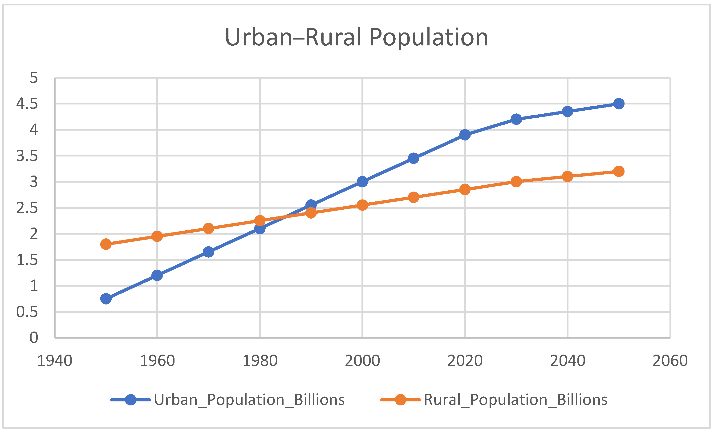
Urbanization in the 21st century increasingly unfolds beyond traditional city boundaries, producing hybrid peri-urban landscapes that blur rural–urban distinctions [1]. This process is especially pronounced in the Global South—here referring to rapidly urbanizing regions of Asia, Africa, and Latin America characterized by compressed urban transitions, infrastructural deficits, and governance constraints [2,3]. Globally, the share of people living in urban areas continues to rise (Figure 1). Globalization has led to rapid urbanization, which has significantly altered the suburban environment, primarily through the expansion of urban areas—a central feature of modern urban development [4,5,6]. Urban development causes rapid changes in suburban areas, and peripheral urban areas are gradually integrated into core urban areas, complicating spatial management and creating serious challenges for decision-makers in urban planning [7,8]. Population growth rates in cities in developing countries are higher than those in rural areas, increasing pressure on suburban areas [9,10,11]. By 2050, 70% of the world’s population is expected to live in urban areas, primarily in developing countries [12]. This study demonstrates that the sustainability of inhabited suburban areas depends on a deeper understanding and management of land-use change.
Figure 1 shows the global rural and urban populations from 1950 to 2050. The urban population is projected to increase steadily to 4.5 billion by 2050. The rural population trend shows a much more stable demographic pattern. The narrowing gap between rural and urban populations indicates the global urban transition. Peri-urbanization is a critical aspect of urban development and regional planning, particularly in rapidly urbanizing regions such as the Global South. However, despite extensive studies on urban expansion, a significant research gap persists in understanding the nuanced drivers of land-use change in the peri-urban areas of Indian cities, particularly in the case of Bangalore. This gap encompasses the interactions between rapid population growth, industrial development, and environmental sustainability challenges specific to these regions. This phenomenon is observed in other Asian countries, including China, as well as in African contexts such as Ghana and Lagos [13,14,15,16]. Urban areas are largely driven by technological industries, innovation, and knowledge-based activities [17], and Bangalore is an example of industrial growth, IT developments, and rapid real estate developments.
In Bengaluru, foreign capital has primarily flowed into IT parks and gated housing developments along the Outer Ring Road, illustrating both infrastructure improvement and socio-spatial segregation [18]. Administrative definitions often underestimate functional urbanization, excluding peri-urban zones where rapid land conversion is occurring. These areas represent key sites of extended urbanization, where urban processes operate beyond metropolitan cores [19]. Peri-urban growth is frequently attributed to population pressure. Yet housing affordability and land-price gradients are equally critical: as central land prices rise, development is displaced outward [20]. This market-driven outward shift reshapes land systems, particularly in fast-growing service economies.
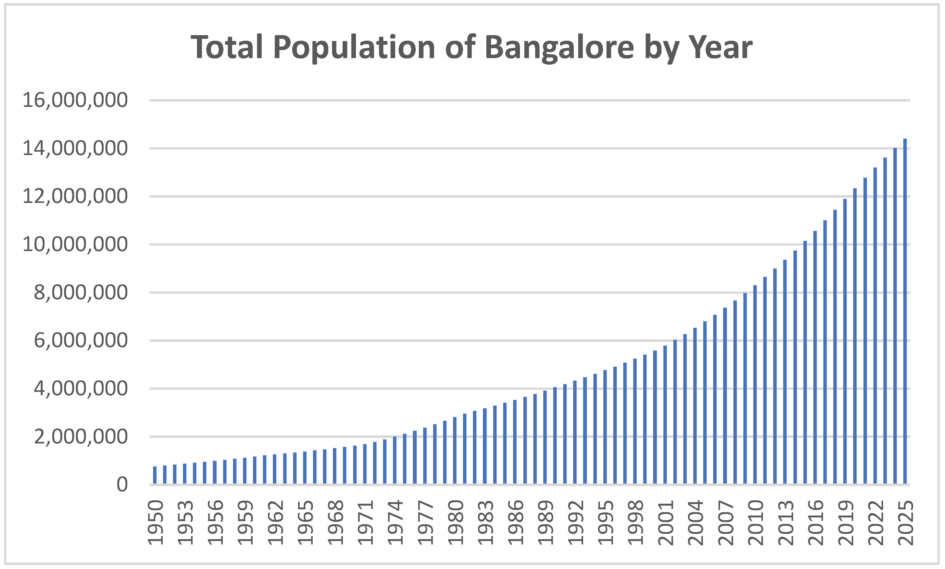
Bangalore’s transition from a public-sector city to an IT-led global hub since the 1990s has generated rapid housing demand, real estate speculation, peripheral industrial corridors, and the decline of agricultural land [21]. Unlike European cities whose urbanization unfolded over centuries, Bangalore’s transformation has occurred within three decades, with rapid population growth (See Figure 2), producing governance strain and environmental pressures. Rapid urbanization leads to the growth of informal settlements, land-use changes, and the expansion of peri-urban clusters. Postmetropolis is a common scenario in urban development across many metropolitan cities [22]. Bangalore city development also shows a pattern of postmetropolis and edge city development.
In the Global South, Bangalore is one of the fastest-growing peri-urban settlements. This article analyses the dynamics of land-use change and sustainability challenges in the urban areas of Bangalore. Second, it evaluates the responsiveness and adequacy of the current planning framework and policy interventions in addressing changing urbanization patterns and increasing real estate development. It analyzes the broad implications for sustainable urban development resulting from unorganized city planning, which leads to a changing urban environment. Marginalized and low-income communities are disproportionately affected by these threats, as inadequate drainage systems and informal housing increase the risk of flooding. Peripheral apartments often lack the infrastructure and services available in central urban areas, resulting in disproportionate maintenance costs that increase vulnerability. As a result, low-income neighborhoods face public health risks, including poor sanitation and hygiene. These challenges are compounded by the continued neglect of urban planning institutions and limited institutional support for sustainable housing development. Infrastructure, socioeconomic, and administrative factors combine to increase risk and reduce the resilience of vulnerable groups. And this study answers the following research question. How does peri-urban transition drive real estate development and sustainability challenges associated with land-use changes in Bangalore, and what are the strategies for planned urban development?
The rest of the paper is organized into the following sections. Section 2 reviews the literature on environmental narratives of peri-urbanization in Bangalore and the Global South. Section 3 outlines the methods and conceptual framework of the analysis of the peri-urban transition. Section 4 describes the empirical analysis of peri-urban Bangalore with secondary spatial data analysis. Section 5 examines strategic implications for planned urban development, and the paper concludes with key policy insights.

2. Literature Review

2.1. Environmental Narratives of Peri-Urbanization in Bangalore and the Global South

Accelerated urbanization in these regions highlights opportunities for economic growth and employment, as well as significant risks to environmental sustainability [23]. Unregulated land-use transformation has substantial implications for environmental quality, especially in expanding metropolitan areas [24,25,26]. Examples such as the Yangtze and Pearl River Deltas in China demonstrate the challenges of balancing rapid development with sustainable management [27]. In Bangalore, unregulated city planning is evident, largely due to corruption within the government structure and its institutions [28]. In Bangalore, the dynamics and drivers of peri-urban land-use change, the resulting sustainability challenges, and the need to address sustainable and environmentally friendly city planning gaps are evident in the peri-urban transition from 1991 to 2024.
Peri-urban development has addressed sprawl and land-use changes; however, scant attention has been paid to developing methodologies for quantifying sprawl [29]. Peri-urban growth varies significantly across regions and cannot be understood in isolation from the larger metropolitan context. While the existing literature primarily discusses land use from a GIS-based geographic perspective, it lacks an adequate discussion of Bangalore’s development perspective regarding the peripheries of urban areas, particularly concerning specific examples of industrial and IT development after 1991. To address this gap, this paper proposes the use of specific indicators such as land-use density, spatial fragmentation, and accessibility indices to quantify sprawl in the Global South. Land-use changes impact biophysical processes, contributing to climate change, biodiversity decline, and alterations in sustainable development [30,31]. Agricultural land conversion processes lead to urbanization in the peripheries of cities [32,33] and result in changes to biodiversity that require planning attention in city development [34,35]. The Global South, in particular, suffers from poor city planning and sprawling development, leading to biodiversity loss and environmental degradation due to unplanned construction and inadequate land-use planning.
In South Asia, urban sprawl is closely linked to demographic pressures and industrialization, as seen in Bangalore. The expansion of the IT Corridor and related industrial development has significantly intensified peri-urban land-use change in Bangalore’s metropolitan area [4]. In contrast, cities like London and Paris are examples where strong regulatory frameworks mitigate environmental impacts. For instance, in Paris, strict zoning laws and green infrastructure policies have helped maintain urban sprawl within limits, while in London, detailed regional planning has kept land-cover loss minimal. On the other hand, Bangalore experiences unregulated expansion, leading to substantial land-cover loss and environmental degradation.
This contrast illustrates the critical role of regulatory frameworks in guiding peri-urban land-use change. Spatial transition is a global phenomenon that varies across different geographic regions. Cities in the Global South, including Bangalore, are transitioning with a distinct pattern of migrants moving from rural villages to urban areas. Studies show that urbanization patterns involve massive migration of rural populations into cities [36,37,38]. Bangalore attracts businesses and investment to its outskirts, seeking affordable land with expansion potential. Bangalore has witnessed structural changes, leading to a service-led economy in the 21st century. The city’s transition to an IT service-sector hub has led to the periphery being associated with environmental problems and poor planning [39].
Bangalore exemplifies a unique pattern of urban sprawl in the Global South, characterized by peri-urban clusters and rapid industrial growth, with distinct differences in development patterns and land administration. Globally, land-use changes are transforming environments at an unprecedented pace, driven by both natural and anthropogenic factors. Interactions between biophysical and human systems accelerate these changes [40]. Such land-use transitions contribute to farmland deterioration, rendering fallow land unsuitable for cultivation due to intensive human activity [41]. These rapid environmental changes have led to significant socioeconomic and ecological shifts within the rural–urban continuum [42].
Land-use changes affect the ecosystems of peri-urban areas [43]. Land-use conversion in peri-urban Bangalore has disrupted the interconnected wetland while simultaneously fragmenting agricultural landscapes. Such ecological degradation illustrates the environmental externalities embedded in infrastructure-led and speculative real estate expansion. The densification of metropolitan areas directly impacts quality of life by reducing greenery and hindering environmental services [44]. Peri-urban areas are often more dynamic than planned development zones. This creates significant land-allocation problems related to the management of green cities and agricultural land use. The adverse effects include loss of agricultural land, changes in land cover, and environmental degradation in the growing peripheries of Bangalore. This is a common scenario in growing cities in developing countries. These fringe areas in the Global South have ample scope for expansion. Industries are located near growing peripheries in metropolitan areas such as Bangalore, Chennai, and Delhi, offering employment opportunities in emerging tech jobs and businesses. Accessibility to markets, expansion of services, industries, trade, and finance are reasons people choose the periphery of existing cities [45,46].
Peri-urban areas attract people due to their easy access to cities, low living costs, and access to urban facilities [47]. The benefits of both rural and urban amenities can be enjoyed while living on the city’s outskirts at a lower cost. Peri-urban areas are considered desirable places to live [48]. For instance, a survey conducted in Bangalore revealed that approximately 65% of recent settlers in peri-urban zones cited lower housing costs and improved living conditions as their primary reasons for moving. Migration figures also indicate a 15% annual increase in population in these areas over the past five years, highlighting the socioeconomic pull factors. Moreover, economic and environmental factors trigger dynamic changes in the periphery. Defining the boundaries of city peripheries remains a challenge for administrators, as the transition is dynamic and volatile.
Rapid urbanization in the Global South is typically characterized by sprawling urban growth patterns [49]. The decline of agricultural land often coincides with the expansion of diverse urban land uses. Human activities exert considerable influence on the landscapes of emerging South Asian cities. In contrast to European countries such as Sweden, Denmark, and Germany, many developing nations lack the infrastructure and resources required for effective land-development planning. Land-use deficiencies negatively impact sustainability and regional climate [50].
The development of industrial clusters in peri-urban areas of the Global South has facilitated the relocation of pollution-intensive industries from urban cores, resulting in significant environmental pressures. Polluting industries are concentrated in Bangalore’s peri-urban industrial estates such as Peenya and the Bommasandra–Jigani belt, while the Outer Ring Road–Whitefield IT Corridor growth pole has expanded along the eastern periphery, where downstream systems (e.g., Bellandur Lake) receive loads of domestic sewage and industrial effluents, underscoring the city’s peri-urban environmental pressures. In Delhi, the concentration of industrial activities within peri-urban zones has been shown to exacerbate environmental degradation and human health risks [51]. Similar patterns are observed in the development of the Rajiv Gandhi Technology Park in Chandigarh [52] and Hitec City at the margin of Hyderabad [53], where inadequate planning and regulatory oversight have resulted in heightened levels of pollution and resource conflicts. In contrast, peri-urban transitions in cities such as Stockholm and Berlin are characterized by stringent land-use regulation and comprehensive environmental governance, which mitigate adverse impacts and promote sustainable urban–rural linkages [54]. The divergent experiences of these global cities underline how context-specific governance structures influence outcomes: while many cities in the Global South grapple with escalating land and water conflicts, diminished agricultural productivity, and eroded livelihoods due to uncoordinated peri-urban expansion [55], cities with proactive policy frameworks often achieve more balanced socio-ecological transitions [56,57].
Historical analysis of land-use change further reveals that the absence of effective policy management in the Global South perpetuates exclusion, environmental injustice, and hinders progress toward the Sustainable Development Goals [58,59]. However, there are notable examples of successful governance experiments in the Global South. In Curitiba, Brazil, innovative urban planning and strong public transit policies have effectively curbed urban sprawl while preserving green spaces and improving residents’ quality of life. Accordingly, there is a pressing need for adaptive, context-sensitive policies that can address the multifaceted challenges of peri-urban sustainability in rapidly transforming environments.
Precise land-use and land-cover data are crucial for effective land-use planning and landscape simulations [60,61,62,63], which highlight ongoing environmental degradation. Land-use changes have a substantial impact on urban sustainability, particularly when governance is inadequate. Although urban authorities attempt to promote planned development, the scale and pace of peri-urban transitions in metropolitan cities of the Global South remain largely uncontrollable and unpredictable.
The preceding analysis yields several targeted policy recommendations to address the sustainability challenges associated with peri-urban land-use change. First, municipal governments should formally integrate the peri-urban interface (PUI) into statutory urban master plans. This integration must be operationalized through the delineation of clear peri-urban boundaries and the establishment of land-zoning ordinances that restrict unregulated development and prioritize ecologically sensitive areas, to be implemented within a five-year framework. Second, urban planning frameworks in the Global South should be restructured to incorporate adaptive, participatory, and multi-level governance mechanisms. State agencies should champion these reforms, ensuring the decentralization of planning authority, incorporation of community feedback processes, and regular review cycles that account for the rapid demographic and economic shifts characteristic of these regions, assessed annually. Third, to address persistent issues of land fragmentation, property disputes, and tenure insecurity, governments should establish robust land-registration systems underpinned by digital cadastral mapping and streamlined adjudication procedures.
The responsibility falls on national land agencies to implement these systems over the next three years. The deployment of geospatial technologies, including GIS and high-resolution remote sensing, should be institutionalized for ongoing monitoring of land cover and urban expansion patterns [4,64,65]. Fourth, tailored policy interventions must equip local planning authorities with the resources and technical expertise necessary for effective peri-urban management. This action should be supported by community bodies and implemented in coordination with capacity-building initiatives, coupled with legislative mandates for regular data-driven environmental assessments. Ultimately, interdisciplinary research collaborations are necessary to facilitate longitudinal analysis of land-use transitions, thereby providing policymakers, planners, and farmers with empirically grounded guidance. By implementing these recommendations, urban and regional planning authorities will be better positioned to reconcile developmental imperatives with long-term environmental sustainability.

2.2. Peri-Urbanization in the Global South

In suburban areas, especially in the Global South, urbanization often outpaces the ability of local management systems to effectively manage land-use changes. In suburban areas around Indian cities, the process of urbanization is manifested in the systematic transformation of agricultural land and small-scale real estate into residential, commercial, and infrastructure spaces. This not only disrupts existing socioeconomic structures but also increases competition for resources, leads to environmental fragmentation, and heightens exposure to environmental threats. Therefore, suburban areas serve as key sites for monitoring and analyzing the complex interaction between changes in land structure, increasing population pressures, and management deficiencies, all of which have far-reaching implications for urban sustainability. The eight peri-urban clusters of Bangalore exhibit rapid corridor-led expansion and the irreversible conversion of agricultural land, thereby compounding ecological vulnerabilities [66]. These patterns underscore the sustainability challenge of managing speculative real estate growth, with long-term implications for environmental challenges across the metropolitan region [4,67].
Rapid population growth leads to faster urbanization [27]. Population growth and urbanization are predicted to continue into the twenty-first century, bringing an additional 2.5 billion people into the world’s urban population by 2050, with nearly 90% of this growth concentrated in Asia and Africa [68]. This demographic shift is accelerating profound and ongoing changes in the suburban landscape, particularly in the Global South. The environmental impacts of urbanization, including environmental degradation and spatial segregation, are increasingly visible at the peri-urban interface [69,70,71]. South Asia, which accounts for 17.7% of the world’s population, exemplifies the serious challenges posed by land fragmentation as a result of development. Urban areas are under pressure to maintain environmental sustainability while experiencing rapid urban development.
India’s urban population increased from 17.92% in 1960 to 36.86% in 2024, reflecting rapid urbanization and significant changes in land use. This growth has transformed cities, shifting livelihoods from agriculture to industry and services. However, urbanization-driven land-use changes have contributed to environmental decline, including the loss of land cover and biodiversity [72]. Urban expansion often results in land conversion [73], and its spatiotemporal patterns further impact the environment and land cover.
Land-use changes in rapidly urbanizing environments precipitate a range of challenges, including increased climate variability, land degradation, water scarcity, and the proliferation of unplanned developments, particularly at urban peripheries in the Global South. The term ‘Global South’ is used here to refer to rapidly urbanizing regions in Asia, Africa, and Latin America characterized by late but accelerated urban transition, infrastructural constraints, and governance challenges. Rapid urbanization in the Global South is a significant driver of such unregulated expansion, and spatial transitions manifest differently across geographic regions.
In this context, cities in the Global South, such as Bangalore, are characterized by pronounced rural-to-urban migration patterns. In China, urbanization historically involved large-scale rural migration [74]; however, the implications for migrants in the Global South require critical examination. Migrant populations relocating to Bangalore frequently settle in peri-urban zones where affordable housing is accessible, though this often entails precarious living conditions, limited social infrastructure, and dependence on overcrowded, inefficient public transport systems. These extended commutes and infrastructural deficits not only heighten socioeconomic vulnerabilities but also influence patterns of spatial segregation and access to urban opportunities. At the same time, investment-driven land acquisitions in fringe areas accentuate urban sprawl and can displace both long-term residents and recent migrants. The interplay between the everyday experiences of migrants—marked by spatial marginalization—and speculative investment activities contributes fundamentally to the evolving spatial morphology of Bangalore. This underscores the imperative for comprehensive urban planning strategies that prioritize equitable access and sustainable development. Indeed, the dynamic and often unregulated transformation of peri-urban spaces is strongly associated with escalating environmental degradation and persistent deficiencies in planning [39].

3. Methods and Conceptual Framework

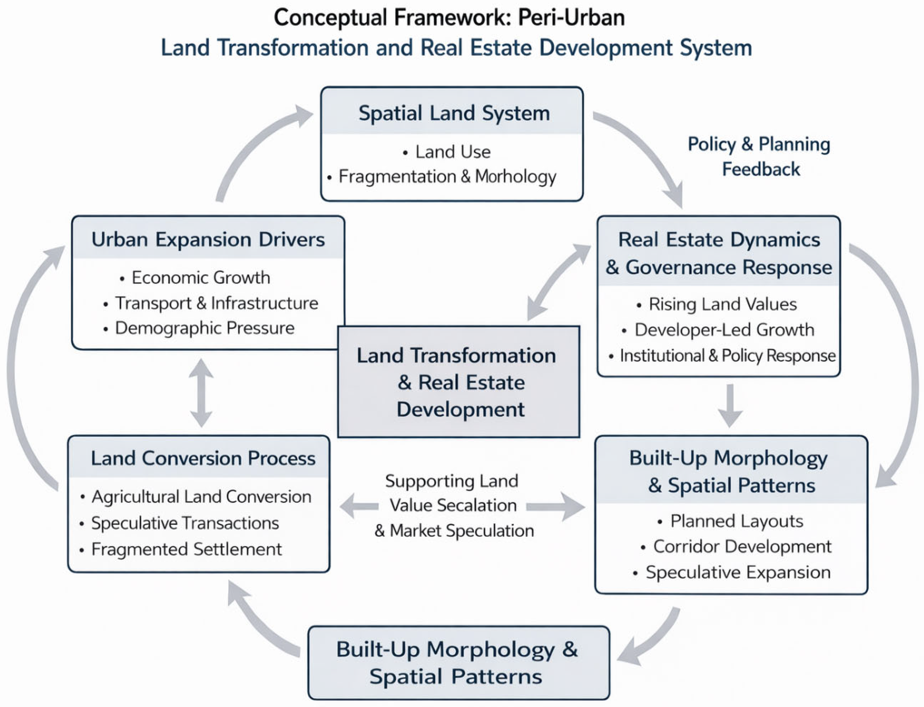
This study uses a perspective approach to examine the relationship between peri-urban real estate development, land use, and sustainability challenges in Bangalore. This study synthesizes empirical and policy literature reviews and land-use images using Google Earth Pro and Thematic Data (NRSC/ISRO), retrieved from Bhuvan, to contextualize the peri-urban transformation in the Global South. The conceptual framework illustrates the transformation of peri-urban areas as a dynamic interaction between market forces, real estate development, and governance. This framework presents the transitional nature of the peri-urban, driven by demography, infrastructure growth, and economic growth. Land conversion is not linear and often leads to speculation, land fragmentation, and dense real estate development in the peripheries (Demiroğlu İzgi, 2024). Peri-urban land conversion for real estate is shaped by the accessibility and expectations of consumers rather than efficient land uses [75,76].
The feedback loop in this framework (See Figure 3) shows that built-up morphology and real estate reshape urban expansion. Land conversion in the periphery leads to gated communities and the growth of transport corridors as manifestations of real estate growth. This drives real estate prices and infrastructural developments. These institutional responses transform accessibility, feasibility, and regulations, feeding back into the spatial land system and land conversion. This cyclical process of urban development considers peri-urbanization as a market-led process rather than a planned expansion of the city to the peripheries [77,78].

Data Sources

Urban sprawl was quantified using secondary sources of geospatial datasets. This study used the Bangalore Urban Land Use, 2017 dataset and the Peripheral Ring Road alignment, accessed via Google Earth Pro and thematic layers from Bhuvan—Thematic Data (NRSC/ISRO). The land-use layer was spatially overlaid with the Peripheral Ring Road corridor to delineate peri-urban zones situated outside the statutory municipal boundary but within the infrastructure’s functional influence area. The datasets were officially generated and validated by NRSC/ISRO; no additional ground-truthing was performed. The methodological approach is defined as secondary spatial data analysis aimed at quantifying patterns of urban sprawl in Bangalore.

4. Spatial Analysis of Peri-Urban Bangalore

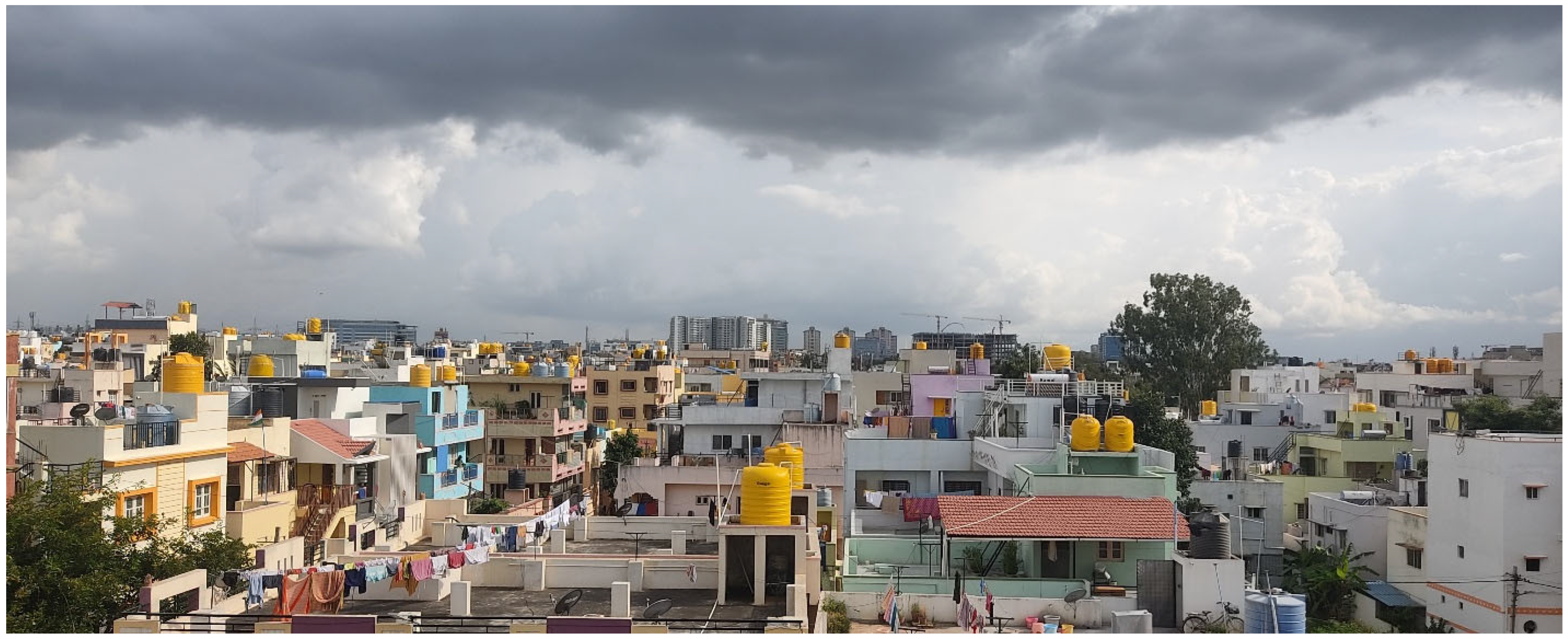
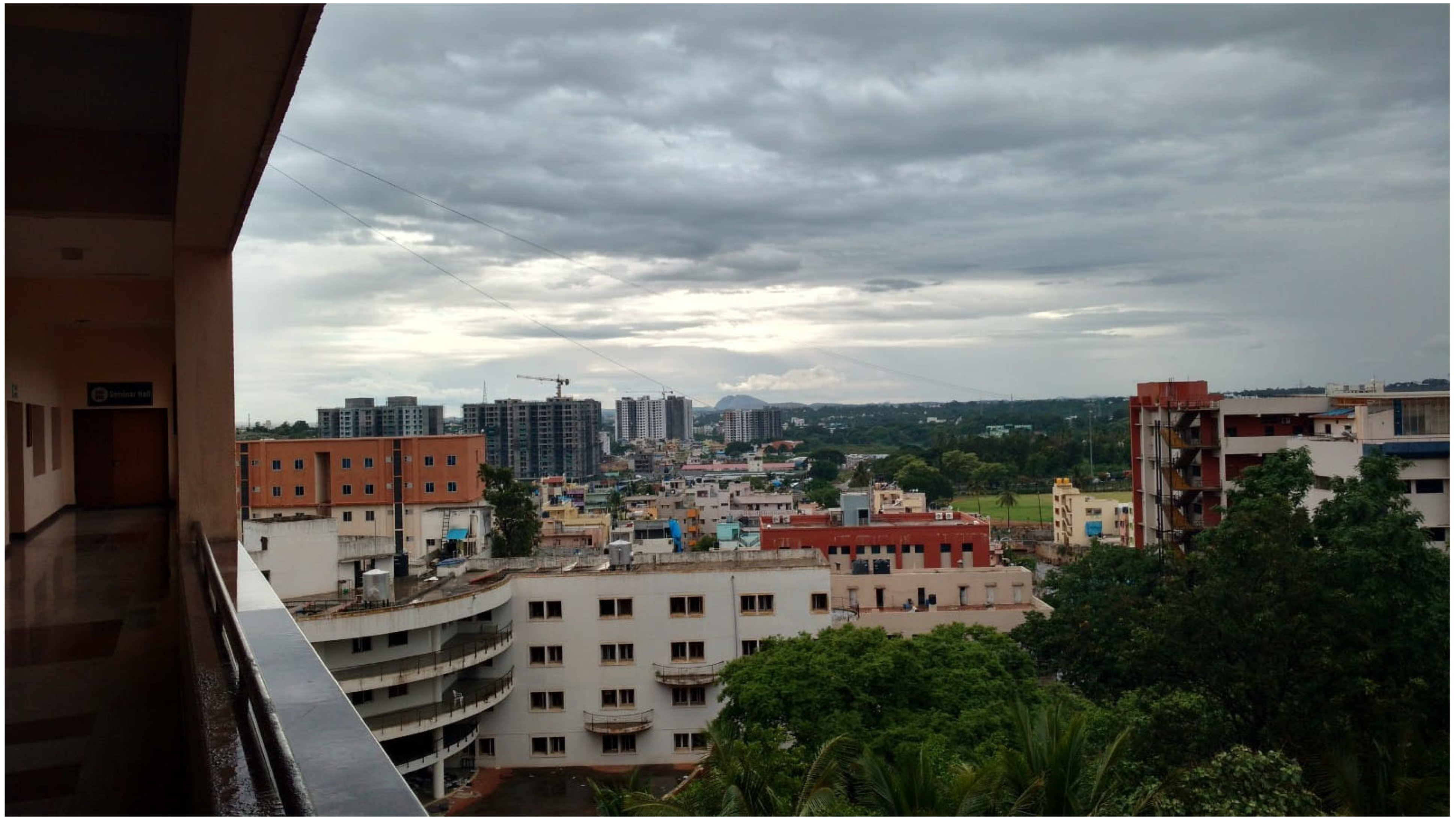
Urban transformation in cities across the Global South is occurring at a rapid pace, primarily driven by significant population growth. In South Asia, the accelerated expansion of urban areas is particularly evident, largely resulting from increased population densities and ongoing industrialization. Urbanization in cities such as Bangalore is shaped by several interrelated factors, including the expansion of the Information Technology (IT) corridor, IT-stimulated real estate development, and broader industrial growth [4]. Recent studies indicate that Bangalore’s population expanded by nearly 50% between 2011 and 2021, while the city’s green cover diminished by approximately 70% during the same period [79]. These trends present a marked departure from patterns observed in metropolitan areas such as London or Paris, which have managed urban influxes and resource demands more effectively, thereby sustaining more stable land-cover conditions. Bangalore, a large urban area located on the outskirts of a major city (Figure 4 and Figure 5), is generally characterized by commercial activities, shops, entertainment venues, and residential areas. This is a formal form of edge city developments.
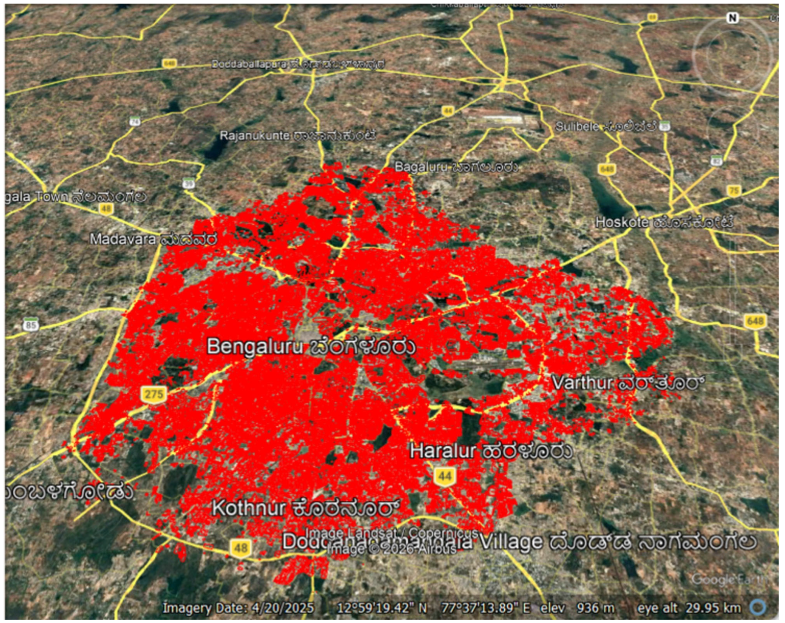
Figure 6 illustrates the spatial footprint of built-up expansion (in red) extending the administrative boundary of the city of Bangalore into surrounding peri-urban zones, diffusing rapid real estate development. This growth leads to rapid changes to the peripheral networks, depicting the integration of rural settlements into the urban core. This often leads to unplanned growth, pressure on land resources, and long-term sustainability challenges of land-use planning [80].
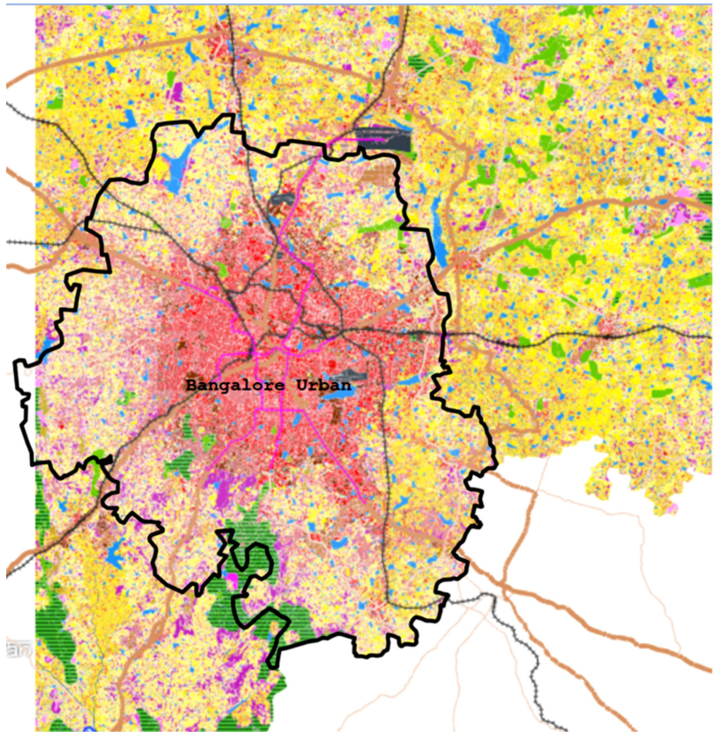
Figure 7 shows a dense concentration of built-up land (shown in red) in the Bangalore urban boundary radiating towards major transport corridors—the ring roads into agricultural lands of the periphery. The peripheries display fragmented land uses, where real estate-driven conversion spreads through vegetation (green), water bodies (blue), and agricultural land (yellow), indicating even spatial transformation. This pattern shows corridor-based urban expansion intensifying ecological pressures and highlighting sustainability challenges at the urban fringe.
Bangalore exemplifies a distinctive pattern of urban sprawl within the Global South, characterized by the proliferation of peri-urban clusters and accelerated industrial expansion. These dynamics are shaped not only by the city’s rapid economic growth but also by variations in land administration and planning practices compared to other cities experiencing similar pressures. This localized manifestation of urbanization aligns with broader global trends in land-use change, which are transforming the environment at an unprecedented scale due to the interplay between biophysical and anthropogenic factors [81]. As seen in Bangalore, intensified human activity precipitates the degradation of agricultural land, rendering fallow areas increasingly unsuitable for cultivation [82]. These land-use shifts, situated within the broader rural–urban continuum, contribute to the profound socioeconomic and ecological transitions observed both locally and globally [83]. The case of Bangalore thereby offers insight into how specific urban trajectories within the Global South both reflect and inform global patterns of land transformation and urbanization.

5. Discussion: Strategies for Planned Urban Development

5.1. Income Generation

Cities serve as key centers for income generation, attracting people seeking better living conditions and economic benefits [84]. In India, financial aspirations and social status—shaped by the caste hierarchy—drive migration to cities and influence individuals’ potential for success. Urban planning often reinforces these social divisions, with subaltern areas of cities allocated to lower-income and marginalized communities [85]. As a result, marginalized groups face persistent socioeconomic injustice and structural inequality, making it difficult for them to achieve the Sustainable Development Goals. Living conditions and educational opportunities are usually poorer in these areas, and political caste elites often benefit from the continued marginalization of these communities, such as those in Bangalore. Rapid built-up growth in Clusters 3 and 5 corresponds with agricultural land loss (Figure 4), indicating weak zoning enforcement.
Income and urban development are closely associated within the context of developing countries. Wage increases improve individuals’ living standards, while lower-income individuals face limited budgetary resources to support their quality of life. Cities often develop within a context of inequality. In the Global South, this is clearly evident in the subaltern areas of cities. Higher-income communities often have better living conditions and greater access to educational opportunities due to their higher incomes. This income division strongly influences urban planning. In cities, especially in more prominent areas, residents often feel more positive about the Sustainable Development Goals. These areas continually strive to improve compared to other parts of the city due to the influence of political elites, high-income communities, and social status.

5.2. Planned Real Estate Growth

Real estate demand tends to be income-elastic, especially in growing economies. In Bangalore, the pattern of city expansion and real estate pricing is evident. Income generation has created a higher demand for land and real estate, leading to increased prices. Real estate price inflation may be of less concern in cities in more developed countries because they are already fully or almost fully urbanized, and their expansion is rarely accompanied by urban population growth [23]. During a recession, the real estate market declines due to lower individual incomes and uncertainty about job security. This eventually affects the construction industry and job creation in the city’s development [86,87]. Note that land-use regulations decrease the price elasticity of housing supply and generate higher housing prices. While overly restrictive regulations may reduce housing supply elasticity, well-designed and infrastructure-coordinated planning systems can enhance supply elasticity by ensuring the timely provision of services and development-ready land.
The real estate sector is a major driver of city development, primarily through its role in infrastructure construction, which is largely driven by private investors seeking high returns [88]. While real estate investment accelerates city growth, the main motive is financial gain rather than environmental responsibility. This focus creates tension with society and government, which raises concerns about accountability and environmental sustainability. Ultimately, real estate expansion significantly shapes urban infrastructure and land acquisition patterns.

5.2.1. Sustainable Infrastructure Expansion

As real estate development increases, cities expand and promote infrastructure such as roads, metro systems, public transportation, utilities, and services to support new residential, commercial, and industrial properties. Sustainable infrastructure expansion in Bangalore city is vital for supporting economic growth, environmental protection, and improving connectivity. Significant investments have been made in transportation, green energy, and telecommunications to facilitate trade and enhance the quality of life. Projects like highways, metro systems, and smart cities aim to boost accessibility and efficiency.

5.2.2. Economic Aspirations

Real estate investment generates jobs during construction and attracts local businesses, boosting communities and increasing income levels for residents. Bangalore City Corporation has an economic aspiration, which is reflected in its goal to become the largest revenue-generating metropolitan city in India. This ambition drives policies focused on boosting manufacturing, technology, and services. The government encourages entrepreneurship and innovation, crucial for generating employment and increasing revenue.

5.2.3. Urban Density and Land-Use Allocation

Real estate developments promote higher urban density, making cities more efficient and sustainable by optimizing land use. Urban density in Bangalore City is a challenge, frequently resulting in congestion and inadequate service provision. Urban flooding is a part of daily city life during the monsoon season in Bangalore, and the repeated flood alerts undermine progress toward achieving the Sustainable Development Goals (SDGs). During the monsoon season, urban flooding has become a recurring feature of daily life in the city, and repeated flood alerts undermine progress toward achieving the Sustainable Development Goals (SDGs).
Effective land use allocation is essential for sustainable urban planning. Strategies include mixed-use developments and zoning reforms to maximize land productivity and proper drainage and waste management while ensuring adequate housing and amenities.

5.2.4. Attracting Investment and Talent

Modern, well-planned real estate developments attract investment, a skilled workforce, and entrepreneurs, fostering innovation and economic growth. To foster growth, Bangalore City actively works on attracting investment and talent. Initiatives like green city development aim to create a favorable business environment. Streamlining regulations and improving ease of doing environmental supporting business have made the city an appealing destination for both domestic and foreign investors.

5.2.5. Improved Living Standards

Better housing options and urban amenities improve quality of life, making cities more attractive for residents and businesses. Improved living standards are closely linked to real estate development in India. As infrastructure and urban planning advance, housing projects cater to diverse demographics, providing affordable housing and enhancing community facilities. This growth not only boosts the economy but also raises the quality of life for residents. Marginalised communities face significant gaps in the achievement of the Sustainable Development Goals (SDGs). However, well-regulated market mechanisms, implemented through government and public–private partnerships, can enhance the provision of affordable housing for these communities in urban areas.

5.2.6. Revitalization of Areas

Real estate growth can lead to the revitalization of underdeveloped or declining neighborhoods, enhancing overall city development. Revitalization of areas involves comprehensive urban redevelopment, improving infrastructure, and enhancing public spaces. This process aims to rejuvenate neglected zones, attract residents and businesses, and create vibrant community hubs. Projects often focus on restoring historical sites, improving safety, and promoting sustainable practices, ultimately fostering a sense of belonging.

5.2.7. Increased Tax Revenue

Rising property values and new developments increase city revenues, enabling further investment in public services and infrastructure. Increased tax revenues result from successful real estate growth, as enhanced infrastructure and improved living conditions boost property values and economic activity. As businesses flourish and more residents move into revitalized areas, local governments benefit from higher property taxes, stamp duty and sales tax collections. This additional revenue can then be reinvested in public services, further contributing to community development and economic growth.

6. Policy Recommendations and Technical Interventions

6.1. Innovation in Peri-Urban Development

It is necessary to integrate the framework of innovation and international cooperation on sustainable development through FDI in city planning in both the Global South and the West, promoting cross-departmental data sharing and community engagement. East Asian countries have achieved tremendous growth in environmental city planning. Investment from China, South Korea, Japan, and Singapore will create better opportunities for peri-urban expansion through proper real estate management. The case of Bengaluru shows that real estate growth needs to be coordinated with the SDGs to achieve responsible urbanization through technological innovation and institutional constraints. The CA-ANN model has emerged as a useful tool for predicting trends in urbanization and identifying critical hotspot locations [89].
This plan can optimize land use while promoting both development and ecological interests. Promoting integrated innovation between urban and suburban areas hinges on removing obstacles to the flow of factors of production between urban and peri-urban areas, allowing industries, talent, and data to circulate smoothly between the two. Urban–peri-urban integration has significantly improved the investment environment by breaking down the urban–rural divide, improving infrastructure, promoting land system reform, and facilitating data sharing. The Policy Promoting High-Quality Urban Development explicitly supports “industry–city integration” before and “metropolitan area integration,” providing institutional guarantees for foreign investment. The core of urban–rural integration and innovation is to promote the free flow of industries, talent, and data between urban and peri-urban areas. Suburban areas have policy directions including land system reform, infrastructure improvement, digital platform construction, and incentives for talent mobility. Suburban areas are becoming important areas for the relocation of urban functions, the spillover of industries, and the relocation of residential demand. Foreign direct investment (FDI) in the information technology (IT) sector from technologically advanced economies is a key driver of Bangalore’s urban and economic development

6.2. Investment and FDI in Urban Development

Integration of the “Investment Plan for International Cooperation on Sustainable Development” promotes technology-driven real estate and city planning, facilitating data sharing and broad community involvement. Bengaluru exemplifies the need for SDG-aligned urbanization through innovation and institutional checks. Foreign direct investment (FDI) plays a vital role in peri-urban development by promoting economic growth and employment, which are key drivers of real estate expansion. However, this growth often poses the critical challenge of balancing economic advancement with equitable sustainability. This tension between pursuing rapid development and ensuring sustainable practices presents a central policy challenge: How can urban areas leverage FDI to foster growth while simultaneously advancing sustainability and equity? This guiding question frames the following analysis.
FDI promotes urban economic development through technology spillover effects and industrial upgrading [90]. For example, China’s smart city pilot has significantly enhanced the attractiveness of foreign direct investment by improving the business environment and technological innovation. In the broader context of domestic capability building, FDI can assist in creating a more robust local industry ecosystem by facilitating knowledge transfer and enhancing domestic skills [91]. Comparing this with historical instances in late-industrializing economies, such as South Korea, reveals that FDI can deepen local value creation when coupled with strategic domestic policies focused on learning and innovation capacity [92]. Yet some studies show that FDI may exacerbate resource concentration and lead to a dual-track urban economy.
The accumulation of capital driven by FDI may deepen social class differentiation. For example, the case of Budapest, Hungary, shows that foreign-funded enterprises have led to differences in skill thresholds in the local labor market through technological monopolies and the transformation of employment structures [93]. However, some studies argue that FDI can create middle- and high-end jobs and form a new social class through industrial upgrading. The urban spatial transformation promoted by FDI is manifested in differences in internal and external regional development. China’s smart city pilot has a significant promotional effect on large and medium-sized cities and eastern regions, but a weaker effect on small cities and western regions [94]. This spatial differentiation may intensify the concentration of resources in core cities, forming a “global urban network” and leading to the polarization of local development.
FDI accelerates industrialization by creating jobs and spurring technological spillovers, thereby indirectly promoting urban development [35]. The entry of foreign investment into urban development and waste management will increase construction demand and improve sustainable waste management, promote the transfer of rural labor to cities, and form an inverted U-shaped relationship. At the same time, the spillover effect of technology promotes technological progress among local enterprises and fosters industrial agglomeration.
The contribution of FDI to sustainable development varies significantly due to differences in industrial structures, resource endowments, and economic systems across regions. For example, the rapid growth of foreign investment in the real estate sector and the contraction of environmental investment have created a divergent trend. While governments promote environmental city planning projects to investors, sustainability factors (such as environmental protection) may accelerate investment and market participation, and competition in green city investments can encourage environmental protection. To foster an integrated strategy for leveraging FDI in urban development, the following systemic levers can be utilized.

6.2.1. Flows

Optimize the investment structure by guiding FDI toward high-value-added real estate development and reducing dependence on traditional, low-value-added infrastructure development. This requires strategically channelling investments into sectors that promote sustainable growth and technological innovation within the real estate sector, streamlining approval processes, reducing bureaucratic barriers to facilitate FDI inflows and investment incentives, and ensuring transparent and predictable regulatory frameworks.

6.2.2. Governance Incentives

Strengthen risk assessment to establish a multidimensional framework that comprehensively considers economic, environmental, and social impacts. Implement governance systems that encourage sustainable practices to create a supportive environment for investors and align with long-term urban development goals. Government incentives include tax reductions, rebates, and property tax credits for buildings that meet environmental certification standards, as well as grants or subsidized loans for energy-efficient renovations, renewable energy installations, and smart building technologies. Urban development incentives, such as green bonus or expedited approval processes, are also available to developers who adopt sustainable design, green roofs, water reuse systems, and low-carbon materials. Market mechanisms in the real estate sector promote sustainable development through these government incentives, which attract foreign direct investment (FDI) for sustainable urban development.

6.2.3. Community Co-Benefits

Develop coordinated regional development programs to balance regional differences, avoiding excessive concentration of resources through specific market mechanisms in green cities. This includes fostering cross-sector collaboration to enhance marginalized community benefits through market mechanism, thereby promoting sustainable investment opportunities through FDI. For instance, investment from China, Korea, Singapore and Japan in Bangalore’s peri-urban development offers vital opportunities for inclusive city planning, drawing on experiences from successful sustainable cities in those countries.

7. Conclusions

Peri-urban transition is driving rapid spatial and environmental changes in Bangalore, India, through population growth, land-use transformation, and infrastructure development. Land-use transformation in peri-urban areas is experiencing significant changes in land cover due to urban expansion and rural industrialization. In India, GDP growth in peri-urban regions has led to conflicts over land-use efficiency and environmental protection. Land-use patterns are shifting from agriculture to industry and residential areas, creating complex zones of urban sprawl and rural–urban transition. Population dynamics in India are a key factor in rapid urbanization, which is pushing populations into peri-urban areas. This lateral spread along transport corridors creates regional urbanization patterns that blur the boundaries of core cities in India.
Environmental challenges, climate change, and emerging infectious diseases are exacerbated by peri-urban expansion. Studies show that land-use changes in peri-urban areas can increase the risk of environmental damage. A landscape conservation approach is needed to mitigate these risks. Informal development patterns dominate in Indian cities and other countries of the Global South. In contrast, China, known for advanced sustainable city development, has introduced a dual-track management system that contributes to land-use inefficiencies. These dual systems create tensions between urban and rural management, leading to spatial fragmentation. Real estate investment from China to India can support better green city planning, while the peri-urban transition also presents opportunities to consider the development of marginalized communities in Indian peri-urban areas within the context of the Sustainable Development Goals.

Author Contributions

A.M.V. contributed to methodology, data collection and analysis, visualization, and writing—original draft preparation. E.J. contributed to the conceptualization, and writing—review and editing. J.C. contributed to writing, review and editing. All authors have read and agreed to the published version of the manuscript.

Funding

This research received no external funding.

Institutional Review Board Statement

Not applicable.

Informed Consent Statement

Not applicable.

Data Availability Statement

Conflicts of Interest

The authors declare no conflict of interest.

References

  1. Simon, D. Peri-urban interfaces and peri-urbanization. In Handbook on Rural-Urban Linkages in the Global South; Edward Elgar Publishing: Cheltenham, UK, 2025; pp. 268–281. [Google Scholar]
  2. Lv, P.; Yang, T.; Piao, X. Does transportation infrastructure alleviate urbanization imbalance: The perspective of urban spatial structure. Growth Change 2025, 56, e70070. [Google Scholar] [CrossRef] [Scilit]
  3. Salem, M.; Tsurusaki, N. Impacts of rapid urban expansion on peri-urban landscapes in the Global South: Insights from landscape metrics in Greater Cairo. Sustainability 2024, 16, 2316. [Google Scholar] [CrossRef] [Scilit]
  4. Varkey, A.M.; Manasi, S. A review of peri-urban definitions, land use changes, and development challenges. Urban India 2019, 39, 96–146. [Google Scholar]
  5. Hutchings, P.; Willcock, S.; Lynch, K.; Bundhoo, D.; Brewer, T.; Cooper, S.; Keech, D.; Mekala, S.; Mishra, P.P.; Parker, A.; et al. Understanding rural-urban transitions in the Global South through peri-urban turbulence. Nat. Sustain. 2022, 5, 924–930. [Google Scholar] [CrossRef] [Scilit]
  6. Muñoz, F. Lock living: Urban sprawl in Mediterranean cities. Cities 2003, 20, 381–385. [Google Scholar] [CrossRef] [Scilit]
  7. Tesfay, S.M.; Gebregiorgis, G.A.; Ayele, D.G. Peri-urban land transformation in the Global South: Revisiting conceptual vectors and theoretical perspectives. Land 2025, 14, 1483. [Google Scholar] [CrossRef] [Scilit]
  8. Li, W.; Wang, D.; Li, H.; Liu, S. Urbanization-induced site condition changes of periurban cultivated land in the black soil region of northeast China. Ecol. Indic. 2017, 80, 215–223. [Google Scholar] [CrossRef] [Scilit]
  9. Beltran, A.M.; Padró, R.; La Rota-Aguilera, M.J.; Marull, J.; Eckelman, M.J.; Cirera, J.; Giocoli, A.; Villalba, G. Displaying geographic variability of peri-urban agriculture environmental impacts in the Metropolitan Area of Barcelona: A regionalized life cycle assessment. Sci. Total Environ. 2023, 858, 159519. [Google Scholar] [CrossRef] [Scilit]
  10. Cohen, B. Urban growth in developing countries: A review of current trends and a caution regarding existing forecasts. World Dev. 2004, 32, 23–51. [Google Scholar] [CrossRef] [Scilit]
  11. Salem, M.; Tsurusaki, N.; Xu, X.; Xu, G. Revealing the transformation of spatial structure of greater Cairo: Insights from satellite imagery and geospatial metrics. J. Urban Management 2024, 13, 565–579. [Google Scholar] [CrossRef] [Scilit]
  12. UN-Habitat. World Cities Report 2024: Cities and Climate Action; Stylus Publishing: Sterling, VA, USA, 2024. [Google Scholar]
  13. Appiah, D.O.; Bugri, J.T.; Forkuo, E.K.; Boateng, P.K. Determinants of periurbanization and land use change patterns in peri-urban Ghana. J. Sustain. Dev. 2014, 7, 95. [Google Scholar] [CrossRef] [Scilit]
  14. Lawanson, T.; Yadua, O.; Salako, I. Environmental Challenges of Peri-Urban Settlements in the Lagos Megacity. 2012. Available online: http://www.corp.at/archive/CORP2012_40.pdf (accessed on 3 February 2026).
  15. Narain, V.; Anand, P.; Banerjee, P. Periurbanization in India: A Review of the Literature and Evidence; SaciWATERs: Hyderabad, India, 2013. [Google Scholar]
  16. Wu, C.T.; Zhang, X.L.; Cui, G.H.; Cui, S.P. Shrinkage and expansion in peri-urban China: Exploratory case study from Jiangsu Province. In Shrinking Cities; Routledge: New York, NY, USA, 2013; pp. 180–201. [Google Scholar]
  17. Levenda, A.M. Thinking critically about smart city experimentation: Entrepreneurialism and responsibilization in urban living labs. In Smart and Sustainable Cities? Routledge: New York, NY, USA, 2020; pp. 9–23. [Google Scholar]
  18. Smitha, K.C. The politics of entrepreneurial embedded ‘VIP urbanism’ in Bengaluru: Elite practices and agency problem. Hum. Geogr. 2024, 17, 304–322. [Google Scholar] [CrossRef] [Scilit]
  19. Brenner, N.; Schmid, C. Towards a new epistemology of the urban? City 2015, 19, 151–182. [Google Scholar] [CrossRef] [Scilit]
  20. Schmid, C. Journeys through planetary urbanization: Decentering perspectives on the urban. Environ. Plan. D Soc. Space 2018, 36, 591–610. [Google Scholar] [CrossRef] [Scilit]
  21. Sudhira, H.S.; Ramachandra, T.V.; Jagadish, K.S. Urban sprawl: Metrics, dynamics and modelling using GIS. Int. J. Appl. Earth Obs. Geoinf. 2004, 5, 29–39. [Google Scholar] [CrossRef] [Scilit]
  22. Soja, E.W. Beyond postmetropolis. Urban Geogr. 2011, 32, 451–469. [Google Scholar] [CrossRef] [Scilit]
  23. Angel, S.; Blei, A.M.; Civco, D.L.; Parent, J. Atlas of Urban Expansion; Lincoln Institute of Land Policy: Cambridge, MA, USA, 2012; p. 397. [Google Scholar]
  24. Follmann, A.; Willkomm, M.; Dannenberg, P. As the city grows, what do farmers do? A systematic review of urban and peri-urban agriculture under rapid urban growth across the Global South. Landsc. Urban Plan. 2021, 215, 104186. [Google Scholar] [CrossRef] [Scilit]
  25. Paul, S.; Saxena, K.G.; Nagendra, H.; Lele, N. Tracing land use and land cover change in peri-urban Delhi, India, over 1973–2017 periods. Environ. Monit. Assess. 2021, 193, 52. [Google Scholar] [CrossRef] [Scilit]
  26. Drescher, A.W.; Isendahl, C.; Cruz, M.C.; Karg, H.; Menakanit, A. Urban and periurban agriculture in the Global South. In Urban Ecology in the Global South; Springer Nature: Berlin/Heidelberg, Germany, 2021; pp. 293–324. [Google Scholar]
  27. Liu, W.; Yu, W.; Zang, S.; Wu, C.; Na, X. Analyzing and modeling land use land cover change (LUCC) in Daqing City, China. Appl. Geogr. 2011, 31, 600–608. [Google Scholar] [CrossRef] [Scilit]
  28. Sundaresan, J. Who is corrupt and where lies corruption? Thinking with land use planning violations in Bangalore. In The Illicit and Illegal in Regional and Urban Governance and Development; Routledge: New York, NY, USA, 2017; pp. 256–274. [Google Scholar]
  29. Bosch, M.; Chenal, J.; Joost, S. Addressing urban sprawl from the complexity sciences. Urban Sci. 2019, 3, 60. [Google Scholar] [CrossRef] [Scilit]
  30. Ríos-Sánchez, K.I.; Chamizo-Checa, S.; Galindo-Castillo, E.; Acevedo-Sandoval, O.A.; González-Ramírez, C.A.; Hernández-Flores, M.D.L.L.; Otazo-Sánchez, E.M. The groundwater management in the Mexico Megacity peri-urban interface. Sustainability 2024, 16, 4801. [Google Scholar] [CrossRef] [Scilit]
  31. Mahmood, R.; Pielke, R.A., Sr.; Hubbard, K.G.; Niyogi, D.; Bonan, G.; Lawrence, P.; McNider, R.; McAlpine, C.; Etter, A.; Gameda, S.; et al. Land use/land cover changes impact climate and future research priorities. Bull. Am. Meteorol. Soc. 2010, 91, 37–46. [Google Scholar] [CrossRef] [Scilit]
  32. Quan, B.; Chen, J.-F.; Qiu, H.-L.; Römkens, M.; Yang, X.-Q.; Jiang, S.-F.; Li, B.-C. Spatial-temporal pattern and driving forces of land use changes in Xiamen. Pedosphere 2006, 16, 477–488. [Google Scholar] [CrossRef] [Scilit]
  33. Wang, Y.P.; Fan, F.L.; Zhang, J.Q.; Tang, S.H. Urban used land change (1998–2003) and its spatial distribution of Shenzhen, China: Detected by Landsat TM/ETM data. Geosci. Remote Sens. Symp. 2005, 4, 2339–2342. [Google Scholar]
  34. Gottero, E.; Larcher, F.; Cassatella, C. Defining and regulating peri-urban areas through a landscape planning approach: The Turin Metropolitan Area (Italy) case study. Land 2023, 12, 217. [Google Scholar] [CrossRef] [Scilit]
  35. Yang, Z.; Anwar, S.; Yang, Y. The impact of foreign direct investment on industrialization in China: A spatial panel analysis. Economies 2025, 13, 42. [Google Scholar] [CrossRef] [Scilit]
  36. Williamson, J.G. Migration and urbanization. In Handbook of Development Economics; Elsevier: Amsterdam, The Netherlands, 1988; Volume 1, pp. 425–465. [Google Scholar]
  37. Fielding, A.J. Migration and urbanization in Western Europe since 1950. Geogr. J. 1989, 155, 60–69. [Google Scholar] [CrossRef] [Scilit]
  38. Kuper, H. (Ed.) Urbanization and Migration in West Africa; University of California Press: Oakland, CA, USA, 2022. [Google Scholar]
  39. Dijst, M.; Elbersen, B.; Willis, K. The challenge of multi-functional land use in rural areas. J. Environ. Plan. Manag. 2005, 48, 3–6. [Google Scholar] [CrossRef] [Scilit]
  40. Mir, Y.H.; Mir, S.; Ganie, M.A.; Bhat, J.A.; Shah, A.M.; Mushtaq, M.; Irshad, I. Overview of land use and land cover change and its impacts on natural resources. In Ecologically Mediated Development: Promoting Biodiversity Conservation and Food Security; Springer Nature: Berlin/Heidelberg, Germany, 2025; pp. 101–130. [Google Scholar]
  41. Kassa, H.; Dondeyne, S.; Poesen, J.; Frankl, A.; Nyssen, J. Transition from forest-based to cereal-based agricultural systems: A review of the drivers of land use change and degradation in Southwest Ethiopia. Land Degrad. Dev. 2017, 28, 431–449. [Google Scholar] [CrossRef] [Scilit]
  42. Yuan, Y.; Zhao, W.; Li, H.; Mu, H. Analyzing the driving mechanism of rural transition from the perspective of rural–urban continuum: A case study of Suzhou, China. Land 2022, 11, 1146. [Google Scholar] [CrossRef] [Scilit]
  43. Varkey, A.M. The Rural to Urban Transition in Developing Countries: Urbanisation and Peri-Urban Land Markets; Taylor & Francis: Abingdon, UK, 2023. [Google Scholar]
  44. Westerink, J.; Haase, D.; Bauer, A.; Ravetz, J.; Jarrige, F.; Aalbers, C.B. Dealing with sustainability trade-offs of the compact city in peri-urban planning across European city regions. Eur. Plan. Stud. 2013, 21, 473–497. [Google Scholar] [CrossRef] [Scilit]
  45. Mandere, M.N.; Ness, B.; Anderberg, S. Peri-urban development, livelihood change, and household income: A case study of peri-urban Nyahururu, Kenya. J. Agric. Ext. Rural Dev. 2010, 2, 73–83. [Google Scholar]
  46. Tuyen, T.Q.; Lim, S.; Cameron, M.P.; Van Huong, V. Farmland loss, nonfarm diversification, and inequality among households in Hanoi’s peri-urban areas, Vietnam. Int. Dev. Plan. Rev. 2014, 36, 357–379. [Google Scholar] [CrossRef] [Scilit]
  47. Sridharan, N. Spatial inequality and the politics of urban expansion. Environ. Urban. ASIA 2011, 2, 187–204. [Google Scholar] [CrossRef] [Scilit]
  48. Mahavir. Fringe: A concept of our mind, not a ground reality. In Fringe Dynamism in Delhi Metropolitan City; Patra, P., Ed.; Globe Publishing House: New Delhi, India, 2011. [Google Scholar]
  49. Leichenko, R.M.; Solecki, W.D. Critical surveys. Reg. Stud. 2005, 39, 241–253. [Google Scholar] [CrossRef] [Scilit]
  50. Deng, X.; Zhao, C.; Yan, H. Systematic modeling of impacts of land use and land cover changes on regional climate: A review. Adv. Meteorol. 2013, 2013, 317678. [Google Scholar] [CrossRef] [Scilit]
  51. Dupont, V. (Ed.) Peri-Urban Dynamics: Population, Habitat, and Environment on the Peripheries of Large Indian Metropolises: A Review of Concepts and General Issues; Centre de Sciences Humaines: New Delhi, India, 2005. [Google Scholar]
  52. Chalana, M. Chandigarh: City and periphery. J. Plan. History 2015, 14, 62–84. [Google Scholar] [CrossRef] [Scilit]
  53. Kennedy, L. Regional industrial policies driving peri-urban dynamics in Hyderabad, India. Cities 2007, 24, 95–109. [Google Scholar] [CrossRef] [Scilit]
  54. Giupponi, C.; Ramanzin, M.; Sturaro, E.; Fuser, S. Climate and land use changes, biodiversity and agri-environmental measures in the Belluno province, Italy. Environ. Sci. Policy 2006, 9, 163–173. [Google Scholar] [CrossRef] [Scilit]
  55. Kwangwama, N.A.; Wekwete, K.H.; Chirisa, I. Strategies for taming the city: Debates in managing peri-urbanization. In The Palgrave Encyclopedia of Urban and Regional Futures; Springer: Berlin/Heidelberg, Germany, 2021; pp. 1–10. [Google Scholar]
  56. Batisani, N.; Yarnal, B. Urban expansion in Centre County, Pennsylvania: Spatial dynamics and landscape transformations. Appl. Geogr. 2009, 29, 235–249. [Google Scholar] [CrossRef] [Scilit]
  57. Tianhong, L.; Wenkai, L.; Zhenghan, Q. Variations in ecosystem service value in response to land use changes in Shenzhen. Ecol. Econ. 2010, 69, 1427–1435. [Google Scholar] [CrossRef] [Scilit]
  58. Suribabu, C.R.; Bhaskar, J.; Neelakantan, T.R. Land use/cover change detection of Tiruchirapalli City, India, using integrated remote sensing and GIS tools. J. Indian Soc. Remote Sens. 2012, 40, 699–708. [Google Scholar] [CrossRef] [Scilit]
  59. Yagoub, M.M.; Kolan, G.R. Monitoring coastal zone land use and land cover changes of Abu Dhabi using remote sensing. J. Indian Soc. Remote Sens. 2006, 34, 57–68. [Google Scholar] [CrossRef] [Scilit]
  60. Cao, S.; Xu, C.; Chen, L.; Wang, X. Attitudes of farmers in China’s northern Shaanxi Province towards the land-use changes required under the Grain for Green Project and implications for the project’s success. Land Use Policy 2009, 26, 1182–1194. [Google Scholar] [CrossRef] [Scilit]
  61. Pabi, O. Understanding land-use/cover change process for Ghana’s land and environmental resources use management policy. GeoJournal 2007, 68, 369–383. [Google Scholar] [CrossRef] [Scilit]
  62. Aspinall, R. Modelling land use change with GIS and multi-criteria evaluation. J. Environ. Manag. 2004, 72, 19–31. [Google Scholar]
  63. Turner, M.G. Land use changes and net primary production in the Georgia, USA, landscape: 1935–1982. Environ. Manag. 1987, 11, 237–247. [Google Scholar] [CrossRef] [Scilit]
  64. Lambin, E.F.; Geist, H.J.; Lepers, E. Dynamics of land-use and land-cover change in tropical regions. Annu. Rev. Environ. Resour. 2003, 28, 205–241. [Google Scholar] [CrossRef] [Scilit]
  65. Zhang, A.; Jia, G. Monitoring meteorological drought in semiarid regions using multi-sensor microwave remote sensing data. Remote Sens. Environ. 2013, 134, 12–23. [Google Scholar] [CrossRef] [Scilit]
  66. Goldman, M. Speculative urbanism and the making of the next world city. Int. J. Urban Reg. Res. 2011, 35, 555–581. [Google Scholar] [CrossRef] [Scilit]
  67. Benjamin, S. Occupancy urbanism: Radicalizing politics and economy beyond policy and programs. Int. J. Urban Reg. Res. 2008, 32, 719–729. [Google Scholar] [CrossRef] [Scilit]
  68. Leeson, G.W. The growth, ageing and urbanisation of our world. J. Popul. Ageing 2018, 11, 107–115. [Google Scholar] [CrossRef] [Scilit]
  69. Theodorou, P. The effects of urbanisation on ecological interactions. Curr. Opin. Insect Sci. 2022, 52, 100922. [Google Scholar] [CrossRef] [Scilit]
  70. Thynell, M. Urban inequality in a fragile global city: The case of Jakarta. In Jakarta; Routledge: New York, NY, USA, 2018; pp. 15–40. [Google Scholar]
  71. Simon, D. Urban environments: Issues on the peri-urban fringe. Annu. Rev. Environ. Resour. 2008, 33, 167–185. [Google Scholar] [CrossRef]
  72. McKinney, M.L. Urbanization, biodiversity, and conservation. BioScience 2002, 52, 883–890. [Google Scholar] [CrossRef] [Scilit]
  73. Pickett, S.T.A.; Cadenasso, M.L.; Grove, J.M.; Nilon, C.H.; Pouyat, R.V.; Zipperer, W.C.; Costanza, R. Urban ecological systems: Linking metropolitan areas’ terrestrial ecological, physical, and socioeconomic components. Annu. Rev. Ecol. Syst. 2001, 32, 127–157. [Google Scholar] [CrossRef] [Scilit]
  74. Guo, Y.; Qiao, W. Rural migration and urbanization in China: Historical evolution and coupling pattern. Sustainability 2020, 12, 7307. [Google Scholar] [CrossRef] [Scilit]
  75. Angel, S.; Parent, J.; Civco, D.L.; Blei, A. Making Room for a Planet of Cities; Lincoln Institute of Land Policy: Cambridge, MA, USA, 2011. [Google Scholar]
  76. Webster, D. On the Edge: Shaping the Future of Peri-Urban East Asia; Stanford Asia-Pacific Research Center: Stanford, CA, USA, 2002. [Google Scholar]
  77. UN-Habitat. Planning and Design for Sustainable Urban Mobility: Global Report on Human Settlements; United Nations Human Settlements Programme: Nairobi, Kenya, 2013. [Google Scholar]
  78. Roy, A. Why India cannot plan its cities: Informality, insurgence and the idiom of urbanization. Plan. Theory 2009, 8, 76–87. [Google Scholar] [CrossRef] [Scilit]
  79. Ramachandra, T.V.; Bharath, S. Carbon sequestration potential of the forest ecosystems in the Western Ghats, a global biodiversity hotspot. Nat. Resour. Res. 2020, 29, 2753–2771. [Google Scholar] [CrossRef] [Scilit]
  80. Moussaoui, A.; Bahi, H.; Sebari, I.; Ait El Kadi, K. Enhancing urban resource management through urban and peri-urban agriculture. Eng. Proc. 2025, 94, 6. [Google Scholar] [CrossRef] [Scilit]
  81. Meyfroidt, P.; Lambin, E.F.; Erb, K.H.; Hertel, T.W. Globalization of land use: Distant drivers of land change and geographic displacement of land use. Curr. Opin. Environ. Sustain. 2013, 5, 438–444. [Google Scholar] [CrossRef] [Scilit]
  82. Liu, Y. Introduction to land use and rural sustainability in China. Land Use Policy 2018, 74, 1–4. [Google Scholar] [CrossRef] [Scilit]
  83. Marshall, F.; Dolley, J. Transformative innovation in peri-urban Asia. Res. Policy 2019, 48, 983–989. [Google Scholar] [CrossRef] [Scilit]
  84. Henderson, J.V. Cities development. J. Reg. Sci. 2010, 50, 515–540. [Google Scholar] [CrossRef] [Scilit] [PubMed]
  85. Davis, M. Planet of slums: Urban involution and the informal proletariat (2004). In Cultural Theory: An Anthology; Wiley: Hoboken, NJ, USA, 2010; p. 318. [Google Scholar]
  86. Ihlanfeldt, K.R. The effect of land use regulation on housing and land prices. J. Urban Econ. 2007, 61, 420–435. [Google Scholar] [CrossRef] [Scilit]
  87. O’Sullivan, A. Urban Economics; Irwin: Singapore, 1996; Volume 3. [Google Scholar]
  88. Jain, G. The role of private sector for reducing disaster risk in large scale infrastructure and real estate development: Case of Delhi. Int. J. Disaster Risk Reduct. 2015, 14, 238–255. [Google Scholar] [CrossRef] [Scilit]
  89. Din, S.U.; Yamamoto, K. Urban spatial dynamics and geo-informatics prediction of Karachi from 1990–2050 using remote sensing and CA-ANN simulation. Earth Syst. Environ. 2024, 8, 849–868. [Google Scholar] [CrossRef] [Scilit]
  90. Xu, S.; Zhou, Y. OFDI, industrial structure upgrading and green development—Spatial effect based on China’s evidence. Sustainability 2023, 15, 2810. [Google Scholar] [CrossRef] [Scilit]
  91. Zhang, X.; Kanbur, R. Spatial inequality in education and health care in China. In Regional Inequality in China; Routledge: New York, NY, USA, 2009; pp. 92–110. [Google Scholar]
  92. Chang, H.J. The East Asian Development Experience: The Miracle, the Crisis and the Future; Zed Books: London, UK, 2006. [Google Scholar]
  93. Czaller, L.; Lőcsei, H. Skill distribution and regional unemployment disparities in Hungary. Espaço Econ. Rev. Bras. Geogr. Econômica 2018. [Google Scholar] [CrossRef] [Scilit]
  94. Liu, S.; Jiang, G.; Chang, L.; Wang, L. Can the smart city pilot policy promote high-quality economic development? A quasi-natural experiment based on 239 cities in China. Sustainability 2022, 14, 16005. [Google Scholar] [CrossRef] [Scilit]
Figure 1. Global rural and urban populations, 1950–2050; created by the authors. Source: United Nations, DESA, Population Division (World Urbanization Prospects, 2025).
Realestate 03 00002 g001
Figure 2. Total population of Bangalore by year. Created by the authors, based on Macrotrends.net data. https://www.macrotrends.net/global-metrics/cities/21176/bangalore/population (accessed on 3 February 2026).
Realestate 03 00002 g002
Figure 3. Conceptual Framework: Peri-urban Land Transformation and Real Estate Development, created by the authors.
Realestate 03 00002 g003
Figure 4. A wide view of a dense residential neighborhood in Bangalore, India.
Realestate 03 00002 g004
Figure 5. A panoramic view of a mixed peri-urban landscape in Bangalore, India, showing mid-rise residential and commercial buildings and distant high-rise apartments.
Realestate 03 00002 g005
Figure 6. Peri-urban Bangalore. Source: Bangalore Urban Land Use, 2017, and Peripheral Ring Roads, accessed using Google Earth Pro on 3 February 2026 from OpenCity.in.
Realestate 03 00002 g006
Figure 7. Bangalore Urban Land Use Land Cover data (2018–2023). Source: Bhuvan—Thematic Data (NRSC/ISRO), retrieved from https://bhuvan-app1.nrsc.gov.in/thematic/thematic/index.php. (3 February 2026). Note: The Land Use/Land Cover classification follows the NRSC/ISRO Level I–II thematic schema. Red and pink shades represent built-up land; yellow indicates agricultural land; green denotes forest and vegetative cover; purple areas correspond to barren or wasteland categories; and blue represents water bodies. Major transportation corridors are shown in dark grey and black. The black boundary delineates the Bangalore urban administrative limit.
Realestate 03 00002 g007
Disclaimer/Publisher’s Note: The statements, opinions and data contained in all publications are solely those of the individual author(s) and contributor(s) and not of MDPI and/or the editor(s). MDPI and/or the editor(s) disclaim responsibility for any injury to people or property resulting from any ideas, methods, instructions or products referred to in the content.