1. Introduction
1.1. Global Growth of Aquaculture and Transition to Offshore Systems
Global demand for seafood and aquatic food products has increased substantially over recent decades due to population growth, urbanization, rising incomes, and changing dietary preferences toward healthier protein sources. Food from aquatic systems plays a crucial role in global food security and nutrition, currently contributing significantly to the global animal protein supply, particularly in many developing countries [
1,
2].
At the same time, the capacity of wild-capture fisheries to satisfy future seafood demand has become increasingly constrained due to ecological, environmental, and management limitations. Consequently, aquaculture has emerged as the fastest-growing food production sector worldwide and is now considered essential for meeting future global seafood requirements [
1,
3].
According to the Food and Agriculture Organization (FAO), global fisheries and aquaculture production reached an all-time high of 223.2 million tonnes in 2022, with aquaculture contributing more than 57% of aquatic animal products intended for direct human consumption [
4]. The increasing role of aquaculture in global food systems is expected to continue over the coming decades, driven by the need to provide sustainable and nutritious food for a growing global population [
2,
4].
Traditionally, marine aquaculture activities have been concentrated in sheltered coastal areas, estuaries, and nearshore environments because of easier access, calmer sea conditions, and reduced operational costs. However, increasing competition for coastal space, environmental degradation, tourism development, urbanization, and conflicts with other maritime sectors have significantly constrained the future expansion potential of coastal aquaculture [
3]. Furthermore, concerns associated with nutrient pollution, habitat degradation, disease transmission, and ecosystem pressures have intensified the need for more sustainable aquaculture planning and management approaches [
3].
In response to these challenges, increasing attention has been directed toward offshore and open-sea aquaculture systems. Advances in cage technology, monitoring systems, engineering design, and offshore infrastructure have enabled aquaculture operations to move further from the coastline and into deeper, more exposed marine environments [
5]. Offshore/open-sea aquaculture is increasingly viewed as a promising strategy for expanding seafood production while reducing conflicts with coastal users and potentially minimizing localized environmental impacts through improved water circulation and dilution processes [
3,
6].
Nevertheless, offshore/open-sea aquaculture development introduces additional operational, environmental, economic, and spatial planning challenges. Offshore systems are strongly influenced by oceanographic conditions such as waves, currents, and water temperature, while their successful implementation requires careful site selection, ecosystem-based management, and comprehensive marine spatial planning approaches [
3,
5].
Consequently, the identification of suitable offshore/open-sea aquaculture areas through scientifically informed spatial planning methodologies has become increasingly important for ensuring the sustainable expansion of the sector.
1.2. Challenges of Coastal Aquaculture in the Mediterranean
Coastal and marine areas in the Mediterranean are under increasing pressure due to the concentration of human activities, population growth, tourism development, urbanization, industrial activities, maritime transport, fisheries, and environmental protection requirements. These pressures have intensified spatial competition within coastal zones and have increased conflicts among different marine users and stakeholders [
7,
8].
The Mediterranean coastal zone is considered one of the most environmentally sensitive and socioeconomically important regions globally. Coastal areas support tourism, maritime transport, fisheries, cultural heritage, recreation, and industrial development, while simultaneously hosting highly vulnerable ecosystems [
8]. The concentration and continuous expansion of these activities have led to increasing user-user and user-environment conflicts, highlighting the necessity for integrated marine spatial planning and ecosystem-based management approaches [
7,
8].
Within this framework, coastal aquaculture expansion in the Mediterranean has become increasingly constrained. In many regions, the availability of suitable nearshore areas has significantly decreased due to tourism growth, coastal urbanization, competing maritime activities, and environmental restrictions [
9,
10,
11]. In Cyprus specifically, coastal areas have progressively acquired high economic and strategic value because of tourism and coastal development, while environmental concerns and spatial limitations have encouraged the transition toward offshore cage farming systems [
12].
At the same time, concerns regarding the environmental impacts of coastal aquaculture have intensified. Organic enrichment of sediments, nutrient loading, benthic degradation, biodiversity loss, and ecological quality deterioration have been identified as important environmental challenges associated with fish farming activities [
13]. The magnitude of these impacts is strongly influenced by hydrographic conditions, depth, water circulation, production intensity, and farm management practices [
13]. Therefore, environmental monitoring, carrying capacity assessment, and ecosystem-based management have become essential components of sustainable aquaculture planning in the Mediterranean region.
In addition to environmental concerns, offshore expansion introduces new operational and techno-economic challenges. Offshore aquaculture systems are exposed to harsher oceanographic conditions, including stronger waves, currents, and wind loads, while accessibility, monitoring, feeding operations, maintenance, and energy supply become substantially more complex [
9,
14,
15]. Furthermore, the transition to offshore installations requires reliable energy systems, advanced monitoring technologies, and robust operational planning frameworks capable of ensuring continuous and sustainable operation in exposed marine environments [
14,
15].
The increasing complexity of marine uses in the Mediterranean has reinforced the importance of Marine Spatial Planning (MSP) as a strategic framework for balancing environmental protection, economic growth, and sustainable resource utilization [
16]. The implementation of the European Union Directive 2014/89/EU has further emphasized the need for coordinated marine planning approaches capable of addressing land–sea interactions, spatial conflicts, ecosystem protection, and long-term sustainability objectives [
7].
Within Cyprus, national aquaculture policy increasingly supports the sustainable offshore expansion of the sector as part of a broader blue growth strategy [
17]. According to the Department of Fisheries and Marine Research (DFMR), aquaculture represents one of the fastest-growing sectors within Cyprus fisheries production and contributes significantly to domestic seafood production and exports [
12,
18]. Nevertheless, the sustainable transition toward offshore aquaculture requires integrated spatial planning methodologies capable of identifying suitable development zones while minimizing environmental impacts and conflicts with other marine users.
1.3. GIS and Marine Spatial Planning in Aquaculture
The increasing complexity of marine resource management has significantly strengthened the role of Geographic Information Systems (GIS) and Marine Spatial Planning (MSP) in supporting sustainable aquaculture development. Marine environments are characterized by multiple overlapping uses, environmental sensitivities, regulatory constraints, and competing stakeholder interests, making spatial planning a critical component of sustainable marine governance [
19].
Marine Spatial Planning has emerged as an integrated ecosystem-based management framework aiming to organize human activities within marine areas while balancing economic growth, environmental protection, and social sustainability. MSP facilitates the allocation of marine space among competing sectors such as fisheries, aquaculture, tourism, shipping, renewable energy, conservation, and coastal infrastructure [
19,
20].
Within the European Union, Directive 2014/89/EU established a common framework for MSP implementation, emphasizing coordinated marine governance, ecosystem-based management, and sustainable blue growth strategies [
20].
GIS technologies provide powerful spatial decision-support tools capable of integrating environmental, operational, socio-economic, and regulatory datasets within a unified analytical framework. GIS-based approaches enable the visualization, management, analysis, and overlay of multiple thematic layers, supporting the identification of suitable aquaculture development areas while minimizing environmental impacts and spatial conflicts [
20].
The capability of GIS to simultaneously process large volumes of geospatial information has made it an essential tool in marine spatial planning and aquaculture zoning applications [
21].
In recent years, GIS-based Multi-Criteria Decision Analysis (GIS-MCDA) approaches have been widely adopted in aquaculture site selection studies. These methodologies integrate spatial analysis with structured decision-making techniques such as the Analytic Hierarchy Process (AHP), weighted overlay analysis, fuzzy logic, and suitability modelling [
21,
22]. GIS-MCDA frameworks allow researchers and policymakers to evaluate multiple criteria simultaneously, including bathymetry, wave exposure, water quality, environmental protection zones, accessibility, infrastructure proximity, and socio-economic constraints [
20].
Several studies have demonstrated the effectiveness of GIS-MCDA methodologies in aquaculture zoning and marine planning applications. In Italy, geospatial analysis combined with Spatial Multi-Criteria Decision Analysis (SMCDA) was used to identify Allocated Zones for Aquaculture (AZAs) along the Tyrrhenian coast while considering environmental suitability, infrastructural constraints, and competing marine uses [
20]. Similarly, GIS-based suitability models have been developed in Ghana to support sustainable aquaculture expansion while balancing biodiversity conservation and ecological protection objectives [
21]. These approaches highlight the growing importance of integrated spatial planning methodologies in balancing aquaculture development with ecosystem sustainability.
The integration of GIS technologies within broader sustainability and spatial optimization frameworks has also expanded significantly in recent years. GIS-MCDA approaches are increasingly applied in environmental risk assessment, land-use planning, infrastructure siting, and coastal resilience studies due to their ability to support transparent, data-driven, and adaptive decision-making processes [
23,
24]. Recent studies further emphasize the importance of combining spatial planning with ecosystem-based management, cumulative impact assessment, and stakeholder participation to address the growing complexity of marine governance at the land–sea interface [
19].
Within the aquaculture sector, GIS technologies have already been successfully applied in marine spatial planning and offshore aquaculture site selection studies to support sustainable development and improve decision-making processes [
22]. The integration of ecological constraints, operational requirements, environmental monitoring, and stakeholder considerations into spatial planning models is increasingly recognized as essential for achieving sustainable offshore aquaculture expansion, particularly within environmentally sensitive and spatially congested marine regions such as the Mediterranean Sea.
Despite the substantial progress achieved in GIS-MCDA and marine spatial planning methodologies, important research gaps remain. Most existing studies focus either on environmental suitability analysis or on localized site-selection exercises, often without integrating operational, regulatory, ecological, socio-economic, and carrying-capacity considerations within a unified offshore aquaculture planning framework. Furthermore, limited research has focused specifically on the Eastern Mediterranean and Cyprus, where semi-enclosed marine conditions, intensive coastal use, environmental sensitivity, and competing maritime activities create additional spatial planning challenges. Consequently, there is a growing need for integrated GIS-based MSP frameworks capable of supporting the sustainable transition toward offshore aquaculture development in the Mediterranean region.
1.4. Research Gap and Contribution of the Study
Over the last decade, significant progress has been achieved in the fields of Marine Spatial Planning (MSP), Geographic Information Systems (GIS), and offshore aquaculture site selection. Numerous studies have demonstrated the value of GIS-MCDA methodologies in supporting aquaculture zoning, environmental suitability assessment, spatial conflict reduction, and sustainable marine resource management [
20,
21]. Existing studies have also highlighted the importance of ecosystem-based management approaches, stakeholder participation, and integrated marine governance in balancing aquaculture development with environmental protection and competing maritime activities [
19].
Despite these advances, important limitations remain within the current literature. Many existing aquaculture spatial planning studies focus primarily on environmental suitability mapping or localized site-selection exercises without fully integrating operational, regulatory, socio-economic, infrastructural, and carrying-capacity considerations within a unified planning framework. Furthermore, several studies are developed for specific local conditions and are not easily transferable to environmentally sensitive and spatially congested marine regions such as the Mediterranean Sea [
20].
The Eastern Mediterranean presents additional challenges that further increase the complexity of offshore aquaculture planning. Semi-enclosed marine conditions, intensive coastal tourism, environmental sensitivity, competing maritime activities, limited available coastline, and geopolitical constraints significantly influence marine resource allocation and sustainable aquaculture expansion [
11]. In the case of Cyprus, coastal aquaculture development is further constrained by the limited coastline available under the control of the Republic of Cyprus, combined with increasing pressures from tourism, coastal urbanization, environmental protection requirements, and maritime infrastructure development [
11]. These conditions create a particularly challenging environment for identifying suitable offshore aquaculture development areas while maintaining environmental sustainability and minimizing conflicts with other marine users.
At the same time, offshore aquaculture expansion introduces additional operational and techno-economic complexities related to infrastructure resilience, energy supply, logistics, environmental monitoring, and production management. Previous studies associated with the offshore transition of Cyprus aquaculture have examined economic feasibility, renewable energy integration, operational optimization, and offshore energy requirements [
9,
10,
14,
15]. However, a comprehensive GIS-based Marine Spatial Planning framework integrating environmental, operational, regulatory, infrastructural, and carrying-capacity criteria for offshore aquaculture development in Cyprus and the Eastern Mediterranean remains largely absent from the existing literature.
Therefore, the present study aims to address this research gap through the development of an integrated GIS-based Marine Spatial Planning framework for the identification of suitable offshore aquaculture zones in Cyprus. The proposed methodology combines environmental protection criteria, operational and infrastructural requirements, regulatory restrictions, weather and proximity analysis, stakeholder considerations, and carrying-capacity estimation within a unified spatial planning framework. The study further contributes by proposing a transferable methodological roadmap that can support offshore aquaculture planning in other Mediterranean coastal regions characterized by similar environmental, economic, climatic, and regulatory conditions.
The analysis was developed within the framework of the OS AQUA research project, which investigated the transition of Cyprus aquaculture toward offshore and open-sea environments in water depths ranging approximately from 100 to 200 m [
22]. The resulting framework aims to support evidence-based decision-making, sustainable offshore aquaculture expansion, ecosystem protection, and long-term blue growth planning in Cyprus and the wider Mediterranean region.
Conventional offshore aquaculture site-selection approaches are commonly based on the assessment of individual environmental, engineering, or operational parameters and are frequently conducted as project-specific feasibility studies rather than within an integrated Marine Spatial Planning (MSP) framework. While these approaches may be suitable for evaluating individual sites, they are less effective for strategic planning at the national or regional scale, where environmental, regulatory, socio-economic, infrastructural, and stakeholder considerations must be simultaneously addressed.
In Cyprus, these challenges are particularly pronounced. Following the events of 1974, a substantial proportion of the island’s coastline remains outside the effective control of the Republic of Cyprus, significantly reducing the coastal areas available for future aquaculture planning. Furthermore, extensive tourism development occupies large sections of the remaining coastline, while environmentally protected areas, including the Akamas Natura 2000 peninsula, impose additional spatial restrictions. The steep bathymetry of the Cyprus continental shelf further limits suitable development areas, as most offshore waters between approximately 40 and 100 m depth—generally considered suitable for conventional offshore aquaculture—are already occupied by existing commercial aquaculture farms. Consequently, the future sustainable expansion of the Cyprus aquaculture sector requires the identification of suitable sites in deeper and more exposed offshore waters.
These constraints highlighted the need for a comprehensive GIS-based Marine Spatial Planning framework capable of integrating environmental, oceanographic, engineering, operational, regulatory, socio-economic, infrastructural, stakeholder, and carrying-capacity considerations within a transparent and sequential decision-support methodology. The framework developed in this study was specifically designed to support evidence-based offshore aquaculture planning under these complex spatial constraints while remaining transferable to other Mediterranean coastal regions facing similar challenges.
1.5. Scope and Objectives
The present study aims to develop an integrated GIS-based Marine Spatial Planning (MSP) framework for the identification of suitable offshore aquaculture development areas in Cyprus. The proposed framework was developed within the context of the OS AQUA research project and focuses on supporting the sustainable transition of Cyprus aquaculture from coastal to offshore and open-sea environments [
22].
The study utilizes Geographic Information System (GIS) techniques to analyse, integrate, and evaluate a wide range of environmental, operational, infrastructural, regulatory, and socio-economic criteria affecting offshore aquaculture development. A three-phase spatial analysis approach is applied to identify suitable Allocated Zones for Aquaculture (AZAs) and candidate Aquaculture Management Areas (AMAs) in offshore locations characterized by water depths ranging approximately between 100 and 200 m [
22].
The proposed methodology incorporates exclusion criteria related to environmentally sensitive habitats, protected areas, maritime infrastructure, navigation routes, military activities, and other competing marine uses. Additional analyses consider weather conditions, accessibility, proximity to port infrastructure, stakeholder requirements, and carrying-capacity estimation in order to support environmentally sustainable and operationally feasible offshore aquaculture expansion.
A further objective of the study is to develop a transferable spatial planning methodology that can be adapted to other Mediterranean coastal regions facing similar environmental, climatic, economic, and regulatory challenges. The framework aims to support evidence-based decision-making, ecosystem-based marine management, and long-term blue growth strategies while minimizing spatial conflicts and environmental impacts associated with offshore aquaculture development. Although demonstrated using Cyprus as a national case study, the proposed methodology is intended as a transferable planning framework that can be adapted to support offshore aquaculture zoning and development in other Mediterranean coastal states.
By combining GIS-based spatial analysis, Marine Spatial Planning principles, environmental protection considerations, and carrying-capacity assessment within a unified planning framework, the study contributes to the growing effort toward sustainable offshore aquaculture development in Cyprus and the wider Mediterranean region.
2. Materials and Methods
2.1. Study Area
The study area comprises the marine waters of the Republic of Cyprus in the Eastern Mediterranean Sea, focusing on offshore regions considered suitable for the future expansion of marine aquaculture activities. Cyprus is the third-largest island in the Mediterranean and is strategically located at the crossroads of Europe, Asia, and Africa. The island is characterized by an extensive coastline, oligotrophic marine conditions, high salinity, relatively warm seawater temperatures, and generally favorable climatic conditions for marine aquaculture development [
12,
17].
Marine aquaculture in Cyprus has developed significantly during the last decades and currently represents one of the most important sectors of the national fisheries industry. The sector is primarily based on the cultivation of gilthead seabream (
Sparus aurata) and European seabass (
Dicentrarchus labrax), while most existing production units are concentrated in nearshore coastal areas [
12,
18]. The increasing demand for marine space, combined with environmental constraints, tourism development, and coastal urbanization, has progressively limited the expansion potential of traditional nearshore aquaculture systems [
11].
The offshore transition of Cyprus aquaculture is further motivated by the geomorphological and oceanographic characteristics of the island. The continental shelf around Cyprus is generally narrow, while water depths increase rapidly at relatively short distances from the coastline [
22]. This creates favourable conditions for the development of offshore aquaculture systems within water depths ranging approximately between 100 and 200 m, while allowing adequate water circulation and dispersion capacity that may contribute to minimizing localized environmental impacts [
13].
Within the framework of the OS AQUA project, a GIS-based Marine Spatial Planning (MSP) analysis was conducted to identify candidate offshore areas suitable for the establishment of Allocated Zones for Aquaculture (AZAs) [
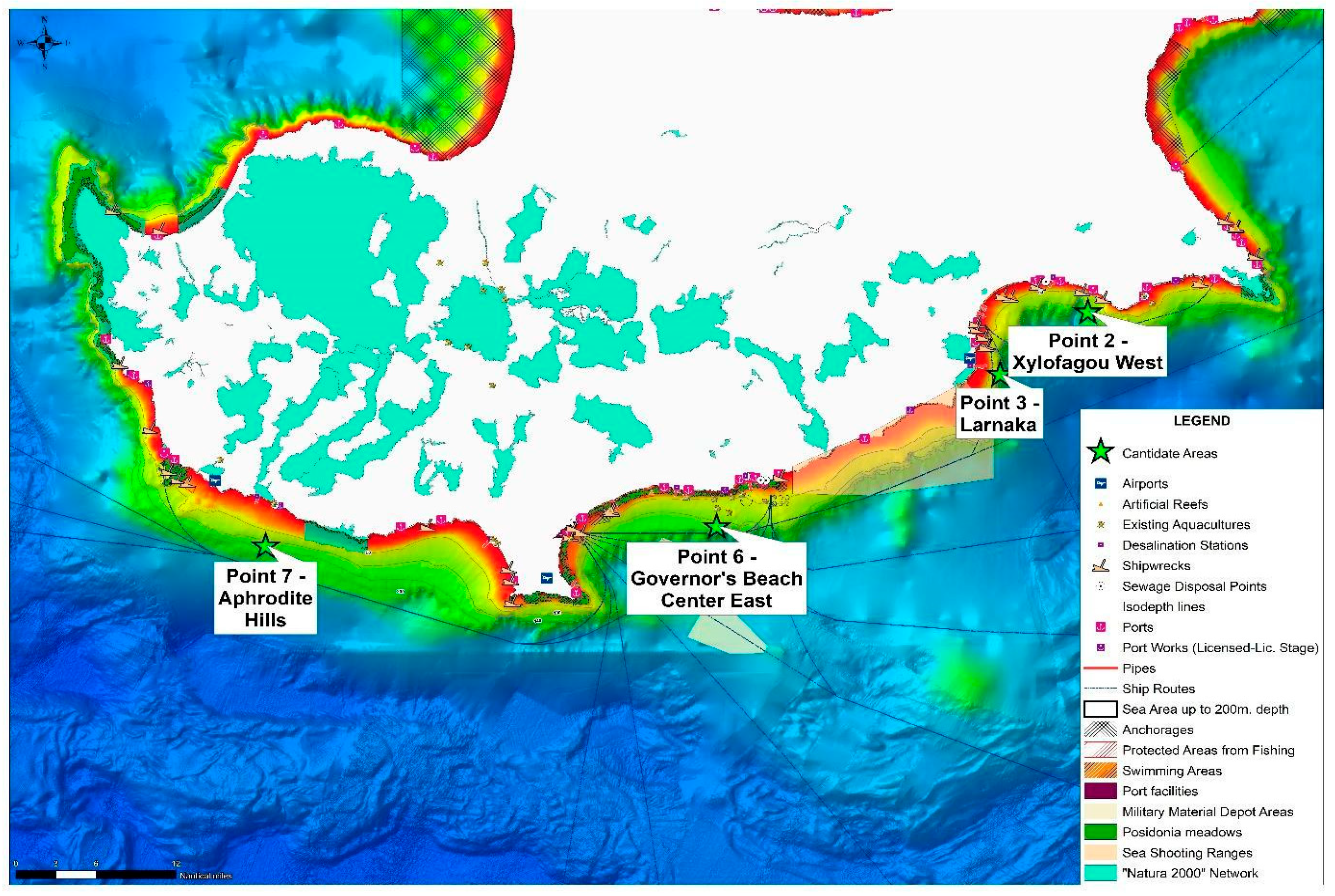
22]. However, the spatial scope of the present study is limited to the marine areas currently administered by the Republic of Cyprus. Due to the political division of the island following the events of 1974, the Republic of Cyprus does not exercise effective control over the entirety of the island’s coastline. Consequently, the GIS-MSP analysis focuses on the southern and southeastern marine regions falling within the practical jurisdictional scope of the study (Figure 3, Panel A). As a result, the spatial analysis focused on the marine waters south and southeast of Cyprus, where existing aquaculture activity, available infrastructure, bathymetric conditions, and offshore operational requirements create favourable conditions for offshore development. Four candidate offshore areas were initially identified for further investigation and assessment: Xylofagou West, Larnaka (Faros area), Governor’s Beach, and Avdimou/Aphrodite Hills (see
Figure 1) [
22].
The study area is also characterised by significant spatial complexity due to the coexistence of multiple marine uses and environmentally sensitive zones. Maritime transport routes, tourism development areas, fisheries activities, marine protected areas, Natura 2000 sites, military zones, underwater infrastructure, and coastal urbanization create substantial spatial constraints for offshore aquaculture planning (see
Table 1) [
16,
22]. Consequently, the identification of suitable offshore aquaculture development zones required the integration of environmental, operational, regulatory, and socio-economic criteria within a comprehensive GIS-MSP framework.
The offshore regions examined in this study were selected to support the long-term sustainable expansion of Cyprus aquaculture while minimizing environmental impacts and reducing spatial conflicts with other marine users. The selected areas also provide an appropriate case study for the development of transferable GIS-based offshore aquaculture planning methodologies applicable to other Mediterranean coastal regions characterized by similar environmental and spatial planning challenges.
The candidate offshore aquaculture areas investigated in this study were not selected solely on theoretical spatial suitability criteria. Their identification reflects the current status and future strategic direction of the Cyprus aquaculture sector, incorporating the outcomes of the OS AQUA Marine Spatial Planning process, consultations with the Department of Fisheries and Marine Research (DFMR), stakeholder feedback, and consistency with the national Maritime Spatial Planning framework. Consequently, the proposed study areas represent realistic development scenarios that consider existing aquaculture practices, environmental protection requirements, competing maritime activities, and long-term national planning priorities for the sustainable expansion of offshore aquaculture in Cyprus.
2.2. GIS Database and Spatial Data Sources
The GIS-based Marine Spatial Planning (MSP) framework developed in this study was supported by the design and implementation of an integrated geospatial database specifically developed for offshore aquaculture spatial planning in Cyprus. The database was established to support the collection, management, analysis, and visualization of marine spatial information required for the identification of suitable Allocated Zones for Aquaculture (AZAs) and Aquaculture Management Areas (AMAs). The GIS environment constituted a core component of the OS AQUA MSP decision-support framework [
22].
The OS AQUA GIS was developed using an open-source architecture. QGIS software, version 3.36 was selected as the main platform for spatial data import, processing, thematic mapping, and spatial analysis, while PostgreSQL was adopted as the database management system for the storage and management of hydrographic, environmental, infrastructural, and operational datasets. The GIS environment was designed to support both local deployment and future expansion towards web-based geospatial applications and decision-support services related to Cyprus marine spatial planning [
22].
The geospatial database integrated multiple thematic spatial datasets originating from governmental departments, project partners, and publicly available marine information sources. The principal environmental datasets included bathymetry, Natura 2000 protected areas, Posidonia oceanica meadows, protected fishing areas, artificial reefs, shipwrecks, sewage disposal points, desalination stations, and marine environmental protection zones. These datasets were used to represent environmental sensitivity, habitat protection requirements, and ecosystem-based planning considerations relevant to offshore aquaculture site selection [
22].
Operational and spatial-planning datasets incorporated uncontrolled maritime areas, swimming areas, commercial ports, anchorages, maritime navigation routes, disposal pipelines, military activity zones, airport buffer zones, existing aquaculture facilities, and other marine uses potentially generating spatial conflicts with offshore aquaculture development. These datasets were integrated into the GIS framework to support exclusion mapping, proximity assessment, and operational suitability analysis [
22]. The principal spatial datasets incorporated into the GIS-MSP database and their analytical role within the offshore aquaculture suitability assessment are summarized in
Table 2.
Spatial processing and analysis involved the application of vector- and raster-based GIS operations, including spatial overlays, buffering procedures, clipping, distance calculations, and thematic layer integration. The resulting database provided the analytical foundation for the three-phase MSP methodology applied in this study, comprising the application of exclusion criteria, weather and proximity assessment, and the final selection of candidate offshore aquaculture zones following stakeholder and policy evaluation procedures [
22].
Environmental and Oceanographic Datasets
The environmental and oceanographic datasets used in this study were compiled from national authorities, the Oceanography Centre of the University of Cyprus (OC-UCY), the Department of Fisheries and Marine Research (DFMR), the Department of Lands and Surveys (DLS), the Department of Environment (DoE), and other official geospatial data providers participating in the OS AQUA project. These datasets included bathymetry, marine protected areas, Posidonia oceanica meadows, ports, navigation routes, anchorages, existing aquaculture facilities, artificial reefs, desalination plants, sewage outfalls, meteorological conditions, wave climate, currents, and other environmental and maritime-use information.
The GIS analysis was based on representative long-term environmental datasets appropriate for strategic Marine Spatial Planning (MSP) rather than short-term field observations. Seasonal and interannual oceanographic variability, including wave climate, prevailing currents, seawater temperature, water quality, and other environmental parameters, was evaluated during the OS AQUA project through dedicated oceanographic and environmental assessments. These analyses were used to support the identification, evaluation, and final selection of candidate offshore aquaculture zones while recognizing that detailed site-specific investigations remain necessary prior to commercial development. Detailed analyses of seasonal wave conditions, prevailing currents, seawater temperature, salinity, and water quality for the candidate offshore aquaculture areas were performed within the OS AQUA project [
22] and are comprehensively documented in Deliverables D13 and D14. These analyses provided the scientific basis for the environmental suitability assessment adopted in the present GIS-based Marine Spatial Planning framework. These analyses provided the scientific basis for the environmental suitability assessment adopted in the present GIS-based Marine Spatial Planning framework.
2.3. GIS-Based Marine Spatial Planning Methodology
A structured GIS-based Marine Spatial Planning (MSP) methodology was developed within the framework of the OS AQUA project to support the identification and evaluation of suitable offshore aquaculture development zones in Cyprus. The methodological framework adopted a multi-phase spatial analysis approach integrating environmental, operational, infrastructural, regulatory, and stakeholder-related criteria within a unified decision-support environment [
22].
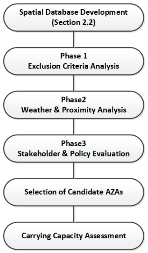
The methodology was implemented through a sequential three-phase analytical workflow designed to progressively reduce the pool of potentially suitable marine areas and refine the final selection of candidate Allocated Zones for Aquaculture (AZAs). The overall GIS-MSP methodological workflow adopted in this study is illustrated in
Figure 2. The framework combined GIS spatial analysis, exclusion mapping, weather and proximity assessment, and stakeholder-supported policy evaluation procedures [
22].
The criteria and threshold values adopted within the GIS-based Marine Spatial Planning framework were selected based on biological requirements for offshore aquaculture, published scientific literature, engineering and operational constraints, environmental protection objectives, maritime spatial uses, applicable regulatory requirements, and practical feasibility considerations. Together, these criteria and threshold values provide a transparent and scientifically justified basis for the sequential spatial screening process adopted in this study.
It should be noted that the present framework does not employ a weighted multi-criteria decision analysis (MCDA) or Analytic Hierarchy Process (AHP) approach. Instead, the methodology follows a sequential screening procedure in which candidate areas are progressively filtered through environmental exclusion criteria, operational suitability assessment, and stakeholder-policy evaluation stages. Consequently, no weighting factors were assigned to individual criteria and no sensitivity analysis of criterion weights was performed.
In the first phase, a spatial exclusion analysis was performed to eliminate marine areas considered unsuitable for offshore aquaculture development due to environmental protection requirements, operational limitations, maritime safety considerations, and regulatory restrictions. Environmental exclusion layers included Natura 2000 areas, Posidonia oceanica habitats, protected fishing zones, artificial reefs, and other environmentally sensitive areas. Additional exclusion criteria considered maritime infrastructure, navigation routes, airport restrictions, military zones, disposal pipelines, and incompatible marine uses [
22].
The second phase focused on operational suitability assessment through weather and proximity analysis. Key operational factors included offshore accessibility, distance from commercial ports and supporting infrastructure, prevailing meteorological and oceanographic conditions, wave and wind exposure, and operational feasibility considerations associated with offshore aquaculture deployment. The analysis aimed to identify marine areas capable of supporting technically viable and operationally sustainable aquaculture activities under open-sea conditions [
22].
In the third phase, the preliminary candidate zones resulting from GIS analysis were further evaluated through stakeholder consultation and policy-integration procedures. This stage incorporated feedback from governmental authorities, environmental organizations, aquaculture stakeholders, and marine planning actors in order to assess social acceptance, environmental compatibility, regulatory feasibility, and spatial interactions with other marine users. The final selection of candidate offshore aquaculture zones was therefore based not only on geospatial suitability but also on governance, environmental, and policy considerations consistent with Marine Spatial Planning principles [
22].
The resulting methodological framework provided the basis for the identification of candidate offshore aquaculture development areas and the subsequent carrying-capacity assessment presented in the following sections.
2.4. Phase 1—Application of Exclusion Criteria
The first phase of the GIS-based Marine Spatial Planning (MSP) methodology involved the application of spatial exclusion criteria to progressively eliminate marine areas considered unsuitable for offshore aquaculture development. The objective of this phase was to reduce the spatial search domain by identifying zones constrained by environmental protection requirements, maritime safety considerations, operational limitations, safety restrictions, and incompatible marine uses [
22].
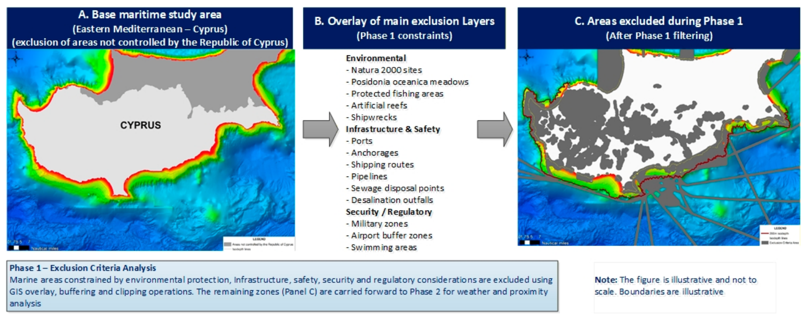
A multi-criteria spatial exclusion approach was implemented within the GIS environment using vector-based overlay analysis, spatial clipping, buffering procedures, and thematic layer integration. Each exclusion layer represented a constraint capable of restricting or preventing offshore aquaculture deployment. The cumulative overlay of all exclusion layers generated a progressively refined marine suitability mask used for the subsequent analytical phases of the methodology. The overall exclusion analysis workflow and the resulting spatial filtering process applied during Phase 1 are illustrated in
Figure 3.
Environmental exclusion criteria incorporated protected and environmentally sensitive marine areas including Natura 2000 sites, Posidonia oceanica meadows, protected fishing areas, artificial reefs, shipwreck locations, and other marine protection zones. These datasets were introduced to ensure compliance with ecosystem-based management principles and to minimize potential conflicts with biodiversity conservation objectives and environmentally vulnerable habitats [
22].
Infrastructure- and safety-related exclusion criteria included commercial ports, anchorages, maritime navigation routes, airport restriction zones, sewage disposal points, desalination discharge areas, and underwater pipeline infrastructure. Appropriate spatial buffers were applied where required to account for navigational safety, operational restrictions, and environmental protection requirements associated with existing marine infrastructure [
22]. The exclusion criteria incorporated into the Phase 1 GIS-MSP analysis are summarized in
Table 3.
Additional exclusion layers represented operational, regulatory, and security constraints, including military activity zones, uncontrolled marine areas, swimming areas, and incompatible maritime activities that could generate operational conflicts with offshore aquaculture development. These criteria were integrated into the GIS framework to ensure that the resulting candidate areas satisfied both technical feasibility and marine governance requirements [
22].
It should be emphasized that the qualitative ratings (e.g., “High”, “Moderate-High”, “Good”, and “Suitable”) do not represent subjective expert judgement or weighted scores. Instead, they reflect the cumulative outcome of the sequential GIS-based screening process, whereby each candidate area was progressively evaluated against the predefined environmental, engineering, regulatory, operational, and socio-economic criteria presented in
Table 3 and
Table 4. Consequently, the final qualitative classification expresses the overall level of suitability achieved after all exclusion, operational suitability, and stakeholder-policy evaluation stages had been systematically completed, rather than the result of an independent scoring or weighting procedure.
Table 5 summarises the principal exclusion criteria and the corresponding buffer distances applied during Phase 1 of the GIS-based Marine Spatial Planning analysis [
23]. These distances were adopted from the OS AQUA Marine Spatial Planning methodology and implemented consistently within the GIS spatial screening process to minimise environmental conflicts, operational constraints, navigational risks, and regulatory incompatibilities. The application of these standardized exclusion buffers ensured a transparent, reproducible, and consistent spatial screening procedure throughout the GIS-MSP analysis.
The sequential application and integration of the exclusion criteria resulted in the identification of a reduced number of preliminary offshore candidate areas suitable for further assessment. These remaining marine zones formed the input dataset for the second phase of the methodology involving weather conditions, accessibility, and proximity analysis.
2.5. Phase 2—Weather and Proximity Analysis
The second phase of the GIS-MSP framework focused on the operational suitability assessment of the preliminary marine zones identified during the exclusion analysis phase. While Phase 1 eliminated environmentally, technically, and regulatorily incompatible areas, Phase 2 aimed to evaluate the operational viability of the remaining candidate zones under offshore conditions. The analysis incorporated weather-related criteria and proximity-based operational indicators considered critical for offshore aquaculture deployment, including wave exposure, prevailing wind conditions, accessibility, distance from supporting infrastructure, and logistical feasibility [
22].
The assessment sought to identify marine areas capable of supporting technically feasible, operationally sustainable, and economically practical offshore aquaculture activities within the environmental and geographical context of Cyprus. Given the exposure and complexity associated with open-sea aquaculture systems, weather conditions and operational accessibility constitute important determinants of offshore performance, infrastructure resilience, maintenance requirements, and production continuity.
The Phase 2 assessment criteria are described in the following subsections, while the corresponding comparative operational evaluation framework is summarized in
Table 6,
Table 7,
Table 8 and
Table 9.
2.5.1. Weather-Condition Criteria
Weather conditions constitute a critical component of offshore aquaculture planning due to their direct influence on operational feasibility, structural performance, accessibility, and long-term production sustainability. Within the second phase of the GIS-MSP framework, weather-related criteria were analysed to assess the suitability of the preliminary candidate zones identified following the exclusion analysis phase. The assessment focused primarily on wave exposure and prevailing wind conditions, which are considered major operational determinants for offshore aquaculture systems operating in exposed marine environments [
22].
Wave conditions were evaluated to assess the expected degree of offshore exposure affecting aquaculture infrastructure, mooring systems, cage stability, maintenance operations, and vessel accessibility. Increased wave intensity may significantly influence installation requirements, operational costs, maintenance scheduling, and overall system resilience in offshore aquaculture applications. Consequently, wave exposure constitutes a key suitability criterion in offshore site selection and marine spatial planning studies [
15].
Prevailing wind conditions were also incorporated into the analysis due to their influence on sea state, operational accessibility, navigation conditions, maintenance windows, and offshore working conditions. Wind exposure may directly affect feeding operations, monitoring activities, servicing interventions, and personnel transfer procedures associated with offshore aquaculture installations [
14,
15]. The principal weather and operational indicators applied during the Phase 2 analysis are summarized in
Table 6.
Table 6.
Weather and operational criteria applied during Phase 2 analysis.
Table 6.
Weather and operational criteria applied during Phase 2 analysis.
| Criterion | Indicator | Analytical Role |
|---|
| Wind conditions | Mean/maximum seasonal wind speed | Offshore operability and accessibility |
| Wave conditions | Significant wave height (SWH) | Structural feasibility and exposure assessment |
| Distance to ports | Proximity to harbour facilities (km) | Logistics and operational feasibility |
| Infrastructure accessibility | Access to supporting facilities | Operational support and servicing capability |
| Seasonal variability | Seasonal weather patterns | Operational continuity and planning |
In addition to their engineering and operational implications, weather conditions introduce important uncertainty factors affecting offshore production continuity and operational planning. Environmental variability, accessibility constraints, and weather-dependent maintenance requirements can influence production scheduling, logistics management, and decision-support needs within offshore aquaculture systems. These considerations highlight the importance of integrating weather-related operational criteria into marine spatial planning and offshore aquaculture assessment frameworks [
25].
Weather-condition analysis within the OS AQUA framework was conducted using marine and meteorological information relevant to the Cyprus offshore environment in order to comparatively evaluate the operational exposure characteristics of the candidate aquaculture zones. The resulting assessment provided one of the key inputs for the subsequent comparative evaluation and shortlisting of suitable offshore development areas. A summary of the principal weather exposure indicators used for the comparative evaluation of the candidate offshore locations is presented in
Table 7.
Table 7.
Summary of weather exposure indicators for the candidate offshore aquaculture locations (Data from [
22]).
Table 7.
Summary of weather exposure indicators for the candidate offshore aquaculture locations (Data from [
22]).
| Candidate Area | Mean SWH (m) | Maximum SWH (m) | Mean Wind Speed (m/s) | Relative Weather Exposure |
|---|
| Xylofagou West (Point 2) | 0.48 | 5.05 | 3.85 | Moderate |
| Larnaka (Faros area) (Point 3) | 0.41 | 4.75 | 3.79 | Moderate |
| Governor’s Beach (Point 6) | 0.49 | 5.16 | 4.44 | Low-Moderate |
| Aphrodite Hills/Avdimou (Point 7) | 0.75 | 6.66 | 4.93 | High |
2.5.2. Proximity Criteria
In addition to weather-related considerations, the operational suitability assessment incorporated proximity-based criteria associated with infrastructure accessibility, logistics performance, and offshore operational support. The geographical relationship between candidate offshore locations and supporting coastal infrastructure constitutes an important determinant of offshore aquaculture feasibility, affecting transportation requirements, maintenance operations, emergency response capability, and overall production efficiency [
22].
Distance from port infrastructure was considered a key operational criterion within the Phase 2 assessment. Commercial ports, fishing shelters, marinas, and coastal support facilities provide essential operational services for offshore aquaculture activities, including transportation of feed and personnel, equipment maintenance, harvesting operations, monitoring activities, and emergency interventions. Increased offshore distance from supporting infrastructure may significantly influence transportation costs, travel time, fuel consumption, maintenance logistics, and operational complexity [
22].
Infrastructure accessibility was further evaluated through the consideration of proximity to supporting facilities and the practical feasibility of routine offshore operations. Accessibility constraints become increasingly important under exposed offshore conditions, where weather dependency, vessel availability, and servicing requirements may strongly influence operational continuity and system performance. Consequently, accessibility assessment forms an important component of offshore aquaculture planning and marine spatial suitability evaluation [
15]. The main proximity criteria considered within the GIS-MSP operational suitability assessment, together with their analytical role in offshore aquaculture planning, are summarized in
Table 8.
Table 8.
Proximity criteria applied during Phase 2 assessment.
Table 8.
Proximity criteria applied during Phase 2 assessment.
| Criterion | Indicator | Operational Role |
|---|
| Distance to ports | km | Logistics feasibility |
| Access to support infrastructure | Proximity index | Operational support |
| Accessibility | Travel distance/time | Offshore servicing capability |
| Emergency access | Response feasibility | Operational resilience |
The integration of proximity-based criteria within the GIS-MSP framework enabled the comparative evaluation of the candidate offshore locations with respect to logistical feasibility, operational support capability, and long-term offshore manageability. Combined with weather-condition analysis, the proximity assessment contributed to the identification of marine areas capable of supporting technically feasible and operationally sustainable offshore aquaculture development.
2.5.3. Identification of Candidate Areas
The combined evaluation of weather-related conditions and proximity-based operational criteria enabled the comparative assessment of the preliminary offshore locations identified during the exclusion analysis phase. The integration of offshore exposure indicators, infrastructure accessibility, logistical feasibility, and operational support requirements provided a broader understanding of the practical suitability of candidate marine areas for offshore aquaculture deployment.
Candidate locations were comparatively assessed with respect to wave exposure, prevailing wind conditions, proximity to supporting port infrastructure, accessibility characteristics, and overall operational manageability under offshore conditions. The evaluation aimed to identify marine areas capable of simultaneously satisfying environmental, technical, logistical, and operational suitability requirements within the broader GIS-MSP framework [
22].
The assessment highlighted differences among the candidate offshore locations in terms of weather exposure profiles, infrastructure accessibility, and operational support capability. A comparative summary of the Phase 2 operational assessment results for the investigated candidate locations is presented in
Table 9. Offshore locations characterized by lower environmental exposure, adequate accessibility, and favourable logistical conditions demonstrated increased suitability for sustainable offshore aquaculture development. Conversely, locations presenting elevated weather exposure or reduced operational accessibility required additional consideration regarding infrastructure resilience, servicing requirements, and operational planning.
Table 9.
Comparative operational assessment of candidate offshore aquaculture locations.
Table 9.
Comparative operational assessment of candidate offshore aquaculture locations.
| Candidate Area | Weather Exposure | Port Accessibility | Operational Support | Overall Phase 2 Assessment |
|---|
| Xylofagou West (Point 2) | Moderate | Good | Good | Suitable |
| Larnaka (Faros area) (Point 3) | Moderate | Very Good | Very Good | Suitable |
| Governor’s Beach (Point 6) | Low-Moderate | Good | Good | Suitable |
| Aphrodite Hills/Avdimou (Point 7) | High | Moderate | Moderate | Conditionally Suitable |
The integrated weather and proximity assessment formed an important intermediate decision-support stage within the Phase 2 methodology, contributing to the progressive refinement of the candidate offshore areas before their subsequent evaluation through stakeholder consultation, governance considerations, and policy integration procedures applied during Phase 3 [
22].
2.6. Phase 3—Stakeholder and Policy Evaluation
The third phase of the GIS-MSP methodology focused on the refinement and final evaluation of the candidate offshore aquaculture areas through stakeholder consultation, governance considerations, and policy integration procedures. While the previous analytical phases concentrated primarily on environmental suitability, operational feasibility, and spatial compatibility assessment, Phase 3 aimed to incorporate institutional, regulatory, social, and policy dimensions relevant to sustainable offshore aquaculture planning in Cyprus.
The evaluation process considered the perspectives of governmental authorities, marine planning actors, aquaculture stakeholders, environmental organizations, and sectoral experts in order to assess the practical feasibility and long-term acceptability of the proposed offshore development zones. Particular emphasis was placed on environmental compatibility, regulatory compliance, stakeholder acceptance, and the interaction of candidate aquaculture areas with existing marine uses and national marine planning priorities [
22].
The integration of stakeholder- and policy-related criteria constituted a critical component of the final decision-support framework, contributing to the progressive refinement and final selection of candidate offshore aquaculture zones within the broader Marine Spatial Planning context.
2.6.1. Stakeholder Consultation and Policy Integration
The stakeholder and policy evaluation phase was implemented to complement the GIS-based spatial and operational analyses through the incorporation of institutional, governance, environmental, and socio-economic considerations relevant to offshore aquaculture development in Cyprus. Recognising that marine spatial planning extends beyond purely technical and environmental suitability assessment, the methodology integrated stakeholder perspectives and policy-related criteria into the final decision-support framework [
22].
The evaluation process involved consideration of inputs originating from governmental authorities, marine management bodies, environmental actors, aquaculture stakeholders, and sectoral experts associated with offshore aquaculture planning and marine governance. Particular attention was given to the role of the Department of Fisheries and Marine Research (DFMR), regulatory authorities, and marine planning stakeholders responsible for aquaculture licensing, environmental protection, marine resource management, and coastal development policies [
17,
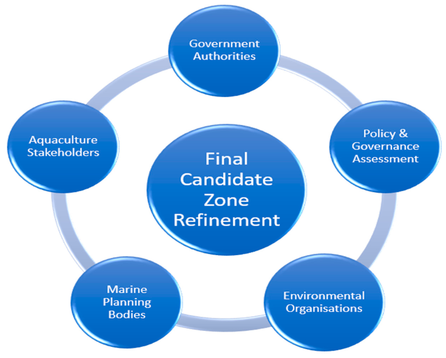
22]. The stakeholder consultation and policy integration framework adopted during Phase 3, including the principal governance actors and evaluation dimensions considered in the assessment process, is presented in
Figure 4.
Stakeholder consultation and policy evaluation focused on assessing the compatibility of the candidate offshore areas with existing regulatory requirements, environmental protection objectives, marine governance priorities, and national aquaculture development strategies. The assessment further considered potential interactions between offshore aquaculture development and competing marine activities, including tourism, maritime transport, fisheries, marine conservation, coastal infrastructure, and recreational uses [
22].
Environmental compatibility and stakeholder acceptance constituted important dimensions of the evaluation process. The proposed offshore candidate areas were assessed with respect to their potential environmental implications, social acceptability, governance feasibility, and alignment with sustainable blue growth objectives and ecosystem-based management principles. These considerations contributed to the broader evaluation of long-term offshore aquaculture sustainability within the Cyprus marine planning context [
22].
The integration of stakeholder consultation and policy-related criteria provided an important governance layer within the GIS-MSP framework, supporting a more holistic and policy-informed assessment of offshore aquaculture suitability. This process contributed to the refinement and final evaluation of the candidate offshore zones prior to their final selection and carrying-capacity assessment.
The stakeholder and policy evaluation stage was based on stakeholder consultation activities and expert discussions undertaken within the OS AQUA project, including interactions with representatives from the Department of Fisheries and Marine Research (DFMR), aquaculture operators, marine planning experts, environmental stakeholders, and project partners. The purpose of this stage was not to perform a formal quantitative stakeholder assessment, but rather to incorporate governance, regulatory, environmental, and operational considerations into the final refinement of the candidate offshore zones.
2.6.2. Final Selection of Candidate Offshore Aquaculture Zones
The final selection of candidate offshore aquaculture zones resulted from the integration of the spatial, operational, governance, and policy evaluation stages implemented throughout the GIS-MSP framework. Following the progressive elimination of unsuitable marine areas through exclusion analysis and the comparative assessment of operational suitability through weather and proximity evaluation, the remaining candidate locations were further refined using stakeholder consultation and policy integration procedures [
22].
The final evaluation considered the capacity of the candidate areas to simultaneously satisfy environmental protection requirements, offshore operational feasibility, infrastructure accessibility, regulatory compatibility, and stakeholder acceptability. Particular attention was given to the interaction of candidate aquaculture zones with existing marine uses, national marine planning priorities, environmental governance requirements, and long-term sustainable aquaculture development objectives in Cyprus [
22].
Based on the integrated assessment process, four offshore candidate areas were retained for further planning consideration and carrying-capacity assessment: Xylofagou West, Larnaka (Faros area), Governor’s Beach, and Aphrodite Hills/Avdimou. These locations demonstrated comparatively favourable performance across the multiple criteria incorporated within the GIS-MSP framework, including environmental compatibility, offshore operational suitability, accessibility, logistical feasibility, and governance considerations [
22]. A comparative summary of the final integrated evaluation results for the selected offshore candidate zones is presented in
Table 10.
Although differences were observed among the candidate locations with respect to weather exposure, accessibility characteristics, and operational complexity, the selected areas collectively represented the most balanced compromise between environmental sustainability, offshore functionality, spatial compatibility, and policy feasibility within the Cyprus marine planning context. Locations characterised by increased exposure or operational constraints remained potentially viable but may require enhanced infrastructure resilience, adaptive operational planning, and additional management considerations for future offshore deployment.
The final selection of candidate offshore aquaculture zones provided the spatial planning basis for the subsequent carrying-capacity assessment phase, which aimed to evaluate the production potential and environmental sustainability implications associated with the proposed offshore development framework.
It should be emphasized that the GIS-based Marine Spatial Planning framework developed in this study is intended as a strategic decision-support tool for the identification and prioritization of potentially suitable offshore aquaculture areas. The proposed methodology does not replace the detailed site-specific investigations required prior to commercial development. Future implementation of individual offshore aquaculture farms should be preceded by detailed hydrographic and geotechnical surveys, hydrodynamic modelling, environmental impact assessments, engineering design studies, licensing procedures, and operational feasibility analyses to confirm the suitability of each selected location.
Although no weighted scoring system was applied, the final ranking reflected the cumulative performance of each candidate area across the three assessment phases. Larnaka and Xylofagou West demonstrated the most favourable balance between environmental compatibility, accessibility, proximity to supporting infrastructure, and stakeholder acceptance. Governor’s Beach presented slightly higher operational constraints, while Aphrodite Hills/Avdimou was associated with increased weather exposure and accessibility challenges despite its favourable environmental characteristics.
The qualitative ratings presented in
Section 3 (e.g., “High”, “Moderate-High”, “Good”, and “Suitable”) do not represent subjective judgement or the outcome of a formal weighted scoring system. Instead, they represent qualitative interpretations of the cumulative performance of each candidate area across the three sequential assessment phases of the GIS-based Marine Spatial Planning framework, namely: (i) exclusion criteria analysis, (ii) weather and proximity assessment, and (iii) stakeholder and policy evaluation. The qualitative classifications were used to facilitate interpretation and comparison of the candidate areas while maintaining consistency with the decision-support nature of the proposed planning framework.
2.7. Carrying Capacity Estimation
Following the identification, operational assessment, and policy evaluation of the candidate offshore aquaculture zones, the final methodological stage focused on carrying capacity estimation. The incorporation of carrying capacity considerations within the GIS-MSP framework aimed to evaluate the potential production capability of the selected offshore areas while maintaining environmental sustainability and compatibility with the ecological characteristics of the receiving marine environment.
The carrying capacity assessment was performed using a theoretical framework adapted to Mediterranean marine aquaculture systems and informed by established approaches reported in the literature and relevant aquaculture planning guidelines [
26,
27,
28]. Particular attention was given to offshore environmental conditions, site exposure characteristics, and production assumptions relevant to the Cyprus open sea aquaculture context.
The carrying capacity evaluation was undertaken through two complementary analytical steps. First, the theoretical background and conceptual basis of carrying capacity assessment in marine aquaculture are introduced. Subsequently, the methodology is applied to the selected Cyprus offshore candidate areas to estimate indicative production capacity levels under the assumptions adopted within the OS AQUA framework.
Within the OS AQUA project, carrying-capacity estimation was based on the approach presented in Deliverable D13 [
22], which adapted the methodology developed by Karakassis and co-workers to the offshore Cyprus context [
26]. The calculation incorporated coefficients reflecting distance from the coast, water depth, and site exposure/flow conditions. For the potential offshore AZAs, the assumptions adopted were distance from the coast greater than 1000 m (fA = 2), water depth between 100 and 200 m (fB = 2), and highly exposed offshore conditions with strong water exchange (fK = 2.5). Under these assumptions, the theoretical carrying capacity for a maximum aquaculture park area of 100,000 m
2 was estimated at approximately 8700 tonnes [
22]. However, for the purposes of the OS AQUA planning scenarios, a more precautionary production level of 5000 tonnes per AZA/AMA was adopted in order to provide an additional environmental safety margin and support sustainable offshore development.
The resulting carrying-capacity estimates are intended to support strategic Marine Spatial Planning and offshore aquaculture zoning decisions at the regional scale. They should not be interpreted as operational carrying capacities for individual offshore aquaculture farms, which require site-specific hydrodynamic modelling, environmental monitoring, and detailed engineering assessment prior to commercial implementation.
2.7.1. Theoretical Framework
Carrying capacity represents one of the central concepts in sustainable aquaculture planning and marine resource management. In marine aquaculture systems, carrying capacity generally refers to the maximum level of production that can be supported by a receiving marine ecosystem without causing unacceptable environmental deterioration, ecological imbalance, or conflicts with other marine users [
26]. The concept is closely linked to ecosystem resilience, assimilative capacity, ecological thresholds, and the sustainable use of marine resources.
The carrying capacity concept has been described through different analytical dimensions depending on the management perspective adopted. These include physical carrying capacity, which relates to environmental conditions and space availability; production carrying capacity, associated with maximizing production performance; ecological carrying capacity, which focuses on minimizing environmental impacts; and social carrying capacity, associated with stakeholder acceptance and conflict reduction among marine users [
29]. Within Marine Spatial Planning (MSP) and offshore aquaculture development, environmental and ecological carrying capacity is typically considered particularly important.
The carrying capacity methodology adopted within the OS AQUA framework was informed by Mediterranean aquaculture planning approaches and by the work of Karakassis and co-workers regarding production adaptation to the environmental characteristics of receiving marine ecosystems [
26]. According to this approach, aquaculture production potential should be adapted to site-specific environmental conditions, taking into account factors such as water depth, hydrodynamic regime, offshore exposure, and environmental sensitivity. The underlying rationale is that deeper, offshore, and more exposed environments may exhibit greater dilution and dispersion capacity and therefore may support higher production levels while maintaining environmental sustainability.
The integration of carrying capacity assessment into Marine Spatial Planning and Allocated Zones for Aquaculture (AZA) establishment is widely recognised within Mediterranean aquaculture governance frameworks [
27]. Carrying capacity estimation contributes to the evaluation of production potential, environmental compatibility, and long-term sustainability of proposed aquaculture development zones, supporting informed decision-making within broader ecosystem-based marine management approaches.
For the Cyprus offshore aquaculture context, carrying capacity assessment constitutes an important methodological component, given that the selected candidate areas are located in relatively deep and exposed offshore environments characterized by enhanced water circulation, oligotrophic marine conditions, and reduced interaction with nearshore sensitive ecosystems. Incorporating carrying capacity estimation within the GIS-MSP framework therefore provided an additional sustainability layer supporting the final evaluation of offshore aquaculture development potential.
2.7.2. Carrying Capacity Estimation for Cyprus Offshore Sites
The carrying capacity estimation for the Cyprus offshore candidate areas was performed within the framework of the OS AQUA project using a theoretical approach adapted from Mediterranean aquaculture planning methodologies and the work of Karakassis and co-workers [
22,
26]. The assessment aimed to estimate indicative production levels compatible with the environmental characteristics of the selected offshore environments while maintaining a precautionary sustainability perspective.
The estimation framework considered the environmental characteristics of the selected offshore candidate areas, including water depth, offshore exposure, hydrodynamic conditions, and the increased dispersion potential associated with open-sea environments. These offshore characteristics are generally recognised as factors that may contribute to increased environmental assimilative capacity compared with conventional nearshore aquaculture systems [
26,
27].
Within the OS AQUA assessment framework, a maximum aquaculture park area of 100,000 m
2 was considered for each Open Sea Allocated Zone for Aquaculture (OS AZA). Based on the carrying capacity methodology adopted in the project, the theoretical carrying capacity corresponding to this spatial configuration was estimated at approximately 8700 tonnes of production per offshore AZA [
22].
Nevertheless, the production scenarios analysed within the project adopted a more conservative operational assumption, limiting the investigated production level to a maximum of 5000 tonnes per AZA/AMA. This precautionary assumption was introduced in order to maintain an additional environmental safety margin and support the long-term sustainability objectives of offshore aquaculture development in Cyprus [
22]. It should be emphasized that the carrying-capacity assessment presented in this study represents a strategic planning estimate intended to support Marine Spatial Planning and preliminary offshore aquaculture zoning rather than a definitive production limit for commercial farm development. Prior to commercial implementation, detailed site-specific hydrodynamic modelling, benthic impact assessments, environmental monitoring, and adaptive management strategies would be required to determine the environmentally sustainable production capacity of each individual offshore aquaculture site.
The selected candidate offshore areas—Xylofagou West, Larnaka (Faros area), Governor’s Beach, and Aphrodite Hills/Avdimou—were subsequently evaluated under the adopted production assumptions in order to examine their compatibility with sustainable offshore aquaculture deployment. The incorporation of carrying capacity estimation within the GIS-MSP framework provided an important quantitative sustainability component complementing the spatial, operational, governance, and policy analyses undertaken in the previous methodological stages.
The carrying capacity assessment therefore contributed to the broader evaluation of offshore aquaculture feasibility in Cyprus by supporting the alignment of production ambitions with environmental sustainability considerations, ecosystem protection objectives, and long-term Marine Spatial Planning requirements.
3. Results
The GIS-based Marine Spatial Planning (MSP) framework developed in this study produced a progressive refinement of suitable offshore aquaculture development areas through the sequential application of exclusion criteria, operational suitability assessment, stakeholder and policy evaluation, and carrying-capacity estimation. The resulting analytical process enabled the identification, evaluation, and comparative assessment of candidate offshore aquaculture zones within the Cyprus marine environment.
This section presents the principal outcomes of the GIS-MSP analysis. The results are organized according to the major methodological stages of the framework, including spatial exclusion analysis, weather and proximity assessment, final offshore zone selection, and carrying-capacity evaluation. The section concludes with the presentation of the resulting spatial planning framework and its broader applicability to offshore aquaculture planning in the Mediterranean region.
3.1. Results of Spatial Exclusion Analysis
The application of the Phase 1 exclusion analysis resulted in a substantial reduction in the initially available marine search domain considered for offshore aquaculture development in Cyprus. The sequential integration of environmental, infrastructural, regulatory, operational, and safety-related exclusion layers progressively eliminated marine areas considered incompatible with sustainable offshore aquaculture deployment.
Environmental protection criteria constituted one of the dominant spatial filtering components within the GIS-MSP framework. Natura 2000 protected areas,
Posidonia oceanica meadows, protected fishing zones, artificial reefs, and other environmentally sensitive marine habitats generated significant spatial restrictions, particularly within nearshore and ecologically vulnerable coastal regions. The incorporation of these exclusion layers ensured consistency with ecosystem-based management principles and environmental protection objectives associated with marine spatial planning [
22].
Additional reductions in suitable marine space resulted from the application of infrastructural, navigational, and operational exclusion criteria. Maritime transport routes, commercial ports, anchorages, airport restriction zones, military activity areas, disposal pipelines, desalination-related infrastructure, and swimming zones generated important operational and regulatory constraints affecting offshore aquaculture suitability. Buffering procedures applied to these spatial features further reduced the number and extent of candidate marine areas available for subsequent assessment [
22].
The cumulative overlay of all exclusion criteria produced a progressively refined offshore suitability domain characterised by a smaller number of remaining marine areas demonstrating increased compatibility with offshore aquaculture requirements. The resulting exclusion process and the associated spatial filtering outcomes are illustrated in
Figure 3, while the principal exclusion criteria incorporated into the analysis are summarized in
Table 3. The progressive spatial filtering effect of the exclusion analysis applied during Phase 1 is illustrated in
Figure 3.
The exclusion analysis demonstrated the high degree of spatial complexity associated with offshore aquaculture planning in Cyprus, where environmental protection requirements, competing marine uses, tourism-related coastal pressures, maritime infrastructure, and regulatory constraints significantly influence marine space availability. Nevertheless, the remaining offshore areas identified through Phase 1 provided a suitable basis for the subsequent operational assessment involving weather-condition and proximity evaluation.
3.2. Results of Weather and Proximity Assessment
The Phase 2 operational suitability assessment revealed notable differences among the investigated offshore candidate locations with respect to weather exposure characteristics, accessibility conditions, and logistical feasibility. The combined analysis of marine environmental indicators and proximity-related criteria enabled a comparative evaluation of the operational suitability of the candidate offshore aquaculture zones. The comparative operational assessment results obtained from the weather-condition and proximity analyses are summarized in
Table 7,
Table 8 and
Table 9.
The weather-condition assessment indicated variability among the investigated offshore locations in terms of significant wave height, wind exposure, and overall offshore environmental intensity. The selected candidate areas generally exhibited environmental conditions compatible with offshore aquaculture deployment, although important differences were observed between sites characterised by relatively moderate offshore exposure and those associated with increased environmental forcing. A summary of the principal weather indicators derived from the assessment is presented in
Table 7.
Among the evaluated locations, Xylofagou West (Point 2) and Larnaka (Faros area, Point 3) demonstrated relatively favourable operational profiles characterised by moderate environmental exposure and comparatively lower mean wave and wind conditions. Governor’s Beach (Point 6) presented comparable operational characteristics, exhibiting moderate offshore exposure together with acceptable accessibility conditions. In contrast, Aphrodite Hills/Avdimou (Point 7) demonstrated comparatively higher environmental exposure levels, reflected in elevated significant wave height and wind indicators, suggesting increased operational complexity for offshore aquaculture deployment.
The proximity assessment further highlighted differences related to logistical feasibility, infrastructure accessibility, and offshore operational support capability. Candidate locations located in closer association with port infrastructure and supporting coastal facilities demonstrated advantages regarding transportation requirements, servicing logistics, maintenance operations, and operational manageability. The principal proximity criteria considered during the assessment are summarized in
Table 8, while the comparative operational evaluation results are presented in
Table 9.
The integrated weather and proximity assessment demonstrated that offshore aquaculture suitability in Cyprus cannot be determined solely by environmental compatibility or spatial availability considerations. Instead, operational feasibility is strongly influenced by the interaction between environmental exposure, accessibility conditions, infrastructure support, and logistical practicality. The Phase 2 evaluation therefore provided an important intermediate decision-support stage contributing to the refinement of candidate offshore aquaculture zones prior to stakeholder and policy evaluation.
3.3. Selected Offshore Aquaculture Zones
The integrated GIS-MSP assessment framework resulted in the identification of four offshore candidate zones demonstrating comparatively favourable conditions for potential open sea aquaculture development in Cyprus. Following the combined application of exclusion analysis, operational suitability assessment, stakeholder consultation, policy evaluation, and carrying-capacity considerations, the retained candidate areas comprised Xylofagou West, Larnaka (Faros area), Governor’s Beach, and Aphrodite Hills/Avdimou.
The selected offshore locations exhibited different environmental, operational, and governance characteristics while collectively representing the most suitable compromise between spatial compatibility, offshore functionality, environmental sustainability, and planning feasibility within the Cyprus marine environment. The geographical distribution of the selected offshore zones is illustrated in
Figure 1, while their comparative integrated assessment profile is summarized in
Table 10.
Xylofagou West emerged as a promising offshore candidate area characterised by moderate environmental exposure, acceptable operational accessibility, and favourable compatibility with the applied spatial planning constraints. The location demonstrated balanced performance across environmental, operational, and logistical criteria, supporting its inclusion within the final candidate zone portfolio.
Larnaka (Faros area) exhibited similarly favourable suitability characteristics, benefiting from moderate offshore conditions and relatively advantageous accessibility and infrastructure support conditions. The area demonstrated strong compatibility with the GIS-MSP evaluation framework and represented one of the most operationally feasible candidate locations identified through the assessment process.
Governor’s Beach displayed comparatively favourable environmental and operational conditions, combining acceptable weather exposure with suitable accessibility characteristics and planning compatibility. The site demonstrated good overall performance within the integrated assessment despite certain operational constraints associated with offshore servicing considerations.
In contrast, Aphrodite Hills/Avdimou presented comparatively higher offshore exposure conditions relative to the other retained candidate locations. Nevertheless, despite increased operational complexity associated with wave and wind exposure, the site remained compatible with the broader environmental, spatial, and governance evaluation framework and was therefore retained as a viable offshore development candidate subject to appropriate operational planning and infrastructure adaptation measures.
Overall, the final selection results demonstrate the capacity of the GIS-MSP framework to support structured, multi-criteria offshore aquaculture planning under complex marine conditions characterised by competing uses, environmental constraints, and operational considerations. The identification of multiple candidate offshore zones further provides flexibility for future offshore aquaculture expansion strategies and adaptive marine spatial planning processes in Cyprus and similar Mediterranean environments.
3.4. Carrying Capacity Results
The carrying capacity assessment indicated that the selected offshore aquaculture candidate zones possess substantial production potential under the environmental and operational assumptions adopted within the OS AQUA framework. The analysis demonstrated that the offshore environmental characteristics of the investigated Cyprus sites—including increased water depth, offshore exposure, enhanced water circulation, and open-sea dispersion capacity—are compatible with comparatively elevated production capability relative to conventional nearshore aquaculture systems.
Based on the carrying capacity methodology adopted in the project, and assuming a maximum offshore aquaculture park area of 100,000 m
2 per Open Sea Allocated Zone for Aquaculture (OS AZA), the theoretical carrying capacity was estimated at approximately 8700 tonnes of production per offshore zone. The principal assumptions and quantitative parameters associated with the carrying capacity assessment are summarized in
Table 11. The principal quantitative assumptions and resulting production estimates obtained from the carrying capacity assessment are presented in
Table 11.
Although the theoretical assessment suggested the potential for higher production levels, the project adopted a more conservative operational scenario limiting the analysed production level to 5000 tonnes per AZA/AMA. This precautionary approach reflects the emphasis placed on environmental sustainability, ecosystem protection, and long-term offshore management within the GIS-MSP framework.
The carrying capacity results suggest that the investigated offshore candidate zones may support substantial aquaculture production while maintaining compatibility with environmental sustainability objectives and ecosystem-based planning principles. The adoption of conservative production assumptions further contributes to reducing uncertainty associated with offshore environmental response, operational variability, and long-term ecological resilience under open-sea aquaculture deployment conditions.
The carrying capacity assessment also demonstrates the importance of integrating production-potential evaluation within offshore Marine Spatial Planning methodologies. Beyond identifying spatially suitable marine areas, sustainable offshore aquaculture planning requires consideration of the interaction between environmental assimilative capacity, production ambitions, operational feasibility, and long-term ecosystem sustainability. Within the Cyprus offshore context, the carrying-capacity results therefore provide an important quantitative basis supporting future offshore aquaculture planning and development strategies.
3.5. Spatial Planning Maps and Final Zoning Framework
The integrated GIS-based Marine Spatial Planning (MSP) framework developed in this study resulted in a structured and transferable methodology for offshore aquaculture spatial planning under complex marine conditions. By combining exclusion analysis, operational suitability assessment, stakeholder and policy evaluation, and carrying-capacity estimation within a unified analytical workflow, the framework provided a comprehensive decision-support tool for the identification and evaluation of suitable offshore aquaculture development zones.
The proposed framework demonstrated the capability to integrate multiple environmental, operational, infrastructural, regulatory, and governance criteria within a single GIS-based planning environment. The methodology enabled the progressive refinement of candidate offshore locations while balancing environmental protection requirements, offshore operational feasibility, stakeholder considerations, and long-term sustainability objectives. The final GIS-MSP workflow and resulting zoning framework therefore provide a practical planning roadmap for offshore aquaculture development in Cyprus and comparable marine environments.
Although developed within the Cyprus context, the proposed methodology exhibits broader applicability to Mediterranean offshore aquaculture planning. Many Mediterranean coastal regions face similar spatial planning challenges associated with intensive coastal tourism, environmental sensitivity, competing marine uses, limited available marine space, regulatory complexity, and the growing need for offshore expansion [
7,
20,
28]. Consequently, the integrated GIS-MSP approach developed in this study may provide a transferable analytical framework capable of supporting offshore aquaculture zoning, AZA establishment, and sustainable marine planning initiatives in other Mediterranean regions.
The results further demonstrate that offshore aquaculture planning extends beyond purely environmental suitability assessment and requires the integration of operational, logistical, governance, and sustainability dimensions within broader marine planning processes. Offshore deployment introduces additional considerations related to infrastructure resilience, energy supply, operational continuity, production planning, economic feasibility, and optimisation of offshore production systems, which increasingly influence the viability of open-sea aquaculture development [
7,
9,
10,
14,
16,
26,
29].
From a policy perspective, the proposed framework supports evidence-based Marine Spatial Planning, ecosystem-based marine management, and sustainable blue growth strategies consistent with evolving Mediterranean and European marine governance priorities. The methodology may therefore contribute to future offshore aquaculture planning initiatives seeking to balance seafood production objectives, ecosystem protection requirements, and competing marine-use interactions under increasingly constrained coastal environments.
4. Discussion
The GIS-based Marine Spatial Planning (MSP) framework developed in this study enabled the systematic identification, evaluation, and refinement of offshore aquaculture development zones in Cyprus through the integration of spatial exclusion analysis, operational suitability assessment, stakeholder and policy evaluation, and carrying-capacity estimation. The results demonstrate the feasibility of combining environmental, operational, governance, and sustainability criteria within a unified GIS-MSP decision-support framework for offshore aquaculture planning.
This section discusses the broader implications of the findings in relation to offshore aquaculture development in Cyprus, environmental and operational considerations associated with offshore deployment, and wider Mediterranean Marine Spatial Planning challenges. Particular emphasis is placed on the transferability of the proposed framework, governance and policy implications, methodological limitations, and future research directions associated with emerging digital, monitoring, and adaptive planning approaches.
4.1. Implications for Offshore Aquaculture Development in Cyprus
The findings of this study have important implications for the future development of offshore aquaculture in Cyprus. The progressive spatial constraints affecting nearshore aquaculture development, combined with increasing environmental protection requirements, tourism pressures, competing marine uses, and Marine Spatial Planning (MSP) obligations, suggest that offshore expansion may represent an increasingly important strategic direction for the Cyprus aquaculture sector.
The GIS-MSP framework developed in this study demonstrates that offshore aquaculture development in Cyprus is technically feasible under carefully selected environmental, operational, and governance conditions. The identification of multiple candidate offshore development zones indicates that, despite the considerable spatial complexity characterising the Cyprus marine environment, opportunities exist for structured offshore aquaculture deployment supported by integrated spatial planning approaches.
The results further highlight the importance of adopting multi-criteria planning methodologies when evaluating offshore aquaculture potential. Environmental suitability alone does not guarantee offshore viability. Rather, sustainable offshore development requires simultaneous consideration of operational feasibility, infrastructure accessibility, stakeholder compatibility, regulatory coherence, and production sustainability. The integrated assessment approach proposed in this study therefore contributes to moving offshore aquaculture planning beyond conventional site-selection methodologies toward broader ecosystem-based and decision-support planning frameworks. The findings of the present study complement previous work undertaken within the OS-AQUA initiative concerning offshore aquaculture zoning, AZA development, and offshore structural planning for Cyprus aquaculture [
11,
30].
From a sectoral development perspective, the offshore candidate zones identified in this study may provide strategic opportunities for future production expansion, diversification of aquaculture spatial allocation, and improved long-term resilience of the Cyprus aquaculture industry. Offshore deployment may potentially contribute to reducing nearshore spatial conflicts, enhancing production flexibility, and supporting sustainable blue growth objectives within the national marine economy [
10,
11].
However, offshore transition also introduces important technical, operational, and investment challenges. Increased offshore exposure, servicing requirements, infrastructure complexity, energy demand, monitoring needs, and economic uncertainty may substantially influence the practical implementation and commercial viability of offshore aquaculture systems. Consequently, successful offshore development in Cyprus will likely require coordinated planning frameworks integrating spatial planning, environmental management, technological innovation, operational optimisation, and long-term policy support mechanisms [
10,
11].
Overall, the Cyprus case study illustrates both the opportunities and complexities associated with offshore aquaculture expansion in small Mediterranean coastal states characterised by limited marine space availability, intensive coastal activity, and increasing sustainability expectations. The proposed GIS-MSP framework therefore provides not only a national planning tool but also a broader analytical contribution relevant to offshore aquaculture planning in comparable regional contexts.
Although the GIS-MSP framework successfully identified offshore areas exhibiting favourable environmental and operational characteristics, spatial suitability alone does not guarantee economic viability. Offshore aquaculture development requires substantial capital investment in cages, mooring systems, service vessels, feeding technologies, monitoring equipment, and maintenance infrastructure. Operational costs are also influenced by distance from ports, weather-related accessibility constraints, insurance requirements, fuel consumption, labour availability, and logistics performance. Consequently, the identified candidate zones should be considered as spatially suitable development opportunities whose ultimate commercial viability will depend on detailed techno-economic assessments, financial analysis, and market conditions.
The economic competitiveness of offshore production based on European seabass (Dicentrarchus labrax) and gilthead seabream (Sparus aurata) requires particular consideration. Although both species are well established within Mediterranean markets and face strong regional competition, previous OS AQUA techno-economic analyses indicated that offshore production can remain economically attractive when supported by adequate production scale, efficient logistics, optimized farm design, and appropriate site selection. The GIS-MSP framework contributes to this objective by identifying locations that reduce operational constraints and support long-term production efficiency.
4.2. Environmental and Operational Considerations of Offshore Deployment
The results of this study further highlight the importance of environmental and operational considerations in determining the long-term feasibility of offshore aquaculture systems. While offshore environments may offer important advantages in terms of spatial availability, increased water circulation, dilution capacity, and reduced interaction with sensitive coastal ecosystems, they simultaneously introduce substantially greater technical and operational complexity compared with conventional nearshore aquaculture systems.
The weather and exposure assessment undertaken within the GIS-MSP framework demonstrated that offshore deployment suitability is strongly influenced by environmental forcing conditions, including significant wave height, wind intensity, accessibility constraints, and offshore operability requirements. Candidate locations exhibiting favourable environmental compatibility may nevertheless present important operational limitations related to servicing frequency, maintenance logistics, transportation requirements, and infrastructure resilience.
The transition toward offshore aquaculture systems therefore requires a broader systems-oriented planning perspective extending beyond spatial suitability analysis. Offshore deployment introduces additional requirements related to production planning, operational optimisation, infrastructure design, energy supply, remote monitoring, and economic performance management. Previous studies have highlighted the importance of decision-support methodologies, simulation approaches, and optimisation tools for improving the operational efficiency and economic sustainability of offshore aquaculture production systems [
9,
14,
15,
25,
31].
Energy management may represent a particularly important dimension for future offshore aquaculture deployment. The increasing technological complexity of offshore farming systems, together with growing requirements for automation, monitoring, feeding systems, data acquisition, and operational support infrastructure, may substantially increase offshore energy demand. Consequently, the integration of innovative offshore energy solutions, including renewable-energy configurations and emerging hydrogen-based approaches, may constitute an important research and development direction for future offshore aquaculture systems [
9,
14,
15].
In parallel, offshore operational sustainability increasingly depends on the integration of monitoring, digitalisation, and adaptive management approaches capable of supporting real-time decision-making under variable marine conditions. Environmental variability, offshore exposure, and production uncertainty reinforce the need for robust operational planning frameworks capable of balancing production efficiency, environmental performance, and economic viability.
The Cyprus case study therefore reinforces the argument that successful offshore aquaculture deployment should be approached not solely as a spatial planning exercise but as a multidisciplinary challenge requiring the coordinated integration of environmental science, marine engineering, operational research, energy systems, digital monitoring technologies, and long-term economic planning.
The identified candidate areas are broadly consistent with expert knowledge, existing offshore aquaculture development trends in Cyprus, and the strategic planning directions adopted within the OS AQUA project and DFMR consultations, providing an additional qualitative validation of the proposed framework.
4.3. Marine Spatial Planning Challenges in the Mediterranean
The findings of this study also contribute to the broader discussion concerning Marine Spatial Planning (MSP) challenges associated with offshore aquaculture development in the Mediterranean region. Mediterranean coastal systems are characterised by high spatial complexity resulting from the coexistence of intensive tourism activity, dense maritime traffic, fisheries, environmental protection areas, coastal infrastructure, urban development pressures, and increasing blue economy demands. Under such conditions, identifying suitable marine space for aquaculture development represents a particularly challenging planning task.
The Cyprus case study reflects many of the broader spatial planning pressures observed across Mediterranean coastal environments. The exclusion analysis performed within the GIS-MSP framework demonstrated the substantial influence of environmental protection requirements, competing marine uses, safety restrictions, and operational constraints on marine space availability, as documented within the OS-AQUA assessment process [
23]. Similar planning challenges have been reported across Mediterranean aquaculture systems, where limited coastal space availability and increasing regulatory complexity continue to influence aquaculture zoning and long-term sectoral development [
7,
28].
Within this context, Marine Spatial Planning and the establishment of Allocated Zones for Aquaculture (AZAs) have emerged as increasingly important governance instruments supporting more structured, transparent, and ecosystem-based aquaculture development pathways [
27]. The integration of GIS methodologies, multi-criteria assessment approaches, and stakeholder-informed planning processes can significantly improve the capacity of marine planners and policymakers to balance aquaculture development objectives with environmental protection requirements and competing marine interests.
The results of this study further suggest that offshore aquaculture expansion should not be interpreted simply as a geographical relocation of production activities from nearshore to offshore environments. Rather, offshore transition introduces new planning dimensions involving operational feasibility, governance coordination, carrying-capacity considerations, technological readiness, infrastructure requirements, and long-term sustainability management. Consequently, offshore Marine Spatial Planning frameworks may require increased methodological sophistication compared with conventional coastal aquaculture zoning approaches.
For Mediterranean countries characterised by fragmented coastal uses, environmental sensitivity, and growing blue economy ambitions, integrated GIS-MSP methodologies such as the framework developed in this study may provide valuable analytical tools for supporting adaptive, evidence-based, and sustainability-oriented offshore aquaculture planning. The Cyprus experience therefore offers insights that may be relevant to other Mediterranean coastal regions pursuing offshore aquaculture expansion under comparable environmental, governance, and spatial planning conditions.
4.4. Transferability of the Proposed GIS-MSP Framework
An important contribution of this study concerns the transferability potential of the proposed GIS-based Marine Spatial Planning framework beyond the specific Cyprus case study. Although the methodology was developed and applied within the environmental, operational, and governance conditions characterising the Cyprus marine environment, its underlying analytical structure exhibits broader applicability to offshore aquaculture planning challenges encountered across the Mediterranean and comparable marine regions.
The proposed framework combines multiple planning dimensions within a unified GIS-supported methodology, including spatial exclusion analysis, operational suitability assessment, stakeholder and policy evaluation, and carrying-capacity estimation, as implemented within the OS-AQUA assessment framework [
22]. These analytical components are not specific to Cyprus and can be adapted to alternative marine contexts through the incorporation of region-specific environmental data, governance structures, operational conditions, and regulatory requirements.
The adaptability of the framework is particularly relevant for Mediterranean coastal states facing increasing spatial competition, environmental sensitivity, tourism pressures, and growing demands for sustainable offshore aquaculture development. Similar planning conditions can be observed across several Mediterranean regions where conventional coastal aquaculture expansion is increasingly constrained by limited marine space availability, competing coastal activities, and the need for more integrated offshore development strategies [
7,
10,
27].
Beyond the Mediterranean context, the proposed GIS-MSP framework may also provide methodological value for offshore aquaculture planning initiatives in other semi-enclosed seas, island states, and coastal systems characterised by complex governance environments, intensive marine use interactions, and elevated sustainability expectations. The modular structure of the framework enables the integration of additional analytical layers, including economic evaluation, technological readiness assessment, climate resilience considerations, digital monitoring systems, and adaptive management components depending on the objectives and planning requirements of individual applications.
The transferability potential of the methodology is further strengthened by its compatibility with ecosystem-based planning principles, Marine Spatial Planning objectives, and emerging offshore aquaculture governance approaches [
27]. By integrating environmental, operational, governance, and sustainability criteria within a transparent multi-stage workflow, the framework contributes toward more structured, evidence-based, and adaptive offshore aquaculture planning methodologies.
Nevertheless, successful transfer of the framework to alternative regional settings would require careful calibration of exclusion criteria, environmental thresholds, operational assumptions, stakeholder structures, and policy parameters to reflect local ecological, socio-economic, and governance realities. Consequently, the methodology should be interpreted as a transferable planning architecture rather than a fixed analytical template applicable without contextual adaptation.
4.5. Policy and Governance Implications
The results of this study underline the central importance of governance and policy integration within offshore aquaculture planning processes. The GIS-MSP framework developed for the Cyprus case study demonstrated that successful offshore aquaculture site selection extends beyond environmental suitability and operational feasibility considerations and requires structured engagement with governance, regulatory, and stakeholder dimensions.
The stakeholder and policy evaluation stages implemented within the OS-AQUA framework highlighted the influence of regulatory compatibility, competing marine uses, environmental governance requirements, and stakeholder acceptance on offshore aquaculture planning outcomes [
22]. These findings reinforce the argument that offshore aquaculture development should be embedded within broader ecosystem-based governance systems capable of balancing seafood production objectives with environmental protection priorities and wider marine-use interactions.
Marine Spatial Planning and the establishment of Allocated Zones for Aquaculture (AZAs) provide increasingly important governance instruments for supporting transparent, coordinated, and evidence-based offshore aquaculture development pathways [
28]. By incorporating spatial analysis, stakeholder consultation, operational assessment, and carrying-capacity considerations within a unified decision-support framework, the methodology proposed in this study contributes toward strengthening the governance basis of offshore aquaculture planning.
From a policy perspective, the Cyprus case study illustrates the importance of inter-institutional coordination among marine authorities, environmental regulators, fisheries governance bodies, coastal stakeholders, and marine users. Offshore aquaculture development may require enhanced coordination mechanisms capable of supporting licensing procedures, environmental monitoring, conflict mitigation, adaptive management, and long-term spatial governance under evolving blue economy priorities.
The findings also suggest that future offshore aquaculture governance frameworks may increasingly benefit from integrated planning architectures combining GIS-supported analysis, ecosystem-based MSP principles, stakeholder participation, and adaptive policy instruments. Such approaches may contribute toward improving planning transparency, reducing regulatory uncertainty, strengthening stakeholder legitimacy, and facilitating more robust long-term offshore aquaculture decision-making.
More broadly, the governance implications emerging from this study may be relevant not only for Cyprus but also for Mediterranean coastal states facing similar challenges associated with offshore aquaculture expansion, marine space competition, regulatory complexity, and sustainability-driven marine policy transformation.
4.6. Limitations of the Study
Several limitations should be acknowledged when interpreting the findings of this study. First, the GIS-based Marine Spatial Planning framework developed herein was applied within the specific environmental, operational, governance, and policy conditions characterising the Cyprus marine environment. Although the proposed methodology exhibits broader transferability potential, the analytical outputs and identified candidate zones remain dependent on the environmental datasets, exclusion criteria, operational assumptions, and stakeholder conditions adopted within the study framework.
Second, the assessment was primarily based on available spatial, environmental, operational, and planning information incorporated within the OS-AQUA project methodology [
22]. As with most GIS-supported planning studies, the quality, spatial resolution, temporal representativeness, and completeness of the available datasets may influence analytical outcomes and suitability assessment results. Future incorporation of higher-resolution environmental monitoring datasets, dynamic oceanographic information, and updated marine-use inventories could further refine offshore suitability analysis.
In addition, the carrying-capacity assessment adopted within the study was based on a theoretical and precautionary evaluation framework using predefined production assumptions and representative offshore development scenarios [
22]. Although suitable for strategic planning and comparative assessment purposes, future studies may benefit from incorporating more detailed site-specific ecological modelling, hydrodynamic simulations, environmental impact modelling, and operational performance evaluation under variable offshore conditions.
The present study also focused primarily on spatial planning, operational suitability, stakeholder integration, and governance dimensions of offshore aquaculture development. Economic assessment, investment analysis, technological readiness evaluation, climate resilience considerations, and detailed engineering design aspects were beyond the scope of the current investigation, although these factors may significantly influence practical offshore implementation and long-term system viability [
10,
29].
Finally, offshore aquaculture systems represent dynamic socioecological systems operating under evolving environmental, technological, regulatory, and market conditions. Consequently, offshore planning frameworks may increasingly require adaptive methodologies capable of integrating real-time monitoring, updated environmental information, operational feedback, and changing policy conditions within iterative decision-support environments.
Despite these limitations, the proposed GIS-MSP framework provides a structured and integrated analytical foundation for offshore aquaculture planning in Cyprus and offers a transferable methodological basis for future offshore aquaculture planning initiatives in Mediterranean and comparable marine environments.
4.7. Future Research Directions
Several research directions emerge from the findings and methodological limitations of the present study. Future offshore aquaculture planning frameworks may increasingly benefit from the development of dynamic, adaptive, and digitally enhanced decision-support environments capable of integrating environmental monitoring, operational feedback, and evolving governance requirements within iterative planning processes.
A particularly important future direction concerns the integration of real-time environmental monitoring and adaptive spatial planning methodologies within offshore aquaculture decision-support systems. The incorporation of continuously updated oceanographic, meteorological, ecological, and operational information could substantially improve the responsiveness, robustness, and temporal validity of GIS-MSP suitability assessments, particularly under variable offshore environmental conditions and changing marine-use pressures.
Emerging Digital Twin of the Ocean (DTO) and Marine Digital Twin (MDT) concepts may offer particularly promising opportunities for advancing offshore aquaculture planning methodologies [
29,
30,
31,
32,
33]. These approaches enable the integration of environmental observations, simulation models, artificial intelligence, machine learning, and interactive decision-support environments capable of supporting scenario analysis, adaptive management, and real-time ecosystem monitoring [
32,
33]. Within the offshore aquaculture context, such frameworks may facilitate dynamic carrying-capacity assessment, environmental impact forecasting, operational optimisation, and improved evaluation of alternative development scenarios.
Future research may also benefit from increased integration of robotic monitoring systems, autonomous sensing technologies, ecological indicators, and multiparametric environmental observation platforms capable of supporting offshore aquaculture monitoring at broader spatial and temporal scales [
30,
33]. The combination of advanced monitoring architectures with GIS-MSP methodologies may significantly strengthen evidence-based offshore planning, environmental governance, and adaptive management capabilities.
In parallel, future studies should further expand the integration of economic evaluation, operational optimisation, energy systems analysis, and technological readiness assessment within offshore aquaculture planning frameworks. Greater incorporation of production planning methodologies, decision-support tools, infrastructure resilience analysis, renewable-energy integration, and emerging offshore energy solutions may further improve the practical applicability and long-term sustainability of offshore aquaculture development strategies [
2,
9,
14,
15].
Additional research opportunities also exist regarding climate resilience, ecosystem response modelling, stakeholder dynamics, and long-term governance adaptation under evolving blue economy and marine sustainability agendas. In this context, future offshore aquaculture planning frameworks may increasingly evolve toward integrated socioecological decision-support systems capable of combining spatial planning, environmental intelligence, digital monitoring, governance interaction, and adaptive management within unified analytical environments.
Overall, the future evolution of offshore aquaculture planning is likely to depend on the convergence of GIS-supported Marine Spatial Planning, digitalisation, artificial intelligence, ecological monitoring, systems engineering, and adaptive governance methodologies. The proposed GIS-MSP framework may therefore be interpreted as an initial analytical platform capable of supporting future advances toward more intelligent, dynamic, and sustainability-oriented offshore aquaculture planning systems.
4.8. Transferability of the GIS-Based MSP Framework to Other Mediterranean Regions
Although the present study focuses on Cyprus, the proposed GIS-based Marine Spatial Planning (MSP) framework was designed as a transferable decision-support methodology that can be adapted to support offshore aquaculture planning in other Mediterranean coastal states. The overall planning logic, consisting of environmental exclusion analysis, weather and oceanographic suitability assessment, proximity and infrastructure evaluation, stakeholder consultation, and carrying-capacity considerations, is not specific to Cyprus and can be applied across different geographic and regulatory contexts.
Several components of the framework are directly transferable, including the GIS workflow, the multi-criteria spatial screening process, the integration of environmental and socio-economic constraints, and the ecosystem-based planning approach. However, site-specific parameters require adaptation to local conditions. These include bathymetry, hydrodynamic characteristics, wave climate, water quality, national regulatory requirements, existing maritime uses, stakeholder priorities, and market conditions.
Consequently, while the specific spatial outcomes presented in this study are unique to Cyprus, the methodological framework provides a practical roadmap for supporting evidence-based offshore aquaculture zoning and sustainable blue growth strategies throughout the Mediterranean region.
Future applications of the framework could incorporate more structured stakeholder engagement approaches, including participatory GIS, Delphi methods, and multi-stakeholder decision-support processes.
Although quantitative validation against operational offshore aquaculture farms was not possible, as commercial offshore aquaculture has not yet been established in Cyprus, the proposed GIS-based Marine Spatial Planning framework was qualitatively validated through comparison with the strategic planning outcomes of the OS AQUA project and extensive consultation with national stakeholders, including the Department of Fisheries and Marine Research (DFMR), the Oceanography Centre of the University of Cyprus, aquaculture operators, and other relevant governmental authorities. The identified candidate offshore aquaculture zones were found to be consistent with expert knowledge, existing licensing practices, environmental constraints, and practical operational considerations, thereby providing additional confidence in the robustness, realism, and practical applicability of the proposed GIS-based MSP framework.
It should also be recognized that spatial suitability represents only one component of offshore aquaculture planning. The practical implementation of the identified candidate zones ultimately depends on their economic feasibility, including investment and operating costs, accessibility to ports and support infrastructure, availability of service vessels, feeding logistics, insurance requirements, financing conditions, market demand, and long-term commercial viability. These aspects have been comprehensively investigated in a complementary techno-economic assessment by Charalambides et al. (2025) [
10], which demonstrated for the OS AQUA project that the proposed offshore production scenarios are economically feasible under the assumptions adopted. Therefore, the GIS-based Marine Spatial Planning framework presented in this study should be interpreted as the spatial decision-support component of a broader planning framework that combines environmental, technical, regulatory and economic analyses for offshore aquaculture development.
Although the proposed offshore production scenarios are based primarily on European seabass and gilthead seabream, which are highly competitive species in Mediterranean markets, the complementary techno-economic assessment reported in [
10] demonstrated that the offshore production model remains economically robust under the assumptions adopted. The economic analysis produced positive Net Present Values and Internal Rates of Return exceeding the selected Minimum Acceptable Rate of Return for all production scenarios evaluated. Furthermore, the accompanying sensitivity analysis confirmed that project profitability is influenced primarily by market prices, feed costs, and operational expenses, highlighting the importance of efficient farm management and market-oriented production strategies for maintaining long-term economic sustainability [
10].
4.9. Study Limitations
Although the proposed GIS-based Marine Spatial Planning framework provides a robust and transparent methodology for identifying suitable offshore aquaculture areas at the strategic planning level, several limitations should be acknowledged. First, the spatial analysis was based on the best available environmental, oceanographic, regulatory, and socio-economic datasets available during the OS AQUA project, and future updates of these datasets may influence the spatial suitability assessment. Second, the framework is intended to support regional-scale Marine Spatial Planning rather than replace detailed site-specific engineering investigations required prior to commercial development. Consequently, hydrographic surveys, geotechnical investigations, hydrodynamic modelling, environmental impact assessments, and detailed economic and engineering feasibility studies remain necessary before implementation. Finally, although the methodology was developed and demonstrated using Cyprus as a case study, local adaptation of environmental thresholds, regulatory requirements, stakeholder priorities, and socio-economic conditions would be required before applying the framework to other Mediterranean coastal regions.
5. Conclusions
This study developed and applied an integrated GIS-based Marine Spatial Planning (MSP) framework for the identification and evaluation of suitable offshore aquaculture development zones in Cyprus. The proposed methodology combined spatial exclusion analysis, operational suitability assessment, stakeholder and policy evaluation, and carrying-capacity estimation within a unified decision-support framework designed to support the sustainable offshore transition of the Cyprus aquaculture sector.
The GIS-MSP analysis demonstrated that offshore aquaculture development in Cyprus is feasible under carefully selected environmental, operational, infrastructural, and governance conditions. Through the progressive application of exclusion criteria, weather and proximity assessment, stakeholder consultation, and carrying-capacity evaluation, four candidate offshore aquaculture zones were identified: Xylofagou West, Larnaka (Faros area), Governor’s Beach, and Aphrodite Hills/Avdimou. The results highlighted the importance of integrating environmental protection requirements, operational feasibility, infrastructure accessibility, governance considerations, and production sustainability within offshore aquaculture planning processes.
The study further demonstrated that offshore aquaculture planning extends beyond conventional site-selection exercises and requires broader ecosystem-based, multidisciplinary, and decision-support approaches. Environmental suitability alone is insufficient for sustainable offshore deployment; successful planning additionally depends on operational resilience, logistical feasibility, stakeholder compatibility, regulatory coherence, and long-term environmental sustainability.
Beyond the Cyprus case study, the proposed framework exhibits broader applicability to Mediterranean offshore aquaculture planning. Many Mediterranean coastal regions face comparable challenges associated with spatial competition, environmental sensitivity, tourism pressures, competing marine uses, and increasing demands for sustainable blue growth. Consequently, the GIS-MSP framework developed in this study may provide a transferable methodological roadmap supporting offshore aquaculture zoning, Allocated Zones for Aquaculture (AZA) establishment, and adaptive marine spatial planning initiatives in comparable regional settings.
The findings also underline the growing importance of integrating digital monitoring systems, adaptive management approaches, operational optimisation, energy systems considerations, and emerging decision-support technologies into future offshore aquaculture planning frameworks. Continued research combining GIS-supported Marine Spatial Planning, environmental intelligence, digitalisation, and adaptive governance methodologies may further strengthen the long-term sustainability and resilience of offshore aquaculture systems.
While the spatial planning outcomes presented in this study are specific to Cyprus, the proposed GIS-based Marine Spatial Planning framework provides a transferable methodology that can support offshore aquaculture zoning and development initiatives across the Mediterranean region, provided that local environmental conditions, regulatory frameworks, maritime uses, and socio-economic factors are appropriately considered and adapted.
Overall, the proposed framework contributes to the growing effort toward evidence-based, ecosystem-oriented, and sustainability-driven offshore aquaculture planning in Cyprus and the Mediterranean region, offering both a practical planning tool and a transferable analytical contribution for future offshore aquaculture development initiatives. The identification of suitable offshore aquaculture areas should therefore be regarded as a strategic planning step rather than a direct development recommendation. Prior to implementation, site-specific hydrodynamic studies, environmental impact assessments, carrying-capacity verification, techno-economic evaluation, licensing procedures, and stakeholder consultation processes remain necessary.
The proposed GIS-based Marine Spatial Planning framework should therefore be regarded as the strategic spatial planning component of a broader offshore aquaculture development process rather than a standalone implementation tool. Successful offshore aquaculture development requires close integration of marine spatial planning with complementary multidisciplinary studies, including oceanographic and hydrodynamic investigations, marine engineering design, environmental and ecological assessments, techno-economic evaluation, regulatory compliance, and stakeholder engagement. The combination of these disciplines provides the scientific and technical foundation necessary to support environmentally sustainable, technically feasible, and economically viable offshore aquaculture development.
Finally, it should be emphasized that the identification of suitable offshore aquaculture areas through the proposed GIS-based Marine Spatial Planning framework represents a strategic planning and decision-support step rather than a final site approval for commercial development. Before the implementation of individual offshore aquaculture farms, detailed site-specific investigations—including hydrographic and geotechnical surveys, hydrodynamic modelling, environmental impact assessment, carrying-capacity verification, engineering design, economic feasibility assessment, licensing procedures, and stakeholder consultation—remain essential to ensure environmentally sustainable, technically feasible, and economically viable offshore aquaculture development.



 ,
,