Article

Interventions in Historic Urban Sites After Earthquake Disasters

by
Hatice Ayşegül Demir
* and
Mine Hamamcıoğlu Turan
Department of Conservation and Restoration of Cultural Heritage, Faculty of Architecture, Izmir Institute of Technology, Gülbahçe Campus, Urla, 35430 İzmir, Türkiye
*
Author to whom correspondence should be addressed.
Architecture 2025, 5(4), 96; https://doi.org/10.3390/architecture5040096
Submission received: 28 August 2025 / Revised: 15 October 2025 / Accepted: 16 October 2025 / Published: 20 October 2025
(This article belongs to the Special Issue Strategies for Architectural Conservation and Adaptive Reuse)

Abstract

Earthquakes, fires, and climate change-related hazards increasingly threaten cultural heritage. Documenting and identifying the significance of heritage sites before disasters is essential for archival purposes and for guiding post-disaster interventions such as consolidation, reconstruction, or redesign. Although various post-disaster strategies exist in the literature, they often lack consideration of pre-disaster values and authentic qualities, limiting their effectiveness in value-based regeneration. This study proposes a framework for managing post-disaster interventions grounded in pre-disaster documentation of heritage values, authenticity, and integrity. The methodology includes seven phases: case selection; site survey and documentation; thematic analysis and mapping; quantification of qualitative data; synthesis of pre-disaster analysis results to define values, problems, and potentials; post-disaster assessment using aerial and terrestrial imagery; and development of targeted intervention strategies. This study focuses on two areas in Antakya, Türkiye: Kurtuluş Street and Kuyulu Neighborhood, affected by the 2023 earthquake (M 7.7). These areas represent different historical layers: a Hellenistic grid plan with French-style buildings, and an organic Ottoman settlement morphology, respectively. Conservation data collected in 2019 inform the analysis. Mapping techniques evaluate attributes such as spatial characteristics, typologies, and structural systems. The study concludes that traces of pre-disaster spatial patterns and building features should inform post-disaster designs, ensuring sustainable, earthquake-resistant, and value-based interventions.

1. Introduction

Earthquakes, fires, and climate change-induced hazards threaten cultural heritage (CH). Hence, the documentation and significance identification of CH sites before disasters are crucial both for creating an archive for the next generations and for use in post-disaster processes for consolidation, reconstruction, or new design decisions. Different principles and guidelines prepared by foundations like UNESCO, ICOMOS, and Historic England focus on identifying values and authenticity in historic urban landscapes to direct the interventions [1,2,3,4,5]. The guideline of Condition Survey and Report of Built CH as European Standard [6] creates a baseline to determine the physical state of CH, which will help to define the intervention steps as well. Several guidelines released in the last twenty years also specifically focus on post-disaster interventions in heritage sites [7,8,9].
Conservation charters, guidelines, and standards focusing on historic urban sites and post-disaster recovery are examined and compared, considering parameters of authenticity, resilience, reconstruction/recovery approach, and whether they concern the pre-disaster documentation process to guide post-disaster interventions in heritage sites
ICOMOS charters present parameters for evaluating authenticity [1,2,4,10,11,12,13]. Among them, the Nara Document (Nara) [10] emphasizes that each community has its own means of value judgement. Authenticity should reflect a site’s contribution to the collective memory of humanity through its unique characteristics, which shape the tangible aspects of each place differently, such as daily life and traditions. The Recommendation on Historic Urban Landscape (HUL) [5] expands the definition of a historic urban site to include its various layers, such as topography, geomorphology, hydrology, and infrastructure. The Principles for the Analysis, Conservation and Structural Restoration of Architectural Heritage (PACSRAH) [11] attributes value to the authentic structural system and construction technique as a whole. Renewal of the historic structural system while presenting the enclosure is criticized. The newly generated post-disaster intervention guidelines [7,8,9] take into consideration the indigenous way of life and traditions, as well as the historic urban morphology, as in Nara. At the same time, layers such as topography, geology, and hydrology are to be evaluated, as suggested in HUL. Sustaining the historic structural systems is considered a must, as in PACSRAH.
Resilience is defined as “the ability of a system, community or society exposed to hazards to resist, absorb, accommodate to and recover from the effects of a hazard in a timely and efficient manner, including through the preservation and restoration of its essential basic structures and functions” [14]. Social, cultural, and physical resilience in heritage contexts is a current research topic. Meerow et al. [15] define urban resilience as follows: “Urban resilience refers to the ability of an urban system—and all its constituent socio-ecological and socio-technical networks across temporal and spatial scales—to maintain or rapidly return to desired functions in the face of a disturbance, to adapt to change, and to quickly transform systems that limit current or future adaptive capacity.” This definition is flexible enough to be used in varying disciplines. Conservation documents [1,2,4,6,11,13,16] emphasize physical resilience by underlining the importance of continuous maintenance and monitoring, preventive conservation, simple repair, and structural consolidation. The Lima Declaration [17] proposes principles for improving social resilience through disaster preparedness and rescue planning with the contribution of all stakeholders. Puma [18] emphasizes the interdependencies between the built environment and human systems to foster community resilience, which will be crucial for the conservation of heritage sites. Culture in City Reconstruction [8] presents a holistic scope: community-based decision-making for post-disaster reconstructions as a prerequisite for the continuity of cultural traditions. HUL [5] presents a holistic scope promoting ecological sensitivity for the physical elements as well as the socio-cultural qualities. This holistic scope is also seen in the two post-disaster guides [7,9] and in the Sendai Framework [19]: “Build Back Better” by improving the living conditions of the locals and eliminating vulnerable aspects. Furthermore, the Sendai Framework outlines the cycle of disaster risk management (DRM), comprising four stages: risk mitigation, preparedness, response, and recovery, providing resilience in urban contexts [11].
The physical recovery is detailed particularly for reconstructions. Debates focus on whether reconstruction is fake or a means of sustaining cultural authenticity [20]. The Washington Charter [1] states that constructing new buildings or adapting existing ones in heritage sites requires compatibility with the authentic spatial layout in terms of scale and lot size. The Burra Charter [13] found reconstruction to be appropriate only where a place is incomplete due to damage or alteration, and only where there is sufficient evidence to reproduce an earlier state of the fabric. It also emphasizes that reconstruction should be identifiable on close inspection or through additional interpretation. The Sendai Framework [19] suggests preventing the creation of and reducing disaster risk by “Building Back Better” and increasing public education and awareness of disaster risk. Guidance on Post-Trauma Recovery and Reconstruction for World Heritage Cultural Properties [7] finds reconstruction to be an opportunity supporting the capacity of affected communities to maintain their cultural space, activities, and values in the context of changed circumstances by sustaining their customary knowledge, practices, and beliefs. The Culture in City Reconstruction guide [8] identifies reconstruction as the rebuilding and sustainable restoration of resilient infrastructure, services, housing, facilities, and livelihoods necessary for the full functioning of a community or society affected by a disaster. It shows that reconstruction intervention is a requirement to enliven authentic spaces within heritage sites, where the community can live their daily life in its authentic form within the heritage site as well. In the latest post-disaster guide by ICOMOS and ICCROM [9], reconstruction is one of the strategies that can be adopted to maintain or restore the physical environment during the recovery process. Achieving this will involve the maximum retention of surviving material, and in certain circumstances, may involve adding new material where necessary to maintain or recover significance, in line with the “Build Back Better” strategy.
For the consideration of a pre-disaster documentation process to guide post-disaster interventions in heritage sites, none of the examined documents express a pre-disaster documentation process, how to carry it out, or how the knowledge produced through documentation can be used in the after-disaster state to regenerate the authenticity and integrity of damaged historic urban landscapes. The Washington Charter [1] expresses that preventative and repair measures must be adapted to the specific character of the properties in question after disasters but does not exemplify or explain the documentation process identifying the specific character to be used in a post-disaster case. The Principles for the Analysis, Conservation and Structural Restoration of Architectural Heritage [11] state that understanding the significance of the structure before intervention is crucial. It does not mention the disaster issue. The Lima Declaration [17] states that all cultural remains must be conserved or restored by taking into account the principles of integrity and authenticity understood in the local context without explaining how to do it. The Conservation Principles, Policies, and Guidance [4] express the importance of the use of documentation records to evaluate what has happened to a significant place and understand how and why its significance may have been altered, without mentioning the disaster term and not explaining the evaluation process. The Sendai Framework [19] expresses that understanding disaster risk is possible via the collection, analysis, management, and use of relevant data. However, it is a general suggestion without an explanation of the pre-disaster documentation process and without a special focus on heritage sites. Guidance on Post-Trauma Recovery and Reconstruction for World Heritage Cultural Properties [7] emphasizes after-disaster documentation for early recording of damage and surviving elements, but pre-disaster documentation and benefiting from it in after-disaster interventions are not considered. In Culture in City Reconstruction [8], not the pre-disaster documentation but rather the communities’ memories, containing the living record of heritage sites, are considered the key source of directing the post-disaster interventions to enliven spaces related to traditions, daily life, and rituals. Post-Disaster and Post-Conflict Recovery and Reconstruction for Heritage Places of Cultural Significance and World Heritage Cultural Properties [9] does not focus on pre-disaster documentation but emphasizes in-detail post-disaster documentation on sites to guide interventions (Table 1).
As revealed by the comparative analysis of the documents in Table 1, conservation documents do not detail the pre-disaster risk mitigation and preparedness stages. In the scholarly literature, Milano et al. [21] suggest that before-and-after disaster action plans for historic urban sites should be prepared with an interdisciplinary scope. Gulersoy et al. [22] state that comparison of old maps with the current state may guide disaster risk preparedness planning. A decision-making tool developed for risk preparedness [23] took into consideration criteria such as reversibility, technical requirement, cost, and impact on CH. Most conservation documents provide limited information for the early response phase as well: The importance of early recording of damage and surviving elements [7,9], and tailoring preventive conservation and repair measures specific to the characteristics of each CH site, are underlined [1]. The recovery phase, however, is relatively more discussed in terms of its social, cultural, psychological, and physical aspects. The memories of locals are considered the key source of planning post-disaster socio-cultural recovery works. Revitalization of spaces representing traditions, daily life activities, rituals, festivals, etc., is emphasized [8,24]. Nevertheless, psychological restraints of the locals should be also considered in recovery planning, because locals may see a drawback to habituating in their revitalized spaces [25,26].
Despite these studies and guidelines, the implementations regarding post-earthquake reconstructions present many controversial issues. For example, the reconstructions in Kathmandu Valley, Nepal, after the 2015 earthquake were criticized because traditional load-bearing systems were replaced with contemporary frame systems [27]. The potential of the structures that survived the earthquake was not considered in the recovery planning. The elimination of traditional roof terraces in the reconstructions was criticized. Therefore, the current structural recovery work does not strike a balance between authenticity and resilience planning. Furthermore, roads were widened without questioning the possibility of establishing escape routes within the existing road network [27]. The evacuation routes established after disasters in various historic urban sites in Italy [28] helped balance the authentic network with resilience requirements.
This study contributes to both risk preparedness and recovery. It claims that pre-disaster documentation of CH values leads to the balancing of authenticity, as well as social, cultural, and physical resilience, in post-earthquake interventions. Respecting layers and simultaneously “Building Back Better” [5,9] is considered. The aim is to present a decision support system for managing post-disaster interventions based on the comparison of pre-disaster CH qualities of historic urban sites with post-disaster ones. Two portions from the historic urban site of Antakya, Türkiye, are selected to develop the proposed guide: Kurtuluş Street and Kuyulu Neighborhood, which display different periodic layers and heritage characteristics of the city. Antakya experienced a catastrophic earthquake of 7.7 magnitude in 2023. In-depth analysis of heritage characteristics and evaluation of authenticity with suggestions to identify how to benefit from this knowledge in the post-earthquake disaster intervention phase differentiates the study from the current literature by creating a value-based intervention guideline.

2. Materials and Methods

The methodology of this study comprises seven main phases: selection of the case study; site survey and documentation; determination of analysis themes and mapping; conversion of qualitative data in the analytical maps into quantitative data; synthesis of data for evaluation of heritage values, preservation problems, and potentials before earthquake; examination of aerial photos to redefine values, problems, and potentials after earthquake; and developing intervention strategies for re-establishing authenticity and integrity.
In the first phase of the study, a multi-layered historic city—Antakya, Türkiye, which has been prone to earthquake disasters throughout history and faced sequential earthquakes in 2023 (7.7 magnitude)—was selected as the case study. Antakya (Antioch) became the capital of the Seleucid Empire (BC 312–64) in the Hellenistic Period. Kurtuluş Street was the main axis in both the Hellenistic and the Roman Period of the ancient city. A colonnaded portico was added to the street in the Roman Period [29]. Organic settlement morphology appeared during the Ottoman Period at the periphery of Kurtuluş Street. During the French invasion of the city (1918–1938), half of the buildings on Kurtuluş Street were demolished, while the remaining ones were renovated. Therefore, on this street, buildings with a synthesis of vernacular and modern construction techniques in the Western architectural style emerged [30].
The parameters considered in the selection of the portions to be analyzed in detail are the representation of the diversity of the historic urban fabric, and the maintenance of authenticity and integrity to a considerable degree. The first portion includes a segment of Kurtuluş Street, the main axis of ancient Antioch in the Hellenistic Period, which has been preserved, although the Hellenistic urban grid layout is not completely legible around it. The streetscape, with rows of extraverted shop-houses on its two sides, however, is reminiscent of the lifestyle of French merchants during the French Period (1918–1938). The second portion (a part of Kuyulu Neighborhood) represents the Ottoman contribution, with its organic urban layout, dead-end streets, introverted courtyard-houses, and a small neighborhood shop (Figure 1).
In the second phase, different inventory sheets (Supplementary Material S1) were developed for the collection of data regarding building morphology, structure, social qualities of the inhabitants, and street qualities. There are four types of building morphology inventory sheets, including exterior survey and interior survey sheets for historic houses to document their morphological data, facades, and spatial organizations; a historic monuments survey sheet; and a new buildings survey sheet to catalogue their mass qualities. For structural qualities, exterior and interior survey sheets were used to document structural elements. Through this survey, basic structural components and their material types, conservation condition, and alteration state were documented. The social surveys carried out on the site and the observations made during the surveys revealed the local traditions and intangible values giving spirit to the place by their users and led to the development of an understanding of the current problems for the heritage buildings and environment. The street survey documented the physical characteristics of the streets and road network of the sites.
As a result, data regarding the elements of the CH sites and buildings, their alterations, and their conservation condition were gathered in both written and visual format through plan and façade sketches and filled-in charts (see Supplementary Material S1). In Figure 2, the survey types applied to each building or street segment can be seen for both case study sites. Some heritage buildings were examined only from the exterior, in cases where entering the buildings was not possible, while both exterior and interior surveys were carried out for the heritage buildings that were entered.
In the third phase, observation-based site data were analyzed according to authenticity parameters derived through comparative examination of the authenticity identifications of conservation charters, guidelines, and standards (Table 1). As a result, the analysis themes based on authenticity parameters are as follows: building periods, road network morphology, lot–building relationships, figure–ground, land use, number of stories, spatial characteristics, authentic elements and housing unit typologies, structural system, alterations and conservation conditions, and socio-cultural aspects. The authenticity parameters detected in the documents and the related identified analysis themes based on authenticity parameters are displayed in Table 2.
For each theme, legends were generated. Then, the thematic data set for each site was mapped one by one for both sites. The socio-cultural aspects were documented in relation to the authentic elements in the spaces of the historic urban sites to better understand how tangible and intangible connections existed in the sites and how lifestyles and traditions shaped authentic element generations in different spaces of historic urban landscapes.
In the fourth phase, qualitative visual data were converted into quantitative numeric data and presented in the form of tables or pie charts.
In the fifth phase, an evaluation was conducted by overlapping thematic maps. The overlapping strategy was searching for relationships between data sets, e.g., overlapping land use and conservation conditions revealed that abandonment results in poor conservation conditions. In turn, the heritage values and preservation problems were evaluated at lot, building, and street scales, considering physical and socio-cultural aspects. Potentials were also pointed out, e.g., abandoned buildings have the potential for adaptive reuse as socio-cultural and education facilities, which were limited in the sites.
In the sixth phase, aerial and terrestrial photographs taken before and after the 2023 earthquake were compared. In turn, the values and problems could be re-evaluated, e.g., authentic remnants representing the historic layers of the sites could be traced. However, their integrity was lost as a result of the extensive number of urban elements lost.
In the seventh phase, intervention strategies were developed considering each analysis theme to regenerate the authenticity and integrity of damaged sites. At this last stage, the analytical comparison of current conservation charters, standards, and guidelines [1,2,4,5,7,8,10,11,13,15,16] made it possible to develop strategies and measures for post-earthquake interventions. Strategies were developed corresponding to each analysis theme, explaining how authenticity parameter characteristics unique to each site can be enlivened and to what extent. Authenticity, spirit of place, and integrity were re-evaluated, as pointed out in the charters. The comparison of the before and after value-based evaluations for developing resilient ways of rebuilding, repairing, and maintaining is a breakthrough in preservation of historic urban landscapes (Figure 3). The continuous monitoring, maintenance, and adaptation strategies proposed will lead to damage mitigation and resilience improvement. The proposed methodology can be adapted to other CH sites prone to earthquakes.
Furthermore, this methodology is applicable to any historic urban landscape that has not yet experienced earthquake-related heritage loss, up to the fifth phase of implementation, by enabling the creation of archival records for future use. These records can inform post-earthquake interventions by providing a reliable basis grounded in pre-disaster documentation and assessments of authenticity. Moreover, the approach supports the development of preventive strategies and targeted interventions to address existing problems within heritage sites, while also facilitating the identification of earthquake damage mitigation measures, such as regular maintenance, structural consolidation, and continuous monitoring, before a disaster occurs.

3. Results

3.1. Characteristics of Case Study Sites

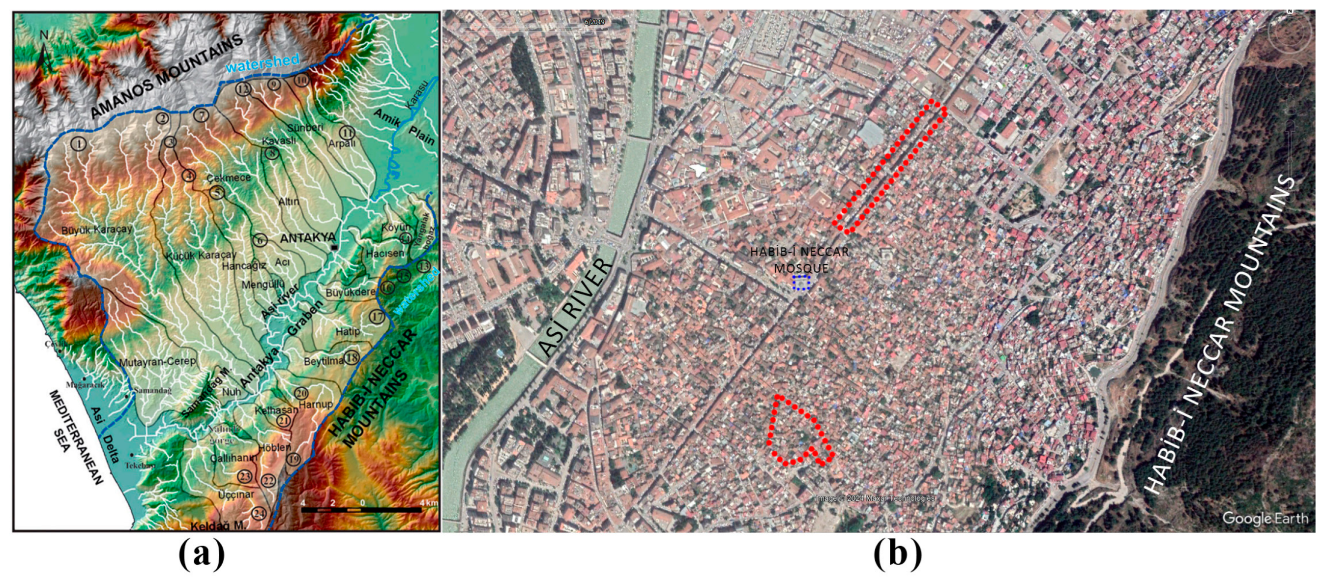
Antakya is a multi-layered historic settlement accommodating the heritage of different civilizations, including Hellenistic, Roman, Seljuk, Crusader, Mamluk, Ottoman, French, and the Turkish Republic. It experienced catastrophic earthquakes throughout history as well. As for the geographical characteristics, Antakya is surrounded by Mount Amanos (Nur Mountains) to the north, Mount Kel to the south, Mount Habib Neccar to the east, and the Amik Plain to the northeast, with the Eastern Mediterranean Sea lying to the southwest of the city [32]. The case study sites of Kurtuluş Street and Kuyulu Neighborhood are located between the Asi River passing by the city and Habib-i Neccar Mountains (Figure 4). Antakya has similar qualities to heritage cities from nearby areas of Palestine, Tunisia, Morocco, with its organic settlement patterns created through dead-ends and introverted courtyard-houses. Its Greco-Roman grid plan, on the other hand, is reminiscent of Hellenistic and Roman cities such as Naples, Rome, L’Aquila, Athens, etc. The uniqueness of Antakya is the combined city layout, turning from a Hippodamian grid towards an organic morphology, which is similar to İstanbul in that aspect. Kurtuluş Street is the main component of the grid plan, while Kuyulu Neighborhood is representative of the organic morphology.
In the following sections, the heritage characteristics of Kurtuluş Street and Kuyulu Neighborhood are explained based on 2019 site survey data [33].

3.1.1. Building Periods

The buildings in Kuyulu Neighborhood and Kurtuluş Street are classified into five categories based on construction periods: the Ottoman Period, Late Ottoman Period (1852–1918), French Period (1918–1938), Turkish Republic Period (1938–1987), and Turkish Republic Period (after 1987). The 1852 earthquake in Antakya marks the beginning of the Late Ottoman Period, with buildings from this era presumed to have been erected subsequently. The Late Ottoman influence persisted until 1918, after which French-style architecture emerged during the French occupation (1918–1938). From 1938 onward, Early Republican Period buildings were introduced. Following 1987, changes in building permits led to the construction of riser buildings exceeding three stories. On Kurtuluş Street, 37% of the buildings date from the Turkish Republic Period (after 1987) and 31% from the French Period (1918–1938), with the Turkish Republic Period (1938–1987) representing the third most common style. Additionally, several hybrid designs exist, displaying designs from different periods, such as Late Ottoman ground floors with Turkish Republic upper floors, or combinations of the Ottoman and French Periods. In Kuyulu Neighborhood, 58% of buildings were built in the Ottoman Period. The other most common periods were the Turkish Republic Period (1938–1987) and the combined designs of the Ottoman Period and Turkish Republic Period (1938–1987). Single examples of the Late Ottoman and the combined design of the French Period and Turkish Republic Period (1938–1987) were present as well. In the mapping, five periods are represented by five different colors; the buildings that display the two different periods’ characteristics on different floors are colored in two colors, representing related periods (Figure 5).
As a result, Early Republican buildings (1938–1987), not exceeding three stories, were in harmony with the historic silhouette, while those built after 1987 altered the skyline with their four to five stories, especially on Kurtuluş Street.

3.1.2. Road Network Morphology

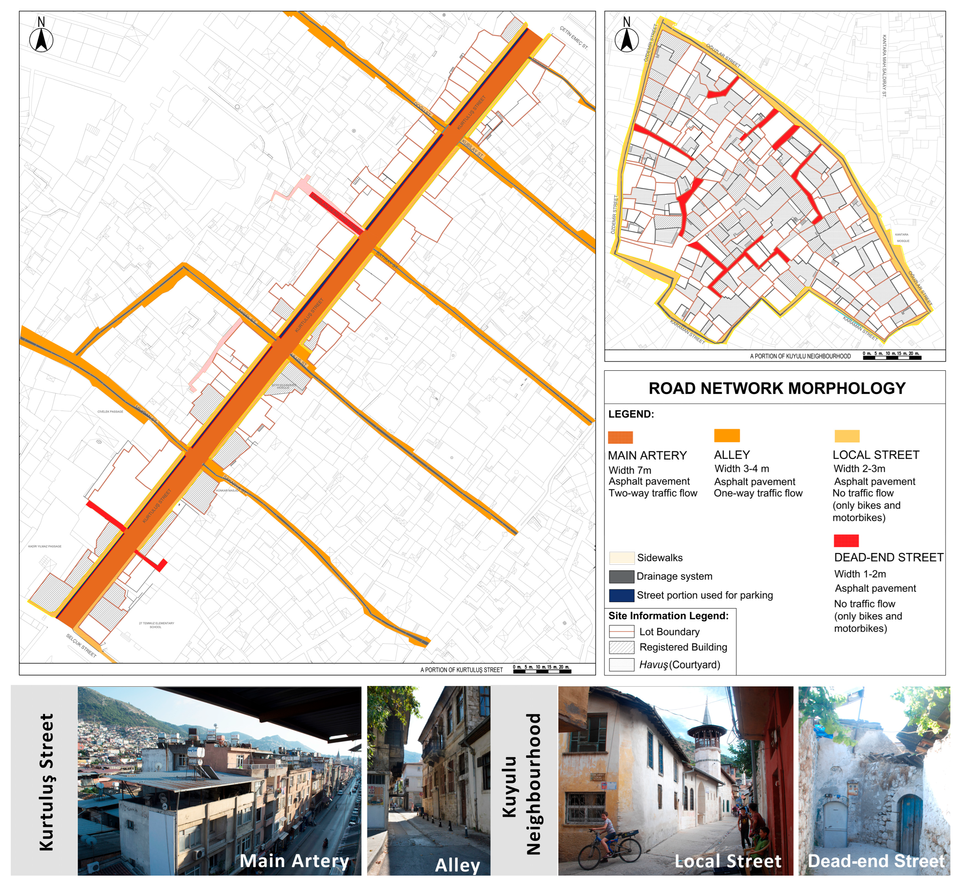
The road types are grouped under four headings: main artery, alley, local street, and dead-end street. The main artery has the qualities of 7 m width, two-lane traffic flow, and asphalt pavement allowing public transportation. It has sidewalks at both sides. Kurtuluş Street is classified as the main artery. Alleys have a width of 3–4 m and are covered with asphalt. The perpendicular streets connecting to Kurtuluş Street are mainly in this category. Local streets have a width of 2–3 m, with asphalt covering and a groove design in the middle of them for water drainage. They have no traffic flow; only motorcycle or bicycle vehicles can enter these narrow roads. The roads surrounding Kuyulu Neighborhood are in this category. Dead-end streets are 1–2 m in width, with asphalt covering. This street type is common in the organic road network of Kuyulu Neighborhood. A few dead-end street examples are present on Kurtuluş Street as well (Figure 6). In conclusion, Kurtuluş Street represents the urban grid morphology of the Hellenistic Period, the colonnaded street of the Roman Period, and its re-establishment in the French Period through the demolition of Ottoman Period buildings. On the other hand, Kuyulu Neighborhood represents the conversion of the grid layout to an organic one in the Ottoman Period. This organic settlement morphology, with narrower roads and dead-end streets, provided privacy to the entrances of courtyard-houses.

3.1.3. Lot–Building Relationships

Kurtuluş Street and Kuyulu Neighborhood display different qualities in terms of lot–building relationships. On Kurtuluş Street, the buildings fit into the whole lot and there is no courtyard design. However, in Kuyulu Neighborhood, there are four different types of lots based on the location of the courtyard, and a fifth type, where the building mass fits into the whole lot, is also observed. These types can be described as follows:
Type 1: The courtyard is accessed directly from a local street. The main building flanks the rear side of the courtyard. An estimated 67% of the total lots in Kuyulu Neighborhood are in this group.
Type 2: The main building is accessed directly from a local street. There is a rear courtyard. An estimated 9% of the total lots in Kuyulu Neighborhood are in this group.
Type 3: A narrow passage provides access from a local street to the rear courtyard. The main building flanks the street side of the courtyard. An estimated 20% of the total lots in Kuyulu Neighborhood are in this group.
Type 4: The courtyard is accessed directly from a local street. The main building flanks the rear side of the courtyard. A secondary entrance provides access to the first floor of the main building. An estimated 2% of the total lots in Kuyulu Neighborhood are in this group.
Type 5: The main building is accessed directly from a local street. There is no courtyard. An estimated 2% of the total lots in Kuyulu Neighborhood are in this group, with all the lots in this type being on Kurtuluş Street (Figure 7).
The lot–building relationship variety in Kuyulu Neighborhood, based on the authentic havuş (courtyard) location differences, is a valuable aspect that should be conserved. The adjacent row-housing system without any courtyards on Kurtuluş Street is also a unique characteristic for that site, giving it authenticity as well.

3.1.4. Figure–Ground

Along Kurtuluş Street, shop-houses flank one another. Roads are the only open spaces. Kuyulu is less dense with local streets, dead-ends, and courtyards. Excluding the streets, solids make up 99% of the lots on Kurtuluş Street, while the same ratio is 70.2% in Kuyulu Neighborhood (Figure 8).

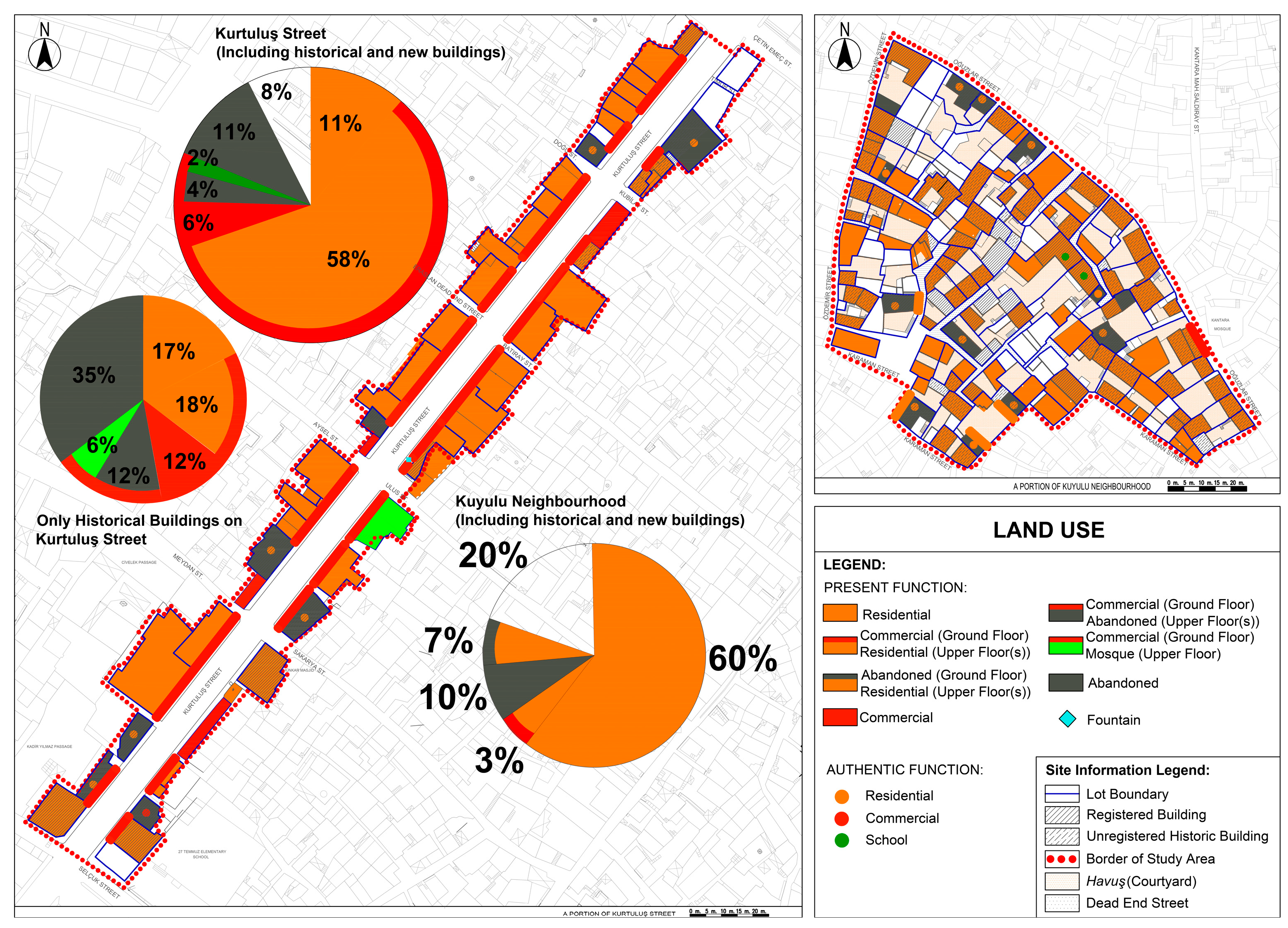
3.1.5. Land Use

Kurtuluş Street accommodated mixed functions, such as commercial ground floor, residential upper floor (58%); commercial ground floor, abandoned upper floor (4%); and commercial ground floor, mosque on the upper floor of one building (2%). Furthermore, totally abandoned (11%) and commercial (6%) land use existed. A few instances of land use could not be observed (8%). In turn, the commercial–residential combination was the most common, representing the authentic state. However, when only historic buildings were considered, 35% were totally abandoned, while 12% were abandoned on the upper floor.
In Kuyulu Neighborhood, most of the buildings had residential usage (60%). Most of these buildings had residential usage in their authentic state, while a few of them had two functions: commercial and residential (7%). Two of the residential buildings were schools originally. Therefore, the authentic land use was generally preserved. Totally abandoned (10%); abandoned ground floor, residential upper floor (7%); and commercial ground floor, residential upper floor (3%) were observed as well. There was only one building that had a commercial function as a local market in the neighborhood. An estimated 20% of the buildings were unobserved (Figure 9).

3.1.6. Number of Stories

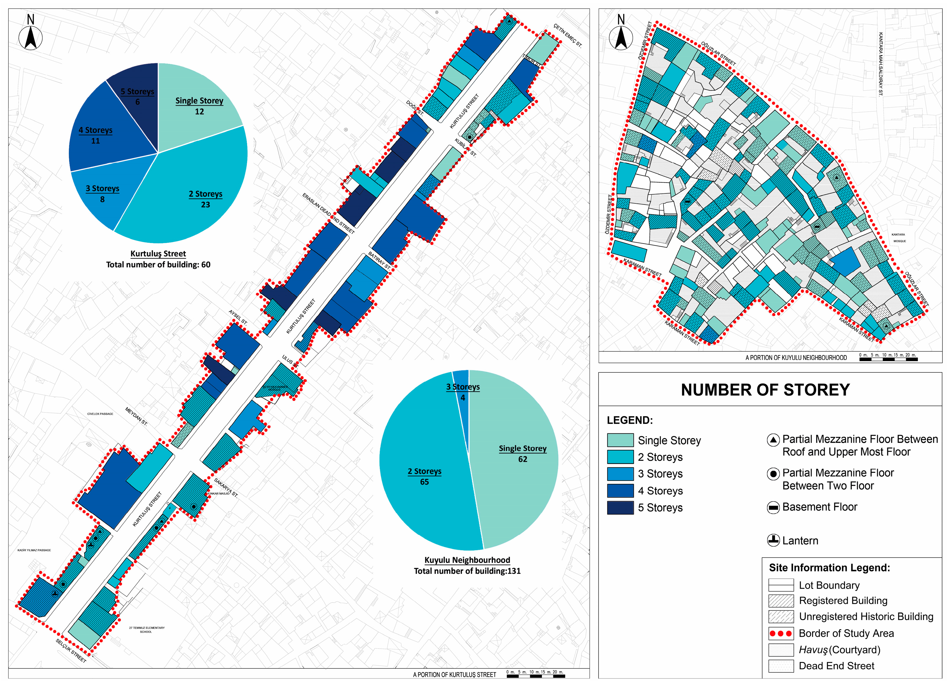
On two sides of Kurtuluş Street, there were 60 buildings in total. One third were two-storied (23). Four- or five-storied buildings were also common (17). Three-storied buildings and abandoned ones were occasionally seen: 8 and 12, respectively. In Kuyulu Neighborhood, there were 131 buildings in total. Almost half were single-storied (62). The other half were two-storied (65). Three-storied ones were rare (4). In both sites, authentic skylights (2 on Kurtuluş Street), mezzanines (6 on Kurtuluş Street, 2 in Kuyulu Neighborhood), and basements (2 in Kuyulu Neighborhood) were rarely observed and are indicated with symbols on the map (Figure 10).
The skyline change, damaging the authentic silhouette of Kurtuluş Street and the city, is represented by the existence of four- or five-storied buildings. In comparison to Kurtuluş Street, the skyline is more preserved in Kuyulu Neighborhood by a majority of one- or two-storied buildings and only four three-storied ones.

3.1.7. Spatial Characteristics

On Kurtuluş Street, the typical scheme of ground floors was a series of shops (68.5%) and a linear hall (16%) leading to the upper floors. Offices and service spaces were rare: 11.4% and 4.1%, respectively. In Kuyulu Neighborhood, authentic courtyards (havuş, 64%) were the datum element on the ground level. Although indigenous vegetation was often preserved (67.7%), the authentic wells (28%) and haymas, semi-open spaces spanned with ivies (4%), were less preserved and were rarely observed. Small metal canopies (18%) and roofs as wide as the courtyard (14%) were occasionally added. Rooms flanked the courtyards or were positioned on upper floors (32%). A single shop was seen. In both sites, residential spaces were the most common on upper levels. The first floors of Kurtuluş Street included rooms (57.6%), halls (31%), and service spaces (11.6%). In Kuyulu Neighborhood, halls were seen on half of the first floors (46.6%). Halls and storage spaces were seldom present: 14.4% and 18.9%, respectively. Services were hardly ever present (5.5%). Authentic spatial elements such as a sleeping space reached by a flight of wooden stairs hidden in the cupboard (taht/tahtlık) were also seen on some houses’ first floors. A semi-open living space extending to the courtyard (hayat) was recorded in a few houses as well (Figure 11).

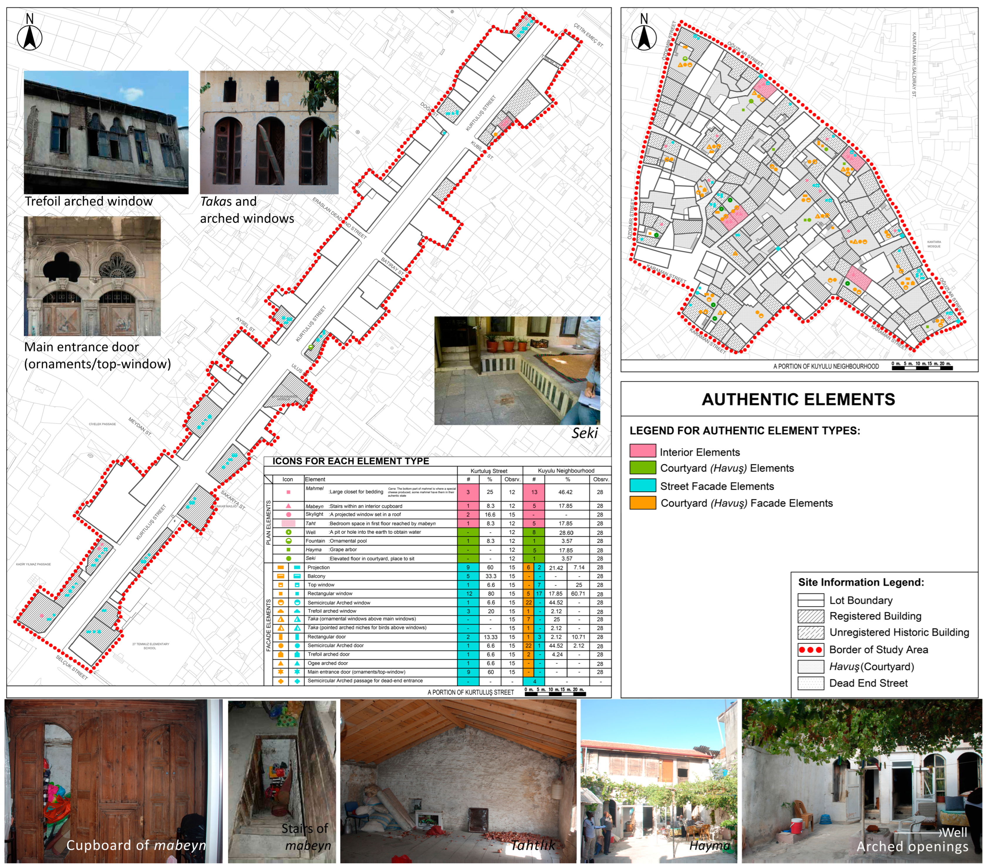
3.1.8. Authentic Elements

Authentic elements were grouped as interior, courtyard (havuş), street façade, and courtyard façade elements. The interior elements were mahmel, mabeyn, tahtlık, and skylight; courtyard (havuş) elements were well, fountain, hayma, and seki; and the façade elements were projection, balcony, top window, windows (rectangular, semicircular, or trefoil arched), taka, doors (rectangular, semicircular, trefoil, or ogee arched), main entrance door with ornaments and top windows, and semicircular arched passage for dead-end streets.
A mahmel refers to the large closet built into the walls to store bedding when it is not used. Generally, it was covered with a curtain. An estimated 46% of the observed houses in Kuyulu Neighborhood had a mahmel, while there were only two examples of a mahmel on Kurtuluş Street. The bottom part of the mahmel was used as the carra cheese production space as well.
The mabeyn is the hidden staircase located within the cabinet built into the masonry walls, and it connects the ground floor to the first floor. Only five examples were observed in Kuyulu Neighborhood.
The tahtlık is the hall (sofa)-like place where the mabeyn opens up on the first floor. In the past, women gathered there to socialize, while in 2019, it was used as a bedroom space or storage area.
A hayma is a lightweight grid structure built of wooden or metal materials and supporting the ivy in the courtyard (havuş). It created a shady area to sit under in summer.
A taka is a small opening above the windows, used either as a top window to let in daylight or as a birdhouse. Some of them had ornamented designs, enriching the façade design.
A seki is a slightly higher level designed to sit in courtyards (havuş). There was only one authentic seki recorded in 2019, which was in Kuyulu Neighborhood (Figure 12).

3.1.9. Housing Unit Typologies

The main parameters considered while determining house types were the main circulation element (courtyard or hall) and the positioning of building masses or rooms around them. For the sub-types, in Kuyulu Neighborhood, the symmetry/asymmetry of building façade openings, the existence of a hayat space, the presence of a taka, and the number of stories were sub-parameters, while on Kurtuluş Street, the symmetry/asymmetry of building façade openings and the design of the balcony door in harmony with the hall constituted the sub-parameters.
Kuyulu Neighborhood Typologies
In Kuyulu Neighborhood, the courtyard (havuş) was the datum element. Therefore, the dispositioning of the main mass around the courtyard created variations in typology. The main masses were either one- or two-storied, and some of the two-story ones had a hayat space.
Courtyard walls were blind, with only an arched door opening. Rooms facing a havuş had arched windows and door openings, as well. The “taka” was a special opening type designed for birds or to allow in light from the top level. As a result, specific typology parameters for Kuyulu Neighborhood are the number of stories, the presence of a hayat, the presence of a taka, and the symmetric/asymmetric organization of arched openings.
  • The first typology was “courtyard juxtaposed at one side by main mass,” which included one- or two-story buildings, and just three of them had traces of a taka above the ground-floor windows. Its subheadings are mainly “1.1. Courtyard juxtaposed at short side by main mass,” “1.2. Courtyard juxtaposed at long side by main mass,” and “1.3. With a big squarish courtyard,” as shown in Figure 13. As a rare example of the “courtyard juxtaposed at long side by main mass” type, two examples were seen with a hayat space on the first floor. On the first floor, openings had cinquefoil arches, and they faced the hayat space, while on the ground floor, either segmental arched or rectangular openings existed. The facades had asymmetrical organization. The only example belonging to the “with a big squarish courtyard” typology had a garden wall addition separating the courtyard in the middle. Therefore, the façade of the building, which was used as a French school for a period, was also divided into two. The façade organization was symmetrical, and the ground-floor openings had ornamented taka designs above them, which differentiated the building and made it a rare example for the site.
  • The second typology was “courtyard juxtaposed at two sides by masses.” In this typology, the living area and wet spaces were located in two different masses around the havuş. Its subheadings are mainly “2.1. Courtyard juxtaposed at its two opposing short sides by main masses” and “2.2. Courtyard juxtaposed at its two opposing long sides by main masses,” as shown in Figure 14. In the second sub-type, the openings as windows, takas, and doors had level differences between adjacent masses with different mass heights.
Kurtuluş Street Typologies
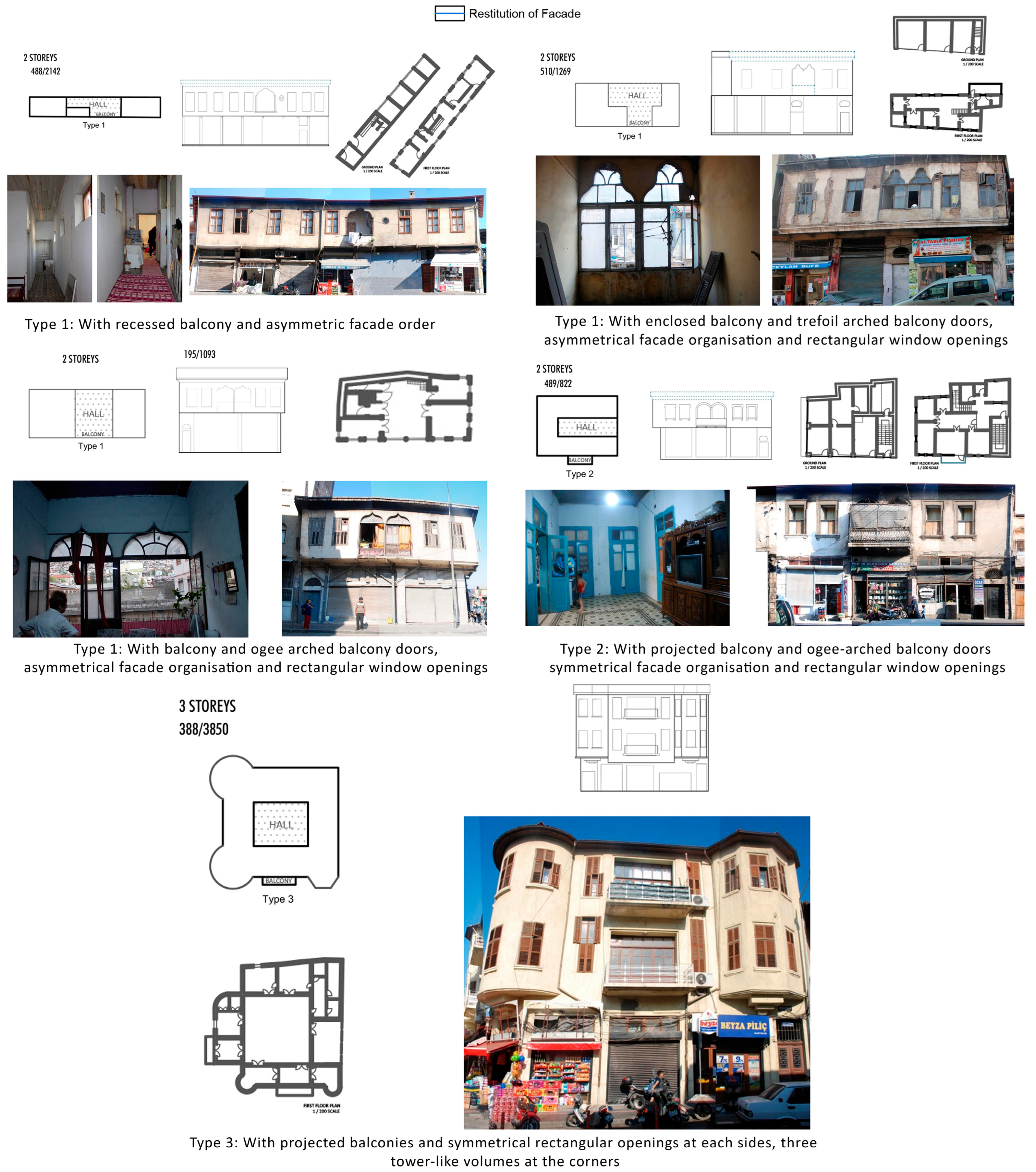
On Kurtuluş Street, there were two-story historic buildings that had a commercial function on the ground floor and a housing function on the first floor. The datum element in housing unit typology was the hall, and there were specially designed door openings for balconies in these halls in most cases.
First-floor window openings had a rhythm and were placed asymmetrically or symmetrically on two sides of the balconies. In commercial spaces on the ground floor, there were rhythmic shutters and ornamented main entrances leading up to the housing spaces on the first floors. These entrances had stone casings around them. The number of entrances differed in each building from one to three. On the first floor, most of the buildings had a projection towards Kurtuluş Street. The windows also had a rhythm, and in the middle of those window openings a balcony space could be located. The roofs had curvilinear eaves designed with metal material and were covered with over- and under-tiles. Its subheadings are mainly “1. Hall juxtaposed at two sides by rooms,” “2. Hall juxtaposed at three sides by rooms,” and “3. Central hall,” as shown in Figure 15. The third typology differed from the previous typologies observed on the site and had the possibility to be used as a governmental building in a period with similar architectural elements to the Historic Assembly Building of Antakya, dating to 1927.
On Kurtuluş Street, the most common type was the “hall juxtaposed at two sides by rooms” (62.5%). It was followed by the second type, “hall juxtaposed at three sides by rooms” (25%), and then by a single example of “central hall” (12.5%).
In Kuyulu Neighborhood, “courtyard juxtaposed at one side by main mass” was common (73.6%), and the second type, “courtyard juxtaposed at two sides by masses” (26.4%), was seen in a smaller percentage.
In conclusion, the unique spatial organizations based on courtyard or hall datum elements are components of authenticity directly related to the inhabitants’ lifestyles as well.

3.1.10. Structural System Types

The combined structural system and the masonry system were the main types observed in heritage buildings on Kurtuluş Street and in Kuyulu Neighborhood. The buildings with the combined structural system had ground-floor walls built with the masonry system, first-floor walls built as timber frame walls with infill, the floor-on-ground system as the ground-floor type, and the timber roof system for the roof system. The subtypes for this system type were formed according to their first-floor system type. The timber floor system, cross vault, reinforced concrete floor system, and reinforced concrete floor system supported with I beams created the subtypes.
For the masonry system, the common characteristics were complete masonry walls on all floors and the floor-on-ground system on the ground floor. Again, the type of first-floor system determined the subtypes. The timber floor system, cross vault, reinforced concrete floor system, and, for single-story types, a reinforced concrete slab as a terrace roof system constituted the subtypes. For the first three sub-types, the roof system was the timber roof system.
The third type was the reinforced concrete frame system observed in new buildings.
Since on Kurtuluş Street, there were more new buildings than historic buildings, the reinforced concrete frame system was the most common system type (64%). Among historic buildings, the combined structural system was common (20%), while the masonry system was rarely observed (8%). The reinforced concrete floor system supported with I beams was the most common subtype on Kurtuluş Street among historic buildings, followed by the timber floor system, cross vault, and reinforced concrete floor system. There were two types of timber frame walls of the first floor in historic buildings: with wood lath application (hımış) and with brick infill.
In Kuyulu Neighborhood, the masonry system was often seen (45%). Then, the reinforced concrete frame system was observed in new buildings (25%), while the combined system was rarely seen (10%) in this site. The masonry walls were built with either rubble stone or cut stone masonry material.
For the total evaluation of the two sites, because of the existence of new buildings, the most common structural system type was the reinforced concrete frame system (45%), followed by the masonry system (35%) and then the combined system (14%) (Figure 16).

3.1.11. Conservation Conditions

The conservation condition of historic buildings were grouped under four categories as good, moderate, poor, and ruin:
Good: No structural failure, local material deterioration;
Moderate: Local structural failure, widespread material deterioration;
Poor: Near loss of structural integrity;
Ruin: Collapsed.
The buildings only observed from the exterior were framed on the map (Figure 17), while the ones observed from the exterior and interior were hatched. For the exterior survey analysis, most of the buildings in both sites were in good condition. Then, a moderate state was seen in a 20–26% range in the two sites. On Kurtuluş Street, the remaining part was in a condition of ruin, in equal proportion to the moderate-state type (20%), while in Kuyulu Neighborhood, buildings in poor (16%) and ruin (5%) state existed.
For buildings to which both interior and exterior surveys were applied on Kurtuluş Street, mostly (50%) moderate-state buildings were observed, while in Kuyulu Neighborhood, buildings in good state were often seen (60%). On Kurtuluş Street, buildings were in poor (25%), good (17%), and ruin (8%) condition, and in Kuyulu Neighborhood, moderate (26%), ruin (8%), and poor (6%) conditions were also seen.
In the total evaluation of both sites considering all survey types, the conservation conditions with percentages were as follows: good (52%), moderate (29%), poor (11%), and ruin (8%) (Figure 17).
In conclusion, on Kurtuluş Street, the combined system buildings were either in moderate or poor condition mostly, while in Kuyulu Neighborhood, good and moderate conditions were common for the masonry system, which can be useful for resistance evaluation of different historic structural system types.

3.1.12. Alterations

The alteration types are evaluated under four main headings as urban scale, lot scale, building scale, and element scale. At the urban scale, renewal was extensive (69%) on Kurtuluş Street: Mainly three-, four-, or five-story structures were built in place of historic ones, damaging the skyline. In Kuyulu, the authentic silhouette of the neighborhood was preserved, excluding a single three-story building and a few one- or two-story ones (22%). Lot-scale interventions, especially mass additions to the courtyards, were frequently seen in Kuyulu (75%). Lot invasion was seen at a rate of 8% on Kurtuluş Street and 11% in Kuyulu Neighborhood, while lot division was only seen in Kuyulu Neighborhood at a rate of 4%. At the building scale, story addition (21%), renewal (14%), or loss (11%) were only observed in Kuyulu Neighborhood. Space division was seen at a rate of 25% on Kurtuluş Street and 7% in Kuyulu Neighborhood. Roof addition was 32% in Kuyulu Neighborhood and function change was 7% in Kuyulu Neighborhood. At the element scale, element change (44%), loss (44%), addition (31%), and conversion (19%) were more frequently seen on Kurtuluş Street than in Kuyulu Neighborhood (26%, 13%, 13%, and 15% respectively).
To sum up, the integrity of the historic fabric was damaged with building renewals and element alterations on Kurtuluş Street. The filling in of courtyards in Kuyulu Neighborhood partially altered the original solid–void balance (Figure 18).

3.2. Values, Problems, and Potential of Sites Before and After the Earthquake

Heritage value identification is important to understanding the cultural significance and authenticity of historic urban landscapes with different attributes [35,36,37].
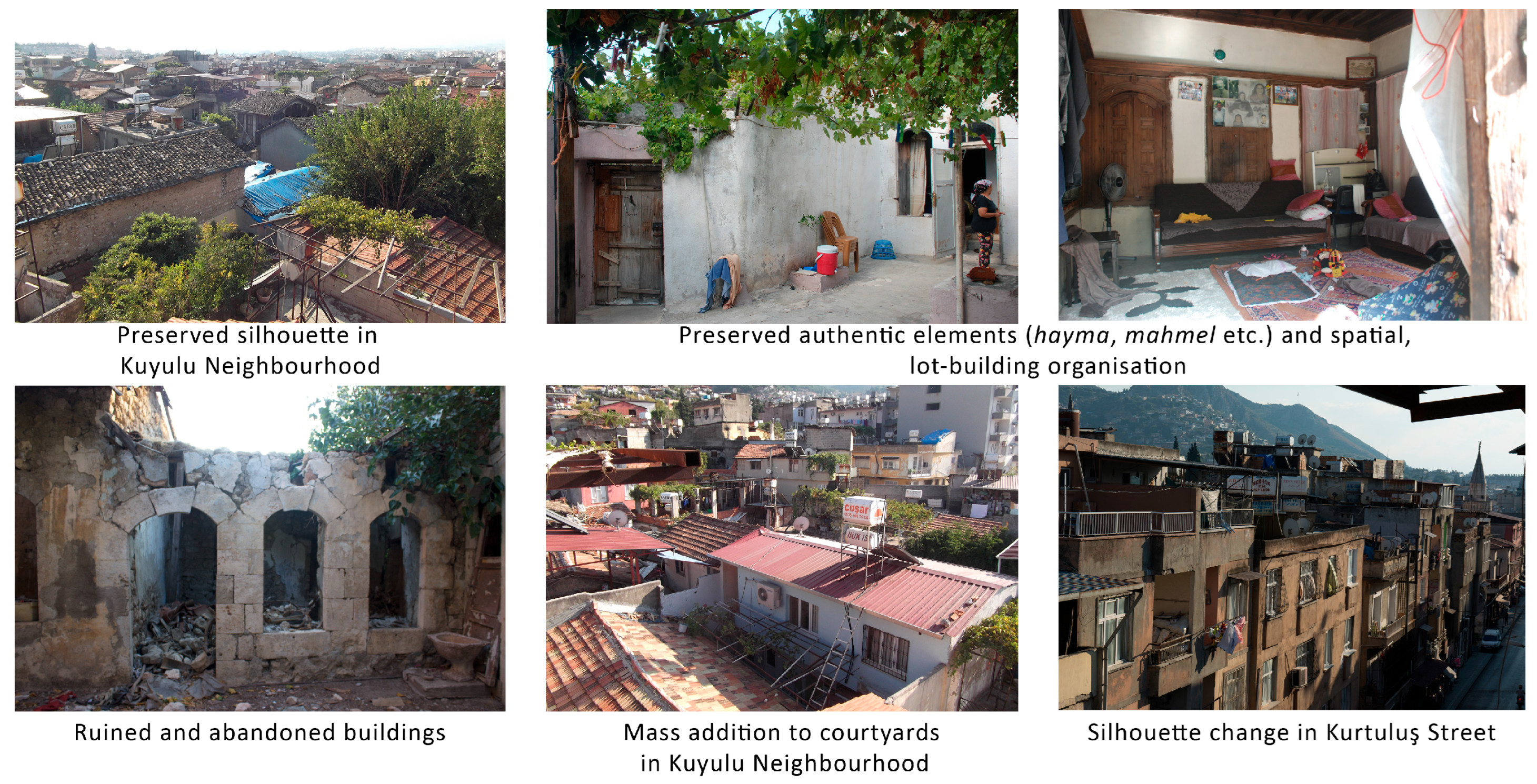
For physical aspects, the preserved silhouette, authentic settlement patterns, street hierarchy, and longevity of original functions are site-scale values that can be identified as environmental and architectural value. The authentic lot organizations in Kuyulu Neighborhood and on Kurtuluş Street as organization around a courtyard (havuş) and full settlement into the lot, respectively, created unique characteristics for the sites that, again, can be called environmental value. On the building scale, diverse spatial organizations held architectural, aesthetic, and rarity value. The relatively older houses of Kuyulu Neighborhood carried age value. Diverse construction techniques reflecting the scope of their periods represented technological value. Extensive open space usage for communal activities (courtyards, terraces, local, or dead-end streets), feeding pigeons, maintaining close relationships with neighbors, joint preparation of food for winter, and preparing cuisine (carra cheese and growing grapes in courtyards) defined an indigenous lifestyle in Kuyulu, which could be evaluated as the intangible heritage.
On the other hand, the high number of buildings in ruin, poor, or moderate conservation conditions threatened the sustainability of both sites. The lack of maintenance or abandonment were the basic causes of structural integrity loss. Alterations such as mass additions, the closing of courtyards with metal roofs, story additions, and architectural element changes diminished the authenticity of the CH sites. On Kurtuluş Street, integrity was partially lost with the alteration of the silhouette. Heavy traffic on Kurtuluş Street was a threat to the authentic spirit of place as well as the structural integrity of the CH buildings. The tendency to leave the neighborhoods for better comfort conditions in Kuyulu and Syrian immigrants preferring the houses on Kurtuluş Street for rent hindered the continuity of the local way of life. Nevertheless, the abandoned buildings have adaptive reuse potential, e.g., socio-cultural hubs; local health centers, education and training facilities, especially for women; houses for marketing household products to the locals, and hostels for youth and cultural tourists. The existence of conserved authentic buildings creates a reference for alteration recovery plans in the changed authentic buildings (Figure 19).
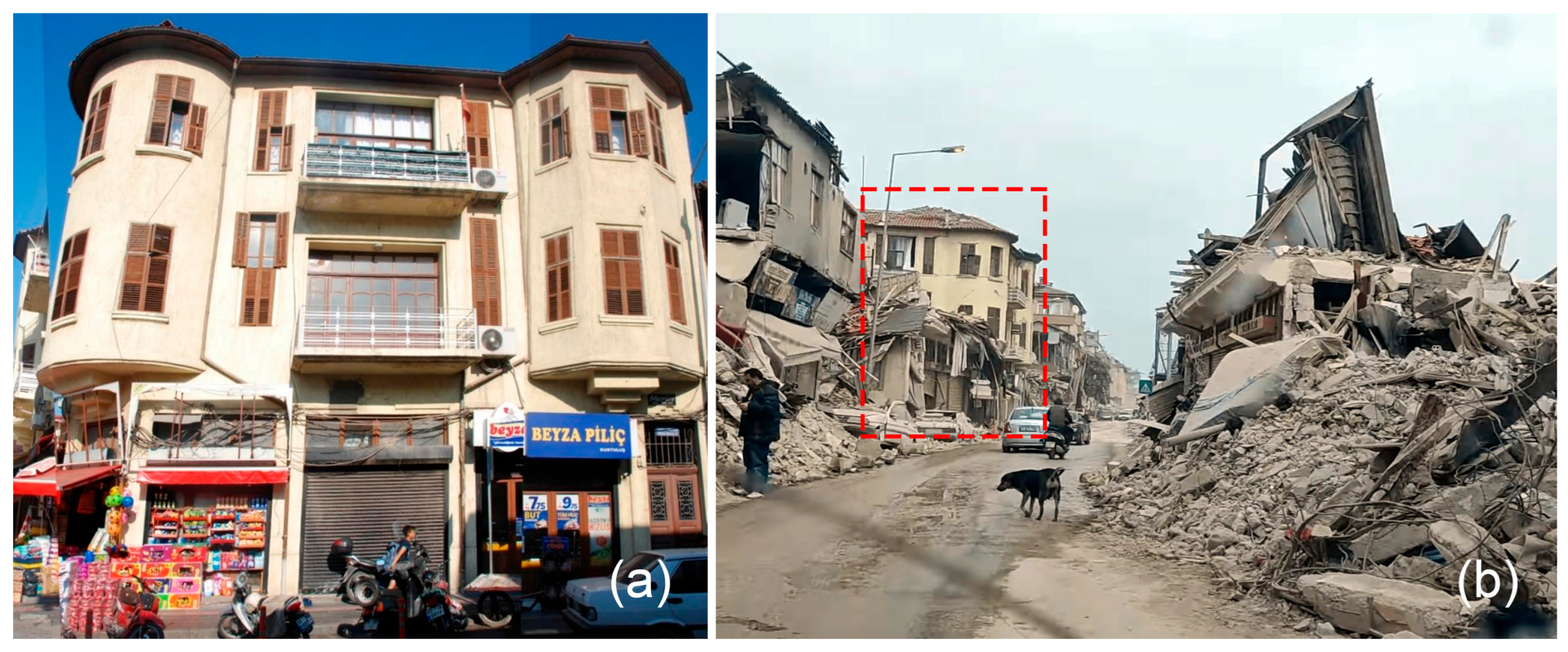
Since the earthquake in 2023, the authentic axial layout of Kurtuluş has been reestablished by removing the debris of the demolished structures along the street. Therefore, the main artery pattern can still be observed. Alleys connecting to the street can mainly be deciphered as well. Only one historic building on the street from the French Period sustained its integrity. It has a masonry system different from other French Period houses on the street built with the combined system. Furthermore, it has a different typology from the other French buildings on the street due to having a central hall and three tower-like volumes projected at the corners of the building mass. Therefore, as the only authentic historic structure sustained, it has acquired rarity value, in addition to its architectural, technological, and documentary value (Figure 20).
In Kuyulu, the overall organic pattern representing the Ottoman era can be traced out after the removal of debris. However, the dead-ends are not legible because of extensive loss of buildings and courtyard walls. Nevertheless, the number of buildings that survived after the disaster is higher than on Kurtuluş Street because of the masonry system being the preferred construction technique instead of the combined system, which decreases the integral behavior of the structural components, less number of stories andbuilding heights, and the placement design of the authentic building masses independent from their neighbors. The multi-layered quality of both sites can still be traced thanks to the remnants (Figure 21).
The remaining characteristics should be considered representative of the environmental, architectural, technological, and documentary value of the sites. However, rapid removal of debris with limited documentation [40,41] hinders the options for conservation and presentation. The high number of deaths and the impossibility of sheltering in place for the surviving locals due to poor structural condition and a high rate of demolishment are major problems threatening the sustainability of intangible heritage. Creative strategies for mitigating future earthquake risks, adapting historic structures to earthquake hazards, increasing the legibility of sustained authentic qualities through a comparative approach of the available remains and archive documents, developing blended-learning programs of risk management for all stakeholders, and ensuring the strengthening of socio-cultural resilience through community engagement are indispensable for enlivening the spirit of historic urban landscapes.

4. Discussion: Authenticity and Community-Based Strategies for Interventions

By considering the authenticity parameters defined in conservation charters for historic urban landscapes, and the latest guides for the post-disaster and post-conflict recovery and reconstruction for heritage places of cultural significance [1,2,4,5,7,8,10,11,13,15,16], the following strategies can be followed for Kurtuluş Street and Kuyulu Neighborhood in post-earthquake interventions and new building constructions:
For Building Periods: After the earthquake disaster, the periodic layers of the sites disappeared on a major scale. The remaining ones on Kurtuluş Street and in Kuyulu Neighborhood should be kept as precious remains, being the last representatives of the periodic layering. Following any necessary emergency consolidations, their interdisciplinary assessment is indispensable for deriving generalizable principles for physical resilience. Why they survived while many others did not should be understood well.
For Road Network Morphology: Although the dead-end street forms have disappeared in Kuyulu Neighborhood, the local streets encircling the site are still readable. In the Kurtuluş Street case, in addition to the main artery, traces of some alleys still exist. In principle, establishing evacuation routes as part of risk preparedness and adaptation [42], while reconstructing the authentic network within the limits of preserved traces and documents, is suggested since it contributes to socio-cultural resilience, e.g., dead-ends fulfilling the privacy needs of the community.
For Lot–Building Relationships: Due to mass destruction, lot–building relations are hardly legible. In reconstructions, the valuable variety of lot–building relationships centered on havuş placement in Kuyulu Neighborhood and the characteristic lot–building relationship as fitting to the whole lot without open space on Kurtuluş Street should be enlivened to sustain the cultural authenticity. However, any adaptation measure necessary for improving the structural resilience of buildings through their placement should be undertaken, based on further interdisciplinary assessment.
For Figure–Ground: Havuş spaces in Kuyulu Neighborhood and on Kurtuluş Street, as the linear artery dating back to the Hellenistic Period, should be revitalized as distinctive voids. Variety in building placements in Kuyulu and sequential building masses that fit perfectly into their parcels on Kurtuluş Street should also be sustained in new designs. However, adaptations should be made to enhance physical resilience and mitigate the risk of collapse in a future earthquake, based on further interdisciplinary assessment.
For Land Use: Residential usage that has continued for centuries in Kuyulu and the authentic shop houses along Kurtuluş Street should be preferred for reconstructed or consolidated buildings. However, socio-cultural resilience can be improved by introducing facilities such as education and health services, as well as community centers, whose absence was documented in pre-disaster surveys. A community-based decision-making process, led by further focus group discussions, is suggested for structuring the program of post-disaster adaptive reuse of both sites [43,44,45,46,47].
For Number of Stories: The reconstructions in Kuyulu Neighborhood can reestablish the authentic silhouette, consisting of a rhythmic organization of one or two stories. On Kurtuluş Street, the height of the historic French-style buildings, which were two stories, should be respected as part of the authentic skyline. Any new construction that surpasses the integrity of the proposed silhouettes should be avoided, allowing genuine indicators of cultural memory to remain intact.
For Spatial Characteristics, Authentic Elements, and Housing Unit Typologies: In Kuyulu Neighborhood, the havuş is not only the datum element of housing units but also an indispensable yet private open space enriched with secondary building elements in a Mediterranean neighborhood. This domestic spirit should be restored, considering climate change and earthquake risk adaptation requirements, which will be revealed with further interdisciplinary research. On Kurtuluş Street, the authentic shophouse typology and contributions of the Early Republican Period can be restored within the limits of the available archive documents. Similarly, any measures necessary for improving physical resilience while respecting the overall authentic spatial organization with all its layers are suggested.
For Structural System: As is revealed by the extensive number of collapsed historic buildings in both CH sites, the local construction techniques need improvement to resist seismic forces. The surviving exceptional historic buildings can be further assessed to guide the improvements. Comparisons with pre-disaster data should be carried out. Therefore, rather than prioritizing modern construction systems, whose structural reliability may also be contested, greater emphasis should be placed on reinforcing and advancing local construction techniques that have evolved over time. Further interdisciplinary research is necessary to propose a scope that guarantees the physical resilience of structures [48] whose consolidation or reconstruction is suggested.
For Alterations and Conservation Conditions: Pre-disaster data should be carefully examined to evaluate the impact of alterations and conservation conditions on the survival rates of structures. Alterations that have played a role in collapses (e.g., story loss/addition, mass addition) should be avoided in the reconstructed neighborhood through a risk management plan guaranteeing the active contribution of all stakeholders. Monitoring and regular maintenance [1,2,4,6,11,13,15,16,17] should be achieved as part of this management work.
For Socio-Cultural Aspects: The remaining local people hold the most valuable potential for revitalizing the spirit of heritage sites by preserving their collective memory and sustaining their traditional way of life. SSH specialists should play an active role in the revitalization of both neighborhoods so that maximum interaction of the policymakers, NGOs, and residents can be achieved for the social well-being of the locals. Therefore, innovative strategies for enhancing community resilience planning while sustaining cultural memory are crucial, e.g., community-based indicators for revitalizing the local way of life. Havuş, local streets, and dead-ends, as major elements of social interaction and a sense of belonging, should be revitalized and enhanced. Policymakers, the economic sector, SSH specialists, engineers, architects, and locals should provide continuous engagement for improving resilience while preserving the values. Considering community-based indicators for socio-cultural resilience and developing training programs, especially for youth, on the indigenous knowledge, skills, and crafts of Antakya is crucial for providing community involvement in the reconstruction process of urban heritage [49]. At the same time, integration and educational initiatives can be developed to foster a more harmonious coexistence between immigrants and locals, provided that the immigrants choose to remain in Antakya.
The generated value-based intervention strategies are structured around authenticity themes, exploring how each theme can enhance its own characteristic to regenerate damaged historic urban landscapes. This approach helps to understand the genius loci of heritage sites, which is beneficial for designing successful regeneration projects in historic urban areas [50]. At the same time, the improvement of the resilience of CH urban sites after earthquake disasters is suggested through adaptation measures developed for each theme. The decision support system presented in this study can be applied to various historic urban landscapes by defining their unique characteristics for each authenticity theme before the disaster and then utilizing this knowledge in the post-disaster state to regenerate the heritage sites and improve their resilience.

5. Conclusions

Earthquake risk preparedness of historic urban sites necessitates pre-disaster documentation of authentic qualities: construction periods, road network morphology, lot–building relationships, figure–ground patterns, land use, number of stories, spatial configurations, authentic architectural elements, housing typologies, structural systems, degrees of alteration and conservation, and socio-cultural characteristics. Balancing the preservation of authenticity and physical and socio-cultural resilience is required. A comparison of the post-disaster condition of historic urban sites with pre-disaster data reveals valuable information for guiding recovery work.
The central research question of this study explores how the pre-disaster values and authentic qualities of historic urban sites can inform intervention planning, thereby revitalizing the heritage character in the regenerated post-disaster context.
As an outcome of this research, a decision support system is developed, outlining strategies for managing post-disaster interventions grounded in the pre-disaster documentation of heritage values. It is applied to two portions of the historic urban site of Antakya: Kurtuluş Street and Kuyulu Neighborhood, both of which were severely impacted by the catastrophic 7.7-magnitude earthquake in 2023. Aerial imagery reveals that the majority of the heritage buildings in these areas were destroyed. Consequently, the few remaining historic structures and residual traces of urban morphology are now considered vital elements, representing the last tangible evidence of historical stratification.
The overarching approach to strategy development based on the authenticity parameters defined in conservation charters, standards, and guidelines advocates for the revitalization of essential site characteristics that contribute to the spirit of place and the cultural identity of the local community. This is to be achieved by adhering to the design principles reflective of the site’s authentic characteristics observed before the disaster.
Regarding structural systems, central both to enhancing resilience against future disasters and aligning with the “Build Back Better” framework, an understanding of the construction techniques employed in surviving historic buildings can serve as a foundation for both the consolidation of existing structures and the development of new ones. A contemporary structural approach considering the development of authentic construction techniques should be formulated for reconstructed buildings, replacing lost traditional houses with an interdisciplinary approach. In addition, the socio-cultural characteristics intrinsic to the sites should play a vital role in informing new design interventions.
The decision support system can be further supported with interdisciplinary assessments, e.g., structural engineers, geologists, city planners, etc. Authenticity definitions stemming from sustaining lot–building relations, construction techniques, etc., in conservation documents should be reconsidered together with resilience definitions, e.g., the adaptation of building placements and construction techniques in light of interdisciplinary assessments based on a comparison of pre- and post-disaster states. The contribution of SSH specialists is required in both pre- and post-disaster work for sustaining the spirit of place while improving socio-cultural resilience. In conclusion, this study demonstrates how pre-disaster documentation can be effectively leveraged to guide the development of intervention strategies within historic urban landscapes following catastrophic earthquake events. Future work will encompass interdisciplinary assessments for improving the planning of recovery work.

Supplementary Materials

The following supporting information can be downloaded at: https://www.mdpi.com/article/10.3390/architecture5040096/s1. Supplementary Material S1: Inventory sheets used in the site survey documentation process.

Author Contributions

Conceptualization, H.A.D. and M.H.T.; methodology, H.A.D. and M.H.T.; software, H.A.D. and M.H.T.; validation, H.A.D. and M.H.T.; investigation, H.A.D. and M.H.T.; data curation, H.A.D. and M.H.T.; writing—original draft preparation, H.A.D. and M.H.T.; writing—review and editing, H.A.D. and M.H.T.; visualization, H.A.D. and M.H.T.; supervision, H.A.D. and M.H.T. All authors have read and agreed to the published version of the manuscript.

Funding

This research received no external funding.

Institutional Review Board Statement

Not applicable.

Informed Consent Statement

Not applicable.

Data Availability Statement

All available data are contained within the paper. The site survey analysis mapping data presented in the study were created by our team, which are referenced as IZTECH 2019.

Conflicts of Interest

The authors declare no conflicts of interest.

References

  1. ICOMOS. The Washington Charter: Charter for the Conservation of Historic Towns and Urban Areas. 1987. Available online: https://www.icomos.org.tr/Dosyalar/ICOMOSTR_en0627717001536681570.pdf (accessed on 15 June 2024).
  2. ICOMOS. Valetta Principles for the Safeguarding and Management of Historic Cities, Towns and Urban Areas. 2011. Available online: https://civvih.icomos.org/wp-content/uploads/2022/03/Valletta-Principles-GA-_EN_FR_28_11_2011.pdf (accessed on 18 June 2024).
  3. ICOMOS. European Quality Principles for Eu-Funded Interventions with Potential Impact Upon CH. 2018. Available online: https://openarchive.icomos.org/id/eprint/2083/6/European_Quality_Principles_2019_EN_OK.pdf (accessed on 19 June 2024).
  4. Historic England. Conservation Principles, Policies and Guidance. 2008. Available online: https://historicengland.org.uk/images-books/publications/conservation-principles-sustainable-management-historic-environment/conservationprinciplespoliciesandguidanceapril08web/ (accessed on 20 June 2024).
  5. UNESCO. Recommendation on Historic Urban Landscape. 2011. Available online: https://whc.unesco.org/uploads/activities/documents/activity-638-98.pdf (accessed on 21 June 2024).
  6. European Committee for Standardization (CEN). Conservation of Cultural Property-Condition Survey and Report of Built Cultural Heritage, European Standard, EN16096. 2012. Available online: https://standards.iteh.ai/catalog/standards/cen/8f845d25-2dce-4edb-ba2a-b74a72267119/en-16096-2012?srsltid=AfmBOoq71NLyORLUv79KcM62qZVKTYegWbHBFSbleC2ANCJApsvOjOxx (accessed on 24 June 2024).
  7. ICOMOS. Guidance on Post-Trauma Recovery and Reconstruction for World Heritage Cultural Properties. 2017. Available online: https://openarchive.icomos.org/id/eprint/1763/19/ICOMOS%20Guidance%20on%20Post%20Trauma%20Recovery%20.pdf (accessed on 20 June 2024).
  8. UNESCO and The World Bank. Culture in City Reconstruction and Recovery. 2018. Available online: https://documents1.worldbank.org/curated/en/708271541534427317/pdf/131856-WP-REVISED-II-PUBLIC.pdf (accessed on 21 June 2024).
  9. ICOMOS and ICCROM. Guidance on Post-Disaster and Post-Conflict Recovery and Reconstruction for Heritage Places of Cultural Significance and World Heritage Cultural Properties. 2023. Available online: https://www.iccrom.org/sites/default/files/publications/2024-02/en_icomos-iccrom_guidance_iccrom_2024.pdf (accessed on 20 June 2024).
  10. ICOMOS. The Nara Document on Authenticity. 1994. Available online: https://www.icomos.org/en/charters-and-texts/179-articles-en-francais/ressources/charters-and-standards/386-the-nara-document-on-authenticity-1994 (accessed on 24 June 2024).
  11. ICOMOS. Principles for the Analysis, Conservation and Structural Restoration of Architectural Heritage. 2003. Available online: https://www.icomos.org/en/about-the-centre/179-articles-en-francais/ressources/charters-and-standards/165-icomos-charter-principles-for-the-analysis-conservation-and-structural-restoration-of-architectural-heritage (accessed on 25 June 2024).
  12. ICOMOS. Québec Declaration on the Preservation of the Spirit of Place. 2008. Available online: https://whc.unesco.org/uploads/activities/documents/activity-646-2.pdf (accessed on 28 June 2024).
  13. ICOMOS. The Australia ICOMOS Charter for Places of Cultural Significance: The Burra Charter. 2013. Available online: http://australia.icomos.org/wp-content/uploads/The-Burra-Charter-2013-Adopted-31.10.2013.pdf (accessed on 30 June 2024).
  14. United Nations Office for Disaster Risk Reduction (UNDRR). The Sendai Framework Terminology on Disaster Risk Reduction. "Resilience". 2017. Available online: https://www.undrr.org/terminology/resilience (accessed on 14 October 2025).
  15. Meerow, S.; Newell, J.P.; Stults, M. Defining Urban Resilience: A Review. Landsc. Urban Plan. 2016, 147, 38–49. [Google Scholar] [CrossRef]
  16. ICOMOS. Xi’an Declaration on the Conservation of the Setting of Heritage Structures, Sites and Areas. 2005. Available online: https://www.icomos.org.tr/Dosyalar/ICOMOSTR_en0931541001587380534.pdf (accessed on 27 June 2024).
  17. ICOMOS. Lima Declaration for Disaster Risk Management of Cultural Heritage. 2010. Available online: https://www.icomos.org.tr/Dosyalar/ICOMOSTR_en0621998001587380717.pdf (accessed on 25 September 2025).
  18. Puma, P. Building Resilience: Documentating, Surveying, and Representing the Historical Urban Contexts. In Built Heritage in Post-Disaster Scenarios; CRC Press: Boca Raton, FL, USA, 2024; pp. 129–140. [Google Scholar] [CrossRef]
  19. United Nations Office for Disaster Risk Reduction (UNDRR). Sendai Framework for Disaster Risk Reduction 2015–2030. 2015. Available online: https://www.undrr.org/media/16176/download?startDownload=20251014 (accessed on 14 October 2025).
  20. Piazzoni, F. What’s Wrong with Fakes? Heritage Reconstructions, Authenticity, and Democracy in Post-Disaster Recoveries. Int. J. Cult. Prop. 2020, 27, 239–258. [Google Scholar] [CrossRef]
  21. Milano, A.; Graziosi, F.; Herrero, I.V.; Peruzzo, J.K.; de Miguel, M.L. The Dimensions of Heritage as Strategies for Action Plans for Pre and Post Disaster Intervention. In Built Heritage in Post-Disaster Scenarios; CRC Press: Boca Raton, FL, USA, 2024; pp. 455–463. [Google Scholar] [CrossRef]
  22. Gulersoy, N.Z.; Koyunoglu, A.B. Understanding the Vulnerability of Historic Urban Sites. In International Planning History Society, Proceedings of the 17th IPHS Conference, History-Urbanism-Resilience, TU Delft, Delft, The Netherlands, 17–21 July 2016; Hein, C., Ed.; TUDelft Open: Delft, The Netherlands, 2016; Volume 3, p. 353. [Google Scholar] [CrossRef]
  23. Briz, E.; Garmendia, L.; Marcos, I.; Gandini, A. Improving the Resilience of Historic Areas Coping with Natural and Climate Change Hazards: Interventions Based on Multi-Criteria Methodology. Int. J. Archit. Herit. 2024, 18, 1235–1262. [Google Scholar] [CrossRef]
  24. Chandani, K.C.; Karuppannan, S.; Sivam, A. Importance of Cultural Heritage in a Post-Disaster Setting: Perspectives from the Kathmandu Valley. J. Soc. Political Sci. 2019, 2, 429–442. [Google Scholar] [CrossRef]
  25. Contreras, D.; Forino, G.; Blaschke, T. Measuring the Progress of a Recovery Process after an Earthquake: The Case of L’aquila, Italy. Int. J. Disaster Risk Reduct. 2018, 28, 450–464. [Google Scholar] [CrossRef]
  26. Imperiale, A.J.; Vanclay, F. Top-down Reconstruction and the Failure to “Build Back Better” Resilient Communities after Disaster: Lessons from the 2009 L’Aquila Italy Earthquake. Disaster Prev. Manag. Int. J. 2020, 29, 541–555. [Google Scholar] [CrossRef]
  27. Daly, P.; Ninglekhu, S.; Hollenbach, P.; McCaughey, J.W.; Lallemant, D.; Horton, B.P. Rebuilding Historic Urban Neighborhoods after Disasters: Balancing Disaster Risk Reduction and Heritage Conservation after the 2015 Earthquakes in Nepal. Int. J. Disaster Risk Reduct. 2023, 86, 103564. [Google Scholar] [CrossRef]
  28. Giuliani, F.; De Falco, A.; Cutini, V. The Role of Urban Configuration during Disasters. A Scenario-Based Methodology for the Post-Earthquake Emergency Management of Italian Historic Centres. Saf. Sci. 2020, 127, 104700. [Google Scholar] [CrossRef]
  29. Downey, G. Ancient Antioch; Series: Princeton Legacy Library; Princeton University Press: Princeton, NJ, USA, 1963. [Google Scholar]
  30. Mihçioğlu Bilgi, E.; Uluca Tümer, E. Building Typologies in Between the Vernacular and the Modern: Antakya (Antioch) in the Early 20th Century. Sage Open 2020, 10, 2158244020933318. [Google Scholar] [CrossRef]
  31. Google Earth. 2025. Available online: https://earth.google.com/web/search/antakya/@36.2001249,36.16534722,97.24557545a,2613.33051031d,35y,-0h,0t,0r/data=CiwiJgokCSD9530eOjRAER39530eOjTAGfMyB4XpFUlAIX3RWPvAyEnAQgIIAToDCgEwQgIIAEoNCP___________wEQAA (accessed on 1 October 2025).
  32. Google Earth. 2019. Available online: https://earth.google.com/web/search/antakya/@36.20018814,36.16558508,97.14819699a,2613.42767081d,35y,0h,0t,0r/data=Cj4iJgokCSD9530eOjRAER39530eOjTAGfMyB4XpFUlAIX3RWPvAyEnAKhAIARIKMjAxOS0wNi0wMxgBQgIIAToDCgEwQgIIAEoNCP___________wEQAA?authuser=0 (accessed on 1 October 2025).
  33. IZTECH. Conservation Project of Two Listed Urban Sites in Historic Antakya. Course: RES511 Preservation and Development Methods of Historic Environment 2019-2020 Fall, MSc Program in Architectural Restoration, Izmir Institute of Technology 2019, supervised by Prof. Dr. Mine Hamamcıoğlu-Turan, Res. Assist. Fatma Sezgi Mamaklı, Res. Assist. Keziban Çelik, and Res. Assist. Emre İpekçi. Students: Ayşe Bayram, Dilara Dikmen, Elif Çam, Hatice Ayşegül Demir, Khalid Abshir, Mine Derin Sönmez, Mukhtar Mamedov, Sait Aydınalp, Tuğçe Işık, Tuğçe Tekin.
  34. Tari, U.; Tüysüz, O.; Can Genç, Ş.; Imren, C.; Blackwell, B.A.B.; Lom, N.; Tekeşin, Ö.; Üsküplü, S.; Erel, L.; Altiok, S.; et al. The Geology and Morphology of the Antakya Graben between the Amik Triple Junction and the Cyprus Arc. Geodin. Acta 2013, 26, 27–55. [Google Scholar] [CrossRef]
  35. Mydland, L.; Grahn, W. Identifying Heritage Values in Local Communities. Int. J. Herit. Stud. 2012, 18, 564–587. [Google Scholar] [CrossRef]
  36. Fredheim, L.H.; Khalaf, M. The Significance of Values: Heritage Value Typologies Re-Examined. Int. J. Herit. Stud. 2016, 22, 466–481. [Google Scholar] [CrossRef]
  37. Pastor Pérez, A.; Barreiro Martínez, D.; Parga-Dans, E.; Alonso González, P. Democratising Heritage Values: A Methodological Review. Sustainability 2021, 13, 12492. [Google Scholar] [CrossRef]
  38. Altyazı Fasikül Özgür Sinema. Available online: https://fasikul.altyazi.net/pano/acinin-yerini-ofke-aldi-hesap-soracagiz/ (accessed on 28 September 2025).
  39. Google Earth. 2024. Available online: https://earth.google.com/web/search/antakya/@36.19979326,36.16604819,99.92067178a,2358.58032397d,35y,0h,0t,0r/data=Cj4iJgokCSD9530eOjRAER39530eOjTAGfMyB4XpFUlAIX3RWPvAyEnAKhAIARIKMjAyNC0wMy0wMxgBQgIIAToDCgEwQgIIAEoNCP___________wEQAA?authuser=0 (accessed on 28 July 2024).
  40. Apaçık Radyo. Available online: https://apacikradyo.com.tr/kulturel-miras-ve-koruma-kim-icin-ne-icin/antakya-koruma-planlari-askida-deprem-ve-sonrasi (accessed on 1 October 2025).
  41. Yapı Sektörünün Haber Portalı. Available online: https://www.yapi.com.tr/haberler/antakyanin-tarihi-dokusu-yok-ediliyor_211135.html (accessed on 2 October 2025).
  42. Ripp, M.; Egusquiza, A.; Lückerath, D. Urban Heritage Resilience: An Integrated and Operationable Definition from the SHELTER and ARCH Projects. Land 2024, 13, 2052. [Google Scholar] [CrossRef]
  43. Mehan, A. Adaptive Reuse as a Catalyst for Post-2030 Urban Sustainability: Rethinking Industrial Heritage beyond the SDGs. Discover Sustainability. Discov. Sustain. 2025, 6, 598. [Google Scholar] [CrossRef]
  44. Arfa, F.H.; Zijlstra, H.; Lubelli, B.; Quist, W. Adaptive Reuse of Heritage Buildings: From a Literature Review to a Model of Practice. Hist. Environ. Policy Pract. 2022, 13, 148–170. [Google Scholar] [CrossRef]
  45. Yarza Pérez, A.J.; Verbakel, E. The Role of Adaptive Reuse in Historic Urban Landscapes towards Cities of Inclusion. The Case of Acre. J. Cult. Herit. Manag. Sustain. Dev. 2022, 15, 306–339. [Google Scholar] [CrossRef]
  46. Domènech-Rodríguez, M.; López López, D.; Nadal, S.; Queralt, A.; Cornadó, C. Reprogramming Heritage: An Approach for the Automatization in the Adaptative Reuse of Buildings. Architecture 2024, 4, 974–988. [Google Scholar] [CrossRef]
  47. Angrisano, M.; Bottero, M.; Cavana, G.; Fabbrocino, F.; Gravagnuolo, A.; Fusco Girard, L. Adaptive Reuse of Cultural Built Heritage: Towards the Implementation of the Circular City Model. Front. Built Environ. 2025, 11, 1561982. [Google Scholar] [CrossRef]
  48. Mehralian, H.; Chieffo, N.; Moritz, M.; Gögen, B.; Khodadadi, A.; Amaral Ferreira, M.; Oliveira, C.S. Enhancing Urban Resilience in Historical Centers: A Scenario-Based Approach to Seismic Risk and Strengthening Interventions. Disaster Prev. Resil. 2024, 3, 1–26. [Google Scholar] [CrossRef]
  49. Ram, S.; Shen, Z. Conservation of Urban Heritage Post-Earthquake Reconstruction through Community Involvement: Case Study of THIMI-Issues and Lessons Learned. J. Asian Archit. Build. Eng. 2024, 23, 495–514. [Google Scholar] [CrossRef]
  50. Pulles, K.; Conti, I.A.M.; de Kleijn, M.B.; Kusters, B.; Rous, T.; Havinga, L.C.; Ikiz Kaya, D. Emerging Strategies for Regeneration of Historic Urban Sites: A Systematic Literature Review. City Cult. Soc. 2023, 35, 100539. [Google Scholar] [CrossRef]
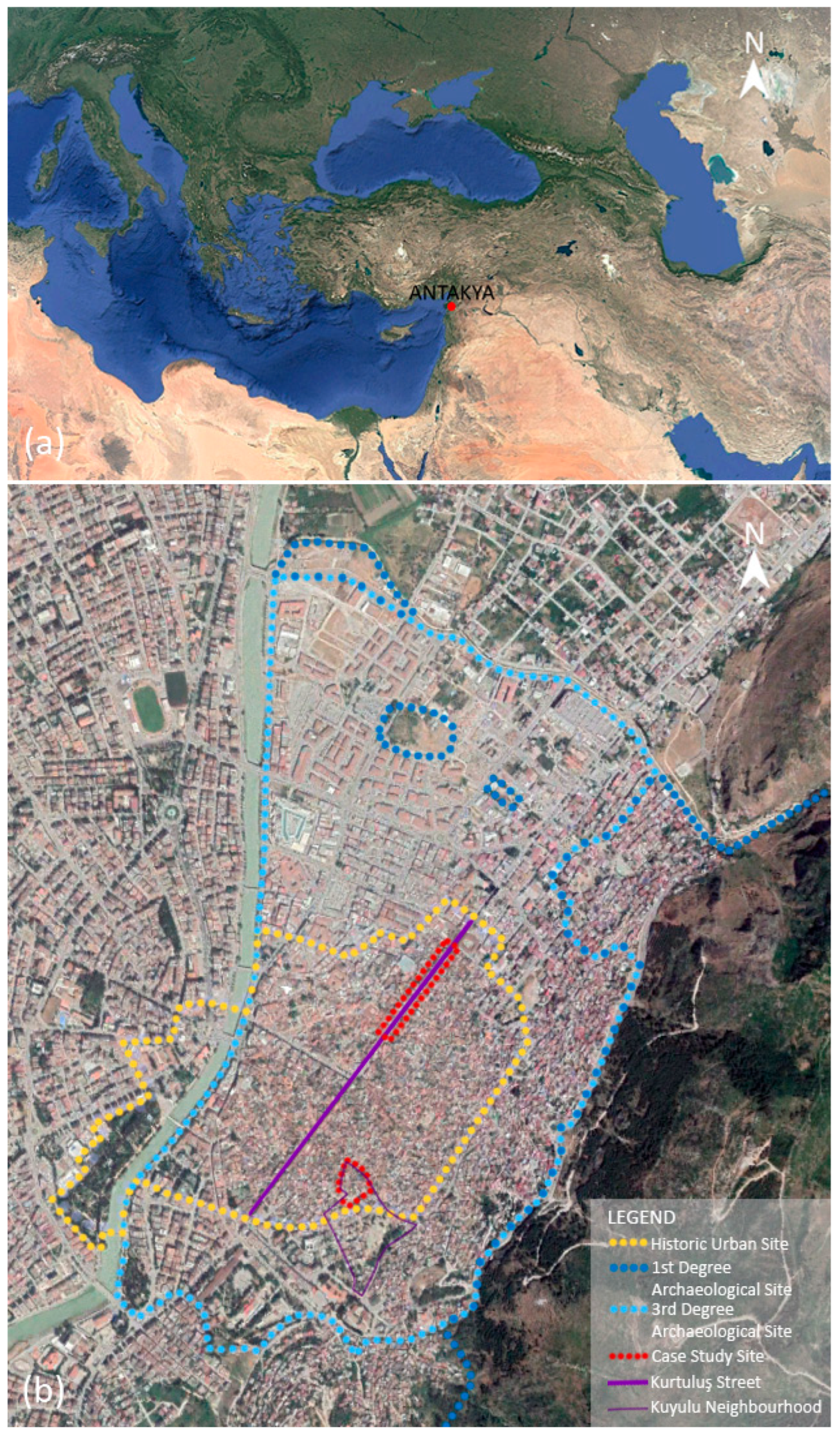
Figure 1. Location of Antakya in Türkiye (a), conservation sites and locations of case study sites in Antakya (source: (a) [31], (b) revised from [32]).
Architecture 05 00096 g001
Figure 2. Survey methodology of the study (source: IZTECH, 2019 [33]).
Architecture 05 00096 g002
Figure 3. Methodology diagram of the suggested value-based approach to guide interventions at historic urban sites after earthquake disasters.
Architecture 05 00096 g003
Figure 4. Geographical characteristics of Antakya (a), location of Asi River and Habib-i Neccar mountains, Kurtuluş Street and Kuyulu Neighborhood framed in red, and Habib-i Neccar Mosque as a landmark between case study sites framed in blue on the map (source: (a) [34], (b) revised from [32]).
Architecture 05 00096 g004
Figure 5. Building periods of the buildings on Kurtuluş Street and in Kuyulu Neighborhood (source: IZTECH, 2019 [33]).
Architecture 05 00096 g005
Figure 6. Road network morphology on Kurtuluş Street and in Kuyulu Neighborhood (source: IZTECH, 2019 [33]).
Architecture 05 00096 g006
Figure 7. Lot–building relationships on Kurtuluş Street and in Kuyulu Neighborhood (source: IZTECH, 2019 [33]).
Architecture 05 00096 g007
Figure 8. Figure–ground ratios in Kurtuluş Street and Kuyulu Neighborhood (source: IZTECH, 2019 [33]).
Architecture 05 00096 g008
Figure 9. Land use on Kurtuluş Street and in Kuyulu Neighborhood (source: IZTECH, 2019 [33]).
Architecture 05 00096 g009
Figure 10. Number of stories on Kurtuluş Street and in Kuyulu Neighborhood (source: IZTECH, 2019 [33]).
Architecture 05 00096 g010
Figure 11. Spatial characteristics on Kurtuluş Street and in Kuyulu Neighborhood (source: IZTECH, 2019 [33]).
Architecture 05 00096 g011
Figure 12. Authentic elements on Kurtuluş Street and in Kuyulu Neighborhood (source: IZTECH, 2019 [33]).
Architecture 05 00096 g012
Figure 13. Examples of “courtyard juxtaposed at one side by main mass” (source: IZTECH, 2019 [33]).
Architecture 05 00096 g013
Figure 14. Examples of “courtyard juxtaposed at its two opposing short sides by main masses” (source: IZTECH, 2019 [33]).
Architecture 05 00096 g014
Figure 15. Kurtuluş Street typology examples (source: IZTECH, 2019 [33]).
Architecture 05 00096 g015
Figure 16. Structural system types on Kurtuluş Street and in Kuyulu Neighborhood (source: IZTECH, 2019 [33]).
Architecture 05 00096 g016
Figure 17. Conservation conditions on Kurtuluş Street and in Kuyulu Neighborhood (source: IZTECH, 2019 [33]).
Architecture 05 00096 g017
Figure 18. Alterations on Kurtuluş Street and in Kuyulu Neighborhood (source: IZTECH, 2019 [33]).
Architecture 05 00096 g018
Figure 19. Value and problem examples on Kurtuluş Street and in Kuyulu Neighborhood (source: IZTECH, 2019 [33]).
Architecture 05 00096 g019
Figure 20. The only surviving French Period building in the examined portion of Kurtuluş Street before (a) and after the earthquake framed in red dashed line (b) (source: IZTECH 2019 [33] (a), revised from [38] 2023 (b)).
Architecture 05 00096 g020
Figure 21. State of Kurtuluş Street before (a) and after the earthquake (b), and of Kuyulu Neighborhood before (c) and after the earthquake (d) (source: revised from [32,39].).
Architecture 05 00096 g021
Table 1. Comparative analysis of conservation charters, guidelines, and standards.
Title of the DocumentIdentified Characteristics Giving Authenticity to a Heritage PlaceResilience Approach in Historic Urban LandscapesReconstruction Approach in Heritage SitesIs There an Attempt to Direct the Pre-Disaster Documentation Process or to Benefit From It to Guide Post-Disaster Interventions in Heritage Sites?
Washington Charter (ICOMOS, 1987) [1]Urban patterns (lots and streets), scale, size, style, construction, materials, color and decoration of buildings, functionsContinuous maintenance, compatible new functions and activities, careful improvement or installation of contemporary public facilitiesWhen it is necessary to construct new buildings or adapt existing ones, the existing spatial layout should be respected, especially in terms of scale and lot size.“Whatever the nature of a disaster affecting a historic town or urban area, preventative and repair measures must be adapted to the specific character of the properties concerned.”
The expression gives importance to the specific character of the site but does not exemplify/explain the documentation process to be used in a post-disaster case.
Nara Document (ICOMOS, 1994) [10]Particular forms and means of tangible and intangible expression rooted in cultures and societies: form and design, materials, use and function, traditions, setting, spirit and feeling---
Principles for the Analysis, Conservation and Structural Restoration of Architectural Heritage (ICOMOS, 2003) [11]The value of architectural heritage is not only in its appearance but also in the integrity of all its components as a unique product of the specific building technology of its time. In particular, the removal of the inner structures, maintaining only the façades, does not fit the conservation criteria.Regular maintenance, strengthening, and monitoring is suggested for heritage buildings.-“Safety evaluation and an understanding of the significance of the structure should be the basis for conservation and reinforcement measures.” Without mentioning disasters, the importance of understanding the significance is stated.
Xi’an Declaration (ICOMOS, 2005) [16]Beyond the physical and visual aspects, the setting includes interaction with the natural environment; past or present social or spiritual practices, customs, traditional knowledge, use, or activities; and other forms of intangible CH aspects that created and form the space, as well as the current and dynamic cultural, social, and economic context.Monitoring should prevent or remedy decay, loss of significance, or trivialization and propose improvement in conservation management. Cooperation and engagement with associated and local communities is essential as part of developing sustainable strategies for conservation.--
Quebec Declaration (ICOMOS, 2008) [15]The spirit of place is made up of tangible (sites, buildings, landscapes, routes, objects) as well as intangible elements (memories, narratives, written documents, festivals, commemorations, rituals, traditional knowledge, values, textures, colors, odors, etc.).The inhabitants and local authorities should be made aware of the safeguarding of the spirit of place so that they are better prepared to deal with the threats of a changing world.
Use of modern digital technologies (digital databases, websites) can be considered to document the spirit of place.
--
Lima Declaration (ICOMOS, 2010) [17]-Disaster mitigation and preparedness require a comprehensive assessment of risks to the site and its occupants and visitors. Detailed rescue and response plans should also be drawn up. In historic urban areas and living cultural landscapes and their settings, identifying, assessing, and monitoring disaster risks should be carried out in collaboration with local public, governmental, and non-governmental organizations.-“The local authorities often demolish historic fabric after a severe earthquake. However, all cultural remains must be conserved or restored by taking into account the principles of integrity and authenticity understood in the local context.”
This does not directly explain how to conserve authenticity and integrity but gives importance to it.
Valetta Principles (ICOMOS, 2011) [2]Urban patterns as defined by the street grid, the lots, the green spaces, and the relationships between buildings and green and open spaces; structure, volume, style, scale, materials, color, and decoration of buildings; functionsContinuous monitoring and maintenance are essential to safeguarding a historic town or urban area effectively.--
Recommendation on the Historic Urban Landscape (UNESCO, 2011) [5]The site’s topography, geomorphology, hydrology, and natural features; its built environment, both historic and contemporary; its infrastructures above and below ground; its open spaces and gardens; its land use patterns and spatial organization; perceptions and visual relationships; and all other elements of the urban structure, such as social and cultural practices and values, economic processes, and the intangible dimensions of heritage, are related to the diversity and identity of historic urban landscapes.The historic urban landscape approach may assist in managing and mitigating impacts of sudden disasters and armed conflicts by considering ecologically sensitive policies and practices aimed at strengthening sustainability and the quality of urban life.--
Burra Charter (ICOMOS, 2013) [13]Cultural significance (authenticity) means aesthetic, historic, scientific, social, or spiritual value for past, present, or future generations. Cultural significance is embodied in the place itself, its fabric, setting, use, associations, meanings, records, related places, and related objects.Maintenance should be undertaken where fabric is of cultural significance and its maintenance is necessary to retaining that cultural significance.The removed significant fabric should be reinstated when circumstances permit.
Reconstruction is appropriate only where a place is incomplete due to damage or alteration, and only where there is sufficient evidence to reproduce an earlier state of the fabric. In some cases, reconstruction may also be appropriate as part of a use or practice that retains the cultural significance of the place. Reconstruction should be identifiable on close inspection or through additional interpretation.
-
Conservation Principles, Policies and Guidance (Historic England 2008) [4]Fabric, evolution of place, identified valuesRegular monitoring should inform continual improvement of planned maintenance and identify the need for periodic repair or renewal at an early stage.-“Accessible records of the justification for decisions and the actions that follow them are crucial to maintaining a cumulative account of what has happened to a significant place, and understanding how and why its significance may have been altered.”
Do not express the disaster terminology, but emphasize the use of documentation records without explaining how to apply them.
Conservation of cultural property—Condition survey and report of built cultural heritage (European Standard (2012) [6]-Maintenance: Preventive measures and simple repair can be recommended by using this standard. Other interventions cannot be recommended based on this condition survey alone.--
Sendai Framework for Disaster Risk Reduction 2015–2030 (2015) [19]-Resilience is ensured by understanding disaster risk, strengthening disaster risk governance to manage disaster risk, investing in disaster risk reduction for resilience, and enhancing disaster preparedness for effective response and to “Build Back Better” in recovery, rehabilitation, and reconstruction.In the post-disaster recovery, rehabilitation, and reconstruction phase, it is critical to prevent the creation of disaster risk and to reduce disaster risk by “Building Back Better” and increasing public education and awareness of disaster risk.Understanding disaster risk is possible due to the collection, analysis, management, and use of relevant data.
Guidance on Post-Trauma Recovery and Reconstruction for World Heritage Cultural Properties (ICOMOS, 2017) [7]Outstanding Universal Value (OUV) in world heritage sites shows the authenticity. Components of OUV: form and design; materials and substance; use and function; traditions, techniques, and management systems; location and setting; language and other forms of intangible heritage; spirit and feeling; and beliefs, stories, festivals, and ritualsDestruction impacting urban fabric may offer the opportunity to remediate problematic situations, improve living conditions, and/or improve the setting of what has survived. Articulating an approach for rebuilding urban areas requires recovering and sustaining OUV.Reconstruction as a critical element to the maintenance of customary knowledge, practices, and beliefs, or as an opportunity to sustain these or other intangible attributes: supporting the capacity of affected communities to maintain their cultural space, activities, and values in the context of changed circumstances“While the existence of documentation prior to disaster is fundamental for comparison, the importance of early recording of damage and surviving elements is emphasized. The priority for documentation is established on the basis of historic records and the attributes of OUV, or on the more obvious and iconic attributes, internationally or locally referred to, and how they are manifested. Image capture (such as photographs, aerial views, etc.) is a first essential step; other forms of documentation such as audio recording must be utilized as circumstances allow.” While after-disaster documentation is emphasized, the pre-disaster documentation and benefiting from it is not considered.
Culture in City Reconstruction (UNESCO 2018) [8]Admits the authenticity identification of the HUL Recommendation and finds it beneficial for balanced value-giving to natural and man-made components of heritage sitesResilience rooted in community involvement in the reconstruction process and guiding the continuity of traditions is aimed for.Reconstruction is defined as the medium- and long-term rebuilding and sustainable restoration of resilient infrastructure, services, housing, facilities, and livelihoods required for the full functioning of a community or a society affected by a disaster.Not the pre-disaster documentation, but the communities’ memories, containing the living record of heritage sites, are considered the key source of directing post-disaster interventions to enliven spaces related to traditions, daily life, and rituals.
Post-Disaster and Post-Conflict
Recovery and Reconstruction
for
Heritage Places of Cultural
Significance and World
Heritage Cultural Properties (ICOMOS and ICCROM 2023) [9]
-“Build Back Better” in the heritage context includes ensuring that the issues that led to or contributed to the loss of a heritage place in a disaster (such as poor maintenance, poor drainage, inappropriate structural interventions, inappropriate use and/or abandonment, inoperative management plans) are addressed in the recovery.Reconstruction is one of the strategies that may be adopted to maintain or restore the physical environment during the recovery process. Achieving this will involve the maximum retention of surviving material and, in certain circumstances, may involve adding new material where necessary to maintain or recover significance.Does not focus on pre-disaster documentation but emphasizes in-detail post-disaster documentation on sites to guide interventions
Table 2. Authenticity parameters in conservation charters, guidelines, and standards, and the determined analysis themes.
Authenticity Parameters in Conservation Charters, Guidelines, and StandardsAnalysis Themes Based on Authenticity Parameters
Urban patterns (lots and streets), scale, size (Washington Charter, 1987) [1]
Form and design, setting (Nara Document, 1994) [10]
Sites, buildings, landscapes (Quebec Declaration, 2008) [12]
Urban patterns as defined by the street grid, the lots, the green spaces, and the relationships between buildings and green and open spaces, volume, and scale (Valetta Principles, 2011) [2]
Fabric, setting (Burra Charter, 2013) [13]
Fabric (Historic England, 2008) [4]
Form and design, location and setting (Guidance on Post-Trauma Recovery and Reconstruction for World Heritage Cultural Properties, 2017) [7]
Road network morphology
Lot-building relationships
Figure–ground
Number of stories
Style (Washington Charter, 1987; Valetta Principles, 2011) [1,2]
Evolution of place (Historic England, 2008) [4]
Building periods
Functions (Washington Charter, 1987; Valetta Principles, 2011) [1,2]
Use or activities (Xi’an Declaration, 2005) [16]
Land use patterns (HUL, 2011) [5]
Use (Burra Charter, 2013) [13]
Use and function (Nara Document, 2004; Guidance on Post-Trauma Recovery and Reconstruction for World Heritage Cultural Properties, 2017) [7,10]
Land use
Built environment, its open spaces and gardens, spatial organization (HUL, 2011) [5]Spatial characteristics
Housing unit typologies
Decoration of buildings (Washington Charter, 1987; Valetta Principles, 2011) [1,2]
Traditions, spirit, and feeling (Nara Document, 2004) [10]
Past or present social or spiritual practices, customs, traditional knowledge (Xi’an Declaration, 2005) [14]
Social and cultural practices (HUL, 2011) [5]
Rituals, traditional knowledge (Quebec Declaration, 2008) [12]
Associations, meanings, records (Burra Charter, 2013) [13]
Traditions, spirit and feeling, beliefs, stories, festivals, rituals (Guidance on Post-Trauma Recovery and Reconstruction for World Heritage Cultural Properties, 2017) [7]
Authentic elements
Socio-cultural aspects
Construction, materials (Washington Charter, 1987) [1]
Materials (Nara Document, 2004) [10]
Building technology (Principles for the Analysis, Conservation and Structural Restoration of Architectural Heritage, 2003) [11]
Structure, materials (Valetta Principles, 2011) [2]
Materials and substance (Guidance on Post-Trauma Recovery and Reconstruction for World Heritage Cultural Properties, 2017) [7]
Structural system types
7. Continuing maintenance is crucial to the effective conservation of a historic town or urban area (Washington Charter, 1987) [1].
Knowledge and understanding of the material evidence of built cultural heritage and the information on its current state is important as it helps to specify measures necessary to preserve structures in an appropriate condition and ensure that the maintenance required to keep them at this level is well defined. Preventive conservation, regular condition surveys, and maintenance is the best way to conserve and maintain the significance of built cultural heritage while ensuring that its authenticity and integrity are retained (Conservation of cultural property—Condition survey and report of built cultural heritage, European Standard, 2012) [6]
Article 16. Maintenance is fundamental to conservation. Maintenance should be undertaken where fabric is of cultural significance and its maintenance is necessary to retain that cultural significance (Burra Charter, 2013) [13]
Conservation conditions
The basis of appropriate architectural interventions in spatial, visual, intangible, and functional terms should be respected for historical values, patterns, and layers (Valetta Principles, 2011) [2].
Article 3. Cautious approach: The traces of additions, alterations, and earlier treatments to the fabric of a place are evidence of its history and uses, which may be part of its significance. Conservation action should assist and not impede their understanding (Burra Charter, 2013) [13].
27.2 Existing fabric, use, associations, and meanings should be adequately recorded before and after any changes are made to the place (Burra Charter, 2013) [13].
Alterations
Disclaimer/Publisher’s Note: The statements, opinions and data contained in all publications are solely those of the individual author(s) and contributor(s) and not of MDPI and/or the editor(s). MDPI and/or the editor(s) disclaim responsibility for any injury to people or property resulting from any ideas, methods, instructions or products referred to in the content.