Bridging Spectral Statistics and Machine Learning for Semantic Road Network Analysis


Abstract
1. Introduction
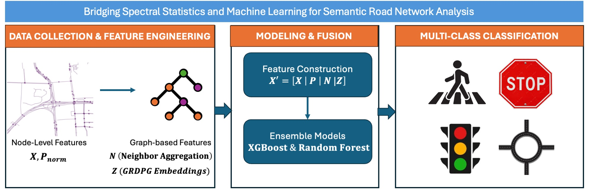
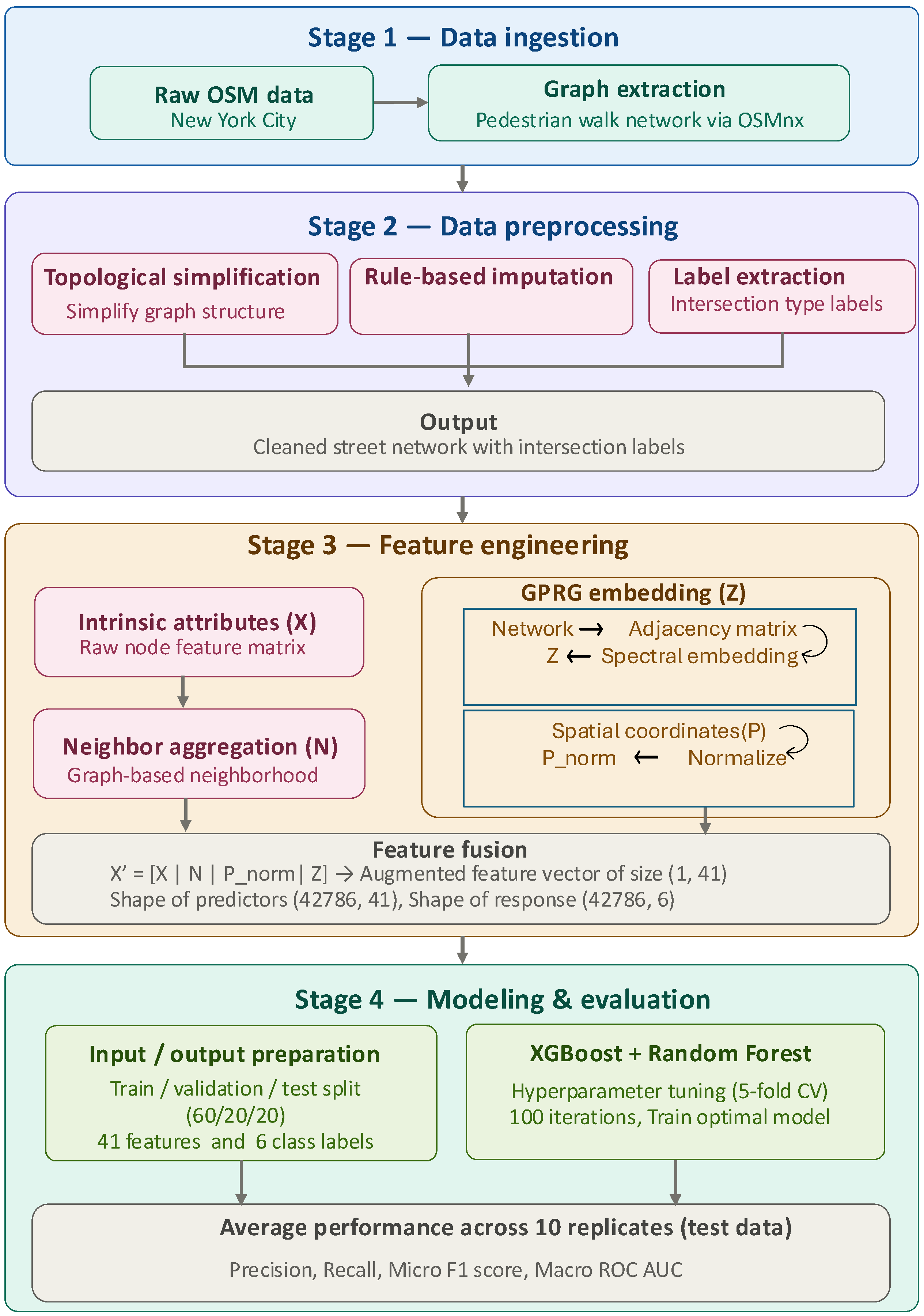
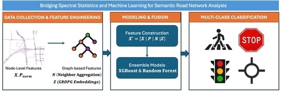
- Framework for Topological Augmentation: We propose a highly efficient, hybrid classification framework that seamlessly augments intrinsic node attributes with GRDPG spatial embeddings and neighbor-aggregated features. These augmented features are then processed utilizing robust, tree-based ensemble classifiers (Random Forest and XGBoost).
- Handling Network Heterophily: We demonstrate that our augmented topological features effectively capture the disassortative mixing (heterophily) inherent in urban road networks. This provides the essential structural context needed to differentiate structurally dissimilar, yet physically connected, intersection nodes.
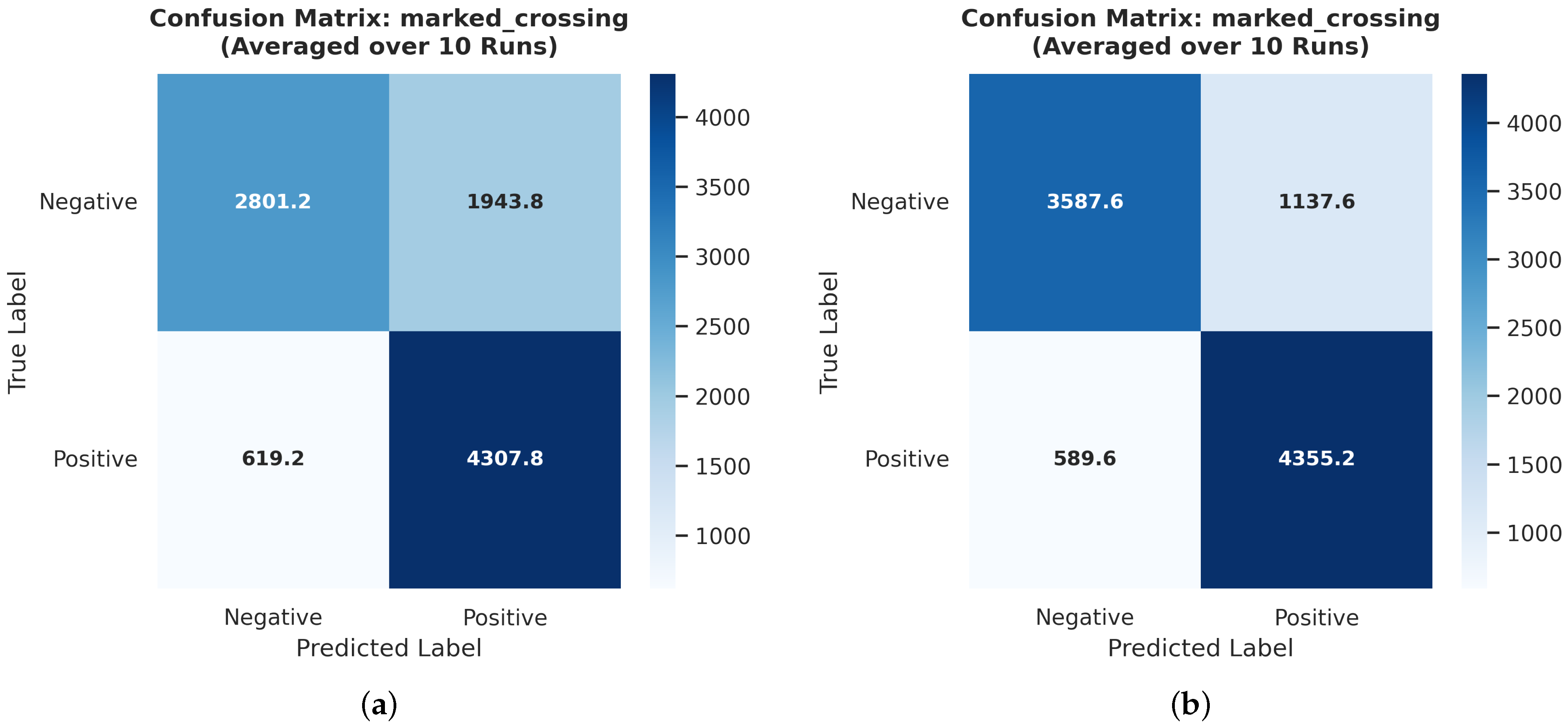
- Empirical Validation on Urban Data: Utilizing a massive dataset of over 48,000 intersections across New York City, we empirically prove that topological context is the definitive discriminator for identifying urban infrastructure. Our augmented XGBoost model achieves a relative improvement in F1 score over the baseline model for the highly challenging marked_crossing class.
2. Related Work
3. Methodology
3.1. Problem Formulation
3.2. Data Collection and Preparation
3.2.1. Graph Extraction
3.2.2. Feature Engineering
- Node degree: number of neighboring intersections directly connected to the node.
- Clustering coefficient: local clustering coefficient computed from the intersection graph, measuring the connectivity among neighboring intersections.
- Number of incident edges: total number of road segments meeting at the intersection.
- Mean number of lanes: average value of the OSM lanes tag across all incident road segments.
- Maximum number of lanes: maximum value of the lanes tag across incident road segments.
- Mean speed limit: average value of the OSM maxspeed tag across incident road segments.
- Maximum speed limit: maximum value of the maxspeed tag across incident road segments.
3.2.3. Label Generation
- signalized: Traffic signal presence.
- marked_crossing: Presence of marked pedestrian crossings.
- crossing_signalized: Crossing specifically controlled by a signal.
- crossing_marked: Marked crossing without necessary signalization.
- crossing_unmarked: Pedestrian crossing point without markings.
- stop_any: Stop sign controlling any approach.
3.3. Exploratory Data Analysis
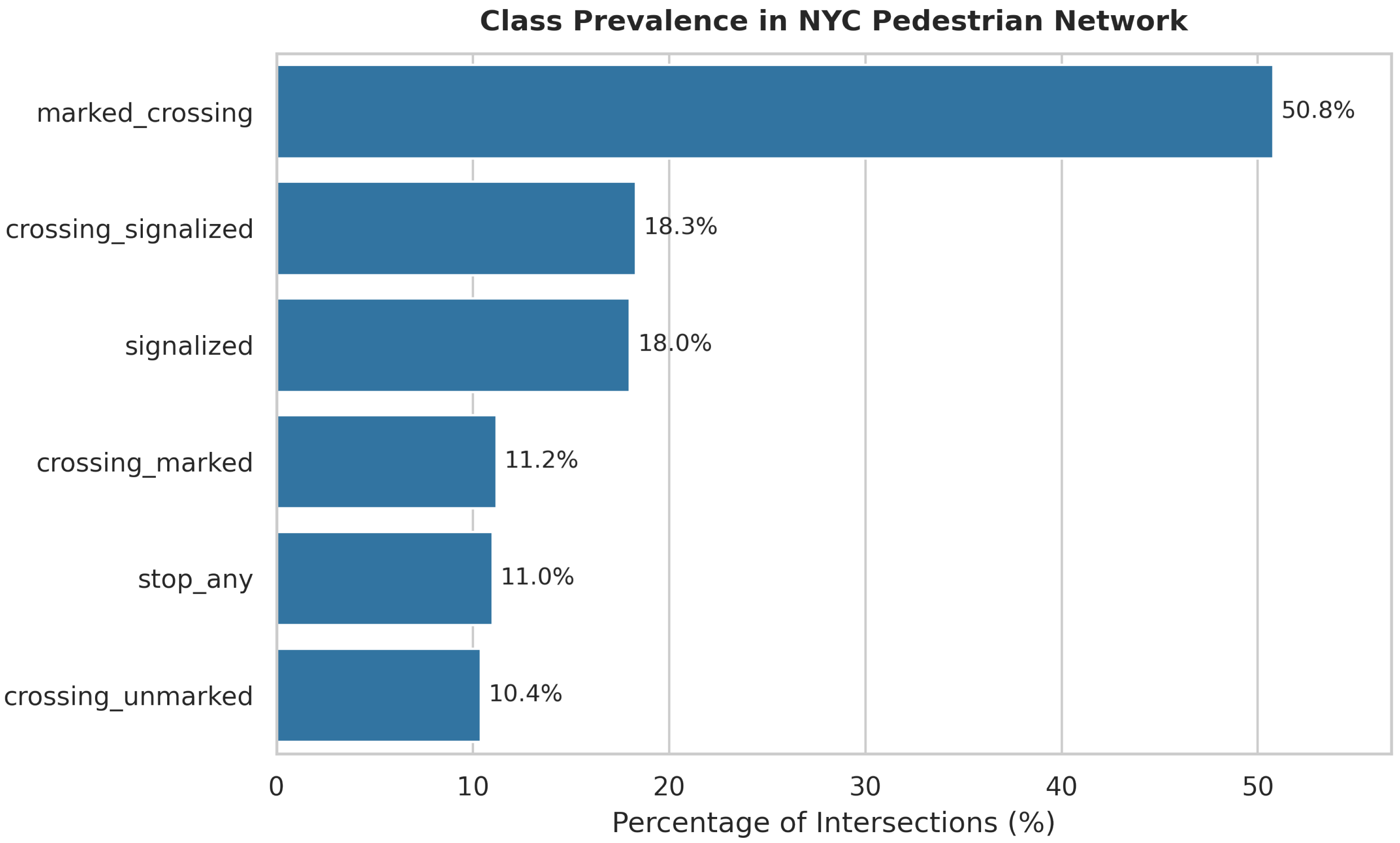
- Label Prevalence: The dataset exhibits significant class imbalance (Figure 2), with marked_crossing appearing in 50.8% of intersections.
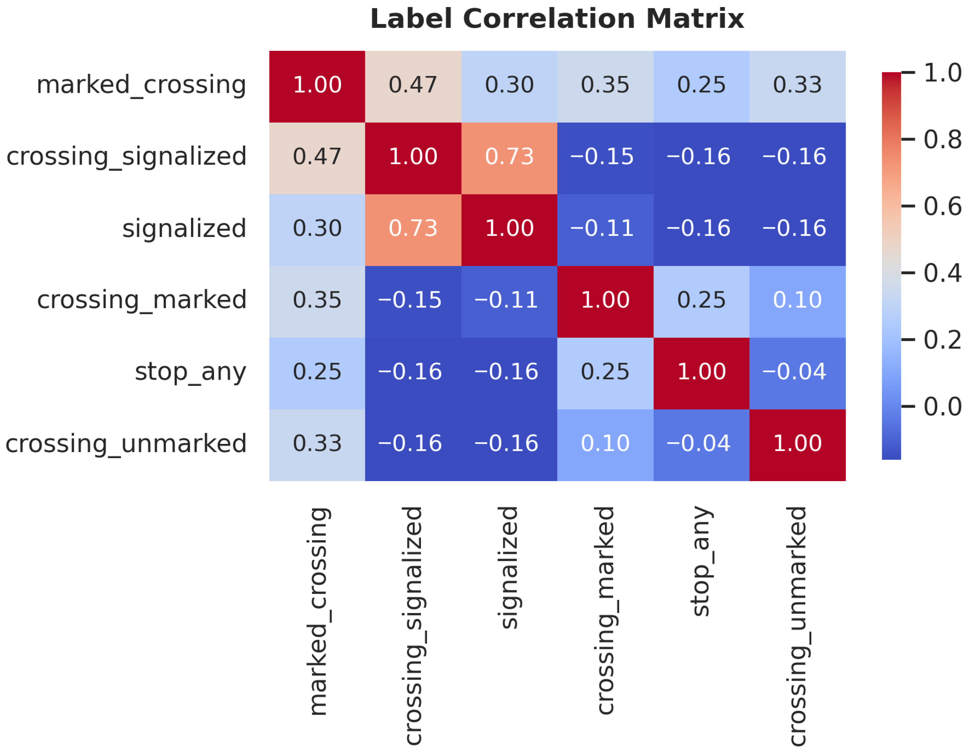
- Label Correlation: Figure 3 shows the Pearson correlation between labels. A strong positive correlation exists between signalized and crossing_signalized, indicating that traffic signals and signalized pedestrian crosswalks typically co-occur.
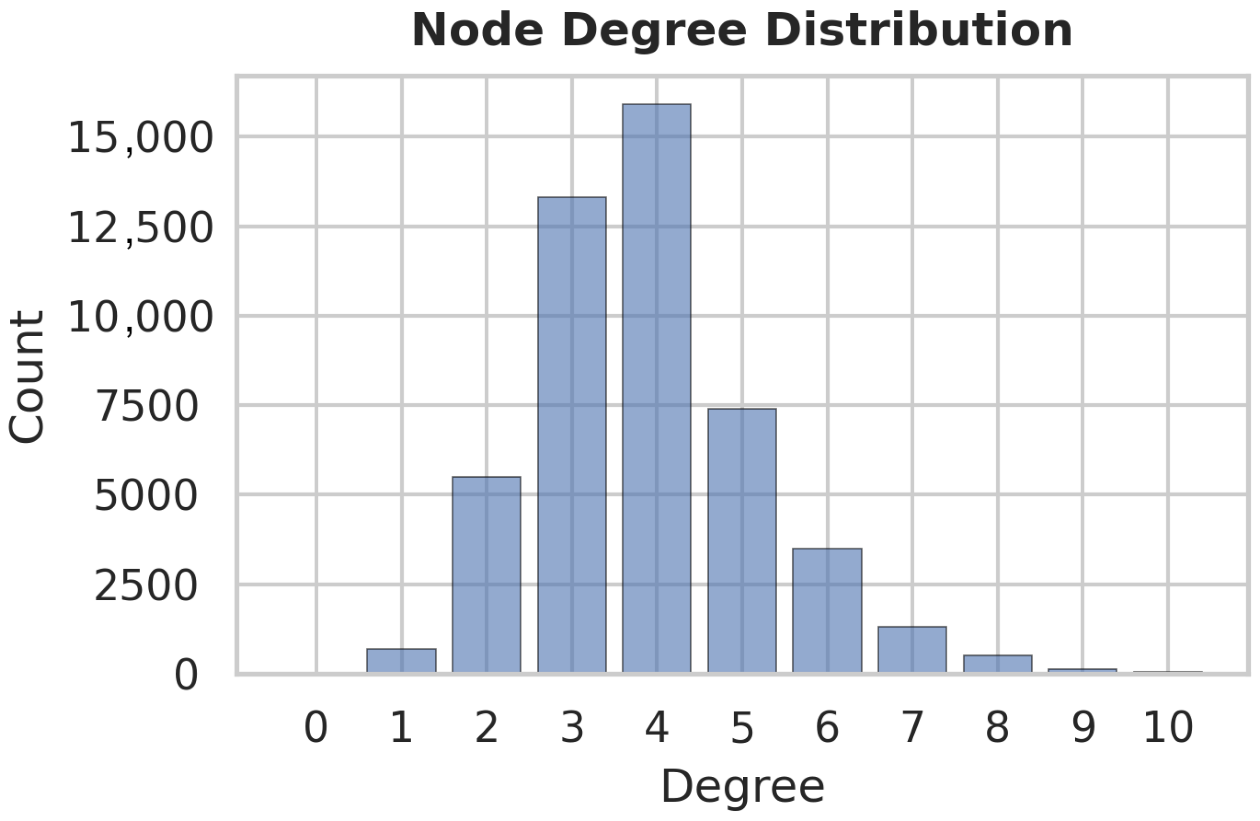
- Network Topology: The node degree distribution (Figure 4) is bimodal, peaking at (standard cross-streets, ≈16,000 nodes) and (T-intersections, ≈13,500 nodes). This structural regularity supports the use of spectral embedding methods to capture local neighborhood geometry.
3.4. Structural Feature Extraction with GRDPG and Feature Augmentation
3.5. Classification Models & Statistical Validation
3.5.1. Model Configurations
3.5.2. Validation Protocol
4. Results
4.1. Comparative Analysis
4.2. Class-Specific Performance Gains
4.3. Visualizing Model Performances
4.4. Feature Importance
5. Discussion
5.1. The Value of Topological Context
5.2. Model Suitability and Generalization
5.3. Limitations
6. Conclusions and Future Work
Author Contributions
Funding
Data Availability Statement
Conflicts of Interest
References
- Haklay, M. How good is volunteered geographical information? A comparative study of OpenStreetMap and Ordnance Survey datasets. Environ. Plan. B Plan. Des. 2010, 37, 682–703. [Google Scholar] [CrossRef] [Scilit]
- Barrington-Leigh, C.; Millard-Ball, A. The world’s user-generated road map is more than 80% complete. PLoS ONE 2017, 12, e0180698. [Google Scholar] [CrossRef] [Scilit]
- Moradi, M.; Roche, S.; Abolfazl Mostafavi, M. Exploring Five Indicators for the Quality of OSM Road Network: A Case Study of Qubec, Canada. Geomatica 2021, 75, 1–55. [Google Scholar] [CrossRef] [Scilit]
- Hosseini, R.; Tong, D.; Lim, S.; Sohn, G.; Gidófalvi, G. A framework for performance analysis of OpenStreetMap data in navigation applications: The case of a well-developed road network in Australia. Ann. GIS 2025, 31, 233–250. [Google Scholar] [CrossRef] [Scilit]
- Deri, F.; Mara, F.; Anselmi, C. Crowdsourced Data for Urban Planning: A Critical Evaluation of OpenStreetMap Accuracy and Completeness. In Proceedings of the International Conference on Computational Science and Its Applications; Springer: Berlin/Heidelberg, Germany, 2025; pp. 403–420. [Google Scholar]
- Han, C.; Lu, B.; Zheng, J.; Yu, D.; Zheng, S. Research on multiscale OpenStreetMap in China: Data quality assessment with EWM-TOPSIS and GDP modeling. Geo-Spat. Inf. Sci. 2025, 28, 1316–1340. [Google Scholar] [CrossRef] [Scilit]
- Borkowska, S.; Pokonieczny, K. Analysis of OpenStreetMap data quality for selected counties in Poland in terms of sustainable development. Sustainability 2022, 14, 3728. [Google Scholar] [CrossRef] [Scilit]
- Rubin-Delanchy, P.; Priebe, C.; Tang, M. The generalised random dot product graph. arXiv 2017, arXiv:1709.05506. [Google Scholar]
- Athreya, A.; Fishkind, D.E.; Tang, M.; Priebe, C.E.; Park, Y.; Vogelstein, J.T.; Levin, K.; Lyzinski, V.; Qin, Y.; Sussman, D.L. Statistical inference on random dot product graphs: A survey. J. Mach. Learn. Res. 2018, 18, 1–92. [Google Scholar]
- Rubin-Delanchy, P.; Cape, J.; Tang, M.; Priebe, C.E. A statistical interpretation of spectral embedding: The generalised random dot product graph. J. R. Stat. Soc. Ser. B Stat. Methodol. 2022, 84, 1446–1473. [Google Scholar] [CrossRef] [Scilit]
- Crucitti, P.; Latora, V.; Porta, S. Centrality in networks of urban streets. Chaos Interdiscip. J. Nonlinear Sci. 2006, 16, 015113. [Google Scholar] [CrossRef] [Scilit]
- Crucitti, P.; Latora, V.; Porta, S. Centrality measures in spatial networks of urban streets. Phys. Rev. E—Stat. Nonlinear Soft Matter Phys. 2006, 73, 036125. [Google Scholar] [CrossRef] [Scilit]
- Porta, S.; Crucitti, P.; Latora, V. The network analysis of urban streets: A dual approach. Phys. A Stat. Mech. Its Appl. 2006, 369, 853–866. [Google Scholar] [CrossRef] [Scilit]
- Barthelemy, M.; Boeing, G. A review of the structure of street networks. arXiv 2024, arXiv:2409.08016. [Google Scholar] [CrossRef] [Scilit]
- Yadav, N.; Chatterjee, S.; Ganguly, A.R. Resilience of urban transport network-of-networks under intense flood hazards exacerbated by targeted attacks. Sci. Rep. 2020, 10, 10350. [Google Scholar] [CrossRef] [Scilit]
- Xu, Z.; Chopra, S.S. Interconnectedness enhances network resilience of multimodal public transportation systems for Safe-to-Fail urban mobility. Nat. Commun. 2023, 14, 4291. [Google Scholar] [CrossRef] [Scilit]
- Kim, S.; Yeo, H. A flow-based vulnerability measure for the resilience of urban road network. Procedia-Soc. Behav. Sci. 2016, 218, 13–23. [Google Scholar] [CrossRef] [Scilit]
- Li, Z.; Yan, W.; Wang, L. Measuring mobility resilience with network-based simulations of flow dynamics under extreme events. Transp. Res. Part D Transp. Environ. 2024, 135, 104362. [Google Scholar] [CrossRef] [Scilit]
- Tao, R.; Xi, Y.; Li, D. Simulation analysis on urban traffic congestion propagation based on complex network. In Proceedings of the 2016 IEEE International Conference on Service Operations and Logistics, and Informatics (SOLI); IEEE: New York, NY, USA, 2016; pp. 217–222. [Google Scholar]
- Ding, R.; Ujang, N.; Hamid, H.B.; Manan, M.S.A.; Li, R.; Albadareen, S.S.M.; Nochian, A.; Wu, J. Application of complex networks theory in urban traffic network researches. Netw. Spat. Econ. 2019, 19, 1281–1317. [Google Scholar] [CrossRef] [Scilit]
- Osorio, C.; Bierlaire, M. A simulation optimization framework for the management of congested urban road networks. In Proceedings of the Seventh Swiss Transport Research Conference (STRC), Ascona, Switzerland, 9–11 September 2009. [Google Scholar]
- Hu, W.; Wang, H.; Qiu, Z.; Yan, L.; Nie, C.; Du, B. An urban traffic simulation model for traffic congestion predicting and avoiding. Neural Comput. Appl. 2018, 30, 1769–1781. [Google Scholar] [CrossRef] [Scilit]
- Liu, Y.; Guo, Q.; Zheng, C. Urban street network morphology classification through street-block based graph neural networks and multi-model fusion. Int. J. Digit. Earth 2025, 18, 2497490. [Google Scholar] [CrossRef] [Scilit]
- Tang, S.; Randhawa, S.; Rui, J.; Ludwig, C.; Knoblauch, S.; Hatfield, C.; Zipf, A. Estimating road speed classes: Integrating OpenStreetMap and Street View imagery for missing data imputation. Comput. Environ. Urban Syst. 2026, 125, 102392. [Google Scholar] [CrossRef] [Scilit]
- Vargas-Munoz, J.E.; Srivastava, S.; Tuia, D.; Falcao, A.X. OpenStreetMap: Challenges and opportunities in machine learning and remote sensing. IEEE Geosci. Remote Sens. Mag. 2020, 9, 184–199. [Google Scholar] [CrossRef] [Scilit]
- Zurbaran, M.; Wightman, P.; Brovelli, M.A. A machine learning pipeline articulating satellite imagery and openstreetmap for road detection. Int. Arch. Photogramm. Remote Sens. Spat. Inf. Sci. 2019, 42, 255–260. [Google Scholar] [CrossRef] [Scilit]
- Parvathi, R.; Pattabiraman, V.; Saxena, N.; Mishra, A.; Mishra, U.; Pandey, A. Automated road surface classification in OpenStreetMap using MaskCNN and aerial imagery. Front. Big Data 2025, 8, 1657320. [Google Scholar] [CrossRef] [Scilit]
- Hacar, M.; Altafini, D.; Cutini, V. Network-based hierarchical feature augmentation for predicting road classes in OpenStreetMap. ISPRS Int. J. Geo-Inf. 2024, 13, 456. [Google Scholar] [CrossRef] [Scilit]
- Neira, M.; Murcio, R. Graph representation learning on street networks. ISPRS Int. J. Geo-Inf. 2025, 14, 284. [Google Scholar] [CrossRef] [Scilit]
- He, S.; Bastani, F.; Jagwani, S.; Park, E.; Abbar, S.; Alizadeh, M.; Balakrishnan, H.; Chawla, S.; Madden, S.; Sadeghi, M.A. Roadtagger: Robust road attribute inference with graph neural networks. In Proceedings of the AAAI Conference on Artificial Intelligence, New York, NY, USA, 7–12 February 2020; Volume 34, pp. 10965–10972. [Google Scholar]
- Holland, P.W.; Laskey, K.B.; Leinhardt, S. Stochastic blockmodels: First steps. Soc. Netw. 1983, 5, 109–137. [Google Scholar] [CrossRef] [Scilit]
- Young, S.J.; Scheinerman, E.R. Random dot product graph models for social networks. In Proceedings of the International Workshop on Algorithms and Models for the Web-Graph; Springer: Berlin/Heidelberg, Germany, 2007; pp. 138–149. [Google Scholar]
- Priebe, C.E.; Park, Y.; Tang, M.; Athreya, A.; Lyzinski, V.; Vogelstein, J.T.; Qin, Y.; Cocanougher, B.; Eichler, K.; Zlatic, M.; et al. Semiparametric spectral modeling of the Drosophila connectome. arXiv 2017, arXiv:1705.03297. [Google Scholar] [CrossRef] [Scilit]
- Yuan, C.; Zhao, K.; Kuruoglu, E.E.; Wang, L.; Xu, T.; Huang, W.; Zhao, D.; Cheng, H.; Rong, Y. A survey of graph transformers: Architectures, theories and applications. arXiv 2025, arXiv:2502.16533. [Google Scholar] [CrossRef] [Scilit]
- Boeing, G. OSMnx: New methods for acquiring, constructing, analyzing, and visualizing complex street networks. Comput. Environ. Urban Syst. 2017, 65, 126–139. [Google Scholar] [CrossRef] [Scilit]
- Badran, A.; El-Geneidy, A.; Miranda-Moreno, L. Inferring Road Intersection Control Type from GPS Data. 2022. Available online: https://findingspress.org/article/37715-inferring-road-intersection-control-type-from-gps-data (accessed on 24 March 2026).
- Caruana, R.; Niculescu-Mizil, A. An empirical comparison of supervised learning algorithms. In Proceedings of the 23rd International Conference on Machine Learning, Pittsburgh, PA, USA, 25–29 June 2006; pp. 161–168. [Google Scholar]
- Sun, Z.M.; Ren, G.; Hu, Y.X.; Lin, H. Improved traffic flow estimation based on integrated learning methods. In Proceedings of the Eighth International Conference on Electromechanical Control Technology and Transportation (ICECTT 2023); SPIE: Bellingham, WA, USA, 2023; Volume 12790, pp. 500–507. [Google Scholar]
- Breiman, L. Random forests. Mach. Learn. 2001, 45, 5–32. [Google Scholar] [CrossRef] [Scilit]
- Chen, T. XGBoost: A Scalable Tree Boosting System; Cornell University: Ithaca, NY, USA, 2016. [Google Scholar]




| Model | Precision | Recall | Micro F1 Score | Macro ROC AUC |
|---|---|---|---|---|
| XGBoost (Baseline) | 0.5210 | 0.6845 | ||
| XGBoost (Augmented) | 0.6558 | 0.7520 | ||
| Random Forest (Baseline) | 0.6002 | 0.7095 | ||
| Random Forest (Augmented) | 0.6036 | 0.7177 |
| Class Label | Baseline F1 | Augmented F1 | Relative Improvement |
|---|---|---|---|
| marked_crossing | 0.3371 | 0.5794 | +71.88% |
| crossing_unmarked | 0.3352 | 0.4831 | +44.12% |
| stop_any | 0.3921 | 0.4889 | +24.6% |
| signalized | 0.5858 | 0.6840 | +16.76% |
| crossing_signalized | 0.5622 | 0.6783 | +20.65% |
| Random Forest | XGBoost | |||
|---|---|---|---|---|
| Rank | Feature | Imp. | Feature | Imp. |
| 1 | Coord X (Latitude) | 0.313 | Incident Edges | 0.243 |
| 2 | Coord Y (Longitude) | 0.276 | Degree | 0.170 |
| 3 | Incident Edges | 0.192 | Lanes (Max) | 0.125 |
| 4 | Degree | 0.069 | Coord X (Latitude) | 0.101 |
| 5 | Clustering Coefficient | 0.065 | Clustering Coefficient | 0.097 |
| 6 | Lanes (Mean) | 0.032 | Coord Y (Longitude) | 0.076 |
| 7 | Lanes (Max) | 0.029 | Max Speed (Mean) | 0.063 |
| 8 | Max Speed (Mean) | 0.013 | Max Speed (Max) | 0.062 |
| 9 | Max Speed (Max) | 0.011 | Lanes (Mean) | 0.062 |
| Random Forest (MDI) | XGBoost (Gain) | |||
|---|---|---|---|---|
| Rank | Feature | Imp. | Feature | Imp. |
| 1 | Neighbor Speed (Mean) | 0.2620 | Incident Edges | 0.0931 |
| 2 | Neighbor Speed (Max) | 0.2221 | Lanes (Max) | 0.0801 |
| 3 | Incident Edges | 0.1712 | Degree | 0.0781 |
| 4 | Degree | 0.0598 | Lanes (Mean) | 0.0761 |
| 5 | Clustering Coefficient | 0.0551 | Max Speed (Mean) | 0.0536 |
| 6 | Lanes (Mean) | 0.0282 | Max Speed (Max) | 0.0389 |
| 7 | Lanes (Max) | 0.0252 | Clustering Coefficient | 0.0329 |
| 8 | Neighbor Lanes (Max) | 0.0172 | Coord Y (Longitude) | 0.0322 |
| 9 | Max Speed (Mean) | 0.0094 | Coord X (Latitude) | 0.0204 |
| 10 | GRDPG Dim 17 | 0.0090 | Neighbor Incident Edges | 0.0194 |
| 11 | GRDPG Dim 20 | 0.0079 | GRDPG Dim 17 | 0.0169 |
| 12 | Max Speed (Max) | 0.0079 | Neighbor Clustering | 0.0155 |
| 13 | Neighbor Clustering | 0.0077 | Neighbor Speed (Max) | 0.0148 |
| 14 | GRDPG Dim 14 | 0.0075 | GRDPG Dim 26 | 0.0141 |
| 15 | GRDPG Dim 24 | 0.0071 | Neighbor Lanes (Mean) | 0.0137 |
Disclaimer/Publisher’s Note: The statements, opinions and data contained in all publications are solely those of the individual author(s) and contributor(s) and not of MDPI and/or the editor(s). MDPI and/or the editor(s) disclaim responsibility for any injury to people or property resulting from any ideas, methods, instructions or products referred to in the content. |
© 2026 by the authors. Licensee MDPI, Basel, Switzerland. This article is an open access article distributed under the terms and conditions of the Creative Commons Attribution (CC BY) license.
Share and Cite
Kelly, A.; Rimal, R.; Sainju, A.M. Bridging Spectral Statistics and Machine Learning for Semantic Road Network Analysis. Geomatics 2026, 6, 35. https://doi.org/10.3390/geomatics6020035
Kelly A, Rimal R, Sainju AM. Bridging Spectral Statistics and Machine Learning for Semantic Road Network Analysis. Geomatics. 2026; 6(2):35. https://doi.org/10.3390/geomatics6020035
Chicago/Turabian StyleKelly, Abigail, Ramchandra Rimal, and Arpan Man Sainju. 2026. "Bridging Spectral Statistics and Machine Learning for Semantic Road Network Analysis" Geomatics 6, no. 2: 35. https://doi.org/10.3390/geomatics6020035
APA StyleKelly, A., Rimal, R., & Sainju, A. M. (2026). Bridging Spectral Statistics and Machine Learning for Semantic Road Network Analysis. Geomatics, 6(2), 35. https://doi.org/10.3390/geomatics6020035