Article

Evaluating Neural Radiance Fields for Image-Based 3D Reconstruction: A Comparative Study with SfM-MVS

by
Alessia Giaquinto
,
Giampaolo Ferraioli
and
Silvio Del Pizzo
*
Department of Sciences and Technologies, Università Degli Studi di Napoli “Parthenope”, 80133 Naples, Italy
*
Author to whom correspondence should be addressed.
Geomatics 2026, 6(1), 4; https://doi.org/10.3390/geomatics6010004
Submission received: 8 August 2025 / Revised: 24 November 2025 / Accepted: 8 January 2026 / Published: 10 January 2026

Abstract

Recent advances in image-based 3D reconstruction have seen a shift from traditional photogrammetric techniques to learning-based methods, with Neural Radiance Fields (NeRFs) emerging as a powerful alternative. This study evaluates NeRF (via Nerfstudio) for accurate 3D reconstruction, comparing its performance to the widely used SfM-MVS pipeline implemented in Agisoft Metashape Professional (v. 2.2.1). This work considers a diverse set of datasets with varying object scales, capture methods (including drone imagery), and lighting conditions. Several assessment analyses were conducted, including evaluation of accuracy, completeness, planarity, and density of the reconstructed point clouds. Special attention was given to the influence of shadows and surface flatness on the fidelity of reconstruction. Results show that, despite not being initially designed for metric accuracy, NeRF demonstrates promising spatial consistency, producing reconstructions in some cases comparable to those of conventional methods when provided with precise camera poses. These findings suggest that NeRF may serve as a viable tool for 3D modelling in controlled settings. The applicability of the approach to more diverse and challenging scenarios remains to be explored, with particular attention to optimizing the reconstruction pipeline in terms of pose estimation, point cloud density, and robustness to varying lighting conditions.

1. Introduction

In recent years, 3D reconstruction from images has played an increasingly central role in various fields, such as photogrammetry, virtual and augmented reality, architectural modelling, medicine, etc. [1,2,3,4,5]. The creation of precise and detailed 3D models of objects and environments has become essential for many applications, driving the continuous development of the techniques used.
For a long time, traditional 3D reconstruction methods dominated the technological field. These approaches, based on photogrammetric and geometric principles, use images and spatial measurements to construct three-dimensional models. Among these methods, the Structure from Motion (SfM) and Multi-View Stereo (MVS) algorithms have assumed an increasingly significant role. The former is a computer vision technique that enables the reconstruction of a three-dimensional representation of a scene from two-dimensional images. SfM leverages the principle of parallax by analysing how the characteristic points of an object or scene shift across different images taken from varying angles or positions.
MVS algorithms, on the other hand, focus on reconstructing a detailed three-dimensional representation of a scene using multiple images captured from different viewpoints. Unlike SfM, which primarily concentrates on reconstructing the global geometry of the scene and the camera positions, MVS emphasizes densifying the point cloud to achieve a detailed 3D reconstruction.
The field has recently been revolutionized by the advent of deep learning and neural networks. In particular, Neural Radiance Fields (NeRFs) [6,7] represent a significant shift from conventional methods. NeRF, introduced by Mildenhall et al. [7], is an innovative technique for view synthesis based on neural networks. The approach proposes a method for representing and reconstructing 3D scenes using a set of 2D images captured from different angles. The core of the technique relies on using a deep neural network to learn a continuous function that associates each point in 3D space, along with a view direction, to two values: the colour (RGB) for that specific direction and the volumetric density, which describes the opacity or the ability of the point to emit or reflect light [7].
To generate new views of the scene, NeRF employs a differentiable volumetric rendering algorithm that simulates the path of light through the scene, optimizing the model’s parameters based on the input images. These images must include different perspectives of the scene and require precise knowledge of the positions and orientations of the cameras that captured them.
One of NeRF’s main contributions is its ability to generate photorealistic synthetic views with a high level of detail, surpassing traditional methods that rely on representations such as voxels or meshes. However, NeRF does have some limitations [7]: it requires a large number of input images and precise knowledge of the camera positions, and it is computationally intensive, making real-time rendering challenging.
While NeRF has demonstrated remarkable capabilities for producing photorealistic novel views, its suitability for metric 3D reconstruction remains largely unexplored. Metric reconstruction is significant because it ensures that 3D models not only preserve visual realism but also maintain geometric fidelity, scale, and accuracy. Such properties are fundamental in surveying, architecture, cultural heritage documentation, and environmental monitoring. Traditional pipelines, such as SfM-MVS, are designed to achieve this level of metric consistency, whereas NeRF was not originally designed with this objective. Evaluating whether NeRF can achieve comparable geometric reliability is therefore essential to determine its potential as a complementary or alternative tool in domains where precise measurements and spatial accuracy are required. This study addresses this need by systematically comparing NeRF-based reconstructions with those generated by an established SfM-MVS workflow.
Since its initial conception, NeRF has gone through several evolutions. Namely, in 2021, Barron et al. [8] presented a new technique to improve the rendering quality of 3D scenes generated by Neural Radiance Fields: Mip-NeRF. A common problem in NeRF is aliasing, which occurs when high-frequency details in images are not accurately represented, resulting in visual artifacts such as jagged edges and distortions. To address this problem, Mip-NeRF [8] uses a hierarchical multiscale representation for each point in 3D space, where scene information is stored at different resolutions. In practice, Mip-NeRF extends traditional mipmap (a technique used in 3D graphics to handle images at various resolutions) to enable a more accurate representation of details at all resolutions, preventing aliasing in the final renders.
The novelty of this approach is that, rather than treating aliasing as an issue to be resolved afterward, Mip-NeRF processes both low and high-resolution details during the rendering phase, improving visual quality without exponentially increasing computational costs. This method allows for more precise and realistic rendering of complex scenes with fine geometries and lighting variations [8].
In 2022, Barron presented an advanced version of Mip-NeRF [9]. Specifically, this new version addresses the challenges related to rendering 360-degree scenes and handling “unbounded” scenarios, such as virtual environments with infinite extensions, overcoming some of the limitations of previous methods.
Using a multiscale representation, Mip-NeRF 360 [9] combines an anti-aliasing approach with the ability to handle unbounded virtual environments, such as 360-degree spaces, while maintaining high visual quality and reducing computational costs.
One of the key innovations is handling “radiance fields” in unbounded environments, using a representation that allows navigation without defining traditional spatial boundaries. The model extends over an unbounded domain and optimizes the generation of coherent images in scenarios with complex geometries and varying lighting conditions. The multiscale anti-aliasing technique is used to improve the representation of surfaces and details, reducing visual artifacts that occur with conventional methods [9].
Jang et al. [10] also focused on addressing the challenges faced by NeRF when dealing with complex scenes or intricate geometries. One of the main limitations in traditional NeRF models is maintaining consistency and visual accuracy. AligNeRF addresses this issue by leveraging alignment between the 2D input images and the underlying 3D scene, significantly improving rendering quality. The proposed method integrates an alignment step that optimizes the relationship between the input image information and the 3D structure, allowing the model to learn more accurately how to represent complex 3D scenes. Another innovative aspect of AligNeRF is its ability to reduce artifacts that may arise during the view synthesis process. By using an alignment-aware training strategy, the model can enhance fine details and visual consistency, reducing the occurrence of distortions typically seen in certain areas of the scene. This approach enables high-quality view synthesis even in complex scenes that would otherwise be difficult to handle with traditional methods.
In 2024, Dor Verbin et al. [11] presented a new methodology to enhance the visual appearance of 3D scenes generated using Neural Radiance Fields, focusing on the consistency of reflections and view-dependent appearance. Despite significant advancements in NeRF, a recurring issue is the difficulty of maintaining consistent and realistic reflections when the viewpoint changes, particularly in complex environments with reflective surfaces. The paper proposes NeRF-Casting [11] designed to preserve the consistency of reflections across different viewing angles. Specifically, the method integrates a casting system, where visual information is propagated and adjusted to ensure realistic and consistent reflections relative to the viewer’s perspective. This greatly enhances visual accuracy, especially for surfaces like water, glass, and metal, which reflect and refract light in complex ways. Additionally, NeRF-Casting addresses the challenge of maintaining high visual quality without compromising computational performance. The model is designed to be scalable, enabling high-quality view synthesis with accurate reflections even in large scenes with intricate geometries. The technique is applicable to a wide range of environments, both natural and artificial, where reflections significantly influence the overall visual appearance.
Experimental results show that NeRF-Casting can generate 3D images with more consistent and realistic reflections compared to previous methods, improving the overall visual quality of scenes.
Li et al. [12] introduced NeRF-XL, an advanced framework designed to improve the scalability and efficiency of NeRFs by leveraging the power of multiple GPUs. The authors presented a method for dividing large-scale scenes into smaller, manageable regions, which are processed independently by different GPUs. This partitioning is achieved through a spatial decomposition strategy that ensures optimal workload distribution across the GPUs while maintaining consistency and accuracy in the final rendered output. Additionally, NeRF-XL introduces a new hierarchical representation for scene geometry and radiance, allowing the model to allocate computational resources to areas with higher detail requirements while using coarser representations for less significant regions. A critical aspect of the work is the development of a multi-GPU training pipeline that efficiently synchronizes model parameters across devices, thereby minimizing communication overhead [12]. This setup enables NeRF-XL to scale seamlessly with the number of GPUs, reducing training time significantly without sacrificing quality. The authors also implement a novel memory management system that ensures the efficient utilization of GPU memory, enabling handling of complex scenes with high-resolution imagery.
The framework achieves substantial improvements in training speed and rendering performance compared to baseline NeRF models, while maintaining or exceeding the visual fidelity of the reconstructed scenes. Notably, NeRF-XL excels in applications that require high scalability, such as urban modelling and large-scale environmental reconstructions.
Kotcov et al. [13] explore an innovative combination of drones and Neural Radiance Fields for 3D human reconstruction. The approach utilizes drones equipped with cameras to capture images of individuals from multiple angles, addressing limitations of traditional methods that rely on fixed equipment or complex setups. By leveraging the mobility of drones, AirNeRF allows image acquisition from dynamic and otherwise inaccessible perspectives, which are then processed through NeRF to create detailed 3D representations.
A key innovation of AirNeRF lies in its capability to handle dynamic subjects, synchronizing drone-captured images to minimize rendering errors. Optimization techniques further enhance the visual quality of the 3D models, achieving high levels of detail and accuracy in depicting human features.
The study highlights the potential applications of this system, including the creation of realistic avatars for virtual and augmented reality, telepresence, and immersive communication experiences such as enhanced video conferencing. Experiments demonstrate the flexibility and effectiveness of AirNeRF, outperforming traditional methods by enabling versatile image capture and producing high-quality 3D reconstructions. However, challenges remain, particularly in improving synchronization under changing lighting or rapid subject movements.
Overall, “vanilla” NeRF and its advancements are making a significant impact on the fields of computer vision and 3D rendering, opening up new possibilities for applications in virtual reality, augmented reality, cinematography, and other domains [14,15,16,17,18,19].
Indeed, in recent years, the comparison between 3D reconstruction achieved using SfM algorithms and those obtained through AI, particularly NeRF, has been a topic of interest within the scientific community. Limiting the process to the step immediately prior to rendering new scenes makes it possible to extract the point cloud generated by NeRF and use it for the purposes of the study.
Researchers aim to evaluate the feasibility and efficacy of applying the novel NeRF methodology in photogrammetric contexts. Numerous studies have followed this line of reasoning: Pepe et al. [20] analyse the effectiveness of the Neural Radiance Field algorithm, implemented in the Instant-NGP software [21], focusing on two main aspects: the visual quality and geometric accuracy of the 3D models generated. To do this, the authors used a dataset of images captured with high-resolution digital cameras, strategically positioned to capture objects and structures from multiple angles. The objects chosen for the experiments included sculptures, architectural details, and cultural heritage structures, which were carefully documented with precise camera calibration. This involved recording the position and orientation of each acquisition device to ensure that the data were perfectly aligned with NeRF’s requirements. The authors compare NeRF’s performance with that of two commonly used photogrammetry software programs (SfM and MVS): Agisoft Metashape [22] and COLMAP [23]. Results show that while there are some challenges, such as high computational costs and the need for optimal camera setups, NeRF holds great promise for the field of photogrammetry, especially when high visual fidelity is required. NeRF, through Instant-NGP [21], is effective in constructing realistic 3D models quickly, sometimes surpassing the limitations of traditional software, especially in weak geometric configurations. However, the authors emphasize that the geometric description of objects using point clouds or meshes needs improvement for optimal use in photogrammetry [20].
Another study was conducted by Remondino et al. [24], in which the authors evaluated the performance of NeRF methods on reconstructing various objects. Evaluation criteria include noise levels, geometric accuracy, and the number of images required for reconstruction. The results show that NeRF methods outperform traditional photogrammetry when reconstructing objects with challenging surfaces, such as texture-less or reflective materials. However, photogrammetry proves to be more effective for objects with cooperative textures. The authors suggest that these methodologies are complementary, and their integration could enhance future applications in 3D reconstruction.
Condorelli et al. [25] have focused on the field of cultural heritage. Specifically, the study compares two 3D reconstruction techniques applied to cultural heritage images: NeRF [7] and COLMAP [23]. The datasets used include photos captured under real-world conditions, often characterized by challenges such as non-uniform lighting, varying levels of detail, and occlusions caused by complex structures. The NeRF approach demonstrated notable strengths in rendering photorealistic textures and managing challenging lighting conditions. It excelled in producing high-quality surface details, particularly in areas where shadows and reflections complicated the reconstruction process. Conversely, MVS algorithms [23] proved more efficient in terms of computational performance and scalability. MVS generated accurate geometric reconstructions for areas with well-defined textures and consistent lighting. However, it struggled in scenes with complex lighting or low-texture regions, where point cloud density and precision suffered. In this study, the authors highlight that the choice between NeRF and MVS depends heavily on the specific use case. For applications requiring highly detailed visualizations, such as museum displays or virtual tourism, NeRF is particularly advantageous. On the other hand, MVS remains a practical choice for projects where geometric accuracy is prioritized over photorealism.
Continuing in this field Murtiyoso et al. [26] applied the Nerfacto [27] architecture to recreate two cultural heritage objects and compared them with traditional stereo multi-view (MVS) photogrammetry. The authors conducted experiments using two datasets: one related to small-sized objects, such as artistic artifacts, and the other to larger scenes, like the facades of historical buildings. The images were captured with high-resolution digital cameras from various angles to ensure comprehensive coverage of the objects or scenes. Camera calibration was carefully performed to obtain precise data for reconstruction. The authors analysed three quality parameters: geometric accuracy, completeness, and density. The method proved efficient in processing time, significantly faster than traditional MVS, and accurate in point fidelity. It also performed well in completeness tests, achieving 88.7% with complex datasets and 92.2% with simpler ones. However, the results indicated that the object-to-sensor distance and camera positioning played an essential role in determining the quality of the point cloud, with higher densities found in areas closer to the camera.
The present study contributes to filling this void by systematically evaluating NeRF, implemented through the Nerfstudio–Nerfacto framework, against the well-established SfM-MVS. By testing across multiple datasets of varying scale, acquisition methods, camera geometry poses, and lighting conditions, we aim to provide a clearer understanding of NeRF’s strengths and limitations for image-based 3D reconstruction.
Within this context, the aim of this research is to evaluate the performance of NeRF in reconstructing 3D models, comparing the results [28,29,30,31,32,33,34] with an established SfM-MVS algorithm (Agisoft Metashape [22]). Following the approach of Murtiyoso et al. [26], the Nerfstudio [27,35] framework was chosen to generate the 3D point cloud, without focusing on the next step of 3D rendering. In contrast to the studies mentioned, datasets of various types, captured with different camera poses, were utilized. The reconstructed objects range from small to large objects, encompassing close-range photogrammetry applications [36] as well as drone-acquired imagery [37,38,39,40]. The research further investigates how shadows created by the position of the light source affect the reconstructed point cloud.
The paper is organized as follows: Section 2 describes the methods used to assess the quality and accuracy of the 3D models obtained, while Section 3 presents the results of the experiment. The conclusions are given at the end of the paper.

2. Materials and Methods

The main aim of this research paper is to evaluate the accuracy of NeRF in reconstructing 3D models, without focusing on its original intended purpose: rendering new 3D scenes. Specifically, the goal is to compare the results obtained using Neural Radiance Fields, through the Nerfacto [35] method within the modular PyTorch framework Nerfstudio (Torch 2.1.2 with CUDA 11.8) [27], with those achieved by well-established photogrammetric methods, specifically using the well-known software Agisoft Metashape [22].
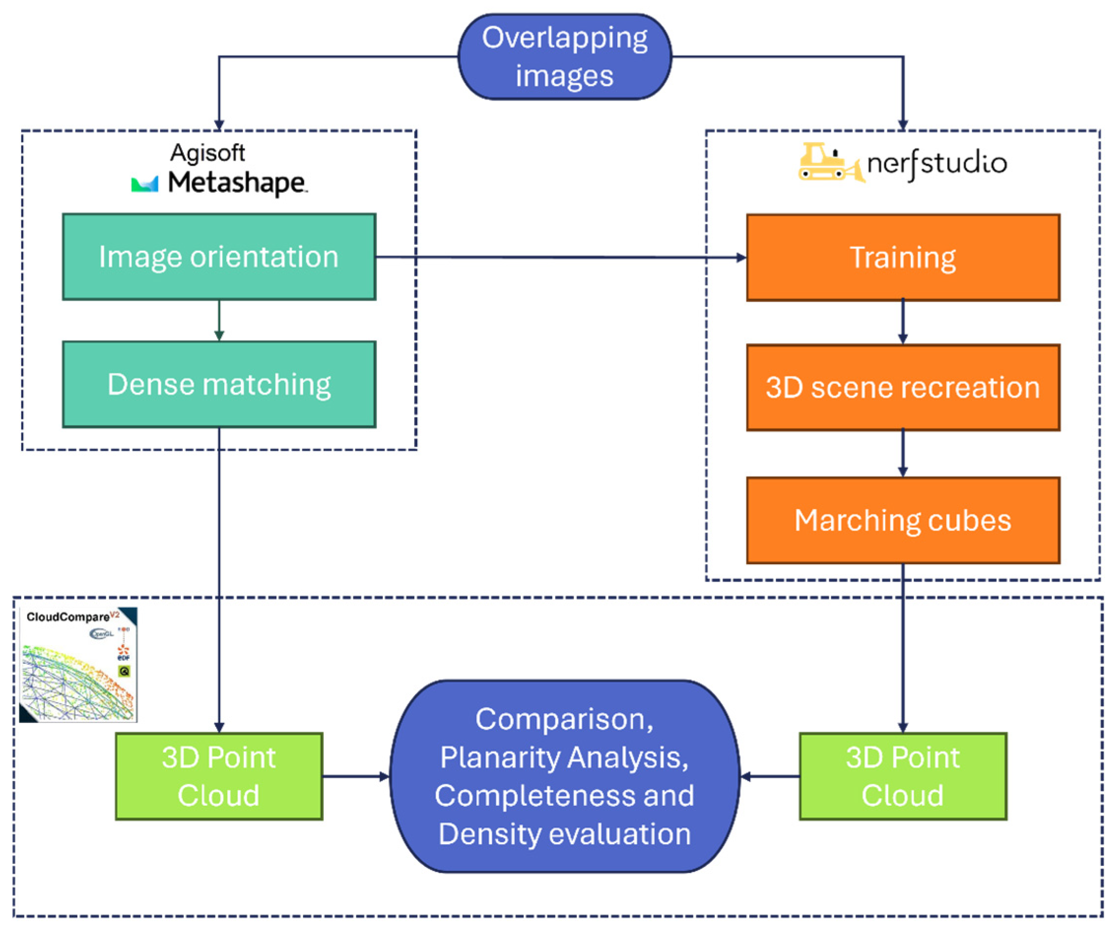
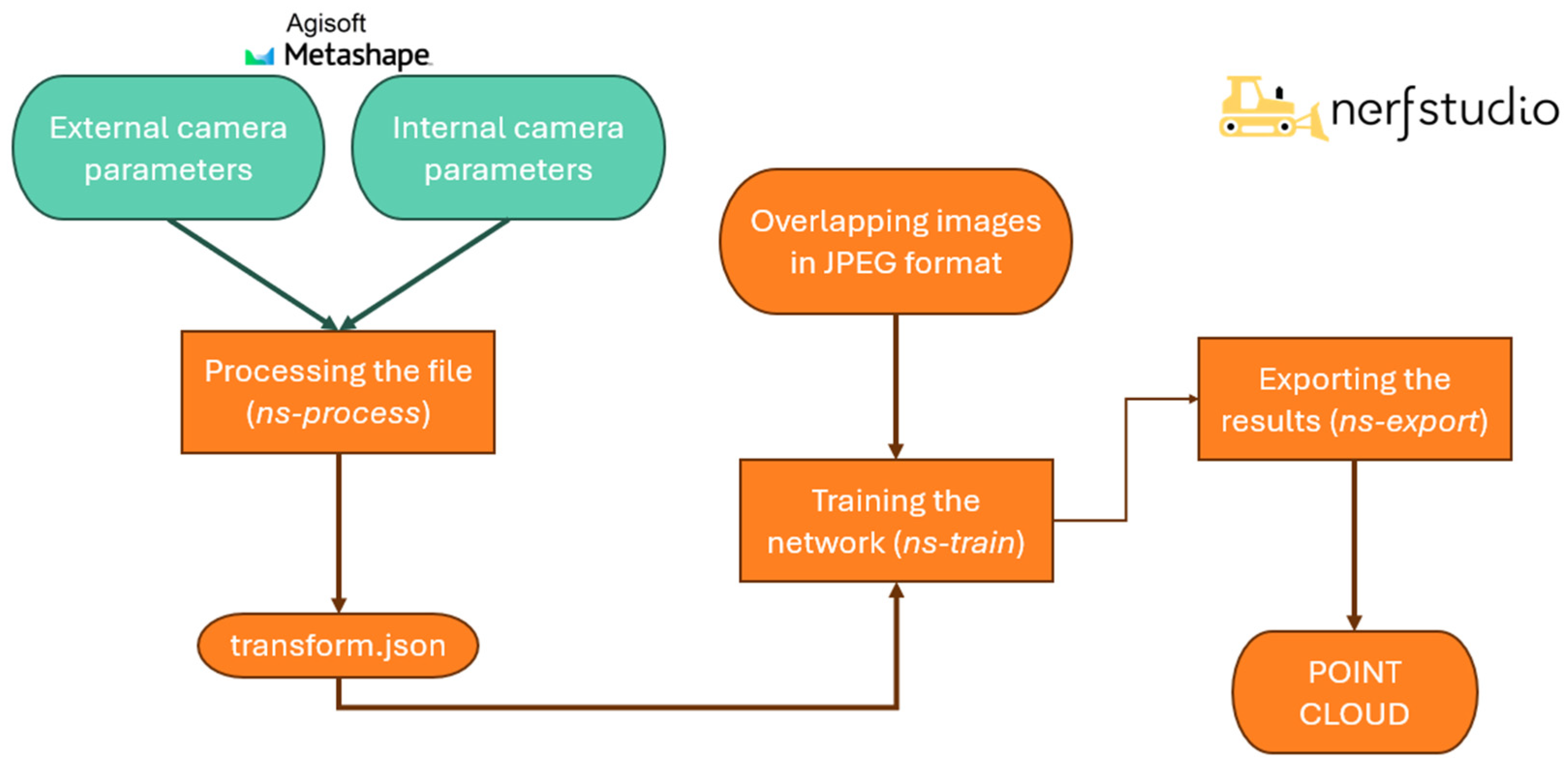
To clarify the experimental approach conducted, the workflow illustrated in Figure 1 is presented. Note that each section of the diagram is explained in greater detail in the respective subsections.
The first step involves acquiring images with a sufficient overlap, as required for photogrammetric surveying, for each dataset chosen for the study. These images are then loaded into Agisoft Metashape to determine the corresponding camera poses and the internal orientation. Additionally, a dense point cloud is generated, serving as a reference for comparison. At this stage, the Agisoft environment is closed, and the processing continues in Nerfstudio. During the training phase, both the acquired images and the corresponding orientations obtained earlier are loaded. This allows for the reconstruction of the 3D scene. Once training is complete, the generated point cloud is extracted. The two point clouds—one obtained from Agisoft Metashape and the other from Nerfstudio—are then compared using CloudCompare software [28]. This comparison is analysed in detail in Section 3, which focuses on the experimental results.
It is important to note that, to correctly compare the Agisoft point cloud (taken as reference cloud) with the point cloud obtained from Nerfstudio (the test cloud), the coordinates of the points within the clouds must be referenced to the same coordinate system. Although both the images and the camera orientations generated in Agisoft are provided as input for processing in Nerfstudio, a different coordinate system is employed during the training phase for 3D scene reconstruction. Once training is completed, this issue is addressed by extracting the point cloud in the same coordinate system as the reference cloud. The only difference between the two systems is a scale factor, which is easily recoverable (see Section 2.2).

2.1. Agisoft Metashape and CloudCompare

To obtain the point cloud that will serve as a reference for subsequent comparisons and to acquire the camera orientations required for processing images in Nerfstudio, the Agisoft Metashape software is selected.
Agisoft Metashape [22] is a standalone software that performs photogrammetric processing of digital images to create 3D spatial data. It can process images from RGB, thermal, or multispectral cameras, including multi-camera systems, to generate spatial data like dense point clouds, textured models, georeferenced orthomosaics, and DSMs/DTMs.
This software is widely recognized within the scientific community for its robustness, flexibility, and reproducibility. It provides advanced control over processing parameters and allows the integration of external orientation files.
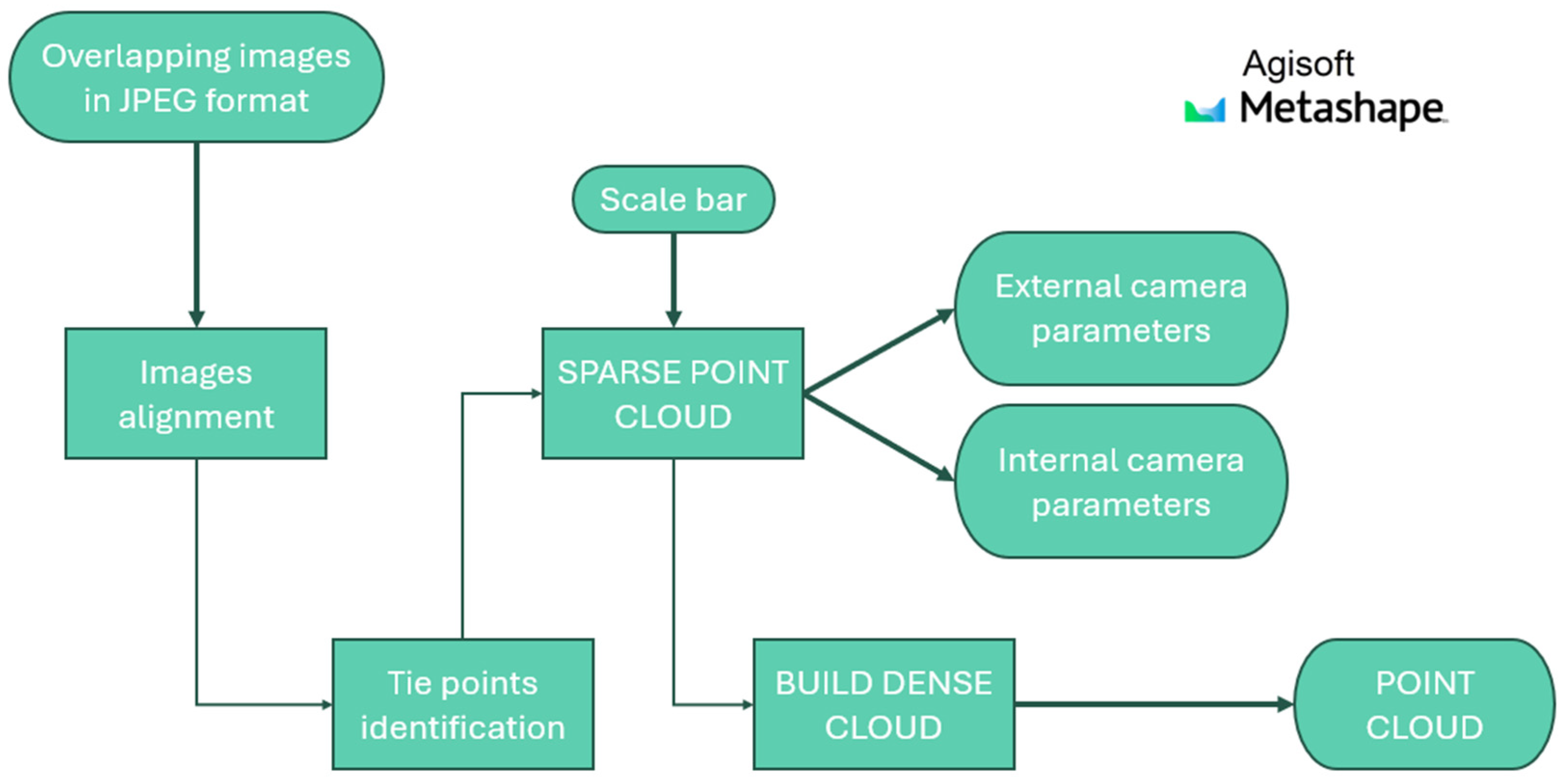
In this environment, images in JPEG format are loaded for each dataset. Blob detectors, such as SIFT and SURF, are employed to identify tie-points and align the images. To be more specific, after loading the acquired images, they are aligned using the High accuracy setting, which processes the photos at their original resolution. This step involves feature points detection and matching procedures, which constitute the basis for the subsequent estimation processes. Then, the software computes the cameras’ positions and orientations (external camera parameters or exterior orientation); additionally, the software estimates the correct camera parameters (internal camera parameters or interior orientation) such as the principal distance, the principal point position, and distortion coefficients. The identified tie points are used to generate an initial sparse point cloud. Including calibrated bars in the images, combined with setting the distance between the coded targets, ensures correct scaling of the object and maintains metric consistency within the 3D model. At this stage, the internal and external camera parameters of the cameras are exported and provided as input to the neural network developed in Nerfstudio. The point cloud is further densified using the High quality setting, where the input images are downscaled by a factor of 4, and subsequently exported to serve as ground truth for the subsequent analysis performed in CloudCompare. This procedure was applied to all datasets (Section 2.3). For dataset D, in addition to the images, an auxiliary file was loaded, containing the external orientation parameters of the cameras.
CloudCompare [28] is an open-source software tool for processing, analysing, and comparing 3D point clouds, and it is used to visualize, measure, and analyse 3D data from laser scanners, photogrammetry, and similar technologies.
Figure 2 schematically illustrates the process described above.

2.2. NeRF and Nerfstudio

The NeRF [7] method has set a new benchmark in synthesizing novel views of complex scenes using only a limited set of input images. The approach models a scene with a fully connected deep network that accepts a continuous 5D coordinate—spatial position (x, y, z) and viewing direction (θ, φ)—and outputs both the volume density and the view-dependent radiance at that point. The network is queried along camera rays, and classical volume rendering techniques are then used to convert these outputs into a final image.
For the purpose of this paper, the Nerfstudio architecture [27] is used. The primary objectives of Nerfstudio are to provide a modular framework, enable real-time visualization to facilitate development, and, crucially, to deliver a highly intuitive and user-friendly interface, allowing seamless integration with real-world data even for users without extensive technical expertise.
The framework focuses on flexibility and usability rather than prioritizing faster rendering or higher-quality results for synthetic scenes. It employs a modular, Python-based approach using PyTorch for CUDA (Torch 2.1.2 with CUDA 11.8), offering greater adaptability compared to the more rigid and faster direct CUDA method. Nerfstudio enables the integration of NeRF into projects with its plug-and-play components.
The modularity of Nerfstudio led to the development of Nerfacto, which combines concepts from various research papers into an optimised approach for NeRF-based 3D reconstruction, strongly inspired by MipNeRF-360 [9]. Nerfacto enhances computational efficiency by using a compact MLP with hash encoding for scene density and a proposal network sampler that iteratively refines samples. To handle unbounded real-world scenes, it uses a “scene contraction” technique, which maps large-scale environments into manageable computational limits. By balancing reconstruction quality and efficiency, Nerfacto proves to be highly effective for large-scale real-world applications.
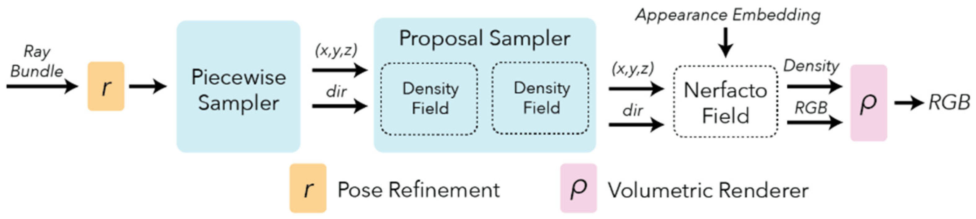
Figure 3 illustrates the method’s pipeline. The process [35] begins with pose refinement to correct camera pose errors and improve sharpness, followed by a piecewise sampler that generates initial samples with higher density near the camera and sparser coverage for distant regions. A proposal sampler then focuses sampling on the most relevant parts of the scene, typically the first surface intersection, which enhances reconstruction quality. Finally, a density field provides a coarse but efficient representation of the scene to guide sampling without requiring high-frequency detail.
To reconstruct the 3D scene, it is essential for the Nerfstudio network to position the images within the spatial domain accurately. To achieve this, the external and internal camera parameters extracted from Agisoft must first undergo an initial processing phase. During this step, the images are also automatically resized so that their maximum dimension does not exceed 1600 px, as required by the Nerfstudio workflow [35]. Only after this step are the processed parameters and images fed into the network to initiate training. In the conducted experiments, the training phase lasted approximately three hours; however, with more powerful hardware, this duration can be significantly reduced. Once training is complete, the point cloud is extracted. To ensure that this point cloud and the one generated by Agisoft share the same coordinate system, when using the ns-export command, it is necessary to change the default setting “save world frame—True”. Figure 4 offers a graphical representation of the key points discussed above.

2.3. Datasets

To ensure a reliable assessment of NeRF’s performance, datasets featuring objects of various shapes and sizes were carefully selected, covering close-range photogrammetry applications (dataset A to C) along with drone-acquired imagery (dataset D):
  • Owl (dataset A);
  • Plush Octopus (dataset B);
  • Sándor Márai Statue (dataset C) [36];
  • UseGeo (dataset D) [40].
A dedicated study was also conducted to assess the actual planarity of the reconstructed surface and its behaviour in regions with strong shadowing. For this purpose, two additional datasets were acquired:
  • Flat Surface (dataset E);
  • Plastic Figure (dataset F).
Table 1 presents the main characteristics of each dataset, while the acquisition method and the configuration used to obtain them are described in the following sub-subsections.

2.3.1. Owl—Dataset A

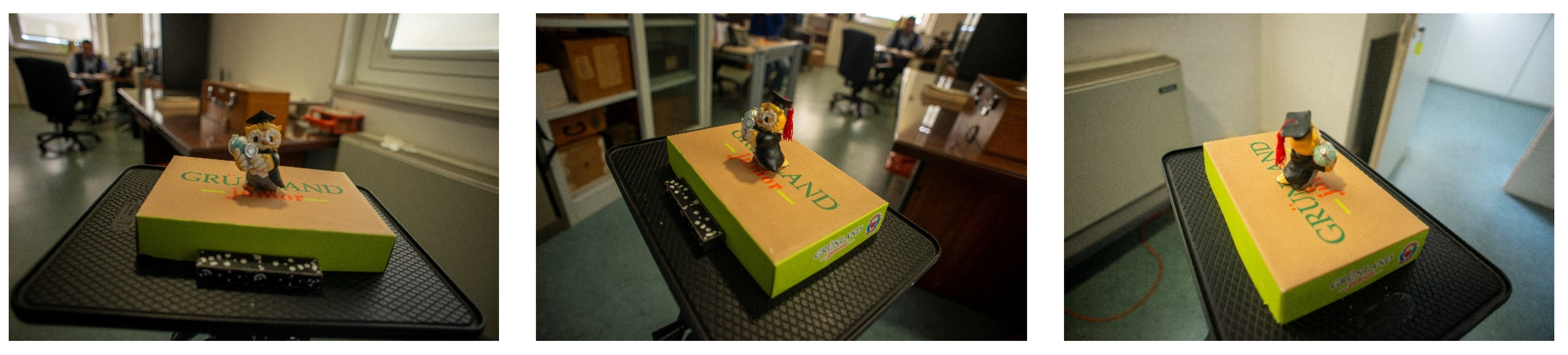
The acquisition of the images forming dataset A (Figure 5) was performed by walking around the object to ensure an overlap of approximately 80% between consecutive images. For operational convenience, the owl was positioned on a tripod at a height of 1.20 m above ground. Furthermore, to provide metric consistency to the model, a calibrated bar made of homogeneous steel was placed (see Table 1, row 1). Due to its small size, this object provides a suitable scenario for assessing NeRF reconstruction performance. The mean standard deviation of the estimated camera positions is 0.09 mm, as computed by the bundle adjustment. These standard deviations quantify the precision of the photogrammetric project and provide an indicator of the reliability of the recovered exterior orientation parameters.

2.3.2. Plush Octopus—Dataset B

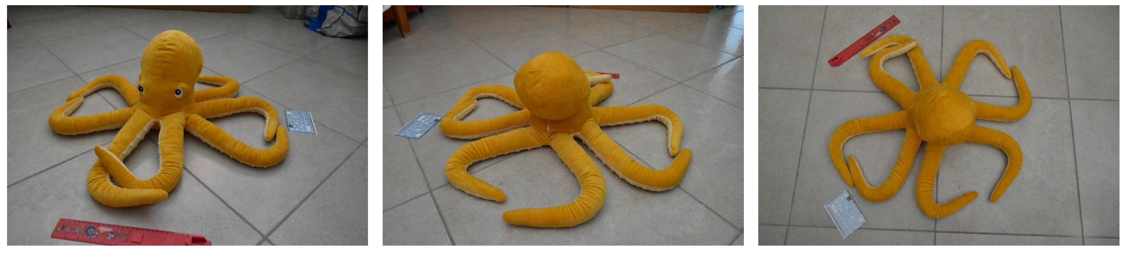
The captured object was placed on the floor to facilitate the acquisition and reconstruction of all eight of its tentacles (Figure 6). The object’s complex geometry makes this dataset suitable for evaluating NeRF reconstruction performance on intricate shapes. To ensure metric consistency in the reconstructed model, two scale bars were positioned. Furthermore, to minimize deformations on the floor plane, the rulers were placed perpendicularly to each other, as shown in Figure 6. The images of dataset B were acquired by rotating around the object, ensuring a certain degree of overlap between consecutive images. For more details, refer to row 2 of Table 1. Following the bundle adjustment, the mean standard deviation of the estimated camera positions is 0.21 mm.

2.3.3. Statue of Sandor Marai—Dataset C

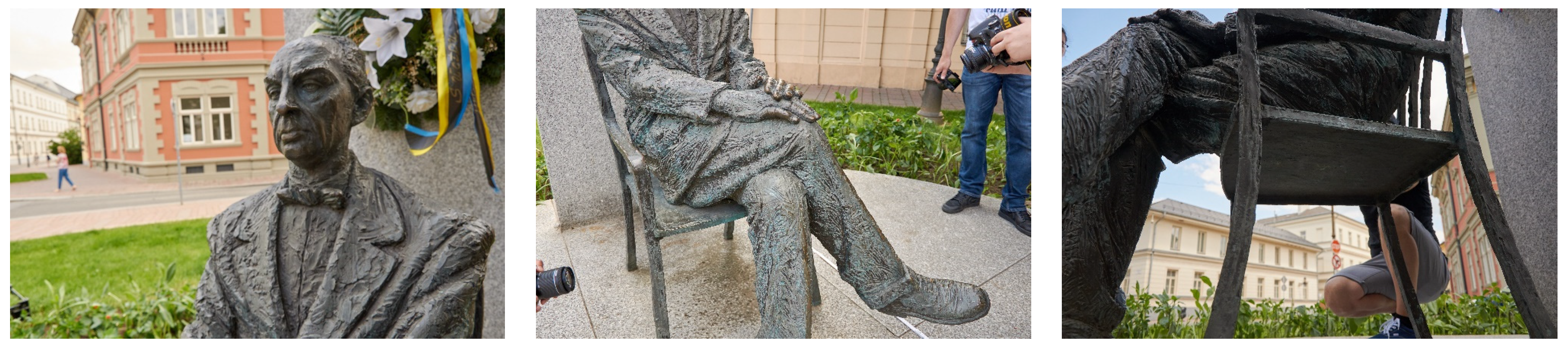
This dataset was downloaded from the OpenHeritage3D [35]. In June 2021, the American non-profit organization CyArk and its Slovakian partner Capturing Reality collaborated in acquiring this dataset and providing a joint training workshop on 3D Documentation for students from the Academy Arts in Banská Bystrica and the Technical University of Košice. This dataset was selected due to the richness of details and complex forms, as well as the atypical capture geometry, allowing assessment of NeRF performance on challenging and non-standard photogrammetric scenarios.
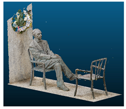
Dataset C, shown in Figure 7, consists of 3 groups of images. For the work described in this paper, the “pex_02” group was selected. To ensure the metric consistency of the model, a measuring tape was placed near the statue and captured in the images (Table 1, row 3). The processing of this dataset yielded a mean standard deviation of 1.05 mm for the estimated camera positions.

2.3.4. UseGeo—Dataset D

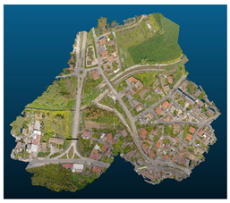
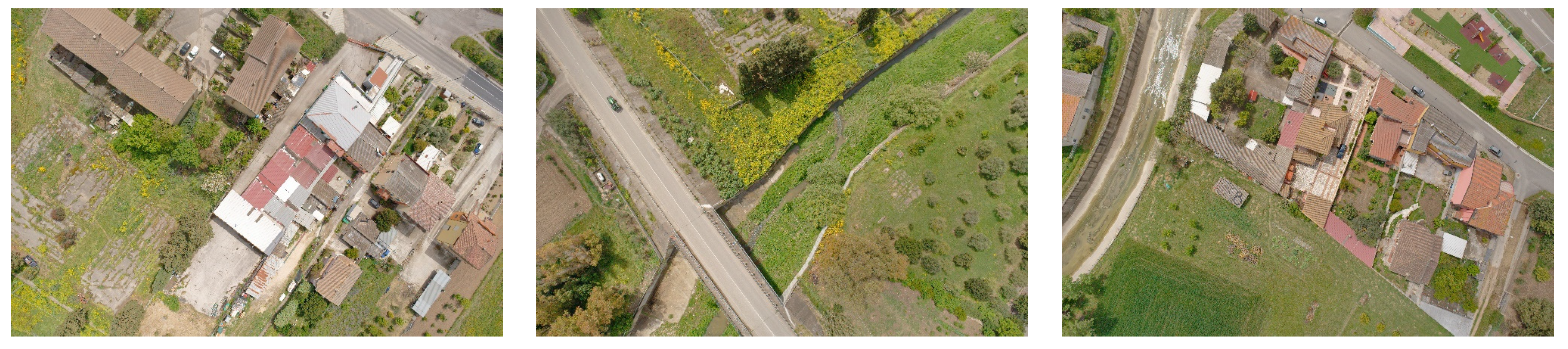
USEGEO [37,38,39,40] is an ISPRS Scientific Initiative aimed at creating and providing a novel, comprehensive dataset for the thorough evaluation of image-based 3D reconstruction algorithms, particularly those applied to datasets collected using UAV platforms. This dataset is characterized by a mean Ground Sampling Distance (GSD) of 2 cm. Along with the imagery, both internal and external camera orientation parameters are provided by the dataset creators. The external parameters, obtained through a hybrid adjustment, were used as initial values and subsequently refined by bundle adjustment. The quality of this refinement can be evaluated by a mean final 3D error on the camera poses of 1.7 cm, with a Root Mean Square Error (RMSE) of 0.9 cm and a 95th percentile error of 3.6 cm. These orientations were adopted as reference input in our processing pipeline to ensure consistent initial conditions for both Agisoft Metashape and NeRF.
Dataset D (Figure 8) offers a large-scale, real-world collection of data that is suitable for various tasks, including monocular depth estimation, multi-view 3D reconstruction (MVS), and more. This large-scale dataset, acquired with a nadir camera configuration, was chosen to evaluate NeRF performance under non-optimal capture geometry conditions. Specifically, the acquired images were divided into three different datasets. The characteristics of the selected dataset are reported in Table 1, row 4.

2.3.5. Flat Surface—Dataset E

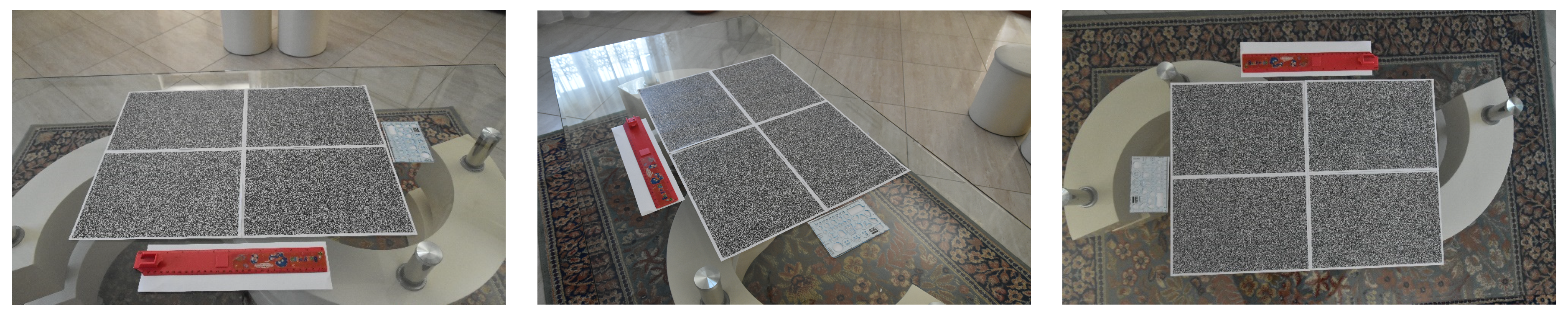
This dataset was specifically designed to evaluate the performance of NeRF in reconstructing planar surfaces. Four A4 sheets with randomly generated patterns were placed on a glass surface (Figure 9). This setup enables Agisoft Metashape to easily identify homologous points, align the images, and ultimately perform the 3D reconstruction of the plane. The images composing dataset E were captured by rotating around the surface to ensure sufficient overlap between consecutive images and create a spherical cap. To maintain metric consistency, the same scale bars used during the acquisition of dataset B were reused and strategically positioned to minimize potential distortion in the reconstructed surface. The processing results yield a mean standard deviation of 0.34 mm for the estimated camera positions. Additional details are provided in Table 1.

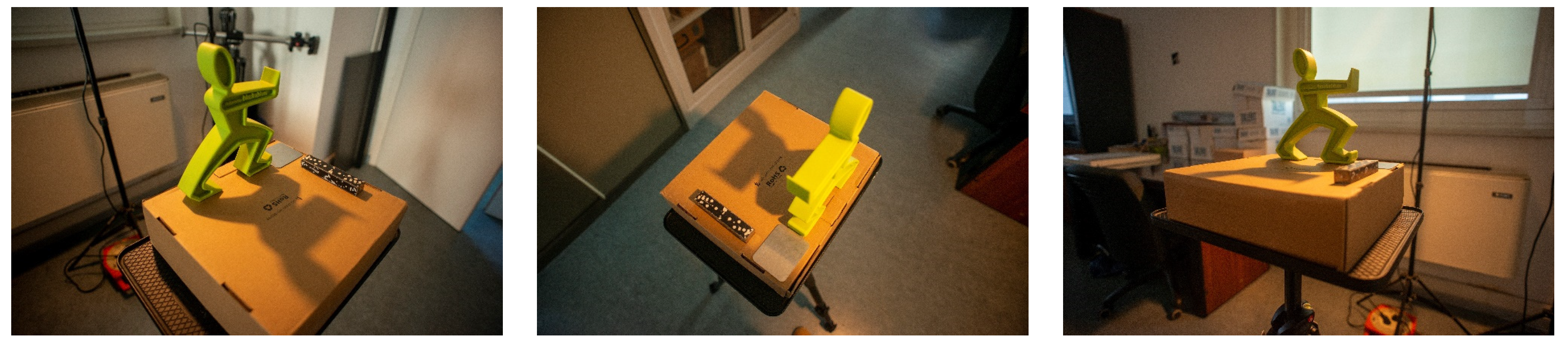
2.3.6. Plastic Figurine—Dataset F

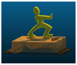
This latter dataset (Figure 10) was collected to assess how shadows affect the reconstruction process. To this end, a human-shaped bookend was placed on a cardboard base at a height of 1.20 m from the ground. A calibrated light lamp (5200 K), with a directed light beam, was used to cast the shadow. The image acquisition technique is consistent with that used to construct datasets A, B, and E. In this case as well, the scale bar used for dataset A was employed to maintain metric consistency in the model. The photogrammetric model was obtained by estimating the camera position with a mean standard deviation of 0.16 mm. Additional information on dataset F is provided in Table 1, row 6.

3. Results

This section describes the comparison performed in CloudCompare [28] to assess the accuracy of NeRF in 3D reconstruction. Prior to analysis, it is essential to remove outliers from both point clouds, particularly the one generated by Nerfstudio. Agisoft Metashape reconstructs the object captured in the images, whereas Nerfstudio reconstructs the entire recorded scene. Table 2 shows the point clouds extracted.
Both point clouds from Nerfstudio and Agisoft Metashape were referred to coordinate systems that share the same origin and spatial orientation but differ in scale. Therefore, a scale factor was applied to the Nerfstudio point cloud to enable proper comparison. This factor was obtained from the orientation file extracted from Agisoft Metashape. Finally, once scaled, a further alignment was performed using the ICP [29] tool to correct a slight vertical shift observed between the two point clouds of all datasets. This ICP was performed leaving rotations and translations unconstrained. These point clouds were then compared using the M3C2 plugin [30] (see Section 3.1).
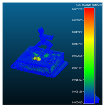
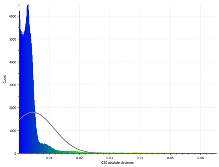
Observing that shadows can alter the morphology of the 3D reconstruction, the C2C distance [31] tool was employed to investigate this effect (Section 3.2). Due to their size, this tool was also used to compare the point clouds representing dataset D.
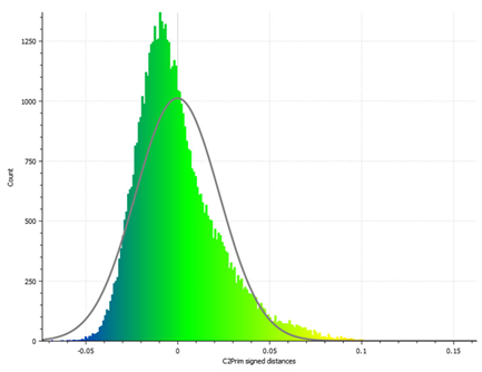
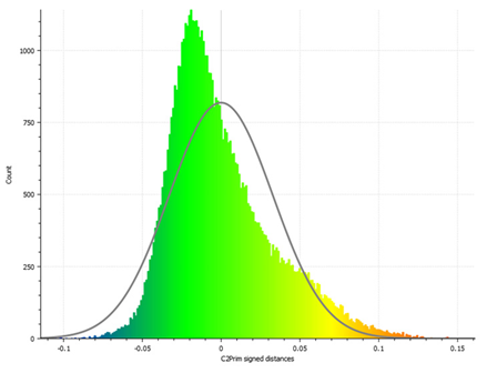
In addition, the C2Prim signed distances [32] tool was adopted to analyse the planarity of the reconstructed surface (Section 3.3).
Moreover, a completeness analysis [33] was conducted to assess the proportion of inlier points in the Nerfstudio point cloud with respect to the reference dataset (see Section 3.4).
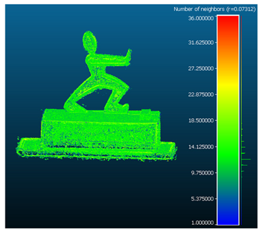
Finally, the point cloud density was evaluated by quantifying the number of neighbouring points using the ‘Compute Geometric Features’ tool [34], applied to both the Agisoft Metashape and Nerfstudio point clouds (Section 3.5).

3.1. Point Cloud Comparison: M3C2

Multiscale Model to Model Cloud Comparison (M3C2) accurately measures orthogonal distances between two point clouds without requiring meshing or gridding, making it robust against missing data and varying point densities [30].
To proceed with the comparison using this plugin, it is necessary to select which point cloud to use as a reference and whether to down sample it or use it in its entirety. Specifically, the entire point cloud extracted from Agisoft Metashape was selected for this purpose.
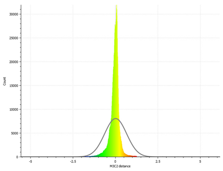
Following the application of M3C2, the comparative evaluation was carried out by analysing the Gaussian distribution and RMSE. These values are illustrated in Table 3 and reported in Table 4.
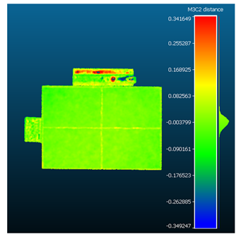
To ensure thorough processing, the plugin was also applied to the final two datasets. The discontinuity observed in the colour map of dataset F, corresponding to the shadowed area, prompted the choice to carry out the comparison using the C2C distances tool (see Section 3.2).
The results of the comparison are presented in the following subsubsections.

3.1.1. Dataset A: Owl

The comparison of the point clouds indicates that Nerfstudio has successfully reconstructed the object, though some limitations are apparent, particularly in the absence of details on vertical surfaces and subtle depressions in shadowed areas. These observations are clearly illustrated in Table 3 and are supported by the RMSE in Table 4, row 1.
The detection of depressed areas both in the point cloud extracted from Nerfstudio and in the results of the comparative analysis has motivated a closer examination of how the presence of shadowed regions affects the reconstruction process (see Section 3.1.6).

3.1.2. Dataset B: Plush Octopus

As with the results of dataset A, the comparison between the point clouds from this dataset further confirms the effectiveness of the reconstruction performed by Nerfstudio, with some noise present in the tentacle area, likely due to the object–camera positioning setup. The results are presented in Table 3 and Table 4.

3.1.3. Dataset C: Statue of Sandor Marai

The images downloaded from the OpenHeritage3D platform [36] and processed by the Nerfstudio network yielded a generally good reconstruction, demonstrating satisfactory reliability. The results are presented in Table 3, row 3 and Table 4, row 3.

3.1.4. Dataset D: UseGeo

As mentioned in the introductory part of this section, the analysis for this dataset was conducted using the C2C distances tool (see Section 3.2.1).

3.1.5. Dataset E: Flat Surface

For this dataset, in addition to evaluating the planarity of the reconstructed surface (see Section 3.3), the overall accuracy of the reconstruction was also analysed. The results presented in Table 3 and Table 4 further validate the consistency of the NeRF-based reconstruction.

3.1.6. Dataset F: Plastic Figurine

The assessment of shadow effects was initially performed using the M3C2 plugin. However, the shadowed region appeared as a void, behaving as a NO DATA area. In contrast, the point cloud generated by Nerfstudio clearly displayed a depression in the region of interest. To ensure a more accurate evaluation of the shadow effect on the reconstruction, the C2C tool was subsequently employed (see Section 3.2.2).

3.2. Point Cloud Comparison Using C2C

To correctly compare datasets D and F, the Cloud to Cloud (C2C) tool [31] was used. This tool enables highly precise point cloud comparison. Specifically, it analyses each point in the reference cloud by identifying the nearest point in the test cloud and calculating the Euclidean distance between them. The results of this comparison are then visualized through a colour map, where variations in hue indicate differences between the two datasets.
Consistently with M3C2, the point cloud extracted from Agisoft Metashape was chosen as the reference.
After applying the tool, the comparative evaluation was conducted by analysing the Gaussian distribution and RMSE. As stated in the previous subsection, since both point clouds are derived from the same set of input images, the mean value is expected to be close to zero. These values are exhibited in Table 5 and reported in Table 6.
The results of the comparison are described in the following subsubsections.

3.2.1. Dataset D: UseGeo

The comparison between the point clouds suggests that Nerfstudio has correctly reconstructed the object, although there is more noticeable noise towards the outer boundary. Nonetheless, the overall reconstruction demonstrates good accuracy and quality, as highlighted by the results shown in Table 5 and Table 6. While it is true that the RMSE and mean values are higher compared to those obtained from dataset F, these values remain more than satisfactory when considering the scale of the scene (approximately half a square kilometre) and the geometry of the camera network (nadiral views). The high RMSE value obtained for this dataset (1.31 m) can be attributed to the specific characteristics of the UseGeo UAV imagery. In particular, the nadir-only acquisition geometry considerably reduces parallax, thereby weakening depth estimation and limiting the geometric constraints required by NeRF to achieve reliable reconstructions. Contrasting typical NeRF applications, which rely on convergent or multi-view camera networks, to the strictly nadiral configuration leads to reduced point density and a noisier cloud, especially at the scene boundaries. Moreover, the large spatial extent of the dataset amplifies these effects, making the reconstruction more prone to local inconsistencies. Despite these limitations, the central portions of the reconstructed area remain visually coherent and geometrically consistent, confirming that the error is not uniformly distributed across the scene.

3.2.2. Dataset F: Plastic Figurine

This comparison clearly highlights the reconstruction error in the shadowed region of the point cloud generated by Nerfstudio, while demonstrating reliable reconstruction in the remaining areas. Table 5 and Table 6 further confirm these results.

3.3. Planarity Analysis: C2Prim Signed Distances

The planarity of the reconstructed surface was evaluated using the C2Prim signed distances tool [32]. This tool is intended to compare a point cloud to a geometric primitive (specifically a plane), quantifying the deviations between the acquired data and the reference primitive, and highlighting areas where the real model diverges from the theoretical design.
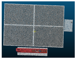
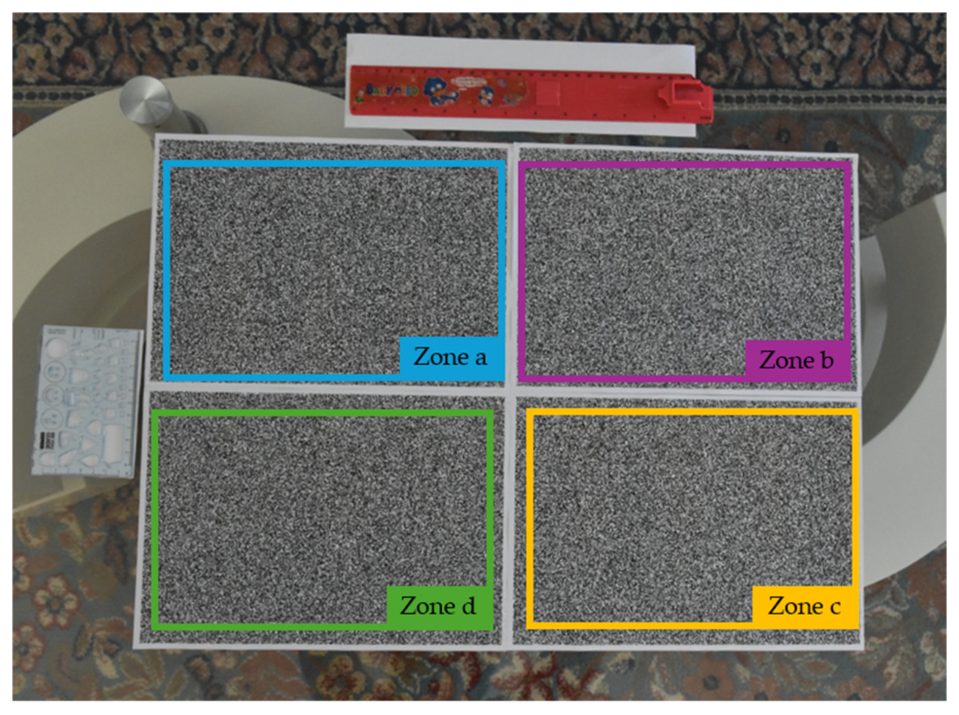
This analysis was conducted for both the reconstructions performed by Nerfstudio and Agisoft Metashape. Specifically, four representative portions were extracted from each point cloud, corresponding to the four quadrants of the plane. Figure 11 depicts these portions.
Starting with the point cloud generated by Agisoft Metashape, portion A was extracted (Figure 11), and an ideal plane was created using the least-squares technique. After selecting this latter entity and its corresponding portion of the point cloud, the C2Prim signed distances tool was applied. The evaluation results were obtained by analysing the Gaussian distribution and RMSE. The deviation between the ideal plane and the reconstruction was expected to be close to zero. This procedure was similarly applied to the other portions of the point cloud, as well as to those reconstructed by NeRF. The colour maps are presented in Table 7, and the mean and RMSE values obtained are reported in Table 8.
The findings indicate that both Agisoft Metashape and Nerfstudio perform effectively in reconstructing planar surfaces. In addition to the statistical indicators reported (Mean error, RMSE), the planarity analysis provides a direct measure of the geometric fidelity of the reconstructed surfaces. Small deviations from the ideal plane (on the order of sub-millimetres) demonstrate that both methods can preserve planar geometries with high accuracy. Furthermore, as indicated by the RMSE values across the four quadrants, it is confirmed that the errors are of the same order of magnitude, suggesting that both methods achieve stable and repeatable performance in reconstructing planar geometries. By analyzing four representative quadrants of the reconstructed plane, we ensured that errors were well-distributed and not confined to a specific region. This provides more substantial confidence that NeRF is able to maintain metric coherence at the global model level, even though its point cloud density is lower than that of Metashape. Thus, the planarity analysis not only validates local accuracy but also serves as an indirect metric for assessing the suitability of NeRF reconstructions in applications requiring geometric reliability.

3.4. Completeness

The completeness analysis was conducted by considering the Metashape point cloud as the most complete, and therefore, it was used as the reference. Within the tools provided by CloudCompare, the “Compute 2.5D Volume” function [33] was selected for this purpose. Specifically, the Metashape cloud was set as the ground truth and the Nerfstudio cloud as the ceil, establishing the respective roles in the analysis.
Subsequently, a 2.5D grid was defined by setting the step size to 16 times the Ground Sampling Distance (GSD) to ensure an accurate and consistent evaluation across all datasets, which differ in scale and resolution. At this stage, the points from the Nerfstudio cloud were projected onto the reference Metashape cloud. It is worth noting that both point clouds are defined in the same coordinate system, allowing a direct and meaningful comparison of their spatial characteristics. Points that did not find a corresponding match within the reference were classified as missing. The completeness rate was then computed as a percentage based on the ratio of matched points to the total number of expected points. The results obtained through this procedure are summarized in Table 9 and offer insight into the performance differences across datasets.
The higher completeness values further confirm the strong reconstruction capabilities of Nerfstudio. However, the values for datasets C and D are notably lower (<85%) compared to the others.

3.5. Point Clouds Density

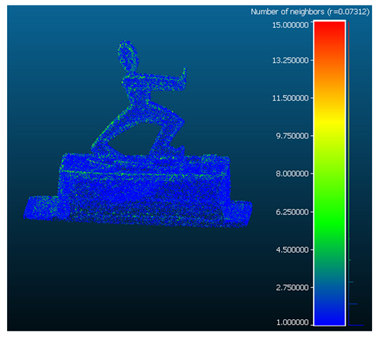
Point cloud density was computed by quantifying the mean number of neighbouring points within a sphere with a set radius of 8 GSD [34]. This analysis was performed for each point in every pair of point clouds derived from the datasets. The results are presented in Table 10.
The analysis of the point cloud density clearly shows that the cloud generated by Agisoft is significantly denser than the one produced by Nerfstudio. This difference had already emerged from a visual inspection, but the experimental analysis has confirmed it with clear quantitative evidence.

4. Discussion

This study aimed to evaluate the accuracy of Neural Radiance Fields (NeRFs) in reconstructing 3D models, deliberately extending its original application beyond novel view synthesis. By comparing results obtained using the Nerfstudio framework with those produced by the photogrammetric software Agisoft Metashape, the goal was to assess NeRF’s potential as a reliable alternative in geometric reconstruction tasks. A variety of objects were considered, differing in scale and camera network, including small items with well-controlled lighting conditions and pronounced shadow areas, flat-surfaced objects, scenes captured via drone covering large areas, and highly three-dimensional subjects. The results presented in Section 3 highlight that, in general, the error (RMSE) increases as the object’s size increases. Issues were encountered in reconstructing areas with strong shadowing (dataset E), resulting in depressed regions where no such characteristic is present. In the case of flat surfaces with very simple geometries, the reconstruction reached very high accuracy levels, demonstrating the method’s strength in handling such objects. A low completeness value was observed for datasets C [36] and D [40]: in the case of dataset C, this is due to the highly three-dimensional nature of the object, which presents challenges for the 2.5D model employed; for dataset D, the low completeness is likely due to the pose geometry, which relies on nadiral views. The high RMSE value reported for dataset D can also be explained by the acquisition geometry. NeRF was originally designed to operate with convergent or multi-view image networks, which provide sufficient angular diversity for stable depth estimation. In contrast, the nadiral camera poses of the UAV dataset are poorly suited to this framework, resulting in reduced point density, noisier reconstructions. In dataset C, noticeable gaps were visible on the point cloud, probably stemming from insufficient data due to an inadequate number of images covering those specific areas. Nevertheless, the overall outcome was still promising, suggesting that the method retains potential even under suboptimal data conditions. Dataset E, which represents a flat surface, shows very high completeness values, emphasizing the method’s effectiveness in reconstructing planar geometries. Conversely, despite dataset F having a similar scale and acquisition geometry to dataset A, the presence of a highly pronounced shadowed area and the resulting depression in the point cloud led to a noticeable reduction in completeness. This is likely since NeRF models the radiance field at each point in the scene to generate photo-realistic views by leveraging volume rendering techniques [7]. In areas affected by strong shadows, insufficient or inconsistent radiance information can lead to poor density estimation and incorrect reconstruction artifacts.
Additionally for all datasets, the point cloud density generated by NeRF was found to be lower than that of Agisoft Metashape. This lower density is partly due to the intrinsic differences between the two reconstruction technologies: Metashape relies on explicit dense pixel correspondences, whereas NeRF generates points via volumetric sampling. Moreover, in the Nerfstudio workflow, all input images are automatically resized so that their maximum dimension does not exceed 1600 px, which can further influence the sampling density. This lower density could impact the overall level of detail in the reconstructed models, particularly in areas with fine geometric features.
The findings reveal that, while NeRF was not designed for metric accuracy, its reconstructed point clouds exhibit a degree of spatial consistency that is, in some cases, comparable to that of traditional photogrammetric methods. These results highlight NeRF’s capability to generate geometrically coherent 3D reconstructions with accurate camera poses, even if the underlying principles differ significantly from those of conventional approaches.
While this spatial consistency is encouraging, the reduced density of NeRF-derived point clouds may still introduce local gaps or incomplete areas in the reconstructions. Such limitations can affect downstream applications that rely on high completeness, particularly surface modeling and volume estimation. Therefore, although NeRF demonstrates strong potential for generating geometrically coherent 3D reconstructions, its applicability to tasks requiring precise surface or volumetric measurements should be carefully assessed.
Given the diversity of the test cases adopted in this study, it would be worthwhile to further investigate NeRF’s performance, specifically within the Nerfstudio environment, across an even broader range of contexts. Challenging scenarios involving poor lighting, dynamic elements, or low-texture surfaces could provide deeper insights into the method’s limitations and help define the boundaries of its applicability.
Another promising research direction concerns the automation and optimization of camera pose estimation. While the use of Agisoft-derived poses contributed to the stability and accuracy of the training pipeline in this work, future studies could focus on developing integrated solutions within Nerfstudio that combine classical structure-from-motion techniques with learning-based approaches, enhancing both precision and scalability.
Lastly, expanding the evaluation to include temporal or dynamic datasets could open new avenues for applying NeRF to tasks such as structural monitoring, cultural heritage preservation, and real-time reconstruction for robotics and inspection applications.

5. Conclusions

This work has evaluated the effectiveness of Neural Radiance Fields (NeRFs), using the Nerfacto method within the Nerfstudio framework, in generating accurate 3D reconstructions for metric purposes. By comparing the results with those obtained through Agisoft Metashape, a well-established photogrammetric software, the study has highlighted both the strengths and limitations of NeRF in this context.
The analysis showed that NeRF can achieve high accuracy when reconstructing planar and well-lit surfaces, while its performance decreases in the presence of shadows, complex geometries, or large-scale scenes. Completeness and point cloud density were generally lower than those of the photogrammetric reference, particularly under challenging conditions. Nevertheless, the spatial coherence of the NeRF-derived models, supported by accurate camera pose estimation, demonstrates their potential for certain geometric reconstruction tasks.
Although NeRF is not yet suitable for rigorous photogrammetric applications, it shows significant promise and is clearly evolving in that direction. Future research should further explore its applicability to more diverse and demanding scenarios, focusing on optimizing the reconstruction pipeline, particularly in terms of pose estimation, point cloud density, and robustness to varying lighting conditions, as pronounced shadows may affect the morphology of the 3D reconstruction. These developments could enable NeRF to become a reliable alternative for accurate 3D reconstruction tasks in the near future.

Author Contributions

Conceptualization, S.D.P., A.G. and G.F.; methodology, S.D.P. and A.G.; software, A.G.; validation, A.G., S.D.P. and G.F.; formal analysis, A.G. and S.D.P.; investigation, A.G.; resources, S.D.P. and G.F.; data curation, A.G. and S.D.P.; writing—original draft preparation, A.G.; writing—review and editing, A.G., S.D.P. and G.F.; visualization, A.G.; supervision, S.D.P.; project administration, S.D.P. and G.F.; funding acquisition, S.D.P. All authors have read and agreed to the published version of the manuscript.

Funding

This research received no external funding.

Institutional Review Board Statement

Not applicable.

Informed Consent Statement

Not applicable.

Data Availability Statement

The data presented in this study is available on request from the corresponding author.

Acknowledgments

The authors would like to sincerely acknowledge the Laboratory of Photogrammetry of the Department of Applied Science, University of Naples “Parthenope”, for their invaluable contribution to this research. In particular, the authors are grateful to the laboratory team for their expertise and dedication in preparing the original dataset used, which was essential for the analyses presented in this study. Their technical support, meticulous work, and constructive input have greatly enhanced the quality and reliability of the results. During the preparation of this manuscript, the authors used ChatGPT (OpenAI, GPT-4o, August 2025 release) for the purposes of language editing and improving clarity. The authors have reviewed and edited the output and take full responsibility for the content of this publication.

Conflicts of Interest

The authors declare no conflicts of interest.

Abbreviations

The following abbreviations are used in this manuscript:
C2CCloud to Cloud
C2PrimCloud to Primitive
DSMDigital Surface Model
DTMDigital Terrain Model
GSDGround Sampling Distances
M3C2Multiscale Model to Model Cloud Comparison
MLPMulti Layer Perceptron
MVSMulti-View Stereo
NeRFNeural Radiance Field
NRNot Reported
RMSERoot Mean Square Error
SIFTScale-Invariant Feature Transform
SfMStructure for Motion
SURFSpeeded Up Robust Features

References

  1. Zhou, L.; Wu, G.; Zuo, Y.; Chen, X.; Hu, H. A comprehensive review of vision-based 3d reconstruction methods. Sensors 2024, 24, 2314. [Google Scholar] [CrossRef] [Scilit] [PubMed]
  2. Bevilacqua, M.G.; Russo, M.; Giordano, A.; Spallone, R. 3D reconstruction, digital twinning, and virtual reality: Architectural heritage applications. In Proceedings of the 2022 IEEE Conference on Virtual Reality and 3D User Interfaces Abstracts and Workshops (VRW), Christchurch, New Zealand, 12–16 March 2022. [Google Scholar]
  3. Pepe, M.; Alfio, V.S.; Costantino, D. UAV platforms and the SfM-MVS approach in the 3D surveys and modelling: A review in the cultural heritage field. Appl. Sci. 2022, 12, 12886. [Google Scholar] [CrossRef] [Scilit]
  4. Maken, P.; Gupta, A. 2D-to-3D: A review for computational 3D image reconstruction from X-ray images. Arch. Comput. Methods Eng. 2023, 30, 85–114. [Google Scholar] [CrossRef] [Scilit]
  5. de Oliveira Manduca Palmiero, H.; Ribas, E.C.; Carlotti, C.G., Jr.; Figueiredo, E.G. Anatomical assessment of cerebral sulci and gyri for neuroanatomy education using photogrammetry technique to generate 3D-tridimensional models. Neurosurg. Rev. 2025, 48, 172. [Google Scholar] [CrossRef] [Scilit] [PubMed]
  6. Mildenhall, B.; Srinivasan, P.P.; Ortiz-Cayon, R.; Kalantari, N.K.; Ramamoorthi, R.; Ng, R.; Kar, A. Local light field fusion: Practical view synthesis with prescriptive sampling guidelines. ACM Trans. Graph. (ToG) 2019, 38, 29. [Google Scholar] [CrossRef] [Scilit]
  7. Mildenhall, B.; Srinivasan, P.P.; Tancik, M.; Barron, J.T.; Ramamoorthi, R.; Ng, R. Nerf: Representing scenes as neural radiance fields for view synthesis. Commun. ACM 2021, 65, 99–106. [Google Scholar] [CrossRef] [Scilit]
  8. Barron, J.T.; Mildenhall, B.; Tancik, M.; Hedman, P.; Martin-Brualla, R.; Srinivasan, P.P. Mip-nerf: A multiscale representation for anti-aliasing neural radiance fields. In Proceedings of the IEEE/CVF International Conference on Computer Vision, Montreal, QC, Canada, 10–17 October 2021. [Google Scholar]
  9. Barron, J.T.; Mildenhall, B.; Verbin, D.; Srinivasan, P.P.; Hedman, P. Mip-nerf 360: Unbounded anti-aliased neural radiance fields. In Proceedings of the IEEE/CVF Conference on Computer Vision and Pattern Recognition, New Orleans, LA, USA, 18–24 June 2022. [Google Scholar]
  10. Jiang, Y.; Hedman, P.; Mildenhall, B.; Xu, D.; Barron, J.T.; Wang, Z.; Xue, T. Alignerf: High-fidelity neural radiance fields via alignment-aware training. In Proceedings of the IEEE/CVF Conference on Computer Vision and Pattern Recognition, Vancouver, BC, Canada, 17–24 June 2023. [Google Scholar]
  11. Verbin, D.; Srinivasan, P.P.; Hedman, P.; Mildenhall, B.; Attal, B.; Szeliski, R.; Barron, J.T. Nerf-casting: Improved view-dependent appearance with consistent reflections. In Proceedings of the SIGGRAPH Asia 2024, Tokyo, Japan, 3–6 December 2024; pp. 1–10. [Google Scholar]
  12. Li, R.; Fidler, S.; Kanazawa, A.; Williams, F. Nerf-xl: Scaling nerfs with multiple gpus. In Proceedings of the European Conference on Computer Vision, Milan, Italy, 29 September–4 October 2024. [Google Scholar]
  13. Kotcov, A.; Dronova, M.; Cheremnykh, V.; Karaf, S.; Tsetserukou, D. AirNeRF: 3D reconstruction of human with drone and NeRF for future communication systems. In Proceedings of the 2024 IEEE 20th International Conference on Automation Science and Engineering (CASE), Bari, Italy, 28 August–1 September 2024. [Google Scholar]
  14. Fabra, L.; Solanes, J.E.; Muñoz, A.; Martı, A.; Alabau, A.; Gracia, L. Application of Neural Radiance Fields (NeRFs) for 3D model representation in the industrial metaverse. Appl. Sci. 2024, 14, 1825. [Google Scholar] [CrossRef] [Scilit]
  15. Li, K.; Schmidt, S.; Rolff, T.; Bacher, R.; Leemans, W.; Steinicke, F. Magic nerf lens: Interactive fusion of neural radiance fields for virtual facility inspection. Front. Virtual Real. 2024, 5, 1377245. [Google Scholar] [CrossRef] [Scilit]
  16. Azzarelli, A.; Anantrasirichai, N.; Bull, D.R. Reviewing Intelligent Cinematography: AI research for camera-based video production. arXiv 2024, arXiv:2405.05039. [Google Scholar] [CrossRef] [Scilit]
  17. Wu, X.; Wang, H.; Katsaggelos, A.K. Automatic Camera Movement Generation with Enhanced Immersion for Virtual Cinematography. IEEE Trans. Multimed. 2025, 27, 5241–5254. [Google Scholar] [CrossRef] [Scilit]
  18. Zhou, A.; Kim, M.J.; Wang, L.; Florence, P.; Finn, C. NeRF in the Palm of Your Hand: Corrective Augmentation for Robotics via Novel-View Synthesis. In Proceedings of the IEEE/CVF Conference on Computer Vision and Pattern Recognition (CVPR), Vancouver, BC, Canada, 17–24 June 2023. [Google Scholar]
  19. Zou, X.; Zhang, Z.; Schwarz, A.; Armand, M.; Martin-Gomez, A. ARthroNeRF: Field of View Enhancement of Arthroscopic Surgeries using Augmented Reality and Neural Radiance Fields. In Proceedings of the 2024 IEEE International Symposium on Mixed and Augmented Reality (ISMAR), Bellevue, WA, USA, 21–25 October 2024. [Google Scholar]
  20. Pepe, M.; Alfio, V.S.; Costantino, D. Assessment of 3d model for photogrammetric purposes using ai tools based on nerf algorithm. Heritage 2023, 6, 5719–5731. [Google Scholar] [CrossRef] [Scilit]
  21. Müller, T.; Evans, A.; Schied, C.; Keller, A. Instant neural graphics primitives with a multiresolution hash encoding. ACM Trans. Graph. (TOG) 2022, 41, 102. [Google Scholar] [CrossRef] [Scilit]
  22. Agisoft Metashape. Available online: https://www.agisoft.com/ (accessed on 17 May 2024).
  23. Colmap. Available online: https://colmap.github.io/ (accessed on 5 September 2024).
  24. Remondino, F.; Karami, A.; Yan, Z.; Mazzacca, G.; Rigon, S.; Qin, R. A critical analysis of NeRF-based 3D reconstruction. Remote Sens. 2023, 15, 3585. [Google Scholar] [CrossRef] [Scilit]
  25. Condorelli, F.; Rinaudo, F.; Salvadore, F.; Tagliaventi, S. A comparison between 3D reconstruction using nerf neural networks and mvs algorithms on cultural heritage images. Int. Arch. Photogramm. Remote Sens. Spat. Inf. Sci. 2021, 43, 565–570. [Google Scholar] [CrossRef] [Scilit]
  26. Murtiyoso, A.; Grussenmeyer, P. Initial assessment on the use of state-of-the-art NeRF neural network 3d reconstruction for heritage documentation. Int. Arch. Photogramm. Remote Sens. Spat. Inf. Sci. 2023, 48, 1113–1118. [Google Scholar] [CrossRef] [Scilit]
  27. Tancik, M.; Weber, E.; Ng, E.; Li, R.; Yi, B.; Wang, T.; Kristoffersen, A.; Austin, J.; Salahi, K.; Ahuja, A.; et al. Nerfstudio: A modular framework for neural radiance field development. In Proceedings of the ACM SIGGRAPH 2023 Conference, Los Angeles, CA, USA, 6–10 August 2023. [Google Scholar]
  28. CloudCompare. Available online: https://www.danielgm.net/cc/ (accessed on 10 June 2024).
  29. ICP. Available online: https://www.cloudcompare.org/doc/wiki/index.php/ICP (accessed on 17 May 2024).
  30. Lague, D.; Brodu, N.; Leroux, J. Accurate 3D comparison of complex topography with terrestrial laser scanner: Application to the Rangitikei canyon (NZ). ISPRS J. Photogramm. Remote Sens. 2013, 82, 10–26. [Google Scholar] [CrossRef] [Scilit]
  31. CloudCompare/C2C Distance. Available online: https://www.cloudcompare.org/doc/wiki/index.php/Distances_Computation (accessed on 10 June 2024).
  32. CloudCompare/C2Prim Signed Distances. Available online: https://cloudcompare.org/doc/wiki/index.php/Cloud-to-Primitive_Distance (accessed on 10 June 2024).
  33. Cloudcompare/Compute 2.5D Volume. Available online: https://www.cloudcompare.org/doc/wiki/index.php/2.5D_Volume (accessed on 15 June 2024).
  34. CloudCompare/Compute Geometric Features. Available online: https://www.cloudcompare.org/doc/wiki/index.php/Compute_geometric_features (accessed on 9 June 2024).
  35. Nerfstudio. Available online: https://docs.nerf.studio/ (accessed on 5 May 2024).
  36. OpenHeritage3D. Available online: https://openheritage3d.org/project.php?id=75ra-jg84 (accessed on 20 June 2024).
  37. Nex, F.; Zhang, N.; Remondino, F.; Farella, E.M.; Qin, R.; Zhang, C. Benchmarking the extraction of 3D geometry from UAV images with deep learning methods. Int. Arch. Photogramm. Remote Sens. Spat. Inf. Sci.-ISPRS Arch. 2023, 48, 123–130. [Google Scholar] [CrossRef] [Scilit]
  38. Nex, F.; Stathopoulou, E.K.; Remondino, F.; Yang, M.Y.; Madhuanand, L.; Yogender, Y.; Alsadik, B.; Weinmann, M.; Jutzi, B.; Qin, R. UseGeo-A UAV-based multi-sensor dataset for geospatial research. ISPRS Open J. Photogramm. Remote Sens. 2024, 13, 100070. [Google Scholar] [CrossRef] [Scilit]
  39. Hermann, M.; Weinmann, M.; Nex, F.; Stathopoulou, E.K.; Remondino, F.; Jutzi, B.; Ruf, B. Depth estimation and 3D reconstruction from UAV-borne imagery: Evaluation on the UseGeo dataset. ISPRS Open J. Photogramm. Remote Sens. 2024, 13, 100065. [Google Scholar] [CrossRef] [Scilit]
  40. UseGeo Dataset. Available online: https://github.com/3DOM-FBK/usegeo (accessed on 16 November 2024).
Figure 1. Graphical representation of the work settings adopted, and the core elaborations conducted.
Geomatics 06 00004 g001
Figure 2. Workflow of the steps performed in Agisoft Metashape.
Geomatics 06 00004 g002
Figure 3. Overview pipeline for Nerfacto. The method refines camera poses to reduce alignment errors, uses a piecewise sampler to balance near and far sampling, applies a proposal sampler to concentrate on the most relevant regions of the scene, and relies on a coarse density field to efficiently guide reconstruction.
Geomatics 06 00004 g003
Figure 4. Workflow of the steps performed in Nerfstudio.
Geomatics 06 00004 g004
Figure 5. Some images from dataset A, capturing different angles of the same object.
Geomatics 06 00004 g005
Figure 6. Some images from dataset B, showing different perspectives of the same object.
Geomatics 06 00004 g006
Figure 7. Some images from dataset C, captured from varying viewpoints of the same object.
Geomatics 06 00004 g007
Figure 8. Some images from dataset D, showing different angles of the same object—a town in the western part of Sardinia, Italy.
Geomatics 06 00004 g008
Figure 9. Some images from dataset E, capturing different perspectives of the same object.
Geomatics 06 00004 g009
Figure 10. Some images from dataset F, captured from varying viewpoints of the same object.
Geomatics 06 00004 g010
Figure 11. The four “zones” extracted from the point clouds.
Geomatics 06 00004 g011
Table 1. Summary of the main characteristics of the acquired datasets.
DatasetNumber of ImagesCamera
Model
Equivalent Focal Length [mm]Scale BarMean GSD
[mm/pix]
Lighting
Conditions
Acquisition Time
A48Nikon D800E, Nikon Corporation, Tokyo, Japan2078.22 mm0.07Artificial light (indoor)10:00
B77Nikon D5600, Nikon Corporation, Tokyo, Japan2726.0 cm &
10.0 cm
0.16Natural light (indoor)14:00
C168Nikon D5600, Nikon Corporation, Tokyo, Japan272.000 m0.2Natural light (outdoor)NR
D224SONY ILCE-7RM3, Sony Corporation, Tokyo, Japan21External camera orientation17Natural light (outdoor)13:00
E100Nikon D5600, Nikon Corporation, Tokyo, Japan2726.0 cm &
10.0 cm
0.17Natural light (indoor)15:30
F95Nikon D800E, Nikon Corporation, Tokyo, Japan2078.22 mm0.09Artificial light (indoor)10:30
Table 2. Point clouds extracted from Agisoft Metashape and Nerfstudio, visualized in CloudCompare.
DatasetAgisoft MetashapeNerfstudio
AGeomatics 06 00004 i001Geomatics 06 00004 i002
BGeomatics 06 00004 i003Geomatics 06 00004 i004
CGeomatics 06 00004 i005Geomatics 06 00004 i006
DGeomatics 06 00004 i007Geomatics 06 00004 i008
EGeomatics 06 00004 i009Geomatics 06 00004 i010
FGeomatics 06 00004 i011Geomatics 06 00004 i012
Table 3. Colour map showing the result of the M3C2 distances plugin. Due to the large size of dataset D and to reduce processing time, the C2C distance tool was used instead.
DatasetM3C2Gaussian Distribution
AGeomatics 06 00004 i013Geomatics 06 00004 i014
BGeomatics 06 00004 i015Geomatics 06 00004 i016
CGeomatics 06 00004 i017Geomatics 06 00004 i018
EGeomatics 06 00004 i019Geomatics 06 00004 i020
FGeomatics 06 00004 i021Geomatics 06 00004 i022
Table 4. RMSE obtained from the comparison between the point cloud extracted from Agisoft Metashape (reference cloud) and the one extracted from Nerfstudio (test cloud), performed using the M3C2 plugin.
DatasetRMSE [mm]
A2.52
B6.45
C16.42
E0.72
F5.77
Table 5. Colour map showing the result of the C2C tool.
DatasetC2CGaussian Distribution
DGeomatics 06 00004 i023Geomatics 06 00004 i024
FGeomatics 06 00004 i025Geomatics 06 00004 i026
Table 6. Mean value and RMSE obtained from the comparison between the point cloud extracted from Agisoft Metashape (reference cloud) and the one extracted from Nerfstudio (test cloud), performed using the C2C tool.
DatasetMean ValueRMSE
D0.56 m1.31 m
F4.58 mm8.38 mm
Table 7. Colour map showing the result of the C2Prim signed distances tool.
ZoneAgisoft MetashapeGaussian Distribution
aGeomatics 06 00004 i027Geomatics 06 00004 i028
bGeomatics 06 00004 i029Geomatics 06 00004 i030
cGeomatics 06 00004 i031Geomatics 06 00004 i032
dGeomatics 06 00004 i033Geomatics 06 00004 i034
ZoneNerfstudioGaussian Distribution
aGeomatics 06 00004 i035Geomatics 06 00004 i036
bGeomatics 06 00004 i037Geomatics 06 00004 i038
cGeomatics 06 00004 i039Geomatics 06 00004 i040
dGeomatics 06 00004 i041Geomatics 06 00004 i042
Table 8. Mean value and RMSE resulted from the planarity analysis for each zone in every point cloud.
ZoneAgisoft MetashapeNerfstudio
Mean Value [mm]RMSE [mm]Mean Value [mm]RMSE [mm]
a0.000.190.000.23
b0.000.220.000.22
c0.000.260.000.29
d0.000.300.000.33
Table 9. Percentage of inlier points in the Nerfstudio point cloud, compared to the Agisoft Metashape point cloud.
Dataset16 GSD [mm]Completeness [%]
A1.080090.6
B2.528088.3
C3.232068.2
D272.000079.8
E2.688096.1
F1.462487.5
Table 10. Density analysis was performed by counting the mean number of neighbouring points for each point in the point clouds, using a fixed radius of 8 GSD.
DatasetAgisoft MetashapeNerfstudio
AGeomatics 06 00004 i043
Number of Neighbours: 10.93
Geomatics 06 00004 i044
Number of Neighbours: 2.73
BGeomatics 06 00004 i045
Number of Neighbours: 11.73
Geomatics 06 00004 i046
Number of Neighbours: 2.96
CGeomatics 06 00004 i047
Number of Neighbours: 8.35
Geomatics 06 00004 i048
Number of Neighbours: 1.63
DGeomatics 06 00004 i049
Number of Neighbours:26.01
Geomatics 06 00004 i050
Number of Neighbours:1.54
EGeomatics 06 00004 i051
Number of Neighbours: 8.66
Geomatics 06 00004 i052
Number of Neighbours: 7.00
FGeomatics 06 00004 i053
Number of Neighbours: 12.88
Geomatics 06 00004 i054
Number of Neighbours: 2.34
Disclaimer/Publisher’s Note: The statements, opinions and data contained in all publications are solely those of the individual author(s) and contributor(s) and not of MDPI and/or the editor(s). MDPI and/or the editor(s) disclaim responsibility for any injury to people or property resulting from any ideas, methods, instructions or products referred to in the content.