1. Introduction
The Zaruma–Portovelo mining district, located in southwestern Ecuador, is one of the oldest and most historically significant underground gold-mining regions in South America. Gold exploitation dates back to the sixteenth century, while large-scale industrial mining was developed by the South American Development Company (SADCO) between 1896 and 1950 [
1]. During this period, approximately 3.6 million ounces of gold were extracted from extensive epithermal vein systems hosted in volcanic and volcano-sedimentary rocks associated with the Oligocene–Miocene magmatic arc of southern Ecuador [
2]. Gold mineralization occurs mainly along structurally controlled quartz–sulfide veins, whose distribution has governed the development of underground workings throughout the district [
2,
3].
The district comprises intensely fractured volcanic rocks, hydrothermally altered lithologies, structurally controlled mineralized veins, and steep mountainous terrain [
3]. Regionally, the interaction between the Amotape–Tahuín metamorphic basement and the Celica–Lancones volcano-sedimentary basin defines a complex geological setting affected by faulting, fracturing, alteration, weathering, and groundwater circulation [
4,
5]. These conditions produce marked spatial variability in rock-mass quality and predispose weakened sectors to instability where they interact with underground excavations.
The urban area of Zaruma overlies an extensive network of historical workings developed to exploit gold-bearing veins. During organized industrial exploitation, SADCO maintained rock pillars and restricted mining beneath critical urban sectors to preserve underground support. Subsequently, informal and illegal mining re-entered and extended historical workings toward mineralized structures beneath the city. In some sectors, galleries were enlarged, and remnant pillars were reduced or removed through excavation practices with limited engineering control, including the use of explosives. These interventions reduced confinement and disrupted the mechanical continuity of an already fractured and altered rock mass. Thus, uncontrolled underground excavation, void enlargement, and progressive loss of support are considered the dominant anthropogenic mechanisms driving mining-induced instability in Zaruma [
6,
7].
However, underground mining alone does not explain the spatial distribution and evolution of subsidence. Its effects interact with pre-existing structural discontinuities, hydrothermal alteration, weathering, groundwater infiltration, shallow excavation depths, steep topography, and urban surface loading [
8,
9]. Subsidence is therefore interpreted as a multifactorial geomechanical process in which uncontrolled mining and loss of underground support act as the principal anthropogenic triggers, whereas geological and hydrogeological conditions constitute predisposing and contributing factors controlling the location and propagation of deformation.
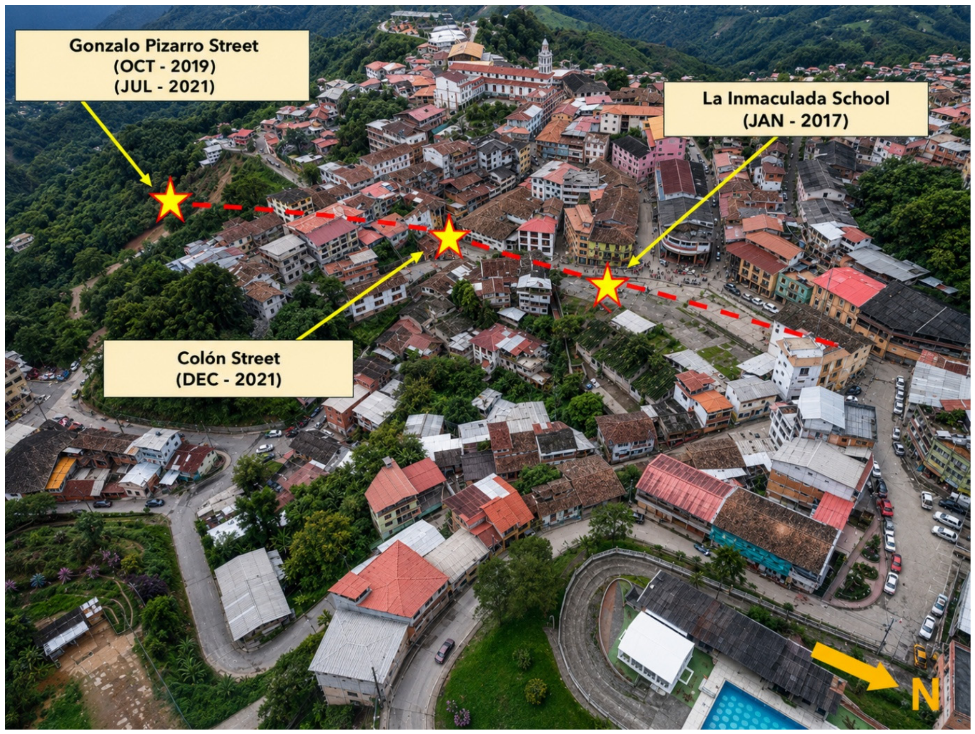
This interaction has produced differential settlement, ground cracking, sinkholes, and localized collapses within the urban area. Significant events include the collapse beneath the “La Inmaculada Fe y Alegría” school and the major sinkhole along Colón Street, both of which caused severe structural damage [
7]. Electrical Resistivity Tomography (ERT), InSAR monitoring, and underground geomechanical investigations have identified heterogeneous rock masses, altered and saturated materials, discontinuities, and shallow cavities beneath critical urban sectors [
6,
10,
11]. These observations demonstrate that the urban instability problem cannot be addressed solely by treating individual surface collapse zones, but requires remediation strategies capable of improving the mechanical condition of the underlying underground excavation network.
In response to these conditions, the Geological and Energy Research Institute of Ecuador (IIGE) conducted a multidisciplinary geological and geotechnical investigation between 2021 and 2022. The study integrated topographic monitoring, drone photogrammetry, underground laser scanning, hydrogeological characterization, geophysical surveys, and geomechanical assessment [
9]. The results identified critical sectors where shallow interconnected excavations coincide with weakened rock masses, groundwater infiltration, and surface deformation. Nevertheless, remediation has largely focused on individual collapse zones, highlighting the need for broader strategies capable of restoring underground support and limiting deformation propagation.
Cemented tailings-based backfill represents a potentially sustainable alternative because it simultaneously addresses underground void stabilization and mine-waste reutilization. Cemented paste and tailings backfill technologies have been increasingly investigated as part of sustainable and green mining strategies, with applications ranging from underground support and void filling to reduction in surface tailings disposal and associated socio-environmental impacts [
12,
13,
14]. Experiences from Andean mining districts further demonstrate the potential for incorporating locally generated mine tailings into underground backfilling systems, thereby linking geotechnical stabilization with circular-economy and mine-waste management objectives [
13]. The remediation of shallow post-mining excavations is particularly relevant in urbanized settings, where the persistence of unsupported voids may compromise overlying infrastructure and requires appropriate filling and ground-control strategies [
14,
15].
The engineering performance of cemented tailings backfill, however, depends on more than hardened compressive strength alone. Recent investigations demonstrate that tailings particle characteristics, solids concentration, binder type and dosage, water content, fresh-state fluidity, curing conditions, and microstructural development jointly control workability and mechanical performance [
16,
17,
18]. Binder selection and proportioning are particularly important because they affect strength development, stiffness, material consumption, and economic feasibility [
12,
16,
17]. At the same time, practical implementation requires consideration of mixing, transport, placement, and the capacity of the backfill to occupy irregular underground voids and establish effective mechanical interaction with the surrounding rock mass [
13,
15]. Consequently, laboratory-scale workability and hardened mechanical properties should be distinguished from demonstrated field-scale pumpability and complete backfill-to-rock contact.
Despite these advances, most cemented paste backfill studies have been developed in operating mines, where excavation geometry, access, material transport, and filling sequences can be incorporated into mine planning [
12,
13,
14,
15,
16,
17]. Considerably less attention has been given to historical urban mining districts characterized by shallow, irregular, interconnected, and partially inaccessible workings beneath existing infrastructure. Under these conditions, the engineering problem extends beyond material design and includes the spatial reconstruction of abandoned excavations, characterization of heterogeneous geological and hydrogeological conditions, identification of mechanically critical sectors, and evaluation of how backfilling modifies stress redistribution and deformation. This constitutes a particularly important knowledge gap for Zaruma, where extensive geological, geophysical, underground-mapping, and deformation information is available, but the potential mechanical response of a tailings-based backfill system has not been evaluated within an integrated numerical framework.
3. Methodology
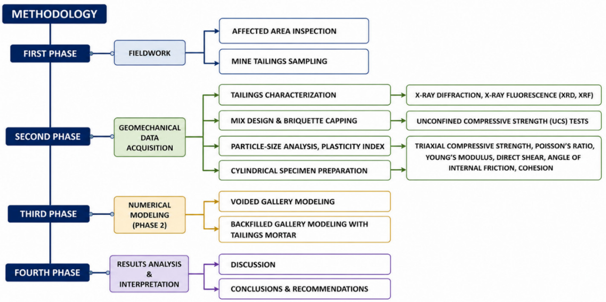
The methodological framework adopted in this study was designed to evaluate the geomechanical response of underground mining galleries beneath the urban area of Zaruma through an integrated approach combining field investigations, geotechnical characterization, laboratory testing, and pseudo-static numerical modeling. The methodology was structured into four sequential research phases aimed at characterizing the geological and geomechanical conditions of the study area (
Figure 6), evaluating the mechanical behavior of tailings-based mortar mixtures, and assessing the effectiveness of underground backfilling as a mitigation strategy against mining-induced subsidence and progressive collapse processes.
3.1. Phase I: Field Investigation and Geological–Geomechanical Characterization
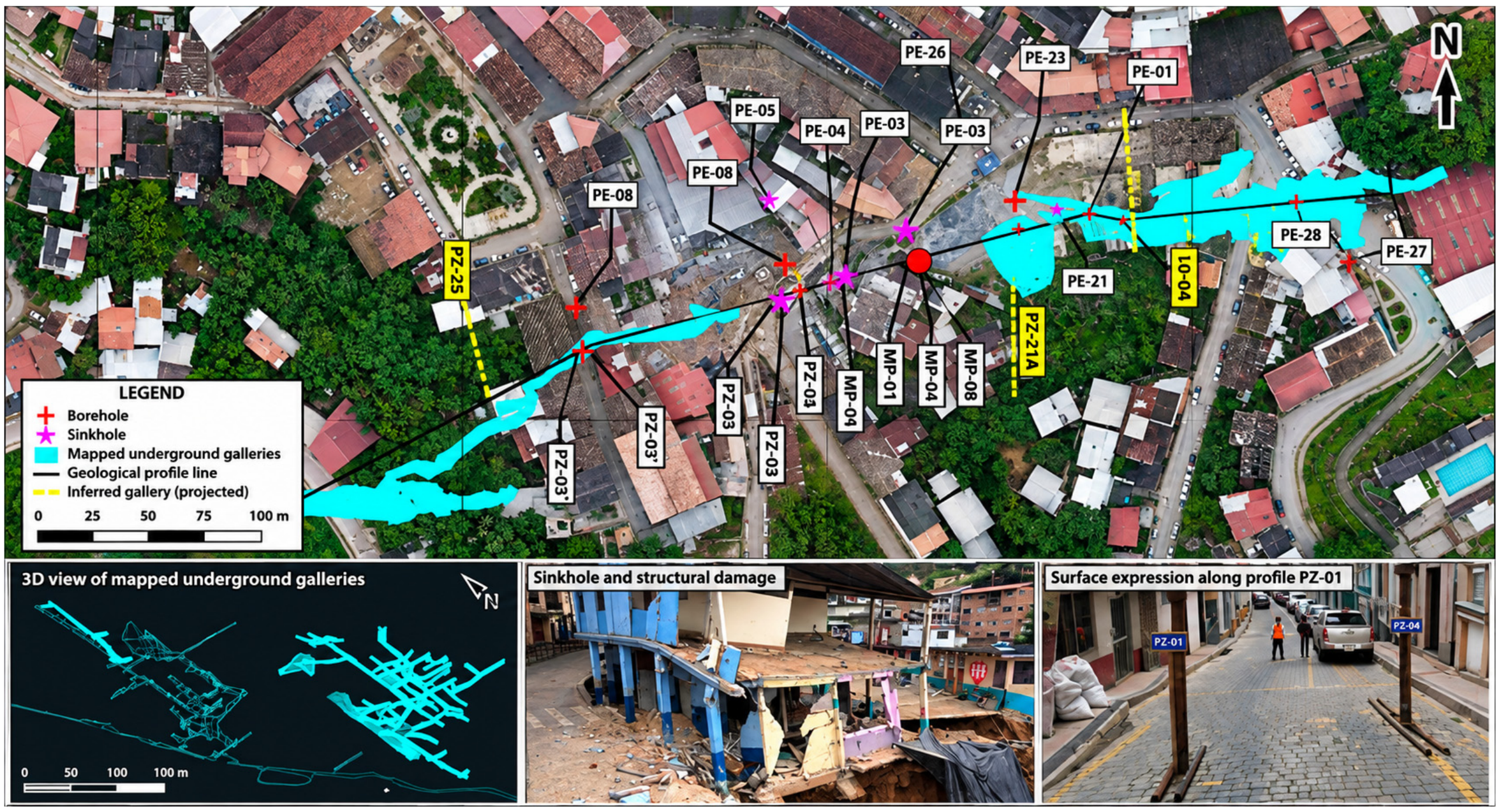
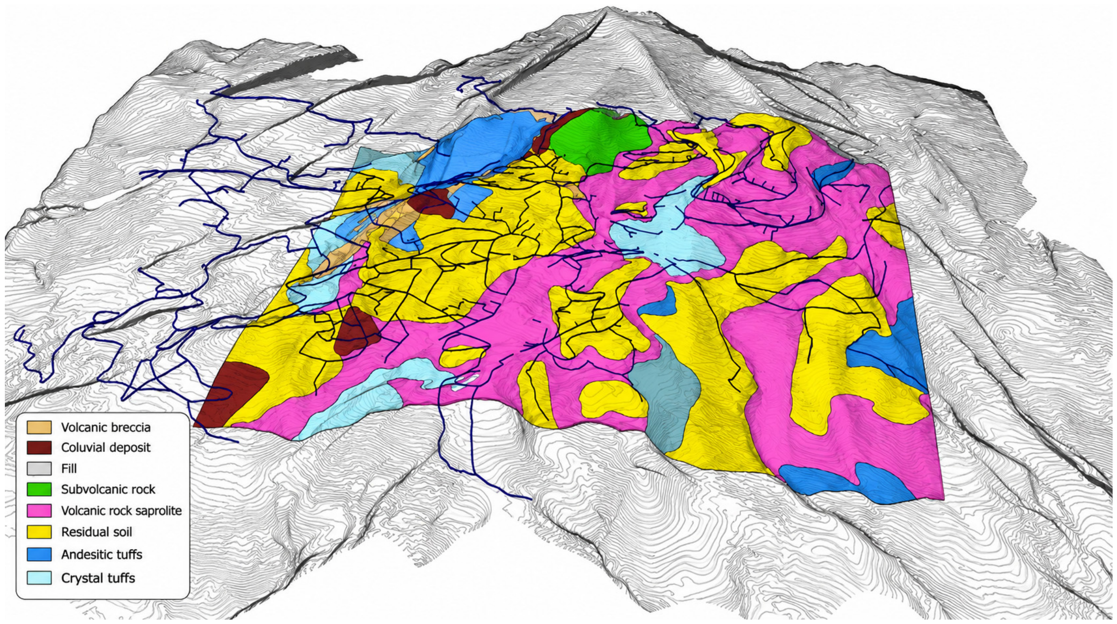
The first phase consisted of the compilation and integration of geological, geotechnical, hydrogeological, and mining information from the Zaruma–Portovelo district (
Figure 7). This stage included detailed field inspections in sectors affected by ground deformation, sinkholes, and structural damage associated with underground mining activities, particularly in the vicinity of the Colón and 10 de Agosto sectors and the “La Inmaculada Fe y Alegría” school collapse zone [
4,
9].
Field investigations were complemented using information generated by the Geological and Energy Research Institute of Ecuador (IIGE), including geological and geotechnical zoning maps, underground laser scanning surveys, geophysical investigations, and geomechanical characterization of underground galleries. The geometry and spatial distribution of underground mining excavations were interpreted through underground mapping and three-dimensional representations derived from GeoSLAM surveys and topographic data integration.
Additionally, the regional geological framework, hydrothermal alteration patterns, structural discontinuities, and hydrogeological conditions affecting the urban area were analyzed to establish the principal geological controls governing subsidence propagation and underground instability. Previous investigations based on Electrical Resistivity Tomography (ERT), InSAR monitoring, and geomechanical mapping were also integrated into the geological interpretation of the study area [
24].
3.2. Phase II: Tailings Characterization and Geomechanical Testing
The second phase comprised the physical, mineralogical, and geomechanical characterization of mine tailings and cemented tailings mortar used as engineered backfill in the numerical analyses. The experimental dataset was derived from the laboratory programs conducted by Zambrano-Silva [
25] and Burbano-Morillo et al. [
7], both specifically developed using tailings from the Zaruma–Portovelo mining district for the stabilization and closure of abandoned underground galleries.
The tailings were obtained from the El Tablón community tailings facility, which receives residues generated by gold-processing operations in the district. Representative samples were subjected to physical and mineralogical characterization before mortar preparation. The laboratory program included particle-size distribution and aggregate characterization following ASTM C637 [
26], determination of material finer than 75 μm according to ASTM C117 [
27], density and absorption according to ASTM D854 [
28], organic impurities according to ASTM C40 [
29], and chemical characterization according to ASTM C114 [
30]. The tailings exhibited an average bulk density of 1596.12 kg/m
3 and predominantly fine-grained characteristics suitable for their use as the aggregate fraction of the cemented mortar. Mineralogical and chemical analyses were used to identify the principal mineral phases and constituents associated with the processed volcanic and hydrothermally altered materials.
Cemented tailings mortars were subsequently prepared at different cement-to-tailings and water-to-cement ratios to determine a mixture providing adequate fresh-state consistency and mechanical strength for underground placement. Workability was evaluated using the mortar flow test according to ASTM C1437 [
31], while air content and compressive strength were evaluated following ASTM C185-02 [
32] and ASTM C109 [
33], respectively. Based on the experimental program, the selected formulation corresponded to a cement-to-tailings mass ratio of 1:2 (1C:2T) and a water-to-cement ratio (w/c) of 0.49, equivalent to approximately 602.10 kg/m
3 of cement, 1136.14 kg/m
3 of tailings, and 295.03 kg/m
3 of water. The mixture exhibited a fluid consistency suitable for self-leveling placement or injection in the laboratory-scale assessment and reached an unconfined compressive strength of approximately 18 MPa after 14 days of curing [
7,
25].
For the geomechanical characterization, 12 cemented-tailings mortar specimens were prepared and tested after 14 days of curing. Strength and deformability parameters were obtained from laboratory compression and triaxial testing and subsequently used to define the Mohr–Coulomb properties of the engineered backfill in the numerical model. The adopted parameters for the 1C:2T mortar were a unit weight of 19.32 kN/m
3, cohesion c = 1.361 MPa, friction angle φ = 47°, deformation modulus E = 7359 MPa, and Poisson’s ratio ν = 0.17 [
7]. These experimentally derived properties were distinguished from parameters assigned to the surrounding geological units, for which laboratory results, rock-mass characterization, Hoek–Brown-based estimates, or published values were used according to data availability.
The available experimental program did not include a complete rheological characterization in terms of yield stress, plastic viscosity, bleeding, or segregation resistance. Therefore, the present study does not interpret the ASTM C1437 [
31] flow response as direct evidence of full-scale pumpability. Instead, the experimental results demonstrate adequate laboratory-scale fluidity and mechanical performance for evaluating the cemented tailings mortar as an engineered backfill in the numerical simulations. Detailed rheological testing and full-scale pumping and injection trials are recommended prior to field implementation within the Zaruma underground gallery network.
3.3. Phase III: Pseudo-Static Numerical Modeling
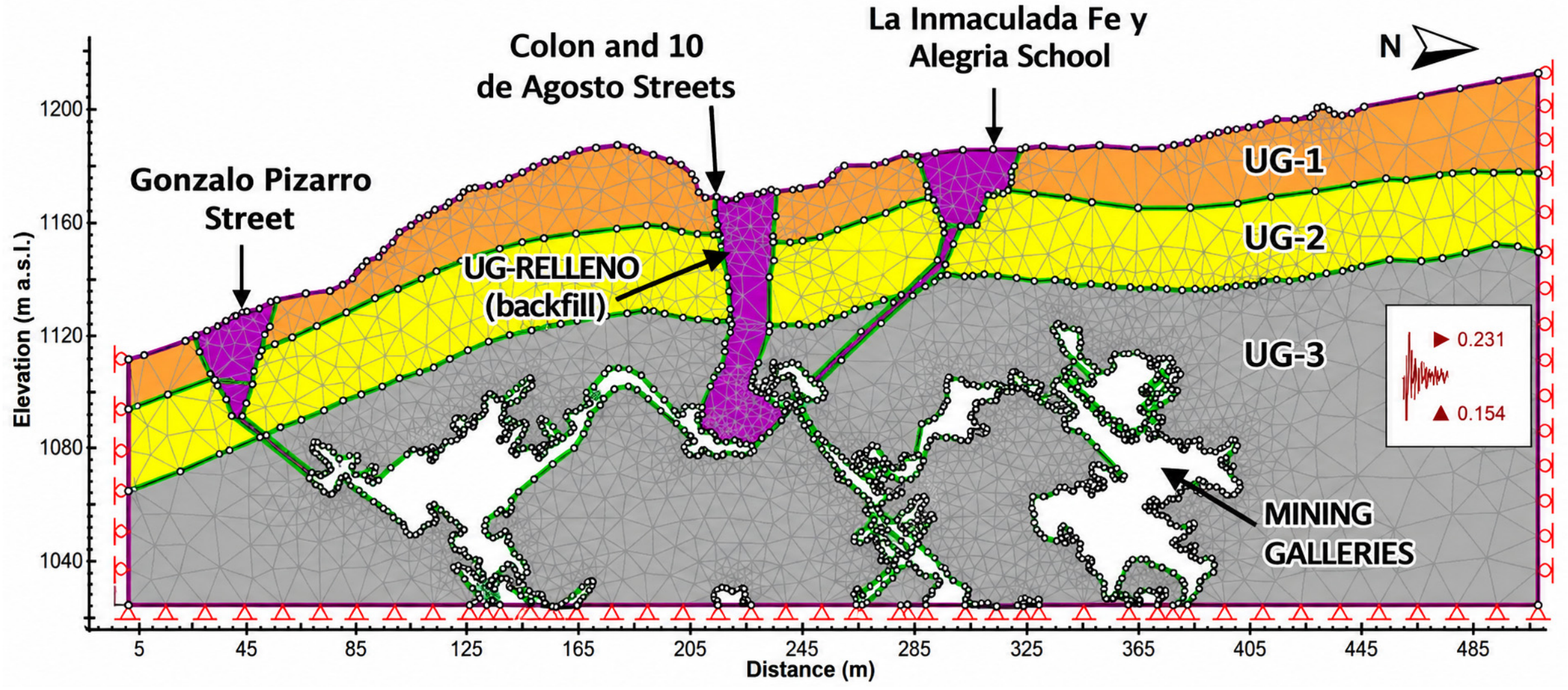
The third phase comprised the development of two-dimensional (2D) pseudo-static finite-element models using PHASE2 version 8.0 software (Rocscience) to evaluate stress redistribution, deformation, and yielding mechanisms associated with shallow underground galleries beneath the urban area of Zaruma. The numerical analysis was conceived as a representative-section geomechanical assessment rather than as a complete three-dimensional prediction of the regional subsidence field.
The location and geometry of the analyzed sections were constrained by the integrated three-dimensional interpretation of the underground mine network obtained from underground mapping, GeoSLAM laser-scanning surveys, topographic data, geological–geotechnical information, and documented instability sectors. Particular attention was given to areas where shallow excavations, reduced pillar dimensions, weakened volcanic rock masses, and historical subsidence events spatially coincide, including the Colón–10 de Agosto corridor and the former “La Inmaculada Fe y Alegría” school sector. This approach allowed the 2D models to represent geomechanically critical cross-sections of the actual underground system rather than idealized or arbitrarily selected profiles.
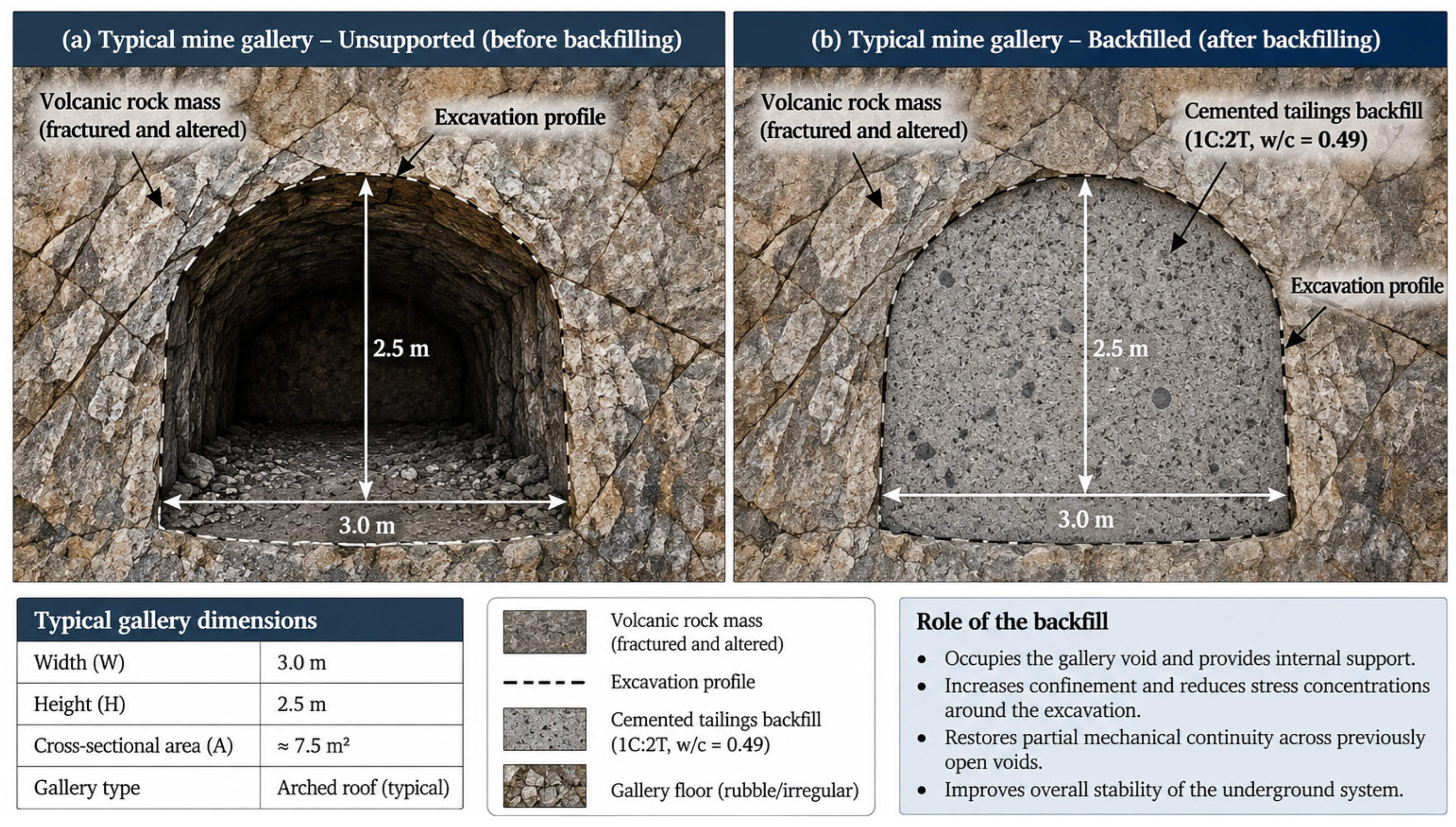
The numerical models incorporated the interpreted geological stratigraphy, excavation geometry, geomechanical properties of the surrounding rock mass, and the hardened properties of the engineered cemented tailings backfill obtained during the previous experimental phases. The geological and engineered units were represented using an elasto-plastic Mohr–Coulomb constitutive model. Two principal scenarios were evaluated under identical geometric, constitutive, boundary, and pseudo-static loading conditions: (i) the current condition characterized by open and unsupported underground galleries; and (ii) a stabilized condition in which the same excavations were represented as completely backfilled with hardened cemented tailings material (
Figure 6). This comparative framework was used to evaluate the relative influence of backfilling on confinement, stress redistribution, deformation, and yielding around the underground openings.
In the stabilized scenario, the gallery voids were completely occupied by the backfill material across the modeled cross-section. Consequently, the numerical representation assumes continuous contact between the hardened backfill and the gallery floor, sidewalls, and roof. No explicit air gap, partially filled crown zone, or discontinuous backfill–rock contact was incorporated into the baseline stabilized model. This configuration therefore represents an idealized full-filling and full-contact condition, in which the engineered backfill contributes both lateral confinement to the gallery walls and direct mechanical support to the gallery roof.
This assumption is relevant to the interpretation of the predicted stabilization response. In actual abandoned mine galleries, complete backfill-to-roof contact may be difficult to achieve because of irregular excavation geometry, inaccessible voids, entrapped air, settlement, shrinkage, bleeding, and placement limitations (
Figure 8). Under incomplete filling conditions, the initial contribution of the backfill would be expected to arise predominantly from lateral confinement of the gallery walls, whereas direct roof support would develop only after mechanical contact with the crown is established. Accordingly, the fully backfilled configuration adopted in the present study should be interpreted as a favorable upper-bound stabilization scenario, rather than as a guaranteed representation of field placement conditions.
The analyses were performed under a 2D plane-strain idealization. Accordingly, the model assumes that geometry, material properties, and mechanical response remain approximately invariant in the direction perpendicular to each analyzed section. This assumption provides a practical framework for evaluating local stress–deformation mechanisms along representative sections; however, it does not explicitly reproduce longitudinal stress transfer, three-dimensional arching, interactions among non-coplanar galleries and pillars, or the full spatial development of the surface subsidence basin. Therefore, the calculated stresses, displacements, and yielding patterns are interpreted as section-specific numerical indicators of geomechanical response and relative stabilization efficiency rather than as a complete three-dimensional prediction of ground deformation.
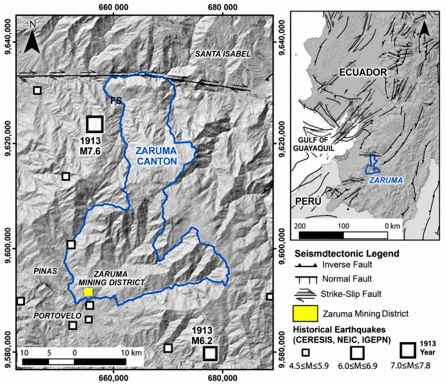
Pseudo-static seismic loading was incorporated to represent the seismotectonic conditions of southern Ecuador [
34,
35]. The numerical analyses focused on five response variables: (i) principal stress redistribution, (ii) absolute horizontal displacement, (iii) absolute vertical displacement, (iv) total displacement, and (v) yielding propagation around underground excavations. The same pseudo-static loading framework was applied to both unsupported and backfilled configurations to ensure direct comparison of their modeled mechanical response.
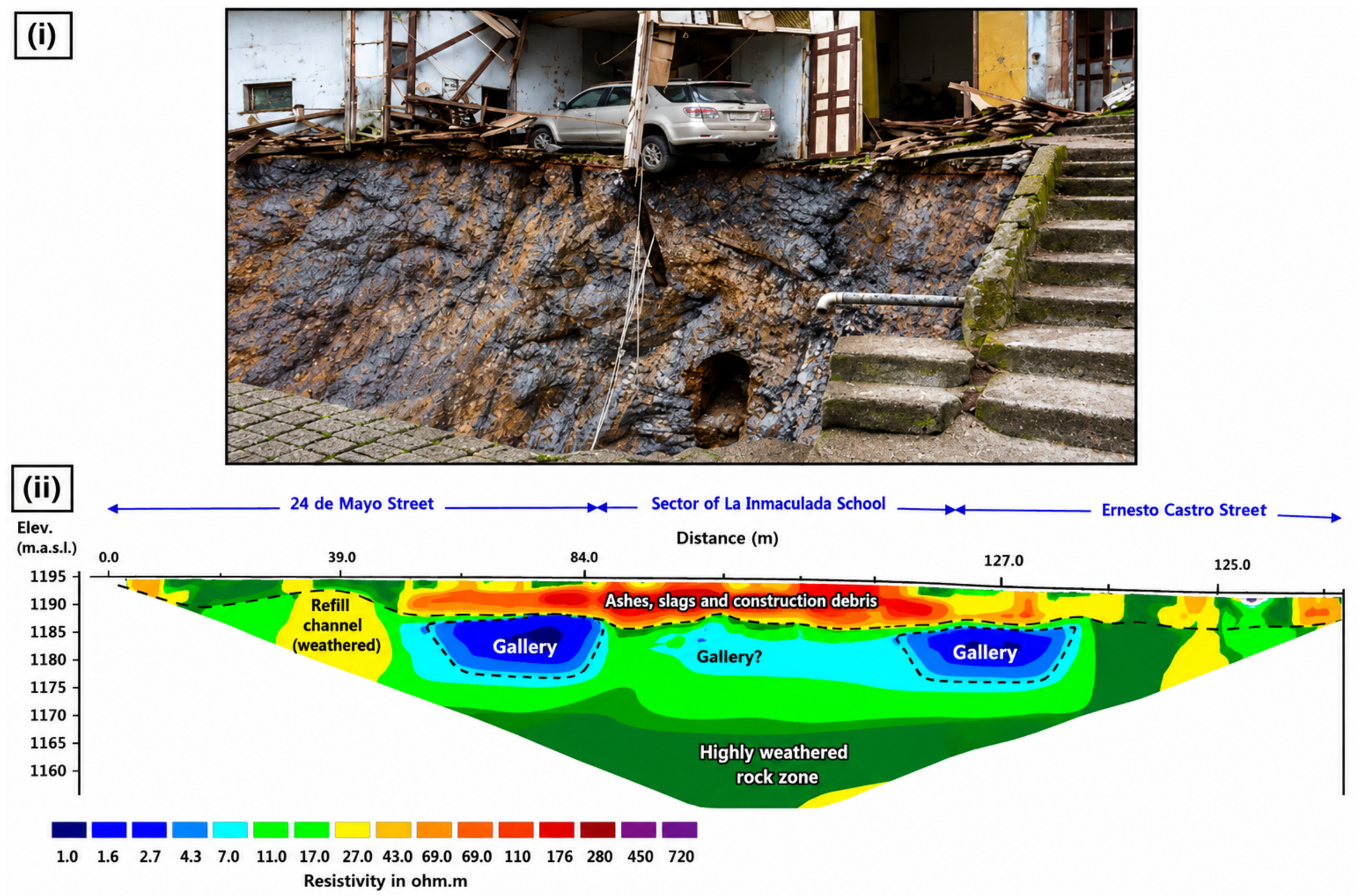
The interpretation of the 2D results was further constrained by independent geological, geophysical, and deformation evidence available for Zaruma. The selected critical sectors correspond to areas where underground mapping, historical sinkhole locations, Electrical Resistivity Tomography (ERT), field observations, and DInSAR monitoring have previously identified underground voids, fractured or altered materials, and progressive deformation (
Figure 8). This agreement provides qualitative support for the spatial relevance of the representative sections, although it does not constitute a direct 2D–3D numerical validation or a validation of the assumed complete backfill-to-roof contact.
Accordingly, the numerical framework adopted in this study should be regarded as a 3D geometry-informed, 2D mechanical analysis designed primarily to compare unsupported and backfilled gallery conditions and to identify the principal mechanisms controlling local instability. The backfilled models specifically represent an idealized complete-filling condition and therefore provide an upper-bound estimate of the potential mechanical benefit of continuous backfill contact. A fully three-dimensional numerical model incorporating longitudinal and lateral stress transfer, irregular gallery intersections, spatially variable excavation geometry, partial filling conditions, and controlled roof-gap configurations is beyond the scope of the present study and is recommended for subsequent site-specific analyses and field-scale validation.
3.4. Phase IV: Results Integration and Geomechanical Interpretation
The fourth phase consisted of the integrated interpretation of the numerical modeling results in conjunction with the geological, hydrogeological, and geomechanical conditions identified during the previous phases (
Figure 9,
Table 1). The stress distribution patterns, deformation concentrations, and yielding zones obtained from the simulations were analyzed to identify the principal instability mechanisms governing subsidence propagation beneath the urban area.
The effectiveness of tailings-based mortar injection as a stabilization strategy was evaluated by comparing the displacement and stress responses obtained for unsupported and backfilled underground galleries. The analysis emphasized the capacity of cemented tailings backfill to improve confinement conditions, reduce deformation propagation, and mitigate instability processes associated with shallow underground mining excavations.
Finally, the geomechanical implications of the results were discussed within the broader context of urban geotechnical risk, underground mining sustainability, and circular economy approaches based on mine waste reutilization. The integrated methodology developed in this study provides a multidisciplinary framework for evaluating mining-induced subsidence in urban environments affected by shallow underground excavations and structurally weakened rock masses.
4. Results
4.1. Geomechanical Characterization of Tailings-Based Mortar
The experimental characterization of the Zaruma–Portovelo mine tailings and cemented tailings mortar provided the physical and mechanical basis for defining the engineered backfill incorporated into the numerical models. The tailings investigated by Zambrano-Silva [
25] were specifically characterized for their potential reuse as raw material in mortars intended for the stabilization and closure of abandoned mining galleries in Zaruma (
Figure 9). The material was obtained from tailings generated by local gold-processing activities and exhibited predominantly fine-grained characteristics. The experimental characterization included particle-size distribution, material finer than 75 μm, density and absorption, organic impurities, and chemical and mineralogical analyses. An average bulk density of 1596.12 kg/m
3 was obtained for the tailings (
Table 1). These results supported their use as the fine aggregate fraction of the cemented mortar rather than as a conventional structural soil (
Table 1).
Different cement-to-tailings and water-to-cement proportions were experimentally evaluated to identify a mixture combining adequate fresh-state consistency with sufficient mechanical strength for gallery backfilling. Based on these tests, the selected formulation consisted of a 1:2 cement-to-tailings mass ratio (1C:2T) and a water-to-cement ratio (w/c) of 0.49, corresponding to approximately 602.10 kg/m
3 of cement, 1136.14 kg/m
3 of tailings, and 295.03 kg/m
3 of water [
7,
14,
16,
25]. Fresh-state consistency was assessed using the mortar flow test (ASTM C1437 [
31]). The selected mixture exhibited a fluid consistency compatible with the placement approach considered in the experimental studies. However, because yield stress, plastic viscosity, bleeding, and segregation resistance were not quantified, the available flow results are interpreted as evidence of laboratory-scale workability rather than as a complete demonstration of full-scale pumpability.
Mechanical testing showed that the selected 1C:2T mortar reached an unconfined compressive strength of approximately 18 MPa after 14 days of curing [
7]. This strength level provided the basis for evaluating the material as an engineered backfill capable of contributing mechanical support after placement within the underground voids (
Table 2). The result is particularly relevant for the Zaruma gallery network, where the backfill is intended not only to occupy abandoned cavities but also to contribute to confinement and stress transfer between the surrounding rock mass and the cemented fill.
The constitutive parameters assigned to the cemented tailings backfill were derived from the experimental geomechanical characterization reported by Burbano-Morillo et al. [
7]. A total of 12 mortar specimens were evaluated, and the 14-day 1C:2T mortar was characterized by a unit weight of 19.32 kN/m
3, cohesion c = 1.361 MPa, friction angle φ = 47°, deformation modulus E = 7359 MPa, and Poisson’s ratio ν = 0.17. These properties were adopted for the Mohr–Coulomb representation of the engineered backfill in the finite-element analyses (
Table 2). Unlike some parameters assigned to the surrounding geological units, which were obtained from rock-mass criteria, correlations, or published values where direct measurements were unavailable, the parameters assigned to the cemented tailings mortar were based on the laboratory characterization of the engineered material.
In general, the experimental results indicate that the selected 1C:2T mixture combines measurable laboratory-scale flowability with relatively high short-term mechanical strength and stiffness. These characteristics support its use in the present study as a mechanically competent backfill for assessing stress redistribution and deformation reduction in abandoned galleries. Nevertheless, the experimental program did not include a complete rheological assessment or full-scale pumping and injection trials. Therefore, the results demonstrate the geomechanical suitability of the mortar for the numerical stabilization scenarios evaluated herein, whereas field-scale transport, pumping, injection pressure, bleeding, segregation, and placement performance should be verified through additional rheological and pilot-scale testing prior to large-scale implementation.
4.2. Geological–Geotechnical Model of the Zaruma Subsurface
The integrated subsurface model developed for the Zaruma urban sector reveals a highly heterogeneous underground environment controlled by the interaction between altered volcanic lithologies, structurally controlled epithermal vein systems, shallow mining excavations, and hydrogeological processes associated with fractured rock masses. The resulting geological–geotechnical configuration constitutes the principal controlling factor governing deformation propagation and the development of mining-induced subsidence beneath the city.
The underground framework is dominated by volcanic and volcano-sedimentary sequences associated with the Oligocene–Miocene magmatic arc of southwestern Ecuador [
22]. These units are affected by intense hydrothermal alteration, regional faulting, and pervasive discontinuity networks that significantly influence the mechanical response of the rock mass. Geological investigations performed in the Zaruma–Portovelo district indicate that the mineralized structures are primarily controlled by fault systems and fracture corridors that guided both hydrothermal circulation and subsequent underground mining development [
36].
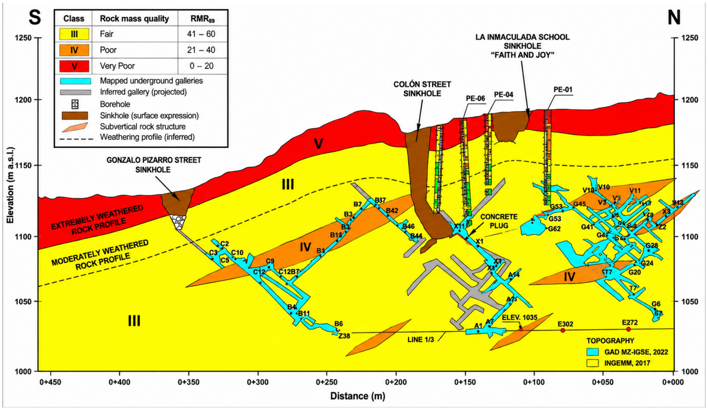
The subsurface interpretation generated in this study was constructed from the integration of underground gallery mapping, topographic information, geological observations, geophysical investigations, and geomechanical characterization performed in previous technical studies developed by the IIGE [
9] within the Zona de Exclusión Minera (
Figure 7). The model incorporates the spatial distribution of underground excavations associated with the Tres Reyes vein system and adjacent mining sectors located beneath densely urbanized areas of Zaruma Canton.
The interpreted geological profile indicates that the underground galleries are developed within intensely fractured volcanic materials characterized by highly variable degrees of weathering and alteration. In several sectors, the rock mass exhibits evidence of argillic alteration, oxidation, silicification, and structural weakening associated with prolonged hydrothermal activity [
23]. These alteration processes considerably reduce the strength and stiffness of the host rock, favoring localized instability and progressive deformation around underground openings.
A critical characteristic of the underground system is the reduced depth of numerous mining galleries beneath the urban area. Several excavations occur immediately below residential neighborhoods, public infrastructure, and historically significant buildings, resulting in highly unfavorable conditions for long-term surface stability. The spatial relationship between shallow excavations and urban loading conditions strongly contributes to differential settlement development and the upward migration of failure mechanisms toward the ground surface.
The geotechnical configuration identified in the study area reflects cumulative degradation produced by decades of uncontrolled underground mining activity. Historical excavations progressively modified the original confinement conditions of the rock mass through the extraction of support pillars and the expansion of interconnected gallery systems beneath the city. As a consequence, the underground environment currently exhibits discontinuous confinement conditions, stress concentration sectors, and localized zones susceptible to progressive yielding. Hydrogeological conditions further intensify the instability processes affecting the underground system. According to the IIGE investigations, groundwater circulation is strongly controlled by fracture systems and altered lithological contacts, generating preferential infiltration pathways and localized moisture accumulation zones beneath the urban area. The infiltration of water through fractured volcanic materials promotes weathering acceleration and reduction in effective stress conditions around underground openings, increasing susceptibility to deformation and collapse propagation.
The geophysical investigations performed in Zaruma provided important validation for the geological–geotechnical interpretation developed in this study. Electrical Resistivity Tomography (ERT) profiles identified anomalous sectors characterized by low resistivity values associated with fractured materials, underground voids, moisture accumulation, and altered volcanic units beneath critical urban sectors. Similar geophysical signatures have been reported in mining districts affected by subsidence and shallow underground instability, where low-resistivity anomalies commonly correspond to fractured and saturated sectors surrounding underground excavations [
10].
Based on lithology, alteration degree, rigidity, and deformational behavior, four principal geotechnical units were defined within the numerical model. These units range from low-rigidity clayey and saprolitic materials near the surface to moderately competent volcanic rock hosting the underground excavations. Additionally, specific geotechnical units corresponding to previously executed backfill sectors and tailings-based mortar mixtures were incorporated into the pseudo-static simulations.
The conceptual subsurface model also indicates that instability mechanisms beneath Zaruma are spatially concentrated in sectors where multiple adverse factors converge simultaneously, including: (i) shallow excavation depth, (ii) reduced pillar thickness, (iii) structurally weakened volcanic rocks, (iv) groundwater infiltration, and (v) dense urban loading. These sectors coincide with the locations of the most significant collapse events historically documented in the city, including the failures associated with the “La Inmaculada Fe y Alegría” school and Colón Street.
Satellite deformation monitoring studies conducted in Zaruma using Differential Interferometric Synthetic Aperture Radar (DInSAR) techniques further support the interpretation of progressive deformation processes affecting the urban area. Cando Jácome et al. [
24] and Ammirati et al. [
6] demonstrated that several sectors of the city exhibit measurable surface deformation associated with underground mining activity and progressive subsurface instability. These investigations confirmed that deformation is not restricted to isolated sinkhole sectors, but rather affects broader portions of the urban environment through gradual subsidence mechanisms.
The integrated geological–geotechnical model developed in this study demonstrates that the subsurface beneath Zaruma behaves as a coupled hydrogeological–geomechanical system affected by long-term anthropogenic disturbance and progressive structural degradation. Under these conditions, the stability of the urban area is controlled not only by the geometry of the underground excavations, but also by the combined influence of alteration intensity, discontinuity persistence, groundwater circulation, and stress redistribution within the fractured volcanic rock mass. This conceptual framework provided the basis for the pseudo-static numerical simulations presented in the following sections, allowing the evaluation of deformation concentration zones, displacement propagation mechanisms, and the effectiveness of tailings-based mortar backfilling for underground stabilization beneath Zaruma Canton.
4.3. Numerical Modeling of Current Underground Conditions
The pseudo-static numerical analyses of the current unsupported underground configuration revealed pronounced stress concentrations, localized deformation, and progressive yielding around shallow galleries and remnant rock pillars beneath the analyzed sectors of Zaruma. These results characterize the mechanical response of the selected representative 2D sections under the plane-strain assumptions described in
Section 3.3 and should therefore be interpreted as section-specific indicators of geomechanical instability rather than as a complete three-dimensional prediction of surface subsidence.
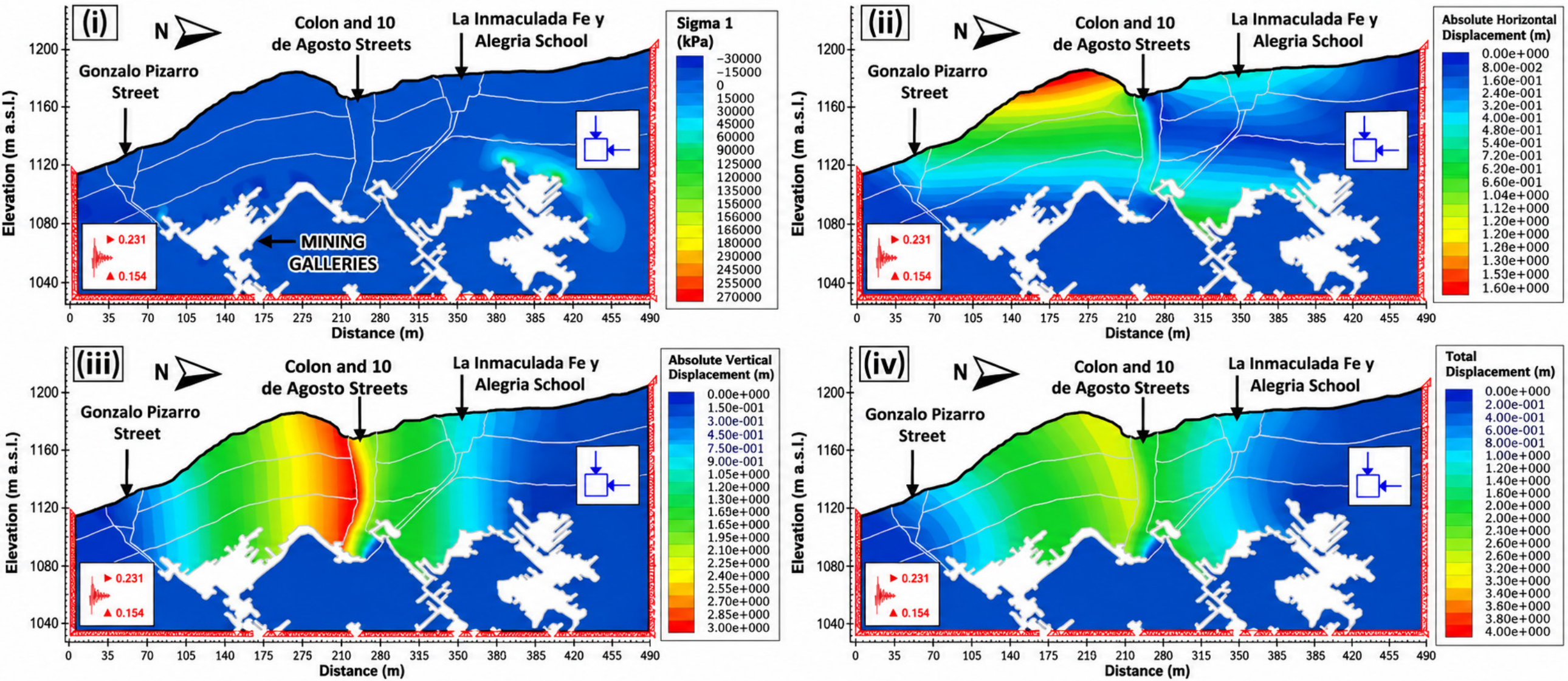
The principal stress distribution showed a strongly heterogeneous response around the underground openings. Maximum principal stresses locally reached approximately 86.5 MPa, particularly around gallery crowns, excavation boundaries, and sectors characterized by reduced pillar thickness. These localized concentrations indicate substantial stress redistribution associated with the loss of confinement produced by the interconnected underground voids. In contrast, lower stress levels occurred within the open cavities and adjacent weakened materials, generating pronounced stress gradients between unsupported excavations and the surrounding rock mass.
The modeled stress concentrations were particularly evident where shallow excavations intersect fractured and hydrothermally altered volcanic materials. Under pseudo-static loading, these sectors developed localized zones of elevated stress and yielding, indicating that the combination of reduced confinement, weakened rock-mass properties, and seismic inertial loading can promote progressive mechanical degradation around the underground openings. The resulting patterns are consistent with the conceptual geomechanical model developed from underground mapping, geological–geotechnical characterization, and the spatial distribution of historically documented instability sectors.
The horizontal displacement field exhibited localized numerical values ranging from approximately 0.2 to 2.6 m, with the largest magnitudes concentrated around shallow excavations and mechanically weakened sectors. Vertical displacements locally approached 2.8 m, particularly above and adjacent to galleries characterized by reduced overburden thickness and limited rock support. The combined displacement field resulted in localized total displacement magnitudes approaching 4 m in the most critical portions of the analyzed sections.
These relatively large displacement values require careful interpretation within the limitations of the numerical framework. They represent localized 2D numerical deformation within the modeled rock mass and should not be interpreted as direct measurements or predictions of surface settlement at Zaruma. In particular, the plane-strain formulation does not reproduce out-of-plane load transfer, longitudinal arching, interaction among non-coplanar galleries, or the complete three-dimensional surface displacement field. Consequently, the modeled displacement magnitudes are used primarily to identify critical deformation zones and to establish a consistent baseline for comparison with the backfilled configurations, rather than to predict absolute urban subsidence.
The displacement vectors indicate preferential deformation toward unsupported openings and structurally weakened zones between adjacent galleries. Within the analyzed sections, these patterns suggest progressive loss of mechanical continuity in the intervening rock mass, particularly where reduced pillars coincide with fractured or altered materials [
37,
38] (
Figure 9). The numerical response therefore identifies potential pathways for local deformation propagation from underground openings toward shallower levels. However, because the analyses are two-dimensional, lateral or longitudinal propagation outside the modeled section cannot be quantified.
The spatial relevance of the modeled critical sectors is supported qualitatively by independent evidence from the Zaruma urban area. Historical sinkholes, field observations, underground mapping, Electrical Resistivity Tomography (ERT), and DInSAR monitoring have identified deformation and subsurface anomalies within or adjacent to the same critical urban sectors represented by the numerical sections [
39,
40,
41,
42] (
Table 3). The correspondence between these independent observations and the modeled zones of elevated stress, displacement, and yielding supports the proposed geomechanical interpretation, although it does not constitute a quantitative validation of the absolute displacement magnitudes or a direct 2D–3D numerical validation.
Therefore, the unsupported-gallery simulations indicate that the representative sections are characterized by substantial confinement loss, stress concentration, localized deformation, and progressive yielding under pseudo-static conditions (
Figure 10). Within the scope of the 2D analysis, these results establish a mechanically consistent baseline condition against which the relative effectiveness of cemented tailings backfill can be evaluated. The subsequent stabilized scenarios therefore focus on changes in stress concentration, displacement intensity, and yielding obtained under the same geometry, constitutive assumptions, boundary conditions, and pseudo-static loading framework.
4.4. Numerical Modeling of Backfilled Galleries
The second numerical scenario evaluated the geomechanical response of the underground gallery system after incorporation of hardened cemented tailings backfill within the modeled excavations. As defined in
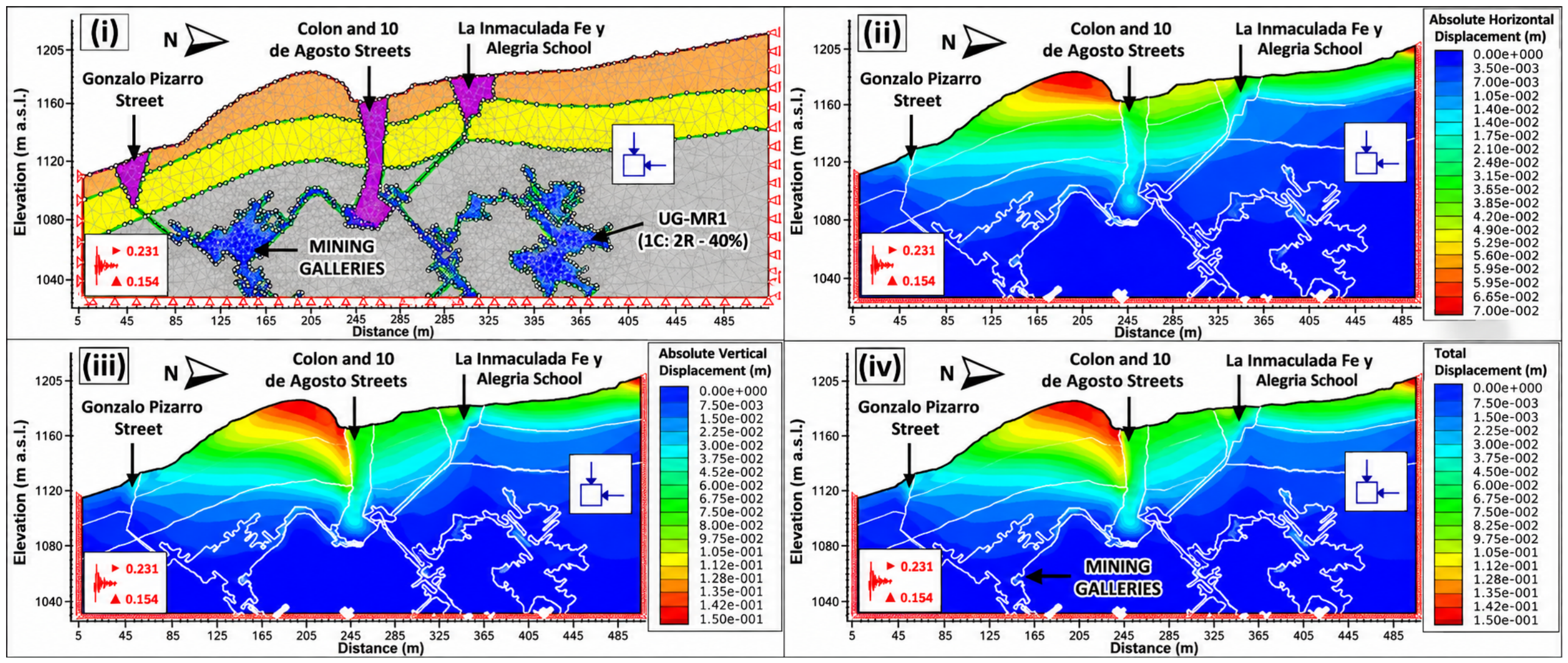
Section 3.3, the stabilized models represent an idealized complete-filling condition, in which the gallery voids are entirely occupied by the backfill and continuous numerical contact is established with the gallery floor, sidewalls, and roof (
Figure 10). No residual crown gap or partially filled zone was incorporated in this baseline scenario. Consequently, the modeled response represents a favorable upper-bound stabilization condition in which the hardened backfill contributes through both lateral confinement and direct mechanical interaction with the gallery roof.
The backfill scenarios were defined using the hardened-state mechanical properties obtained from the experimental characterization described in
Section 4.1 and summarized in
Table 1 and
Table 2. Accordingly, the finite-element analyses represent the post-curing mechanical response of the cemented backfill rather than its fresh-state transport or placement behavior. The water-to-cement ratio and fresh-state flow characteristics were therefore not used as constitutive parameters in the numerical model.
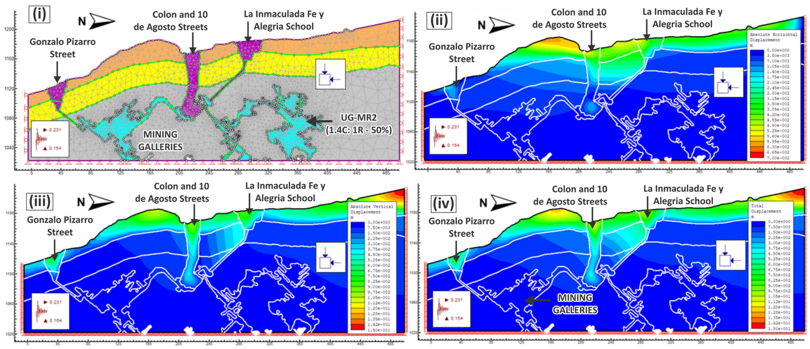
Two cemented tailings mortar formulations previously investigated by Zambrano-Silva [
25] and Burbano-Morillo et al. [
7] were considered in the backfilled-gallery scenarios. For consistency throughout the manuscript, the mixtures are designated as MR-1 and MR-2 using T = tailings. The modeled backfill properties correspond to hardened-state geomechanical parameters derived from laboratory characterization. In particular, the selected 1C:2T mortar used for detailed experimental characterization exhibited a unit weight of 19.32 kN/m
3, cohesion c = 1.361 MPa, friction angle φ = 47°, deformation modulus E = 7359 MPa, and Poisson’s ratio ν = 0.17 after 14 days of curing [
7]. These parameters were assigned to the engineered backfill using the Mohr–Coulomb constitutive model.
Under the complete-filling condition, incorporation of the cemented tailings backfill produced a marked modification of the stress field surrounding the modeled underground openings. Under the unsupported condition, maximum principal stresses locally reached approximately 86.5 MPa, with concentrations particularly evident around gallery crowns, excavation boundaries, and reduced rock pillars. In the fully backfilled scenario, maximum modeled principal stresses decreased to values close to 10 MPa, accompanied by a more distributed stress field within the engineered fill and surrounding rock mass. This response indicates that, under the assumed full-contact configuration, the hardened backfill reduces localized stress amplification and improves confinement around the excavations. The magnitude of this reduction should therefore be interpreted specifically within the complete-filling assumption rather than as a guaranteed response under partial field filling. The original manuscript reports this approximately 86.5-to-10 MPa reduction for the backfilled configuration.
The stress redistribution observed in the stabilized models reflects two mechanically complementary contributions of the fully contacted backfill. First, contact with the gallery sidewalls provides lateral confinement, restricting inward deformation of the excavation boundaries. Second, contact with the gallery crown allows the hardened backfill to participate in direct roof support and load transfer across the previously open void. Whereas the unsupported configuration concentrates stresses within narrow rock bridges and remnant pillars, the complete-contact configuration provides mechanical continuity across the gallery cross-section, thereby reducing stress gradients and localized yielding. Similar confinement and load-transfer mechanisms have been reported for cemented backfill systems in underground mining environments [
14,
16,
17,
39,
40,
41,
42].
The displacement response showed a similarly pronounced improvement under the complete-filling scenario. Under unsupported conditions, the numerical models exhibited horizontal displacements of up to approximately 2.6 m, vertical displacements locally approaching 2.8 m, and total displacements close to 4 m in the most critical sectors. These values represent localized 2D numerical deformation associated with severe underground instability rather than direct measurements or predictions of three-dimensional surface settlement. In the fully backfilled models, horizontal, vertical, and total displacement fields were markedly reduced, particularly around shallow galleries and sectors characterized by reduced pillar thickness.
The pronounced displacement reduction is consistent with the assumed continuous backfill–rock contact. Because the modeled fill simultaneously restrains lateral convergence and interacts mechanically with the gallery roof, the stabilized configuration represents the maximum support contribution considered in the present analysis. Therefore, the displacement reduction should be regarded as an upper-bound estimate of stabilization performance for the modeled material and geometry. If a residual void remains between the backfill surface and the gallery crown, direct roof support would not initially develop, and the mechanical response would be governed predominantly by lateral confinement until roof contact occurs. Under such conditions, stress and displacement reductions may be smaller than those predicted by the present complete-contact models.
The displacement vectors further indicate that, within the fully backfilled configuration, the engineered material restricts relative movement between adjacent excavation boundaries and reduces deformation concentration within the intervening rock mass. In the unsupported configuration, deformation preferentially propagated through fractured and altered zones connecting nearby openings. After complete backfilling, the deformation field became more spatially uniform, indicating improved mechanical continuity within the analyzed sections. These results describe the response of the idealized fully contacted configuration and should not be extrapolated directly to incompletely filled galleries.
A similar response was observed in the distribution of yielded elements. Under unsupported conditions, plastic zones developed preferentially around gallery crowns, excavation boundaries, and weakened rock pillars and showed a tendency to extend toward shallower sectors. Under the complete-contact backfilled condition, the spatial extent of yielding was substantially reduced, particularly in areas previously characterized by localized stress concentration. The simulations therefore indicate that a mechanically competent backfill in continuous contact with the excavation boundaries can reduce progressive yielding and improve confinement within the modeled sections.
The assumption of complete gallery filling represents an important limitation when extrapolating these results to field implementation. Abandoned mine galleries in Zaruma exhibit irregular geometries, and complete backfill-to-roof contact may be difficult to achieve because of inaccessible voids, entrapped air, placement constraints, settlement, shrinkage, bleeding, or local variations in gallery geometry. These processes were not explicitly simulated. Consequently, the present analyses do not distinguish quantitatively between the contribution of lateral wall confinement and that of direct roof support. Additional numerical sensitivity analyses considering different filling ratios and controlled crown-gap dimensions would be required to quantify these mechanisms separately and determine the extent to which the predicted reductions in stress and deformation are maintained under incomplete-filling conditions.
The numerical results should also be interpreted separately from the fresh-state placement behavior of the cemented tailings mortar. The simulations evaluate the mechanical effectiveness of the hardened backfill after placement and curing; they do not simulate fresh-state flow, pipeline transport, pumping pressure, penetration into fractures, bleeding, segregation, shrinkage development, or groundwater-flow modification. Consequently, the improvements obtained numerically should not be interpreted as evidence of full-scale pumpability, injectability, or complete field filling. The ASTM C1437 flow assessment discussed in
Section 3.2 and
Section 4.1 provides evidence of laboratory-scale workability, whereas field-scale placement within the irregular Zaruma gallery network requires additional rheological characterization and pilot-scale placement trials.
Within these limitations, the pseudo-static simulations demonstrate that complete replacement of the modeled underground voids by mechanically competent hardened cemented tailings backfill substantially improves the geomechanical response of the representative Zaruma sections. The modeled benefits include reduced stress concentration, lower displacement magnitudes, reduced yielding, and improved load transfer across previously unsupported excavations. However, these results correspond specifically to the idealized full-filling and full-contact condition and should therefore be interpreted as an upper-bound estimate of potential stabilization performance. The response under partial filling and residual roof-gap conditions remains to be quantified through dedicated sensitivity analyses before field-scale stabilization performance can be established.
4.5. Comparative Assessment of Unsupported and Backfilled Gallery Conditions
The comparative evaluation between unsupported underground galleries and stabilized backfilled conditions revealed substantial differences in the geomechanical behavior of the subsurface beneath Zaruma. The numerical simulations demonstrate that the incorporation of cemented tailings mortar produces a marked reduction in stress concentration, deformation intensity, and progressive yielding within the fractured volcanic rock mass, significantly improving the stability response of sectors affected by shallow underground excavations.
Figure 9 and
Figure 10 illustrate the contrast between the current underground configuration characterized by open voids and the stabilized condition achieved after mortar injection within the gallery system. The comparative analyses indicate that unsupported excavations generate highly heterogeneous deformation patterns associated with localized confinement loss and stress redistribution around crown sectors and remnant support pillars (
Figure 11). In contrast, the backfilled models exhibit a more uniform mechanical response characterized by reduced deformation gradients and improved stress transfer throughout the underground environment.
One of the most significant differences observed between the two scenarios corresponds to the reduction in total displacement within the underground system. Under unsupported conditions, deformation concentrations developed preferentially around shallow galleries located beneath critical urban sectors, producing progressive yielding patterns consistent with subsidence propagation mechanisms [
43]. After the implementation of the cemented backfill, the displacement fields became substantially less concentrated, indicating improved mechanical continuity and reduced susceptibility to localized failure development.
The comparative displacement analysis further demonstrates that the engineered mortar contributes to stabilizing the interaction between adjacent excavations. In the unsupported models, deformation propagation occurred through structurally weakened sectors located between nearby galleries, favoring stress transfer and progressive deterioration of the intervening rock mass. Following mortar injection, the numerical response indicates that these interaction mechanisms were considerably attenuated due to the restoration of partial confinement conditions within the underground system.
The yielding distributions obtained from the pseudo-static simulations also exhibit substantial differences between both configurations. Under current underground conditions, extensive plastic zones developed around excavation boundaries and within sectors affected by hydrothermal alteration and reduced pillar thickness. These yielding sectors showed upward propagation tendencies toward shallow urbanized zones, suggesting elevated susceptibility to progressive collapse and sinkhole formation. Conversely, the stabilized models revealed a notable reduction in the spatial extent of yielding, particularly around crown sectors and structurally weakened areas surrounding the underground openings.
The comparative stress redistribution patterns indicate that the cemented tailings mortar effectively modifies the mechanical behavior of the subsurface by reducing localized stress amplification around unsupported cavities. In the unsupported scenario, principal stresses were concentrated within narrow confinement sectors adjacent to the excavations, promoting instability development and progressive degradation of the surrounding volcanic rock mass. After backfilling, the stress distribution became more homogeneous due to the participation of the engineered fill in load transfer mechanisms, thereby reducing the intensity of localized stress accumulation.
The mechanical improvement observed in the stabilized models is particularly relevant considering the geological and hydrogeological conditions identified by the IIGE investigations within the Zona de Exclusión Minera (ZEM). The underground environment beneath Zaruma is characterized by fractured and altered volcanic materials affected by groundwater infiltration and discontinuity-controlled weakening. Under these conditions, unsupported excavations promote rapid confinement degradation and progressive instability propagation, whereas the incorporation of cemented fill materials partially restores mechanical continuity within the underground system.
The comparative simulations also suggest that the effectiveness of the stabilization system is strongly influenced by gallery geometry and excavation depth. The most significant reductions in deformation were obtained in sectors where the mortar achieved greater continuity between adjacent underground openings and where the engineered fill improved confinement beneath shallow urbanized zones. This behavior is consistent with previous investigations performed in underground mining environments where cemented backfill systems have demonstrated the capacity to reduce displacement propagation and improve excavation stability through confinement enhancement and stress redistribution [
44,
45].
An important aspect identified during the comparative analyses is the influence of hydrothermally altered sectors on the stability response of the underground system. In the unsupported models, deformation concentration tended to localize preferentially within altered volcanic materials exhibiting reduced stiffness and elevated discontinuity persistence. After stabilization, the mortar injection reduced the sensitivity of these sectors to progressive yielding by increasing confinement conditions around the underground cavities and limiting deformation propagation through fractured zones.
The numerical response obtained from the backfilled configuration is also consistent with previous geophysical investigations performed in Zaruma. Electrical Resistivity Tomography (ERT) profiles developed by the IIGE [
9] identified several low-resistivity anomalies associated with underground cavities, fractured materials, and moisture accumulation beneath unstable urban sectors. The comparative simulations indicate that the reduction in underground void connectivity through mortar injection may contribute to decreasing groundwater circulation and limiting further deterioration within these structurally weakened sectors.
The integrated interpretation of
Figure 11 and
Figure 12 demonstrates that the current underground configuration beneath Zaruma represents a highly unstable geomechanical environment susceptible to progressive subsidence and collapse propagation. The stabilization scenarios, however, indicate that the implementation of cemented tailings mortar substantially improves the underground response by reducing deformation intensity, limiting yielding propagation, and improving load redistribution within the fractured volcanic rock mass. These findings confirm that the proposed backfilling methodology constitutes a technically effective stabilization strategy for mitigating underground instability beneath the urban area of Zaruma. Moreover, the results demonstrate that the reutilization of mining tailings as engineered fill material provides a viable approach for integrating geotechnical remediation and sustainable mine waste management within historically impacted urban mining environments.
5. Discussion
The results of this investigation indicate that mining-induced instability beneath Zaruma is governed by the interaction between anthropogenic excavation and unfavorable geological and hydrogeological conditions. The shallow underground gallery network, progressive reduction in remnant support pillars, fractured and hydrothermally altered volcanic rocks, groundwater infiltration, and urban loading collectively define a mechanically weakened subsurface environment. Within this framework, uncontrolled underground excavation and loss of confinement constitute the dominant anthropogenic destabilizing mechanisms, whereas alteration, fracturing, weathering, groundwater circulation, excavation depth, and surface loading act as predisposing and contributing factors that influence the location and propagation of deformation.
The pseudo-static simulations of the unsupported configuration showed pronounced stress concentrations around gallery crowns, excavation boundaries, and reduced rock pillars, together with localized yielding and large section-specific displacements. Maximum principal stresses locally reached approximately 86.5 MPa, while horizontal, vertical, and total numerical displacements approached 2.6 m, 2.8 m, and 4.0 m, respectively, within the most critical modeled sectors. These displacement values should not be interpreted as direct measurements or predictions of three-dimensional surface settlement. Rather, they represent localized deformation within the selected 2D plane-strain sections and are primarily useful for identifying critical instability zones and establishing a consistent baseline for comparison with the backfilled configurations.
The spatial relevance of the modeled critical sectors is supported by independent observations. Previous investigations in Zaruma identified fractured and altered volcanic materials, moisture accumulation, underground cavities, and surface deformation through field inspections, underground mapping, ERT surveys, and DInSAR monitoring. The correspondence between these observations and the modeled zones of elevated stress, displacement, and yielding provides qualitative support for the proposed geomechanical interpretation. However, such correspondence should not be considered a quantitative validation of the absolute numerical displacement magnitudes or a direct validation against a three-dimensional mechanical model. The available evidence instead confirms that the selected representative sections intersect sectors already recognized as geotechnically critical.
The backfilled scenarios produced a markedly different mechanical response; however, their interpretation requires consideration of the backfill geometry adopted in the numerical model. As defined in
Section 3.3, the stabilized configuration represents an idealized complete-filling condition, in which the modeled gallery void is entirely occupied by hardened cemented tailings backfill and continuous numerical contact is established with the floor, sidewalls, and roof. Under this configuration, maximum principal stresses decreased from approximately 86.5 MPa to values close to 10 MPa, accompanied by marked reductions in displacement and yielding. These results therefore represent the mechanical response of a fully backfilled and fully contacted gallery rather than the expected response of any partially filled field configuration. The original manuscript reports this pronounced reduction in stress and deformation for the stabilized models.
The mechanical improvement observed under complete filling can be interpreted as the combined contribution of lateral confinement and direct roof support. Contact between the hardened backfill and the gallery sidewalls restricts inward deformation and modifies stress redistribution around the excavation, whereas contact with the crown allows the fill to participate directly in vertical load transfer. In the unsupported configuration, stresses are concentrated around gallery crowns, excavation boundaries, and remnant pillars. In contrast, continuous backfill contact provides mechanical continuity across the previously open gallery cross-section, resulting in a more distributed stress field and reduced localized yielding. Similar confinement and load-transfer mechanisms have been described for cemented mine backfill systems [
12,
13,
17,
18,
46,
47,
48].
The complete-contact assumption is particularly important when interpreting the magnitude of the modeled stabilization response. In abandoned and irregular underground galleries, continuous backfill-to-roof contact may not always be achieved because of variations in gallery geometry, inaccessible voids, entrapped air, settlement, shrinkage, bleeding, and placement constraints. If a residual gap remains between the upper surface of the backfill and the gallery crown, the initial stabilizing contribution would be dominated by lateral confinement, while direct vertical support of the roof would develop only after contact is established. Consequently, the reductions in stress, displacement, and yielding obtained in the present fully contacted models should be interpreted as a favorable upper-bound estimate of potential stabilization performance, rather than as a guaranteed field response.
The comparative nature of the numerical framework nevertheless provides useful information regarding the potential mechanical role of cemented tailings backfill. Both unsupported and fully backfilled scenarios were evaluated using the same representative section geometry, constitutive assumptions, boundary conditions, and pseudo-static loading framework. Consequently, the principal contribution of the analyses lies in the relative change in geomechanical response between these two limiting conditions rather than in the absolute prediction of regional subsidence or field-scale stabilization performance. Within the analyzed sections, the reductions in stress concentration, displacement intensity, and yielding demonstrate the potential mechanical benefit of replacing open voids with mechanically competent hardened backfill when continuous boundary contact is achieved.
The hardened-state properties of the selected cemented tailings mortar further support this mechanical interpretation. The experimentally characterized 1C:2T mortar reached approximately 18 MPa UCS after 14 days of curing and was represented in the numerical model using a unit weight of 19.32 kN/m
3, cohesion c = 1.361 MPa, friction angle φ = 47°, deformation modulus E = 7359 MPa, and Poisson’s ratio ν = 0.17. These parameters describe the post-curing mechanical behavior of the engineered backfill and should not be confused with the fresh-state flowability or placement characteristics of the mixture. The latter were assessed separately through mortar-flow testing according to ASTM C1437 in the experimental studies of Zambrano-Silva [
25] and Burbano-Morillo et al. [
7].
The selected 1C:2T formulation has a calculated total solids concentration of approximately 85.5 wt.%, indicating that it is a high-solids cemented tailings mortar. Accordingly, its placement behavior cannot be inferred from the water-to-cement ratio alone. Although laboratory-scale workability was evaluated using ASTM C1437, the available experimental program did not quantify yield stress, plastic viscosity, bleeding, segregation resistance, pumping pressure, or full-scale transport behavior. Therefore, the numerical results demonstrate the potential geomechanical effectiveness of the hardened, fully contacted backfill after placement and curing, but they do not demonstrate that complete gallery filling or continuous roof contact can be achieved under field conditions. Detailed rheological characterization and pilot-scale transport and placement trials are therefore required prior to field implementation.
The assumption of complete filling consequently represents an additional limitation of the numerical framework. The present analyses do not explicitly distinguish the contribution of lateral confinement from that of direct roof support because both mechanisms operate simultaneously in the fully contacted configuration. A residual crown gap would modify the load-transfer mechanism and could produce greater stresses and deformations than those predicted by the complete-contact models. Sensitivity analyses incorporating different filling ratios and controlled roof-gap dimensions are therefore required to determine the extent to which the predicted stabilization response is maintained under incomplete-filling conditions [
14,
15,
16,
17,
18]. Such analyses would also provide a more realistic basis for establishing acceptable field-placement tolerances and minimum filling requirements.
A further limitation of the present study is the use of two-dimensional plane-strain models to represent an inherently three-dimensional underground mine network. The actual Zaruma gallery system contains irregular openings, finite pillars, intersections, crosscuts, and spatial variations in lithology and excavation geometry. A 2D model cannot explicitly reproduce longitudinal stress transfer, three-dimensional arching, interaction among non-coplanar openings, lateral collapse propagation, or the complete spatial evolution of a surface subsidence basin. Accordingly, the modeled stress and displacement fields should be interpreted as section-specific geomechanical responses, not as a mechanically continuous three-dimensional representation of the subsurface.
Nevertheless, the 2D analyses were not developed independently of the three-dimensional mine geometry. The analyzed sections were selected and constrained using underground mapping, GeoSLAM laser scanning, topographic information, geological–geotechnical data, and documented collapse sectors. This 3D geometry-informed, 2D mechanical approach provides a defensible framework for screening critical sectors and comparing unsupported and fully backfilled conditions where the plane-strain assumption is approximately applicable. The principal limitation is that stresses and deformations cannot be transferred between adjacent independent sections; therefore, interpolation among multiple 2D results should not be interpreted as equivalent to a fully coupled three-dimensional numerical solution.
The pseudo-static loading scenarios also indicate that seismic forcing may aggravate the response of already weakened underground sectors. Southern Ecuador is affected by active tectonic structures and historical seismicity, and the inclusion of pseudo-static loading provides a first-order assessment of how inertial forces may modify stress redistribution and yielding within the fractured rock mass. However, the adopted pseudo-static approach does not reproduce frequency-dependent wave propagation, dynamic amplification, or transient soil–rock interaction. Therefore, its results should be interpreted as a simplified seismic screening condition rather than as a full dynamic prediction.
From a remediation perspective, the results support cemented tailings backfill as a geomechanically promising stabilization concept for critical underground sectors of Zaruma. The numerical analyses demonstrate that replacing open cavities with mechanically competent hardened fill can substantially improve the modeled response when continuous contact with the excavation boundaries is achieved. At the same time, the reuse of locally generated mine tailings has the potential to reduce the volume of mining waste requiring surface storage and support circular-economy strategies within the Zaruma–Portovelo district. Nevertheless, field-scale effectiveness will depend not only on the mechanical properties of the hardened material but also on the degree of gallery filling, backfill–roof contact, transport and placement feasibility, curing behavior, long-term durability, and hydrogeological interaction.
The broader implication of the study is that stabilization strategies for Zaruma should not focus exclusively on isolated sinkholes or individual collapse sites. The underground system is spatially interconnected, and critical sectors occur where adverse geological, hydrogeological, and mining conditions converge. Future remediation should therefore combine detailed underground mapping, geophysical monitoring, targeted backfilling, verification of filling completeness, and continued deformation surveillance. Particular attention should be given to confirming backfill-to-roof contact after placement, because the present analyses indicate that this condition has an important mechanical role in the predicted stabilization response.
Future work should include numerical sensitivity analyses considering different gallery filling ratios and residual crown-gap dimensions to distinguish the relative contributions of lateral confinement and direct roof support. These analyses should be complemented by full rheological characterization of the cemented tailings mixtures, pilot-scale pumping and placement trials, verification of backfill continuity and roof contact, monitoring of cured backfill behavior, and selected three-dimensional numerical analyses using updated underground geometry and field deformation measurements. Such an integrated approach would allow the present section-based framework to evolve toward a more realistic assessment of field-scale stabilization performance under both complete and incomplete backfilling conditions.
6. Conclusions
This study integrated geological, geotechnical, hydrogeological, geophysical, experimental, and numerical information to evaluate the geomechanical response of shallow underground galleries beneath the urban area of Zaruma and the potential use of cemented mine tailings as engineered backfill. The integrated site characterization indicates that instability is not governed by a single mechanism but by the interaction between anthropogenic excavation and loss of confinement, fractured and hydrothermally altered volcanic rock masses, groundwater infiltration, weathering, shallow excavation depth, and urban loading. Within this framework, uncontrolled underground excavation and degradation of remnant support structures represent major anthropogenic destabilizing mechanisms, while geological and hydrogeological conditions influence the spatial development and persistence of instability.
The experimental investigations of Zambrano-Silva [
25] and Burbano-Morillo et al. [
7] provide the material-scale basis for the proposed stabilization approach. The selected 1C:2T cemented tailings mortar reached an unconfined compressive strength of approximately 18 MPa after 14 days of curing and was characterized by a unit weight of 19.32 kN/m
3, cohesion of 1.361 MPa, friction angle of 47°, deformation modulus of 7359 MPa, and Poisson’s ratio of 0.17. These hardened-state properties support its mechanical suitability as an engineered backfill and provide the constitutive parameters adopted in the numerical analyses. Fresh-state workability and field-scale placement performance, however, constitute separate engineering considerations and cannot be inferred from the hardened mechanical properties alone.
Under the unsupported condition, the representative 2D pseudo-static models showed pronounced stress concentration and yielding around gallery boundaries and remnant pillars, with maximum principal stresses locally reaching approximately 86.5 MPa and localized numerical horizontal, vertical, and total displacements approaching 2.6, 2.8, and 4.0 m, respectively. These values represent section-specific numerical deformation and should not be interpreted as direct predictions of three-dimensional surface settlement.
Under the modeled complete-filling and full-contact condition, incorporation of hardened cemented tailings backfill reduced maximum principal stresses to values close to 10 MPa and markedly reduced displacement concentration and yielding relative to the unsupported configuration. This response reflects the combined mechanical contribution of lateral confinement and direct roof support provided by continuous backfill contact. Because the stabilized models assume complete occupation of the gallery void and contact with the floor, sidewalls, and roof, the predicted improvement represents a favorable upper-bound stabilization response. Partial filling, residual crown gaps, or discontinuous backfill–rock contact may result in lower stabilization performance and should be evaluated through dedicated sensitivity analyses.
The numerical results therefore demonstrate an improvement in the modeled underground geomechanical response rather than a quantified reduction in field-scale subsidence, sinkhole probability, or overall urban geotechnical risk. The 2D plane-strain formulation does not reproduce the complete three-dimensional gallery network, out-of-plane load transfer, or spatial subsidence field, while groundwater evolution, weathering, progressive degradation, discontinuity-controlled failure, and spatially variable surface loading are not comprehensively coupled in the present simulations.
Accordingly, cemented tailings backfill should be regarded as a geomechanically promising component of an integrated stabilization strategy, rather than as a stand-alone measure demonstrated herein to control the overall subsidence hazard in Zaruma. Future work should prioritize partial-filling and roof-gap sensitivity analyses, three-dimensional modeling of critical sectors, hydrogeological assessment, rheological and pilot-scale placement testing, verification of backfill continuity and roof contact, and long-term field monitoring to establish the actual effectiveness of the proposed system under site conditions.





 ,
,