Abstract
Geotourism is a concept that is expanding rapidly throughout the world without exception, given its versatility to value the elements of geodiversity and geoheritage; landscape elements without an apparent use or benefit usually find in geotourism a window that can exploit unsuspected conditions. Culebrillas Lagoon, located in the southern center of the Ecuadorian Andes, represents a hydrographic unit of glacio–lacustrine origin as a typical hidden place that conceals a valuable geotourism potential. Culebrillas is marked by a series of fluvio–glacial morphologies, whose forms hide an important cultural heritage expressed in its festivities, myths, and legends which have been celebrated through the centuries. Inca and Cañari civilizations have been, in the past and present, the original groups that inhabited this sector, and important vestiges of their presence are still evident, as in the case of the Qhapaq Ñan or the Inca road system. The present investigation allowed the generating of information about elements of geoheritage and other related resources that have various potential uses, and which highlight the intrinsic values present in this area, complementing each other from a holistic socio–environmental and geotourism perspective.
1. Introduction
The Andean region has been characterized by its extensive ethnographic and historical tradition, being the cradle of various civilizations that gave way to the construction of powerful pre-Hispanic social, political, and economic organizations [1] despite the harsh environmental, climatic, and geographical conditions with which they interact [2], coping and applying adaptive strategies to develop their productive activities and economic systems [3]. The Incas are traditionally identified as the most representative Andean ethnographic group [4], but they are not the only group.
Due to the engineering tradition of the Incas, the construction of important Andean architectural complexes has been attributed to them, among them the Andean road system, known as Qhapaq Ñan or the Inca road system; however this road element was already used previously by predecessor local groups for various purposes [5,6]. In the Qhapaq Ñan, there are multiple historical, cultural, and ethnographic manifestations that show the diversity of the Andean pre-Hispanic world, and in Ecuador, the Culebrillas Lagoon sector has one of the best-conserved sections [7], which still maintains roads, bridges, and resting places (Tambos).
Culebrillas Lagoon is a body of fresh water of glacio–lacustrine origin, located in the province of Cañar, in the south-central part of Ecuador (Figure 1); it has a high degree of conservation because it is included in the circumscription of the Sangay National Park [8]. Cuebrillas has a series of mystical and mythological aspects linked to cultural expressions of the Cañari worldview, as well as to the orality of contemporary local groups who point out that this lagoon is a sacred site built by human beings [9,10].
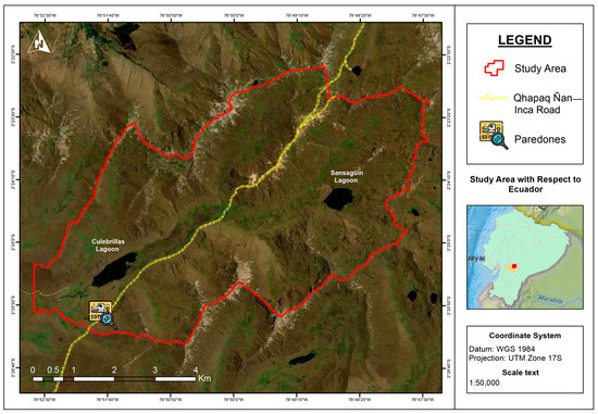
Figure 1.
Location map of the study area. The red polygon represents the hydrographic unit that provides water to the lake system, while the yellow line is the Qhapaq Ñan.
Cultural and ethnographic elements are combined with the valuable natural heritage of this location, generating a territory with a very high geotourism value. Geotourism is considered an activity that allows the visitor to relate to the geology, landscapes, and geoforms present in a territory, but it also allows one to delve into the relationship between the people and their culture and their environment [11,12,13]. These conditions render geotourism a very versatile activity, capable of adapting to any type of geographical condition, and, therefore, it is easy to apply and disseminate its principles in other territories with similar conditions. In addition, geotourism creates opportunities for economic development from a sustainable application, while generating spaces to disseminate scientific, geological, and geomorphological knowledge of a given location [14,15].
With this antecedent, the present work explores the intrinsic value of the multiple components present in the study area (physical, biological, social, and others) adopting a systemic approach and applying techniques of geomorphological interpretation, telematics, literature review, and the ethnography of the sector. Once the main attributes or interests of the identified elements were defined and characterized, degrees of vulnerability and affectation were established, as well as potential use and possible tourist applications, individually and jointly.
The development of geotourism interpretation routes is proposed through interpretive circuits, using some sites of geological, geomorphological, biological, and cultural interest. In the same way, it is expected that the information generated can be used as input for general knowledge of local communities, thus promoting the nature tourism and cultural tourism that are currently being conducted in this natural area.
2. Materials and Methods
Due to the applied and descriptive nature of this research, a systematic process of gathering information in situ was established which was evaluated and complemented with information from secondary sources (documentary and correlational research), to create relevant information that produces a guide towards the possible uses of the identified elements. In general, the methodology used corresponds to an inventory process, which later receives a standard assessment that uses qualitative–quantitative indicators collected in the study area; subsequently, all this information is complemented with cartographic data. According to Quesada-Valverde and Quesada-Román [16], this set of methods is a standard procedure for the valuation and promotion of geotourism and has a wide range of applications [17,18]. However, beyond the applicable methodological processes, the dissemination and sustainable promotion of the listed sites must always prevail [19].
2.1. Delimitation of the Study Area
Although the Culebrillas Lagoon is a perfectly delimited lacustrine body, its hydrographic dynamics are related to a series of micro-basins that contribute water and sediments within its system [20]. For this reason, the work area was delimited based on the hydrographic criteria that comprise the limit of the hydrographic unit of the Culebrillas Lagoon System. The spatial configurations of each micro-basin that comprise this system were socialized with the park ranger staff of the Sangay National Park and local tourist guides in order to obtain the local denomination of each sector, so as to label each micro-basin.
2.2. Qualitative Characterization of the Elements of Interest Present in the Study Area
2.2.1. Geological and Geomorphological Analysis
A geomorphological survey or geomorphological mapping of a selective nature was applied based on direct observation criteria, considering that the judgments issued were related to specific reasoning towards the observed relief elements in addition to the analysis of geological elements that condition or favor the presence of certain features of the landscape [21,22,23]. Information was collected using the cross-sectional geological mapping method, also called profile mapping [24], considering the permanent exposure of rocks.
For the application of the geological trail method, a route or routes had been previously established, following the outline of the Qhapaq Ñan. At the turnoff to Cueva de Espíndola, the Inca Trail deviates to the northeast, to advance to the Sansagüin Lagoon (towards the east); it is necessary to advance cross-country along the swamp, with little exposure of materials. For places with difficult access, and as a complement, a geomorphological map was generated with digital elevation models, using as a resource the ALOS PALSAR L1.5 of 12.5 m spatial resolution [25], and a Sentinel 2A satellite image of 5 July 2021, to, finally, apply remote-sensing techniques and reading and interpretation of topographic maps and aerial photos.
2.2.2. Characterization and Identification of Sites of Biological, Cultural, and Ethnographic Interest
During field visits, approaches were generated with local tourist guides of Cañari nationality and park rangers of the Sangay National Park. Based on participant observation [26], additional information was obtained on cultural and ethnographic aspects of the sector, complemented with bibliographic sources. In the same way, information on possible biological interests in the sector was gained through a bibliographic search and electronic means of the Ministry of the Environment, Water, and Ecological Transition.
2.2.3. Qualitative Evaluation of the Identified Sites
Once geological, geomorphological, cultural, ethnographic, and biological elements were defined, their potential was assessed according to the following attributes: main interests (if a site has multiple conditions that render it a site of interest), superlative value (if it is a unique example at the national level), potential uses (different activities are established in which this element can be applied), state of conservation (condition or current state of the resource), and degree of vulnerability (susceptibility to damage, harm, or threat). Each of these parameters was assessed from a qualitative scale, using a Likert weighting scale with five weighting points [27]. Each element of interest received an assessment according to the scale in each of five attributes (Table 1). Finally, total sums were generated and a standardization of the values obtained in the sums, establishing elements with highest weights through distribution ranges to generate qualitative assessments: ≥5 and <11.66 (low); ≥11.66 and <18.32 (medium); ≥18.32 and ≤25 (high).

Table 1.
Evaluation parameters with their corresponding descriptions and weighting values.
2.2.4. Strategies for Using Identified Sites
After sites of geotourism interest have been identified and evaluated, the creation of a network of geocultural interpretive trails is finally established within the hydrographic unit of the Culebrillas Lagoon System, for which existing trails that connect the sites of interest were georeferenced and mapped, creating several interpretive routes with different interests. In addition, a list of activities that can be conducted at each site of interest was established.
3. Results
Culebrillas Lagoon (local inhabitants of the Cañari nationality also call it the “Leoquina” Lagoon) is a lacunar body whose water mirror covers an area of 0.41 km2, with a longitudinal extension of 1350 m, a width of 445 m, and a maximum depth of 19.2 m in its central area. It is located at 3875 m above sea level in a depression at the foot of Yanahurco Hill [28], and others summits with average 4350 m above sea level, with strong features and structures of glacial origin. It receives the contribution of water and sediments through eight tributary hydrographic units and six minor drainage units, in an area of 38.98 km2 (Figure 2), which together form the hydrographic unit of the Culebrillas Lagoon System.
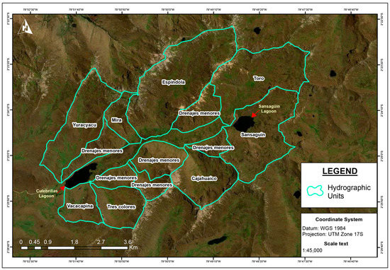
Figure 2.
Location map of tributary hydrographic units and minor drainage units that are part of the hydrographic unit of the Culebrillas Lagoon System.
It is known that the climatic variations that occurred at the end of the Pleistocene era have left traces in the Andean rock massifs, generating the construction of glacial valleys due to the retreat of glacial tongues, sediment deposits of glacial origin, and other morphologies of glacial deposition and erosion [29,30], complemented by other tectonic processes which compete with erosive effects [31]. The relief and current landscapes are generated in response to temporal and spatial changes, which give evidence of the past of a territory [22,32]. In this context, it is defined that the hydrographic unit of the Culebrillas Lagoon System corresponds to a fluvial system, whose origin is linked to the melting of pre-existing glaciers. Culebrillas Lagoon is the distal part of a glacial tongue, whose damming was generated thanks to sediment deposits forming a terminal moraine, occurring when the glacial tongue melted and silted up, until it adopted its current morphology. Currently, the Sansagüin river valley emerges as the main receptor and transporter of sediments within the fluvial system, a torrent whose slope oscillates at 3.7% (Figure 3).
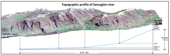
Figure 3.
Topographic profile of the Sansagüin river. In this image, we can see the source of the channel from the moraine of the Sansagüin Lagoon, at 4011 m of altitude, and its mouth in the Laguna de Culebrillas, at 3875 m of altitude.
From a geological, structural, climatic, cultural, and environmental perspective, these historical conditions mark a path to understanding the great variability of geoforms and reliefs that frame this study area [33]. Figure 4 details the consistent elements of a typical high mountain glacier morphology, whose determining and characteristic feature of the historical glacial activity of the study area is highlighted by the large “U”-shaped valley in which Culebrillas Lagoon is located, with the Sansagüin brook, with its terminal moraine, to the east. In the same way, hanging valleys are observed with unevenness generated between the main and secondary glacial valleys. In the upper part of the hydrological unit, elongated (drumlin-type) and rounded (kame-type) glacial sediment mounds are observed. In greater detail, it is possible to highlight the glacial striations or striated rocks which reveal scratch marks on the rocks, generated by the sliding of ice on the rocky substrate.
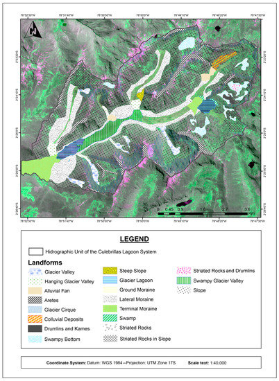
Figure 4.
Geomorphological map of the hydrographic unit of the Culebrillas Lagoon System.
The geomorphological diversity of the study area is the perfect framework for the identification of morphologies and geoforms of glacial origin, typical in the Andean reliefs, which emerge in the valleys as a consequence of global climate change, which affects the Andean glaciers [34,35,36,37,38]. The geological and geomorphological elements, present in this hydrographic unit, were complemented by an adequate climatic framework, allowing the development and settlement of different local groups (mainly Cañaris and Incas), whose manifestations and cultural evidence are distributed along different pedestrian routes, adjacent to the Qhapaq Ñan. In the study area, there are perfectly defined constructions and archaeological and historical elements, created from a historical appropriation of their environment, among which the Qhapaq Ñan emerges as one of the main local pre-Hispanic structures [39,40].
A total of 27 sites of interest were inventoried: 19 of geological–geomorphological interest, seven of cultural–ethnographic interest, and one of biological interest (Figure 5), considering their accessibility and availability for visiting. Each of the inventoried elements has a property that differentiates or characterizes them for the interpretation and/or description of an event and/or cultural or natural phenomenon (Figure 6). The 27 sites were evaluated according to the following attributes: main interests, superlative value, potential uses, state of conservation, and degree of vulnerability (Table 2).
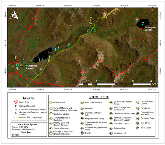
Figure 5.
Location map of geological–geomorphological, cultural–ethnographic, and biological sites of interest in the hydrographic unit of the Culebrillas Lagoon System.
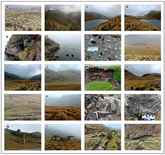
Figure 6.
Geological–geomorphological, cultural–ethnographic, and biological sites of interest in the hydrographic unit of the Culebrillas Lagoon System. (a) Glaciar erratic blocks; (b) Terminal Moraine and Glacier Valley of Culebrillas; (c) Culebrillas Lagoon and Glacier Valley; (d) Terminal Moraine of Culebrillas; (e) Machay Cave and Glaciers Terraces; (f) Glaciers Terraces; (g) Outcrops of Tillite rocks (Glacial Sediments); (h) Abandoned Meander; (i) Swamps and Glacier Valley; (j) Hanging Glacier Valley; (k) Fluvio–Glacial Sediment Deposits; (l) Espindola Hanging Glacier Valley; (m) Drumlin; (n) Drumlins and Kames Fields; (o) Rock outcrops with Gelifraction; (p) Outcrop of Striated rocks; (q) Yanahurco Hill; (r) Paredones; (s) Qhapaq Ñan—Inca Road; and (t) Espindola Cave.
Table 2.
Evaluation of geotouristic potential of geological–geomorphological, cultural–ethnographic, and biological sites of interest in the hydrographic unit of the Culebrillas Lagoon System.
The data set in Table 2 determines that 70.37% of the evaluated sites have high geotourism potential, complemented by 29.63% of sites with medium potential, which establishes that all the inventoried elements have a level of interest as potential sites for the use of geotourism activities. As additional data, 81.48% of the sites denote some level of geological–geomorphological interest, being the main interest of the study area, which is related to the landscape and natural potential of the study area, within the Sangay National Park.
4. Discussion
The evaluations presented in this work based on field information inevitably define the intrinsic geotourism potential of the hydrographic unit of the Culebrillas Lagoon System. The geomorphological features generated as a consequence of glacial processes indicated in this research are valuable resources to develop activities that link science and leisure [41]. Coronato et al. [42,43] give the example of the glacial morphologies present in Tierras de Fuego, Argentina, and potential current use for geotourism. Similarly, Duraj et al. [44] point out various geomorphological interests of glacial origin existing in the Ostrava region (the Czech Republic) and their potential for use in geotourism activities.
In general, the Andes mountains have a regional geological relevance that can serve as an integrating element of geobiodiversity; their complex geological origin, the variety of adjacent environments and ecosystems, as well as the interactions with millennial ancestral cultures, are fundamental conditions to consider the singularities of this Andean geoheritage [45]. Tavera Escobar et al. [46] establish that the geomorphosites of volcanic–glacial origin present in the Nevado del Ruiz (Colombia) display characteristics of superlative value, capable of attracting hundreds of visitors annually. In another sector, in the south of Ecuador, Navarrete et al. [47] conducted an inventory of geosites in the Cajas National Park, concluding that the glacial and periglacial landscapes and landforms, the products of historical deglaciation processes during the Pleistocene era present in this area, maintain a valuable potential for the development of educational activities and geo tourism.
The inventoried elements comply with the goals of nature and adventure tourism, complemented by geological and geomorphological knowledge. In this sense, geotourism appears to be a viable alternative for the use of geological and geographic resources as a means of using and generating enjoyment from geosystems in a sustainable manner [48]. The geotourism approach involves the conservation of geological elements while also raising awareness of terrestrial dynamics through outdoor activities, museums, and visitor centers, these activities being aimed at audiences of different ages [13]. Geotourism as well as nature tourism are excellent prospects not only for knowledge about the environment but also because of being outdoor activities, which benefit post-pandemic physical and mental health [49].
Added to the geomorphological and geological value, cultural value is an intrinsic enhancer of the study area, which is combined with natural elements. In one of his most emblematic literary works, the Ecuadorian historian Juan de Velasco [9] affirms that the lagoon and the Culebrillas river seem to be works made by hand for indigenous peoples. In the same way, Ortega Heras and Atancuri Pacurucu [10] point out that Culebrillas is in an impressive stony space, whose elevations are abrupt and give the sensation of having been cut by humans. The worldview and orality of the Cañari ancestral groups (i.e., their cultural expressions), along with literary disputes, have caused local communities to question the natural origin of the Culebrillas Lagoon, which has been positive, considering that the sacredness and religiosity granted to the lagoon has served as a preponderant factor for its conservation [10,50,51].
Pre-Hispanic cultural elements in the study area have generated patterns of settlements in housing and communication constructions which have been perfectly defined and created from a historical appropriation of their environment, and generated with clear objectives [39,40]. The Qhapaq Ñan is one of the main existing pre-Hispanic structures in this territory, from which emerge complex networks of roads used by residents and local communities [7] (Figure 7).
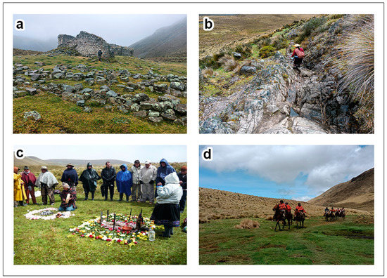
Figure 7.
Some archaeological and cultural interests present in the study area. (a) Panoramic view of Tambo Paredones, Inca construction, intended for the rest of the messengers (Chasqui) who traveled for the Qhapaq Ñan; (b) one of the sections of the Qhapaq Ñan, comprised of bedrock. Very well preserved sections of Inca Road can be seen in this sector; (c) religious activities for the celebration of Inti Raymi (festival of the sun); and (d) deployment of Andean cowboys (chagra), who belong to the Cañari ethnic group.
Pre-existing trails that circulate around and in neighboring sites of the Culebrillas Lagoon comprise a complete network of roads, whose extension is around 16 km and connect 92.6% of the sites of interest evaluated in this work (Figure 8). Integrating the trail networks with the recreational activities that are currently conducted in the area (camping, hiking, cultural and natural interpretation, and fishing, among others) (Figure 9) would increase the options available to the 3000 visitors who, on average, attend this conservation area annually, according to the visitor records of the Sangay National Park.
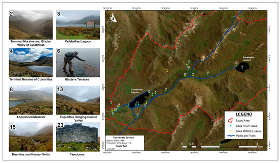
Figure 8.
The network of trails that cover the study area, adjacent to the Culebrillas Lagoon. 92.6% of the inventoried sites of interest have direct access through this network of trails.
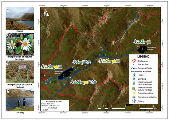
Figure 9.
Explanatory map with some of the tourist activities conducted within the area of influence of the Culebrillas Lagoon: (1) hiking around the Culebrillas Lagoon; (3) visualization of characteristic flora of the Andean Paramos; (4) interpretive trails of cultural heritage; and (7) trout fishing in the Culebrillas Lagoon.
5. Conclusions
The evaluations obtained confirm the potential of the study area; however, the evaluations have not considered other important aspects, for example, the context of the study area, due to Culebrillas Lagoon being part of a cultural circuit that involves sites of archaeological tradition, such as Ingapirca, El Tambo, Coyoctor, and the municipality of Cañar (known as the archaeological capital of Ecuador) [28,52]. Other variables to consider are the lack of, or limited, tourist infrastructure surrounding the lagoon, lack of signage, and difficult access routes (rural roads require maintenance)—you must travel many kilometers from El Tambo to Culebrillas, along a rural road. Undoubtedly, this factor diminishes the intrinsic potential of the study area.
On the other hand, facilities of the Sangay National Park visitor center in the Culebrillas Lagoon look quite appropriate for receiving visitors, according to the average annual number of tourists it attracts. The visitor center fulfills the roles of registration and lodging for the park ranger team due to the main activities conducted in the area being linked to outdoor activities.
It is important to exploit the main existing fortresses around Culebrillas, which are related to the cultural identity of the Cañari people and their ancestral significance, adding a conservation value driven from the sacredness that local communities grant to this environment. The presence of the Qhapaq Ñan as a World Heritage Site [7], and the networks of ancestral trails that have been previously identified and used by park rangers and local tour guides, provide a superlative value, worthy of highlighting and taking advantage of. The routes lack standardization, evidence of planning, and systematization. Visitors or guides possibly use paths interchangeably, without a pre-established order and without pertinent information, according to whatever activities they are pursuing at any given moment.
Undoubtedly, this preliminary analysis provides input that will lead to the strengthening of the management’s strategies for tours and visits. There are multiple possibilities for research on geoheritage, its possible uses, and improvements in its management, and the managers would be encouraged to apply a sustainable vision which considers the cultural links and conservation of the previously described elements.
Author Contributions
Conceptualization: J.L.S.-C.; methodology: J.L.S.-C., V.M.-E., K.V.-M. and C.N.-F.; software: V.M.-E. and K.V.-M.; investigation: J.L.S.-C., V.M.-E., K.V.-M. and C.N.-F.; writing—review and editing: J.L.S.-C. and K.V.-M. All authors have read and agreed to the published version of the manuscript.
Funding
This research was carried out thanks to the contribution of the National Institute of Cultural Heritage of Ecuador, through the Call for Promotion Line for Research on Cultural Heritage and Social Memory 2022–2023, project INPC-LF-INV-2022-007.
Conflicts of Interest
The authors declare no conflict of interest.
References
- Ramos, A. El desarrollo de la etnohistoria andina a través de la (re)definición de lo andino (1970–2005). Front. Hist. 2018, 23, 8–43. [Google Scholar] [CrossRef]
- Vivanco Pomacanchari, C. Obras hidráulicas de etapa prehispánica en Huaccana, Chincheros—Apurimac. Arqueol. Soc. 2015, 30, 315–333. [Google Scholar] [CrossRef]
- Reindel, M.; Isla, J. Cambio climático y patrones de asentamiento en la vertiente occidental de los Andes del sur del Perú. Diálogo Andin. 2013, 41, 83–99. [Google Scholar] [CrossRef]
- Levillier, R. Los Incas; Escuela de Estudios hispanoamericanos de Sevilla: Sevilla, Spain, 1956. [Google Scholar]
- Bar Esquivel, A. Afectaciones históricas a la red vial inca y la necesidad del estudio documentario de carreteras para la investigación y el registro de caminos prehispánicos. In Cuadernos del Qhapaq Ñan; Marcone Flores, G., Barraza Lescano, S., Eds.; Ministerio de Cultural del Perú: Proyecto Qhapaq Ñan, Peru, 2013; Volume 1, pp. 32–51. [Google Scholar]
- Hyslop, J. Qhapaq Ñan. In El Sistema Vial Incaico; Instituto de Estudios Arqueológicos (INDEA)-Petróleos del Perú: Lima, Peru, 1992. [Google Scholar]
- UNESCO. Qhapaq Ñan Sistema Vial Andino. In Nuevos Esfuerzos en Favor de su Conservación Sostenible; Organización de las Naciones Unidas para la Educación, la Ciencia y la Cultura: London, UK, 2021. [Google Scholar]
- ECOLAP; MAE. Guía del Patrimonio de Áreas Naturales Protegidas del Ecuador; ECOFUND, FAN, DarwinNet, IGM: Quito, Ecuador, 2007; pp. 165–175. [Google Scholar]
- de Velasco, J. Historia del Reino de Quito en la América Meridional (2 Tomos); Casa de la Cultura Ecuatoriana: Quito, Ecuador, 1789. [Google Scholar]
- Ortega Heras, M.J.; Atancuri Pacurucu, N.P. Los Nuevos descubrimientos de los Asentamientos Cañaris. Bachelor’s Thesis, Universidad Politécnica Salesiana, Cuenca, Ecuador, 2011. [Google Scholar]
- Newsome, D.; Dowling, R.K. Geotourism: The Tourism of Geology and Landscape; Goodfellow Publishers: Oxford, UK; London, UK, 2010. [Google Scholar] [CrossRef]
- Dowling, R.K. Global Geotourism—An Emerging Form of Sustainable Tourism. Czech J. Tour. 2012, 2, 59–79. [Google Scholar] [CrossRef]
- Newsome, D.; Dowling, R.K.; Leung, Y. The nature and management of geotourism: A case study of two establish iconic geotourism destinations. Tour. Manag. Perspect. 2012, 2–3, 19–27. [Google Scholar] [CrossRef]
- Hose, T.A. European “Geotourism”—Geological interpretation and geoconservation promotion for tourist. In Geological Heritage: Its Conservation and Management; Barretino, D., Wimbledon, W.P., Gallego, E., Eds.; Instituto Tecnológico Geominero de España: Madrid, Spain, 2000; pp. 127–146. [Google Scholar]
- Štrba, Ľ.; Kolačkovská, J.; Kudelas, D.; Kršák, B.; Sidor, C. Geoheritage and Geotourism Contribution to Tourism Development in Protected Areas of Slovakia—Theoretical Considerations. Sustainability 2020, 12, 2979. [Google Scholar] [CrossRef]
- Quesada-Valverde, M.E.; Quesada-Román, A. Worldwide Trends in Methods and Resources Promoting Geoconservation, Geotourism, and Geoheritage. Geosciences 2023, 13, 39. [Google Scholar] [CrossRef]
- White, S.; Wakelin King, G.A. Earth sciences comparative matrix: A comparative method for geoheritage assessment. Geogr. Res. 2014, 52, 168–181. [Google Scholar] [CrossRef]
- Štrba, L.U.; Rybár, P.; Baláž, B.; Molokáč, M.; Hvizdák, L.; Kršák, B.; Lukáč, M.; Muchová, L.; Tometzová, D.; Ferenčíková, J. Geosite assessments: Comparison of methods and results. Curr. Issues Tour. 2015, 18, 496–510. [Google Scholar] [CrossRef]
- Filocamo, F.; Rosskopf, C.M.; Amato, V. A contribution to the understanding of the Apennine landscapes: The potential role of Molise geosites. Geoheritage 2019, 11, 1667–1688. [Google Scholar] [CrossRef]
- Zolitschka, B.; Francus, P.; Ojala, A.E.K.; Schimmelmann, A. Varves in lake sediments—A review. Quat. Sci. Rev. 2015, 117, 1–41. [Google Scholar] [CrossRef]
- Lahee, F.H. (Ed.) Geología Práctica; Omega: Barcelona, Spain, 1985. [Google Scholar]
- Lugo Hubp, J. Elementos de Geomorfología Aplicada (Métodos Cartográficos); Instituto de Geografía, Universidad Nacional Autónoma de México: Mexico City, Mexico, 1988. [Google Scholar]
- Rodríguez Infante, A. Geomorfología. Available online: https://ninive.ismm.edu.cu/bitstream/handle/123456789/1661/RodriguezG.pdf?sequence=1&isAllowed=y#:~:text=La%20geomorfolog%C3%ADa%20como%20toda%20ciencia,naturalmente%20debe%20evitar%20las%20ilusiones (accessed on 1 March 2023).
- Coe, A.L.; Argles, T.W.; Rothery, D.A.; Spicer, R.A. Geological Field Techniques; John Wiley & Sons, Ltd.: London, UK, 2010. [Google Scholar]
- JAXA/METI. ALOS PALSAR L1.5 2011. Available online: https://asf.alaska.edu/ (accessed on 1 December 2022).
- Spradley, J. Participant Observation; Waveland Press, Inc.: Long Brove, IL, USA, 1980. [Google Scholar]
- Chhabra, D.; Healy, R.; Sills, E. Staged authenticity and heritage tourism. Ann. Tour. Res. 2003, 30, 702–719. [Google Scholar] [CrossRef]
- Cárdenas Ordóñez, G.S.; Quinteros Vicuña, G.E. Cañar Capital Arqueológica y Cultural del Ecuador: Análisis de su Declaración y Proyecciones. Bachelor’s Thesis, Universidad de Cuenca, Cuenca, Ecuador, 2011. [Google Scholar]
- Silva, P.G.; Bardají, T.; Roquero, E.; Baena-Preysler, J.; Cearreta, A.; Rodríguez-Pascua, M.A.; Rosas, A.; Zazo, C.; Goy, J.L. El Periodo Cuaternario: La Historia Geológica de la Prehistoria. Cuatern. Geomorfol. 2017, 31, 113–154. [Google Scholar] [CrossRef]
- Street-Perrott, F.A.; Roberts, N.; Metcalfe, S. Geomorphic implications of late Quaternary hydrological and climatic changes in the Northern Hemisphere tropics. In Environmental Change and Tropical Geomorphology; Douglas, I., Spencer, T., Eds.; Allen and Unwin: London, UK, 1985; pp. 164–183. [Google Scholar]
- Davis, W.M. The geographical cycle. Geogr. J. 1899, 14, 481–504. [Google Scholar] [CrossRef]
- Böse, M. From Morphostratigraphy to Chronostratigraphy—Modern Quaternary Geomorphology as a Basic for Climatic Research. Géomorphologie Relief Process. Environ. 2014, 20, 303–306. [Google Scholar] [CrossRef]
- Bennett, M.R.; Glasser, N.F. Glacial Geology: Ice Sheets and Landforms, 2nd ed.; Wiley-Blackwell: Oxford, UK, 2009; p. 385. [Google Scholar]
- Heine, K. Tropical South America during the Last Glacial Maximum: Evidence from glacial, periglacial and fluvial records. Quat. Int. 2000, 72, 7–21. [Google Scholar] [CrossRef]
- Rabatel, A.; Francou, B.; Soruco, A.; Gomez, J.; Cáceres, B.; Ceballos, J.L.; Basantes, R.; Vuille, M.; Sicart, J.E.; Huggel, C.; et al. Current state of glaciers in the tropical Andes: A multi-century perspective on glacier evolution and climate change. Cryosphere 2012, 7, 81–102. [Google Scholar] [CrossRef]
- Francou, B.; Rabatel, A.; Soruco, A.; Sicart, J.E.; Silvestre, E.E.; Ginot, P.; Cáceres, B.; Condom, T.; Villacís, M.; Ceballos, J.L.; et al. Glaciares de los Andes Tropicales Víctimas del Cambio Climático; CAN–PRAA–IRD: Quito, Ecuador, 2012; p. 99. [Google Scholar]
- Zemp, M.; Frey, H.; Gärtner-Roer, I.; Nussbaumer, S.U.; Hoelzle, M.; Paul, F.; Haeberli, W.; Denzinger, F.; Ahlstrøm, A.P.; Anderson, B.; et al. Historically unprecedented global glacier decline in the early 21st century. J. Glaciol. 2015, 61, 745–762. [Google Scholar] [CrossRef]
- Vuille, M.; Franquist, E.; Garreaud, R.; Casimiro, W.S.L.; Cáceres, B. Impact of the global warming hiatus on Andean temperature. J. Geophys. Res. Atmos. 2015, 120, 3745–3757. [Google Scholar] [CrossRef]
- Chang, K. A typology of settlement and community patterns in some circumpolar societies. In Arctic Anthropology; Madison University of Wisconsin Press: Madison, WI, USA, 1962; Volume 1, pp. 28–41. [Google Scholar]
- Prieto Rodríguez, M. Los patrones de asentamiento: Una herramienta metodológica para la reconstrucción del pasado. Boletín Antropológico 2011, 29, 116–131. [Google Scholar]
- Schwarz, S.; Migoń, P. When science and leisure meet: A geotourist itinerary in Southern Tierra del Fuego, Argentina. In Advances in Geomorphology and Quaternary Studies in Argentina; Rabassa, J., Ed.; Earth System Sciences; Springer: Berlin/Heidelberg, Germany, 2017; pp. 49–75. [Google Scholar] [CrossRef]
- Coronato, A.; Schwarz, S.; Flores Barrera, F. Glacial landforms as geodiversity resources for geotourism in Tierra del Fuego, Argentina. Quaest. Geogr. 2022, 41, 5–24. [Google Scholar] [CrossRef]
- Coronato, A.; Meglioli, A.; Rabassa, J. Glaciations in the Magellan Straits and Tierra del Fuego, Southernmost South America. In Quaternary Glaciations—Extent and Chronology. Part III; Ehlers, J., Gibbard, P., Eds.; Quaternary Book Series; Elsevier: Amsterdam, The Netherlands, 2004; pp. 45–48. [Google Scholar] [CrossRef]
- Duraj, M.; Niemiec, D.; Cheng, X.; Koleňák, P. Vestiges of Glacial Action in Ostrava: Their Significance for and Application in Geotourism. In Proceedings of the IOP Conference Series: Earth and Environmental Science, Zvenigorod, Russia, 4–7 September 2017; pp. 1–6. [Google Scholar] [CrossRef]
- Pessoa, G.E.; Steinke, V.A. The Relevance of the South American Nevados for Geoheritage. Geoheritage 2023, 15, 61. [Google Scholar] [CrossRef]
- Tavera Escobar, M.A.; Estrada Sierra, M.; Errázuriz Henao, C.; Hermelin, M. Georutas o itinerarios geológicos: Un modelo de geoturismo en el Complejo Volcánico Glaciar Ruiz-Tolima, Cordillera Central de Colombia. Cuad. Geogr. Rev. Colomb. Geogr. 2017, 26, 219–240. [Google Scholar] [CrossRef]
- Navarrete, E.; Morante-Carballo, F.; Dueñas-Tovar, J.; Carrión-Mero, P.; Jaya-Montalvo, M.; Berrezueta, E. Assessment of Geosites within a Natural Protected Area: A Case Study of Cajas National Park. Sustainability 2022, 14, 3120. [Google Scholar] [CrossRef]
- Gray, M. Other nature: Geodiversity and geosystem services. Environ. Conserv. 2011, 38, 271–274. [Google Scholar] [CrossRef]
- Buckley, R.C.; Cooper, M.A. Tourism as a Tool in Nature-Based Mental Health: Progress and Prospects Post-Pandemic. Int. J. Environ. Res. Public Health 2022, 19, 13112. [Google Scholar] [CrossRef] [PubMed]
- Carrillo, A. Informe de los Trabajos de Prospección, Limpieza y Relevamiento, Realizados en el Sitio Arqueológico “Culebrillas”, 1993–1997; Instituto Nacional de Patrimonio Cultural, Departamento de Arqueología: Cuenca, Ecuador, 1998. [Google Scholar]
- Idrovo Urigüen, J. Fluctuaciones del Nivel del Agua en la LAGUNA de Culebrillas, Provincia del Cañar, Prospección Arqueológica y Propuesta Para su Embalse; CEDIR-PROMAS: Cuenca, Ecuador, 2008. [Google Scholar]
- Alfaro Reyes, E.; Chalá Cruz, J.; Delgado Espinoza, F.; Eguiguren Eguiguren, A.; Guerrero Arias, P.; Herrera Montero, L.; María Larrea, A.; Rivadeneira Silva, M.; Sánchez-Parga, J.; Viteri, M.A. La Arqueología y la Antropología en Ecuador; Editorial Universitaria Abya-Yala: Quito, Ecuador, 2011. [Google Scholar]


Disclaimer/Publisher’s Note: The statements, opinions and data contained in all publications are solely those of the individual author(s) and contributor(s) and not of MDPI and/or the editor(s). MDPI and/or the editor(s) disclaim responsibility for any injury to people or property resulting from any ideas, methods, instructions or products referred to in the content. |
© 2023 by the authors. Licensee MDPI, Basel, Switzerland. This article is an open access article distributed under the terms and conditions of the Creative Commons Attribution (CC BY) license (https://creativecommons.org/licenses/by/4.0/).