Proceeding Paper

Utilizing AEOLUS to Improve Dust Transport Modelling †

1
Institute for Astronomy, Astrophysics, Space Applications and Remote Sensing, National Observatory of Athens (NOA), 15236 Athens, Greece
2
Department of Applied and Environmental Physics, Aristotle University of Thessaloniki (AUTH), 54124 Thessaloniki, Greece
3
Royal Netherlands Meteorological Institute (KNMI), 3731 GA De Bilt, The Netherlands
4
Research Centre for Atmospheric Physics and Climatology, Academy of Athens (AoA), 10679 Athens, Greece
5
Leibniz Institute for Tropospheric Research (TROPOS), 04318 Leipzig, Germany
6
Department of Geography, Harokopion University of Athens (HUA), 17676 Athens, Greece
7
Department of Meteorology and Climatology, Aristotle University of Thessaloniki (AUTH), 54124 Thessaloniki, Greece
8
European Centre for Medium-Range Weather Forecasts (ECMWF), Shinfield Park, Reading RG2 9AX, UK
9
European Space Agency, 00044 Frascati, Italy
*
Author to whom correspondence should be addressed.
Presented at the 16th International Conference on Meteorology, Climatology and Atmospheric Physics—COMECAP 2023, Athens, Greece, 25–29 September 2023.
Environ. Sci. Proc. 2023, 26(1), 193; https://doi.org/10.3390/environsciproc2023026193
Published: 15 September 2023

Abstract

:
The European Space Agency’s AEOLUS mission provides vertical profiles of the horizontal line-of-sight (HLOS) wind component in the troposphere and lower stratosphere, as well as secondary products with retrievals of extinction and backscatter coefficients. Under the scope of the ESA L2A+ project, we present an assimilation system of both wind and aerosol information from AEOLUS in a regional numerical weather prediction model (WRF). This study aims to highlight the impact of such a dataset on desert dust transport through assimilation experiments over the broader North Atlantic Ocean region, which features high dust transport events through the Saharan Air Layer. The results will be validated through comparisons with observations from the ESA-ASKOS/JATAC experiments.

1. Introduction

While it has been demonstrated that the spatiotemporal distribution of atmospheric aerosols can be improved through the assimilation of vertical aerosol profiles from lidar instruments [1] (such as the Cloud–Aerosol Lidar with Orthogonal Polarization satellite—CALIOP [2]—or the ground-based European Aerosol Research Lidar Network—EARLINET [3]) through multiple studies, most operational aerosol forecasting systems use only column-integrated observations of the aerosol optical depth (AOD) from satellites [4,5,6]. Therefore, the vertical structure of the aerosol layers is only determined using the numerical model and only the magnitude of the dust load is adjusted through observations.
The AEOLUS mission by the European Space Agency (ESA) is uniquely positioned to aid in aerosol modelling through its unique products. While primarily providing vertical profiles of horizontal line-of-sight wind speeds (HLOS), the satellite also provides secondary products of extinction and backscatter profiles. Joint assimilation of both products, wind and aerosol, impacts aerosol representation in two ways. Firstly, wind information affects dust emission, transport, and deposition, while the extinction and backscatter profiles provide direct information about the vertical distributions of aerosols in the atmosphere.
The aim of this study is to demonstrate the impact of AEOLUS on regional NWP, focusing on dust transport patterns over the general North Atlantic region. Our assimilation system consists of the Weather Research and Forecasting model with chemistry enabled (WRF-CHEM) and the Data Assimilation Research Testbed (DART), which implements Ensemble Kalman Filters. To account for some deficiencies of the aerosol product of AEOLUS, we will utilize the L2A+ dataset that is developed under the scope of the ESA L2A+ project. The results of the assimilation experiments will be validated through comparison with independent (i.e., not assimilated) ground-based and airborne measurements from the ESA ASKOS-JATAC tropical campaign that took place on Cabo Verde during the summers of 2021 and 2022.

2. Methods and Materials

In this section, we describe the various methods, tools, and datasets we utilize in the assimilation studies to assess the impact of AEOLUS assimilation in dust transport modelling.

2.1. AEOLUS

AEOLUS, the European Space Agency’s satellite mission, launched in August of 2018 carrying the Atmospheric Laser Doppler Instrument (ALADIN) with the purpose of providing wind speed profiles on a global scale. ALADIN emits laser pulses at 354.8 nm and receives molecular and particulate backscatter in one channel (Mie channel), and backscatter from hydrometeors in another (Rayleigh channel). The primary scientific goal of the mission was to improve numerical weather prediction and it has been shown that assimilation of the horizontal line-of-sight wind profiles (HLOS) has a disproportionately large impact compared to their volume [7]. The improved wind information directly impacts aerosol transport, and it has been demonstrated that this can help the numerical models accurately capture extreme events, such as volcanic plume transport.
While the aerosol product of AEOLUS (L2A) is of reasonable quality [8], the lack of a cross-polar channel means that the instrument underestimates the backscatter of highly polarizing targets, such as desert dust. This limitation also hampers the ability to distinguish between aerosols and clouds. Under the scope of the ESA L2A+ project, an improved aerosol product from AEOLUS is developed to address these concerns through data fusion techniques. To create the new product, rigorous cloud-screening is performed to remove contaminated bins and then dust layers are identified through comparisons with other datasets (such as the CAMS reanalysis). Finally, a weighting factor is applied to the dust layers to account for the measurement deficiency.
In this study, we use both the original L2A and the improved L2A+ products to highlight the improvements for further processing, but also to emphasize the importance of a cross-polar measurement channel in future missions. The exact experimental setup is described in a subsection further down.

2.2. WRF-CHEM

The regional model we are using is the Weather Research and Forecasting model, coupled with the GOCART/AFWA aerosol and dust emission module [9]. Our numerical simulations take into account the radiative impact of aerosols to study the impact of the improved aerosol fields on the atmosphere. We aim for a horizontal resolution of 20 × 20 km (subject to availability of computational resources) and 38 vertical levels. As initial conditions, we use IFS outputs for the period of interest that have been produced without any AEOLUS assimilation, courtesy of ECMWF.

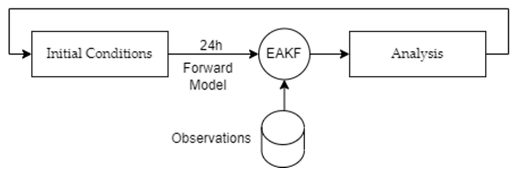
2.3. Data Assimilation Research Testbed

The Ensemble Kalman Filter we use to perform our assimilation experiments is implemented in the Data Assimilation Research Testbed (DART). DART is an open-source, model-agnostic assimilation toolkit by NCAR that implements a collection of ensemble assimilation algorithms [10]. The Ensemble Adjustment Kalman Filter (EAKF) is the one most commonly used and has been extensively studied. In this setup, an ensemble of 24 members is used to estimate the background (i.e., model) error before observations are used to correct the model state. Our assimilation experiment size consists of 1 month, plus 7 days for model spin-up. Observations are assimilated every 24 h (00:00 UTC), meaning the analysis increments are calculated using observations from 24 h before the assimilation step.

Ensemble Adjustment Kalman Filter

The Ensemble Adjustment Kalman filter (EAKF) has been extensively used in data research for its ability to retain higher-order moments in the prior (i.e., background error) distributions. The filtering computation is performed in two steps, with the first computing the observational increment produced by the k th observation for the i th ensemble member as
Δ y i , k O = y k ¯ 1 + κ 2 ( y k ,   y k O ) + y k O 1 + κ 2 ( y k , y k O ) + y i , k y k ¯ 1 + κ 2 y k , y k O y i , k
where the first two terms represent the change in the ensemble mean and the last third term represents the adjustment of variance, as per the Bayes rule (assuming normal observation errors). For all variables, the superscript O refers to observation quantities, while the superscript P refers to quantities related to the prior (i.e., background). y ¯ refers to the ensemble mean, while κ is the ratio of standard deviations of the model ensemble and the observation. The second step consists of calculating the final adjustment based on the above increment for each grid point j .
Δ x i ,   j = cov x j , y k σ y k 2 Δ y i , k o
with x i , j being the state vector. The above procedure is repeated for all observations, at which point the analysis is complete and the model is initialized, using the resulting fields as initial conditions. This ensures that the corrected fields are considered for the next forecast period. This procedure is described in more detail in Zhang and Rosati (2010) [11] and Anderson (2001) [12].
Since AEOLUS does not measure model state variables directly but HLOS does, it is necessary to use an appropriate observational operator to transform the model state into an observation space. In the case of AEOLUS winds, we use the following forward operator [13]:
H L O S = u sin φ v cos φ
where u is the zonal wind component, v the meridional wind component, and φ is the azimuth angle of measurement. For dust concentration, the exact formulation of the operator is still under development.

2.4. Experiment Setup

Our experimental setup consists of running the model forward for 24 h, assimilating AEOLUS observations, and then using the resulting analysis for the next forward run. This setup is shown visually in Figure 1. The first experiment, CTRL, will be a single model run over the period of interest without any AEOLUS assimilation, to establish a baseline. The second experiment, EXP-0, will be an ensemble run that includes AEOLUS wind profiles. Finally, experiments EXP-L2A and EXP-L2A+ will include both AEOLUS winds and L2A or L2A+, respectively.

3. Future Work

The team is currently working on testing the assimilation system on AEOLUS wind data and will continue to develop the necessary observational operator to also assimilate dust concentrations into the model.

Author Contributions

Conceptualization, V.A., E.P., A.G. and T.G.; methodology, A.T., T.G., E.D. and A.K.; data curation and formal analysis for the ground-based datasets from ASKOS, H.B., A.A.F. and E.M.; data curation, methodology, and formal analysis for the L2A+ product, K.R., A.G., E.P. and D.D.; Supervision, V.A., D.M. and C.R.; data curation, methodology, and formal analysis for the IFS initial fields, A.B. and W.M. All authors have read and agreed to the published version of the manuscript.

Funding

This research is funded by the European Space Agency under the L2A+ project, contract no. 4000139424/22/I-NS, and the D-TECT ERC Consolidator Grant (ERC-CoG Grant Agreement 725698).

Data Availability Statement

We aim to contribute any software developments either back to the upstream project or publish them with an open-source license. Data availability for the model fields and the analyses will be investigated once the research work is complete.

Acknowledgments

E.P. was supported by the AXA Research Fund for postdoctoral researchers under the project entitled “Earth Observation for Air-Quality—Dust Fine-Mode—EO4AQ-DustFM”.

Conflicts of Interest

The authors declare no conflict of interest.

References

  1. Escribano, J.; Di Tomaso, E.; Jorba, O.; Klose, M.; Gonçalves Ageitos, M.; Macchia, F.; Amiridis, V.; Baars, H.; Marinou, E.; Proestakis, E.; et al. Assimilating spaceborne lidar dust extinction can improve dust forecasts. Atmos. Chem. Phys. 2022, 22, 535–560. [Google Scholar] [CrossRef]
  2. Winker, D.M.; Pelon, J.; Coakley, J.A.; Ackerman, S.A.; Charlson, R.J.; Colarco, P.R.; Flamant, P.; Fu, Q.; Hoff, R.M.; Kittaka, C.; et al. The CALIPSO Mission: A Global 3D View of Aerosols and Clouds. Bull. Am. Meteorol. Soc. 2010, 91, 1211–1230. [Google Scholar] [CrossRef]
  3. Pappalardo, G.; Amodeo, A.; Apituley, A.; Comeron, A.; Freudenthaler, V.; Linné, H.; Ansmann, A.; Bösenberg, J.; D’Amico, G.; Mattis, I.; et al. EARLINET: Towards an advanced sustainable European aerosol lidar network. Atmos. Meas. Tech. 2014, 7, 2389–2409. [Google Scholar] [CrossRef]
  4. Xian, P.; Reid, J.S.; Hyer, E.J.; Sampson, C.R.; Rubin, J.I.; Ades, M.; Asencio, N.; Basart, S.; Benedetti, A.; Bhattacharjee, P.S.; et al. Current state of the global operational aerosol multi-model ensemble: An update from the International Cooperative for Aerosol Prediction (ICAP). Q. J. R. Meteorol. Soc. 2019, 145, 176–209. [Google Scholar] [CrossRef] [PubMed]
  5. Inness, A.; Ades, M.; Agustí-Panareda, A.; Barré, J.; Benedictow, A.; Blechschmidt, A.-M.; Dominguez, J.J.; Engelen, R.; Eskes, H.; Flemming, J.; et al. The CAMS reanalysis of atmospheric composition. Atmos. Chem. Phys. 2019, 19, 3515–3556. [Google Scholar] [CrossRef]
  6. Benedetti, A.; Reid, J.S.; Knippertz, P.; Marsham, J.H.; Di Giuseppe, F.; Rémy, S.; Basart, S.; Boucher, O.; Brooks, I.M.; Menut, L.; et al. Status and future of numerical atmospheric aerosol prediction with a focus on data requirements. Atmos. Chem. Phys. 2018, 18, 10615–10643. [Google Scholar] [CrossRef]
  7. Rennie, M.P.; Isaksen, L.; Weiler, F.; de Kloe, J.; Kanitz, T.; Reitebuch, O. The impact of Aeolus wind retrievals on ECMWF global weather forecasts. Q. J. R. Meteorol. Soc. 2021, 147, 3555–3586. [Google Scholar] [CrossRef]
  8. Paschou, P.; Siomos, N.; Tsekeri, A.; Louridas, A.; Georgoussis, G.; Freudenthaler, V.; Binietoglou, I.; Tsaknakis, G.; Tavernarakis, A.; Evangelatos, C.; et al. The eVe reference polarisation lidar system for the calibration and validation of the Aeolus L2A product. Atmos. Meas. Tech. 2022, 15, 2299–2323. [Google Scholar] [CrossRef]
  9. LeGrand, S.L.; Polashenski, C.; Letcher, T.W.; Creighton, G.A.; Peckham, S.E.; Cetola, J.D. The AFWA dust emission scheme for the GOCART aerosol model in WRF-Chem v3.8.1. Geosci. Model Dev. 2019, 12, 131–166. [Google Scholar] [CrossRef]
  10. Anderson, J.L.; Hoar, T.; Raeder, K.; Collins, N. Data Assimilation Research Testbed. UCAR/NCAR—Computational and Information Systems Laboratory (CISL). Available online: https://doi.org/10.5065/D6WQ0202 (accessed on 5 September 2023).
  11. Zhang, S.; Rosati, A. An Inflated Ensemble Filter for Ocean Data Assimilation with a Biased Coupled GCM. Mon. Weather Rev. 2010, 138, 3905–3931. [Google Scholar] [CrossRef]
  12. Anderson, J.L. An Ensemble Adjustment Kalman Filter for Data Assimilation. Mon. Weather Rev. 2001, 129, 2884–2903. [Google Scholar] [CrossRef]
  13. Šavli, M.; Žagar, N.; Anderson, J.L. Assimilation of horizontal line-of-sight winds with a mesoscale EnKF data assimilation system. Q. J. R. Meteorol. Soc. 2018, 144, 2133–2155. [Google Scholar] [CrossRef]
Figure 1. Overview of the assimilation cycle system used for the study.
Environsciproc 26 00193 g001
Disclaimer/Publisher’s Note: The statements, opinions and data contained in all publications are solely those of the individual author(s) and contributor(s) and not of MDPI and/or the editor(s). MDPI and/or the editor(s) disclaim responsibility for any injury to people or property resulting from any ideas, methods, instructions or products referred to in the content.

