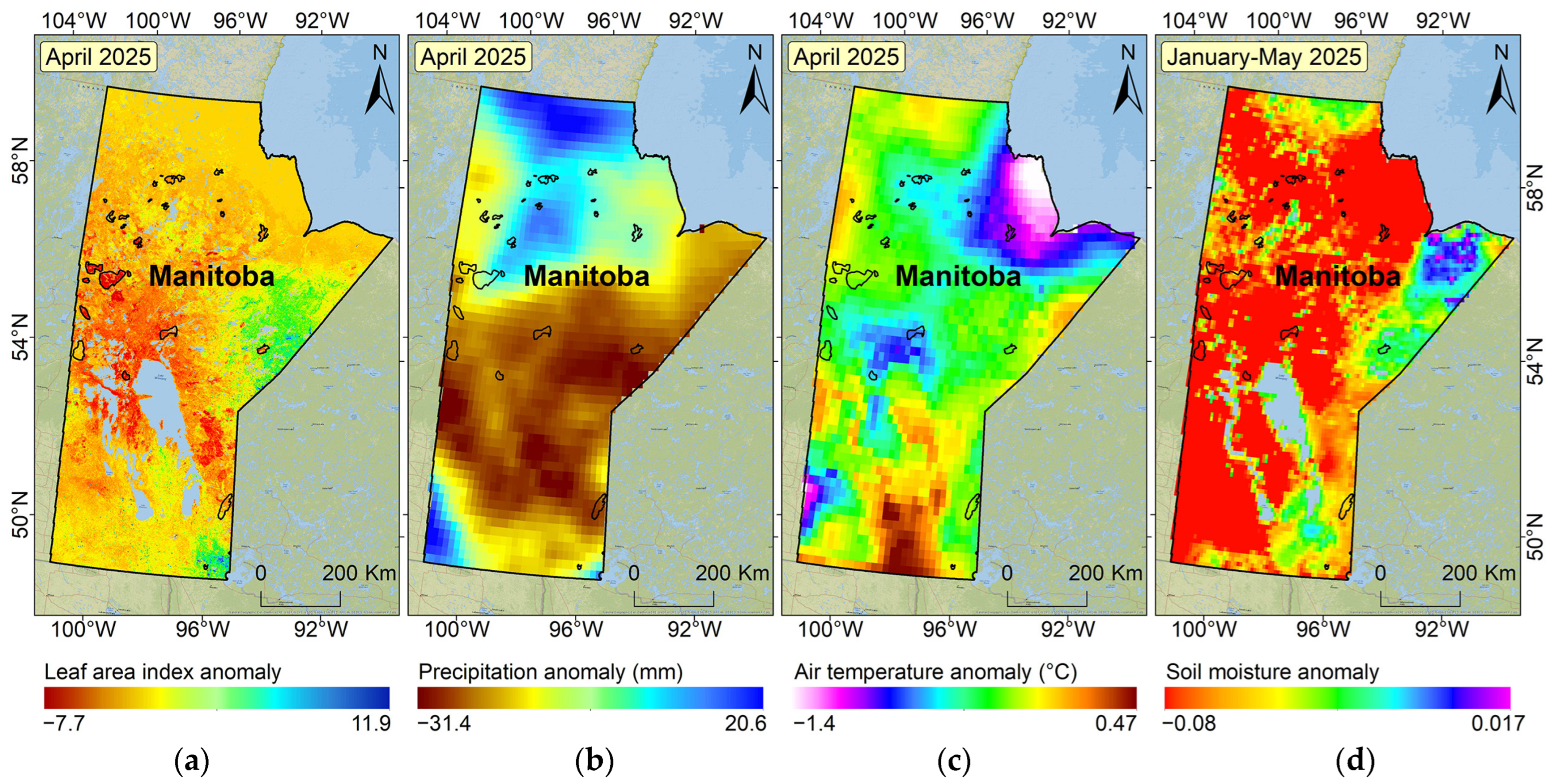
The province exhibited a mean LAI anomaly of −0.024, indicating a general reduction in vegetative greenness and canopy density (
Figure 2a). This decline in LAI reflects early signs of vegetation stress or dieback, potentially driven by water scarcity and temperature conditions during the pre-fire season. The precipitation anomaly averaged −7.6 mm, suggesting a province-wide deficit in rainfall relative to the climatological norm. The central and southern regions were particularly affected, as evident in the anomaly map, which shows extensive zones in brown and yellow, signaling significantly drier-than-normal conditions (
Figure 2b). Such early-season dryness leads to rapid fuel desiccation, particularly in fine fuels like grasses and small shrubs, which are critical to initial fire ignition and spread. Although not extreme across the province, air temperature anomalies display positive deviations, particularly in southern Manitoba (
Figure 2c). These warmer-than-average patches are crucial, as they likely accelerated snowmelt and evaporative losses in April, reducing residual soil moisture ahead of the critical fire-prone period in May. In contrast, the soil moisture anomaly was among the most negative in the historical record for early 2025 (–0.013), indicating subsurface moisture levels were considerably below the long-term average. A negative anomaly in this context reflects a relative deficit in soil water content compared to the 2003–2025 climatology. The spatial distribution reinforces the fact that vast areas of southern and central Manitoba—where most of the fires occurred—exhibited strongly negative anomalies (
Figure 2d). This suggests that cumulative soil moisture deficit played a major role in preconditioning the landscape for ignition and fire spread. Despite localized patches of neutral or slightly positive values in the far north and east, the overall spatial pattern clearly reflects widespread dry conditions in fire-prone zones.
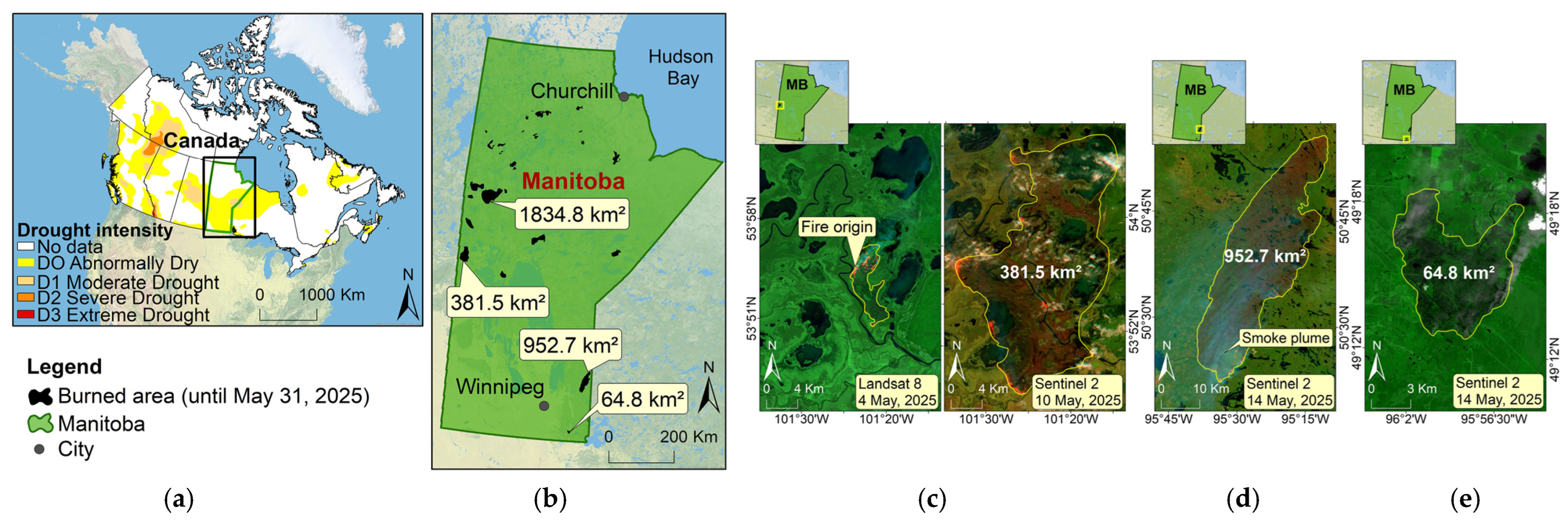
Analysis of April Anomalies Related to Fire Conditions in Manitoba
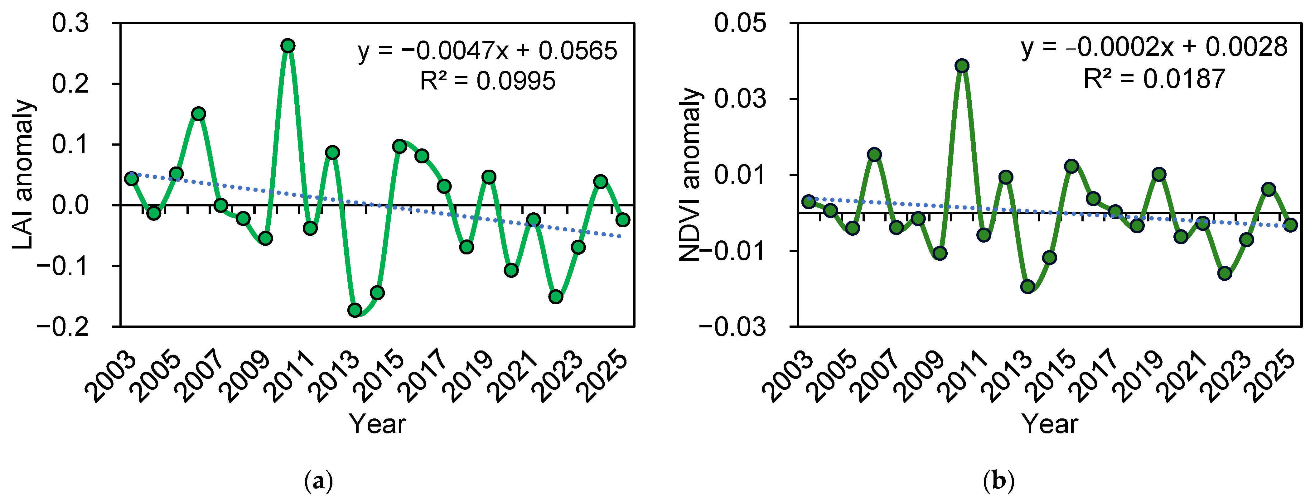
The LAI anomaly data (2003–2025) exhibit stronger interannual deviations compared to NDVI, with a notably negative anomaly in 2025 (−0.0241), consistent with limited leaf development during April (
Figure 3a). Peaks in LAI (e.g., 2006, 2010, and 2015) correspond to years with higher spring greenness, while significant troughs (2013, 2014, and 2022) are associated with dry Aprils, reinforcing the sensitivity of LAI to spring precipitation and temperature regimes. The NDVI anomaly time series (2003–2025) reveals moderate interannual variability, with pronounced vegetation stress events notably in 2013, 2014, and 2022 (
Figure 3b). The 2025 anomaly (−0.0032) is close to neutral but follows several years of fluctuating productivity, suggesting possible cumulative vegetation stress or delayed recovery from previous droughts. The precipitation anomaly series (2003–2025) highlights frequent negative anomalies in recent decades, with particularly dry Aprils in 2008, 2018, and 2023 (
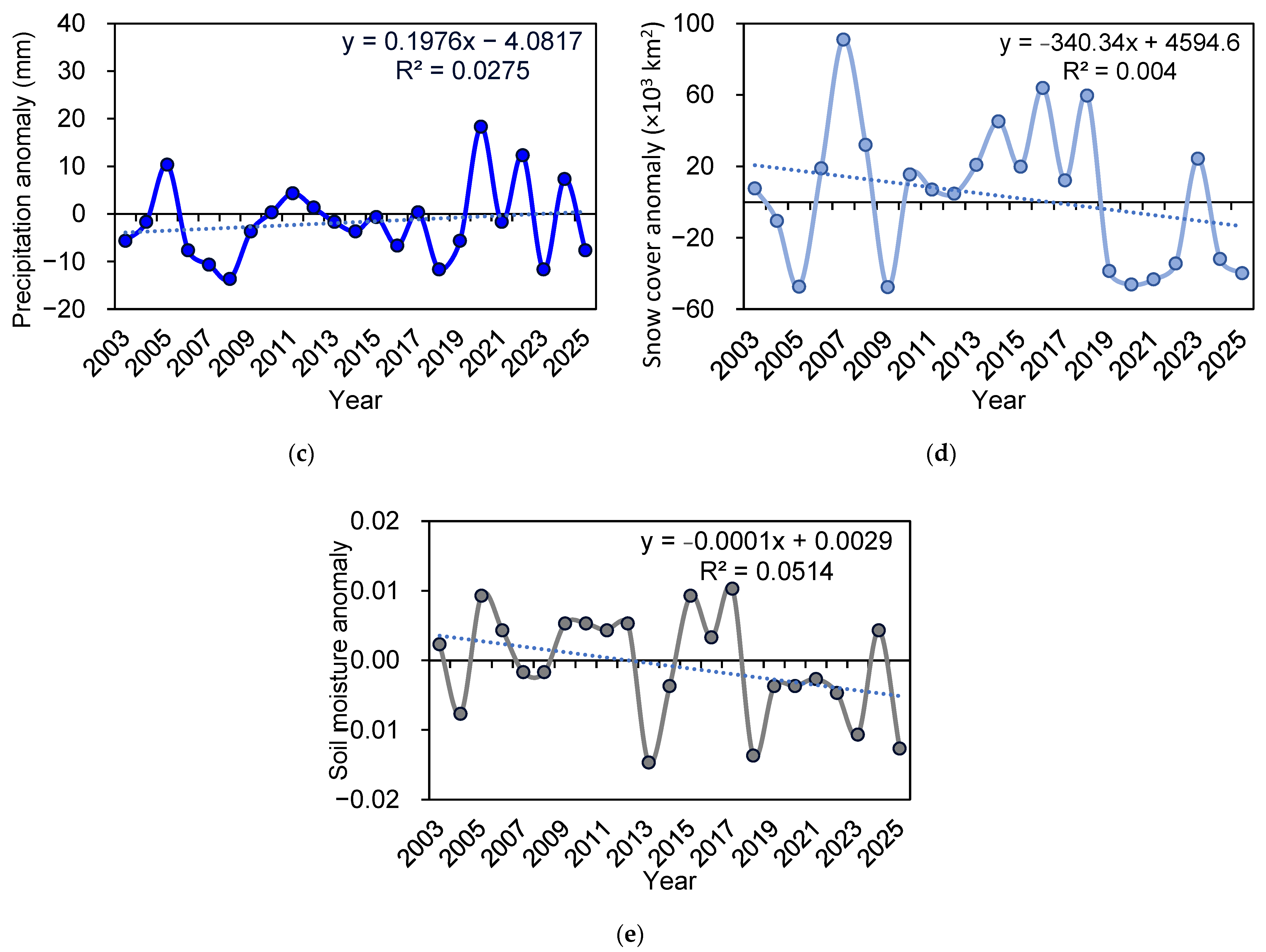
Figure 3c). The 2025 anomaly (−7.67 mm) aligns with these dry episodes, indicating a persistent trend of April dryness that may have long-term implications for vegetation regeneration and fire susceptibility in spring. Furthermore, snow cover anomalies (2003–2025) demonstrate significant variability, with large deficits in 2005, 2009, and 2020, and surpluses in 2007, 2016, and 2018 (
Figure 3d). In 2025, a snow cover anomaly of approximately −39,939 km
2 points to limited snow retention into April, likely accelerating ground exposure and preheating of fuels before the fire season. This reduced snow insulation, combined with dry and stressed vegetation, likely amplified the vulnerability of Manitoba’s landscape to ignition. Fluctuations in the El Niño–Southern Oscillation (ENSO) may be one of the factors contributing to the recent decline in snow cover extent [
9]. Soil moisture anomalies exhibit high interannual variability with several negative outliers (e.g., 2013, 2018, and 2025). Notably, the anomaly for 2025 (−0.0127) is among the most negative in the entire record. This suggests that soil conditions in early 2025 were unusually dry, likely contributing to increased fire susceptibility. This pronounced soil moisture deficit appears to be primarily driven by two key factors: an exceptional precipitation shortfall and unusually low snow cover or early snowmelt during April 2025, both of which limited soil water recharge at the start of the fire season. Although the regression line has a low coefficient of determination (R
2 = 0.002) and is not statistically significant (
p > 0.1), the presence of repeated negative anomalies in recent years may indicate more frequent dry springs. These dry soil conditions could play an important role as cumulative predisposing factors for early-season wildfire activity in boreal landscapes [
10]. Although individual vegetation indicators such as NDVI do not show significant long-term declining trends, the convergence of moderate negative anomalies in NDVI, LAI, precipitation, and soil moisture during early 2025 suggests a form of cumulative environmental stress. This form of stress arises not from a persistent trend in one variable but rather from the simultaneous occurrence of multiple below-average conditions during a critical pre-fire window. Such compounding effects may not be evident in single-variable time series but can still elevate fire susceptibility [
11,
12,
13], particularly in boreal ecosystems during early spring. Taken together, these indicators suggest that the fire outbreak in May 2025 occurred within a broader climatic context marked by recurring spring drought, declining snow cover, and vegetation stress—factors that collectively predispose the region to increasingly severe and earlier fire seasons.
To investigate whether long-term anomalies in environmental variables are linked to increased fire activity, we conducted a multiple linear regression analysis using precipitation, soil moisture, snow cover, NDVI, and LAI anomalies as predictors of burned area for the period 2003–2025. The model demonstrated limited explanatory power (R2 = 0.271; Adjusted R2 = 0.056) and was not statistically significant (F (5, 17) = 1.26, p = 0.325). None of the individual variables were significant predictors (all p > 0.1). Residual diagnostics showed no major violations of assumptions: residuals were approximately normally distributed (Omnibus p = 0.164), independent (Durbin–Watson = 2.02), and visually homoscedastic. However, the high condition number (13,700,000) indicated potential multicollinearity among predictors.
These results suggest that variations in annual burned area are influenced more by short-term interannual variability than by persistent trends in individual environmental variables. While the regression results do not support a strong linear relationship, they highlight the challenges in detecting gradual or compound effects through single-variable models.
Nevertheless, the convergence of moderate negative anomalies across NDVI, LAI, precipitation, and soil moisture during early 2025 suggests a form of compound environmental stress. This stress does not arise from persistent trends in individual indicators but from the simultaneous occurrence of multiple below-average conditions during a critical pre-fire period. Although not statistically significant in isolation, such compounding anomalies may still increase fire susceptibility in boreal ecosystems, particularly during the early spring. To better understand the relationships between the observed anomalies and the fire activity in April 2025, a Pearson correlation analysis was performed using environmental variables and fire occurrence. For this analysis, anomalies in precipitation, snow cover, NDVI, and LAI were calculated for April 2025, while the soil moisture anomaly represents the average anomaly over the first five months of 2025 (January–May) to better capture cumulative moisture deficits leading up to the fire event. The results indicate that soil moisture anomaly exhibits the strongest negative correlation with burned area (r = −0.33, p = 0.11), suggesting that prolonged soil dryness played a particularly important role in increasing fire susceptibility. Other variables, such as precipitation (r = −0.21, p = 0.30), NDVI (r = −0.14, p = 0.51), and LAI (r = −0.13, p = 0.54), also showed weak negative correlations, although not statistically significant, indicating potential additive effects. The snow cover anomaly showed only a minimal correlation (r = −0.08, p = 0.72), which may reflect spatial variability or a delayed influence. These results highlight the role of cumulative moisture deficit as a key factor preconditioning the landscape for wildfire ignition and spread.
In addition to descriptive anomaly analysis, we performed a multiple linear regression to evaluate the combined effect of precipitation, soil moisture (averaged over January–May), snow cover, NDVI, and LAI anomalies on the observed burned area. The model showed a moderate level of correlation (R = 0.52), although the overall R2 value was 0.27 and not statistically significant (F (5, 17) = 1.26, p = 0.325). None of the predictors reached statistical significance individually (all p > 0.1). Diagnostic tests indicated no major violations of normality (Omnibus p = 0.164) or independence (Durbin–Watson = 2.02); the condition number (1.37 × 10⁷) suggested potential multicollinearity among predictors. These findings suggest that while no single variable offers a strong predictive signal, the co-occurrence of moderate anomalies across multiple variables in 2025 may have contributed to increased fire risk. This model is exploratory in nature and highlights the need for larger datasets and more sophisticated approaches to better understand compound environmental influences on wildfire activity. The limited sample size (n = 25) and natural variability in wildfire drivers likely constrained statistical power. Nonetheless, this analysis supports our qualitative findings and highlights the need for longer-term datasets and higher-resolution modeling to capture early-season fire risk.
Although the 2025 environmental anomalies appeared impactful in relation to fire activity, standardized Z-score analysis shows that these values were within expected interannual variability. Calculated Z-scores for LAI (−0.243), NDVI (−0.285), precipitation (−0.717), and snow cover (−0.994) all fall within ±1 standard deviation from the long-term mean, indicating that none of the variables represent statistical outliers. This suggests that even moderate anomalies, when occurring simultaneously, can significantly elevate fire risk in boreal regions during spring [
14]. Among all variables assessed, soil moisture in 2025 exhibited the most extreme standardized deviation (Z = −1.729), suggesting unusually dry subsurface conditions despite only moderate anomalies in vegetation and precipitation indices. Although not a formal statistical outlier, this level of soil dryness likely contributed significantly to early-season fire susceptibility, reinforcing the importance of cumulative moisture conditions in fire risk assessments.
To evaluate the spatial correspondence between environmental stress and wildfire occurrence, we extracted the mean anomaly values for the 27 burned area polygons using zonal statistics. The results indicate that fire-affected areas exhibited consistently negative anomalies in key variables, including precipitation (−8.25 mm), LAI (−1.61), and soil moisture (−0.014). The negative soil moisture anomaly suggests pre-fire dryness. These values confirm that the wildfires occurred within areas experiencing below-average environmental conditions, supporting the hypothesis that moderate, spatially coincident stressors can collectively increase fire susceptibility, even when individual anomalies are not extreme [
15,
16]. Our findings align with prior work emphasizing the role of spring snowmelt timing and vegetation recovery in modulating fire season onset [
17,
18]. However, the 2025 case demonstrates that compound moderate anomalies across multiple domains can also produce highly flammable conditions [
19]. Future research should explore how other relevant meteorological and biological factors interact with moderate anomalies to influence fire ignition and spread. Incorporating these variables into compound stress frameworks could improve our understanding of early-season wildfire risk.


