Review

Danube River: Hydrological Features and Risk Assessment with a Focus on Navigation and Monitoring Frameworks

1
Mechanical Engineering Department, Dunarea de Jos University, 800008 Galati, Romania
2
REXDAN Research Infrastructure, Dunarea de Jos University of Galati, 111, Domneasca Street, 800201 Galati, Romania
*
Authors to whom correspondence should be addressed.
Earth 2025, 6(3), 70; https://doi.org/10.3390/earth6030070
Submission received: 25 April 2025 / Revised: 20 June 2025 / Accepted: 27 June 2025 / Published: 2 July 2025

Abstract

Danube River represents a critical axis of ecological and economic importance for the countries along its course. From this perspective, this paper aims to assess the most significant characteristics of the river and of its main tributaries, as well as its impact on the environmental sustainability and socio-economic development. Navigation and the economic contribution of the Danube River are the key issues of this work, emphasizing its importance as an international transport artery that facilitates trade and tourism, and develops the energy industry through hydropower plants. The study includes an analysis of the volume of goods transported from 2019 to 2023, as well as an analysis of the goods traffic in the busiest port on the Danube. Furthermore, climate change affects the hydrological regime of the Danube, as well as the ecosystems, economy, and energy security of the riparian countries. Main impacts include changes in the hydrological regime, increased frequency of droughts and floods, reduced water quality, deterioration of biodiversity, and disruption of the economic activities dependent on the river, such as navigation, agriculture, and hydropower production. Thus, hydrological risks and challenges are investigated, focusing on the extreme events of the last two decades and the awareness of their repercussions. In this context, the national and international institutions responsible for monitoring and managing the Danube are presented, and their role in promoting a sustainable river policy is explored. Methods and technologies are shown to be essential tools for monitoring and prediction studies. The Danube includes an extensive network of hydrometric stations that help to prevent and manage the most significant risks. Finally, a SWOT (Strengths, Weaknesses, Opportunities, and Threats) analysis of the development of the hydrological studies was conducted, highlighting the potential of the river.

1. Introduction

Climate change is a challenge of our century. It has a direct impact on the environment and the global economy [1,2,3,4]. Its effects are defined by rising temperatures, increased precipitation, a higher frequency of extreme events, melting glaciers, rising sea levels, and a direct impact on water resources [2,3]. By interconnecting ecosystems and economies, climate change is thus not only affecting regions with high frequency but also generating a chain of effects at a global level [4].
River dynamics is another sector affected by climate change, which directly affects the economy and generates challenges in various areas, such as water transportation and agriculture [5]. The increasing frequency of floods and droughts creates challenges in protecting infrastructure and human settlements, hydropower production, agriculture, and shipping. Thus, solutions must be adopted and policies developed to prevent natural disasters [6,7,8].
The Danube River, the second-longest river in Europe in terms of length, is an important waterway with a significant economic impact on the regions it crosses [9]. Climate change affects the dynamics of the Danube, both economically and ecologically, due to droughts, floods, or variations in flow [10,11,12]. Thus, hydrological studies are essential for river management, to develop adaptation strategies to new climatic conditions, and to prevent natural hazards. They have a role in understanding the basin’s dynamic changes and its sustainable management. Also, continuous monitoring through hydrometric stations provides essential data for warning systems, water resources planning, flood prevention, and navigation safety.
Hydrological hazards [13,14,15,16], including floods, droughts, pollution, and other extreme events, are a constant challenge for the Danube. They have severe consequences for their ecosystems, economy, and riverside communities. Hazards are closely linked to climate variability, urbanization, and industrial development in riparian areas. Understanding and mitigating these phenomena requires robust real-time monitoring mechanisms capable of capturing sudden changes in water level, flow, or quality. High-accuracy hydrological data allows early detection of potentially dangerous situations and provides the scientific basis for activating warning and intervention protocols. In this context, this paper systematically addresses the hydrological characteristics of the Danube and assesses the associated risks, with a focus on navigation and the effectiveness of the current monitoring framework.
The river’s economic impact on the riparian regions is a complex subject that needs to be analyzed from several perspectives, such as transport, agriculture, tourism, and hydropower production [17].
Inland waterway transport and trade [9,18,19,20] is a major commercial artery linking Central and Eastern Europe. Unlike road or rail transport, it reduces costs and offers a sustainable energy solution. It transports a wide range of goods, such as grain, raw materials, and petroleum products, but it is also used as a waterway for passengers. Cruises on the Danube contribute considerably to the economy and the existence of ecotourism areas such as the Danube Delta [21,22,23,24].
The Danube also contributes to supporting agriculture [25,26] through irrigation, especially in arid or drought-affected regions. It helps to fertilize soils to produce cereals, vegetables, fruits, and other crops. It also contributes to the local economy by supporting fisheries and aquaculture activities [24,27].
The river’s position and considerable flow make it suitable for power generation [28,29,30,31], contributing to the region’s energy security. Although it requires biodiversity protection measures, the environmental impact is significantly lower than that of a renewable energy source. The Iron Gates I and II hydropower complexes [31] bring significant amounts of energy to Serbia and Romania, but to maximize the benefits, it is necessary to modernize the equipment and implement biodiversity protection technologies.
Hydrological studies [32,33,34] can help understand river behavior, identify environmental and economic risks, and contribute to developing sustainable policies to ensure the responsible and efficient use of river resources. These studies can also help with disaster prevention, environmental protection, and regional development.
This paper aims to study the characteristics of the Danube and its main tributaries to provide a detailed picture of the river’s hydrological, geographical, and ecological aspects. It emphasizes the importance of hydrological studies and their impact on economic development and environmental sustainability. The assessment of the effects of extreme hydrological events (floods, droughts) on riparian populations and the economy has also been studied. Another key point of the paper is the presentation of the main institutional and technological strategies that riparian countries are implementing for monitoring and managing the Danube, emphasizing forecasting tools, early warning systems, and transboundary cooperation. All these aspects will be the focus of this paper, which aims to deepen the knowledge about the Danube’s crucial role in the regional and global context. Although several studies exist on Danube hydrology [14,24], navigation conditions [9,11,19,20], economic development [9,18,19], or hazards [13,14,15,16], they have yet to be examined within a cohesive framework. This paper asserts the necessity of providing a comprehensive overview of these perspectives.
Furthermore, in light of climate change, water level fluctuations significantly impact navigability. This study also underscores the urgent need for developing and implementing real-time monitoring systems to enhance navigation management and prevent disruptions in waterway transportation.
Therefore, this paper has a thematic synthesis character and analyzes relevant institutional sources and technical reports in order to outline an integrated framework on the challenges and development directions related to the Danube River.

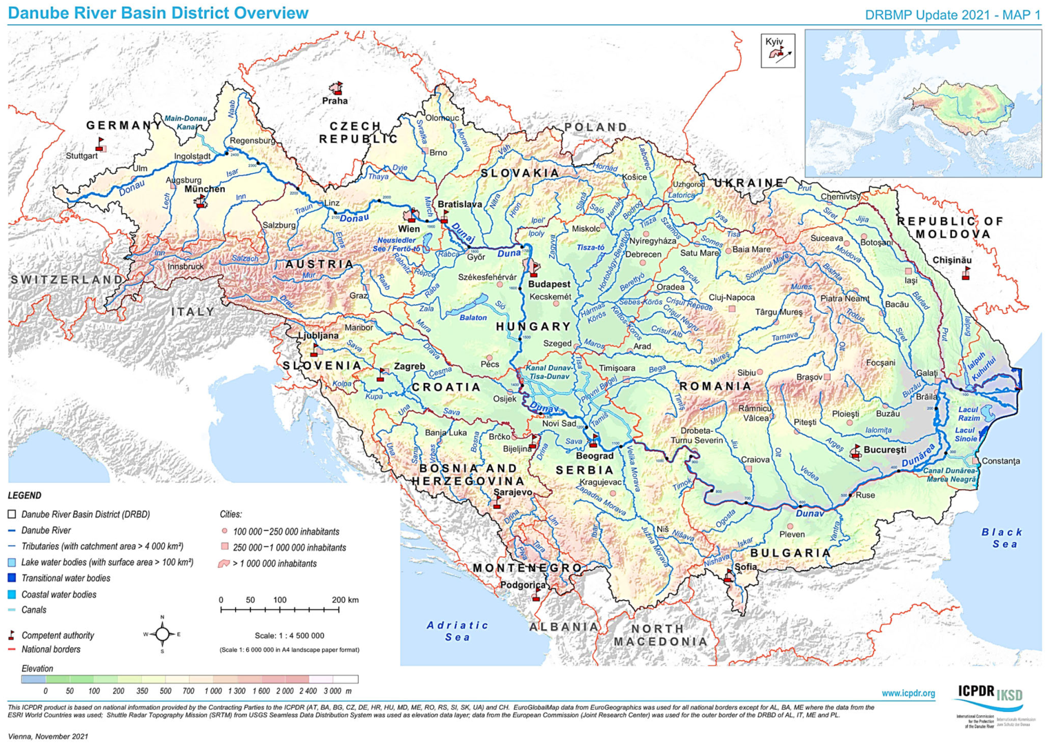
2. Characteristics of the Danube

The Danube originates in Germany, runs through ten countries and four capitals, and is an essential waterway for Central and Eastern Europe [35,36,37,38]. The Danube flows from west to east, crossing several European countries. In Romania, the number of kilometers along the river descends from the entrance to the Black Sea. The point of reference for this numbering is Sulina, which represents Mile 0. Distances along the Danube are thus expressed in kilometers from this endpoint, increasing as one moves upstream to the west. It is divided into three major sections: the Lower, Middle, and Upper Danube, whose course is illustrated in Figure 1 [39].
The Danube River has an essential economic, ecological, and cultural role due to the diversity of the regions it crosses [24,37]. The Upper Danube flows through Germany, Austria, and Slovakia with a fast course, mainly due to snow melt in the Alps, and displays many dams and hydropower plants along its course. The Middle Danube is an important international trade corridor from Bratislava to the Iron Gates, Romania. In this section, many large tributaries, such as the Sava and the Tisa, contribute to ecological diversity, essential for aquatic ecosystems and migratory birds. Comparable to the Middle Danube, the Lower Danube is also vital for international trade, given the Sulina Channel connecting the Black Sea to the Danube. This portion of the sector is also home to the Danube Delta, a UNESCO-protected reserve that provides a habitat for a wide range of birds, fish, aquatic plants, and serves as an environmentally valuable ecotourism and conservation area [24,40,41].
The Danube Basin represents climatic variability [14] due to its orientation, geographical position, and diversified relief, while these variations influence its biodiversity and ecosystems. The Upper Danube is characterized by high precipitation throughout the year, cold winters, and mild summers, having an Atlantic climate with continental influences. The Middle Danube has a temperate continental climate with lower precipitation and hot and dry summers. The Lower Danube has an environment similar to the Middle Danube but with continental influences that cause high rainfall, cold winters, and hot summers. The Danube Delta has a transitional climate between continental and Black Sea-influenced, with milder winters and summers with moderate sea breezes but higher humidity. The highest mean annual temperatures are found in the lower and middle Danube, and the highest maximum yearly precipitation is in the western and southeastern Danube.
The main characteristics of the Danube are presented in Table 1. With a length of approximately 2850 km, the Danube has numerous tributaries that contribute to the river’s flow and impact the economy and ecosystems of the regions concerned [10,24,42,43]. The main tributaries are detailed in Table 2 in terms of length, countries crossed, discharge, average flow, and relevance. The tributaries Inn and Morova [14,44] belong to the Upper Danube, having a high flow and influencing water dynamics, while the Siret and Prut, present in the Lower Danube, are an essential source of potable water and have a significant part in irrigation. The Sava is a major tributary, being an important waterway and helping agriculture in the regions it crosses [26,45]. Although shipping is not significant on the Tisa [46,47], it contributes indirectly to the flow of goods by supplying the Danube.
In addition to examining the parameters of the Danube and its tributaries, the associated drainage areas must be investigated to fully understand the hydrological characteristics. Drainage areas are the geographic areas that collect the waters that reach the river and are essential for flow calculation and risk modeling of floods, droughts, or nutrient transfer [48,49]. Table 3 shows the major geographical and drainage areas and their descriptions to understand the hydrological regime.
The Upper Danube crosses mountainous regions with high flow and low pollutant input, which is ideal for hydropower. In contrast, the Middle Danube passes through agricultural and urban areas of the Pannonian Plain, with a constant flow but exposed to the risks of pollution and flooding. The largest drainage area is the Lower Danube, which has a slow flow and the low-lying regions, and is of significant ecological importance.
The Inn and Drava are tributaries in alpine areas, with mixed regimes, significant clean water inflow, and intensive hydropower use. The Sava is the most critical southern tributary, with a complex regime and urbanized and agricultural territories. The Tisa also flows through agricultural and industrial regions and contributes significantly to water volume and nutrient loading. Agriculture, seasonal flooding, and diffuse pollution influence tributaries in Romania and Moldova, the Olt, Siret, and Prut.
Drained areas are an indicator of hydrological importance. For example, the Tisa and Sava contribute substantially to the volume of the Danube. Knowledge of basin structure helps in sustainable resource planning, flood prevention, and the protection of aquatic ecosystems. In climate change and socio-economic development, analyzing drainage areas provides the basis for hydrological and ecological modeling (such as adaptation of the RIVERSTRAHLER model [48]).

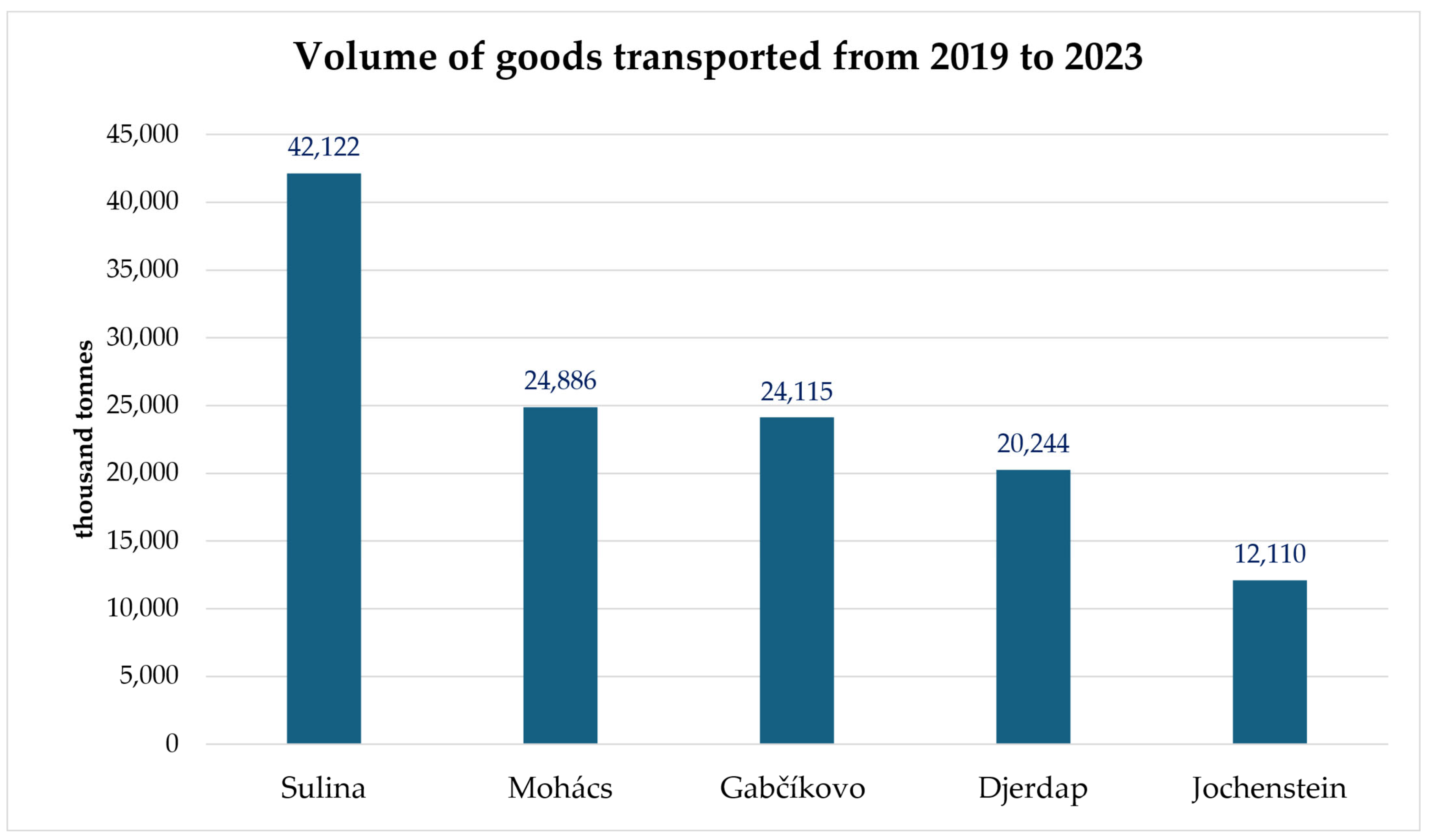
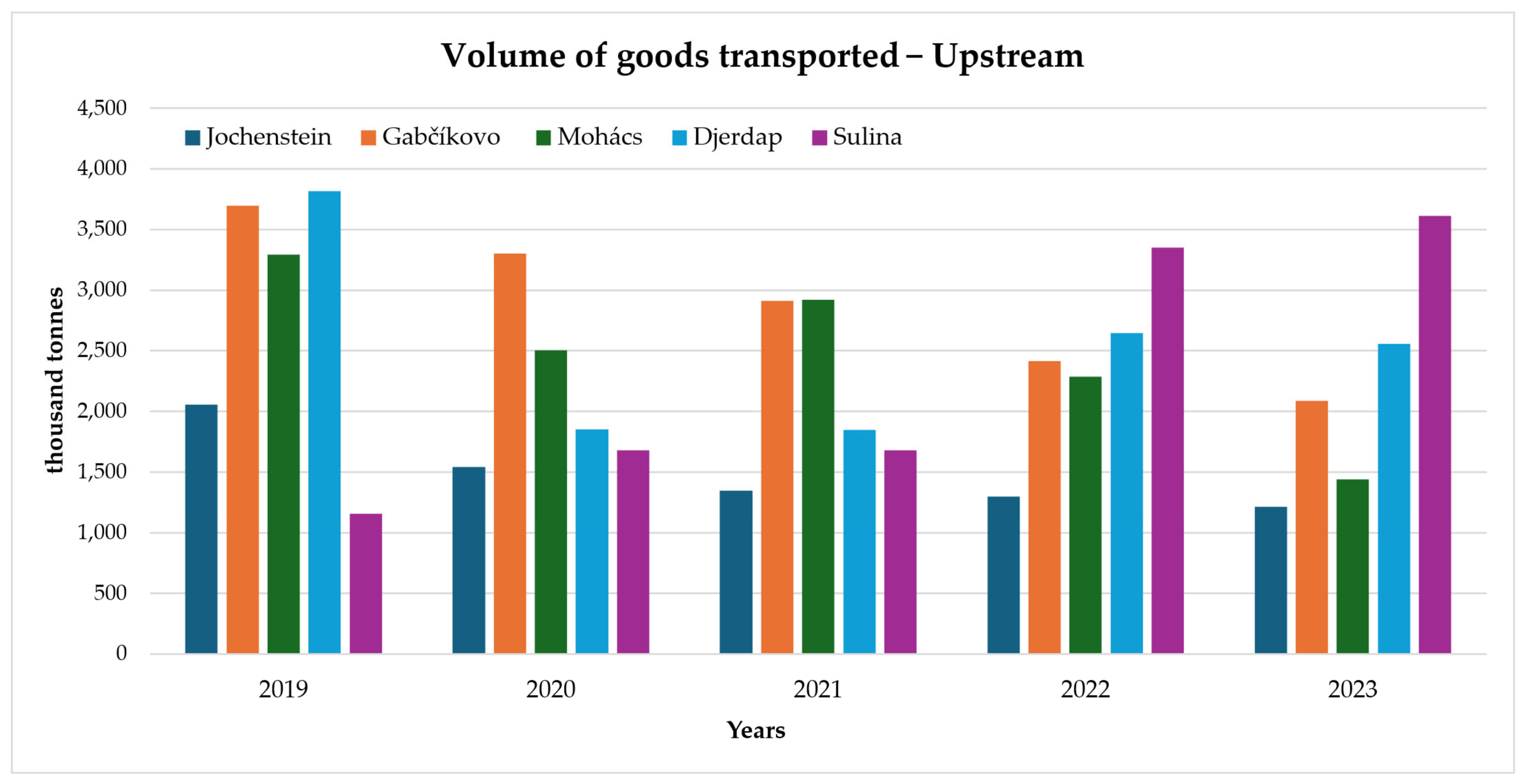
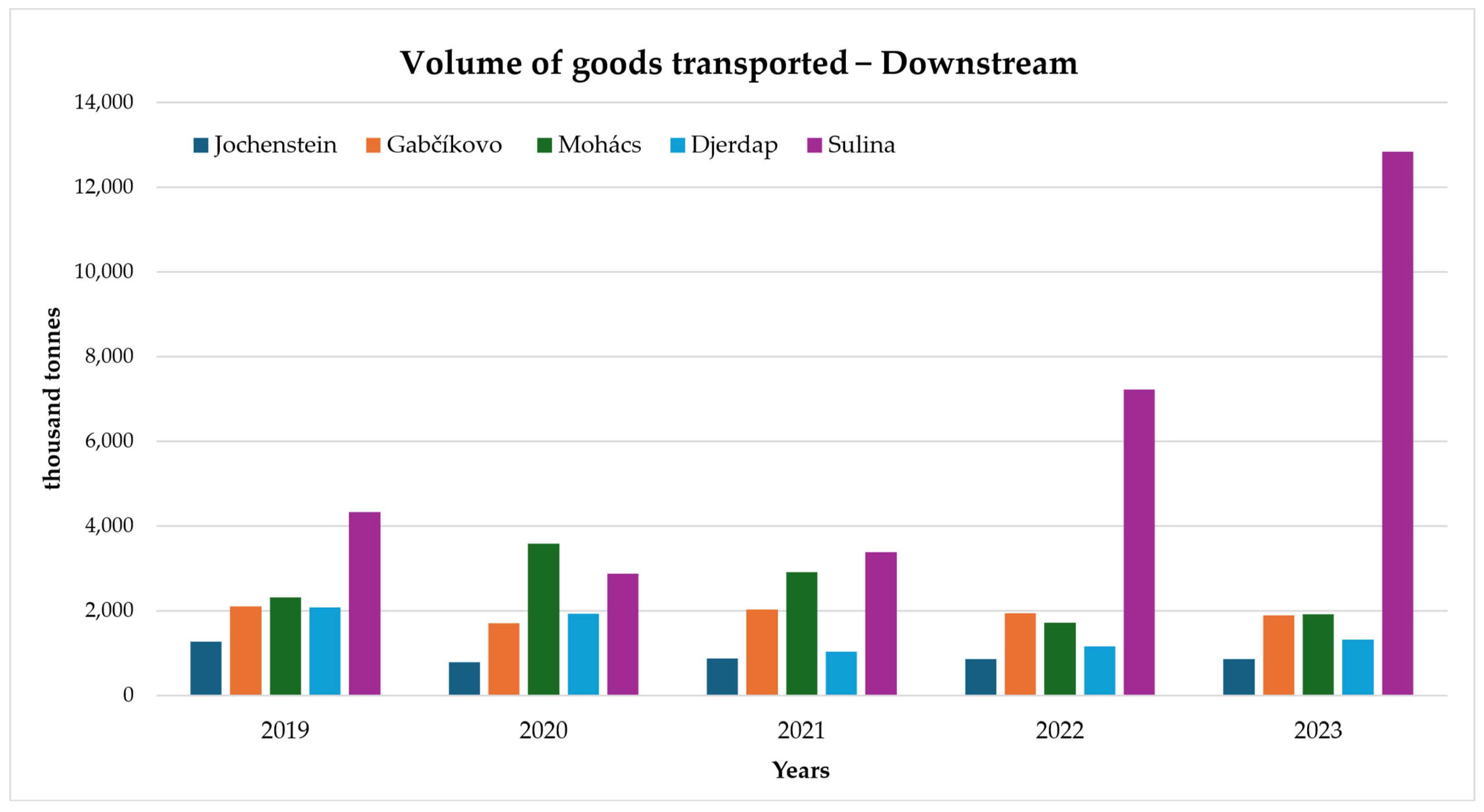
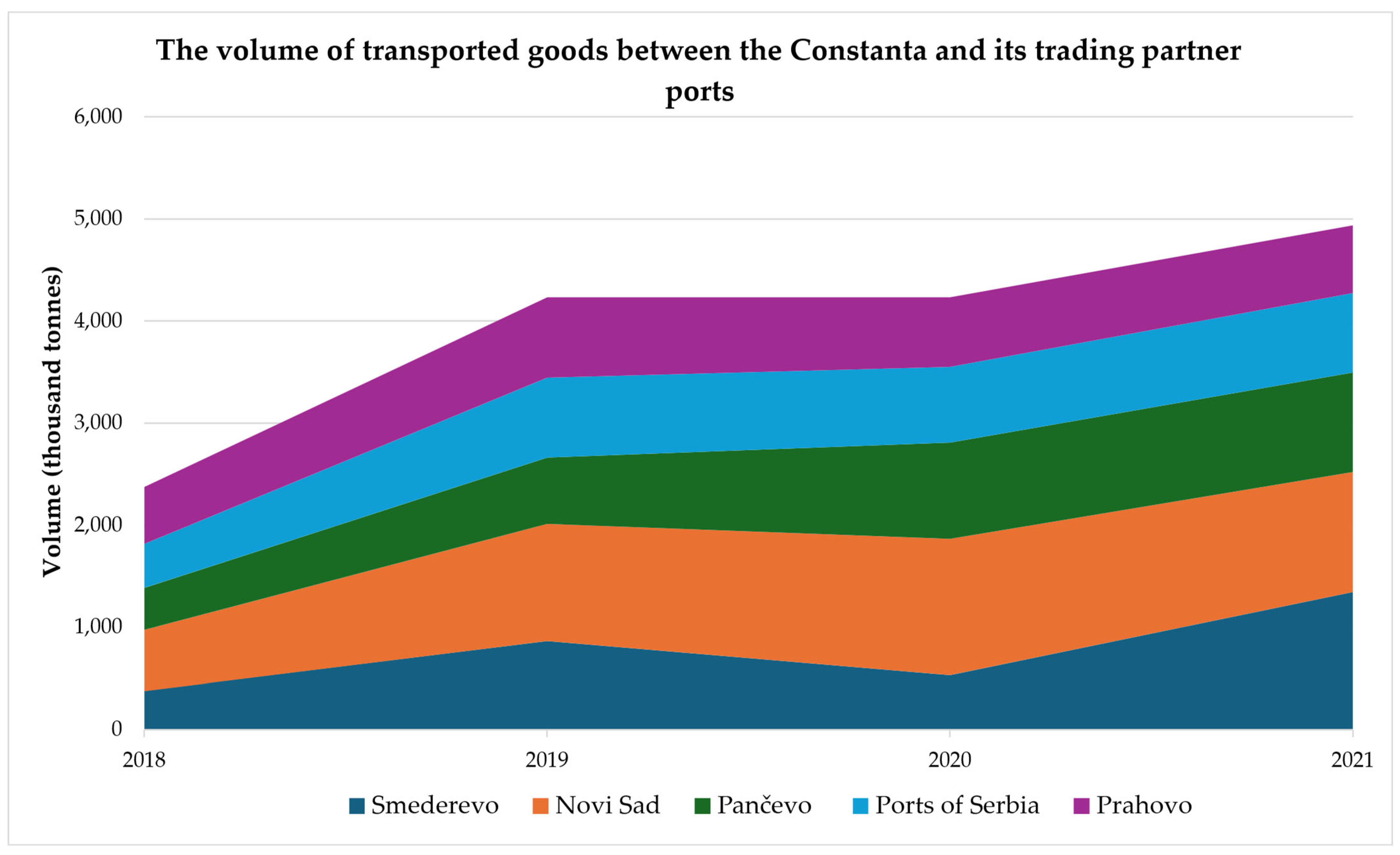
3. Navigability and Economic Contribution

The Danube represents a vital transportation route [9,38,50,51] for passengers and goods in the regions it crosses. It is the most advantageous method of transportation connecting countries such as Romania, Bulgaria, Serbia, Slovakia, Hungary, Austria, and Germany.
On a European level, the Danube establishes connections and creates transport corridors that facilitate mobility and trade. The most significant transport corridors on the Danube are the Danube-Black Sea Canal [20,25,52], the Rhine–Main–Danube Canal [53,54,55,56,57], and the Pan-European Corridor VII [21,57,58].
The Danube-Black Sea Canal [19] facilitates the transportation of goods between the Middle East and Asia, substantially reducing transportation distances, and has transformed Romania into a central river transport hub. The canal opened in 1984 [59], has a total length of 64.4 km, and is navigable for vessels up to 5000 tons. It has two main branches, the Poarta Alba-Midia Navodari Canal linking the ports of Midia [19,60] and Navodari with the Danube, and the central canal linking the port of Constanta with Cernavoda. In addition to reducing distance and logistics costs, it generates jobs and supports industry and agriculture by facilitating exports. The main goods transported are petroleum products to the Western and Eastern European markets, minerals to Germany and the Netherlands, and cereals to Asia and the Middle East.
Pan-European Corridor VII is about 2850 km long [61] and links the Black Sea to Central Europe. It also connects with two other road and rail corridors [62], such as Corridor IV, which links Eastern and Central Europe, and Corridor IX, which crosses Europe from North to South.
The Rhine-Main-Danube Canal is 171 km [54,56,63] long and enables navigation from the North Sea to the Black Sea. It allows the transportation of bulk cargo containers, oil products, and other goods. The canal is also a hub for cruises and plays a vital role in tourism. Due to the differences in elevation between the water basins, the canal hosts 16 locks that make year-round navigation possible.
Navigation on the Danube presents a series of specific characteristics due to a variety of factors, such as wind climate [33,36,64,65], and wave climate [65,66,67], but also the hydrodynamic and geomorphologic characteristics of the basin [36,68,69]. Accordingly, to ensure safe voyages, a set of rules has been imposed by several international and national bodies, such as the Danube Commission [70], the Romanian Naval Authority [71], the EU Strategy for the Danube Region (EUSDR) [72], and many others.
The main navigation rules are presented in Table 4. Depending on each sector, the maximum speed, the necessary safety measures, and navigation in low-visibility conditions or narrow areas have been specified. Furthermore, conditions for loading, special rules for passenger vessels, and priority of passage are determined.
Apart from the general rules, there are special rules for different sectors. For example, due to its hydrographic characteristics and traffic volume, the sector between Braila and Sulina is subject to a particular set of rules [73], as it is crossed by both river and sea vessels. Due to the variable depth and sandbanks in this sector, ships must follow the routes set by the port authorities to avoid hazards and protect the environment.
Water level variation is an essential factor affecting navigation on the Danube. Hence, records are kept throughout the year. Along the river’s entire length, hydrometric stations are managed by the national authorities for each riparian country, such as the Galati Lower Danube River Administration for Romania [74]. Thus, it is possible to access water level, temperature, and variation data for 24 h, 48 h, 72 h, 96 h, and 120 h, depending on location and kilometers on the Danube. In addition, the expected water levels for the next two days, minimum depths, ice reports, and a hydrometeorological bulletin are available.
From an economic point of view, studies [75,76,77] have shown regional differences. The western part of the basin experiences a uniform development, while in the eastern part, due to the post-socialist transition, the differences have increased. Development and improvement of water transport are affected by economic conditions. Nevertheless, developed countries in Europe contrast with less developed countries in South America or Africa, which have lower economic development and less developed infrastructure [78].
Following, based on the data provided by the Danube Commissioning [70], the volume of goods transported from 2019 to 2023 in the main bordering points was studied. The shipping from 2019 to 2023 was influenced by several factors, some of them damaging, such as the COVID-19 pandemic (in 2020 there was a temporary decrease in shipping traffic due to the pandemic), hydrological conditions (in 2022 the water level was very low due to drought), but also some positive factors, such as the increase in transport demand, modernization of ports, and improvement of infrastructure.
According to Figure 2, during the mentioned period, the highest volumes of goods were registered in Sulina, 42122 thousand tons, followed by the port of Gabčíkovo in Slovakia and the port of Mohács in Hungary. Regarding transportation directions, Figure 3 and Figure 4 illustrate the volume of goods during the five years studied.
The COVID-19 pandemic [79,80] that started to spread to Europe in March 2020 harmed transportation, as seen in the trend in goods volumes compared to the previous year. The recovery began in the second half of 2021, but the increase has been gradual due to changes in health safety measures.
In 2023, a massive increase in the volume of goods transited through Sulina can be observed due to the war between Russia and Ukraine, which has led to the redirection of flows from Ukraine to Romania, especially the transportation of grain [81,82,83,84]. This increase in traffic has brought benefits for Romania’s economy, but there have also been logistical problems, pressuring regional infrastructure. However, the conflict between the two countries has turned the Danube into a central navigation hub for Ukrainian exports due to the blockade imposed on the Black Sea ports.
Between 2019 and 2023, a significant diversity of goods was transported on the Danube. The main categories of goods transported were agricultural products, honey and metallurgical products, petroleum products, fertilizers and chemicals, construction materials, metals and metal products, and finally, containerized goods and vehicles. Grain transport has increased significantly, especially since 2022, when Ukrainian ports on the Danube became major alternative routes for agricultural exports, in the context of the blockade of Black Sea ports, due to the conflict between Russia and Ukraine. Iron ore is among the most transported goods in the Middle and Upper Danube sector, especially to Austria, Hungary, and Serbia, which supply the regional steel industry. Petroleum and metal products represented significant river traffic, supporting regional sectors.
The Danube is home to a range of key ports for international shipping [78,85,86,87] that ensure the transportation of goods across Europe and beyond. Regensburg, a major port and one of the oldest cities in Germany, provides connectivity with the Rhine-Main-Danube canal. Due to its geographical position, Belgrade, the capital of Serbia, provides the connection between the Lower and Middle Danube as a trade route and a destination for luxury cruises.
Constanta is one of the most important ports on the Danube in terms of ship traffic, capacity, and infrastructure. It is also the largest port in Romania. Through the Danube-Black Sea Canal, it facilitates naval transportation and ensures a continuous flow of goods. The goods transported through this port range from cereals to petroleum goods, chemical goods, industrial products, and food products.
The volumes of goods transported to the top five destination ports in 2018–2021 are shown in Figure 5. For the mentioned period, Novi Sad received the most goods, with a volume of 4258 thousand tons, mainly cereals (wheat, corn), petroleum products, ores, and construction materials. The next destination port is Smederevo, which has a total volume of 3122 thousand tons, followed by Pancevo, which has a total volume of 2984 thousand tons, representing two crucial ports for oil and chemical products.
Therefore, navigation on the Danube is a complex activity that brings many advantages to the Riparian countries. Due to increasing market demand year after year, waterways and ports are constantly evolving and developing to carry out river activities efficiently and sustainably.

4. Hydrological Risks and Challenges on the Danube
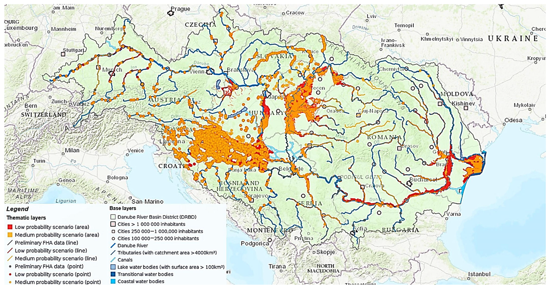
The Danube River is an essential pillar for the economy and development of the local communities it crosses. Still, it faces many hydrological risks and challenges amplified by human activities, environmental requirements, and climate change.
The main hydrological risks and challenges, presented in Table 5, are floods and droughts, affecting agriculture, river transportation, and ecosystems. Another critical factor is pollution, which affects aquatic biodiversity and water quality. The construction of dams and canals, which can reduce sedimentation and affect the habitat of marine species, also affects biodiversity.
Freezing and ice formation on the Danube [69,88,89,90] can affect navigation and ecosystems in the riparian areas. There is also a risk of ice accumulation in narrow places, which can block the flow of water and thus cause spills and damage. Although this is a seasonal phenomenon that does not occur every year, it is necessary to monitor the hydrological conditions and take preventive measures to keep the river navigable and safe.
Sedimentation is a natural process influenced by human activities, water speed, and flow. Although sedimentation is not inherently harmful, disturbances to its natural flow, such as barriers to sediment transport, can lead to significant ecological consequences. It plays a decisive role in ecosystems [91], and its negative impact can be reduced through monitoring, protective measures, and ecological restoration to ensure a healthy environment. The construction of the Iron Gates [92] has significantly reduced sediment transport, affecting the natural sediment transport processes to the Danube Delta and the Black Sea and drastically changing the basin dynamics.
Although challenging, international cooperation is necessary for river management. Collaboration and cooperation on environmental protection, risk management, and economic development provide a common framework for the basin’s sustainable development and meeting common threats.
Climate change is also significantly affecting the Danube, leading to variations in the hydrological regime and an increase in extreme events such as droughts, storms, and floods. Increases in water temperature and decreases in flow may also result in lower oxygen in the water, negatively affecting aquatic ecosystems. According to the International Commission for the Protection of the Danube River (ICPDR) [38], climate models project a decrease in summer precipitation and an increase in temperature, reducing river flow during warm seasons and intensifying hydrological extremes. Also, according to the European Environment Agency (EEA) [93], the Danube region is experiencing a rising trend of more frequent and intense extreme floods and prolonged droughts. These events threaten infrastructure, agriculture, and biodiversity along the river.

4.1. Floods

Over the years, the Danube basin has been affected by numerous floods [8]. The causes of these events are multiple, but most often they occur due to heavy and persistent rainfall, snowmelt, ice, massive deforestation, changes in riverbeds, and climate change, which emphasizes the occurrence of extreme meteorological phenomena.
Flood risk along the Danube is significant in several countries, with Romania and Hungary facing the highest exposure due to extensive floodplains. The Danube Delta is also prone to flooding, especially in lowland areas where water can quickly accumulate. The hydro-engineering works during the communist period prioritized economic development, neglecting their ecological impact and sustainability [94]. Thus, infrastructure improvements are needed to reduce the risk of flooding.
At the same time, the combined use of dynamic and static flooding methods in this area [95] provides insight into the risks and prevention methods for these phenomena. The proximity of the river and the flat ground also exposes other regions of Romania to these phenomena, such as Mehedinti, Dolj, Galati, or Teleorman. For similar reasons, floods also occur in southern and south-eastern Hungary, Serbia, and Bulgaria, especially during spring and fall due to the rapid rise in water levels. Germany and Austria are particularly affected during periods of snowmelt or heavy rainfall.
In 1342, the flood known as the “Magdalene Flood” [96] demonstrated the Danube’s vulnerability to extreme events, leading to the destruction of numerous towns and villages, the loss of crops, and even human lives. According to the International Commission for the Protection of the Danube River (ICPDR) [97], major events have been investigated and detailed in Table 6 for the last 25 years.
The 2002 floods, caused by melting snow and heavy rains, significantly impacted many countries. They were devastating events, with damage amounting to 3.6 billion euros. Austria had the highest losses, and more than 10,000 houses were affected. As a result of the floods, Romania experienced significant problems with infrastructure, gas, communication, and electricity networks.
The year 2006 demonstrated the importance of preventive measures and international cooperation in avoiding catastrophic consequences, and thus, the material damage was significantly less severe. The factors that caused the flooding led to record-breaking water levels and highlighted the vulnerability to extreme weather conditions [98].
In 2010, excessive rainfall affected the entire Danube basin, and in 2013, similar events experienced record water levels, with significant economic damage. Although flood forecasting was difficult, applying preventive measures reduced the risks. At the same time, the 2013 flood [99], compared to the 2002 flood, was characterized by a persistent flood wave, leading to a longer event duration.
At the beginning of 2017, the Danube and part of its main tributaries faced problems caused by ice formation, which emphasized the importance of developing resources for the sustainable management of the basin to avoid blocking navigation or destroying existing infrastructure.
During the period 2020–2024, although significant increases in water levels were recorded, no major floods were identified, in contrast to the floods as mentioned earlier. Preventive measures and rapid interventions by the authorities helped to avoid major floods in the riparian regions. However, isolated intense floods caused by extreme weather events have underscored the continued need for early warning systems and protective measures.
From the analysis of the extreme floods, it can be noticed that they do not coincide along their entire length due to the different topographies of the regions, as well as the differences in water flow. The basin dynamics are still changing due to sedimentation, erosion, and human interventions, and thus, the use of flood routing can be a feasible and economical method [100,101,102]. Climatic changes, manifested by increases in average temperatures and wind speed [36], and the intensification of extreme phenomena remain a threat and require continuous emergency planning.
Using DanubeGIS [103], the map in Figure 6 was generated. The map shows the spatial distribution of areas at risk of flooding along the Danube River, according to the scenarios developed in the Danube Flood Risk Management Plan (DFRMP 2021 [104]). Areas with significant potential risk are highlighted, based on hydraulic modeling, and this information is essential for identifying vulnerable sectors and the basis for prevention and intervention measures at a regional scale.
Flood protection measures involve building dams and separating the floodplain from the riverbed [105]. Nevertheless, these measures negatively affect the river’s nature and ecosystems, such as reducing the width and length of the river basin and degrading the riverbed.
Although flooding remains a significant challenge, ICPDR [97], as well as other institutions, local agencies in each country (the European Environment Agency, EEA [93], WWF Danube-Carpathians Program [106], Danube Environment Forum, etc.) and international projects (Joint Danube Survey [107], Danube Flood risk, etc.), are working on flood management in the Danube area to reduce risks and protect both communities and ecosystems in the basin.

4.2. Droughts

Over the years, several severe droughts have affected agriculture, shipping, and the economy of the areas along the Danube. Although the effects of these events are not as instantly visible as those of floods or frost, they have a long-lasting effect on the economy and people’s well-being [108,109].
Droughts can be affected by climatic factors [110], such as lack of rainfall or high temperatures, and by human activities, such as the construction of dams that alter the normal flow or excessive use of water for irrigation.
Table 7 shows the most severe droughts in the Danube’s history and mentions their duration, causes, impact, and affected area. The most severe drought of the 20th century, 1947, is known for its duration and devastating effects. However, the drought of 2022 led to record highs in denarius share and was distinguished by its intensity and dramatic consequences.
Many projects [108,111,112,113,114] have been implemented to better manage drought-related problems and increase people’s awareness of their effects.
One such project is DriDanube (Drought Risk in the Danube Region) [108,113], which aims to increase drought risk management capacity, improve drought monitoring, and improve emergency response. The Interreg Danube Transnational Program has funded this project. It involves partners from several Danube basin countries working together to develop standard tools, share knowledge, and create effective drought management policies.
The European Drought Observatory (EDO) [113] is a European platform that monitors and manages drought based on satellite images, hydrological data, and climate models. In 2022, when one of the most severe droughts in Danube history occurred, this platform played an essential role in monitoring and assessing the phenomenon and helping authorities to understand its extent. It can also monitor precipitation, temperature, hydrology, and other parameters.
Another regional initiative, the Drought Management Center for Southeastern Europe (DMCSEE) project [114] focuses on drought monitoring, management, and coordination between countries in risk management.
Figure 7 generated using AQUEDUCT [115], illustrates the geographical distribution of drought risk in Central and South-Eastern Europe, covering the entire Danube catchment area. The most vulnerable areas affected by droughts, such as southern Hungary, eastern Serbia, southern Romania, and the Dobrogea region, coincide with the river’s course and are critical for transportation, irrigation, and drinking water supply. This map supports the need for integrated real-time drought monitoring systems and standard policies for water resources management in the Danube riparian countries, especially in climate change context, which is increasing the frequency and severity of droughts.
Thus, droughts have had a devastating impact over time, and constant monitoring using satellite data and hydrological analysis is essential to issue early warnings and to manage adaptation and response measures.

5. Institutions for Monitoring and Management of the Danube

A variety of national and international organizations are involved in the monitoring, analysis, and management of the Danube River, reflecting its strategic and ecological importance. Their role is essential for the prevention and mitigation of extreme events and for maintaining environmental balance. Table 8 presents the leading institutions involved in river monitoring and management.
The International Commission for the Protection of the Danube River (ICPDR) [97] coordinates efforts to protect and sustainably use the river’s resources and monitors water quality. This organization also collaborates with riparian states and supervises environmental biodiversity and risks.
Danube Region (EUSDR) [116] covers various areas such as transport, energy, and environment, focusing on economic development. A primary objective for the EUSDR is infrastructure development and navigation optimization, supporting the transition to green energy and modernized navigation.
The European Drought Observatory (EDO) [113] and the Danube Drought User Service (DUS) [117] monitor and manage droughts based on climatic and hydrological data. While EDO has European coverage based on general monitoring and is oriented towards macro-level analysis and forecasts, DUS specializes in the Danube basin, includes more local data, and provides an early warning system.
The primary purpose of the Global Runoff Data Centre (GRDC) [118] is to manage river flow data at a global level. The Danube basin provides data on river flow, climate change, and its effects on the basin, as well as warnings and prevention of natural disasters.
EEA [93] contributes to the river’s protection and development through collaboration and environmental data analysis. It also supports environmental policy development and risk management and promotes transparency and accountability.
Monitoring the Sava River directly impacts the Danube, as it is a major tributary of the Danube, both economically and ecologically. Thus, International Sava River Basin Commission (ISRBC) [119] deals with protecting and managing the Sava bBasin, supporting the region’s development, and improving the quality of life for the population in this area.
The Danube Sturgeon Task Force (DSTF [120]) is an organization dedicated to protecting sturgeons in the Danube by restoring natural habitats, combating poaching, and combating illegal trade. Several environmental NGOs exist, such as the Danube Environmental Forum (DEF), an ICPDR observer member [39].
In addition to international organizations, all Danube Riparian states have local institutions in charge of river management, for each area, transport, navigation, environment, and protection. These institutions work together at national and international levels, facilitating data exchange, developing common strategies, and implementing effective water management policies.

6. Methods, Technologies, and Software Used in Hydrological Studies

Technological advances have allowed the development of advanced analysis and monitoring methods for data collection, processing, interpretation, and predictive models. Adopting these methods enables a better understanding of the Danube’s dynamics and the measures needed for its optimization.

6.1. Methods and Software Used in Hydrological Studies

Table 9 summarizes the primary methods and software according to the data types and their applications, highlighting each’s benefits and limitations.
Hydrometric stations monitor real-time water level, river flow, and sediment transport. This data monitors seasonal fluctuations and forecasts. HEC-RAS is used for flood modeling, a scale-based software that requires expertise [121]. The Soil and Water Assessment Tool (SWAT) is a hydrological simulation model used to assess climate change’s impacts, allowing many scenarios and a detailed assessment of water fluxes, sediments, and pollutants [122,123]. Other models used for this purpose are DANUBIA [124], MIKE SHE [125], LISFLOOD [126,127], HYPE [128,129], and others. DANUBIA represents an integration platform, developed within the GLOWA-Danube project [130] with applications in Bavaria, but can be scalable for the whole basin. Used within ICPDR [39], MIKE SHE [125] is used for climate, water quality, and pollution scenarios simulations. It includes MIKE Hydro Basin [131] for large-scale water resources management simulation. LISFLOOD [126] is used for flood forecasting and climate risk assessment, and HYPE [128] is suitable for climate forecasting and water management in international regions.
Remote Sensing provides a broad perspective on sediment distribution and morphological changes, helping to monitor water levels, pollution, and ice formation. Satellite imagery offers a significant advantage due to the basin’s complexity and size. Although ArcGIS requires an expensive license, it is used for spatial mapping and analysis and can be integrated with other systems. Delft3D, due to its high accuracy, is used for hydrodynamic and sediment modeling [132,133], but it is complex to use.
IoT multiparametric sensors [134,135] contribute to real-time water quality and pollution data but require network infrastructure. Highly detailed hydrodynamic simulations, such as river current modeling [136,137], can be performed with MIKE 11 software, but require an expensive license.
LiDar drones map surface topography and vegetation, while GPR detects subsurface objects and features [138]. Contrary to LiDar drones, GPR can identify subsurface materials based on dielectric properties, providing information about soil composition.
Although requiring high computational power, artificial intelligence-based models using algorithms for hydrological predictions contribute to accurate forecasts, facilitating the anticipation of floods and climate change.
By combining these technologies and improving them with AI modeling, the resulting data on environmental changes on the Danube River is considerably enhanced. While modern LiDAR technology provides data on elevations, vegetation cover, and bank erosion monitoring, these become crucial for understanding the behavior of the Danube River Basin. On the other hand, by complementing them with information obtained from GPR, information can be discriminated against to the level of detail of the sub-terrain area. By adding precision bathymetry, AI modeling improves the precision of hydrological predictions regarding risks and hazards that may occur in the Danube River Basin. These provide essential information for increasing the accuracy of forecasts, helping to adapt to climate change in the context of current intense fluctuations. Precision predictions only help to anticipate natural disasters in the Danube River Basin, thus reducing the associated economic disaster.
Thus, hydrological studies maintain the balance between ecosystem protection and economic development, aiming for a sustainable future for the regions crossed by this river.

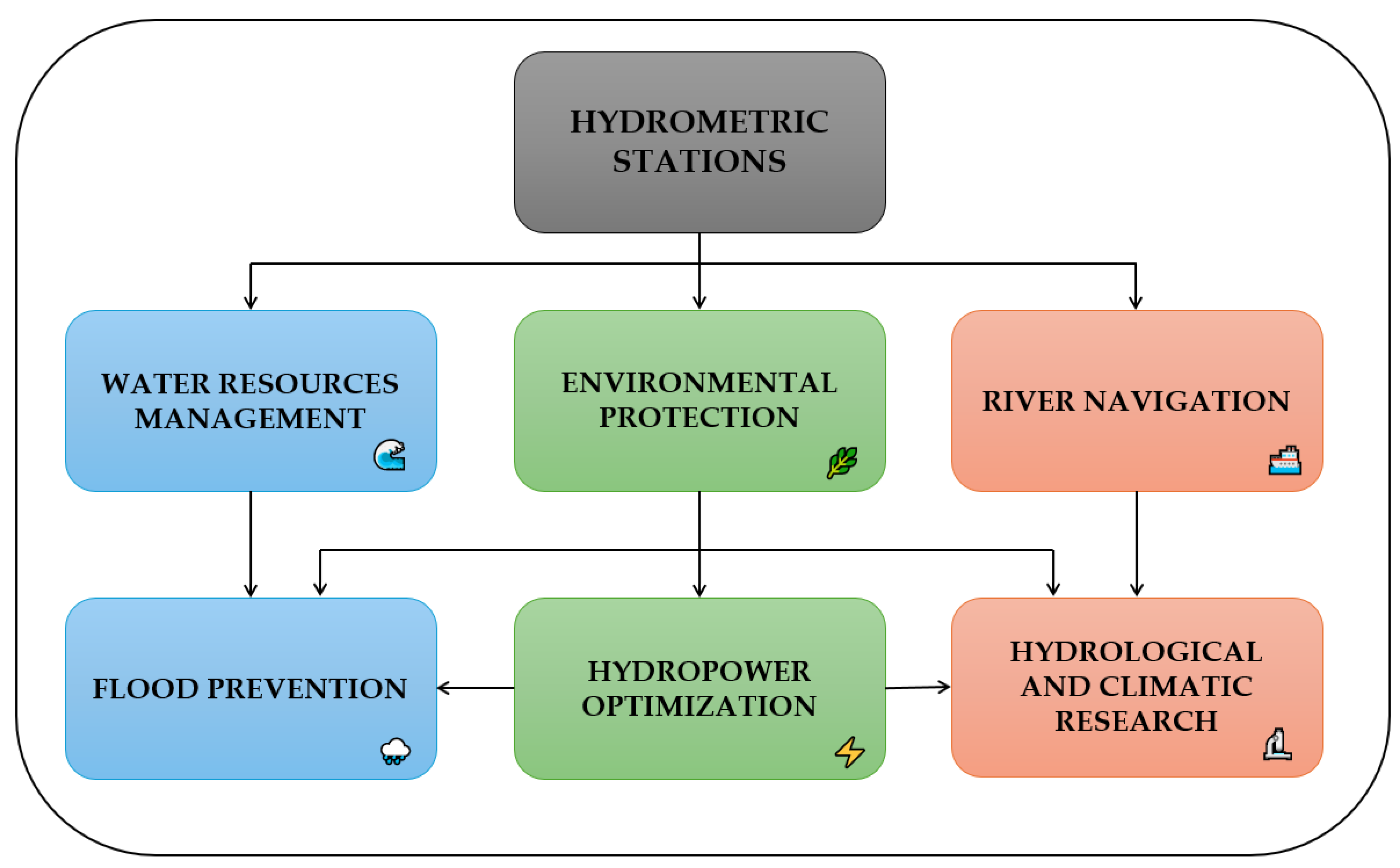
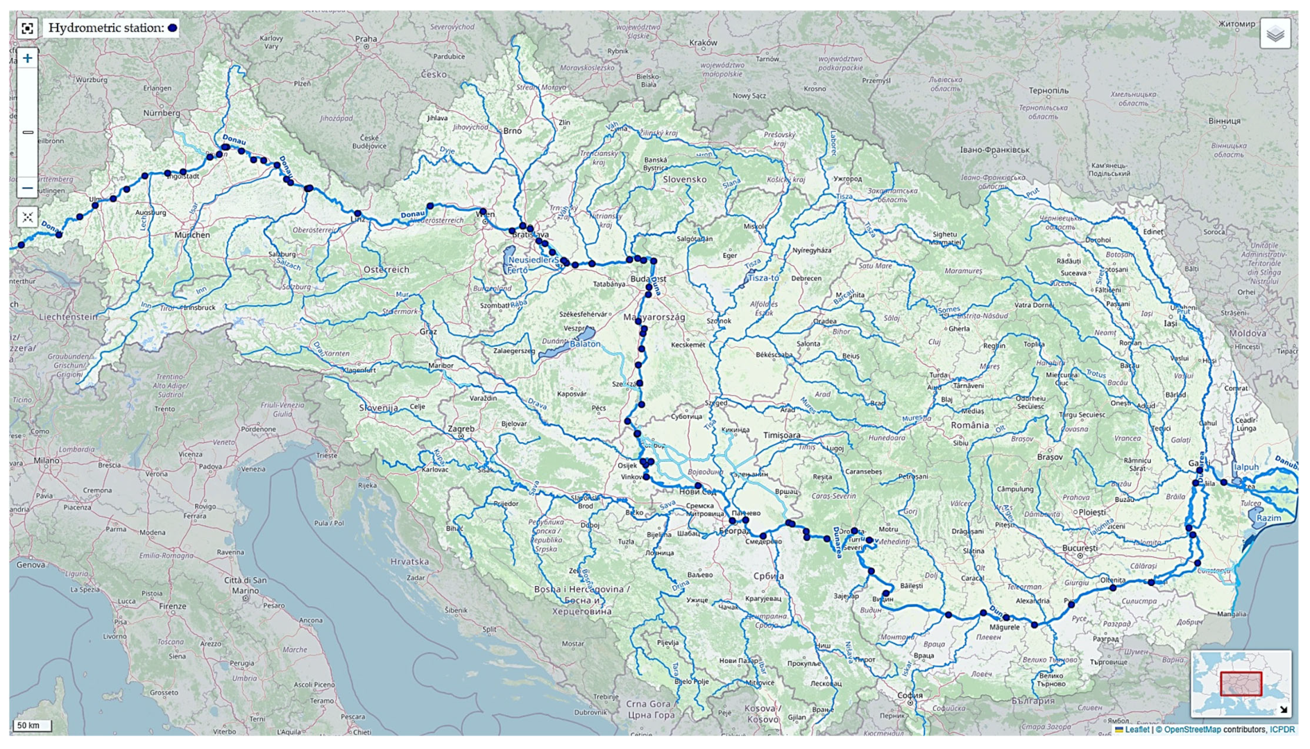
6.2. Hydrometric Station Network and Technologies

Due to the Danube’s economic benefits and to better prevent and manage risks [13], a network of hydrometric stations is located along the river’s entire course. These stations are strategically located and equipped with sensors and devices to measure water level, flow, temperature, water quality, and other essential parameters [139,140,141].
Figure 8 illustrates the importance of these stations. Water level and flow monitoring contribute to flood risk management and balanced management for irrigation and consumption. Concurrently, this monitoring guarantees the safety of river navigation and regulates water flows for energy production efficiency. Recorded data and parameters support the conservation of ecosystems and the monitoring of pollution impacts, and they can be used in studies on the evolution of the hydrological regime.
Hydrometric stations are essential for collecting data on water quantity and quality. These data are essential for the effective management of water resources, providing the basis for strategic planning for sustainable water use. In addition, environmental protection depends on such information, which is used to monitor pollution and conserve aquatic ecosystems. At the same time, river navigation requires the maintenance of optimal and safe water levels to facilitate traffic. Hydrological and climatic research using the data collected analyzes long-term trends, and thus, predictive models can be developed to support decision-making in these areas. Therefore, all these sectors are interlinked and depend on data from hydrometric stations for integrated and efficient management of water resources and associated risks.
Using DanubeHIS [142], the geospatial system of the International Commission for the Protection of the Danube River (ICPDR) [39], Figure 9 shows the hydrometric stations along the Danube, marked with blue circles. Table 10 presents the estimated number of stations, representative stations, main functions, types of equipment used, and network particularities for each country.
Depending on the section of the Danube, there are varying stations, which can be either manual or automatic, based on the local infrastructure and accessibility. If in mountainous regions (such as Germany) the station number is lower, but they are equipped with more accurate measuring devices for demanding conditions, the number of stations increases as the river reaches lower areas. High density of stations in urban and industrial regions protects the population and economic activities. The stations present in the Danube Delta region have a dual role, both for monitoring and environmental protection. International coordination is done by ICPDR [39], based on data exchange and joint forecasts.
In Germany, hydrometric stations are located upstream and are essential for monitoring the level and flow in the early phase of the river. Due to the characteristics of the mountainous area, they present non-contact hydrometric radars and hydrostatic pressure sensors. The collected data are used for hydrological modeling of the whole river. The hydrometric stations in Austria are located at strategic points such as Linz, Vienna, or Krems. They monitor water level and flow to control navigation, dams, and hydropower storage. In Slovakia, the stations located mainly in urban areas are fully automated, measuring flow and water level, and integrating meteorological data. Hungary has a dense network of modernized hydrometric monitoring, and the primary purpose is to prevent urban flooding and ensure navigability. In Croatia, these stations provide water level and flow monitoring and are essential for navigational safety, and the equipment is specific to river areas. Serbia has one of the most developed networks on the Danube, and the stations are essential for hydrological forecasting and flood management [143]. The network is dense and modern, and data is automatically transmitted to command centers for analysis and early warning. In Bulgaria, the stations are equipped with multi-parametric sensors and complex measurement equipment and are involved in the Danube’s navigation and ecological monitoring. Romania has the most extensive network of hydrometric stations on the Danube. These stations have modern equipment and transmit real-time water level, flow, and temperature data. Their role is crucial in flood prevention, navigation, and environmental monitoring [144]. The hydrometric stations in Ukraine are concentrated in the Danube Delta [145], in locations such as Izmail, Reni, and Vilkove, and play a crucial role in monitoring the hydrological regime and protecting ecosystems.
As shown in Table 10 and based on information from ICPDR [39], modern hydrometric stations on the Danube are equipped with various equipment to collect and record hydrological and meteorological data continuously. These are chosen according to the specificity of the river section, accessibility, purpose of the station (navigation, flooding, water quality), and level of automation. Table 11 shows the types of sensors encountered and their role.
The Danube hydrometric network relies on modern communication and analysis systems for the data collected to be useful in real time for operational decisions (flooding, navigation, warning). GSM/GPRS/4G transmission is the most widespread method of communication used by most countries, such as Romania, Hungary, Austria, and Serbia, providing a constant connection with national monitoring centers. In regions with weak or non-existent GSM signal, such as mountainous areas in Germany or the Danube Delta in Ukraine, VHF/UHF radio networks are used as alternative solutions. For critical stations located in remote areas or disaster contexts, satellite data is transmitted using systems such as Meteosat or EUMETSAT [146,147].
The various technologies used to monitor the Danube highlight its complex nature and require close collaboration between national institutions and European organizations. Cooperation plays a vital role in the rapid and efficient data exchange between riparian countries, facilitating accurate forecasts, better risk management, and sustainable protection of the river ecosystem.

7. Future Perspectives and Specific Recommendations

In the evolving context of climate change, which intensifies risks, hydrological studies on the Danube must evolve towards more advanced, precise, and integrated methods aligned with technological development. A SWOT (Strengths, Weaknesses, Opportunities, and Threats) analysis, presented in Table 12, has been carried out to outline the development potential of these methods and identify strategic directions for improvement. This highlights the current monitoring system’s strengths and weaknesses, as well as the opportunities and risks associated with future technological and institutional interventions.
The SWOT analysis highlights that while there is a strong institutional and technological basis for hydrological studies on the Danube, coordinated efforts are needed to overcome current weaknesses and to capitalize on emerging opportunities. Adapting to new climatic and technological conditions requires investment in physical monitoring infrastructure and analytical and digital capabilities. Thus, the following directions can be proposed:
  • The monitoring infrastructure should be improved by installing the latest generation of sensors in hydrometric stations to allow real-time data transmission.
  • Create an integrated transboundary open-access cross-border data platform to facilitate research, analysis, and rapid decision-making.
  • Promote applied research in artificial intelligence, remote sensing, and hydrological scenario simulation.
  • Foster collaboration between countries through participatory governance mechanisms involving central authorities and local communities.

8. Conclusions

The Danube is an international river basin with historical, economic, and political implications for the European continent. It provides a vital route for global trade through the Rhine-Main-Danube and Danube-Black Sea canals. This river’s economic importance impacts several branches of industry, the most important being transporting goods and passengers, followed by energy production and tourism.
The paper outlines the Danube River’s complex and multifunctional importance from a geographical, hydrological, economic, and institutional point of view. The Danube and its main tributaries have an extensive hydrographic network, essential for biodiversity, water supply, and the development of the crossed regions.
Navigation on the Danube is an essential component of the regional economy. It serves trade, transportation, and tourism. However, it is often disrupted by hydrological hazards such as floods, droughts, and changes in water flow. Cooperation between riparian states is essential to implement standard policies, protect water resources, and prevent pollution. Continued collaboration between these institutions will ensure a sustainable and resilient future for the Danube River and surrounding regions.
Hydrological studies are vital for the sustainable management of the Danube, the prevention of natural hazards, and the optimization of resource use. They highlight the Danube’s significant risks, such as floods and droughts that affect the environment and economic activities. Climate change and morphological alteration amplify such risks. Thus, modern monitoring approaches and predictive-statistical models play a key role in reducing the impact of extreme events.
Technological advances such as sensors, satellite remote sensing, and advanced simulation models have revolutionized hydrological studies on the Danube. These technologies allow data to be collected faster and more accurately, facilitating more accurate predictions and assessments of hydrological risks. In addition, applying artificial intelligence and machine learning algorithms in predictive models contributes to more efficient resource and risk management.
In conclusion, the Danube River is vital to the region it crosses. Protecting and managing responsibly requires international collaboration, advanced technology, and an integrated approach to support economic development and environmental protection.

Author Contributions

Conceptualization, V.-I.P. and. A.-M.C. methodology, analysis, and visualization, V.-I.P., A.-M.C. and E.R.; writing—original draft preparation, A.-M.C. and V.-I.P.; supervision and writing final version E.R. and M.A. All authors have read and agreed to the published version of the manuscript.

Funding

This research is part of the project “Innovative sediment management framework for a SUstainNable DANube black Sea system (SUNDANSE)”, co-funded by the European Union (Grant Agreement No. 101156533/2024).

Data Availability Statement

Not applicable.

Acknowledgments

This research is part of the project ‘Innovative sediment management framework for a SUstainNable DANube Black Sea system (SUNDANSE)’, co-funded by the European Union (Grant Agreement No. 101156533/2024). Views and opinions expressed are however those of the author(s) only and do not necessarily reflect those of the European Union or the European Climate, Infrastructure and Environment Executive Agency. Neither the European Union nor the granting authority can be held responsible for them.

Conflicts of Interest

The authors declare no conflicts of interest.

Abbreviations

The following abbreviations are used in this manuscript:
ADCP Acoustic Doppler Current Profiler
AIArtificial Intelligence
ArcGISArc Geographic Information System
DEFDanube Environmental Forum
DFRMPDanube Flood Risk Management Plan
DMCSEEDrought Management Centre for Southeastern Europe
DriDanubeDrought Risk in the Danube Region
DSTFDanube Sturgeon Task Force
DUSDanube Drought User Service
EDOEuropean Drought Observatory
EEAEuropean Environment Agency
EUEurope Union
EUMETSATEuropean Organisation for the Exploitation of Meteorological Satellites
EUSDREU Strategy for the Danube Region
GISGeographic Information System
GPRGround-Penetrating Radar
GPRSGeneral Packet Radio Service
GPRSIMGround Penetrating Radar Simulation Software
GRDCGlobal Runoff Data Centre
GSMGlobal System for Mobile Communications
HEC-HMSHydrologic Engineering Center—Hydrologic Modeling System
HEC-RAS Hydrologic Engineering Center—River Analysis System
HYPEHydrological Predictions for the Environment
ICPDRInternational Commission for the Protection of the Danube River
IoT sensorInternet of Things sensor
LiDARLight Detection and Ranging
LSTM Long Short-Term Memory
MODISModerate Resolution Imaging Spectroradiometer
NGOsNon-governmental organizations
pHPotential of hydrogen
RNARomanian Naval Authority
TRMMTropical Rainfall Measuring Mission
SWATThe Soil and Water Assessment Tool
SWOTStrengths, Weaknesses, Opportunities, and Threats
UHFUltra High Frequency
UNUnited Nations
UNESCOUnited Nations Educational, Scientific and Cultural Organization
VHFVery High Frequency
WMOWorld Meteorological Organization
4GFourth Generation of Mobile Network Technology

References

  1. Bowen, A.; Cochrane, S.; Fankhauser, S. Climate change, adaptation and economic growth. Clim. Change 2012, 113, 95–106. [Google Scholar] [CrossRef]
  2. Samuel, H.; Joel, S. Estimating global impacts from climate change. Glob. Environ. Change 2004, 14, 201–218. [Google Scholar] [CrossRef]
  3. Calzadilla, A.; Rehdanz, K.; Betts, R.; Falloon, P.; Wiltshire, A.; Tol, R.S.J. Climate change impacts on global agriculture. Clim. Change 2023, 120, 357–374. [Google Scholar] [CrossRef]
  4. Richard, S.J.; Thomas, E.D.; Onno, J.K.; Joel, B.S. Distributional aspects of climate change impacts. Glob. Environ. Change 2004, 14, 259–272. [Google Scholar] [CrossRef]
  5. Bibi, F.; Rahman, A. An Overview of Climate Change Impacts on Agriculture and Their Mitigation Strategies. Agriculture 2023, 13, 1508. [Google Scholar] [CrossRef]
  6. Balica, S.F.; Wright, N.G.; Van der Meulen, F. A flood vulnerability index for coastal cities and its use in assessing climate change impacts. Nat. Hazards 2012, 64, 73–105. [Google Scholar] [CrossRef]
  7. Dey, R.; Lewis, S.C. Chapter 6—Natural disasters linked to climate change. In The Impacts of Climate Change; Letcher, T.M., Ed.; Elsevier: Amsterdam, The Netherlands, 2021; pp. 177–193. [Google Scholar] [CrossRef]
  8. Brázdil, R.; Kundzewicz, Z.W.; Benito, G.; Demarée, G.; Macdonald, N.; Roald, L.A. Historical floods in Europe in the past millennium. In Changes in Flood Risk in Europe; Kundzewicz, Z.W., Ed.; IAHS Special Publication; IAHS Press: Wallingford, UK, 2012; Volume 10, pp. 121–166. [Google Scholar] [CrossRef]
  9. Chiroşca, A.-M.; Rusu, L. Study on Navigation Conditions and Shipping Traffic on the Danube in the Period 2010–2020. J. Danub. Stud. Res. 2021, 11, 192–201. [Google Scholar]
  10. Stagl, J.C.; Hattermann, F.F. Impacts of Climate Change on Riverine Ecosystems: Alterations of Ecologically Relevant Flow Dynamics in the Danube River and Its Major Tributaries. Water 2016, 8, 566. [Google Scholar] [CrossRef]
  11. Kling, H.; Fuchs, M.; Paulin, M. Runoff conditions in the upper Danube basin under an ensemble of climate change scenarios. J. Hydrol. 2012, 424–425, 264–277. [Google Scholar] [CrossRef]
  12. Stanzel, P.; Kling, H. From ENSEMBLES to CORDEX: Evolving climate change projections for Upper Danube River flow. J. Hydrol. 2018, 563, 987–999. [Google Scholar] [CrossRef]
  13. Mikhailova, M.V.; Mikhailov, V.N.; Morozov, V.N. Extreme hydrological events in the Danube River basin over the last decades. Water Resour. 2012, 39, 161–179. [Google Scholar] [CrossRef]
  14. Sommerwerk, N.; Bloesch, J.; Baumgartner, C.; Bittl, T.; Čerba, D.; Csányi, B.; Davideanu, G.; Dokulil, M.; Frank, G.; Grecu, I. Chapter 3—The Danube River Basin. In Rivers of Europe, 2nd ed.; Tockner, K., Zarfl, C., Robinson, C.T., Eds.; Elsevier: Amsterdam, The Netherlands, 2022; pp. 81–180. [Google Scholar] [CrossRef]
  15. Ebert, S.; Hulea, O.; Strobel, D. Floodplain restoration along the lower Danube: A climate change adaptation case study. Clim. Dev. 2009, 1, 212–219. [Google Scholar] [CrossRef]
  16. Arseni, M.; Rosu, A.; Calmuc, M.; Calmuc, V.A.; Iticescu, C.; Georgescu, L.P. Development of Flood Risk and Hazard Maps for the Lower Course of the Siret River, Romania. Sustainability 2020, 12, 6588. [Google Scholar] [CrossRef]
  17. Georgescu, L.P.; Ionescu, R.V.; Antohi, V.M.; Zlati, M.L.; Iticescu, C. A New Model for Quantifying the Impact of the Social Economy on the Sustainability of Water Resources. Water 2025, 17, 561. [Google Scholar] [CrossRef]
  18. Grigorescu, L. The Strategic Importance of the Danube in the Context of a Future Romanian Maritime Security Strategy for the Black Sea. Rom. Mil. Think. 2023, 2, 96–115. Available online: https://www.ceeol.com/search/article-detail?id=1211151 (accessed on 17 February 2025). [CrossRef]
  19. Chirosca, A.M.; Vazdoaga, I.; Popa, V.I.; Rusu, L. The economic importance of navigation along the Danube-Black Sea channel. Int. Multidiscip. Sci. GeoConference SGEM 2021, 21, 297–305. [Google Scholar] [CrossRef]
  20. Gasparotti, C.; Modiga, A.; Domnisoru, L.; Rusu, E. The recent dynamics of the navigation and main harbour operations in the area of the maritime Danube. In Proceedings of the International Conference on Traffic and Transport Engineering, Belgrade, Serbia, 24–25 November 2016; pp. 242–249. [Google Scholar]
  21. Jászberényi, M.; Miskolczi, M. Danube cruise tourism as a niche product—An overview of the current supply and potential. Sustainability 2020, 12, 4598. [Google Scholar] [CrossRef]
  22. Lukić, D.; Berjan, S.; El Bilali, H. Indicators of tourism development of the Serbian Danube region. R-Economy 2018, 4, 30–37. [Google Scholar] [CrossRef]
  23. Chiripuci, B.-C.; Constantin, M.; Popescu, M.-F.; Scrieciu, A. The Socio-Economic Impact of Migration on the Labor Market in the Romanian Danube Region. Sustainability 2020, 12, 8654. [Google Scholar] [CrossRef]
  24. Bănăduc, D.; Rey, S.; Trichkova, T.; Lenhardt, M.; Curtean-Bănăduc, A. The Lower Danube River–Danube Delta–North West Black Sea: A pivotal area of major interest for the past, present and future of its fish fauna—A short review. Sci. Total Environ. 2016, 545, 137–151. [Google Scholar] [CrossRef]
  25. Dogaru, D.; Mauser, W.; Balteanu, D.; Krimly, T.; Lippert, C.; Sima, M.; Frank, A. Irrigation water use in the Danube Basin: Facts, governance and approach to sustainability. J. Environ. Geogr. 2019, 12, 1–12. [Google Scholar] [CrossRef]
  26. Jeločnik, M.; Nastić, L.; Subić, J. Analysis of agriculture and rural development in the upper Danube region-SWOT analysis. In Proceedings of the International Scientific Meeting-Economie Agrara si Dezvoltare Rurala Realitati si Perspective Pentru Romania, Editia a–II–a, Plenary Session. Bucharest, Romania, 8–9 September 2011; pp. 9–15. Available online: https://symposium.iceadr.ro/wp-content/uploads/2023/04/Volum-2011.pdf (accessed on 17 February 2025).
  27. Smederevac-Lalić, M.; Jarić, I.; Višnjić-Jeftić, Ž.; Skorić, S.; Cvijanović, G.; Gačić, Z.; Lenhardt, M. Management approaches and aquaculture of sturgeons in the Lower Danube region countries. J. Appl. Ichthyol. 2011, 27, 94–100. [Google Scholar] [CrossRef]
  28. Draganova-Zlateva, I.; Kolev, V.; Dilkov, P. Hydro Energy Use of the Water Potential of The Danube River. In Proceedings of the 14th Electrical Engineering Faculty Conference (BulEF), Varna, Bulgaria, 14–17 September 2022; pp. 1–5. [Google Scholar]
  29. Huđek, H.; Žganec, K.; Pusch, M.T. A review of hydropower dams in Southeast Europe–distribution, trends and availability of monitoring data using the example of a multinational Danube catchment subarea. Renew. Sustain. Energy Rev. 2020, 117, 109434. [Google Scholar] [CrossRef]
  30. Wagner, B.; Hauer, C.; Habersack, H. Current hydropower developments in Europe. Curr. Opin. Environ. Sustain. 2019, 37, 41–49. [Google Scholar] [CrossRef]
  31. Năstase, G.; Şerban, A.; Năstase, A.F.; Dragomir, G.; Brezeanu, A.I.; Iordan, N.F. Hydropower development in Romania. A review from its beginnings to the present. Renew. Sustain. Energy Rev. 2017, 80, 297–312. [Google Scholar] [CrossRef]
  32. Szépszó, G.; Lingemann, I.; Klein, B.; Kovács, M. Impact of climate change on hydrological conditions of Rhine and Upper Danube rivers based on the results of regional climate and hydrological models. Nat. Hazards 2014, 72, 241–262. [Google Scholar] [CrossRef]
  33. Răileanu, A.B.; Rusu, L.; Rusu, E. An Evaluation of the Dynamics of Some Meteorological and Hydrological Processes along the Lower Danube. Sustainability 2023, 15, 6087. [Google Scholar] [CrossRef]
  34. Popa, P.; Murariu, G.; Timofti, M.; Georgescu, L. Multivariate Statistical Analyses of water quality of Danube River at Galati, Romania. Environ. Eng. Manag. J. 2018, 17, 1249–1266. Available online: http://www.eemj.icpm.tuiasi.ro/pdfs/vol17/full/no5/24_290_Popa_14.pdf (accessed on 17 February 2025).
  35. Radmilović, Z.; Maraš, V. Role of Danube inland navigation in Europe. Int. J. Traffic Transp. Eng. 2011, 1, 28–40. [Google Scholar]
  36. Chirosca, A.M.; Rusu, L.; Popa, V.I.; Rusu, E. Climate analysis along the navigation routes on the Danube. Int. Multidiscip. Sci. GeoConference SGEM 2024, 3.1, 59–66. [Google Scholar] [CrossRef]
  37. Berlinsky, N.; Bogatova, Y.; Garkavaya, G. Estuary of the Danube. In Estuaries; Wangersky, P.J., Ed.; The Handbook of Environmental Chemistry; Springer: Berlin/Heidelberg, Germany, 2006; Volume 5H, pp. 233–264. [Google Scholar] [CrossRef]
  38. Vâzdoagă, I.; Chiroşcă, A.M.; Popa, V.I.; Rusu, L. Extreme phenomena on Danube hydrodynamics and the influence on the navigation conditions. Int. Multidiscip. Sci. GeoConference SGEM 2020, 3.1, 123–130. [Google Scholar] [CrossRef]
  39. The International Commission for the Protection of the Danube River (ICPDR). Available online: https://www.icpdr.org/danube-basin/danube-river-basin/ (accessed on 24 May 2025).
  40. Giosan, L.; Donnelly, J.; Vespremeanu, E.; Bhattacharya, J.; Olariu, C.; Buonaiuto, F. River delta morphodynamics: Examples from the Danube Delta. River Deltas Concepts Model Ex. SEPM Spec. Publ. 2005, 83, 393–411. [Google Scholar]
  41. Tănăsescu, M.; Constantinescu, S. The human ecology of the Danube Delta: A historical and cartographic perspective. J. Environ. Manag. 2020, 262, 110324. [Google Scholar] [CrossRef] [PubMed]
  42. Stagl, J.C.; Hattermann, F.F. Impacts of Climate Change on the Hydrological Regime of the Danube River and Its Tributaries Using an Ensemble of Climate Scenarios. Water 2015, 7, 6139–6172. [Google Scholar] [CrossRef]
  43. Ogrinc, N.; Markovics, R.; Kanduč, T.; Walter, L.M.; Hamilton, S.K. Sources and transport of carbon and nitrogen in the River Sava watershed, a major tributary of the River Danube. Appl. Geochem. 2008, 23, 3685–3698. [Google Scholar] [CrossRef]
  44. Schreiber, H.; Behrendt, H.; Constantinescu, L.T.; Cvitanic, I.; Drumea, D.; Jabucar, D.; Zessner, M. Nutrient emissions from diffuse and point sources into the River Danube and its main tributaries for the period of 1998–2000–results and problems. Water Sci. Technol. 2005, 51, 283–290. [Google Scholar] [CrossRef]
  45. Petošić, D.; Mustać, I.; Filipović, V.; Stričević, I. Joint impact of the Danube-Sava canal and agriculture upon the existing agroecosystems. In Proceedings of the 46th Croatian and 6th International Symposium on Agriculture, Opatija, Croatia, 14–18 February 2011; pp. 41–50. [Google Scholar]
  46. Milanović, A.; Milijašević, D.; Brankov, J. Assessment of polluting effects and surface water quality using water pollution index: A case study of Hydro-system Danube-Tisa-Danube, Serbia. Carpathian J. Earth Environ. Sci. 2011, 6, 269–277. [Google Scholar]
  47. Grabić, J.; Benka, P.; Bezdan, A.; Josimov-Dunđerski, J.; Salvai, A. Water quality management for preserving fish populations within hydro-system Danube-Tisa-Danube, Serbia. Carpathian J. Earth Environ. Sci. 2016, 11, 235–243. [Google Scholar]
  48. Garnier, J.; Billen, G.; Hannon, E.; Fonbonne, S.; Videnina, Y.; Soulie, M. Modelling the Transfer and Retention of Nutrients in the Drainage Network of the Danube River. Estuar. Coast. Shelf Sci. 2002, 54, 285–308. [Google Scholar] [CrossRef]
  49. Ionuş, O.; Licurici, M.; Pătroescu, M.; Boengiu, S. Assessment of flood-prone stripes within the Danube drainage area in the South-West Oltenia Development Region, Romania. Nat. Hazards 2015, 75 (Suppl. S1), 69–88. [Google Scholar] [CrossRef]
  50. Backalic, T.; Maslaric, M. Navigation conditions and the risk management in inland waterway transport on the middle Danube. Transp. Probl. 2012, 7, 13–24. [Google Scholar]
  51. Pencheva, V.; Asenov, A.; Sładkowski, A.; Georgiev, I.; Beloev, I.; Ivanov, K. The Danube River, Multimodality and Intermodality. In Modelling of the Interaction of the Different Vehicles and Various Transport Modes; Sładkowski, A., Ed.; Lecture Notes in Intelligent Transportation and Infrastructure; Springer: Cham, Switzerland, 2020; pp. 233–288. [Google Scholar] [CrossRef]
  52. Turnock, D. The Danube-Black Sea Canal and its impact on Southern Romania. GeoJournal 1986, 12, 65–79. [Google Scholar] [CrossRef]
  53. Šołkic, S.; Đekic, Z.; Kresojevic, M. Analysis of River–Sea Transport in the Direction of the Danube–Black Sea and the Danube Rhine River River Main. In Marine Navigation and Safety of Sea Transportation: Navigational Problems; CRC Press: Boca Raton, FL, USA, 2013; pp. 199–207. [Google Scholar]
  54. Chirosca, A.M.; Rusu, L. Statistical and economic analysis of the Rhine-Main-Danube Canal, the bridge between the North Sea and the Black Sea. J. Danub. Stud. Res. 2021, 11, 192–201. [Google Scholar]
  55. Mako, P.; Galieriková, A. Inland navigation on the Danube and the Rhine waterways. Transp. Res. Procedia 2021, 55, 10–17. [Google Scholar] [CrossRef]
  56. Dávid, A.; Midan, A.A.; Klosak, M.; Douimia, Y. Sustainability of Inland Water Transport on the Rhine-Main-Danube Waterway. In Proceedings of the 3rd Cognitive Mobility Conference. COGMOB 2024; Zöldy, M., Ed.; Lecture Notes in Networks and Systems; Springer: Cham, Switzerland, 2025; Volume 1258. [Google Scholar] [CrossRef]
  57. Olson, K.R.; Krug, E. The Danube, an Empire boundary river: Settlements, invasions, navigation, and trade pathway. J. Water Resour. Prot. 2020, 12, 884–897. [Google Scholar] [CrossRef]
  58. Pfaff, W. European Transport Policy and Role of the Danube River. Transp. Res. Rec. 2005, 1909, 70–73. [Google Scholar] [CrossRef]
  59. Baltălungă, A.A.; Dumitrescu, D. The role of the Danube River as the main waterway of central and south eastern Europe. Geopolitical and economic aspects. Rom. Rev. Political Geogr. 2008, 1, 57–66. [Google Scholar]
  60. Katona, C.; Toma, A. The cargo evolution transportation on romanian waterways Cernavoda-Agigea and Poarta Alba-Midia Navodari. Sci. Bull. Mircea Cel Batran Nav. Acad. 2015, 18, 49. [Google Scholar]
  61. Doğan, T. An Analysis of the Pan-European Transport Network. Master’s Thesis, Middle East Technical University, Ankara, Turkey, 2005; p. 31661568. [Google Scholar]
  62. Tsonkov, N.; Petrov, K. Possibilities for the construction of a parallel route of the European transport corridor No 9 through Romania, Bulgaria, and Greece. IOP Conf. Ser. Mater. Sci. Eng. 2023, 1297, 012018. [Google Scholar] [CrossRef]
  63. Roche, K.F.; Janač, M.; Jurajda, P. A review of Gobiid expansion along the Danube-Rhine corridor–geopolitical change as a driver for invasion. Knowl. Manag. Aquat. Ecosyst. 2013, 411, 23. [Google Scholar] [CrossRef]
  64. Zăinescu, F.I.; Tătui, F.; Valchev, N.N.; Vespremeanu-Stroe, A. Storm climate on the Danube delta coast: Evidence of recent storminess change and links with large-scale teleconnection patterns. Nat. Hazards 2017, 87, 599–621. [Google Scholar] [CrossRef]
  65. Răileanu, A.B.; Rusu, L.; Marcu, A.; Rusu, E. The Expected Dynamics for the Extreme Wind and Wave Conditions at the Mouths of the Danube River in Connection with the Navigation Hazards. Inventions 2024, 9, 41. [Google Scholar] [CrossRef]
  66. Hattermann, F.F.; Wortmann, M.; Liersch, S.; Toumi, R.; Sparks, N.; Genillard, C.; Schröter, K.; Steinhausen, M.; Gyalai-Korpos, M.; Máté, K.; et al. Simulation of flood hazard and risk in the Danube basin with the Future Danube Model. Clim. Serv. 2018, 12, 14–26. [Google Scholar] [CrossRef]
  67. Dan, S.; Stive, M.J.; Walstra, D.J.R.; Panin, N. Wave climate, coastal sediment budget and shoreline changes for the Danube Delta. Mar. Geol. 2009, 262, 39–49. [Google Scholar] [CrossRef]
  68. Schiller, H.; Miklós, D.; Sass, J. The Danube River and its Basin Physical Characteristics, Water Regime and Water Balance. In Hydrological Processes of the Danube River Basin; Brilly, M., Ed.; Springer: Dordrecht, The Netherlands, 2010; pp. 25–77. [Google Scholar] [CrossRef]
  69. Lóczy, D. The Danube: Morphology, evolution, and environmental issues. Large Rivers Geomorphol. Manag. 2022, 2, 335–367. [Google Scholar] [CrossRef]
  70. Danube Commissioning. Available online: https://www.danubecommission.org/ (accessed on 15 February 2025).
  71. Romanian Naval Authority. Available online: https://portal.rna.ro/ (accessed on 17 February 2025).
  72. EU Strategy for the Danube Region. Available online: https://ec.europa.eu/regional_policy/policy/cooperation/macro-regional-strategies/danube_en (accessed on 17 February 2025).
  73. Special Navigation Rules for the Danube Sector Between Sulina Roadstead and Braila Harbour (km 175). Available online: https://www.afdj.ro/ro/content/reguli-speciale-de-navigatie-pe-sectorul-dunarii-cuprins-intre-rada-sulina-si-portul-braila (accessed on 20 February 2025).
  74. Danube Water Level. Galati Lower Danube River Administration. Available online: https://www.afdj.ro/en/content/danube-water-level (accessed on 20 February 2025).
  75. Czakó, K.; Fekete, D.; Poreisz, V. Economic differences of countries by the River Danube. Procedia Econ. Financ. 2014, 9, 163–175. [Google Scholar] [CrossRef]
  76. Bărbulescu, M.; Hagiu, A.; Bâldan, C. The Evolution of Inflation at the Level of the Danube Region Countries. J. Danub. Stud. Res. 2024, 14, 23–35. [Google Scholar]
  77. Dokov, H.; Stamenkov, I. Measuring the Complex Socio-economic Development of the Danube-adjacent NUTS2 Regions. Forum Geogr. 2017, 16, 152–162. [Google Scholar] [CrossRef]
  78. Dávid, A.; Madudová, E. The Danube river and its importance on the Danube countries in cargo transport. Transp. Res. Procedia 2019, 40, 1010–1016. [Google Scholar] [CrossRef]
  79. Kovačević, I.; Bradić-Martinović, A.; Petković, G. Covid-19 impact on cultural and natural Pan-European thematic routes. Ekon. Preduzeća 2021, 69, 357–368. [Google Scholar] [CrossRef]
  80. Ionescu, R.V. The Need for a Danube Post-Covid 19 Strategy for Economic Survival. J. Danub. Stud. Res. 2020, 10, 34–50. [Google Scholar]
  81. Dávid, A.; Blaško, S.; Ficzere, P. The impact of the war in Ukraine on inland water transport in the Danube region. Transp. Res. Procedia 2023, 74, 188–193. [Google Scholar] [CrossRef]
  82. Nae, A.; Ungureanu, M.R. The Strategic Importance of the Danube and the Lower Danube Region in the Context of the War in Ukraine. Der Donauraum 2024, 64, 37–48. [Google Scholar]
  83. Alecse, C.; Şerban, P.S.; Safta, C.A. Russo-Ukrainian war influence on the Danube-Black Sea Channel traffic. Sci. Bull. Mircea Cel. Batran Nav. Acad. 2023, 26, 171–177. [Google Scholar]
  84. Horoshkova, L.; Horoshkov, S.; Korniichuk, Y. The development of Danube Ports amid war and post-war recovery of Ukraine. Man and Environment. Issues Neoecology 2024, 41, 70–82. [Google Scholar] [CrossRef]
  85. Mako, P.; Dávid, A.; Böhm, P.; Savu, S. Sustainable transport in the Danube region. Sustainability 2021, 13, 6797. [Google Scholar] [CrossRef]
  86. Dávid, A.; Gašparík, J.; Galieriková, A. The Danube ports as multimodal transport hubs and their logistics services. Bus. Logist. Mod. Manag. 2019, 19, 353–365. [Google Scholar]
  87. Bojić, S.; Georgijević, M.; Brcanov, D. Transformation of the Danube ports into logistics centers and their integration in the EU logistics network. Towards Innov. Freight. Logist. 2016, 2, 217–229. [Google Scholar] [CrossRef]
  88. Ionita, M.; Badaluta, C.A.; Scholz, P.; Chelcea, S. Vanishing river ice cover in the lower part of the Danube basin—Signs of a changing climate. Sci. Rep. 2018, 8, 7948. [Google Scholar] [CrossRef]
  89. Stančíková, A. Thermal and Ice Regimes of the Danube River and Its Tributaries. In Hydrological Processes of the Danube River Basin; Brilly, M., Ed.; Springer: Dordrecht, The Netherlands, 2010; pp. 259–291. [Google Scholar] [CrossRef]
  90. Takács, K.; Kern, Z.; Pásztor, L. Long-term ice phenology records from eastern–central Europe. Earth Syst. Sci. Data 2018, 10, 391–404. [Google Scholar] [CrossRef]
  91. Năvodaru, I.; Staras, M.; Buijse, A.D.; De Leew, J.J. Changes in fish population in Danube delta lakes: Effects of hydrology and water quality change. Review of results and potential for rehabilitation. Ecohydrol. Hydrobiol. 2005, 5, 245–256. [Google Scholar]
  92. Panin, N.; Jipa, D. Danube River sediment input and its interaction with the north-western Black Sea. Estuar. Coast. Shelf Sci. 2002, 54, 551–562. [Google Scholar] [CrossRef]
  93. European Environment Agency. Available online: https://www.eea.europa.eu/en (accessed on 3 March 2025).
  94. Romanescu, G.; Constantin, C.S. Anthropogenic interventions and hydrological-risk phenomena in the fluvial-maritime delta of the Danube (Romania). Ocean. Coast. Manag. 2014, 102, 123–130. [Google Scholar] [CrossRef]
  95. Banescu, A.; Arseni, M.; Georgescu, L.P.; Rusu, E.; Iticescu, C. Evaluation of Different Simulation Methods for Analyzing Flood Scenarios in the Danube Delta. Appl. Sci. 2020, 10, 8327. [Google Scholar] [CrossRef]
  96. Herget, J.; Kapala, A.; Krell, M.; Rustemeier, E.; Simmer, C.; Wyss, A. The millennium flood of July 1342 revisited. Catena 2015, 130, 82–94. [Google Scholar] [CrossRef]
  97. Floods. ICPDR—International Commission for the Protection of the Danube River. Available online: https://www.icpdr.org/tasks-topics/topics/floods (accessed on 24 February 2025).
  98. Mikhailov, V.N.; Morozov, V.N.; Cheroy, N.I.; Mikhailova, M.V.; Zav’Yalova, Y.F. Extreme flood on the Danube River in 2006. Russ. Meteorol. Hydrol. 2008, 33, 48–54. [Google Scholar] [CrossRef]
  99. Blöschl, G.; Nester, T.; Komma, J.; Parajka, J.; Perdigão, R.A.P. The June 2013 flood in the Upper Danube Basin, and comparisons with the 2002, 1954, and 1899 floods. Hydrol. Earth Syst. Sci. 2013, 17, 5197–5212. [Google Scholar] [CrossRef]
  100. Mitková, V.B.; Pekárová, P.; Miklánek, P.; Pekár, J. Hydrological simulation of flood transformations in the upper Danube River: Case study of large flood events. J. Hydrol. Hydromech. 2016, 4, 337–348. [Google Scholar] [CrossRef]
  101. Gren, M.; Groth, K.H.; Sylvén, M. Economic values of Danube floodplains. J. Environ. Manag. 1995, 45, 333–345. [Google Scholar] [CrossRef]
  102. Hein, T.; Schwarz, U.; Habersack, H.; Nichersu, I.; Preiner, S.; Willby, N.; Weigelhofer, G. Current status and restoration options for floodplains along the Danube River. Sci. Total Environ. 2016, 543, 778–790. [Google Scholar] [CrossRef]
  103. DanubeGIS. Available online: https://www.danubegis.org/maps (accessed on 4 June 2025).
  104. Danube Flood Risk Management Plan (DFRMP). Available online: https://www.icpdr.org/tasks-topics/tasks/flood-risk-management/danube-flood-risk-management-plan-2021 (accessed on 4 June 2025).
  105. Habersack, H.; Hein, T.; Stanica, A.; Liska, I.; Mair, R.; Jäger, E.; Hauer, C.; Bradley, C. Challenges of river basin management: Current status of, and prospects for, the River Danube from a river engineering perspective. Sci. Total Environ. 2016, 543, 828–845. [Google Scholar] [CrossRef] [PubMed]
  106. WWF Danube-Carpathians Program. Available online: https://wwf.panda.org/ (accessed on 3 March 2025).
  107. Joint Danube Survey. Available online: https://www.danubesurvey.org/ (accessed on 3 March 2025).
  108. Sušnik, A.; Gregoriĉ, G.; Szalai, S.; Boka, L.S.; Srđević, Z. Making drought management in the Danube region efficient and operative: Drought risk in the Danube region project (DriDanube). Vodoprivreda 2018, 50, 294–296. 349–354. [Google Scholar]
  109. Blauhut, V.; Stoelzle, M.; Ahopelto, L.; Brunner, M.I.; Teutschbein, C.; Wendt, D.E.; Akstinas, V.; Bakke, S.J.; Barker, L.J.; Bartošová, L.; et al. Lessons from the 2018–2019 European droughts: A collective need for unifying drought risk management. Nat. Hazards Earth Syst. Sci. 2022, 22, 2201–2217. [Google Scholar] [CrossRef]
  110. Knutzen, F.; Averbeck, P.; Barrasso, C.; Bouwer, L.M.; Gardiner, B.; Grünzweig, J.M.; Hänel, S.; Haustein, K.; Johannessen, M.R.; Kollet, S. Impacts and damages of the European multi-year drought and heat event 2018–2022 on forests, a review. EGUsphere 2023. [Google Scholar] [CrossRef]
  111. DriDanube. Drought Risk in the Danube Region. Available online: https://dtp.interreg-danube.eu/approved-projects/dridanube (accessed on 3 March 2025).
  112. Bucur, A.; Gregorič, G.; Grlj, A.; Kokalj, Ž.; Sušnik, A. Tool for Drought Monitoring in the Danube Region: Methods and Preliminary Developments. J. Environ. Geogr. 2018, 11, 67–75. [Google Scholar] [CrossRef]
  113. European Drought Observatory (EDO). Available online: https://drought.emergency.copernicus.eu/tumbo/edo/map/ (accessed on 3 March 2025).
  114. Drought Management Centre for Southeastern Europe (DMCSEE). Available online: https://www.droughtmanagement.info/support_base_partner/the-drought-management-centre-for-southeastern-europe/ (accessed on 3 March 2025).
  115. AQUEDUCT—Water Risk Atlas. Available online: https://www.wri.org/aqueduct (accessed on 4 June 2025).
  116. Danube Region (EUSDR). Available online: https://danube-region.eu/ (accessed on 10 March 2025).
  117. Drought User Service with Manual. Available online: https://dtp.interreg-danube.eu/uploads/media/approved_project_output/0001/38/6fe1d713f1aa39f1051878b9e3c72820763e2997.pdf (accessed on 10 March 2025).
  118. Global Runoff Data Centre. Available online: https://grdc.bafg.de/ (accessed on 10 March 2025).
  119. International Sava River Basin Commission. Available online: https://www.savacommission.org/ (accessed on 10 March 2025).
  120. Danube Sturgeon Task Force. Available online: https://dstf.info/ (accessed on 10 March 2025).
  121. Grancharova, E.; Tadjer, J. HEC-RAS simulation and physical modeling of the Danube River. In Proceedings of the International Symposium, ISB-INMA TEH′, Agricultural and Mechanical Engineering, Bucharest, Romania, 29 October 2021; pp. 122–129. [Google Scholar]
  122. Malagó, A.; Bouraoui, F.; Vigiak, O.; Grizzetti, B.; Pastori, M. Modelling water and nutrient fluxes in the Danube River Basin with SWAT. Sci. Total Environ. 2017, 603, 196–218. [Google Scholar] [CrossRef]
  123. Abbaspour, K.C.; Rouholahnejad, E.; Vaghefi, S.; Srinivasan, R.; Yang, H.; Kløve, B. A continental-scale hydrology and water quality model for Europe: Calibration and uncertainty of a high-resolution large-scale SWAT model. J. Hydrol. 2015, 524, 733–752. [Google Scholar] [CrossRef]
  124. Barthel, R.; Reichenau, T.G.; Krimly, T.; Dabbert, S.; Schneider, K.; Mauser, W. Integrated Modeling of Global Change Impacts on Agriculture and Groundwater Resources. Water Resour. Manag. 2012, 26, 1929–1951. [Google Scholar] [CrossRef]
  125. MIKE SHE. Available online: https://www.dhigroup.com/technologies/mikepoweredbydhi/mike-she (accessed on 4 June 2025).
  126. LISFLOOD Hydrological Model. Available online: https://web.jrc.ec.europa.eu/policy-model-inventory/explore/models/model-lisflood/ (accessed on 4 June 2025).
  127. Van Der Knijff, J.M.; Younis, J.; De Roo, A.P.J. LISFLOOD: A GIS-based distributed model for river basin scale water balance and flood simulation. Int. J. Geogr. Inf. Sci. 2008, 24, 189–212. [Google Scholar] [CrossRef]
  128. About the HYPE Model. Available online: https://hypeweb.smhi.se/about-us/about-the-model/ (accessed on 4 June 2025).
  129. Donnelly, C.; Andersson, J.C.M.; Arheimer, B. Using flow signatures and catchment similarities to evaluate the E-HYPE multi-basin model across Europe. Hydrol. Sci. J. 2015, 61, 255–273. [Google Scholar] [CrossRef]
  130. GLOWA-Danube. Available online: https://www.glowa-danube.de/eng/home/home.php (accessed on 4 June 2025).
  131. MIKE HYDRO Basin. Available online: https://www.dhigroup.com/technologies/mikepoweredbydhi/mike-hydro-basin (accessed on 4 June 2025).
  132. Popescu, I.; Cioaca, E.; Pan, Q.; Jonoski, A.; Hanganu, J. Use of hydrodynamic models for the management of the Danube Delta wetlands: The case study of Sontea-Fortuna ecosystem. Environ. Sci. Policy 2015, 46, 48–56. [Google Scholar] [CrossRef]
  133. Zăinescu, F.; Storms, J.E.; Vespremeanu-Stroe, A.; Van Der Vegt, H.; Schuster, M.; Anthony, E. Wave-influenced delta morphodynamics, long-term sediment bypass and trapping controlled by relative magnitudes of riverine and wave-driven sediment transport. Geophys. Res. Lett. 2024, 51, e2024GL111069. [Google Scholar] [CrossRef]
  134. Bratanov, D.; Vitliemov., P. Danube River Monitoring, Information and Advising System for Pollution Prevention and Control. In Proceedings of the 4th International Conference on Communications, Information, Electronic and Energy Systems (CIEES), Plovdiv, Bulgaria, 23–25 November 2023; pp. 1–4. [Google Scholar] [CrossRef]
  135. Iticescu, C.; Georgescu, L.P.; Topa, C.; Murariu, G. Monitoring the Danube Water Quality Near the Galati City. J. Environ. Prot. Ecol. 2014, 15, 30–38. [Google Scholar]
  136. Lukac, M.; Holubová, K. Numerical modelling of the Danube River channel morphological development at the Slovak Hungarian river section. In River Sedimentation; CRC Press: Boca Raton, FL, USA, 2016; pp. 682–689. [Google Scholar]
  137. Visescu, M.; Beilicci, E.; Beilicci, R. Sediment transport modelling with advanced hydroinformatic tool case study-modelling on Bega channel sector. Procedia Eng. 2016, 161, 1715–1721. [Google Scholar] [CrossRef]
  138. Arseni, M.; Roman, O.; Calmuc, M.; Calmuc, V.-A.; Rosu, A.; Petrea, S.-M.; Iticescu, C.; Georgescu, L.-P. An automated method for forestry determination using a UAV LiDAR-mounted platform. Sci. Papers. Ser. E. Land. Reclam. Earth Obs. Surv. Environ. Eng. 2023, 12, 98–106. [Google Scholar]
  139. Tamás, E.A.; Varga, A.; Sziebert, J.; Mátrai, I.; Varga, A.L.; Spasojević, M. The Danube River simultaneous bathymetric, flow, sediment and water quality data collection. In Proceedings of the 16th Conference of Serbian Society for Hydraulic Research and Serbian Society for Hydrology, D.Milanovac, Serbia, 22–23 October 2012. [Google Scholar]
  140. Dunca, A.M.; Bădăluţă-Minda, C. The water resource monitoring through the network of hydrometric stations from the Banat region (Romania). Int. Multidiscip. Sci. GeoConference 2017, 17, 745–752. [Google Scholar]
  141. Banescu, A.; Georgescu, L.P.; Iticescu, C.; Rusu, E. Analysis of river level and of the volume flow on the Danube close to the city of Tulcea, based on in situ measurements. J. Mar. Technol. Environ. 2018, 1, 7–13. [Google Scholar]
  142. DanubeHIS. Available online: https://www.danubehis.org/ (accessed on 4 June 2025).
  143. Takić, L.; Mladenović-Ranisavljević, I.; Vasović, D.; Đorđević, L. The Assessment of the Danube River Water Pollution in Serbia. Water Air Soil. Pollut. 2017, 228, 380. [Google Scholar] [CrossRef]
  144. Filipova, M.; Zheleva, I.; Roussev, P. Investigation of monitoring systems for water quality of the Danube River in the border region Romania-Bulgaria. Proceedings of 17th International Symposium „The Environment and the Industry”—SIMI 2013, Bucharest, Romania, 28–30 October 2013; pp. 223–232. [Google Scholar]
  145. Mierla, M.; Romanescu, G.; Nichersu, I.; Grigoras, I. Hydrological Risk Map for the Danube Delta—A Case Study of Floods Within the Fluvial Delta. IEEE J. Sel. Top. Appl. Earth Obs. Remote Sens. 2015, 8, 98–104. [Google Scholar] [CrossRef]
  146. Tafferner, A.; Forster, C.; Hagen, M.; Keil, C.; Zinner, T.; Volkert, H. Development and propagation of severe thunderstorms in the Upper Danube catchment area: Towards an integrated nowcasting and forecasting system using real-time data and high-resolution simulations. Meteorol. Atmos. Phys. 2008, 101, 211–227. [Google Scholar] [CrossRef]
  147. Reudenbach, C.; Nauss, T. A five year precipitation climatology in the DANUBIAN watershed based on Meteosat data. Eumetsat Meteorological Satellite Conference, Prague, Czech Republic, 31 May–4 June 2004. [Google Scholar]
Figure 1. Map of the Danube (Figure extracted from public platforms [39] and processed by the authors).
Earth 06 00070 g001
Figure 2. The volume of goods transported, 2019–2023.
Earth 06 00070 g002
Figure 3. The volume of goods transported, Upstream.
Earth 06 00070 g003
Figure 4. The volume of goods transported, Downstream.
Earth 06 00070 g004
Figure 5. The volume of transported goods between Constanta and other ports.
Earth 06 00070 g005
Figure 6. Flood Risks and Scenarios (Figure extracted from public platforms [103] and processed by the authors).
Earth 06 00070 g006
Figure 7. Drought Risk in Central and South-Eastern Europe (Figure extracted from public platforms [115] and processed by the authors).
Earth 06 00070 g007
Figure 8. The importance of hydrometric station network.
Earth 06 00070 g008
Figure 9. Hydrometric stations along the Danube (Figure extracted from public platforms [142] and processed by the authors).
Earth 06 00070 g009
Table 1. Main features of the Danube.
Geographical dataCountries crossedGermany, Austria, Slovakia, Hungary, Croatia, Serbia, Romania, Bulgaria, Moldova, Ukraine
SourceGermany, Black Forest Mountains
DischargeBlack Sea
Hydrological featuresLengthAbout 2850 km
Average flow6.500 m3/s [39] (measured at the discharge, in the Sulina area)
Major tributariesIller, Gunz, Mindel, Lech, Regen, Altmuhl, Isar, Inn, Enns, Morava, Leitha, Vah, Hron, Ipel, Sio, Drava, Vuka, Tisa, Sava, Timis, Velika Morava, Caras, Nera, Ponicova, Cerna, Jiu, Iskar, Olt, Vedea, Arges, Ialomita, Siret, Prut.
Economic relevanceNavigation
-
links to the Black Sea, Eastern Europe, and Central Europe
-
freight and passenger transportation
-
reducing long-distance transportation costs
Agriculture
-
export of agricultural products
-
use of water for irrigation
-
employment in the agricultural sector
Tourism
-
natural attractions, wildlife
-
cruises
Biodiversity
-
Protected areas
-
Habitats for rare species of flora and fauna
Hydro-energy
-
renewable energy sources for various countries
-
reducing dependence on more polluting energy sources
Table 2. Main tributaries of the Danube.
TributaryLengthCountries CrossedDischargeAverage FlowRelevance
Inn517 kmSwitzerland, Austria, GermanyPassau, Germany738 m3/s
-
a large volume of water from the Alps
-
influences the flow of the Danube
-
important for hydropower
Morava354 kmCzech Republic, Austria, SlovakiaDevin, Slovakia120 m3/s
-
important for agriculture and irrigation
-
contributes to urban and industrial development
Drava749 kmHungary, Italy, Austria, Slovenia, CroatiaOsijek, Croatia670 m3/s
-
important for irrigation
-
supports regional biodiversity
-
ecological corridor
Sava990 kmSlovenia, Croatia, Bosnia and Herzegovina, SerbiaBelgrade, Serbia1564 m3/s
-
essential for transport and agriculture
-
economic importance of freight transportation
Tisa965 kmUkraine, Romania, Slovakia, Hungary, SerbiaTitel, Serbia792 m3/s
-
protects freshwater ecosystems
-
important for irrigation and biodiversity
Olt615 kmRomaniaTurnu Magurele, Romania174 m3/s
-
important for hydropower
-
beneficial for agriculture in southern Romania
Prut953 kmUkraine, the Republic of Moldova, and RomaniaReni, Ukraine110 m3/s
-
high biodiversity
-
critical for water supply and irrigation
-
important for ecosystems
Table 3. Drainage areas.
ComponentMajor Geographical AreasDrainage Area (km2)Drainage Area Description
Upper DanubeBlack Forest, Nordic Alps~77.000Mountainous areas, with steep relief, predominantly snow and rain-fed, and with a high hydropower potential.
Middle DanubeThe Pannonian Plain~306.000Lowland and upland relief, intensive agriculture, relatively stable flow, moderate flood risk.
Lower DanubeRomanian Plain, Danube Plain~434.000Low-lying region with extensive alluvial meadows, high biodiversity, and a slow flow.
InnEastern Alps~26.000Alpine tributary, increased spring flow from snowmelt.
MoravaCarpathian Mountains, Moravian Lowlands~49.800They form extensive, ecologically valuable wetlands.
DravaSouth-East Alps~41.200Mixed relief and important for hydropower and local biodiversity.
SavaThe Dinaric Alps, Pannonian Plain~95.700A major tributary with rich flow flows through urbanized and natural areas sensitive to flooding.
TisaCarpathian Mountains, Pannonian Plain~157.000The most extensive tributary includes upland and lowland areas, affected by agriculture and industry.
OltSouthern Carpathians, Getic Sub-Carpathians~24.000The mountain and the Subcarpathian region are used for hydropower and agriculture.
SiretEastern Carpathian Mountains, Moldavian Plain~44.800Eastern tributary, seasonal flow, flood, and erosion-prone areas
PrutMoldovan Plateau~27.500Agricultural region, hydrographic frontier role. Variable flow, influenced by the eastern climate.
Table 4. Navigation rules.
RuleDescriptionSector
Maximum speedThe maximum speed of ships on the Danube is controlled to prevent bank erosion and protect ecosystems.
-
Upper Danube: Maximum allowed speed: 12 km/h
-
Middle Danube: 10 km/h maximum speed
-
Lower Danube: 12 km/h
Safety measuresShips must be equipped with rescue and accident prevention equipment.
Each vessel must have safety equipment (life jackets, lifeboats) following the required standards.
-
All sectors of the Danube
Cargo controlShips must ensure a balanced distribution of cargo to avoid instability and capsizing.
Vessels must respect tonnage limits and ensure even cargo distribution to prevent accidents.
-
All sectors of the Danube
Navigation in low visibilityReduce speed and use sound signals for vessel safety.
In fog conditions, vessels must use audible signals (two short beeps for “ahead” and three beeps for “stop”).
-
All sectors of the Danube
Navigation in narrow areasIn narrow sections of the Danube, vessels must reduce speed and give priority according to local regulations.
Vessels meeting each other must keep to the right and communicate by sound signals to avoid collisions.
-
Narrow sectors (e.g., Calarasi—Giurgiu section, Serbian Romanian sector)
Rules for passenger shipsShips carrying passengers must have special authorization and additional safety rules.
-
Lower Sector (Romania—Black Sea)
PriorityVessels following the main course of the Danube have priority over those navigating on the side branches or lateral areas.
-
All sectors of the Danube
Table 5. Risks and Challenges.
Risk/ChallengeDriversEnvironmental ImpactsEconomic ImpactMeasures
Floods
-
heavy rainfall
-
snow melting
-
increased flow in tributaries
-
bank erosion
-
destruction of aquatic habitats
-
ecosystem damage
-
material damage
-
evacuation of the population
-
damage to agriculture and infrastructure
-
dyke construction
-
warning systems
-
drainage systems
Droughts
-
reduced precipitation
-
rising temperatures
-
excessive evaporation
-
decreasing water levels
-
biodiversity loss
-
increased soil salinity
-
economic losses in agriculture
-
limitation of navigation
-
increased irrigation costs
-
efficient irrigation systems
-
reducing water consumption
-
investment in water storage and distribution infrastructure
Ice freezing and ice formations
-
prolonged low temperatures
-
decreased water flow
-
natural obstacles slowing down the flow
-
blocking the river
-
reduced oxygen supply in the water
-
restriction of navigation
-
risks to infrastructure
-
use of icebreakers
-
temperature monitoring
-
creating alternative channels
Pollution
-
industrial, agricultural, and urban discharges without adequate treatment
-
improper disposal of waste
-
contamination of drinking water
-
reduced water quality
-
destruction of aquatic habitats
-
restrictions on fishing and water use
-
increased water treatment costs
-
water quality monitoring
-
modern treatment systems
-
strict discharge regulations
Riverside erosion and landslides
-
high flows and sudden changes in water level
-
sand and gravel extraction
-
deforestation
-
uncontrolled construction
-
destabilization of ecosystems along the banks
-
damage to bird nesting areas
-
damage to infrastructure
-
high costs for bank reinforcement
-
risks to navigation safety
-
construction of protective structures
-
prohibition of excessive sand and gravel extraction
Lack of effective international cooperation
-
differences in water management policies between riparian countries
-
lack of effective coordination
-
insufficient funding for joint measures
-
uncontrolled pollution
-
ineffective flood and drought management
-
regional biodiversity loss
-
high economic costs due to a lack of coordinated action
-
difficulties in implementing infrastructure projects
-
cooperation, implementation of common resource management strategies
-
increasing cooperation between the Danube countries
-
developing joint environmental protection projects and risk prevention infrastructure
Risks generated by climate change
-
rising average annual temperatures
-
extreme weather events (storms, heat waves, late frosts)
-
changing precipitation regime (more extended periods of drought and episodes of intense rain)
-
more frequent droughts
-
extreme variations in flow
-
increased risk of flooding and erosion
-
water quality decline and aquatic habitat degradation
-
imbalances in riparian ecosystems and species migration/feeding
-
increased adaptation costs
-
impact on tourism, transportation, and agriculture
-
decreased predictability in river transport (fluctuating water levels)
-
economic losses in agriculture due to drought and recurring floods
-
adaptation strategies at a local and regional level
-
reducing carbon emissions
-
effective monitoring and warning systems
-
upgrading irrigation systems and water use plans
-
investments in climate-resilient infrastructure (flexible dams, water retention systems)
Table 6. Major floods on the Danube.
YearCauseAffected AreasDamages
2002Heavy rain and snow meltGermany, Austria, the Czech Republic, Hungary, Romania, Slovakia€3.6 billion
2006Heavy rain and snow melt.Germany, Austria, the Czech Republic, Slovakia, Hungary, Croatia, Serbia, Romania, Bulgaria, and Moldova€600 million
2010Heavy rainfall and fast run-offEntire Danube basin€2.0 billion
2013Constant and intense rainfallGermany, Austria, the Czech Republic, Slovakia, Hungary, Croatia, Serbia, Romania, Bulgaria€2.4 billion
2017Ice formation and blockages (Siberian cold air mass)Slovakia, Hungary, Ukraine, Croatia, Serbia, Bulgaria, Romania€3.5 million
Table 7. Major droughts on the Danube.
YearDurationCauseAffected AreasMajor Impact
19472 years
-
high temperatures
-
lack of precipitation
-
restriction of navigation
-
poor harvests
The Lower Danube Basin
20036 months
-
extreme heatwave
-
low precipitation
-
environmental issues
-
navigation problems
-
flow decrease
Germany
Austria
Romania
20127 months
-
high precipitation deficit
-
minimum water levels
-
navigation problems
Romania
Serbia
Bulgaria
20174 months
-
lack of rain
-
high temperatures
-
navigation restrictions
-
irrigation difficulties
-
agricultural problems
South-East Europe
20186 months
-
lack of rain
-
high temperatures
-
significant agricultural losses
Serbia
Hungary
Romania
20228 months
-
prolonged high temperatures
-
excessive water use
-
climate change
-
record low level
-
navigation problems
Central and Eastern Europe
Table 8. The leading institution for monitoring and management of the Danube.
OrganizationArea of ActivityRoleMethods Collaborations
ICPDR [90]
(International Commission for the Protection of the Danube River)
protection and sustainable use of Danube water resourcespollution reduction, flood prevention, and biodiversity conservationhydrological monitoring, river basin management plansEU, UN, Danube basin states, environmental NGOs
EUSDR [107]
(Danube Region)
sustainable development, environmental protection, infrastructure, innovation, and cross-border cooperationsupporting the economic and social development of the Danube region through joint projects, environmental, transport, energy, education, and innovation policies.Elaboration of integrated policies and strategies for developing, financing, and implementing projects through EU and national funds, as well as regular monitoring and reporting on the progress and impact of initiatives.European Commission, international organizations, research institutions and universities, NGOs, and the private sector to develop sustainable solutions
EDO [105]
(European Drought Observatory)
Drought monitoring and analysis at the EU levelproviding drought data and maps to support policy and management decisionssatellite observations, drought indicators, climate models, historical analysisEuropean Commission, National Meteorological Centers, national and regional authorities
DUS [108]
(Danube Drought User Service)
monitoring drought and its impact on the Danube basinproviding real-time data on drought and related risks to decision-makersremote sensing, historical databases, impact and risk assessmentsUniversities, research institutes, and national governments
GRDC [109]
Global Runoff Data Centre
collecting and providing data on global water outflowmonitoring the hydrological regime of the Danube and comparison with other river basinsglobal hydrological databases, forecast modelsWorld Meteorological Organization (WMO), national governments
EEA [97]
(European Environment Agency)
environmental protection and water quality data reportingassessing water quality and the impact of climate change on the Danuberemote sensing, integrated water databases, assessment reportsEuropean Commission, national environmental agencies
ISRBC [110]
(International Sava River Basin Commission)
international cooperation in the management of the Sava River basin (tributary of the Danube)integrated water management, environmental protection, and sustainable navigationGIS systems, hydrological models, and water quality monitoringSava Basin countries, ICPDR, EU
DSTF [111]
(Danube Sturgeon Task Force)
protection of the sturgeon species in the Danubebiodiversity conservation and recovery of sturgeon populationsecological monitoring, restocking programs, fisheries regulationsEuropean Commission, ICPDR, local NGOs
Table 9. Instruments and methods.
CategoryTools/Models (Examples)ApplicationFeaturesLimitations
Hydrological MonitoringHydrometric stations, IoT multi-parameter sensors
  • water level
  • discharge monitoring
  • temperature tracking
  • real-time data
  • essential for model calibration
  • requires maintenance
  • high cost
  • limited spatial coverage
Remote SensingArcGIS, TRMM, MODIS
  • precipitation estimation
  • flood extent mapping
  • soil moisture detection
  • wide spatial coverage
  • access to historical archives
  • limited resolution
  • performance affected by cloud cover or weather
Topographic AnalysisLiDAR 360, Global Mapper, LiDAR drones
  • terrain modeling,
  • slope analysis,
  • watershed delineation
  • high precision
  • high cost
  • requires skilled data processing
Hydrological Simulation ModelsSWAT, HEC-HMS, MIKE SHE, LISFLOOD, HYPE
  • simulation of runoff
  • infiltration modelling
  • assessment of land use/climate impact
  • streamflow forecasting
  • scenario testing
  • complex process representation
  • requires detailed input data
  • requires calibration
Bathymetric SurveyingBathymetric sonar, Delft3D
  • riverbed profiles mapping
  • sediment deposition analysis
  • high spatial accuracy
  • detailed underwater topography
  • cost-intensive
  • time-consuming data processing
Sediment AnalysisGPR (Ground Penetrating Radar), GPRSIM, HyPack
  • sediment layer investigation
  • sediment transport dynamics
  • deep subsurface penetration
  • useful for stratigraphic studies
  • variable resolution
  • sensitive to external interference
Hydraulic Flow SimulationHEC-RAS, MIKE 11
  • water level and flow modeling
  • floodplain analysis
  • critical for hydraulic assessments and river engineering
  • does not simulate hydrological processes such as runoff generation
AI and Machine Learning ModelsLSTM networks
  • streamflow forecasting
  • flood risk prediction
  • filling in missing hydrological data
  • advanced pattern recognition
  • effective for nonlinear problems
  • requires large, clean datasets
  • results are often less interpretable
Table 10. Hydrometric station along the Danube.
CountryNo. of StationsRepresentative StationsMain FeaturesTypes of Equipment UsedNetwork Particularities
Germany~10Donaueschingen, Kehl, Neuburglevel, flow rate, high accuracyhydrometric radar, hydrostatic pressure sensorsmountain stations, difficult access
Austria~20Linz, Vienna, Kremsnavigation monitoring, flow controlHydrometric radar, ADCP for currents, auxiliary weather stationmonitoring dams and reservoirs
Slovakia~8Bratislava, Devínflow rate, level, and weather dataultrasonic sensors, hydrostatic pressureautomatic stations in urban areas
Hungary~15Budapest, Komárom, Mohácsurban monitoring, flood preventionhydrometric radar, ADCP for currents, weather stations, automatic sampling systemshigh station density, automatic stations
Croatia~10Vukovar, Ilokflow rate, levelultrasonic sensors, hydrostatic pressurestations at key river traffic points
Serbia~20Belgrade, Smederevo, Prahovolevel, flow rate, hydrometric radar, ADCP for currents, auxiliary weather stationsdense network for flood prevention
Bulgaria~15Ruse, Silistra, Lomflow rate, water quality, navigationhydrometric radar, hydrostatic pressurecombined stations with water quality equipment
Romania~25Baziaș, Drobeta-Turnu Severin, Brăila, Galațilevel, flow rate, temperaturehydrometric radar, ADCP for currents, temperature sensorspermanent stations, real-time monitoring
Ukraine~10Izmail, Reni, Vilkovelevel, flow rate, and water quality monitoringhydrometric radar, automatic sampling systemsautomatic and manual stations
Table 11. Type of sensors encountered along the Danube.
Water Level Sensors
Radar Sensors (Non-Contact)Ultrasonic SensorsHydrostatic Pressure Sensors
Placed above the water, they emit radio waves that measure the distance to the water’s surface.Similar to radar sensors, but they use sound waves. Measures the water column pressure.
They are commonly used in Austria, Germany, Romania, and Serbia due to their reliability and minimal maintenance.They are used in Slovakia and Croatia for precise measurements, usually in protected sections.They are placed in the water and provide continuous data. They are used extensively in Germany, Croatia, and Bulgaria.
Flow and current sensors
ADCP (Acoustic Doppler Current Profiler)Fixed or mobile flow measurement systems
It uses the Doppler effect to measure the speed of vertical currents. Installed in navigable sections for calibration or permanently installed.
Very efficient in complex measurements and used in Austria, Hungary, Romania, and Serbia.Present in all modern stations.
Water quality systems
MultiparametricsAutomated sampling systems
Simultaneously measures pH, dissolved oxygen, conductivity, turbidity, and temperature. Collect water samples at regular intervals for laboratory analysis.
Use in Bulgaria, Romania, and Ukraine, especially in environmentally sensitive areas.Common in Hungary and Ukraine.
Auxiliary equipment
Integrated weather stationsData Logger
Measures air temperature, precipitation, wind, and solar radiation. Data storage systems in case of loss of communication.
They are frequently integrated into hydrometric stations in Austria, Hungary, Serbia, and Romania.Present in all modern stations.
Table 12. SWOT analysis of the development potential of hydrological studies.
STRENGTHSWEAKNESSES
  • Existing hydrometric network with good regional coverage
  • Experience with specialized monitoring institutions
  • Regional cooperation through international organizations
  • Existence of relevant historical databases for modeling
  • EU legal framework for water cooperation
  • Outdated equipment and technology in several stations
  • Lack of synchronization and standardization of data between countries
  • Limited funding to upgrade the network
  • Lack of interoperability between national monitoring systems
  • Weaknesses in communicating scientific results to decision-makers
OPPORTUNITIESTHREATS
  • Integrating artificial intelligence and remote sensing into modeling
  • Access to EU funds for joint projects
  • Possibility to involve local communities in participatory monitoring
  • Technological advances in sensors and systems
  • Increasing frequency and intensity of extreme events
  • Lack of a shared strategic vision at the basin level
  • Overlapping competences between institutions, creating administrative bottlenecks
  • Cyber vulnerability of integrated digital networks
Disclaimer/Publisher’s Note: The statements, opinions and data contained in all publications are solely those of the individual author(s) and contributor(s) and not of MDPI and/or the editor(s). MDPI and/or the editor(s) disclaim responsibility for any injury to people or property resulting from any ideas, methods, instructions or products referred to in the content.

