Article

Spatial and Temporal Dynamics of Birch Populations in Residential Areas of St. Petersburg, Russia, from 2002 to 2022

by
Mikhail V. Kozlov
1,*,
Elena Valdés-Correcher
2 and
Vitali Zverev
1
1
Department of Biology, University of Turku, 20014 Turku, Finland
2
Integrative Ecology Group, Estación Biológica de Doñana, EBD-CSIC, Av. Américo Vespucio 26, E-41092 Sevilla, Spain
*
Author to whom correspondence should be addressed.
Earth 2025, 6(2), 41; https://doi.org/10.3390/earth6020041
Submission received: 28 March 2025 / Revised: 9 May 2025 / Accepted: 10 May 2025 / Published: 14 May 2025

Abstract

:
Trees play a vital role in urban landscapes, yet long-term dynamics in tree populations across different levels of urbanization remain poorly understood. We examined whether current spatial patterns of native tree populations predict future changes by monitoring two native birch species (Betula pendula and B. pubescens) in six residential areas of St. Petersburg, Russia. Birch density declined toward the city centre by 1.87 trees ha−1 km−1. From 2002 to 2022, birch populations in sparsely built-up areas (6–8 km from the centre) declined by 0.15 trees ha−1 year−1 due to ageing and urban development, while populations in densely built-up areas near the centre increased by 0.02 trees ha−1 year−1 due to limited tree cutting and greater planting efforts. These trends challenge the assumption that spatial patterns reliably predict temporal changes, emphasizing the complex interplay between ecological and societal factors in urban tree dynamics. We anticipate the continued decline in birch populations in sparsely built-up areas of St. Petersburg over the next 10–20 years until residents recognize the value of their declining greenery and either pressure the city government to intensify planting efforts or begin planting trees themselves.

1. Introduction

Humankind currently faces a triple challenge with intertwining causes: climate warming, unsustainable land use, and biodiversity loss. These challenges are particularly acute in cities, which occupy only 3% of the global land area [1,2] but accommodate over half of the human population [3]. Urbanization is rapidly increasing, with the area designated as ‘Urban Pangea’ projected to triple in the coming decades [4]. Consequently, understanding the temporal changes in urban ecosystems as human populations expand has become imperative [5].
Urbanization profoundly impacts ecosystems through habitat loss, the deterioration of habitat quality (e.g., due to fragmentation and pollution), and climate change [6,7]. Despite these challenges, some species, including threatened ones, not only survive but thrive in urban environments [8,9]. However, there remains a dearth of knowledge concerning the management practices employed in urban areas, which influence the ability of native species to persist or colonize these environments (but see [10,11]).
Trees play a vital role in urban landscapes, generally providing numerous benefits and services to city dwellers [12,13], although disadvantages have also been reported, particularly due to the presence of poisonous urban trees [14]. Current patterns of urban tree distribution, survival, and growth [15,16,17,18] and interactions between urban environments and tree canopy cover [19,20,21] are well-documented. Several studies report short-term (5–7 years) changes in urban tree canopy cover [21,22], but there still remains a significant gap in our understanding of long-term (decades to centuries) changes in tree population densities within urban habitats (but see [23,24]). Consequently, conclusions about the historical impacts of urbanization on plant populations and predictions for their future dynamics are generally drawn from comparisons between habitats with varying levels of urbanization [25,26,27]. However, no study has yet justified the use of space-for-time substitution for these purposes or compared the rates of spatial and temporal changes in the population densities of urban trees.
The ultimate goal of our study was to explore whether temporal changes in the population density of native trees in urban habitats can be accurately predicted based on spatial differences between tree populations in areas with varying levels of urbanization. To achieve this goal, we censused all individuals, including saplings, of two birch species (Betula pendula Roth and B. pubescens Ehrh.), in six plots within residential areas of St. Petersburg, Russia, in 2002, 2012, and 2022. The selection of birches for this study was initially driven by the urgent need for data on the spatiotemporal distribution of host plants of Eriocrania moths—whose larvae mine birch leaves—in the city of St. Petersburg as part of a broader biogeographic study [28]. We combined the results of our ground surveys with data on the extent of vegetated areas and tree cover in our plots, obtained through the visual interpretation of Google Earth imagery. Based on previous studies, we made the following predictions: the absolute population density of birches (i.e., number of individuals per unit of total area) declined both (1) with decreasing distance from the city centre and (2) from 2002 to 2022; (3) these declines are primarily driven by losses of unpaved areas suitable for tree growth; and (4) direct human interventions, such as the erection of new buildings, recreational development, and planting of greenery, play a greater role in shaping birch population densities in urban habitats than natural processes, such as competition and ageing.

2. Materials and Methods

2.1. The City

St. Petersburg, known as Leningrad from 1924 to 1991 (coordinates of city centre: 59°56′ N, 30°19′ E), was established in 1703 A.D. on a previously uninhabited terrain covered by mires and boreal swamp forests. It is the second largest city in Russia, with a permanent population that increased from 4.69 million in 2002 to 5.36 million in 2022. The city spans an area of 1439 km2, with its core (excluding suburbs) covering 650 km2 (https://en.wikipedia.org/wiki/Saint_Petersburg; accessed on 13 May 2025).
St. Petersburg has a cool summer humid continental climate. The region experiences a mean temperature of −6 °C in January and 18 °C in July, with annual precipitation averaging 650 mm. The frost-free period averages 136 days, and the summer season extends for about 3.2 months, from the end of May to the very beginning of September.
The woody flora of St. Petersburg includes over 400 species, among which about 90 species are native to the region. The most abundant trees are limes, birches, poplars, and maples [29].

2.2. Target Species

White birches (B. pendula and B. pubescens) are deciduous broadleaved trees commonly occurring in forests surrounding St. Petersburg. These species widely hybridize with each other [30] and are rarely distinguished in environmental studies. Both B. pendula and B. pubescens are fast-growing, early successional trees capable of reaching heights of 30 m and diameters of 80 cm, with lifespans of 90–100 years. They provide food and shelter to numerous insect species [28,30].
Birches are typical elements of urban flora in Arctic and boreal regions of the Northern Hemisphere. They constitute approximately 11% of urban tree populations in major Nordic cities [15] and make up 10% to 25% of all urban trees in St. Petersburg [31,32]. Their native origin and high tolerance to pollution [33] make birches crucial species for supporting biota in urban areas.

2.3. Study Sites

Six city blocks (Figure 1, Table 1 and Table S1) were selected in 2002 to encompass the full range of variation in absolute birch population density, defined as the number of individuals per unit of total area, including buildings and paved roads (absolute BPD hereafter). Three of these blocks, situated 2–3 km from the city centre (referred to as downtown) were densely built up in the first half of the 18th century, with most buildings erected over 100 years ago. The remaining three blocks, located 6–8 km from the city centre (referred to as uptown), were sparsely built up in the third quarter of the 20th century. Buildings in our uptown plots were erected approximately 70 years later than those in downtown plots (Table 1). None of our study sites contain elements of green infrastructure.
At the onset of our study (in 2002), the uptown blocks were situated midway between the city centre and its outskirt. Within a 5 km radius of the city centre, no fragments of natural vegetation on primary soils persisted to that date [34]. Consequently, most (if not all) mature birches currently growing in the downtown area were likely planted long ago, while many of the birches now present in uptown area likely established spontaneously before intensive urban development began.

2.4. Ground Surveys

In May of 2002, M.V.K. and V.Z. surveyed the entire area of each study plot and marked the position of each birch individual, including juveniles over 50 cm tall. Small birches (basal trunk diameter <10 cm) and larger birches were counted separately. In September of 2012 and 2022, we attempted to locate all previously recorded birches. These birches were categorized as alive, dead, or missing due to (i) new building construction, (ii) recreational development (such as building playgrounds or athletic fields), or (iii) causes likely associated with tree ageing. Newly emerged birches were classified as planted or self-established based on the presence of stalks, size, and position within the landscape.

2.5. Remote Sensing

We accessed satellite imagery from Google Earth Pro 7.3.6.9796 on 22 February 2024. Using the historical imagery tool in Google Earth Pro, which allows the viewing images of a region at different times to observe changes over time. E.V.-C. visually interpreted images dated 17 July 2001 (plots 1–5), 5 August 2004 (plot 6), 6 September 2011 (plots 1–5), 20 June 2012 (plot 6), and 9 June 2022 (all plots) to identify areas covered by vegetation (trees and herbaceous plants separately) within our study plots (specified in Table S1). Google Earth maps the earth by the superimposition of images obtained from satellite imagery and aerial photography, covering most land with at least 15 m of resolution. But insets of very-high-resolution satellite images (finer than 5 m) are available for many cities [35]. All identified polygons (with a minimum size of 16 m2 in the first and second surveys and 6 m2 in the third survey) were imported into Quantum GIS 3.3.4 software (www.qgis.org; accessed on 13 May 2025), following the conversion of the internal coordinate system of Google Earth (WGS84) into a projected CRS (epsg 3857). Percentages of each habitat class were calculated by overlapping plot areas with the digitalized polygons. High-resolution imagery (≤5 m) was used solely to clarify details when needed. Standardized classification criteria were consistently applied across all dates to accurately distinguish between different vegetation types, such as trees and herbaceous plants.

2.6. Data Analysis

The two measures of BPD, absolute and relative, were computed by dividing the total number of birches (small and large trees combined) by the total and vegetated (i.e., covered by trees or herbaceous plants) plot area, respectively. Differences in BPD and other variables between uptown and downtown plots and among study years were examined using repeated measures ANOVA (SAS GLM procedure (Version 9.2) [36]). Pearson linear correlation coefficients were used to quantify associations between different variables, whereas the rates of spatial and temporal changes were estimated from regression analyses (SAS CORR and REG procedures, respectively). The survival rates of planted and self-established birches were compared using the chi-square test (SAS FREQ procedure).

3. Results

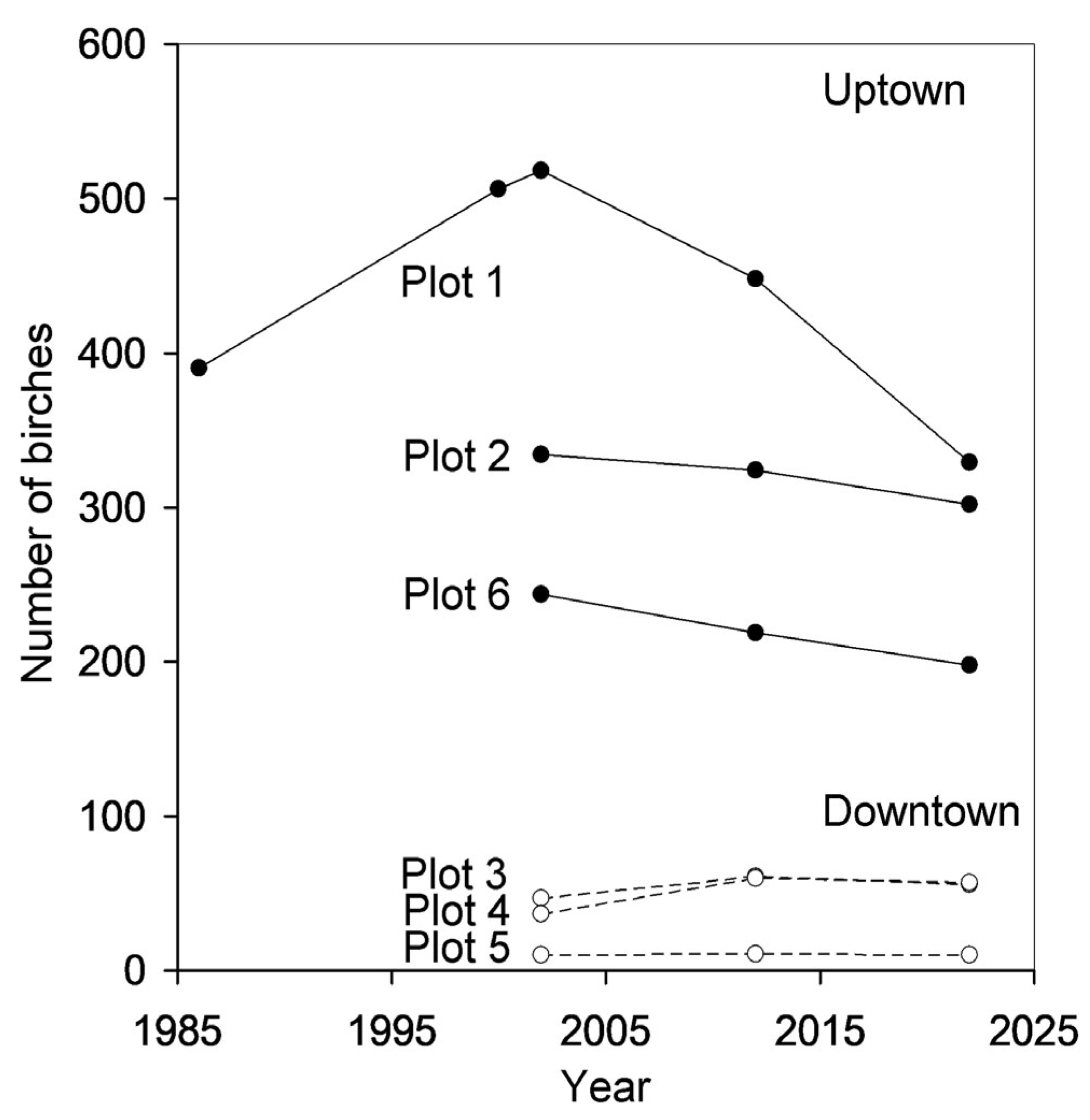
3.1. Outcomes of Ground Surveys

We recorded a total of 1367 unique birch individuals across censuses: 1190 in 2002, 1036 in 2012, and 952 in 2022 (Table S2); many trees were recounted in multiple years. From 2002 to 2022, the total number of birches in the three uptown plots declined from 1096 to 829, while in the three downtown plots, it increased from 94 to 123 (Figure 2). The majority of birches were found in inner courtyards, with only 5% classified as street trees. The proportion of small birches (basal trunk diameter <10 cm) in our plots ranged from 0% to 52% and varied significantly across the censuses (Table 2), shifting from an average of (mean ± S.E.) 7.3 ± 2.9% in 2002 to 20.9 ± 8.1% in 2012 and then to 11.2 ± 4.6% in 2022 (Table S2). This proportion did not differ between downtown and uptown plots (Table 2) and did not correlate with the distance from the city centre (r = –0.45, n = 6 blocks, p = 0.37).
Throughout the study period, we observed 177 juvenile birches emerging in our plots, and classified 45 of these as planted (Table S2). In downtown plots, self-established birches were only observed in pavement cracks and on the roofs of low buildings, whereas in uptown plots, they were primarily observed on uncut lawns. Of the 113 birches that self-established between 2002 and 2012, only 26 survived until 2022, with survivors concentrated in the two uptown blocks furthest from the city centre. The survival of planted birches was significantly higher (22 out of 24 individuals; difference from survival of self-established birches: χ2 = 15.3, d.f. = 1, p < 0.0001).
Throughout the study period, a total of 415 birches disappeared from our plots, including 89 juveniles that emerged from 2002 to 2012. In 2012, we observed 12 dead standing large birches, which had disappeared by 2022. However, another 12 large birches were classified as freshly dead or dying in 2022. In total, 19 large birches were felled from our uptown plots due to the construction of six buildings, while the development of recreational infrastructure, primarily the construction of seven playgrounds, resulted in the removal of an additional 53 large birches. Thus, contrary to prediction (4), urban development directly accounted for only 17% of birches lost from our study plots.

3.2. Outcomes of Remote Sensing

The proportion of vegetated area (covered by trees and herbaceous plants) in our plots (Table S3) ranged from 2.1% to 63.2%, with uptown plots exhibiting five times more vegetated area than downtown plots (Figure 3a; Table 2). From 2002 to 2022, this proportion decreased significantly (Table 2), with downtown plots experiencing nearly double the decrease compared to uptown plots (Figure 3a; Table 2). During all study years, the proportion of vegetated area in our plots increased, with an increase in distance from the city centre (r = 0.85 to 0.89, n = 6, p = 0.02 to 0.03).
Trees in our plots covered 2.1% to 45.9% of the total area, with uptown plots exhibiting four times greater tree cover than downtown plots (Figure 3b; Table 2). From 2002 to 2022, this proportion decreased significantly (Figure 3b), with a similar rate seen in both uptown and downtown plots (Table 2). The negative correlation between the proportion of area covered by trees and distance from the city centre increased during our study (2002: r = −0.72, n = 6, p = 0.11; 2012: r = −0.82, n = 6, p = 0.05; 2022: r = −0.91, n = 6, p = 0.01).

3.3. Patterns in Birch Population Density

The absolute BPD (i.e., per unit of total area) in our plots ranged from 0.38 to 17.06 trees ha−1, with an average of 6.55 trees ha−1. In uptown plots, the absolute BPD was seven times greater than in downtown plots (Figure 4a; Table 2), confirming prediction (1). The rate of spatial change in BPD, estimated through the regression analysis of BPD values averaged across the study period, was 1.87 ± 0.52 trees ha−1 km−1 (R2 = 0.76, p = 0.02).
From 2002 to 2022, the absolute BPD decreased by 23% in the uptown plots and increased by 31% in the downtown plots. This difference in temporal trends between uptown and downtown plots approached statistical significance (Table 2). Thus, prediction (2) was confirmed for uptown plots, where the rate of temporal change in absolute BPD was −0.15 ± 0.02 trees ha−1 year−1, but not for downtown plots.
Meanwhile, the relative BPD in the uptown plots (i.e., per unit of vegetated area) ranged from 10.14 to 35.29 trees ha−1, averaging 21.03 trees ha−1 (Figure 4b). The relative BPD in uptown plots was only twice as great as in downtown plots, with this difference being marginally significant (Table 2).
During the study period, the relative BPD decreased by 10% in uptown plots and increased by 50% in downtown plots, but this difference in temporal trends between uptown and downtown plots did not reach statistical significance (Table 2). Thus, in line with prediction (3), changes in absolute BPD were driven by changes in the area of habitats suitable for tree growth.
On average, the absolute BPD of planted birches was three times greater in downtown plots than in uptown plots (Figure 4c), while the absolute BPD of self-established birches showed the opposite pattern (Figure 4d). However, these differences did not reach statistical significance (Table 2).

4. Discussion

4.1. Spatial Changes in Birch Population Density

Data on changes in plant population density along urbanization gradients are surprisingly scarce. In Minneapolis (MN, USA), tree canopy cover remained constant with the distance from the urban core from 1937 to 1970 but exhibited a dome-shaped pattern from 1991 to 2009, with increases in canopy cover observed at moderate urbanization levels 15–25 km from the urban core [23]. Across eight cities in Poland, the percentage of tree cover (a proxy of tree abundance across all species) decreased fourfold from urban parks to the city centre [37]. Similarly, in residential areas of Beijing (China), tree density decreased approximately twofold between plots located 15 and 2 km from the city centre ([27]; W. Zhou, pers. comm.), a trend consistent with our finding of a sevenfold decrease in absolute BPD between plots located 8 and 2 km from the centre of St. Petersburg.
In contrast, the relative BPD did not statistically differ between our uptown and downtown plots. Thus, the observed difference in absolute BPD between downtown and uptown areas of St. Petersburg primarily results from the fivefold difference in the proportion of urban areas suitable for plant growth. The latter difference is intrinsically linked to variation in urban development practices between the time periods when these parts of the city were built.

4.2. Temporal Changes in Birch Population Density

Despite many cities having plans for biodiversity conservation and the enhancement of ecosystem services [38], urban tree cover globally is experiencing a slow but significant decline, falling at a rate of 0.15% year−1 [39]. The number of birches in the monitored plots in St. Petersburg has decreased much faster, at a rate of 1% year−1 from 2002 to 2022, despite both natural regeneration and planting. This decline extends beyond birches and affects all urban trees. For instance, in the Vasileostrovskij district of St. Petersburg, municipal agencies cut down 1514 trees from 1997 to 2002 but planted only 995 [40]. This downward trend is corroborated by the analysis of Google Earth imagery, which shows an overall decline in both the total vegetation cover and tree cover within our plots from 2002 to 2022, with a fall at a rate of approximately 1% year−1. This sevenfold faster decline of tree populations in St. Petersburg relative to the global average is alarming and calls for improved green area management.
Our most striking findings are the reversal in the direction of the observed temporal changes in the numbers of birches in some of our plots from an increase to decrease over time (Figure 2) and the significant difference in temporal changes in the absolute BPD between downtown and uptown plots (Figure 4a). Effects of urbanization on plant and animal population densities, whether negative or positive, are generally considered monotonic [41,42]. To our knowledge, no existing urban ecology concepts predicted the observed non-monotonic patterns based on habitat changes along urbanization gradients. Similarly, the opposite directions of temporal changes in absolute BPD cannot be inferred from the spatial distribution of BPD within the city of St. Petersburg. We therefore suggest that this pattern emerged due to differences in management practices or residents’ attitudes towards urban greenery between downtown and uptown areas.
The densely built-up downtown imposes more stress on plants compared to the sparsely built-up uptown, primarily due to pollution and overheating in the downtown core [43,44]. Nevertheless, we did not observe the expected difference in the rate of birch disappearance between downtown and uptown sites. By 2022, both areas had lost a similar proportion (ca. 35%) of the birches recorded in 2002 (Table S2). This similarity arose because a significant number of birches were removed from the uptown plots for reasons unrelated to their health, such as the construction of new buildings and children’s playgrounds. In contrast, similar activities did not result in the disappearance of even a single birch from the downtown plots.
From 2017 to 2021, the government of St. Petersburg planted 0.08 to 0.22 trees ha−1 year−1 in the administrative districts that included our plots (www.gov.spb.ru; accessed 10 February 2025). These planting rates are comparable to those observed for birch planting. However, the governmental data encompass all tree species, with birches constituting 5% to 25% of the total number of planted trees in different years [28]. We therefore conclude that the majority of birches in our plots were likely planted by local residents rather than by municipal authorities. This inference is supported by the observed manner of birch planting. First, nearly all birches were planted in inner courtyards away from the streets, while governmental agencies usually plant trees along streets or in parks and public gardens. Second, birches were predominantly planted solitarily or in small groups, whereas governmental agencies typically plant trees in large groups. Third, at the time of planting, the observed birches were 0.5 to 1.5 m tall, indicating that they were transplanted from rural areas rather than bought from nurseries, which usually sell birches that are 3–4 m tall (e.g., www.gardensprofi.ru; accessed 13 May 2025).
We observed three times more planted birches (per unit of total area) in the downtown plots than in the uptown plots (Table S2). This disparity may suggest that, due to the scarcity of greenery in downtown areas, urban trees are valued by downtown residents more than by people living in greener uptown areas. Consequently, downtown residents may be more proactive in increasing the number of trees in their neighbourhoods. Thus, the temporal changes in urban birch populations may reflect an interplay between natural processes (mortality, regeneration) and societal factors. In St. Petersburg, where government-led tree planting efforts are insufficient to maintain existing green spaces [40], these societal processes may play a particularly significant role. Therefore, we propose that the reversal of the temporal trend in BPD within the historical city centre is likely driven by societal rather than natural processes. Hence, we support the suggestion [16] that future research on urban tree regeneration and survival should consider both natural and human components.

4.3. Limitations of Space-for-Time Substitution in Urban Ecology

Our discovery of opposite temporal trends in the absolute BPD in uptown and downtown plots of St. Petersburg clearly highlights the substantial limitations of using space-for-time substitution to predict temporal changes in the population density of various organisms in large cities. These limitations arise from the superposition of natural and societal processes, the outcomes of which are challenging to predict.
We propose that the impact of societal processes on urban biota varies among taxa, being most pronounced for those groups of organisms that garner the greatest public attention and that can benefit from simple and cost-effective measures. We suggest that these processes are particularly impactful for trees, birds, and pollinating insects such as bees, moths, and butterflies. However, the current level of knowledge does not enable us to predict the conditions under which societal processes become influential enough to distort ecological patterns driven by natural processes in urban areas.

4.4. Future of the Birch Population in St. Petersburg

A previous study concluded that the birch population in uptown residential areas of St. Petersburg increased from 1986 to 2000 due to intensive planting [30]. Surprisingly, this increase reversed to a decrease in the early 2000s. This change likely reflects the ageing of the birch population due to insufficient regeneration, a process previously shown to result in birch decline near a large industrial polluter [45]. This suggestion is supported by the extremely low proportion of small birches in urban areas (10%) relative to old-grown taiga forests (89–97%: [46]). Combined with the low survival rate of self-established birches, this finding underscores the need to intensify planting efforts to maintain BPD in the uptown area.
If the rate of birch population decline in the uptown area remains consistent with our observations from 2002 to 2022, then the absolute BPD in uptown St. Petersburg will reach the level currently observed in the downtown core in about 75 years. However, this projection seems unrealistic, as current urban planning practices [47] suggest that impervious cover in uptown areas will never increase to the level currently seen in downtown St. Petersburg. A more plausible scenario is that in 10–20 years, uptown residents will recognize the value of their declining greenery and either pressure the city government to intensify tree planting or begin planting trees themselves. The spontaneous planting of trees by urban dwellers will likely lead to an increase in the proportion of birches among urban trees, because birch seedlings, unlike ornamental tree seedlings, can be easily transplanted from surrounding rural areas. The outcome will be a city more hospitable to native animals, mainly insects, associated with birch trees.

5. Conclusions

The key methodological contribution of this study is the comparison of ground survey data from 2002, 2012 and 2022, which enables us to track birch population dynamics at the level of individual trees and identify potential drivers of these dynamics. Although the data were collected in a single city, our conclusions are not confined to this specific location. The urbanization patterns, societal drivers, and ecological responses we observed in St. Petersburg reflect broader dynamics that are common across many urban environments worldwide. Our findings stress the importance of long-term studies, challenge the predictive power of space-for-time substitution in urban ecosystems and emphasize that future urban ecology research should account for both natural and societal processes. Further similarly designed studies are needed to identify the conditions under which societal processes become influential enough to alter ecological patterns shaped by natural processes in urban areas.

Supplementary Materials

The following supporting information can be downloaded at: https://www.mdpi.com/article/10.3390/earth6020041/s1, Table S1: Location of study plots; Table S2: Outcomes of birch censuses; Table S3: Area covered by herbs and trees (m2).

Author Contributions

Conceptualization, M.V.K.; methodology, M.V.K., E.V.-C. and V.Z.; formal analysis, M.V.K.; investigation, M.V.K., E.V.-C. and V.Z.; data curation, M.V.K.; writing—original draft preparation, M.V.K.; writing—review and editing, E.V.-C. and V.Z.; visualization, M.V.K., E.V.-C. and V.Z. All authors have read and agreed to the published version of the manuscript.

Funding

This study was funded by the Research Council of Finland, grant numbers 122133 and 259854.

Data Availability Statement

The data are available from Supplementary Materials.

Acknowledgments

We thank A. L. Lvovsky and I. Afán for assistance in data collection, W. Zhou and A. Egorov for clarification of published data, and E. L. Zvereva for inspiring comments to an earlier draft of this manuscript.

Conflicts of Interest

The authors declare no conflicts of interest. The funders had no role in the design of the study; in the collection, analyses, or interpretation of data; in the writing of the manuscript; or in the decision to publish the results.

Abbreviations

The following abbreviations are used in this manuscript:
BPDbirch population density
E.V.-C.Elena Valdés-Correcher
M.V.K.Mikhail V. Kozlov
V.Z.Vitali Zverev

References

  1. Liu, Z.; He, C.; Zhou, Y.; Wu, J. How much of the world’s land has been urbanized, really? A hierarchical framework for avoiding confusion. Landsc. Ecol. 2014, 29, 763–771. [Google Scholar] [CrossRef]
  2. United Nations. World Urbanization Prospects: The 2018 Revision; ST/ESA/SER.A/420; United Nations: New York, NY, USA, 2018. [Google Scholar]
  3. OECD. Cities in the World: A New Perspective on Urbanisation; OECD Publishing: Paris, France, 2020. [Google Scholar]
  4. Seto, K.C.; Güneralp, B.; Hutyra, L.R. Global forecasts of urban expansion to 2030 and direct impacts on biodiversity and carbon pools. Proc. Natl. Acad. Sci. USA 2012, 109, 16083–16088. [Google Scholar] [CrossRef] [PubMed]
  5. Niemelä, J. Ecology of urban green spaces: The way forward in answering major research questions. Landsc. Urban Plan. 2014, 125, 298–303. [Google Scholar] [CrossRef]
  6. Grimm, N.B.; Faeth, S.H.; Golubiewski, N.E.; Redman, C.L.; Wu, J.; Bai, X.; Briggs, J.M. Global change and the ecology of cities. Science 2008, 319, 756–760. [Google Scholar] [CrossRef]
  7. McDonald, R.I.; Colbert, M.L.; Hamann, M.; Simkin, R.; Walsh, B. Nature in the Urban Century: A Global Assessment of Where and How to Conserve Nature for Biodiversity and Human Wellbeing; The Nature Conservancy: Arlington, VA, USA, 2018. [Google Scholar]
  8. Luna, A.; Romero-Vidal, P.; Hiraldo, F.; Tella, J.L. Cities may save some threatened species but not their ecological functions. PeerJ 2018, 6, e4908. [Google Scholar] [CrossRef]
  9. Planchuelo, G.; Kowarik, I.; von der Lippe, M. Plant traits, biotopes and urbanization dynamics explain the survival of endangered urban plant populations. J. Appl. Ecol. 2020, 57, 1581–1592. [Google Scholar] [CrossRef]
  10. Kozlov, M.V. Changes in distribution of an archaic moth, Micropterix calthella in St. Petersburg, Russia, between 1989 and 2005. J. Biogeogr. 2007, 34, 231–236. [Google Scholar] [CrossRef]
  11. Beninde, J.; Veith, M.; Hochkirch, A. Biodiversity in cities needs space: A meta-analysis of factors determining intra-urban biodiversity variation. Ecol. Lett. 2015, 18, 581–592. [Google Scholar] [CrossRef]
  12. Song, X.P.; Tan, P.Y.; Edwards, P.; Richards, D. The economic benefits and costs of trees in urban forest stewardship: A systematic review. Urban Forest. Urban Green. 2018, 29, 162–170. [Google Scholar] [CrossRef]
  13. Esperon-Rodriguez, M.; Power, S.A.; Tjoelker, M.G.; Rymer, P.D. Future climate risk and urban tree inventories in Australian cities: Pitfalls, possibilities and practical considerations. Urban Forest. Urban Green. 2022, 78, 127769. [Google Scholar] [CrossRef]
  14. Von Döhren, P.; Haase, D. Geospatial assessment of urban ecosystem disservices: An example of poisonous urban trees in Berlin, Germany. Urban Forest. Urban Green. 2022, 67, 127440. [Google Scholar] [CrossRef]
  15. Sjöman, H.; Östberg, J.; Bühler, O. Diversity and distribution of the urban tree population in ten major Nordic cities. Urban Forest. Urban Green. 2012, 11, 31–39. [Google Scholar] [CrossRef]
  16. Vogt, J.M.; Watkins, S.L.; Mincey, S.K.; Patterson, M.S.; Fischer, B.C. Explaining planted-tree survival and growth in urban neighborhoods: A social–ecological approach to studying recently-planted trees in Indianapolis. Landsc. Urban Plan. 2015, 136, 130–143. [Google Scholar] [CrossRef]
  17. Smart, N.; Eisenman, T.S.; Karvonen, A. Street tree density and distribution: An international analysis of five capital cities. Front. Ecol. Evol. 2020, 8, 562646. [Google Scholar] [CrossRef]
  18. Ren, X.C.; Torquato, P.R.; Arndt, S.K. Urban density does not impact tree growth and canopy cover in native species in Melbourne, Australia. Urban Forest. Urban Green. 2023, 81, 127860. [Google Scholar] [CrossRef]
  19. Martinuzzi, S.; Locke, D.H.; Ramos-González, O.; Sanchez, M.; Grove, J.M.; Muñoz-Erickson, T.A.; Arendt, W.J.; Bauer, G. Exploring the relationships between tree canopy cover and socioeconomic characteristics in tropical urban systems: The case of Santo Domingo, Dominican. Urban Forest. Urban Green. 2021, 62, 127125. [Google Scholar] [CrossRef]
  20. Mix, C.; Hunt, N.; Stuart, W.; Hossain, A.; Bishop, B.W. A spatial analysis of urban tree canopy using high-resolution land cover data for Chattanooga, Tennessee. Appl. Sci. 2024, 14, 4861. [Google Scholar] [CrossRef]
  21. Ock, Y.; Shandas, V.; Ribeiro, F.; Young, N. Drivers of tree canopy loss in a mid-sized growing city: Case study in Portland, OR (USA). Sustainability 2024, 16, 1803. [Google Scholar] [CrossRef]
  22. Locke, D.H.; Ossola, A.; Schmit, J.P.; Grove, J.M. Sub-parcel scale analysis is needed to capture socially-driven canopy cover change in Baltimore, MD. Landsc. Urban Plan. 2025, 253, 1505187. [Google Scholar] [CrossRef]
  23. Berland, A. Long-term urbanization effects on tree canopy cover along an urban–rural gradient. Urban Ecosyst. 2012, 15, 721–738. [Google Scholar] [CrossRef]
  24. Bonney, M.T.; He, Y. Attributing drivers to spatio-temporal changes in tree density across a suburbanizing landscape since 1944. Landsc. Urban Plan. 2019, 192, 103652. [Google Scholar] [CrossRef]
  25. Carreiro, M.M.; Tripler, C.E. Forest remnants along urban–rural gradients: Examining their potential for global change research. Ecosystems 2005, 8, 568–582. [Google Scholar] [CrossRef]
  26. Nagy, R.C.; Lockaby, B.G. Urbanization in the Southeastern United States: Socioeconomic forces and ecological responses along an urban-rural gradient. Urban Ecosyst. 2011, 14, 71–86. [Google Scholar] [CrossRef]
  27. Jiao, M.; Xue, H.; Yan, J.; Zheng, Z.; Wang, J.; Zhao, C.; Zhang, L.; Zhou, W. Tree abundance, diversity and their driving and indicative factors in Beijing’s residential areas. Ecol. Indic. 2021, 125, 107462. [Google Scholar] [CrossRef]
  28. Kozlov, M.V. Changes in distribution of birches and birch-feeding Eriocrania moths in St. Petersburg, Russia, between 1986 and 2001. J. Biogeogr. 2002, 29, 913–918. [Google Scholar] [CrossRef]
  29. Firsov, G.A.; Egorov, A.A.; Fadeyeva, I.V.; Byalt, V.V. To the question of the assortment of arboreal plants of the Saint-Petersburg’s city parks. Hortus Bot. 2010, 5, 1–14. (In Russian) [Google Scholar]
  30. Atkinson, M.D. Betula pendula Roth. (B. verrucosa Ehrh.) and B. pubescens Ehrh. J. Ecol. 1992, 80, 837–870. [Google Scholar] [CrossRef]
  31. Fedotova, N.B. Green spaces of St. Petersburg and monitoring of their conditions. For. Bull. 2009, 13, 202–206. (In Russian) [Google Scholar]
  32. Kovyazin, V.F.; Lipetskaya, A.A.; Nguyen, T.L. Diversity and ecological condition of plants in Saint Petersburg. In Actual Problems of the Forest Complex; Pamphilov, E.A., Ed.; Bryansk State Engineering and Technology Academy: Bryansk, Russia, 2015; Volume 41, pp. 190–193. (In Russian) [Google Scholar]
  33. Eränen, J.K.; Nielsen, J.; Zverev, V.E.; Kozlov, M.V. Mountain birch under multiple stressors—Heavy metal resistant populations co-resistant to biotic stress but maladapted to abiotic stress. J. Evol. Biol. 2009, 22, 840–851. [Google Scholar] [CrossRef]
  34. Goryshina, T.K. Greenery of the Old Petersburg; Iskusstvo-SPB: St. Petersburg, Russia, 2003. (In Russian) [Google Scholar]
  35. Nwilo, P.C.; Okolie, C.J.; Onyegbula, J.C.; Arungwa, I.D.; Ayoade, O.Q.; Daramola, O.E.; Orji, M.J.; Maduako, I.D.; Uyo, I.I. Positional accuracy assessment of historical Google Earth imagery in Lagos State, Nigeria. Appl. Geomat. 2022, 14, 545–568. [Google Scholar] [CrossRef]
  36. SAS Institute. SAS/Stat. User’s Guide, Version 9.2; SAS Institute: Cary, NC, USA, 2009. [Google Scholar]
  37. Chatelain, M.; Da Silva, A.; Celej, M.; Kurek, E.; Bulska, E.; Corsini, M.; Szulkin, M. Replicated, urban-driven exposure to metallic trace elements in two passerines. Sci. Rep. 2021, 11, 19662. [Google Scholar] [CrossRef] [PubMed]
  38. Nilon, C.H.; Aronson, M.F.J.; Cilliers, S.S.; Dobbs, C.; Frazee, L.J.; Goddard, M.A.; O’Neill, K.M.; Roberts, D.; Stander, E.K.; Werner, P.; et al. Planning for the future of urban biodiversity: A global review of city-scale initiatives. BioScience 2017, 67, 332–342. [Google Scholar] [CrossRef]
  39. Nowak, D.J.; Greenfield, E.J. The increase of impervious cover and decrease of tree cover within urban areas globally (2012–2017). Urban Forest. Urban Green. 2020, 49, 126638. [Google Scholar] [CrossRef]
  40. Kovyazin, V.F.; Makarov, A.I.; Minkevich, I.I.; Polovtsev, I.N. The State of Greenery in Vasileodtrovskij District of Saint Petersburg; Saint Petersburg Union of Gardeners: St. Petersburg, Russia, 2006. (In Russian) [Google Scholar]
  41. Gaston, K.J. Urban Ecology; Cambridge University Press: Cambridge, UK, 2010. [Google Scholar]
  42. Lewis, J.S.; Logan, K.A.; Alldredge, M.W.; Bailey, L.L.; VandeWoude, S.; Crooks, K.R. The effects of urbanization on population density, occupancy, and detection probability of wild felids. Ecol. Appl. 2015, 25, 1880–1895. [Google Scholar] [CrossRef]
  43. Calfapietra, C.; Peñuelas, J.; Niinemets, Ü. Urban plant physiology: Adaptation-mitigation strategies under permanent stress. Trends Plant Sci. 2015, 20, 72–75. [Google Scholar] [CrossRef]
  44. Czaja, M.A.; Kołton, A.; Muras, P. The complex issue of urban trees—Stress factor accumulation and ecological service possibilities. Forests 2020, 11, 932. [Google Scholar] [CrossRef]
  45. Zverev, V.E. Mortality and recruitment of mountain birch (Betula pubescens ssp. czerepanovii) in the impact zone of a copper-nickel smelter in the period of significant reduction of emissions: The results of 15-year monitoring. Russ. J. Ecol. 2009, 40, 254–260. [Google Scholar] [CrossRef]
  46. Stavrova, N.I.; Gorshkov, V.V.; Katjutin, P.N. Dynamics of tree distribution in Siberian spruce and white birch populations according to trunk diameter in the course of postfire succession in northern taiga spruce forests. Lesovedenie Russ. J. For. Sci. 2010, 2010, 21–31. (In Russian) [Google Scholar]
  47. Hansen, R.; Olafsson, A.S.; van der Jagt, A.P.N.; Rall, E.; Pauleit, S. Planning multifunctional green infrastructure for compact cities: What is the state of practice? Ecol. Indic. 2019, 96, 99–110. [Google Scholar] [CrossRef]
Figure 1. Location of study plots (squares) within city of St. Petersburg relative to its centre, Palace Square (filled circle). For characteristics of individual plots, see Table 1; for coordinates of plot corners, see Table S1. Insert: location of St. Petersburg (red square) in Europe.
Earth 06 00041 g001
Figure 2. Changes in the number of birches in study plots during the observation period. Open circles: downtown plots; filled circles: uptown plots. Data from 1986 and 2000 are from [28]. For characteristics of individual plots, see Table 1.
Earth 06 00041 g002
Figure 3. The proportion of plot area covered by vegetation (a) and tree canopies (b) during the observation years. Open circles: downtown plots; filled circles: uptown plots. For statistical analyses, see Table 2.
Earth 06 00041 g003
Figure 4. Birch population density: all trees per total plot area (a), all trees per vegetated plot area (b), planted trees per total plot area (c), self-established trees per total plot area (d). Open circles: downtown plots; filled circles: uptown plots. For statistical analyses, see Table 2.
Earth 06 00041 g004
Table 1. Characteristics of the study plots.
City AreaPlotDistance a, kmYear of Building ErectionArea (ha)
First bCurrent cTotalVegetated d
Uptown18.11940197030.3613.74
Uptown26.01930196424.6713.50
Downtown32.41730190722.882.96
Downtown42.71730189424.183.04
Downtown52.01730188226.070.77
Uptown67.61930195230.5410.86
a distance from the city centre (the Palace Square). b data from https://retromap.ru (accessed on 13 May 2025) and from https://dom.mingkh.ru/sankt-peterburg (accessed on 13 May 2025), rounded to the nearest 10 years. c data averaged across the buildings located along the perimeter of a plot. d the area covered by herbs, shrubs, and trees (averaged from 2002, 2012 and 2022).
Table 2. Sources of variation in birch population characteristics (repeated measures ANOVA: SAS GLM procedure, type 3 sum of squares).
Characteristics of Birch PopulationsStudy Area (Uptown vs. Downtown)Study YearStudy Area × Study Year
StatisticspStatisticspStatisticsp
Proportion of area covered by vegetationF1,4 = 31.70.0049F2,8 = 17.10.0013F2,8 = 2.830.12
Proportion of area covered by treesF1,4 = 18.20.0130F2,8 = 17.80.0011F2,8 = 2.810.12
Proportion of small birchesF1,4 = 1.980.23F2,8 = 5.580.0304F2,8 = 3.170.10
Absolute birch population densityF1,4 = 19.20.0119F2,8 = 2.660.13F2,8 = 4.250.0554
Relative birch population densityF1,4 = 6.070.07F2,8 = 3.980.06F2,8 = 2.450.15
Absolute density of planted birchesF1,4 = 2.260.21F1,4 = 0.230.66F1,4 = 1.750.26
Absolute density of self-established birchesF1,4 = 0.960.38F1,4 = 1.260.33F1,4 = 0.180.70
Disclaimer/Publisher’s Note: The statements, opinions and data contained in all publications are solely those of the individual author(s) and contributor(s) and not of MDPI and/or the editor(s). MDPI and/or the editor(s) disclaim responsibility for any injury to people or property resulting from any ideas, methods, instructions or products referred to in the content.

