Article

Index-Based Alteration of Long-Term River Flow Regimes Influenced by Land Use Change and Dam Regulation

by
Raoof Mostafazadeh
1,*,
Mostafa Zabihi Silabi
2,
Javanshir Azizi Mobaser
3 and
Bita Moezzipour
4
1
Department of Natural Resources, Faculty of Agriculture and Natural Resources, Water Management Research Center, University of Mohaghegh Ardabili, Ardabil 5951816687, Iran
2
Department of Watershed Management Engineering, Faculty of Natural Resources and Marine Sciences, Tarbiat Modares University, Noor 46414-356, Iran
3
Department of Water Engineering, Faculty of Agriculture and Natural Resources, Water Management Research Center, University of Mohaghegh Ardabili, Ardabil 5951816687, Iran
4
Department of Natural Resources, Faculty of Agriculture and Natural Resources, University of Mohaghegh Ardabili, Ardabil 5951816687, Iran
*
Author to whom correspondence should be addressed.
Earth 2024, 5(3), 404-419; https://doi.org/10.3390/earth5030023
Submission received: 12 July 2024 / Revised: 24 August 2024 / Accepted: 29 August 2024 / Published: 31 August 2024

Abstract

:
The growing population and expansion of rural activities, along with changing climatic patterns and the need for water during drought periods, have led to a rise in the water demand worldwide. As a result, the construction of water storage structures such as dams has increased in recent years to meet the water needs. However, dam construction can bring significant alterations to the natural flow regime of rivers, and it is therefore essential to understand the potential effects of human structures on the hydrological regime of rivers to reduce their destructive impacts. This study analyzes the hydrological changes in the Shahrchai River in response to the Shahrchai Dam construction in Urmia, Iran. The study period was from 1950 to 2017 at the Urmia Band station. The Indicators of Hydrological Alteration (IHA) were used to analyze the hydrological changes before and after regulating, accounting for land use changes and climatic factors. The results revealed the adverse effects of the Shahrchai Dam on the hydrological indices. The analysis showed an increase in the average flow rate during the summer season and a decrease in other seasons. However, the combined effects of water transferring for drinking purposes, a decrease in permanent snow cover upstream of the dam, and an increase in water use for irrigation and agricultural purposes resulted in a decrease in the released river flow. Furthermore, the minimum and maximum daily flow rates decreased by approximately 85% and 65%, respectively, after the construction of the Shahrchai Dam. Additionally, the number of days with maximum flow rates increased from 117 days in the pre-dam period to 181 days in the post-dam period. As a concluding remark, the construction of the Shahrchai Dam, land use/cover changes, and a decrease in permanent snow cover had unfavorable effects on the hydrological regime of the river. Therefore, the hydrological indicators should be adjusted to an acceptable level compared to the natural state to preserve the river ecosystem. The findings of this study are expected to guide water resource managers in regulating the sustainable flow regime of permanent rivers.

1. Introduction

Rivers provide numerous services to humans, including drinking water, industry, agriculture, tourism, nutrient cycling, and habitats for plants and animals. Additionally, they play a crucial role in altering the structure and function of ecological processes, wetlands, and riverine ecosystems [1]. However, human interventions such as dam construction, land use change, inter-basin water transfer, and an increase in water use for various purposes have brought significant changes to the hydrological regimes of rivers in most parts of Iran in recent decades [2]. These interventions and the natural variability in climatic variables have both positive and negative effects on riverine ecosystems, which have been well documented in the literature [3,4,5,6]. For instance, building a dam can have positive effects such as reducing large floods, storing water for the dry season, and generating electricity. However, dam construction can also decrease downstream river flow, which can have severe effects on downstream riverine ecosystems [7,8]. The intensified alterations to the flow regime resulting from dams and land use change have negative impacts on the hydrological and ecological services of the watershed, which increases the vulnerability of stakeholders [9]. Therefore, optimizing the operation of dams and upland land use planning must be managed in a way that preserves the functions and values of aquatic ecosystems for sustainable river management. In this regard, sustainable river management necessitates sufficient environmental flows in the river [10,11]. Therefore, it is essential to evaluate the flow characteristics of rivers before and after altering the flow regime. Over the years, various methods and indicators have been developed to define different components of the flow regime and their impact on the ecological status of river systems and the effects of human activities such as dam construction on altering the river’s flow regime [12]. More than 170 indicators have been proposed in articles for quantifying hydrological changes [13,14]. However, many of these indicators are only used for studying specific parameters, such as the Monthly Peak Flow or Duration of Flow [15,16]. Nevertheless, over time, more comprehensive tools have been developed for assessing a wide range of hydrological change parameters [17,18]. Among these tools, the indicators of hydrologic alteration (IHA) method is widely used, which considers 33 hydrological indicators and 34 environmental flow components to define flow characteristics in the river [19]. Zuo and Liang [1] reported that one of the considerable advantages of the IHA method is that it includes the range of variability approach, which can evaluate flow characteristics in two different periods (i.e., before and after altering the flow regime). Due to its simplicity, its strong theoretical background, and the involvement of relevant hydrological and biological indicators, water and environmental experts have paid attention to studying natural flow regime alterations, including dams and other diversion structures such as hydroelectric power plants [20,21,22]. Koel and Sparks [23] also stated that the IHA method is a useful tool that provides valuable information for maintaining water levels to some extent to preserve fish and other animal and plant needs. Shiau and Wu [24] used IHA to understand flow deviation in the Peinan River in eastern Taiwan and reported that the IHA method is easy to use and provides almost all of the necessary information related to flow deviation and helps estimate the potential impact that flow alteration may have on the ecosystem. Furthermore, the results of the IHA method provide significant information for water resource managers and environmental experts [1]. In recent years, the IHA method has been widely used to assess hydrological changes and impacts on riverine ecosystems due to human interventions such as dam construction, inter-basin water transfer, and an increase in water use for various purposes [12]. Therefore, the IHA method is an important tool for understanding the impacts of human activities on riverine ecosystems and for developing sustainable river management practices.
Numerous studies have investigated the impacts of anthropogenic stressors on river regimes for various purposes. For instance, Yang et al. [17] studied the hydrological changes caused by dam construction on the Yellow River in China, and their findings showed a significant alteration of approximately 56% downstream of the dam. Kumar et al. [25] assessed the effects of Isapur and Arunavati dams on Penganga river flow regimes using the IHA framework. They found significant changes in 26 flow parameters, with alterations ranging from −5.56% to −100%. The Isapur dam had a greater impact on flow regimes than the Arunavati dam, particularly after the inception of a single dam. Fang et al. [26] studied dam impacts on the Liujiaping River, China, using an improved indicators of hydrological alteration (IIHA) framework. They found significant changes in flow regimes post-dam, with their methods effectively capturing intra-annual flow variations and indicating high levels of alteration. Khoeun et al. [27] examined the impact of hydropower dams on streamflow in the Sekong and Sesan rivers of the Lower Mekong Basin. Their analysis revealed significant increases in both low and high flow magnitudes post-dam construction, with the Sekong River’s minimum flow rising by 290% to 412% and the Sesan River’s by 120% to 160%. Similarly, Legleiter [28] examined the effects of a reservoir dam on the Savery River in the United States and found that the dam construction led to a decrease in the peak flow magnitude during spring and an increase in the base flow. Li et al. [29] evaluated the changes in the hydrological regime of the Mekong River in Vietnam caused by dams and found that dam construction resulted in a decrease and increase in flow during the wet and dry seasons, respectively. Ali et al. [8] investigated the effects of cascade hydropower dams on the hydrological indices of the Yangtze River in China at two stations, Cuntan and Miaohe. Their study was conducted for the period of 2003–2015, and the results showed both the positive and negative effects of the dams on the two stations. The flows had positive impacts in July, while these were low for the study stations in October. The minimum daily flow in Miaohe decreased by 7%, while the maximum daily flow in Cuntan decreased by 2%. López-Ballesteros et al. [30] evaluated the future hydrological changes resulting from climate change in the Aracthos basin using the Soil and Water Assessment Tool and hydrological change indices software. Their results showed a decrease in precipitation and streamflow during the period of 2070–2099 compared to the period of 1970–1999. Moreover, the changes could significantly increase the duration of drought periods and affect the resilience of river species and hydraulic and environmental diversity.
In another study, Kumar and Jayakumar [31] examined the hydrological changes in the Krishna River in India caused by human activities. Their results indicated that the hydrological changes in the Krishna River were due to human activities. Song et al. [32] analyzed the hydrological changes of 35 hydrological stations in China under the influence of dam construction. Their findings showed that the hydrological regimes of rivers in China change by an average of 52% due to dam reservoirs.
Moreover, hydrological indices are significantly altered, with the average degree of alteration ranging from 36% to 63%. Mezger et al. [33] evaluated the downstream hydrological changes in 22 Spanish rivers, and their findings showed that all the studied rivers had significant changes in flow magnitude and timing after dam construction. In contrast, a completely homogeneous trend was observed in dry basins where the average annual flow and severe annual flow significantly decreased. Islam et al. [34] assessed the hydrological changes in the Padma River in Bangladesh caused by the Farakka barrage. The research findings showed a significant negative trend in the average flow during the dry season (January to May). However, the RVA analysis indicated that the mean flow was less than the environmental flow. Akula and Jayakumar [35] analyzed the hydrological changes in the Krishna River basin in India under the influence of five different dams. The analysis results showed that the Nagarjuna Sagar dam had a greater effect on the hydrological change indices than the other dams. Furthermore, out of the 33 calculated parameters, 11 parameters had significant changes due to the dams. The evaluation of the results indicated that the impact of dams on the Krishna River led to a normal hydrological change that could pose a risk to aquatic species. Panditharathne et al. [36] investigated trends, change points, and streamflow changes and their relationship with rainfall in the Nilwala River basin in Sri Lanka. The trend analysis showed significant quantitative statistical trends at the monthly, seasonal, and annual scales of rainfall, while streamflow data showed non-significant trends, except for in December. On the other hand, based on the IHA analysis, the average annual flow during the post-change period (2004–2014) increased by approximately 4.0 m3/s compared to the pre-change period (1991–2003). Additionally, the maximum one-day, three-day, and seven-day flows decreased by approximately 30%, 31%, and 24%, respectively. The minimum 90-day flow increased by 18% if only the significant change in the minimum flow is considered. Recently, Malede et al. [37] evaluated the combined and separate effects of land use/land cover and climate change on hydrological regimes in the Abbay River basin in Ethiopia. They used three sets of climate data (1986–1996, 1997–2007, and 2008–2018) and three sets of land use/land cover maps (1986, 2001, and 2018). The results showed that land use/land cover change increased surface runoff and reduced baseflow, water yield, and evapotranspiration. Climate change also increased surface runoff and water yield while decreasing baseflow and evapotranspiration during 1996–2006. The combined effect of land use/land cover and climate change increased surface runoff and decreased evapotranspiration. IHA did not show any significant increasing trends in the minimum and maximum daily flow for one, three, seven, and thirty days in the Abbay River basin.
Several studies have been conducted in Iran with different objectives, including the evaluation of hydrological flow indices or environmental flow components influenced by dams, land use change, or climate change [38,39], as well as the assessment of hydrological flow indices and environmental flow components in rivers [40]. These studies show that anthropogenic structures such as dam construction can reduce landscape cohesion and increase heterogeneity, thereby affecting the structure and function of ecosystems. Furthermore, many studies have evaluated the impacts of dams on various hydrological and environmental flow indices at different temporal and spatial scales. These studies have found that dam construction can have negative effects on plant and animal species due to changes in hydrological flow indices. However, some studies have also shown that the construction of dams can have positive effects on minimum flow rates, which can be crucial for protecting riverine ecosystems. The literature review emphasizes the importance of water resource management for maintaining desirable ecological conditions and ecosystem cohesion downstream of constructed dams by considering changes in hydrological flow indices within the range of variability approach. This study utilizes a long-term dataset to investigate changes in hydrological indices resulting from land use changes and human-made structures. The main objective is to evaluate the changes in hydrological flow indices of the Shahrchai River before and after the construction of the Shahrchai Dam. Additionally, this study aims to provide comprehensive information on changes in the river regime based on hydrological indices, using the IHA method and the range of variability approach. Understanding the long-term response of the river flow to land use changes and flow regulation by the dam in the urban river can help develop environmental flow management guidelines and protect the river ecosystem.

2. Materials and Methods

2.1. Study Area

The Shahrchai River is a crucial source of drinking water for the city of Urmia and its surrounding areas, as well as an important contributor to Lake Urmia. The river originates from the Zarrineh, Kamal, and Zarrinatābūtan mountains, which have elevations of 3100, 3386, and 3369 m above sea level, respectively. As it flows south to north, it receives tributaries from the Iran–Turkey border mountains and irrigates agricultural lands and orchards in the county before entering Lake Urmia. The Shahrchai River runs in a west-southeast to east-northeast direction, passing through the city of Urmia and irrigating downstream farms and orchards before ultimately flowing into Lake Urmia.
A portion of the river’s flow is allocated to supply drinking water to the city of Urmia, while the remainder passes through irrigating gardens and agricultural lands near the city. Originating from the 3271 m high mountains, it begins its course from the village of Band. The Shahrchai River originates from the 3271 m upland mountains area, and passes through Band village on its way. The Shahrchai Dam in Urmia is an earth-rockfill dam with a clay core, standing 84 m high from the riverbed and stretching 550 m across the Shahrchai River, constructed 12 km southwest of Urmia. Its primary purpose is to provide drinking and industrial water for Urmia and to meet the agricultural water needs of lands downstream of the Shahrchai Dam.
The useful volume of the Shahrchai Dam reservoir is 213 million cubic meters. The annual regulatory water volume of Shahrchai River is about 199 million cubic meters, of which about 76 million cubic meters per year is allocated to supply drinking water to Urmia city. Also, agricultural water needs for 12,500 hectares of Urmia Plain lands is also supplied from the Shahrchai Dam. The watershed area of the Shahrchai River at Band is 396 km2, with an average annual water flow of 168 million cubic meters after allocating drinking water. The Shahrchai Dam is one of the significant structures built along the river, and its construction has significantly impacted the downstream Shahrchai River ecosystem. Therefore, this study focuses on the Urmia Band gauge station, located downstream of the dam for analyzing changes, due to its location and the availability of high-quality data. The location of the Shahrchai watershed, the Shahrchai Dam, and the Urmia Band hydrometric station can be found in Figure 1.

2.2. Methodology

This study aims to assess the changes in the hydrological indices of the Shahrchai River before and after the construction of the Shahrchai Dam. To achieve this objective, the hydrologic alteration indicators were initially calculated using the daily discharge statistics of the Urmia Band hydrometric station. Version 7.1 of the IHA software was used for this purpose. Subsequently, changes in these indices were estimated by identifying the points of change in the river flow discharge values.
The IHA software was developed by The Nature Conservancy in 1990 [41] and is widely used in hydrology to evaluate human-induced stress factors that impact hydrological changes. The IHA includes a total of 67 indices, with 33 indices used for hydrological changes and 34 indices used to assess environmental flow components. The parameters considered in the IHA method are logical and have a strong relationship with river ecosystems, reflecting the impact of human activities on flow regimes, such as the construction of structures like dams, levees, and water diversions [20,42]. The IHA indices are categorized into five groups. The first group includes 12 indices indicating monthly streamflow (m3/s), while the second group includes 11 indices indicating the magnitude and duration of annual extreme flow events (m3/s). The third group consists of two indices indicating the timing of extreme flow events. The fourth and fifth groups include four and three indices, respectively, used to define the frequency and duration of low and high flow pulses, as well as the magnitude and frequency of flow status changes.
The main advantage of using IHA is that it provides multiple indices in a standardized unit and analyzes them using the range of variability approach (RVA). The RVA enables the evaluation of index performance before (pre-impact) and after (post-impact) human intervention in the river regime [8,43]. The RVA component of the IHA software is unique in that it provides a degree of periodicity in the river or watershed. Therefore, the non-parametric RVA was used in this study to evaluate the flow regime of the Shahrchai River. The non-parametric RVA is defined based on percentile values, with target ranges defined within the 25th to 75th percentiles, known as the lower and upper boundaries of RVA [8].
Richter et al. [43] classified changes into three groups: minimal, moderate, and substantial. Values between 0 and 33 percent are classified as minimal changes, 34 to 67 percent as moderate changes, and 68 to 100 percent as substantial changes. Therefore, this study employed IHA to assess the effects of the Shahrchai Dam construction on hydrological changes at the Urmia Band hydrometric station located downstream of the dam. The date of reservoir operation was used as the point of hydrological change for dividing the entire period into a pre-impact and post-impact period. Although the natural movement of water and sediment during the early stages of dam construction may cause disturbance, several years are required to complete construction and fill the dam reservoir to the desired operational level. Therefore, it is reasonable to assume that the date of dam operation indicates the start of the hydrological changes [44]. The construction of the Shahrchai Dam began in 1994 and was put into operation in 2005. Thus, the statistical period of 1990–2005 was considered the pre-impact period, while the statistical period of 2005–2017 was considered the post-impact period for evaluating the hydrological changes of interest in this study.
To implement the IHA model, the daily Dubai data were converted into csv format by observing the date of data registration. Next, based on the dam construction date, the time period before and after the impact of the dam construction was determined based on the available data, and the model was run. It should be noted that in the IHA model, various indicators are calculated based on mathematical concepts and taking into account the different characteristics of the flow regime. The accuracy of the model results has been evaluated in different regions and studies.

3. Results

Table 1 displays the hydrologic alteration indicators (IHA) for the pre- and post-construction periods of the Shahrchai Dam, using the RVA method. The changes in the monthly flow rate at the Urmia Band hydrometric station during the pre- and post-construction periods are illustrated in Figure 2.
The results from Table 1 indicate that the monthly flow rate increased during the summer season, but decreased in the other seasons after the construction of the Shahrchai Dam. The largest decrease in flow rate occurred in April (88%) and May (81%), while the highest increase in flow rate was observed in August and July, with increases of approximately 269% and 48%, respectively, compared to before the dam construction.
Regarding the maximum flow value of 13.80 from March to September, it should be noted that March overlaps with the river’s high-water season. Based on the conditions and seasonal distribution of rainfall in the study area in the mentioned period, due to the filling of the dam capacity, the flow is released. Also, in the months of August and September, the flow of the dam is released for agricultural purposes.
The flow hydrograph in Figure 2 illustrates a significant reduction in the volume of water flow during the post-construction period.
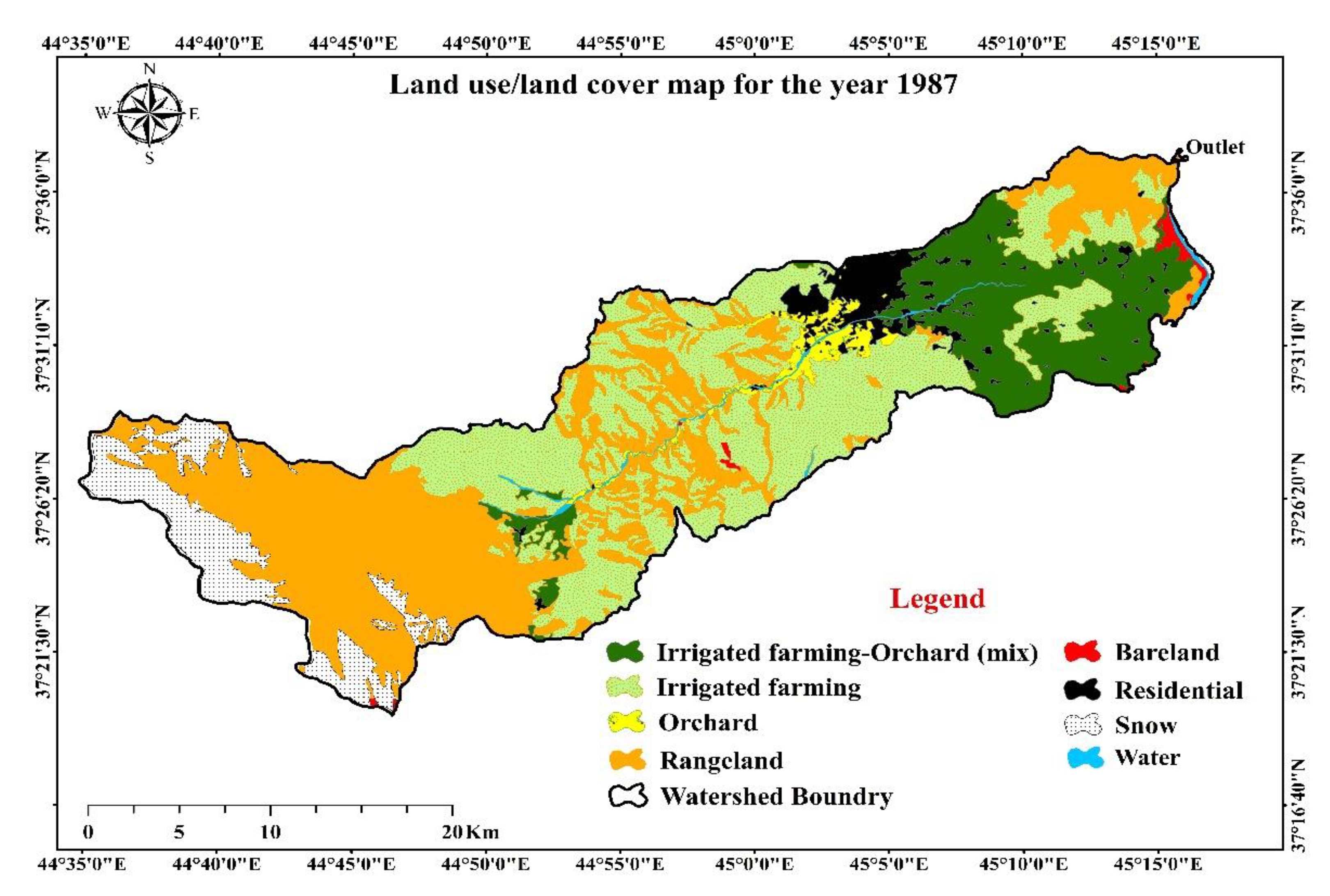
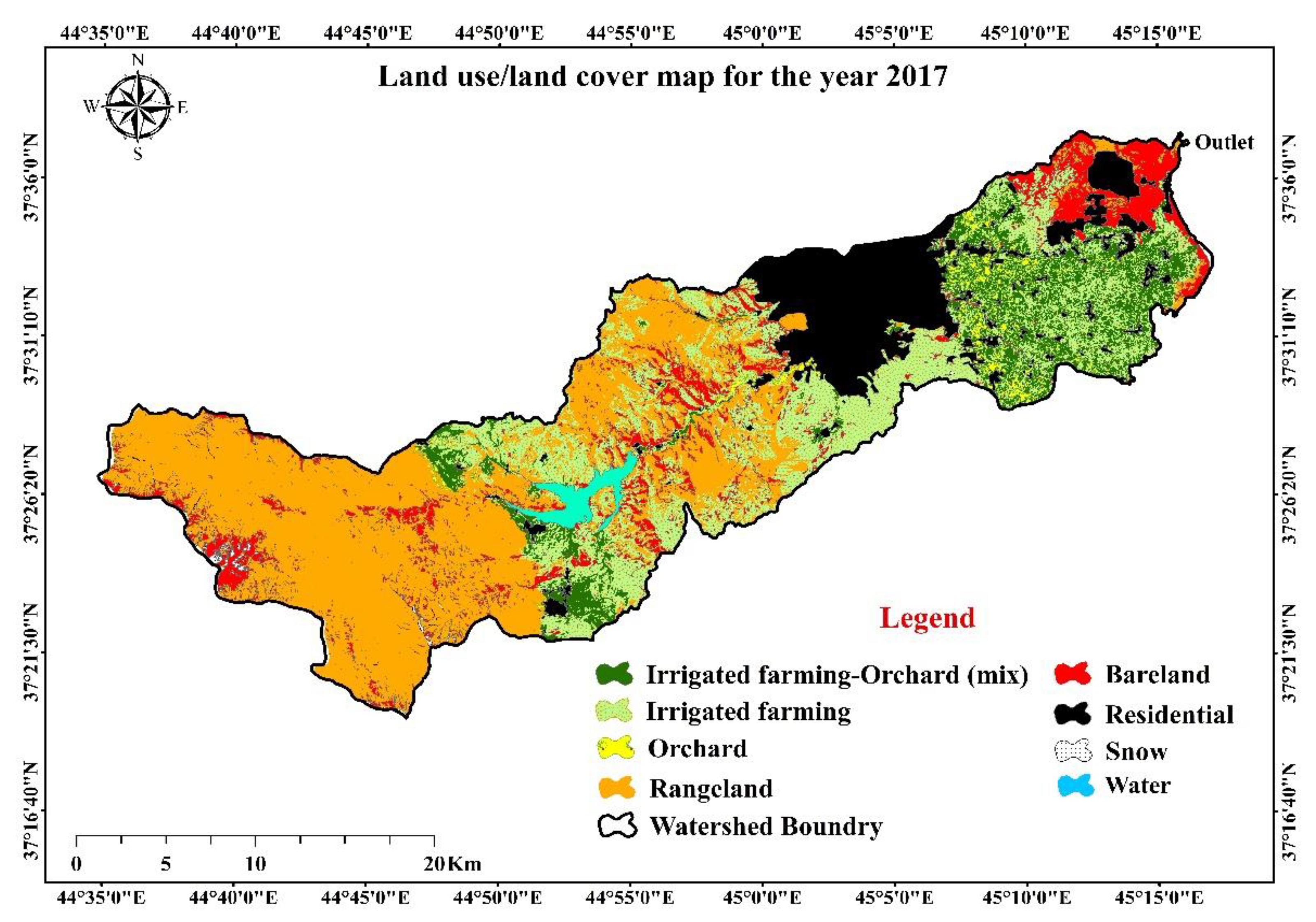
Land use/land cover maps obtained from the Iran Space Agency are presented in Figure 3 which depict a significant decrease in permanent snow cover in the upstream areas of the Shahrchai Dam in Urmia in 2017 (257 ha) compared to 1987 (5598 ha), with a decrease of approximately 5341 ha (95%).
Table 1 shows the amount of changes in land use categories for the years 1987 and 2017 in the Shahrchai–Urmia watershed.
Table 2 also showed a considerable change in the extent of bare land and snow cover. Bare land expanded remarkably, increasing from a mere 29.7 km2 (0.1%) in 1987 to 3654.2 km2 (11.5%) in 2017. In contrast, snow cover showed a significant reduction from 5598.1 km2 (17.6%) in 1987 to just 256.8 km2 (0.8%) in 2017, indicating a possible shift in climate or hydrological patterns in the region over the 30-year period. Furthermore, the residential and water body areas both expanded over the studied period. Residential areas increased from 55.7 km2 (0.2%) to 308.5 km2 (1.0%), reflecting urbanization. Water bodies also increased, rising from 112.3 km2 (0.4%) in 1987 to 866.8 km2 (2.7%) in 2017.
The IHA evaluates several parameters to assess threshold flows. The evaluation of the second group of parameters indicates that all parameters associated with minimum and maximum flows in the period before the construction of the Shahrchai Dam are higher than the period after its construction. Based on the results obtained from Table 1, it can be inferred that the impact of the Shahrchai Dam on minimum flows is more significant than its impact on maximum flows. Therefore, it is crucial to note that even slight deviations in minimum flows from the natural regime can have more significant effects on the ecosystem of the Shahrchai River than deviations in maximum flows [45].
Furthermore, the results demonstrate that there were no zero flow days observed in the Urmia Band hydrometric station before and after the construction of the dam. Similarly, after the construction of the cascade dams upstream of the Three Gorges Dam in China (Ali et al., [8] and the Golestan and Voshmgir dams (Daechini et al.) [46], no change has been reported in the number of zero flow days. However, the base flow, which is considered an influential factor on river hydrology, has decreased after the construction of the Shahrchai Dam.
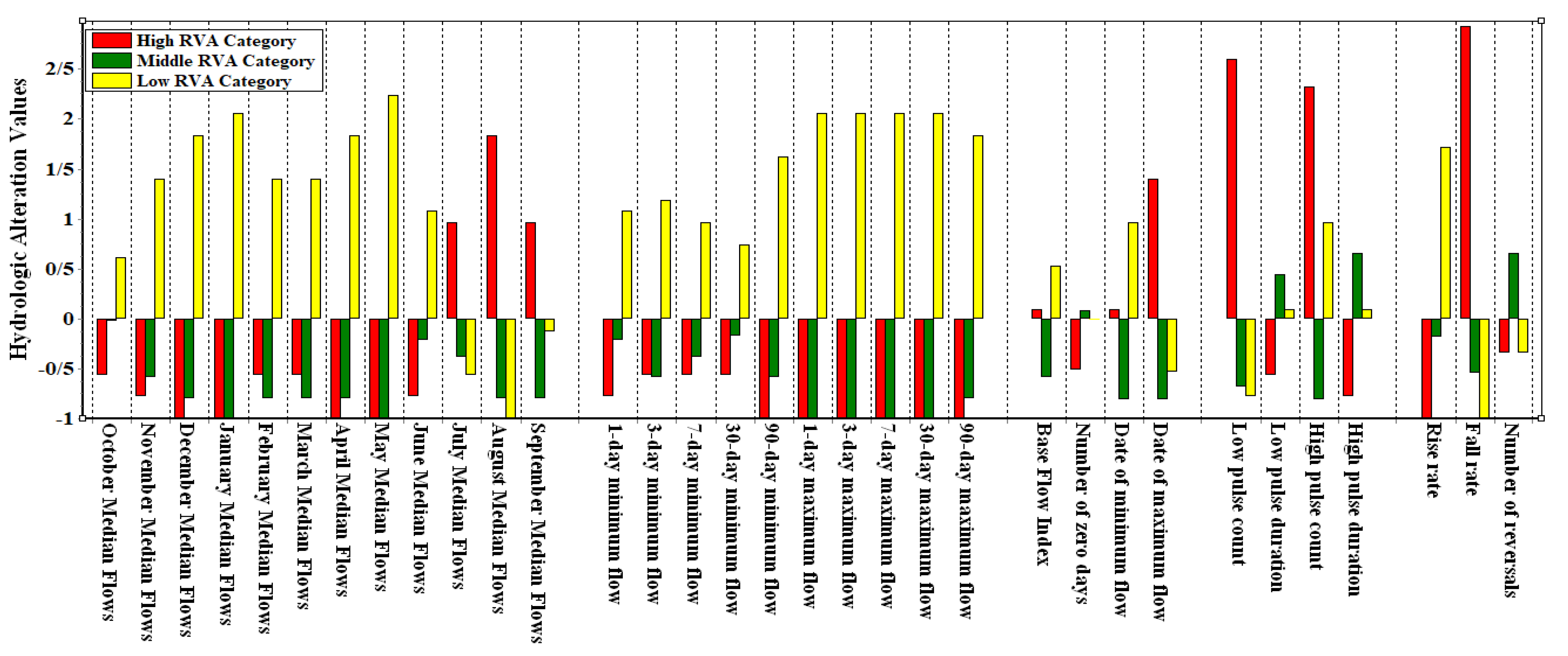
Figure 4 illustrates the degree of variation in thirty-three IHA parameters across three RVA target classes at the Urmia Band hydrometric station.
The evaluation of the range of variability approach (RVA) for the Urmia Band hydrometric station (Figure 4) reveals negative hydrological changes in the annual minimum and maximum flows, with a higher frequency of values in the average to high RVA. Conversely, positive hydrological changes in these parameters show a lower frequency of values in the RVA. The third group of IHA parameters provides information on the timing of annual threshold flows, including the timing of the annual minimum and maximum flows. Both parameters are crucial as they provide important information about environmental disturbances and streamflow shortages in aquatic ecosystems.
The analysis of the third group of parameters indicates that the number of days with minimum flow before and after the construction of the Shahrchai Dam was 262 and 290 days, respectively. Additionally, the number of days with maximum flow at the Urmia Band station was 117 days before the construction of the dam, but this increased to 181 days after the construction of the dam. These changes reflect the impact of the dam operations in the region. Therefore, the results of this study suggest that the construction of the Shahrchai Dam has led to changes in the hydrology of the Shahrchai River, which can have significant ecological and environmental consequences.
The fourth group of IHA parameters classifies low and high flow pulses based on their duration and frequency. This group provides information on the occurrence of high and low flow durations in a given year, defined by the 75th percentile for high flow and the 25th percentile for low flow before the change. The analysis of these parameters showed that after the construction of the dam, there was an increase of 83% in the number of low flow pulses, 18% in the duration of low flow pulses, and 150% in the number of high flow pulses. However, the duration of high flow pulses decreased by about 10% after the dam construction. These findings suggest that the construction of the Shahrchai Dam has had a significant impact on the hydrology of the Shahrchai River. The increase in low flow pulses and the decrease in high flow pulse duration can have a range of ecological and environmental implications, such as changes in the water quality, aquatic habitat, and riparian vegetation.
The fifth group of IHA parameters provides information on the magnitude of the increasing and decreasing fluctuations of flow and the number of hydraulic reversals, which indicate sudden changes in annual flow. The results from the Urmia Band station show a 26% increase in the magnitude of increasing flow fluctuations, a 47% increase in the magnitude of decreasing flow fluctuations, and a 4% decrease in the number of hydraulic reversals after the dam construction.
These findings suggest that the construction of the Shahrchai Dam has led to changes in the flow regime of the Shahrchai River, which can have significant ecological and environmental consequences. The increase in the magnitude of flow fluctuations and the decrease in hydraulic reversals can affect the aquatic habitat, riparian vegetation, and water quality.
The analysis of hydrological changes under the effects of the Shahrchai Dam at the study area shows considerable flow regime alterations, with some unique patterns compared to previous research. While Yang et al. [17] reported a 56% alteration downstream of Yellow River dams, the Shahrchai River showed an 83% increase in low flow pulses and a 150% increase in high flow pulses, indicating a more considerable impact. Contrasting Kumar et al. [25], who observed a broad range of flow alterations in the Penganga River, the Shahrchai Dam’s effects were predominantly marked in increasing flow variations. Additionally, while Khoeun et al. [27] emphasized intensifications in low flow amounts, the Shahrchai Dam uniquely caused a 10% decrease in the duration of high flow pulses, presenting new understandings of the interaction between low and high flow pulses.
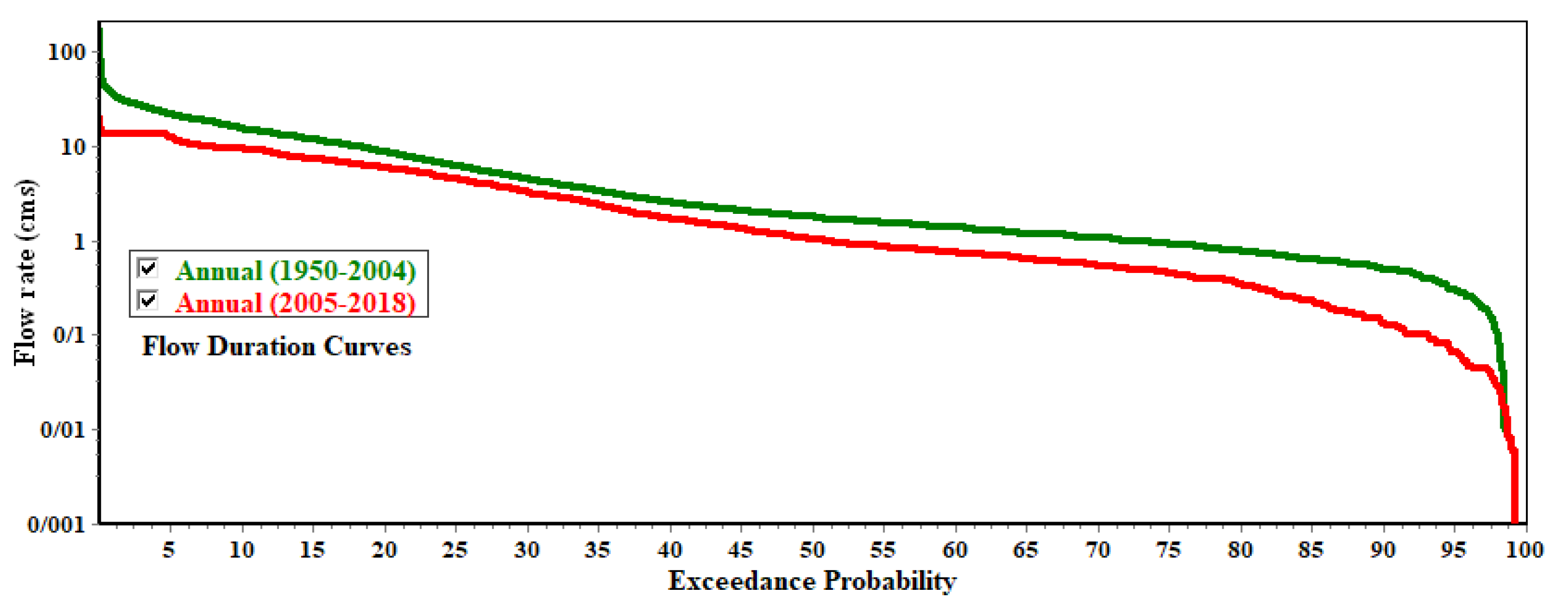
The flow duration curve related to flow data in two periods before and after is shown in Figure 5. Based on the information in Figure 5, it can be said that the discharge values in different excess probabilities have decreased in the period after the construction of the dam. It should be mentioned that the purpose of the studied dam is to supply drinking water, which causes the flow rate to drop in all the different excess probability percentages.

4. Discussion

The analysis of rainfall during the statistical period of 1984–2013 in the Shahrchai watershed showed no significant increase or decrease in precipitation [47]. Hence, it can be concluded that the amount of precipitation did not significantly contribute to the reduction in the flow rate of the Shahrchai River. The variability in precipitation form is one of the main factors leading to the reduction in the flow rate of the Shahrchai River. The reduction in water volume after the Shahrchai Dam construction can be attributed to the transfer of water from the dam, which amounts to approximately 76 million cubic meters per year for drinking and industrial purposes. Moreover, the flow rate of the Shahrchai River is dependent on snow cover and temperature [48].
According to LULC analysis during the study period, the LULC change contributing to the reduction in the flow rate of the Shahrchai River is the decrease in permanent snow cover. Ahmadi et al. (2013) also identified a decrease in snow cover resulting from the increasing temperature trend as one of the main factors responsible for the reduction in the flow rate of the Shahrchai River. Additionally, the land use/land cover maps of the study area indicated that the area of irrigated agriculture and orchards in the upstream of the dam construction site was about 895 ha in 1987, increasing to approximately 1712 ha in 2017. Therefore, it can be inferred that the area of irrigated agriculture and orchards in the upstream of the Shahrchai Dam has increased by approximately 92% over the last 30 years. Moreover, the reduction in the flow rate of the Shahrchai River upstream of the dam can be attributed to the expansion of irrigated agriculture and orchards, resulting in an increase in surface and groundwater extraction. This, combined with the effects of water transfer for drinking and industrial purposes after the construction of the dam and the decrease in permanent snow cover upstream of the dam, is consistent with the findings of Hessari and Zeinalzadeh [49].
Furthermore, research has demonstrated that the month with the highest monthly flow rate before the construction of the Shahrchai Dam was May, while after the dam’s construction, it was July. Jahanbakhsh et al. [50] discovered that more than 93% of the snowpack in the watershed melts in May. Therefore, it can be inferred that the runoff resulting from snowmelt in May has the most significant share in the flow rate of the Shahrchai River. Based on the above explanations, it is expected that during the spring season, the stored water volume in the study dam is at its maximum level due to the melting of snowpacks in the upstream areas. Thus, a portion of the stored water volume from July onwards is released for various purposes, such as agriculture and providing water for Lake Urmia, which can contribute to the increase in the flow rate of the Shahrchai River during the summer season after the construction of the Shahrchai Dam.
The evaluation of the range of variability approach (RVA) for the Urmia Band hydrometric station (Figure 4) showed significant hydrological changes due to the construction of the Shahrchai Dam. The study reveals negative changes in annual minimum and maximum flows, with a higher frequency of values in the average to high RVA, while positive changes show a lower frequency. The timing of these flow alterations is crucial as they indicate environmental disturbances and potential streamflow shortages in aquatic ecosystems. This finding aligns with Zuo and Liang [1], who emphasize the importance of the IHA method in evaluating flow characteristics before and after alterations. The third group of IHA parameters further elucidates the timing of annual threshold flows, providing valuable information about environmental disturbances.
The analysis shows that after the Shahrchai Dam’s construction, the number of days with minimum flow increased from 262 to 290, and the maximum flow days rose from 117 to 181. These changes indicate significant alterations in the river’s hydrology, impacting the ecosystem. Koel and Sparks [23] emphasize that the IHA method is valuable for maintaining water levels essential for aquatic life, and this study supports their assertion by demonstrating the dam’s impact on flow regimes. Additionally, the study’s results align with those of Kumar and Jayakumar [31], who found that human activities, such as dam construction, significantly alter river hydrology, leading to ecological consequences.
The fourth and fifth groups of the IHA parameters provide insights into low and high flow pulses and the magnitude of flow fluctuations. After the dam’s construction, low flow pulses increased by 83% and high flow pulses by 150%, while the duration of high flow pulses decreased by 10%. These changes can impact water quality, aquatic habitats, and riparian vegetation, as suggested by Ali et al. [8] in their study of the Yangtze River. Furthermore, the magnitude of increasing and decreasing flow fluctuations rose by 26% and 47%, respectively, with a 4% decrease in hydraulic reversals. These findings resonate with Mezger et al. [33], who observed significant changes in flow magnitude and timing after dam construction in Spanish rivers. Overall, the study underscores the profound impact of dam operations on the Shahrchai River’s hydrology and its ecological and environmental implications.

5. Conclusions

This study assesses the impact of the Shahrchai Dam construction on the flow regime of the Shahrchai River at the Band-e-Urmia hydrometric station from 1950 to 2017, considering the effects of land use/cover changes and investigating climatic variables. The evaluation was conducted in two periods, with the first period analyzing flow patterns before the dam construction (1950–2005) and the second period evaluating changes in hydrological indices after the dam construction from 2005 to 2017. The study’s findings demonstrate that the construction of the dam had a significant impact on the flow patterns of the Shahrchai River. The analysis of the monthly mean flow after the dam construction revealed the highest increase in flow in August (264%) and the highest decrease in flow in April (88%). Furthermore, the parameters related to the minimum and maximum flows, base flow, and duration of high flow pulses all decreased following the dam’s construction. However, the number of low flow pulses, duration of low flow pulses, and number of high flow pulses showed an increasing trend after the dam construction. The uniqueness of this research is in the analysis of hydrological changes in a dam with a storage regulatory function using the IHA approach. In this research, a significant increase of 83% in low flow pulses and a 150% increase in high flow pulses was observed, which is more considerable compared to other rivers. Additionally, a 10% reduction in the duration of high current pulses was uniquely identified in this study. These findings emphasize the significant and distinct effect of the Shahrchai Dam on the river flow regime and can help in flow management. The results have shown that, in addition to dam construction, other factors such as land use/cover changes and climate change have contributed to changes in hydrological indices. The analysis of land use/cover changes upstream of the dam revealed a significant increase in irrigated agricultural and orchard lands over the 30-year period, which can contribute to a reduction in river flow volume due to increased water withdrawal from surface and groundwater sources. Moreover, the analysis of climate factors revealed that, although there was no significant change in the amount of precipitation in the region, temperature increase and a shift in precipitation from snow to rain are important factors that affect the hydrological indices and river flow volume of the Shahrchai River. Therefore, the results of this study can serve as a useful tool for monitoring and developing compatibility criteria to reduce the negative effects of the Shahrchai Dam. Similar studies can be conducted in the future, using similar time intervals for periods before and after the impact when data become available. Additionally, future research should focus on evaluating the separate effects of human and climate factors on changes in the hydrological indices of river flow [51].
The significant impact of the Shahrchai Dam on the flow patterns of the Shahrchai River has implications for water management practices in the region. The observed changes in hydrological indices following the dam’s construction highlight the importance of considering both human activities and climate change when managing water resources. Maintaining environmental flow in urban rivers is critical for supporting the ecosystem services provided by rivers, such as water supply, flood control, and habitats for aquatic species, and requires comprehensive strategies that prioritize environmental protection and community engagement. Future research should explore the effectiveness of different environmental flow regimes in sustaining river ecosystems and mitigating the negative effects of dam construction and other human activities. Moreover, studies should investigate the potential of climate change adaptation strategies, such as water storage and conservation, to maintain the long-term sustainability of river systems in the face of changing climate conditions.

Author Contributions

Conceptualization, R.M., M.Z.S. and J.A.M.; methodology, R.M., M.Z.S. and J.A.M.; software, R.M., M.Z.S. and B.M.; validation, R.M., M.Z.S. and J.A.M.; resources, R.M. and M.Z.S.; data curation, M.Z.S.; writing—original draft preparation, M.Z.S.; writing—review and editing, R.M., M.Z.S., J.A.M. and B.M.; visualization, M.Z.S. and B.M.; supervision, R.M.; project administration, R.M. All authors have read and agreed to the published version of the manuscript.

Funding

This research received no external funding.

Data Availability Statement

All data generated or analyzed during this study are included in this published article.

Acknowledgments

We would like to express our sincere gratitude to the University of Mohaghegh Ardabili for the logistical supports who significantly contributed during the research works.

Conflicts of Interest

The authors declare no conflicts of interest.

References

  1. Zou, Q.; Liang, S.H. Effects of dams on river flow regime based on IHA/RVA. In Remote Sensing and GIS for Hydrology and Water Resources; IAHS Publications: Wallingford, UK, 2015; Volume 368, pp. 1–6. [Google Scholar]
  2. Naderi, M.; Sheikh, V.; Bahrehmand, A.; Komaki, C.B.; Ghangermeh, A. Analysis of river flow regime changes using the indicators of hydrologic alteration (Case study: Hableroud watershed). Water Soil. Manag. Model. 2023, 3, 1–19. [Google Scholar]
  3. Richter, B.D.; Postel, S.; Revenga, C.; Scudder, T.; Lehner, B.; Churchill, A.; Chow, M. Lost in development’s shadow: The downstream human consequences of dams. Water Altern. 2010, 3, 14. [Google Scholar]
  4. Fazel, N.; Haghighi, A.T.; Kløve, B. Analysis of land use and climate change impacts by comparing river flow records for headwaters and lowland reaches. Glob. Planet. Chang. 2017, 158, 47–56. [Google Scholar] [CrossRef]
  5. Kuriqi, A.; Ardiçlioǧlu, M. Investigation of hydraulic regime at middle part of the Loire River in context of floods and low flow events. Pollack Period. 2018, 13, 145–156. [Google Scholar] [CrossRef]
  6. Pokhrel, Y.; Burbano, M.; Roush, J.; Kang, H.; Sridhar, V.; Hyndman, D. A Review of the Integrated Effects of Changing Climate, Land Use, and Dams on Mekong River Hydrology. Water 2018, 10, 266. [Google Scholar] [CrossRef]
  7. Amini, H.; Esmali-Ouri, A.; Mostafazadeh, R.; Sharari, M.; Zabihi, M. Hydrological drought response of regulated river flow under the influence of dam reservoir in Ardabil Province. Earth Space Phys. 2019, 45, 1–15. [Google Scholar]
  8. Ali, R.; Kuriqi, A.; Abubaker, S.; Kisi, O. Hydrologic alteration at the upper and middle part of the Yangtze-river, China: Towards sustainable water resource management under increasing water exploitation. Sustainability 2019, 11, 5176. [Google Scholar] [CrossRef]
  9. Aguiar, F.C.; Martins, M.J.; Silva, P.C.; Fernandes, M.R. Riverscapes downstream of hydropower dams: Effects of altered flows and historical land-use change. Landsc. Urban. Plan. 2016, 153, 83–98. [Google Scholar] [CrossRef]
  10. Petts, G.E. Instream flow science for sustainable river management 1. JAWRA J. Am. Water Resour. Assoc. 2009, 45, 1071–1086. [Google Scholar] [CrossRef]
  11. Hayes, D.S.; Brändle, J.M.; Seliger, C.; Zeiringer, B.; Ferreira, T.; Schmutz, S. Advancing towards functional environmental flows for temperate floodplain rivers. Sci. Total Environ. 2018, 633, 1089–1104. [Google Scholar] [CrossRef]
  12. Yang, Z.; Yan, Y.; Liu, Q. Assessment of the flow regime alterations in the Lower Yellow River, China. Ecol. Inform. 2012, 10, 56–64. [Google Scholar] [CrossRef]
  13. Ge, J.; Peng, W.; Huang, W.; Qu, X.; Singh, S.K. Quantitative assessment of flow regime alteration using a revised range of variability methods. Water 2018, 10, 597. [Google Scholar] [CrossRef]
  14. Olden, J.D.; Poff, N.L. Redundancy and the choice of hydrologic indices for characterizing streamflow regimes. River Res. Appl. 2003, 19, 101–121. [Google Scholar] [CrossRef]
  15. Song, X.; Zhuang, Y.; Wang, X.; Li, E. Combined effect of Danjiangkou Reservoir and cascade reservoirs on hydrologic regime downstream. J. Hydrol. Eng. 2018, 23, 05018008. [Google Scholar] [CrossRef]
  16. Vu, T.T.; Kiesel, J.; Guse, B.; Fohrer, N. Towards an improved understanding of hydrological change–linking hydrologic metrics and multiple change point tests. J. Water Clim. Chang. 2019, 10, 743–758. [Google Scholar] [CrossRef]
  17. Yang, T.; Zhang, Q.; Chen, Y.D.; Tao, X.; Xu, C.Y.; Chen, X. A spatial assessment of hydrologic alteration caused by dam construction in the middle and lower Yellow River, China. Hydrol. Process. An. Int. J. 2008, 22, 3829–3843. [Google Scholar] [CrossRef]
  18. Linnansaari, T.; Monk, W.A.; Baird, D.J.; Curry, R.A. Review of approaches and methods to assess Environmental Flows across Canada and internationally. DFO Can. Sci. Advis. Sec. Res. Doc. 2012, 39, 74. [Google Scholar]
  19. Richter, B.D.; Baumgartner, J.V.; Powell, J.; Braun, D.P. A method for assessing hydrologic alteration within ecosystems. Conserv. Biol. 1996, 10, 1163–1174. [Google Scholar] [CrossRef]
  20. Gao, Y.; Vogel, R.M.; Kroll, C.N.; Poff, N.L.; Olden, J.D. Development of representative indicators of hydrologic alteration. J. Hydrol. 2009, 374, 136–147. [Google Scholar] [CrossRef]
  21. Yu, Y.; Wang, C.; Wang, P.; Hou, J.; Qian, J. Assessment of multi-objective reservoir operation in the middle and lower Yangtze River based on a flow regime influenced by the Three Gorges Project. Ecol. Inform. 2017, 38, 115–125. [Google Scholar] [CrossRef]
  22. Kuriqi, A.; Pinheiro, A.N.; Sordo-Ward, A.; Garrote, L. Influence of hydrologically based environmental flow methods on flow alteration and energy production in a run-of-river hydropower plant. J. Clean. Prod. 2019, 232, 1028–1042. [Google Scholar] [CrossRef]
  23. Koel, T.M.; Sparks, R.E. Historical patterns of river stage and fish communities as criteria for operations of dams on the Illinois River. River Res. Appl. 2002, 18, 3–19. [Google Scholar] [CrossRef]
  24. Shiau, J.T.; Wu, F.C. Feasible diversion and instream flow release using range of variability approach. J. Water Resour. Plan. Manag. 2004, 130, 395–404. [Google Scholar] [CrossRef]
  25. Kumar, A.; Tripathi, V.K.; Kumar, P.; Rakshit, A. Assessment of hydrologic impact on flow regime due to dam inception using IHA framework. Environ. Sci. Pollut. Res. 2023, 30, 37821–37844. [Google Scholar] [CrossRef] [PubMed]
  26. Fang, G.; Yan, M.; Dai, L.; Huang, X.; Zhang, X.; Lu, Y. Improved indicators of hydrological alteration for quantifying the dam-induced impacts on flow regimes in small and medium-sized rivers. Sci. Total Environ. 2023, 867, 161499. [Google Scholar] [CrossRef]
  27. Khoeun, R.; Sor, R.; Chann, K.; Phy, S.R.; Oeurng, C.; Sok, T. The Impacts of Dams on Streamflow in Tributaries to the Lower Mekong Basin. Sustainability 2024, 16, 6700. [Google Scholar] [CrossRef]
  28. Legleiter, C.J. Downstream effects of recent reservoir development on the morphodynamics of a meandering channel: Savery Creek, Wyoming, USA. River Res. Appl. 2015, 31, 1328–1343. [Google Scholar] [CrossRef]
  29. Li, D.; Long, D.; Zhao, J.; Lu, H.; Hong, Y. Observed changes in flow regimes in the Mekong River basin. J. Hydrol. 2017, 551, 217–232. [Google Scholar] [CrossRef]
  30. López-Ballesteros, A.; Senent-Aparicio, J.; Martínez, C.; Pérez-Sánchez, J. Assessment of future hydrologic alteration due to climate change in the Aracthos River basin (NW Greece). Sci. Total Environ. 2020, 733, 139299. [Google Scholar] [CrossRef]
  31. Kumar, A.U.; Jayakumar, K.V. Hydrological alterations due to anthropogenic activities in Krishna River Basin, India. Ecol. Indic. 2020, 108, 105663. [Google Scholar] [CrossRef]
  32. Song, X.; Zhuang, Y.; Wang, X.; Li, E.; Zhang, Y.; Lu, X.; Liu, X. Analysis of hydrologic regime changes caused by dams in China. J. Hydrol. Eng. 2020, 25, 05020003. [Google Scholar] [CrossRef]
  33. Mezger, G.; del Tánago, M.G.; De Stefano, L. Environmental flows and the mitigation of hydrological alteration downstream from dams: The Spanish case. J. Hydrol. 2021, 598, 125732. [Google Scholar] [CrossRef]
  34. Islam, A.R.M.T.; Talukdar, S.; Akhter, S.; Eibek, K.U.; Rahman, M.M.; Pal, S.; Mosavi, A. Assessing the impact of the Farakka Barrage on hydrological alteration in the Padma River with future insight. Sustainability 2022, 14, 5233. [Google Scholar] [CrossRef]
  35. Akula, U.K.; Jayakumar, K.V. Assessment of flow regime alteration in the Krishna River basin. ISH J. Hydraul. Eng. 2022, 28, 212–218. [Google Scholar]
  36. Panditharathne, R.; Gunathilake, M.B.; Chathuranika, I.M.; Rathnayake, U.; Babel, M.S.; Jha, M.K. Trends and Variabilities in Rainfall and Streamflow: A Case Study of the Nilwala River Basin in Sri Lanka. Hydrology 2023, 10, 8. [Google Scholar] [CrossRef]
  37. Malede, D.A.; Alamirew, T.; Andualem, T.G. Integrated and Individual Impacts of Land Use Land Cover and Climate Changes on Hydrological Flows over Birr River Watershed, Abbay Basin, Ethiopia. Water 2023, 15, 166. [Google Scholar] [CrossRef]
  38. Nasiri Khiazvi, A.; Mostafazadeh, R.; Esmali Ouri, A.; Ghafarzadeh, O.; Golshan, M. Alteration of hydrologic flow indicators in Ardabil Balikhlouchai River under combined effects of change in climatic variables and Yamchi Dam construction using Range of Variability Approach. Watershed Eng. Manag. 2019, 11, 851–865. (In Persian) [Google Scholar]
  39. Esfandyari Darabad, F.; Mostafazadeh, R.; Shahmoradi, R.; Nasiri Khiavi, A. The Analysis of the changes of the hydrological flow indices affected by dam construction in Zarrinehrood and Saruqchai rivers of West Azerbaijan Province. Hydrogeomorphology 2019, 6, 57–77. [Google Scholar]
  40. Morid, R.; Igderi, S.; Delavar, M. Assessment of Climate Change Impacts on Aquatic Habitat Suitability in Kordan River Case Study: Oxynemacheilus bergianus. Iran-Water Resour. Res. 2016, 11, 145–158. [Google Scholar]
  41. Gómez-Balandra, M.A.; del Pilar Saldaña-Fabela, M.; Martínez-Jiménez, M. The Nature Conservancy. Indicators of Hydrologic Alteration Version 7.1 User’s Manual; The Nature Conservancy: Charlottesville, VA, USA, 2009; p. 81. Available online: https://www.conservationgateway.org (accessed on 19 October 2022).
  42. Mathews, R.; Richter, B.D. Application of the Indicators of hydrologic alteration software in environmental flow setting 1. JAWRA J. Am. Water Resour. Assoc. 2007, 43, 1400–1413. [Google Scholar] [CrossRef]
  43. Richter, B.D.; Baumgartner, J.V.; Braun, D.P.; Powell, J. A spatial assessment of hydrologic alteration within a river network. Regul. Rivers: Res. Manag. An. Int. J. Devoted River Res. Manag. 1998, 14, 329–340. [Google Scholar] [CrossRef]
  44. Baubekova, A.; Akbari, M.; Etemadi, H.; Ashraf, F.B.; Hekmatzadeh, A.; Haghighi, A.T. Causes effects of upstream-downstream flow regime alteration over Catchment-Estuary-Coastal systems. Sci. Total Environ. 2023, 858, 160045. [Google Scholar] [CrossRef] [PubMed]
  45. Richter, B.; Baumgartner, J.; Wigington, R.; Braun, D. How much water does a river need? Freshw. Biol. 1997, 37, 231–249. [Google Scholar] [CrossRef]
  46. Daechini, F.; Vafakhah, M.; Moosavi, V. Impacts of Dam Construction on Indicators of Hydrologic Alterations in the Gorganroud Watershed. Ecohydrology 2022, 9, 185–198. (In Persian) [Google Scholar]
  47. Nazeri Tahrudi, M.; Ahmadi, F.; Khalili, K. Evaluation the Trend and Trend Chang Point of Urmia Lake Basin Precipitation. Water Soil. 2017, 31, 644–659. (In Persian) [Google Scholar]
  48. Ahmadi, F.; Khalili, K.; Behmanesh, J.; Verdinazhad, V. Determination of Climate Changes on Air Temperature and Shahar-Chai River in the West of Urmia Lake Using Trend and Stationarity Analysis. Irrig. Sci. Eng. 2013, 35, 97–108. (In Persian) [Google Scholar]
  49. Hessari, B.; Zeinalzadeh, K. Investigation on human activities effects on water resources trend of Urmia Plain. Watershed Eng. Manag. 2020, 12, 415–427. (In Persian) [Google Scholar]
  50. Jahanbakhsh, S.; din Pazhoh, Y.; Aalinejhad, M. Impacts of Climate Change on Runoff from Snowmelt (Case Study: Shahrchai basin Urmia). Geogr. Plan. 2019, 23, 91–107. (In Persian) [Google Scholar]
  51. Keivan Behjou, F.; Mostafazadeh, R.; Alaei, N. Effects of Forest Logging Systems on the River Flow Regime Indices Using Graphical Techniques: A Case Study in a Small Natural Forest. Hydrology 2024, 11, 94. [Google Scholar] [CrossRef]
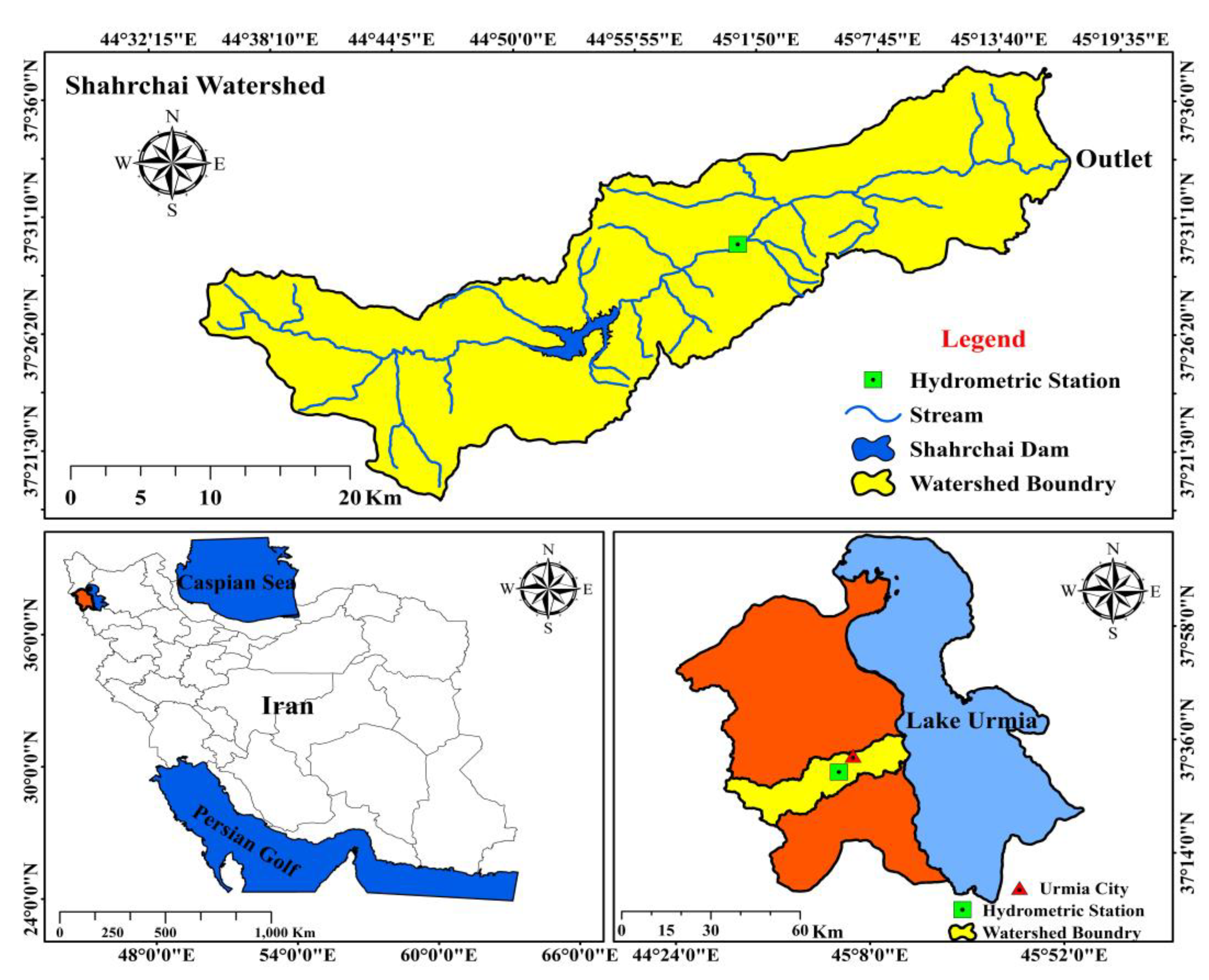
Figure 1. The location of the Urmia study area, Band hydrometery station, and Shahrchai Dam in Iran. Red area: Political boundary of Urmia city.
Earth 05 00023 g001
Figure 2. Monthly mean flow before and after the construction of the Shahrchai Dam.
Earth 05 00023 g002
Figure 3. Land use/land cover map for the years 1987 (top) and 2017 (bottom) for the Shahrchai–Urmia watershed.
Earth 05 00023 g003aEarth 05 00023 g003b
Figure 4. The degree of variation in 33 IHA parameters in 3 RVA target classes for the Urmia Band hydrometric station.
Earth 05 00023 g004
Figure 5. The flow duration curves of the river flow pre- and post-dam construction for the Urmia Band hydrometric station.
Earth 05 00023 g005
Table 1. Results of IHA parameter changes in RVA method for the Urmia Band Hydrometric Station on the Shahr-chai River.
Group/IHA ParameterPre-Impact Period
1950–2004 (55 years)
Post-Impact Period
2005–2018 (14 years)
RVA BoundariesRelative Chang (%)
MediansRange of ChangesMediansRange of ChangesLowHigh
MinimumMaximumMinimumMaximum
Group 1October0.800.254.400.640.065.560.621.20−19.8
November1.200.223.550.620.101.850.861.59−48.2
December1.200.224.040.400.021.120.991.46−67.1
January1.180.192.740.520.000.790.921.40−56.0
February1.530.535.590.640.1211.501.261.85−58.3
March4.001.1011.581.280.3813.803.055.33−68.0
April12.133.4029.521.490.1013.8010.7515.24−87.8
May18.504.2153.003.540.5113.8016.0023.71−80.9
June9.730.6929.505.400.6513.806.6011.90−44.5
July2.480.0011.006.140.4513.801.774.30147.6
August0.950.003.593.511.1613.800.731.18268.9
September0.600.006.601.450.0713.800.481.12142.2
Group 21-day minimum0.200.000.900.030.000.390.090.31−85.3
3-day minimum0.240.000.900.040.000.490.160.39−84.5
7-day minimum0.310.000.990.090.000.560.210.44−72.3
30-day minimum0.490.001.290.160.000.690.330.61−67.1
90-day minimum0.890.002.190.420.080.800.751.09−52.9
1-day maximum34.3810.00170.0012.107.6519.9029.5644.08−64.8
3-day maximum29.339.27103.1010.687.2615.3024.8535.20−63.6
7-day maximum25.168.8091.399.297.0813.8922.1731.08−63.1
30-day maximum20.776.4057.797.084.7113.8217.9224.85−65.9
90-day maximum14.795.0130.905.744.0513.8112.3217.78−61.2
Group 3Number of zero days0.000.0089.000.000.0037.000.000.00NA
Base flow index0.060.000.340.040.000.230.030.09−29.5
Date of minimum2621353290135825427710.7
Date of maximum1175432518158246105128.554.7
Group 4Low pulse count6115112233.48883.3
Low pulse duration5.511196.5261.53.2410.5218.2
High pulse count31107.511224150.0
High pulse duration511044.512362.7435.84−10.0
Group 5Rise rate0.230.0210.170.060.260.200.30−28.3
Fall rate−0.245−0.68−0.095−0.13−0.24−0.05−0.28−0.20−46.9
Number of reversals114511531102616699.48121.5−3.9
Table 2. Areas in different land use/landcover classes for studied years in the Shahrchai–Urmia watershed.
Land Use/Land Cover19872017
Km2%Km2%
Irrigated farming-Orchard (mix)820.12.61605.75.1
Irrigated Farming7344.023.24483.214.1
Orchard74.40.2106.10.3
Rangeland17,685.755.820,428.964.4
Bare land29.70.13654.211.5
Residential55.70.2308.51.0
Snow5598.117.6256.80.8
Water112.30.4866.82.7
Disclaimer/Publisher’s Note: The statements, opinions and data contained in all publications are solely those of the individual author(s) and contributor(s) and not of MDPI and/or the editor(s). MDPI and/or the editor(s) disclaim responsibility for any injury to people or property resulting from any ideas, methods, instructions or products referred to in the content.