Proceeding Paper

Beyond the Museum: Virtual and Physical Replicas of Pompeii’s Siege Marks †

by
Filippo Fantini
1 and
Silvia Bertacchi
2,*
1
Department of Architecture, Alma Mater Studiorum–Università di Bologna, 40136 Bologna, Italy
2
Department of Engineering, Università degli Studi della Campania Luigi Vanvitelli, 81031 Aversa, Italy
*
Author to whom correspondence should be addressed.
Presented at the Conference “Discovering Pompeii: From Effects to Causes—From Surveying to the Reconstructions of Ballistae and Scorpiones”, Aversa, Italy, 27 February 2025.
Eng. Proc. 2025, 96(1), 11; https://doi.org/10.3390/engproc2025096011
Published: 10 June 2025

Abstract

:
This study investigates the potential of reality-based 3D digital modeling, acquired for scientific purposes, to enhance the understanding and accessibility of ballistic imprints on Pompeii’s city walls. These impact marks, attributed to the Sullan siege of 89 BC, were caused by projectiles launched by Roman elastic torsion weapons. High-resolution models were acquired through integrated 3D survey techniques to create both virtual and physical replicas. These assets enhance museum accessibility, offering interactive digital content and tactile 3D-printed replicas for visually impaired and mobility-restricted visitors. The findings highlight the role of digital heritage in archaeological research, conservation, and public engagement, bridging the gap between academic study and inclusive cultural dissemination.

1. Introduction

The model, referred to as a maquette, is one of the most widespread and ancient forms of architectural representation [1]. Constructed with diverse materials and serving multiple purposes, the model functions as both a representation and a physical replica of the actual structure [2,3]. Historically, this representation fulfilled specific roles, including design prefiguration for clients and facilitating communication among workers during construction [4]. As such, the model encapsulated the fundamental design and architectural concepts in their most refined form [5] (pp. 131–163).
Today, the digital version of the model, like its physical counterpart, offers a wider range of applications, including but not limited to recording reality, whence the term “reality-based”, which signifies the creation of a replica that reliably adheres to real-world morphometric data. Especially in the Cultural Heritage domain, three-dimensional (3D) digitization has become an essential tool for recording and analyzing architectural and archaeological artifacts in a rapid, accurate, and efficient way. The obtained high-resolution reality-based models, primarily captured for the record of the geometric features and conservation state of physical artifacts, have also become increasingly pivotal to a vast range of analysis and are recommended as dynamic resources for restoration planning and management. Moreover, they have improved the dissemination strategies for public engagement, even for administration entities, making heritage more accessible to a wider audience and fostering the breaking down of physical and cognitive barriers to cultural assets. The latter aspect is becoming crucial as the potentialities of digital assets can effectively convey even complex concepts and enable interactive and tactile experiences [6], capable of developing an appropriate cognitive process both for conventional visitors as well as for those with reduced or even absent visual and/or mobility abilities. Reflecting on the use of digital models as tools to explore and support dissemination activities is part of a climate of increased sensitivity that institutions in charge of the preservation and dissemination of sites of cultural interest have embraced toward weaker categories, as evidenced by the recent revision of the visitor information plaques, made more inclusive, present in many museums or archaeological sites [7,8].
In this framework, this research aims to explore communication strategies that, starting from highly reliable 3D documentation acquired through active and passive sensing technologies for scientific and research purposes, can effectively convey to the widest and most diverse audience possible the initial results of the documentation of the ballistic imprints on the northern city walls of Pompeii (Figure 1), which archaeologists attribute to the Sullan siege in 89 BC [9,10,11]. This subject is little known [12,13] but of fundamental importance since it is one of the few existing cases, if not the only one, where it is possible to measure the firepower of elastic torsion weapons of Roman artillery of the 1st century BC from the still visible effect of the impact on stone ashlars, the final goal of the SCORPiò-NIDI project.

2. Materials and Methods

The research on ballistic imprints was carried out within the framework of the SCORPiò-NIDI project, of which the initial results on impact marks proved to be particularly significant [14,15]. These traces, caused by projectiles launched by the besieging forces, are distributed along the fortified section between Vesuvio Gate and Ercolano Gate, with higher concentrations near towers and access points (Figure 2). The difficulty in recognizing them stems from several aspects: (i) they are distributed seemingly at random and appear at different heights on the wall, including areas that are barely visible or inaccessible; (ii) the heterogeneous composition of the wall’s materials (varying by area and historical period, including pappamonte stone, tuff, Sarno limestone, or lava in opus incertum) complicates the identification of ballistic imprints without proper guidance in reading the archaeological context, as they can easily be mistaken for natural cavities in the stone ashlars; and (iii) seasonal weed vegetation growth, which can be more or less abundant depending on the time of year, further obscures their visibility.
Currently, the northern section of the walls is inaccessible to the public, pending the completion of the project to restore the pedestrian and bicycle paths and the logistics of visitor flows. As a result, the extensive outer section remains temporarily closed to visitors. In addition, the site’s topography presents further challenges: the terrain is partly steep and lacks accessible pathways in this area for individuals with reduced mobility. Thus, a twofold challenge emerges: on the one hand, an objective issue related to physical accessibility, and on the other, the difficulty of making the subject matter comprehensible and intelligible, even to experts. Addressing both issues requires the adoption of innovative strategies for the communication and enhancement of these historical traces. This involves not only an appropriate museological narrative [16] (pp. 28–37) but also tangible tactile supports capable of making the subject matter more accessible, particularly for users with limited mobility or visual impairments [17]. To achieve this, the research leverages high-resolution digital three-dimensional models captured for scientific documentation.

2.1. The 3D Assets

The available 3D models were acquired through an integrated approach, combining multiple techniques with customized pipelines, to achieve the following assets:
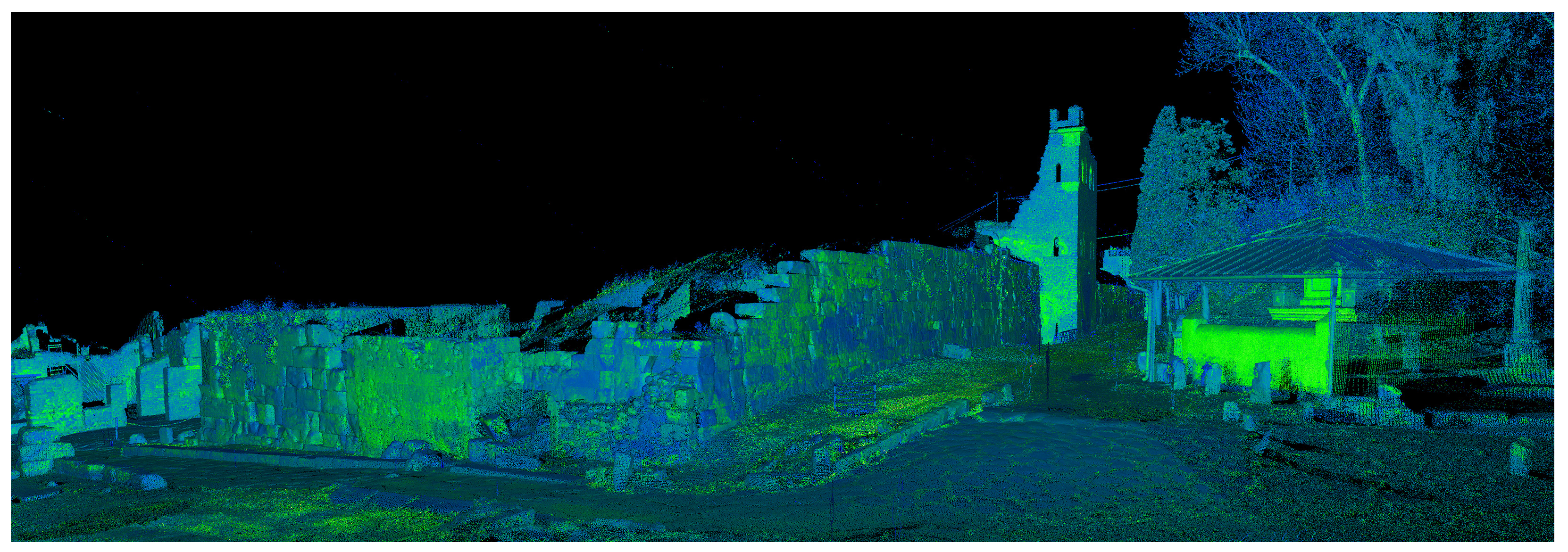
  • General documentation of the fortified section, extending approximately 300 m, was conducted using a time-of-flight (ToF) terrestrial laser scanner (TLS) device (Figure 3). This provided a spatial reference framework and facilitated the localization of impact marks, which were more recognizable in sections with regular ashlars;
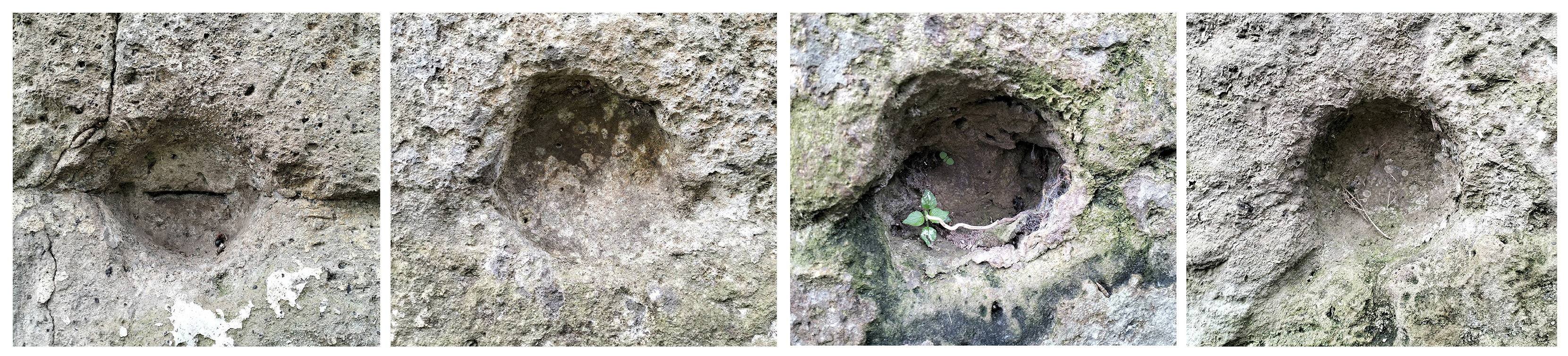
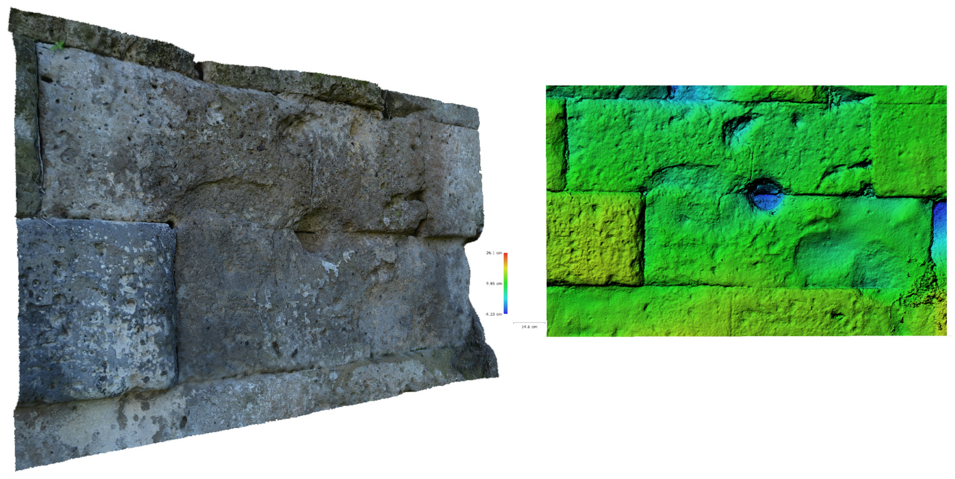
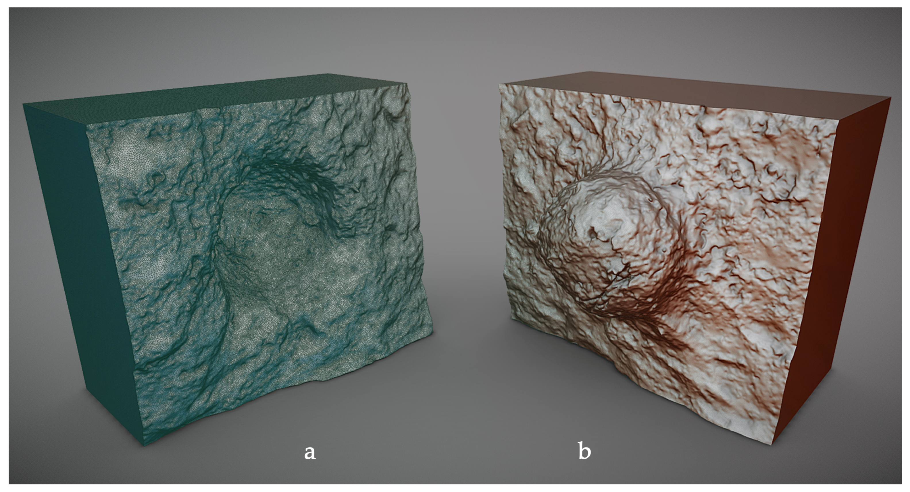
  • Detailed photogrammetric documentation was carried out using structure-from-motion (SfM) techniques (Figure 4). This focused on specific impact marks, including the deepest and widest ones, caused by stone balls of various diameters (up to 18 cm), as well as smaller traces possibly caused by metal-tipped arrows or lead sling bullets. The research also documented spheroidal stone projectiles still preserved in the museum.
The integration of multiple survey campaigns and the data processing resulted in high-resolution polygonal models complete with descriptive textures (Figure 5).

2.2. The Collection

Based on these 3D high-resolution models, the main purpose was to develop a series of exhibitable assets, enabling site conservators to provide non-expert audiences with effective storytelling tools about ancient siege and defense techniques. These assets serve both museological (scientific-narrative) and exhibitory (perceptual-display) purposes [18].
To this end, the collection includes four main categories of assets, three developed by the authors based on the surveyed data and one created by external experts:
  • Architectural Complex (AC)—A large-scale 3D model of the northern city walls, illustrating building materials, historical construction phases, and the location of case studies [19] (typological and structural aspects) (Figure 6);
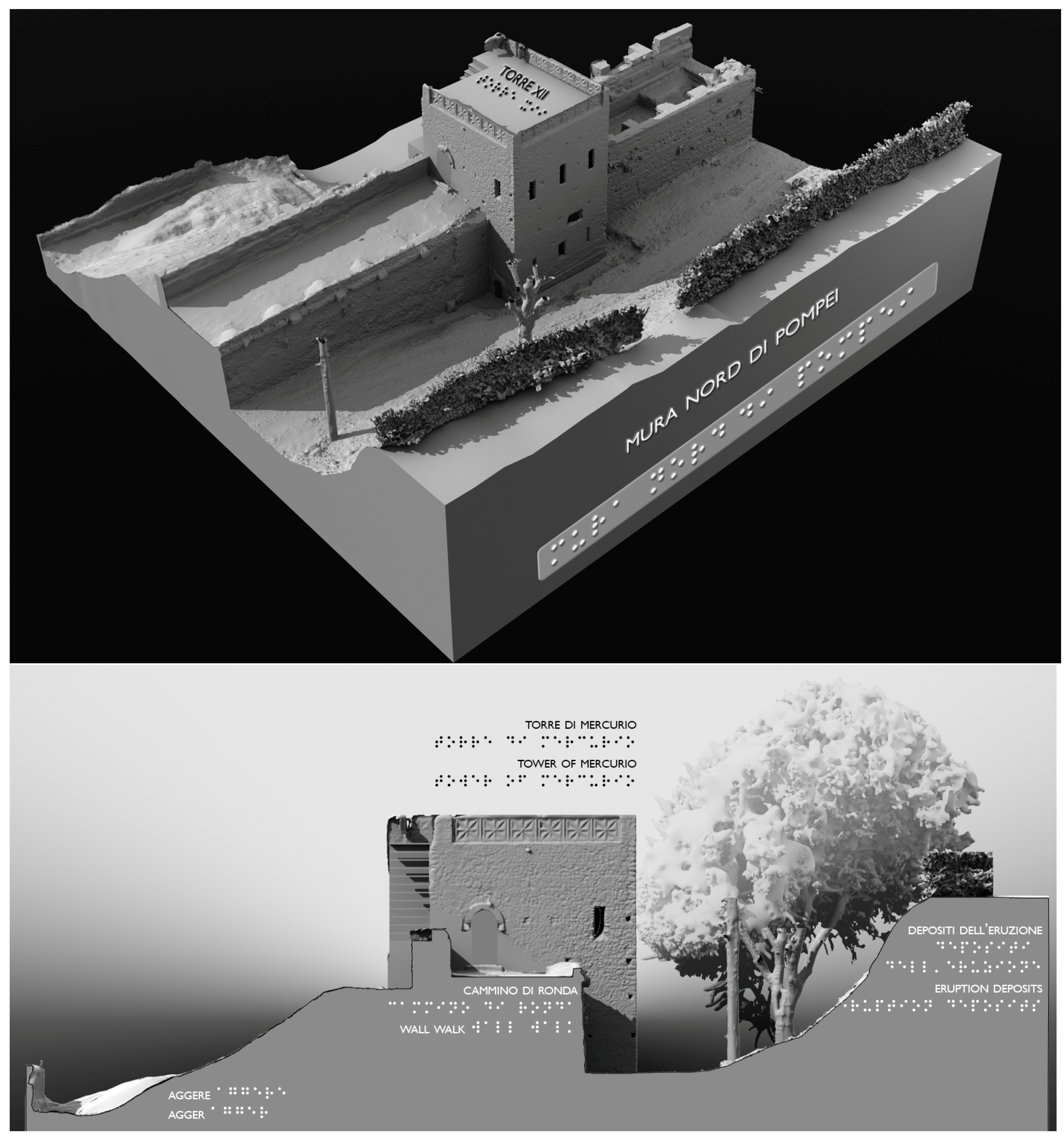
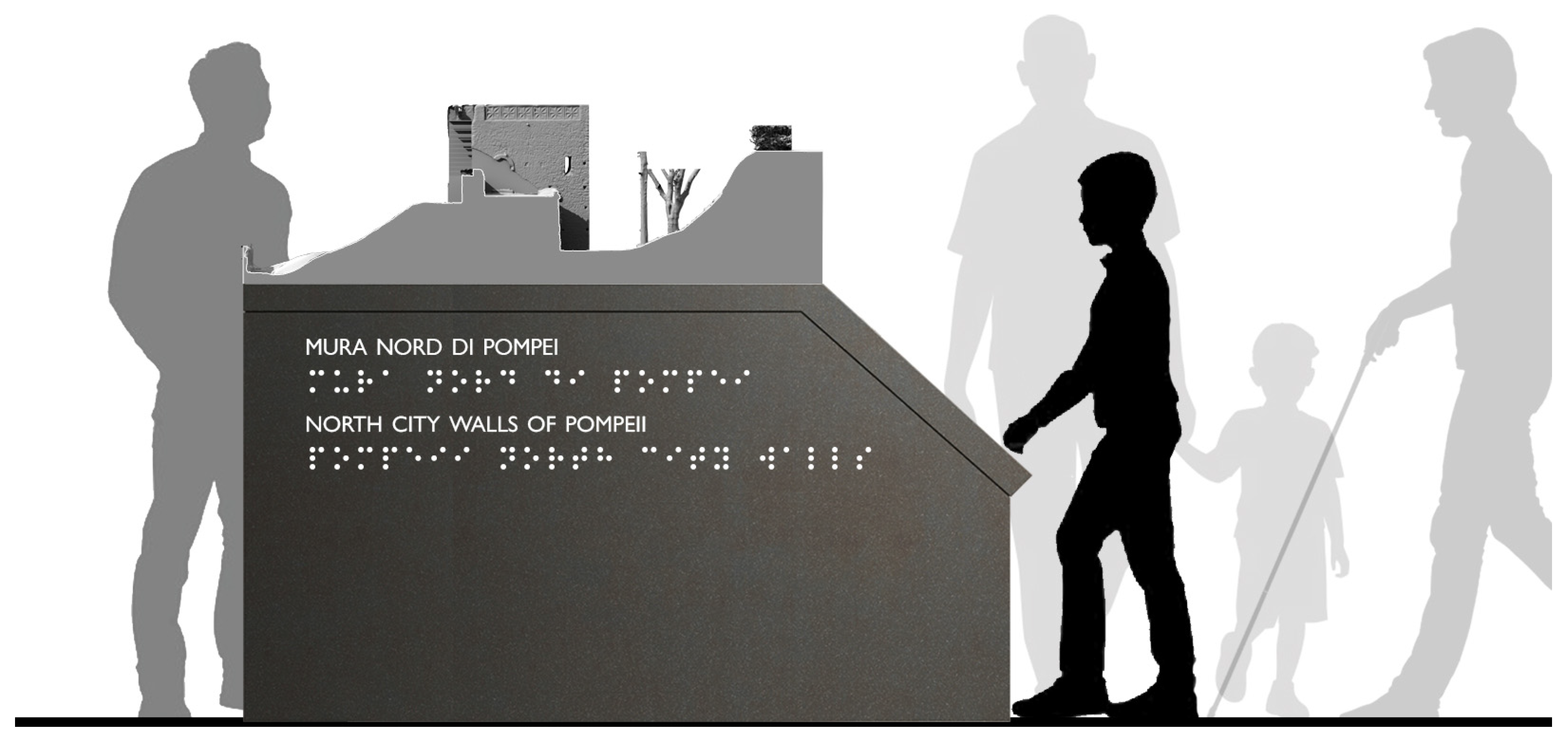
  • Architectural Section (AS)—A cutaway model of the city walls including a restored tower and the embankment behind the walls, explaining the spatial organization and proportions between all the elements (proportional aspect) (Figure 7);
  • Architectural Object (AO)—A detailed 3D model of individual case studies, including impact marks and projectiles, to compare the effects of impact on the walls with the blunt objects that caused them [20] (dimensional aspect) (Figure 8);
  • Siege Weapons (SW)—Replicas of ballistae and scorpions, commonly used to launch stone balls and metal-tipped darts, reconstructed at various scales using historical sources [21] (mechanical aspects) (Figure 9).
The developed assets include both virtual content and physical prototypes:
  • Virtual content: These digital assets offer high flexibility and can be used for multiple purposes, including professional applications, education, and research. Formats include renderings, orthoimages, simulations, animations, and more. To ensure the most accurate representation, textures have been calibrated to match the apparent color of the original surfaces.
  • 3D printed prototypes: Unlike virtual assets, physical replicas require a dedicated design phase to enhance readability and usability following appropriate requirements [22]. Various printing scales were chosen based on artifact type, including 1:100 for AC, 1:50 for AS, and 1:1 for AO.
Additionally, the functioning reconstruction of ancient Roman artillery (SW) was carried out by JustMO’, a cultural and creative enterprise. These reconstructions, produced using historically accurate materials, exist at both full scale and reduced scale for educational and experimental purposes.

3. Results

The integration of advanced survey techniques produced a comprehensive and high-resolution 3D dataset that accurately represents the ballistic traces on the northern walls.
The following list details the main steps taken to obtain the different outputs:
  • General and detailed digital acquisition phase—The survey approach included both a general measurement based on an active-sensor device due to the large extent of the surveyed area and a series of detailed photogrammetric acquisitions of specific case studies. The 45 medium-resolution TLS scans (10 mm at 10 m) were registered using the Leica Cyclone software (version 9) [23], generating a complete 374-million-point cloud. The photogrammetric survey was conducted with a Nikon D5300 Single-Lens Reflex Camera equipped with a Nikon AF-P 18–55mm f/3.5–5.6 DX VR lens, along with a white balance target to ensure color accuracy.
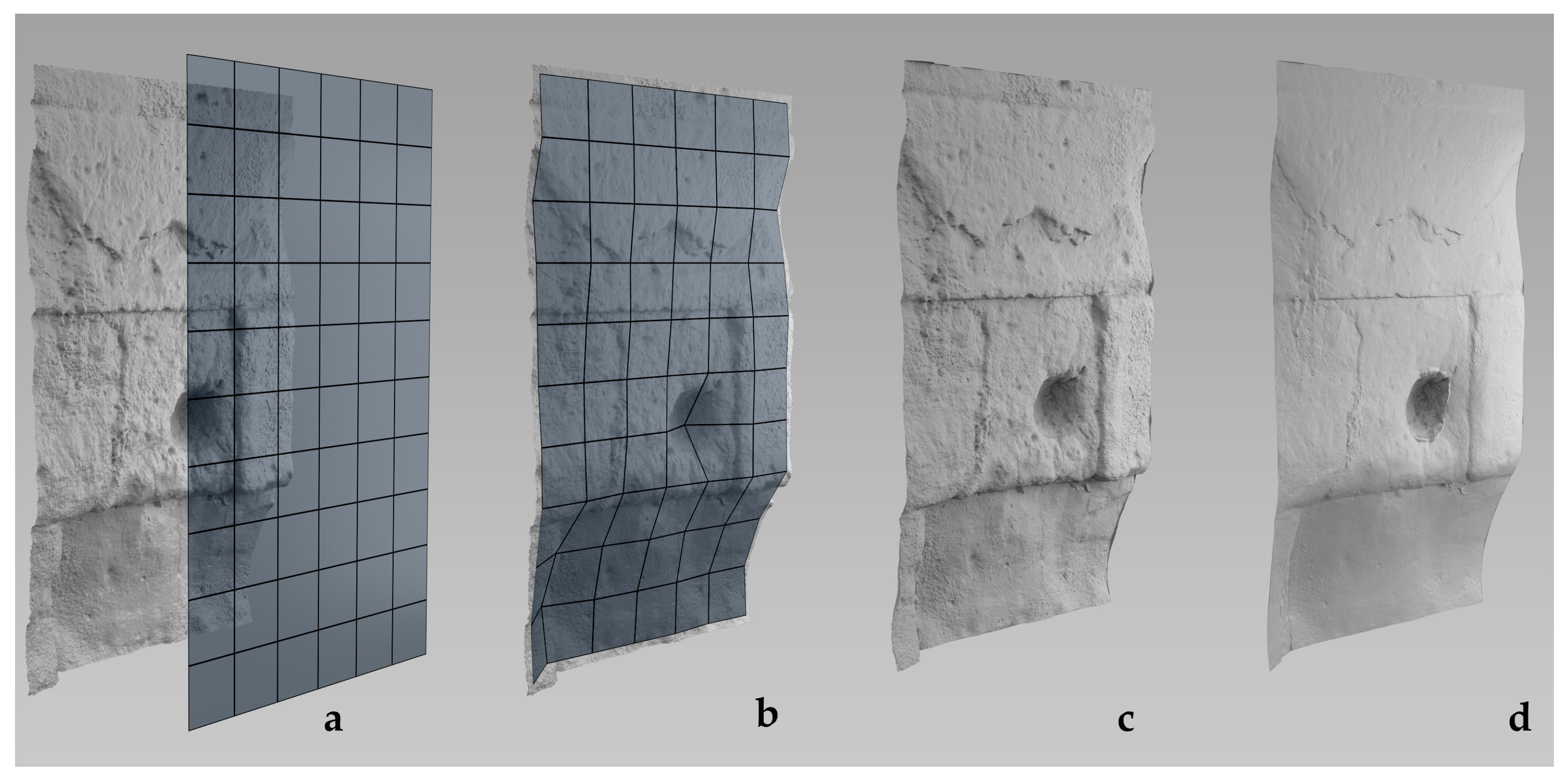
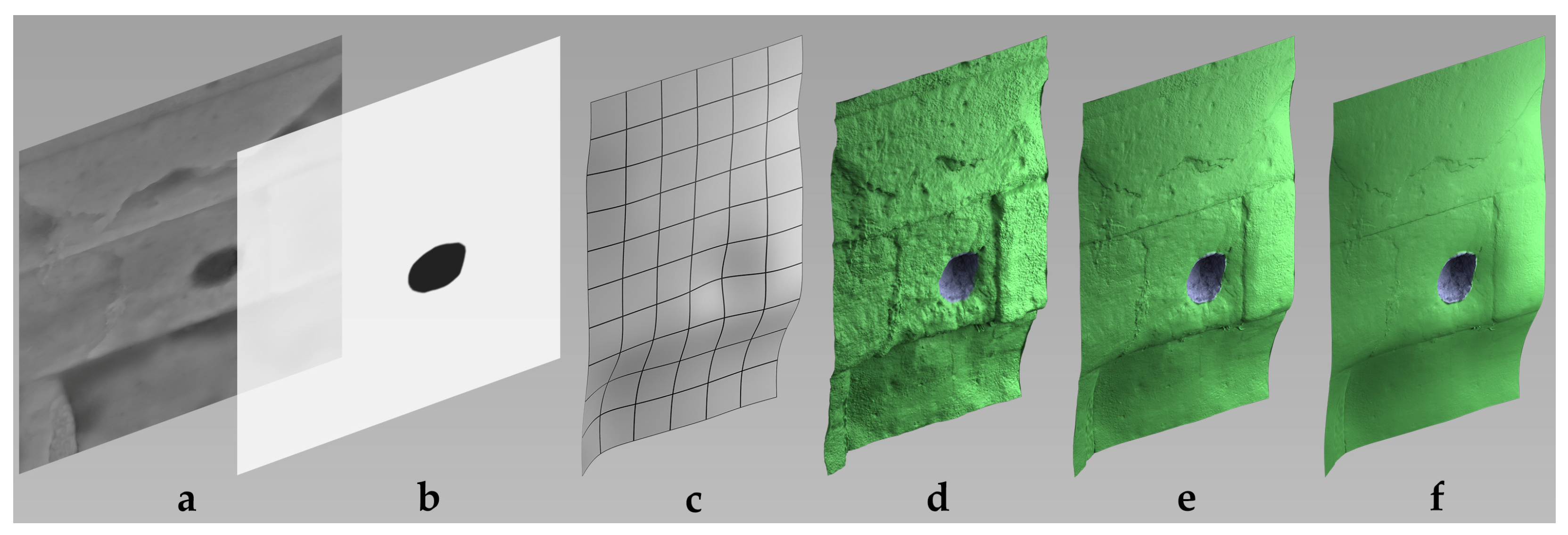
  • Mesh creation—The polygonal mesh processing was carried out using Geomagic Design X software (version 2016.1.1) [24] by manually segmenting the point cloud. This step was necessary due to the large size of the dataset, which was subdivided into different parts based on architectural elements (higher resolution) and other elements such as the environment, vegetation, and connections (lower resolution). The master model, representing the highest resolution version, underwent only minor modifications – such as small hole filling and minimal surface processing—to preserve the original geometry. This version was retained for scientific purposes, such as supporting archaeological hypotheses on the trajectory and impact force of projectiles used during the siege. The photogrammetric models were accurately scaled by aligning control points with the TLS point cloud.
  • Optimization phase—From the master model, a lighter version was created for dissemination purposes. This version included geometric reconstructions of missing parts, optimized geometry to reduce file size, and extrapolated missing elements where data were incomplete, using comparative reconstruction techniques (e.g., for the embankment). The goal of this optimized model was to prioritize visual clarity over scientific accuracy, making it more suitable for educational and exhibition purposes [25].
  • Texturing—This process was performed using Agisoft Metashape Professional software (version 2.2.1) to reapply the color appearance texture to the final model [26].
  • Virtual viewing—3D digital models are typically analyzed by scholars using specialized software with tools that enable detailed analyses, such as geometric pattern recognition, deviation measurement from reference entities, and other advanced functions. However, user-friendly alternatives are now widely available. Increasingly, 3D assets licensed under Creative Commons are accessible through popular online virtual platforms [27], allowing intuitive virtual navigation and interaction via multiple devices. These models can support virtual tours, interactive storytelling, and dynamic exploration. Advanced simulations to better understand the mechanics of ancient artillery through ballistic simulations are already in the planning stages. Additionally, annotations, cultural content, and supplementary materials can be linked to specific parts of the model, enhancing public engagement both on-site and online (Figure 10).
  • Design phase—A key step in the development of physical replicas was the selection of a representative section of the city walls. The chosen segment had to both illustrate the main architectural features and offer a clear cross-sectional view of the fortified structure. Additionally, the balance between model detail and printing scale was carefully considered to ensure the best resolution-to-size ratio [28].
  • 3D printing phase—Prototype models required watertight geometry and sufficient structural thickness for successful fabrication. Tactile models, designed for haptic exploration, had to meet specific accessibility requirements, including the addition of Braille labels for visually impaired visitors. Particularly, 1:1 scale 3D-printed replicas of impact cavities and projectiles were created to enable a direct comparative analysis between the missile size and the damage caused upon impact (Figure 11). This set of physical replicas, designed for an inclusive museum exhibit, allows visitors to better grasp the scale of the stone projectiles by visually and physically comparing them with the actual damage they inflicted on the walls.
All the proposed applications of digital models have proven to be an effective means of disseminating knowledge on Roman siege weaponry and the ballistic impact marks at Pompeii through emblematic case studies. In particular, tactile replicas of ballistic imprints demonstrated strong potential for accessibility, enabling immersive and interactive experiences that are also accessible to visually impaired visitors.

4. Discussion

The results highlight the significant transformative potential of digital heritage documentation, originally acquired for scientific research, in supporting inclusive dissemination. The integration of digital documentation methods not only enhances the accuracy of archaeological analysis but also improves the accessibility and interpretability of historical findings.
One of the key challenges lies in balancing accuracy and usability. While high-resolution models offer invaluable insights for specialists, their practical implementation in museum settings requires optimization to ensure interactivity and engagement. The integration of digital visualization, 3D prototyping, and tactile exploration represents a promising approach, ensuring that research findings are effectively conveyed to diverse audiences.
Additionally, this study demonstrates how digital reconstructions contribute to heritage conservation. The ability to digitally archive and assess the preservation state of archaeological remains provides a valuable tool for long-term monitoring and preventive conservation strategies.
However, some challenges persist, particularly in effectively communicating the ballistic imprints to general audiences and ensuring that their historical significance is properly understood. For this reason, future initiatives are planned, such as the installation of explanatory panels both on-site and within the museum, enabling visitors to directly compare contextual information with the actual city walls.
Further research is also needed to enhance tactile perception, particularly for small cavities that are difficult to discern through touch. Additional refinements, such as experiments with mesh displacement (Figure 12), should be explored. Recent studies suggest that specific model processing techniques can significantly enhance the tactile experience, making archaeological details more accessible to visually impaired users.
Tactile architectural models for blind and visually impaired users must exhibit specific physical representation features. In particular, they should be designed to emphasize and clarify the overall structure, while fine, high-frequency details should be either omitted or significantly subdued, as they may act as a form of “perceptual noise” that hinders rapid and accurate tactile perception. In the context of this case study, this issue necessitates the development of an ad hoc technique that enables the understanding of the general layout of the masonry and its individual blocks while simultaneously highlighting the presence of projectile-induced perforations.
The adopted technique is called displaced subdivision surfaces [29,30,31], which allows the use of 16-bit-per-channel OpenEXR displacement maps to accurately store the formal features of a high-detail model and transfer them onto a level-of-detail (LOD) surface, namely subdivision surfaces (or SubDs). The proposed solution involves applying the same OpenEXR displacement texture to the SubD model twice: the first application provides an overall level of detail to the tactile model without compromising the perception of its general structure (Figure 13). This texture is attenuated in intensity to prevent the 3D printing of excessively fine details that would be imperceptible to touch. The second application of the texture is used at full intensity but only in specific regions of the model—the areas corresponding to the impact deformations—thereby ensuring both legibility of the general form and tactility of the ballistic traces.

5. Conclusions

In recent decades, 3D sensing technologies and digital modeling, including related advancements such as 3D printing, have become essential tools not only for CH documentation but also for enhancing cultural awareness and, importantly, for educational dissemination aimed at non-expert users. Virtual applications now play a crucial role in increasing both sensory and cognitive accessibility, providing practical and sustainable solutions. In many cases, these digital resources are complemented by physical prototypes, allowing a broader and more inclusive audience to engage with cultural heritage (Figure 14).
This approach is particularly valuable in cases where direct access is hindered, whether due to physical inaccessibility or the complexity of the subject matter, such as ballistic imprints, which are not easily recognizable, especially to the untrained eye. In these instances, virtual models and 3D-printed casts serve as powerful tools to aid understanding and interpretation.
Beyond analytical applications, the study demonstrated the successful adaptation of 3D models for museum purposes, resulting in both virtual reconstructions and physical replicas. The printed replicas were produced in both full-scale and reduced-scale versions, with some incorporating Braille descriptions to enhance accessibility for visually impaired users. This multi-sensory approach enables a wider audience to engage with archaeological evidence, overcoming physical and conceptual barriers typically associated with this specialized field of research.
These tactile and digital resources could also be integrated in situ, further contributing to the broader dissemination of archaeological knowledge. By offering direct and enhanced visualization of prototypes within their original context or through exhibition experiences enriched with popularized historical information about ancient weaponry, this approach facilitates deeper public engagement. Additionally, the possibility of evaluating the destructive effects of these weapons through an immersive virtual platform further enhances visitor interaction.

Author Contributions

Conceptualization, S.B.; methodology, S.B.; software, F.F.; validation, S.B.; formal analysis, S.B.; investigation, S.B.; resources, F.F.; data curation, S.B.; writing—original draft preparation, S.B.; writing—review and editing, F.F.; visualization, S.B.; Survey, mesh modeling and rendering S.B.; elaboration of figures: Figure 1, Figure 2, Figure 3, Figure 4, Figure 5, Figure 6, Figure 7, Figure 8, Figure 9, Figure 10, Figure 11 and Figure 14 (S.B.) and Figure 12 and Figure 13 (F.F.). All authors have read and agreed to the published version of the manuscript.

Funding

This research was supported by the project “SCORPiò-NIDI”, CUP B53D23022100006 (DD n. 1012/2023), funded by the Italian Ministry of Research under the PRIN (call DD n. 104/2022) funding initiative.

Institutional Review Board Statement

Not applicable.

Informed Consent Statement

Not applicable.

Data Availability Statement

Research data are available upon request.

Acknowledgments

The authors would like to express their gratitude to the management and the appointed officials of the offices of the Pompeii Archaeological Park for granting authorizations for site access and survey operations.

Conflicts of Interest

The authors declare no conflicts of interest.

Abbreviations

The following abbreviations are used in this manuscript:
3DThree-Dimensional
ACArchitectural Complex
AOArchitectural Object
ASArchitectural Section
CHCultural Heritage
LODLevel Of Detail
SubDSubdivision surfaces
SfMStructure from Motion
SWSiege Weapons
TLSTerrestrial Laser Scanner
ToFTime-of-Flight

References

  1. Las Casas Del Alma: Maquetas Arquitectónicas de La Antigüedad (5500 a.C./300 d.C.); Azara, P., Ed.; CCCB Centre de Cultura Contemporània de Barcelona: Barcelona, Spain, 1997; ISBN 84-7794-501-2. [Google Scholar]
  2. Gavinelli, C. Storie di Modelli Esibitivi e Critici: Modelli Storico-Critici di Rappresentazione Oggettuale di Visualizzazione Interpretativa; Alinea: Florence, Italy, 1993; ISBN 2560005066993. [Google Scholar]
  3. Sardo, N. La Figurazione Plastica Dell’architettura. Modelli e Rappresentazione; Kappa Edizioni: Rome, Italy, 2004; ISBN 978-88-7890-562-7. [Google Scholar]
  4. Alberti, L.B. L’arte di Costruire. Bollati Boringhieri, 4th ed.; Giontella, V., Ed.; Bollati Boringhieri: Turin, Italy, 2010; ISBN 978-88-339-1882-2. [Google Scholar]
  5. Scolari, M. Il Disegno Obliquo. Una Storia Dell’antiprospettiva; Marsilio Editori: Venice, Italy, 2005; ISBN 978-88-317-8617-1. [Google Scholar]
  6. Manual de Museología Interactiva; Santacana i Mestre, J., Martín Piñol, C., Eds.; Ediciones Trea: Gijón, Spain, 2010; ISBN 978-84-9704-531-5. [Google Scholar]
  7. Bruciati, A.; D’Alessandro, L.; Empler, T.; Fusinetti, A. VILLÆ (Tivoli, MiC). Percorsi di inclusione museale e accessibilità. In Proceedings of the DAI-Il Disegno per l’Accessibilità e l’Inclusione. Atti del II convegno DAI, Udine, Italy, 1–2 December 2023; Sdegno, A., Riavis, V., Eds.; PUBLICA: Alghero, Italy, 2023; pp. 508–521. [Google Scholar]
  8. Bruciati, A.; D’Alessandro, L. Passepartout. Il museo di tutti per tutti. Un progetto di accessibilità delle VILLÆ. In Aree Archeologiche e Accessibilità. Riflessioni ed Esperienze; Anguissola, A., Tarantino, C., Eds.; Pisa University Press: Pisa, Italy, 2023; pp. 127–137. ISBN 978-88-3339-725-2. [Google Scholar]
  9. Van Buren, A.W. Further Studies in Pompeian Archaeology. Memoirs Am. Acad. Rome 1925, 5, 103–113. [Google Scholar] [CrossRef]
  10. Maiuri, A. Studi e Ricerche Sulla Fortificazione di Pompei; Monumenti Antichi pubblicati per cura della R. Accademia dei Lincei Hoepli: Milan, Italy, 1929; Volume 33. [Google Scholar]
  11. Van Buren, A.W. Further Pompeian Studies. Memoirs Am. Acad. Rome 1932, 10, 7–54. [Google Scholar] [CrossRef]
  12. Russo, F.; Russo, F. 89 a.C. Assedio a Pompei: La Dinamica e Le Tecnologie Belliche Della Conquista Sillana Di Pompei; Edizioni Flavius: Pompeii, Italy, 2005; ISBN 88-88419-32-2. [Google Scholar]
  13. Rossi, A. The Survey of the Ballistic Imprints for a Renewed Image of Unearthed Pompeii. Nexus Netw. J. 2024, 26, 307–324. [Google Scholar] [CrossRef]
  14. Bertacchi, S.; Gonizzi Barsanti, S.; Rossi, A. Geometry of Wall Degradation: Measuring and Visualising Impact Craters in the Northern Walls of Pompeii. SCIRES-IT-Sci. Res. Inf. Technol. 2024, 14, 111–128. [Google Scholar] [CrossRef]
  15. Rossi, A.; Gonizzi Barsanti, S.; Bertacchi, S. Use of Polybolos on the City Walls of Ancient Pompeii: Assessment on the Anthropic Cavities. Nexus Netw. J. 2024. [Google Scholar] [CrossRef]
  16. Lugli, A. Museologia; Jaka Book: Milan, Italy, 2009; ISBN 978-88-16-43033-4. [Google Scholar]
  17. Negri, M.; Marini, G. Le 100 Parole dei Musei; Marsilio Editori: Venice, Italy, 2020; ISBN 978-88-297-0078-3. [Google Scholar]
  18. Basso Peressut, L.; Caliari, P. Architettura per l’Archeologia. Museografia e Allestimento; Martinelli, C., Ed.; Prospettive Edizioni: Rome, Italy, 2014; ISBN 978-88-98563-06-7. [Google Scholar]
  19. Rossi, A.; Gonizzi Barsanti, S.; Bertacchi, S. Naturali o antropiche? Misura e visualizzazione delle cavità murarie in cerchie urbiche/Natural or anthropic? Measurement and visualisation of wall cavities in city walls. In Misura/Dismisura. Atti del 45° Convegno Internazionale dei Docenti delle Discipline della Rappresentazione/Measure/Out of Measure. Transitions; Proceedings of the 45th International Conference of Representation Disciplines Teachers, Padova, Italy, 12–14 September, 2024; Bergamo, F., Calandriello, A., Ciammaichella, M., Friso, I., Gay, F., Liva, G., Monteleone, C., Eds.; FrancoAngeli: Milan, Italy, 2024; pp. 1957–1978. [Google Scholar]
  20. Rossi, A.; Bertacchi, S.; Formicola, C.; Gonizzi Barsanti, S. Piccole indentazioni antropiche rinvenute nella riesumata cinta urbica di Cornelia Veneria Pompeianorum|The small anthropic traces found in the unearthed city walls of Cornelia Veneria Pompeianorum. Disegnare Idee Immagin. 2024, 69, 54–67. [Google Scholar] [CrossRef]
  21. Rossi, A.; Formicola, C.; Gonizzi Barsanti, S. Ingegna Romana. Dalle fonti ai modelli, dai reperti alle ricostruzioni. diségno 2024, 229–238. [Google Scholar] [CrossRef]
  22. Busana, M.S.; Farroni Gallo, F. Aisthesis. Scoprire l’arte in Tutti i Sensi. 2021. Available online: https://www.museoomero.it/servizi/pubblicazioni/rivista-aisthesis-scoprire-larte-con-tutti-i-sensi/aisthesis-numero-17-settembre-2021/il-progetto-temart-metodologie-e-tecnologie-per-la-stampa-3d-di-riproduzioni-tattili-di-maria-stella-busana-e-francesca-farroni-gallo/ (accessed on 21 March 2025).
  23. Leica Geosystems Cyclone [Software]. Available online: https://leica-geosystems.com/it-it/products/laser-scanners/software (accessed on 21 March 2025).
  24. 3D Systems Geomagic Design X [Software]. Available online: https://www.3dsystems.com/software/geomagic-design-x (accessed on 27 February 2025).
  25. Battini, C.; Fantini, F. Modelli tattili: Una questione di rappresentazione. In Nuove Immagini di Monumenti Fiorentini, Rilievi con Tecnologia Laser Scanner 3D; Bini, M., Battini, C., Eds.; Alinea: Florence, Italy, 2007; pp. 36–39. ISBN 978-88-6055-232-7. [Google Scholar]
  26. Apollonio, F.I.; Zannoni, M.; Fantini, F.; Garagnani, S.; Barbieri, L. Accurate Visualization and Interaction of 3D Models Belonging to Museums’ Collection: From the Acquisition to the Digital Kiosk. J. Comput. Cult. Herit. 2025, 18, 5:1–5:25. [Google Scholar] [CrossRef]
  27. Spiess, F.; Waltenspül, R.; Schuldt, H. The Sketchfab 3D Creative Commons Collection (S3D3C) 2024. Available online: http://arxiv.org/abs/2407.17205 (accessed on 22 April 2025).
  28. Balletti, C.; Ballarin, M.; Guerra, F. 3D Printing: State of the Art and Future Perspectives. J. Cult. Herit. 2017, 26, 172–182. [Google Scholar] [CrossRef]
  29. Lee, A.; Moreton, H.; Hoppe, H. Displaced Subdivision Surfaces. In Proceedings of the 27th Annual Conference on Computer Graphics and Interactive Techniques, New Orleans, LA, USA, 23–28 July 2000; ACM Press/Addison-Wesley Publishing Co.: New York, NY, USA, 2000; pp. 85–94. [Google Scholar]
  30. Catmull, E.; Clarck, J. Recursively Generated Bspline Surfaces on Arbitrary Topological Meshes. Computer-Aided Design 1978, 10, 350–355. [Google Scholar] [CrossRef]
  31. Sheffer, A.; Praun, E.; Rose, K. Mesh Parameterization Methods and Their Applications. CGV 2007, 2, 105–171. [Google Scholar] [CrossRef]
Figure 1. Ballistic marks on stone ashlars in the northern city walls near Vesuvio Gate.
Engproc 96 00011 g001
Figure 2. Mesh model of part of the walls near Vesuvio Gate: (a) current terrain level; (b) probable ancient terrain level at the base of the tower’s sally-port door for sorties.
Engproc 96 00011 g002
Figure 3. Global point cloud of the surveyed area. Perspective view from Vesuvio Gate toward Tower X.
Engproc 96 00011 g003
Figure 4. An example of detailed photogrammetric documentation of an impact crater case study.
Engproc 96 00011 g004
Figure 5. 3D digital model of the remains of Vesuvio Gate and the Castellum Aquae: (a) Perspective view; (b) Orthographic view. Here, the pronounced slope of the cobblestone road, which once led out of Pompeii through the northern gate, is clearly visible.
Engproc 96 00011 g005
Figure 6. Digital model of the surveyed wall section between the Vesuvio and Ercolano Gates, processed to locate the different types of ballistic traces. Top: General location between the two gates. Middle: Wall sections A, B, and C between Towers X and XI, with masonry-pattern specifications. Bottom: Detailed view of A-1 section.
Engproc 96 00011 g006
Figure 7. Feasibility study for a 1:50 tactile model of a section of the walls near the Tower of Mercurio, developed from the reality-based digital model to illustrate the spatial articulation of the sloping terrain descending from the northern wall toward Pompeii. Top: Overall layout of the proposed tactile model. Bottom: Detailed section highlighting the unearthed levels with simplified explanatory elements and Braille labels for visually impaired visitors.
Engproc 96 00011 g007
Figure 8. Design of the museum installation displaying the 1:1-scale 3D-printed prototypes of wall cavities and stone balls, with reference to the significant wall section, allowing tactile interaction.
Engproc 96 00011 g008
Figure 9. Digital reconstruction of the Roman scorpio elastic torsion engine, by C. Formicola.
Engproc 96 00011 g009
Figure 10. Virtual view on the Sketchfab platform, model with informative annotations.
Engproc 96 00011 g010
Figure 11. 3D digital model for 1:1-scale replicas: (a) positive replica of the ballistic crater in the wall (wireframe enabled); (b) its virtual negative mold (Matcap-render visualization).
Engproc 96 00011 g011
Figure 12. (a) High-poly model and low-poly quadrilateral mesh; (b) low-poly mesh constrained to the high-poly template; (c) displaced subdivision surface (SubD); (d) SubD with variable displacement intensity.
Engproc 96 00011 g012
Figure 13. (a) Displacement map in OpenEXR format. (b) Mask generated by mapping ballistic imprints using Fiji software (version 1.54p); (c) Subdivision surface (SubD). (d) Segmented, displaced SubD model. (e,f) Differential displacement intensity: impact traces retain the original high-relief detail (purple), while background relief is reduced to enhance tactile perception (green).
Engproc 96 00011 g013
Figure 14. Rendering of a proposed informative museum exhibit of the northern walls, showing the analysis of the different types of existing cavities and stone balls and 3D printed casts of the cavities.
Engproc 96 00011 g014
Disclaimer/Publisher’s Note: The statements, opinions and data contained in all publications are solely those of the individual author(s) and contributor(s) and not of MDPI and/or the editor(s). MDPI and/or the editor(s) disclaim responsibility for any injury to people or property resulting from any ideas, methods, instructions or products referred to in the content.

