1. Introduction
The rapid increase in space activity has led to a corresponding growth in the number of uncontrolled objects reentering Earth’s atmosphere. Space debris, encompassing inactive satellites, defunct spacecraft, and fragments from collisions, is becoming a persistent issue in low Earth orbit (LEO). While most of these objects burn up during reentry, larger debris can survive and pose risks to lives, ground infrastructure, and in-flight aircraft on an impacted path.
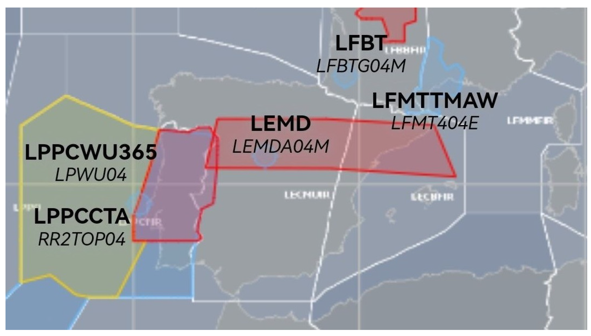
Air Traffic Management (ATM) is mainly affected by such events, with ATC being directly responsible for imposing safety measures. Uncontrolled reentries often require preemptive closures of extensive airspace regions, disrupting hundreds of flights and causing significant economic and operational consequences. For instance, the 4 November 2022 reentry of a Long March 5B rocket body resulted in airspace closures in Spain and France (see
Figure 1), impacting over 300 flights and creating cascading delays across the European network.
1.1. Motivation
Previous studies [
2,
3,
4] demonstrated that the temporal risk window for any ground position under the debris orbital track during reentry is limited to approximately one minute despite the broader uncertainties associated with the actual reentry point. This finding suggests that existing practices of large, static airspace closures are overly conservative. Advances in trajectory prediction and flexible airspace management concepts present an opportunity to minimize disruption while maintaining safety.
1.2. Objective and Structure
The primary objective of this paper is to explore operational strategies for reducing the impact of uncontrolled reentries on ATMs. We suggest adopting dynamic, moving airspace blocks that confine closures to precise locations and times by leveraging the temporal predictability of reentry events and existing (or already proposed) ATM mechanisms. The study further evaluates the feasibility of these measures using enhanced tracking methods and the integration of dynamic airspace allocation systems.
The paper is organized as follows. After a review of ATM implications of uncontrolled reentries and the limitations of current approaches in the Operational Challenges section. The Opportunities for Improvement section explores existing and proposed solutions to the problem. The Dynamic Airspace Management section is a lengthy but necessary discussion on FUA and AFUA. The next section, Transitioning from Spatial to Temporal Risk Management, details the main idea of this paper. It is followed by the Case Study: Applying the Proposed Strategy to the Long March 5B Reentry. The Conclusion summarizes the findings and makes some recommendations for future research.
2. Operational Challenges
The unpredictable nature of uncontrolled reentries forces ATM authorities to close large airspace areas, affecting numerous flights. For example, the reentry of a Long March 5B rocket body on 4 November 2022 led to airspace closures in Spain and France for 40 and 60 min, respectively. Over 300 flights were delayed or rerouted, with cascading effects on the European air traffic network. While the rocket ultimately broke apart over the Pacific Ocean, the decision to close airspace was based on an estimated 0.0000001 probability of collision between the rocket body and an aircraft, classified as extremely remote but still 100 times higher than typical aviation safety standards.
2.1. Uncertainties in Prediction
Accurately predicting the timing and location of uncontrolled reentries remains a significant obstacle. Atmospheric drag, influenced by ionospheric density, causes orbital decay and reentry [
2,
4]. However, variability in solar and geomagnetic activity introduces errors in estimating the start of reentry [
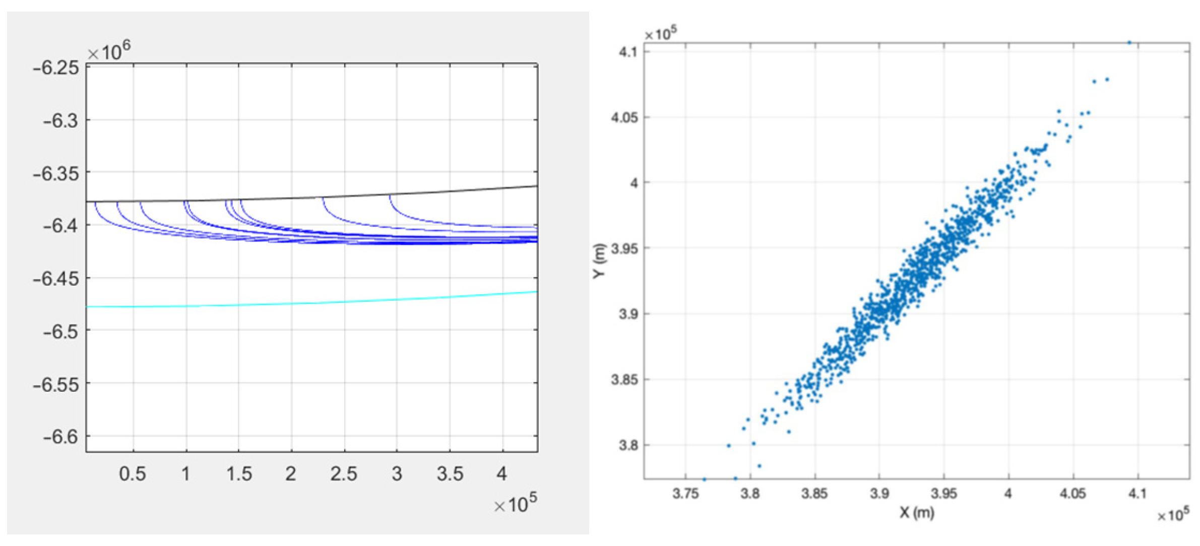
5]. Each second of timing error can shift the predicted ground track by approximately 7.5 km (
Figure 2).
Additional uncertainties stem from the object’s physical characteristics, such as shape, mass, and ballistic coefficients. These factors determine how objects respond to atmospheric forces, further complicating trajectory predictions. The resulting dispersions often span hundreds or thousands of kilometers along the predicted ground track [
6,
7], necessitating conservative safety margins in airspace management [
8].
2.2. Limitations of Current ATM Practices
Current ATM responses rely on static airspace closures based on worst-case scenarios. These closures cover extensive areas along the predicted reentry corridor (see
Figure 1), often far exceeding the risk zone. While effective in ensuring safety, this approach could be more efficient, impacting flights that may not be in immediate danger. For instance, during the Long March 5B reentry, the airspace closures affected a much larger area than the narrow zone at actual risk.
Reactive measures, such as real-time rerouting based on debris detection, were also proposed in the literature [
3,
4] but have limitations. While minimizing risks, these actions can significantly disrupt operations due to the impracticability of the airspace evacuation caused by the lack of precision in the reentry prediction. They also require large-scale deployment of radar sensors capable of detecting debris passing under the Karman line.
2.3. Opportunities for Improvement
The key finding from earlier studies is that the temporal risk for any given point during reentry is limited to about one minute. There is a clear need for more dynamic approaches that focus on the temporal nature of the risk.
One promising solution is the adoption of dynamic airspace allocation, where temporary restricted zones move in real-time with the predicted trajectory of the debris. This approach could confine closures to only the regions and times of actual risk, minimizing disruptions while maintaining safety. Implementing such measures requires advancements in collaborative decision-making among ATM stakeholders.
3. Mitigation Strategies
The cornerstone of any effective mitigation strategy is accurately predicting the time and location of uncontrolled reentries. Predictions rely on orbital element estimation from sensors and atmospheric models like NRLMSISE-00, which simulate ionospheric density. However, uncertainties in solar activity and debris’ geometric and inertial characteristics introduce significant errors.
EUSST—EU Space Surveillance and Tracking is the organism responsible for this in Europe [
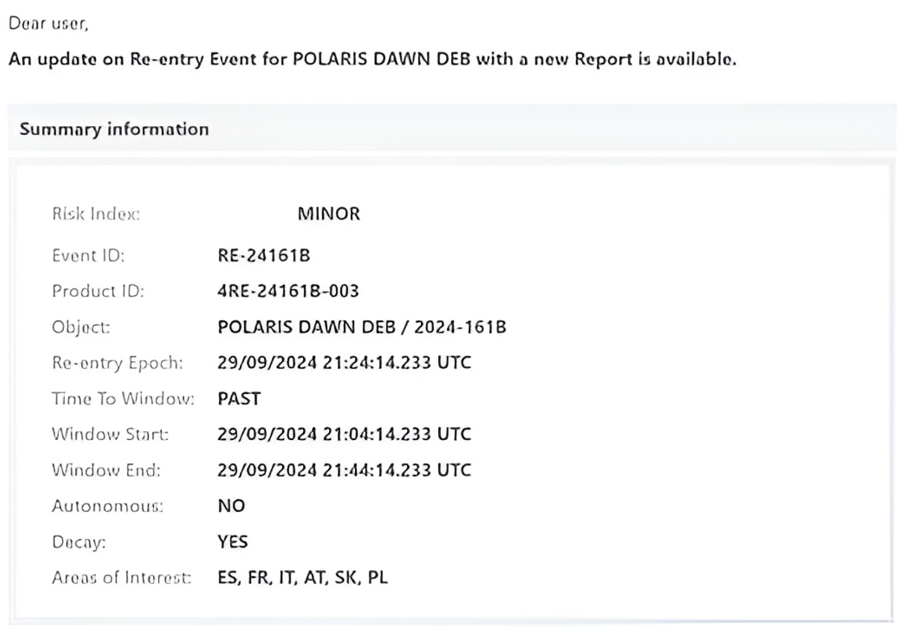
9]. Founded by the European Union, it provides critical tracking and prediction services for space debris, including uncontrolled reentries. The organization consolidates data from multiple European sensors, including ground-based radars and optical telescopes, and exchanges data with similar international organizations (mainly US counterpart Aerospace Corp. and IERS). It maintains EUSST databases and catalogs and delivers reentry forecasts and risk assessments like the one in
Figure 3 via the EUSPA front desk to member states, enabling informed decision-making for airspace management. For example, EUSST provided predictive data for the Long March 5B reentry, helping to refine hazard areas. It works closely with Eurocontrol, national authorities, and other stakeholders to integrate reentry predictions into airspace planning and real-time operations.
Improvement in prediction accuracy is ongoing, but there has yet to be a breakthrough in the foreseeable future. Deploying advanced tracking systems, enhancing atmospheric models with real-time solar and geomagnetic data, and integrating machine learning algorithms to refine trajectory predictions will gradually reduce the reentry window size, but there is no silver bullet.
3.1. Dynamic Airspace Management
Traditional static airspace closures could be inefficient and disruptive but are easy to implement. Dynamic airspace management offers a more targeted approach by confining restrictions to the regions and times of actual risk.
Flexible Use of Airspace (FUA) is the current state-of-the-art ATM framework for dealing with mixed airspace usage. It has already been implemented in all European countries at the national level and coordinated at the network level by Eurocontrol [
10].
It is implemented at three levels (strategic, pre-tactical, and tactical):
The strategic planning level deals with long-term agreements, airspace design, and the establishment of procedures and coordination mechanisms.
Pre-tactical management deals with the day-to-day allocation of airspace based on upcoming activities. This level is responsible for creating the Airspace Use Plans (AUPs).
The tactical level is the actual implementation of AUP and consists of real-time activation and deactivation of airspace sectors and immediate coordination to respond to unexpected demands.
It is, in essence, a mechanism for civil-military cooperation, but the existence of AUPs allows other authorized entities to request dynamic airspace allocation. AUP is elaborated daily (one day in advance) at the national level and centralized by Eurocontrol in a single document detailing the airspace allocation for the next day. In some cases, airspace allocation can be adjusted dynamically within shorter timeframes, such as 3–6 h or even real-time if necessary, but for emergency operations, airspace can be declared on much shorter notice, sometimes within minutes to hours, depending on the coordination capabilities.
FUA only allows fixed airspace block allocations. Reserved airspace can be implemented as Temporary Restriction Areas (TRA) or Danger Zones (DZ). Complications arise with airspace over high seas, which is outside national authority.
Unfortunately, FUA is not flexible enough to accommodate uncontrolled reentry events. However, a proposal for Advanced Flexible Use of Airspace (AFUA) resulting from SESAR will expand on existing principles to implement temporary, mobile-restricted zones.
AFUA will require [
11] advanced technologies that still need to be implemented, such as using advanced radar, satellite, and data link technologies for precise monitoring, surveillance, and tracking; real-time data sharing between airspace users and controllers; and 4D trajectory implementation. It will allow real-time activation and deactivation based on operational needs. The concept of interest inside AFUA is the Dynamic Mobile Areas (DMAs), a framework component designed to enhance airspace flexibility. They are categorized into different types based on their characteristics:
DMA Type 1: Pre-defined, static areas activated as needed.
DMA Type 2: Adjustable areas that can change shape or size within certain limits.
DMA Type 3: Fully dynamic areas that can move along a predefined trajectory and schedule.
The characteristics of DMA Type 3 are an ideal match for the problem at hand. These areas can move spatially over time, following a planned path. Their dimensions and activation times are dynamic and can be adjusted as required, but they will need advanced coordination between ANSPs, airspace users, and other stakeholders.
Designed to protect the airspace block around a moving target, the DMA could, in theory, move with the predicted debris trajectory.
However, AFUA still needs to have a time horizon for implementation, and it is not clear that it will support moving targets at orbital speeds. For now, the next step is to “simulate” such a mobile zone using the concepts currently implemented in FUA. Multiple static zones (e.g., Temporary Restricted Areas or Danger Zones) with sliding activation/deactivation times could emulate DMA 3 functionality. Challenges include coordinating activation for very short durations (e.g., 1–2 min) and adapting current ATM systems to support them.
3.2. Transitioning from Spatial to Temporal Risk Management
The proposed mitigation strategy is based on 4D trajectory predictions to pinpoint the specific times when regions/aircraft are at risk and time-based activation of the restricted zones that will fire in sequence, synchronized with the predicted timeline of the debris’ trajectory. This approach reduces the area affected at any given moment while maintaining safety and is implementable (if technical conditions allow for a one- or two-minute TRA/DZ activation) under the current FUA.
The implementation will also require close collaboration among all stakeholders, including air navigation service providers (ANSPs), airlines, and military authorities in pre-tactical and tactical stages. Leveraging existing frameworks like Eurocontrol’s collaborative decision-making (CDM) process can facilitate better coordination during reentry events.
The mitigation steps for implementation could be easily included in the current process for FUA. Based on advanced warnings from EUSST, at the pre-tactical planning stage, the uncontrolled reentry predictions will be integrated into Airspace Use Plans (AUPs) for the next day, ensuring all stakeholders are informed of potential events.
On the day of the event, real-time coordination between all ANSPs affected by the reentry will implement a “virtual” DMA. Establishing real-time communication channels between ATM authorities and ATMs and debris monitoring organizations will enable dynamic adjustments to the sequence of airspace closure and avoid unnecessary TRA activations.
4. Case Study: Applying the Proposed Strategy to the Long March 5B Reentry
A similar actual traffic situation (same season, same day of the week, same hour) was simulated to evaluate the proposal’s feasibility. The data source is FlightRadar24, and the procedure for converting the information into vector format is described in [
1]. The resulting cinematic simulation will allow for testing several simple ATC strategies.
Dynamic Airspace Allocation: A DMA 3 would be simulated using multiple overlapping TRA/DZ instead of broad closures in Spain and France. Each zone is the equivalent of 2 min at orbital speed (900 km × 30 km), and they are activated at 1 min intervals along the debris’ predicted trajectory.
Temporal Risk Management: Confined closures to two-minute windows along the predicted ground track are expected to reduce operational disruptions drastically.
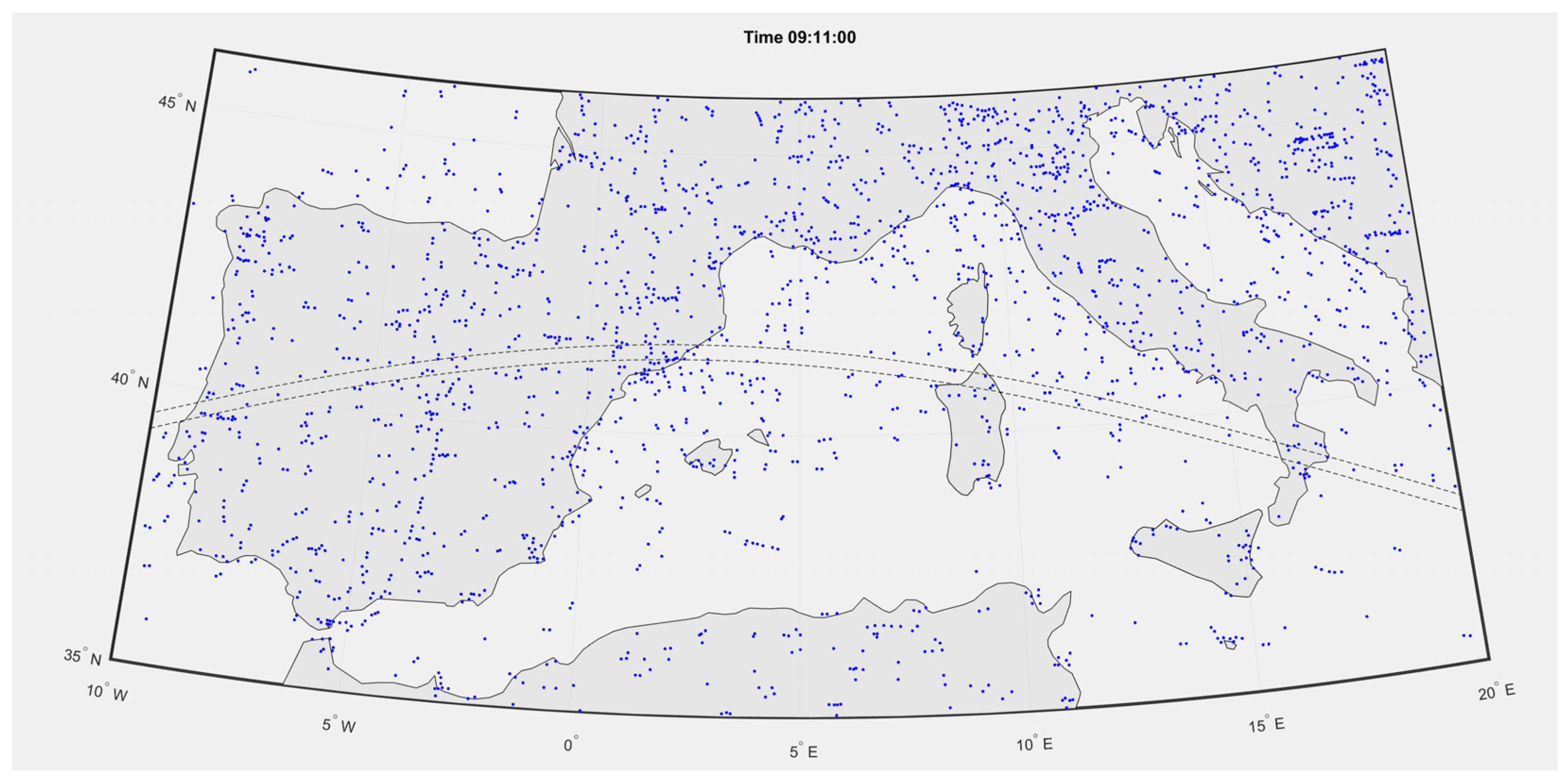
Figure 4 tries to give an idea about the aircraft at risk, but it is challenging to represent what is essentially an animation in a single picture. There is a 10 min delay between the west and east sides of the picture, so aircraft on the east side in the danger zone will exit it, and others will enter it.
An unperturbed traffic simulation allows us to identify the aircraft that violated the mobile pseudo-DMA: sixty-seven flights must avoid it. They were subjected to a simple speed control strategy of trying one of the following three commands in sequence until the exclusion criteria were met:
Decrease speed by 5, 10, or 15 kts with 2, 5, or 10 min before zone activation if the aircraft evolution is a cruise. The five-knots decrease is first tried for a prevention time of 2 min. If it fails, the prevention time is increased to 5 min and then to 10 min. If this also fails, the following speed decrement is tried, and so on.
Increase speed by 5 or 10 kts with 2, 5, or 10 min before zone activation if the first strategy does not work.
Delay take-off by 1, 3, or 5 min with no change in speed if the second strategy also fails.
No trajectory was modified or flight level changed; the three actions were tried in this order, aircraft by aircraft, until the threat was solved. Conflicts with existing traffic were verified for the simulated interval (the simulation only ran from 9:01 to 9:25; consequently, no subsequent conflict was checked after 9:25). Five new separation conflicts were detected and dealt with similarly (the conflicted aircraft were included in the list).
The resulting solution (which is far from optimal but proves the feasibility of the proposal) includes the following:
18 delayed take-offs, generally by three or five minutes.
29 increase speed “commands”.
25 decrease speed “commands”.
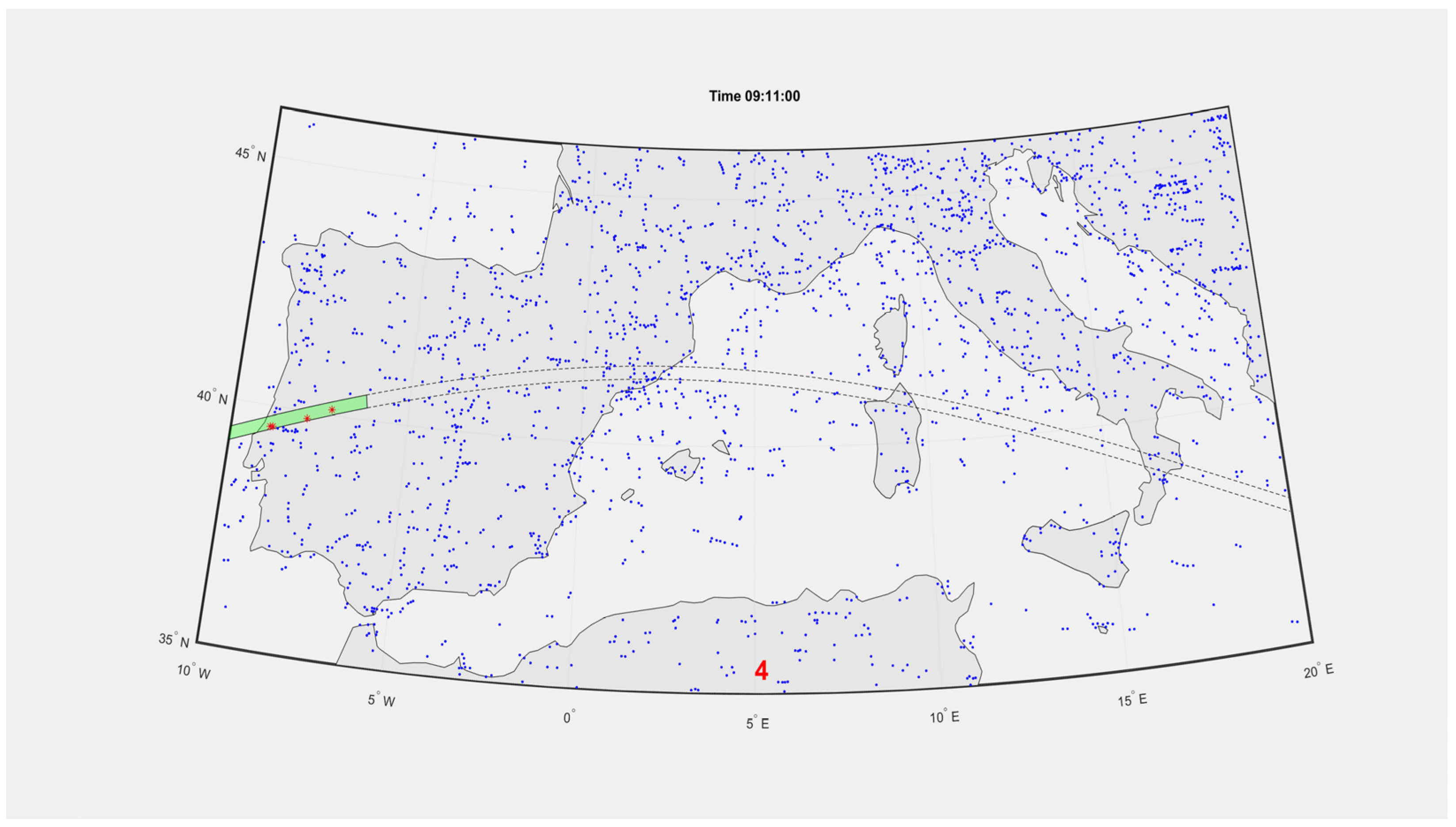
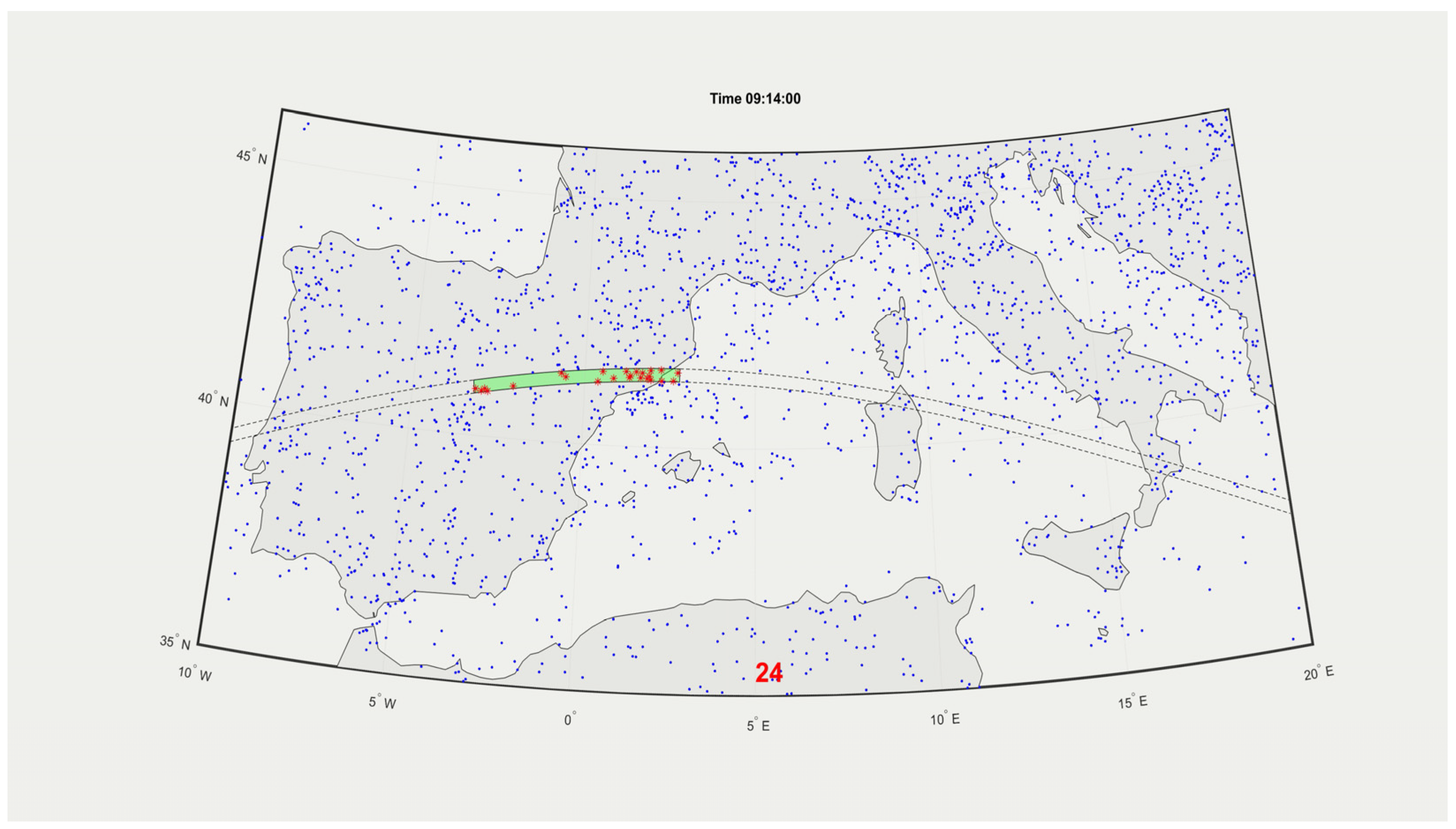
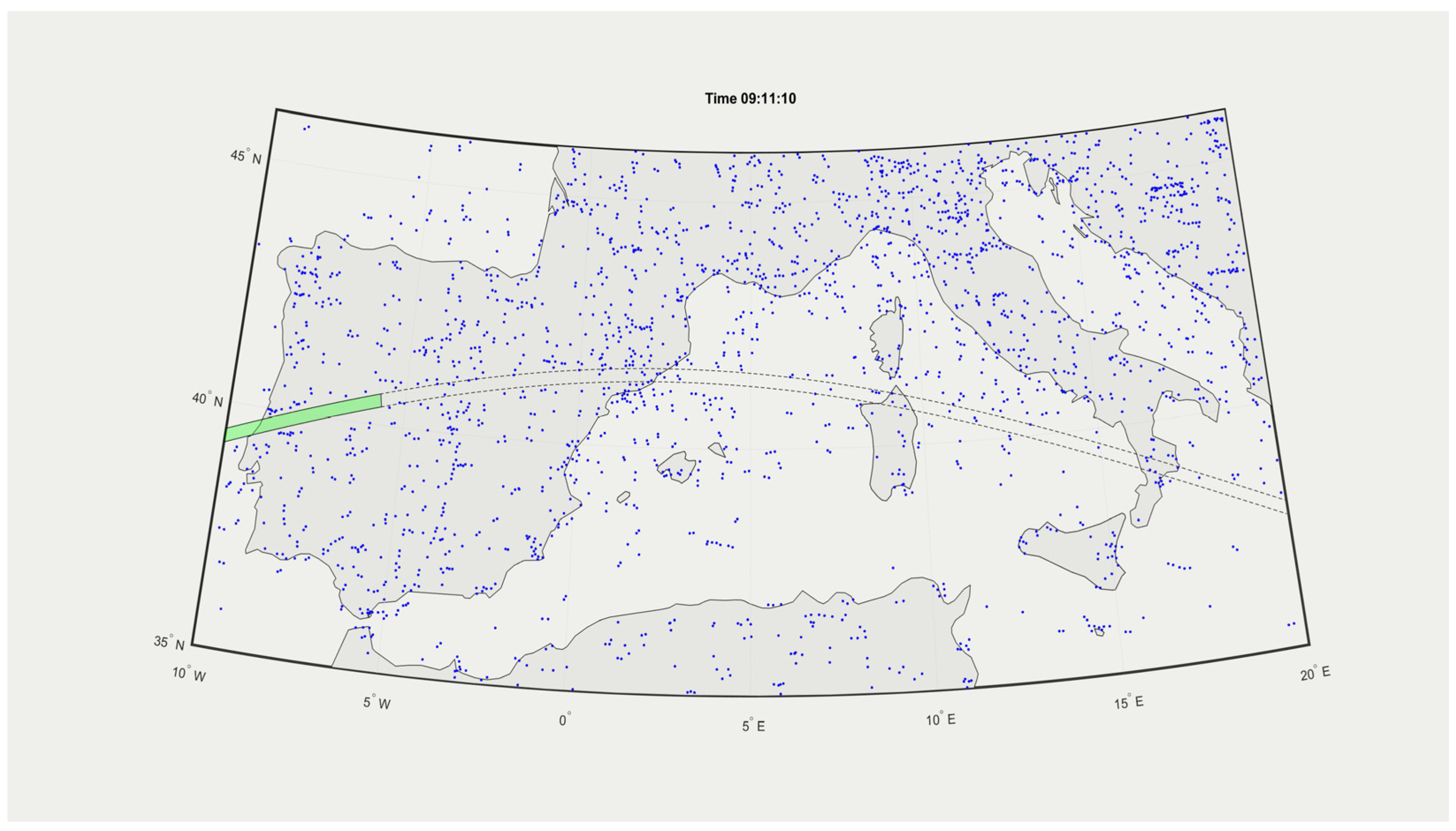
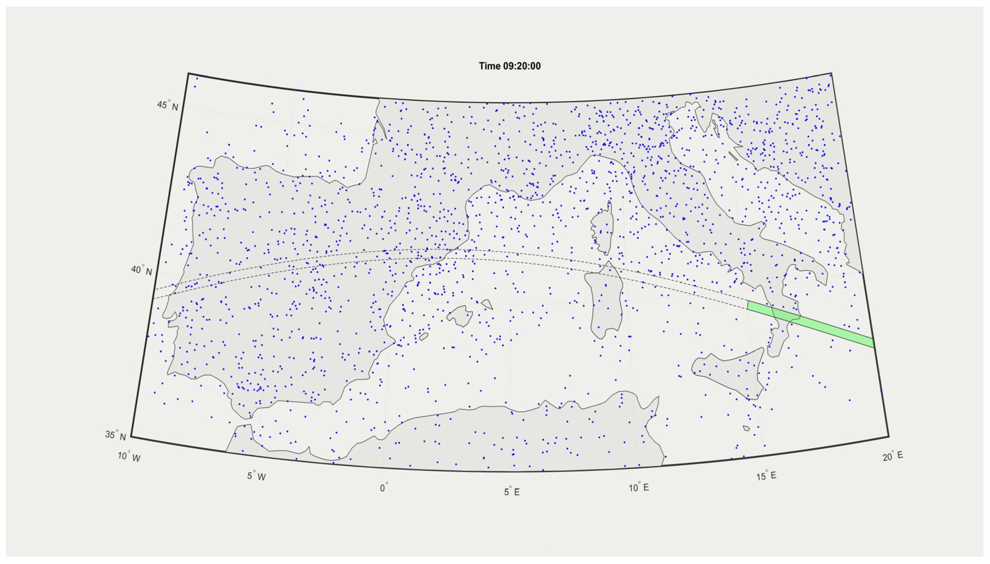
Figure 5,
Figure 6,
Figure 7,
Figure 8,
Figure 9 and
Figure 10 show the “before” and “after” situations in sequence and correspond to 9:11, 9:14, and 9:20, respectively. An analysis of the images corresponding to 9:11 reveals that while a DZ becomes active over Portugal, there is still traffic under the orbital track over the Tyrrhenian Sea, clearing the soon-to-be-activated DZ. A closer inspection of the middle images pair at 9:14 shows that traffic has already returned to normal over Portugal while the DZ “departs” eastern Spain. The last figure in the “after” sequence, at 9:20, when the sliding window reaches Zakynthos, shows a regular, undisturbed pattern for Portugal and Spain. The overall impact on air traffic is minimal compared to the total airspace shutdown that lasts 30 to 60 min for the static solution. Most of the perturbations induced by the “virtual” DMA will remain local and can be compensated over the remaining duration of the affected flights.


