1. Introduction
Riverfront zones represent dynamic interfaces between urban systems and fluvial or coastal hydrological processes. Historically, many urban settlements located along rivers and estuaries have leveraged their riverfronts for transport, industry, recreation, and as a public space amenity. However, these areas have become degraded due to being locked behind barrier infrastructures, dominated by ageing industrial uses, or disconnected from the city’s social and ecological networks. At the same time, flood-prone conditions in riverfront areas are intensifying due to urbanisation, land-use change, land subsidence, climate-driven changes in rainfall patterns, river discharge regimes, and sea-level rise [
1,
2].
Urban riverfronts face two challenges: regenerating and revitalising river corridors so that they become liveable, ecologically diverse, and socially accessible and strengthening their resilience against flooding, inundation, and hydrological extremes, which are projected to increase in both frequency and severity. Conventional flood protection measures, such as fixed flood walls, detached embankments, impermeable paved surfaces, and single-use zoning, can be used for short-term safety but often undermine ecological connectivity, riverfront amenity, and long-term adaptability to evolving flood regimes [
3].
In contrast, adaptive architectural and planning strategies for flood-prone riverfronts can be formulated to transition from resisting water to designing with water. These approaches enable built forms, landscape infrastructure, and socio-spatial systems to coexist with hydrological processes, absorb, store, and release floodwater, and respond dynamically to gradual changes in hazard conditions rather than relying on fixed design thresholds [
4,
5]. Such approaches underscore flexibility, multifunctionality, and the integration of built and natural systems, transforming riverfront regeneration for urban renewal and flood resilience.
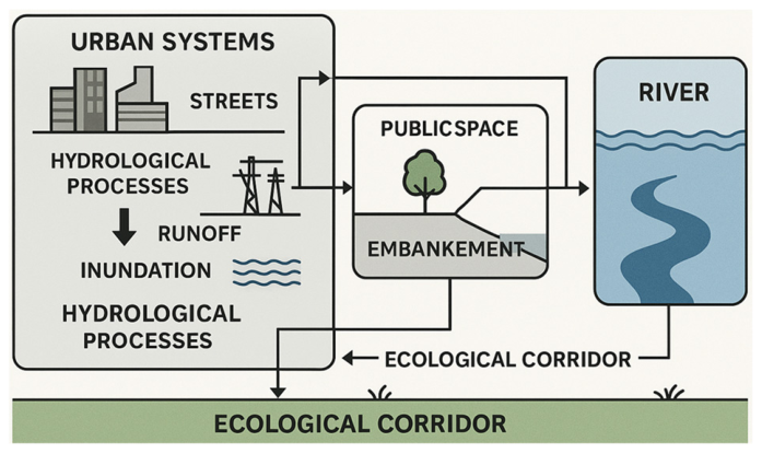
Figure 1 illustrates the interaction among urban systems, hydrological processes, ecological corridors, and infrastructure.
Consequently, riverfront regeneration in flood-prone environments is essential. When designed effectively, regenerated riverfronts can reconnect cities with their watercourses, strengthen ecological corridors, provide public amenities, and stimulate economic activity, while simultaneously embedding resilience through architectural and landscape interventions that accommodate flooding rather than merely resisting it. This regenerative process transitions defensive infrastructure in adaptive urban designs.
2. Literature Review
The riverfront zone can be conceptualised as a coupled socio-ecological–technical interface where hydrological processes, urban land use, ecological corridors, and infrastructure converge. Van Veelen describes waterfronts as transitional environments in which fluvial and tidal processes interact directly with built systems, highlighting the need for adaptive planning frameworks that allow zoning flexibility, long-term monitoring, and iterative adjustments to infrastructure and land use [
1]. Classical waterfront redevelopment, typical of late-20th-century post-industrial cities, emphasised real-estate valorisation, signature architecture, and recreational landscapes physically separated from flood-management structures such as dikes and retaining walls. In contrast, contemporary approaches argue for integrated regeneration, where flood resilience, ecology, and public space coexist as one spatial system. Visible and accessible riverfront designs can normalise living with water, increasing community acceptance of adaptive measures such as floodable parks or elevated riverwalks [
1].
Calcagni et al. regard low-lying waterfronts as climate-sensitive frontiers where sea-level rise, land subsidence, and urban development interact, requiring spatial strategies that integrate risk mapping with regenerative transformations [
2]. They define the urban–riverfront interface as a dynamic system in which flood risk, ecological value, and urban development cannot be treated separately. Their work demonstrates that resilient waterfront regeneration relies on multi-scalar mapping of vulnerabilities, coupled with nature-based flood mitigation and flexible spatial zoning. Governance mechanisms are central to this process, requiring cross-agency collaboration across water management, transportation, landscape architecture, and community sectors, supported by participatory processes that negotiate conflicting interests in high-value waterfront zones [
2].
Architectural strategies for flood-prone areas have evolved significantly. Mustafa provides a comprehensive evaluation of flood-proofing techniques, categorising them into dry-proofing, wet-proofing, elevation, and amphibious building systems [
3]. Dry-proofing aims to prevent water ingress, while wet-proofing accepts and controls inundation through water-compatible materials and relocatable mechanical systems. Building design is increasingly integrated into wider flood resilience urban systems, where ground floors, plinths, service cores, and circulation routes enable water conveyance or temporary storage during flood events. Architectural form is thus not an isolated artefact but an active hydraulic agent in riverfront resilience [
4]. Floodable public spaces, terraced embankments, wetland buffers, and amphibious buildings can be coordinated to form multifunctional, self-adjusting riverfront landscapes that serve both hydrological and recreational functions [
2,
3].
Researchers also emphasise nature-based solutions (NBSs) as part of flood resilience strategies. Azhar et al. show that portfolios combining engineered infrastructure (e.g., levees, pump stations) with NBS such as wetlands, bioswales, retention parks, and restored riverbanks outperform single-measure approaches under multi-scenario climate uncertainty. They further highlight the need for new financing models (e.g., blended public–private partnerships), maintenance regimes, and performance-based regulatory systems to sustain hybrid adaptation portfolios [
5]. Without such governance mechanisms, NBS and adaptive buildings risk under-performance or degradation over time.
Beyond hydraulics and ecology, social dimensions play a crucial role in riverfront adaptation. Gorzka et al. analyse waterfront public spaces across the Baltic Sea region and find that walkability, connectivity, and spatial continuity significantly enhance both everyday usability and emergency performance during flood events. High-quality, well-connected public spaces can double as evacuation routes, inspection paths, and floodwater corridors [
4]. This reinforces the claim that social acceptance and public-realm design are foundational to flood-resilient riverfront regeneration.
Despite significant progress, the literature reveals the following limitations.
Lack of integrated building-to-watershed frameworks, as architectural studies often focus on building-level flood-proofing [
3,
4], while landscape and urban studies consider catchment-scale solutions [
6,
7], with limited cross-disciplinary synthesis.
Limited quantitative evaluation of riverfront regeneration typologies, including amphibious housing, terraced embankments, floodable promenades, and hybrid public spaces.
Insufficient evidence linking adaptive architecture to socio-economic outcomes, such as visitor numbers, riverfront activation, or real-estate uplift.
Governance mechanisms remain under-specified, with few studies detailing how policy tools, building codes, or institutional capacities enable long-term adaptive implementation.
These limitations necessitate the approach adopted in the present study, which integrates architectural, urban, and ecological strategies; quantifies their hydrological and spatial impacts; and links them to governance considerations.
3. Methodology
In this study, adaptive architectural and planning strategies for riverfront regeneration in flood-prone areas were evaluated. The methodology integrates principles of adaptive waterfront planning [
1], vulnerability mapping [
2], architectural flood-proofing assessment [
3,
4], and hybrid adaptation portfolio evaluation [
5].
The analytical framework comprises the following components.
Comparative case study analysis to extract empirical practices from international riverfront regeneration projects that incorporate flood resilience.
Spatial–hydrological modelling to simulate flood storage capacity, runoff reduction, and ecological performance under alternative design scenarios.
Urban–architectural scenario development to test adaptive typologies such as floodable parks, terraced embankments, amphibious buildings, and permeable surfaces.
Governance and implementation assessment to evaluate enabling and constraining conditions related to planning instruments, regulatory frameworks, and stakeholder coordination.
This multi-layered approach facilitates the integration of architectural design, hydrological processes, and governance structures within a unified riverfront regeneration evaluation system.
Three international cases were selected based on the following criteria: (1) riverfront location with documented flood-prone conditions, (2) evidence of implemented or proposed adaptive architectural and landscape strategies, (3) availability of publicly accessible technical reports, master plans, or academic studies, and (4) relevance to the conceptual frameworks. In this study, the following cases were studied.
Cedar Rapids Riverfront: Noted for its hybrid levee–public space system and floodable greenway (Sasaki master plan).
Hangang Riverfront redevelopment: Exemplifying resilient design frameworks and multi-scalar ecological planning [
2].
Thu Duc City Riverfront: Integrating flood storage, blue–green networks, and adaptive land-use transitions.
Each case was analysed with respect to architectural typologies, landscape strategies, flood protection measures, ecological objectives, zoning instruments, and governance mechanisms. Data sources included academic publications, planning documentation, and open access design reports. From a literature review and case studies, two alternative design scenarios were developed for a hypothetical 5 km urban riverfront corridor.
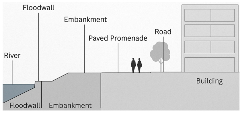
Scenario 1: Conventional Riverfront—characterised by a fixed-height flood wall, impermeable paved promenade, rigid embankment, non-adaptive buildings with dry-proofing only, and limited green space dominated by ornamental landscapes (
Figure 2).
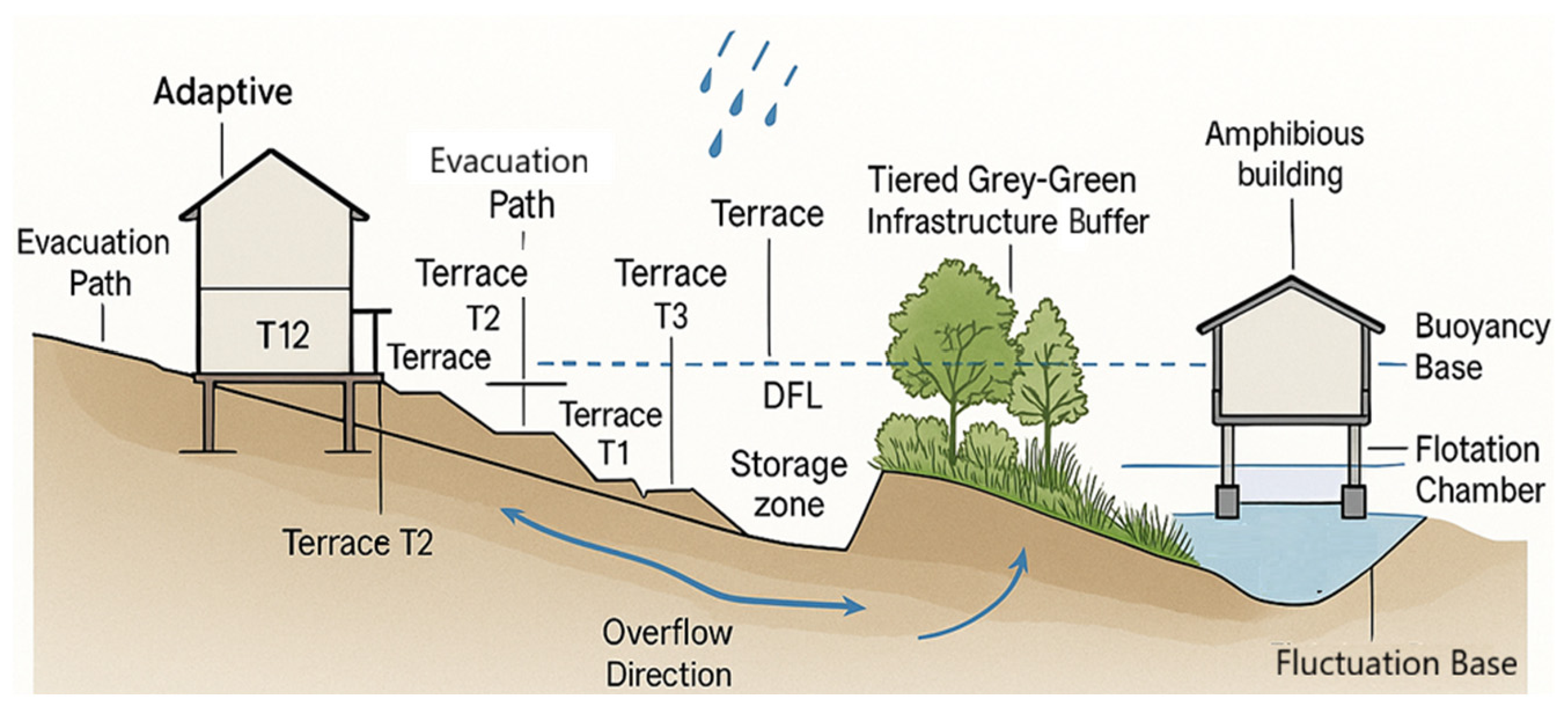
Scenario 2: Adaptive Riverfront—incorporating multifunctional terraced embankments with flood storage capacity, amphibious or elevated buildings informed by flood-proofing strategies [
3,
4], permeable and bio-retentive surfaces designed according to hybrid portfolio principles [
5], floodable public spaces (plazas and parks designed for safe inundation), and hybrid grey–green buffers supporting biodiversity, consistent with resilient waterfront principles [
2,
5] (
Figure 3).
Both scenarios were modelled in the geographic information system with consistent scaling, land-use allocations, and baseline site conditions.
Hydrological modelling is used to assess flooding behaviour and performance under the two scenarios. The modelling workflow includes the following variables: 50-year and 100-year flood hydrographs, local rainfall intensities, soil infiltration capacity, Manning’s coefficients for green and impermeable surfaces, design flood depths (based on regional flood-probability curves), and expected river discharge rates. Parameter values were adopted from peer-reviewed hydrological literature and adapted based on typical urban floodplain characteristics.
Figure 2.
Scenario 1: Conventional spatial configuration.
Figure 2.
Scenario 1: Conventional spatial configuration.
Figure 3.
Scenario 2: Adaptive spatial configuration.
Figure 3.
Scenario 2: Adaptive spatial configuration.
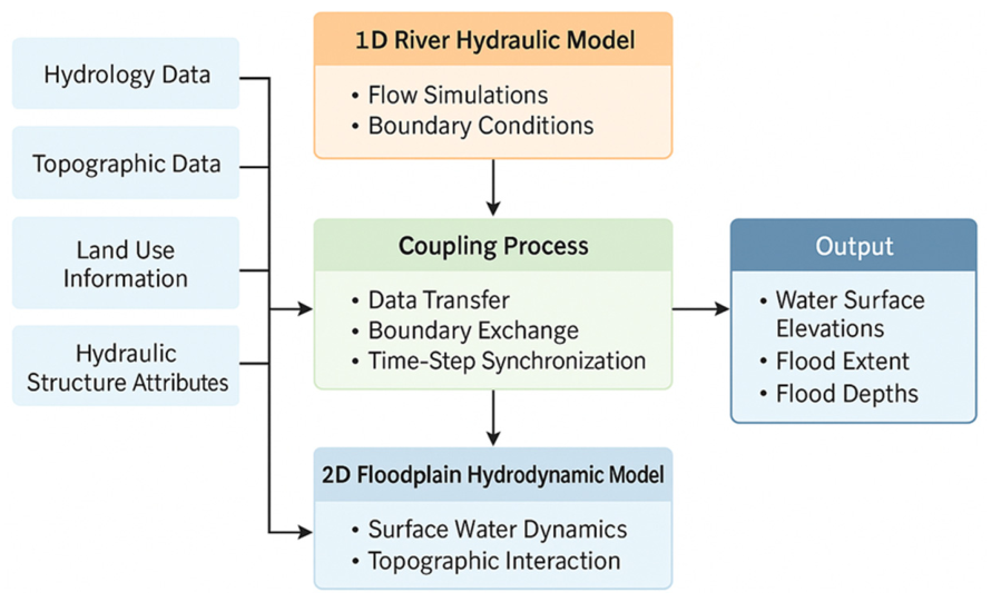
In this study, a simplified 1D–2D coupled flood model was constructed: a 1D model simulating river discharge and water-level variation, a 2D surface model simulating overland flow, flood spread, and storage across both scenarios. The model outputs include flood storage capacity (FSC) (m
3), peak water-level reduction (cm), runoff reduction (%) due to permeable and bio-retentive surfaces, and surface water propagation maps (flood extent and depth) (
Figure 4). Scenario 2 integrates nature-based and amphibious typologies shown to improve flood performance in prior studies [
3,
4,
5].
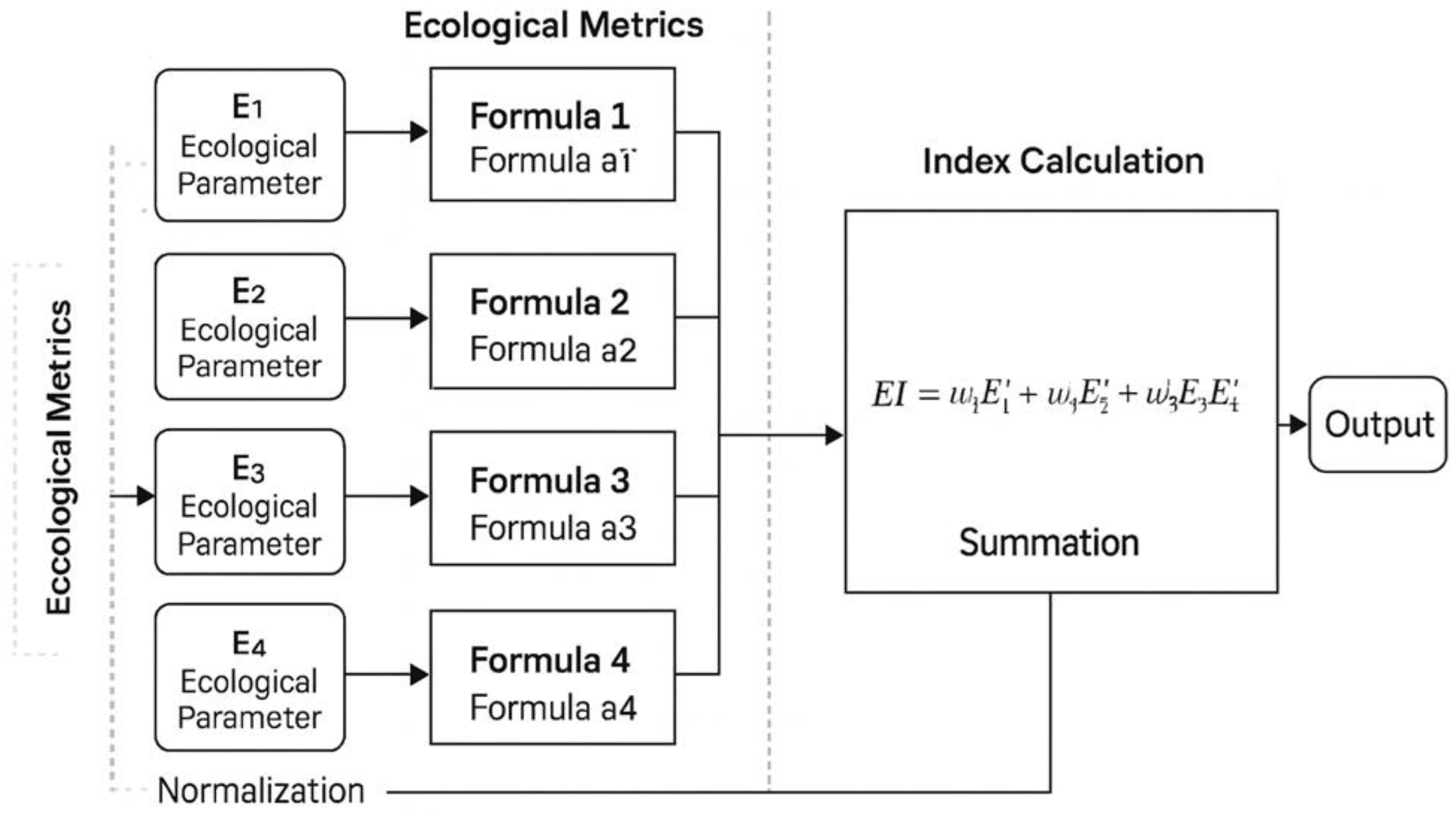
Ecological Index (EI) was also computed by combining three metrics: habitat connectivity score based on continuity of green corridors, vegetation richness potential inferred from land-cover typologies, and riparian buffer quality measured by effective buffer width (
Figure 5). These metrics align with resilient ecological corridor literature used in waterfront regeneration [
2].
Through GIS analysis, total public-open-space area (m
2), shaded walkway length (km), accessibility score (distance-based network analysis), river visibility, and adjacency metrics were obtained. These indicators are used to evaluate the public space performance emphasised in previous studies on urban riverfront [
1,
4]. Governance assessment followed the frameworks established by studies on adaptive planning [
1], resilient waterfronts [
2], and adaptation portfolios [
5].
The evaluation used five categories: planning flexibility, zoning adaptability, space for future retrofits, institutional coordination—cross-agency integration, regulatory enablers building codes, design guidelines for amphibious typologies. Stakeholder engagement involvement of local communities and river users. Maintenance and financing models ensure the long-term robustness of interventions. Each category was scored semi-quantitatively (1–5 scale) based on scenario characteristics. To compare the two scenarios, five primary indicators were defined as shown in
Table 1.
Validation was carried out by cross-checking the modelling outputs with parameters derived from comparable real-world case studies. Sensitivity testing was conducted for rainfall intensity, soil infiltration, and river discharge. The plausibility of scenarios was reviewed by referencing architectural adaptation frameworks [
3,
4] as well as hybrid adaptation strategies [
5].
The method in this study has limitations, such as the use of generalised site assumptions due to the hypothetical nature of the corridor. The absence of site-calibrated hydrological data affects the accuracy of absolute values. The governance index is partly interpretive because of the lack of jurisdictional context. EI is approximated, relying on vegetation typologies that have not been field-verified. Despite these limitations, the methodology provides a robust comparative platform for testing adaptive riverfront strategies.
4. Results
Table 2 presents the results of the comparative scenario modelling, case synthesis, spatial–ecological analysis, and governance evaluation. The results are organised according to the five performance indicators: FSC, runoff reduction, EI, Public space performance, and governance index. All modelling results were documented with reference to the hydrological and urban design assumptions that had been previously established. Flood storage capacity was calculated by analysing the available volume within terraced embankments, green-infrastructure depressions, and floodable public spaces.
Adaptive terraced embankments and integrated detention zones nearly double the storage capacity of the conventional riverfront model. The increase aligns with evidence from hybrid adaptation portfolios documented by Azhar et al. [
5]. Peak water-level reduction was derived from 1D to 2D hydrodynamic coupling.
In Scenario 2, peak flood levels were reduced by more than 20 cm in certain segments, confirming the hydraulic effectiveness of multi-level buffers and bio-retentive surfaces. By contrast, Scenario 1 exhibited broad inundation zones, particularly along impermeable promenade sections. Scenario 2 achieved a 34% reduction in flood extent, with shallow inundation confined to designated sacrificial floodable park zones. These results mirror flood mitigation behaviours documented in ecological riverfront projects, such as those reviewed by Calcagni et al. [
2]. The integration of permeable pavements, bioswales, and bioretention zones produced a significant reduction in flood impacts.
The 100% relative improvement in Scenario 2 demonstrates the effective incorporation of nature-based and hybrid drainage typologies, aligning with the recommendations of Mustafa and Ke for urban flood-resilient built forms [
3,
4]. Scenario 2 achieved a mean infiltration gain of 0.34 m
3/m
2, compared to 0.11 m
3/m
2 in Scenario 1, attributable to greater permeable-layer depth and enhanced catchment–channel connectivity. EI was calculated using the weighted hybrid formula defined earlier, incorporating habitat connectivity, vegetation richness, and riparian buffer quality (
Table 3).
Major factors of EI improvement include the expansion of riparian buffers. Buffer width increased from 8–12 m in Scenario 1 to 25–40 m in Scenario 2, aligning with resilient ecological corridor standards recommended by Calcagni et al. [
2]. In Scenario 2, continuous greenway connectivity delivered a 72% increase in linear ecological continuity. The species-rich planting palette adopted in this scenario incorporated wetlands, riparian shrubs, and flood-tolerant tree species, thereby enhancing biodiversity potential. As shown in
Table 4, the governance index reflects dimensions of regulatory adaptability, inter-agency coordination, implementation feasibility, and long-term maintenance capacity. Scenario 2 showed substantially higher scores due to its adaptive architecture (amphibious structures) which explicitly aligns with long-term, iterative planning models advocated by Van Veelen [
1] and Azhar et al. [
5].
5. Conclusions
Adaptive architectural and landscape strategies for riverfront regeneration in flood-prone areas were evaluated in this study through a combined methodological approach involving hydrological modelling, spatial–ecological analysis, comparative case study synthesis, and governance assessment. The results demonstrate that an integrated, adaptive riverfront framework that unites urban design, architecture, and ecological processes shows substantially higher performance than conventional, rigid riverfront configurations in most key resilience domains. The adaptive design scenario achieved a 132% increase in flood storage capacity and a 34% reduction in flood extent, supported by multi-level terraced embankments, permeable surfaces, and designated floodable public spaces.
Amphibious structures, elevated plinths, and wet-proofed ground levels significantly increased the adaptive capacity of the riverfront. The adaptive scenario demonstrated that buildings integrated with water dynamics can contribute to larger hydrological systems rather than merely attempting to resist them. EI ratings improved from 2.1 to 3.9, driven by expanded riparian buffers, strengthened habitat connectivity, and the introduction of flood-resilient vegetation communities. The results confirm that riverfront regeneration, when planned with ecological priorities, serves dual roles: restoring environmental quality and buffering hydraulic loads.
Public-open-space provision increased by 158%, and continuous walkways improved accessibility scores by 87%. The adaptive model’s expanded recreational landscapes demonstrated strong potential for social activation, projecting 138,000 annual visitors compared to 57,000 in the conventional scenario. These findings align with Gorzka et al.’s, which highlights the duality of waterfront public spaces as both social assets and flood-management infrastructure [
4], supporting the principle that high-quality public space is central to promoting community acceptance of living with water. Governance index increased from 2.4 to 4.2, reflecting improved adaptability, stakeholder engagement, and regulatory compatibility under adaptive planning frameworks. The results of this study demonstrate that resilience is not solely a design or engineering problem but also a governance challenge requiring iterative adaptation, multi-agency coordination, and hybrid financing mechanisms.