1. Introduction
In recent years, unmanned aircraft systems (UASs) have gained increasing popularity and are already being employed in a wide range of civil and military applications. The concept of urban air mobility (UAM) has emerged as a promising framework for deploying UASs in urban environments, offering new services and operational opportunities [
1].
However, operating UASs in urban and populated areas brings significant challenges in terms of safety, privacy, and cybersecurity [
2]. As a result, national aviation authorities (NAAs) impose stringent restrictions on UAS operations in such contexts. Currently, most flight missions are limited to controlled environments and conducted under visual line of sight (VLOS) conditions. However, fully exploiting UAS capabilities in urban contexts depends on the possibility to perform beyond visual line of sight (BVLOS) operations.
In Europe, BVLOS operations in populated or sensitive areas require a comprehensive risk assessment following the Specific Operations Risk Assessment (SORA) methodology [
3]. Despite its importance, performing a SORA analysis is often a complex and time-consuming task for UAS operators, primarily due to the lack of operational data, tools, and methodological expertise.
To support UAS operators, EASA has introduced scenarios in which the SORA is already predefined, namely the standard scenarios (STS) and predefined risk assessments (PDRAs). However, these scenarios remain limited in scope and do not cover many of the operational contexts that are commonly required by UAS operators.
For this reason, several tools have been developed to assist operators in preparing and performing the SORA process. Some of these tools mainly offer guided support for completing the SORA methodology step by step. For example, Ref. [
4] proposes a software tool that helps operators to navigate each phase of the assessment. A similar philosophy underlies a number of web-based applications that are already publicly available [
5,
6,
7]. Of particular relevance is the SORA Tool [
8], which provides a structured implementation of the complete methodology and assists UAS operators in generating the documentation required for submission to the NAA.
Other works focus instead on providing enhanced support for the underlying risk assessment. For instance, Ref. [
9] introduces an interactive interface for exploring operational parameters in real time, whereas [
10] presents a tool that is capable of performing probabilistic risk evaluations for fixed-wing UAS operations, complementing the SORA workflow.
However, none of these solutions provides a comprehensive and user-friendly workflow for UAS operators. The existing tools typically either replicate the individual steps of the SORA methodology or implement only selected portions of the risk assessment process without offering integrated risk assessment and planning capabilities.
To address these limitations, this paper presents the development of a web-based application designed to support UAS operators in planning safe and regulatory-compliant missions. The proposed web app integrates both mission planning functionalities and a step-by-step implementation of the SORA methodology. Specifically, we adopted the SORA 2.5, i.e., the most recent version adopted by EASA [
3]. This web-based tool builds upon the mission planning framework previously presented in [
11], providing the first concrete implementation of its key elements. While the work in [
11] introduced the conceptual architecture and workflow, the present work delivers an operational user-oriented application that preliminarily integrates both mission planning and SORA 2.5–based risk assessment.
A distinctive feature of the proposed tool is its integration with geospatial risk maps [
12], which introduces a high-fidelity risk-estimation approach within the SORA framework. In addition to supporting operators in completing the SORA 2.5 assessment, the web app integrates a risk-aware path planner capable of computing safe flight corridors that minimize both flight time and cumulative ground risk by leveraging risk maps. This dual capability of combining formal SORA compliance with risk-aware mission planning allows operators not only to perform the required risk assessment but also to gain a clear and quantitative understanding of how risk is distributed across the operational area.
The rest of the paper is organized as follows.
Section 2 presents the adopted methodology, describing both the high-fidelity risk assessment approach and the risk-aware path-planning algorithm.
Section 3 illustrates the results of the preliminary implementation of the web app through a representative use-case scenario. Our conclusions are drawn in
Section 4.
2. Risk-Aware Mission Planning Methodology
The mission planning methodology adopted in this work was first introduced in our previous study [
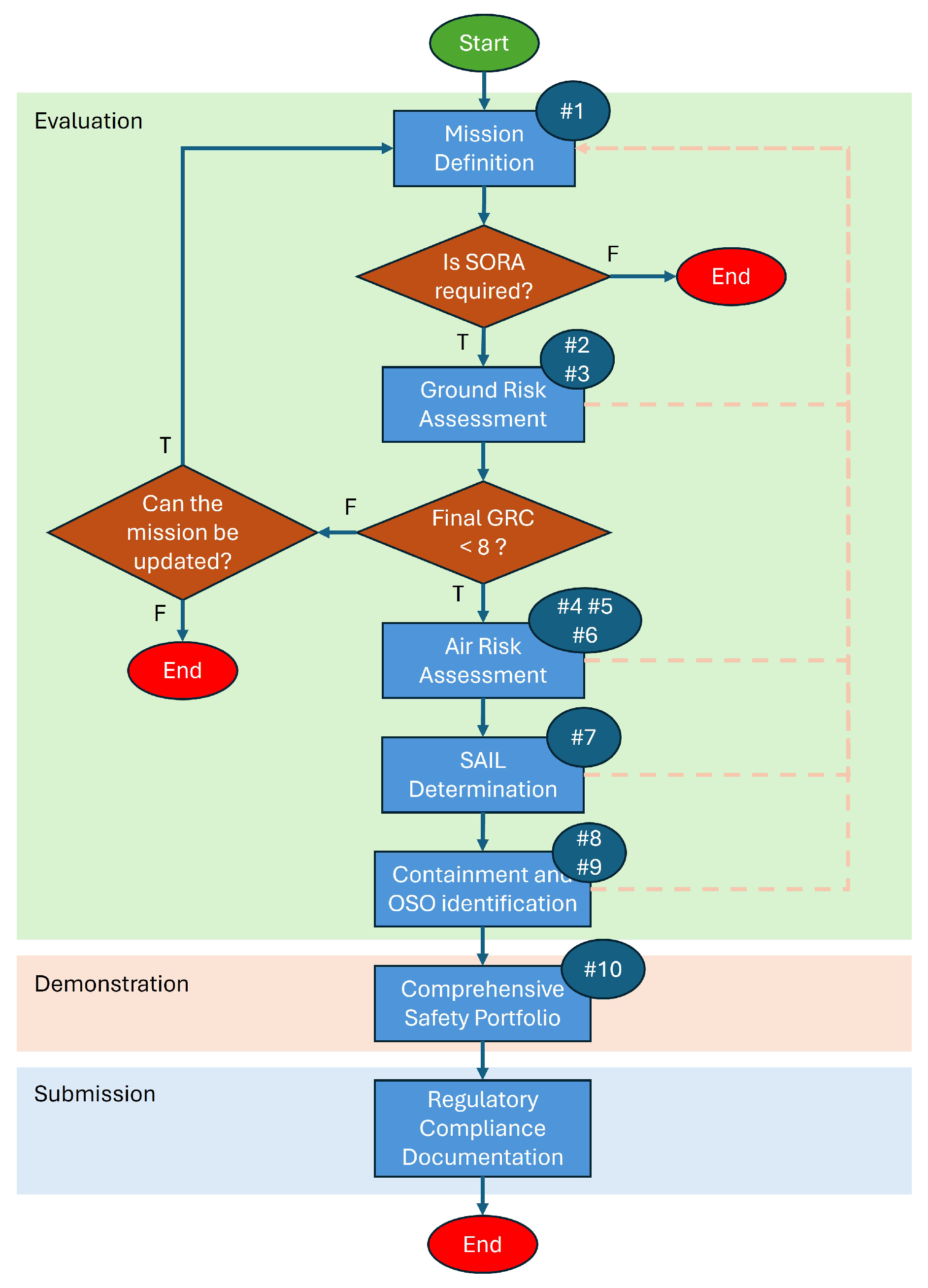
11], where we defined the main requirements and functionalities of a risk-aware mission planning and monitoring framework. The web-based tool presented in this paper represents the first operational implementation of the mission planning component. The workflow, illustrated in
Figure 1 and fully aligned with SORA 2.5, covers all steps from mission definition to documentation generation. A brief summary is reported here, while the full description can be found in [
11].
The process begins with mission definition, where the operator specifies the operational context (location, aircraft characteristics, flight height, VLOS/BVLOS mode, and mission type). Based on this information, the tool checks whether the SORA is required and suggests possible STS or PDRA scenarios when applicable.
The second phase involves the ground risk assessment, where the operator interacts with geospatial risk maps to inspect population density and ground risk distribution. At this stage, the tool computes the iGRC and allows the user to adjust the operational area or mission points accordingly. The workflow also includes the risk-aware path-planning module, producing low-risk routes that the operator may optionally refine.
Next, the operator defines the mitigations, which may include both automatically suggested elements (e.g., reducing risk through optimized routing) and operator-provided justifications or documentation. Based on these inputs, the final GRC is computed, and the operator may iterate the previous steps if the resulting level is not acceptable.
Then, the air risk assessment evaluates the airspace class and supporting information (e.g., NOTAM issuance), followed by the definition of strategic mitigations to determine the residual ARC and the TMPR (Tactical Mitigation Performance Requirement). Once the final GRC and residual ARC are established, the SAIL level is obtained. Subsequently, the operator identifies the containment requirements (basic or enhanced) and the associated OSOs (Operational Safety Objectives).
All these steps form the evaluation phase, where users can easily modify any input and immediately observe how changes affect the resulting risk and requirements, an essential feature given that operators often lack upfront awareness of SORA implications.
Finally, the operator completes the Comprehensive Safety Portfolio, assembling all evidence, documentation, and justification for the selected mitigations. The tool then produces an editable output document compliant with NAA requirements.
This paper implements only the evaluation phase of the methodology. Through a guided and user-friendly interface, the tool supports operators in completing all phases of the SORA evaluation, from defining the mission parameters to determining the resulting SAIL. The following paragraphs describe in detail the high-fidelity risk assessment approach adopted to generate the risk maps, as well as the risk-aware path-planning algorithm integrated into the tool.
2.1. High-Fidelity Risk Assessment
The SORA methodology provides a structured process for evaluating ground risk but relies on predefined population-density classes and does not account for sheltering effects or high-resolution spatial variations. In urban environments, these limitations may lead to conservative or inaccurate estimates. A more detailed quantification of ground risk can therefore improve both safety and operational flexibility.
In this work, high-fidelity ground risk estimation is performed using a probabilistic framework widely adopted in the literature [
13] and previously formalized in our earlier study [
12]. The ground risk is defined as the expected frequency of fatalities, expressed in fatalities per flight hour (
), and computed as
where
denotes the ground-impact accident rate,
the number of people exposed to the impact, and
the probability that an exposed person suffers fatal injuries. The detailed formulation of each term is provided in [
12].
Accurate computation of these quantities requires realistic and consistent input data. The value of
typically depends on aircraft class, design robustness, and human-factor contributions [
14]. The estimate of
is strongly influenced by the resolution and reliability of the population data, whereas
must consider the sheltering factor, i.e., how buildings or structures may shelter people on the ground. A conservative approach is advised when such information is uncertain.
To support mission planning, the resulting risk values are visualized through risk maps, previously introduced in [
12]. A risk map is a two-dimensional location-based map in which each cell contains the locally estimated ground risk value derived from the high-fidelity risk assessment. This representation provides UAS operators with an intuitive understanding of risk distribution across the operational area.
Risk maps may also serve as a strategic mitigation (M1) within the SORA framework, with a medium–high level of robustness, particularly for demonstrating the effect of sheltering and for validating operational restrictions intended to reduce risk. As established in the SORA and the related literature [
13], the target Equivalent Level of Safety (ELOS) is
. The achievable robustness level depends on the quality of the input data and the compliance with the SORA requirements.
2.2. Risk-Aware Path Planning
A further key functionality of the web-based tool is the integration of a risk-aware path-planning module. In this work, we adopt the methodology introduced in [
15], implementing a planner based on the well-known RRT* (optimal rapidly exploring random tree) algorithm. RRT* incrementally explores the search space (here represented by the risk map) by growing an optimal tree rooted at the starting point. The planner iteratively expands the tree while minimizing a user-defined cost function. In our implementation, the cost reflects a combination of cumulative ground risk along the route and estimated flight time, allowing the algorithm to identify a single optimal branch connecting the start and goal locations.
This formulation is particularly relevant because ground risk is expressed as an hourly frequency. Therefore, minimizing flight duration directly contributes to reducing overall exposure. The result is the minimum-risk path over the risk map, avoiding high-risk areas whenever possible.
Although this approach is not applicable to all mission profiles, it is especially advantageous for missions involving transit between fixed points, such as delivery and logistics, where both risk reduction and route efficiency represent critical operational objectives.
2.3. Implementation
The proposed web-based tool is implemented as a cloud-ready web application composed of a modern single-page frontend and a set of containerized backend services. The architecture is designed to keep the client lightweight while delegating computationally intensive tasks, such as risk-map generation and risk-aware path planning, to dedicated ROS2 modules running in the backend.
On the client side, the user interface is developed using the React 19.2.6 framework (Meta Platforms, Inc., Menlo Park, CA, USA) together with Material UI (Material-UI SAS 2025, Paris, France) for layout and components. Geospatial visualization is handled through Leaflet v2.0.0, which provides interactive map rendering and allows operators to select areas of interest, inspect overlays, and configure mission parameters. All interactions with the backend are performed through REST APIs, ensuring clear separation between presentation and processing layers and enabling straightforward deployment in cloud environments. The services are orchestrated through Docker Compose v5.1.3 (Docker, Inc., Palo Alto, CA, USA), with seamless scalability to Kubernetes if required.
The backend consists of two layers: a REST service and a set of ROS2 (version 24.04) nodes written in C++. The REST API acts as the gateway between the web application and the robotics layer. Incoming HTTP requests, such as risk-map queries or path-planning calls, are translated into ROS2 service requests, and the results (e.g., encoded TIFF maps, metadata, or waypoint lists) are serialized and returned to the client. Each component runs in an isolated container, ensuring reproducibility and facilitating distributed deployment.
The core computation is performed within the ROS2 environment. For risk-map generation, the system relies on the GridMap library, which provides a structured representation of multiple geospatial layers, particularly the following:
A building layer, derived from OpenStreetMap data, is used to evaluate the sheltering factor based on local urban morphology;
A population-density layer, provided by WindTre (Rome, Italy), contains estimates of population distribution with hourly granularity. The values used in this paper are realistic but synthetic due to data-sensitivity constraints.
These layers are combined within the ROS2 node implementing the high-fidelity ground risk model described earlier.
For the risk-aware path planner, we exploit the OMPL library in its C++ implementation. The planner computes minimum-risk routes over the risk map using an RRT*-based strategy and returns a set of waypoints that can be directly executed by the mission planning module.
From the user’s perspective, the web application exposes three main workflows: (i) risk-map generation; (ii) risk-aware mission planning; and (iii) the SORA 2.5 evaluation, where the tool provides a guided workflow that reuses both the computed parameters and the intrinsic GRC embedded in the risk map.
3. Results
This section presents the results obtained with the preliminary implementation of the proposed web-based tool.
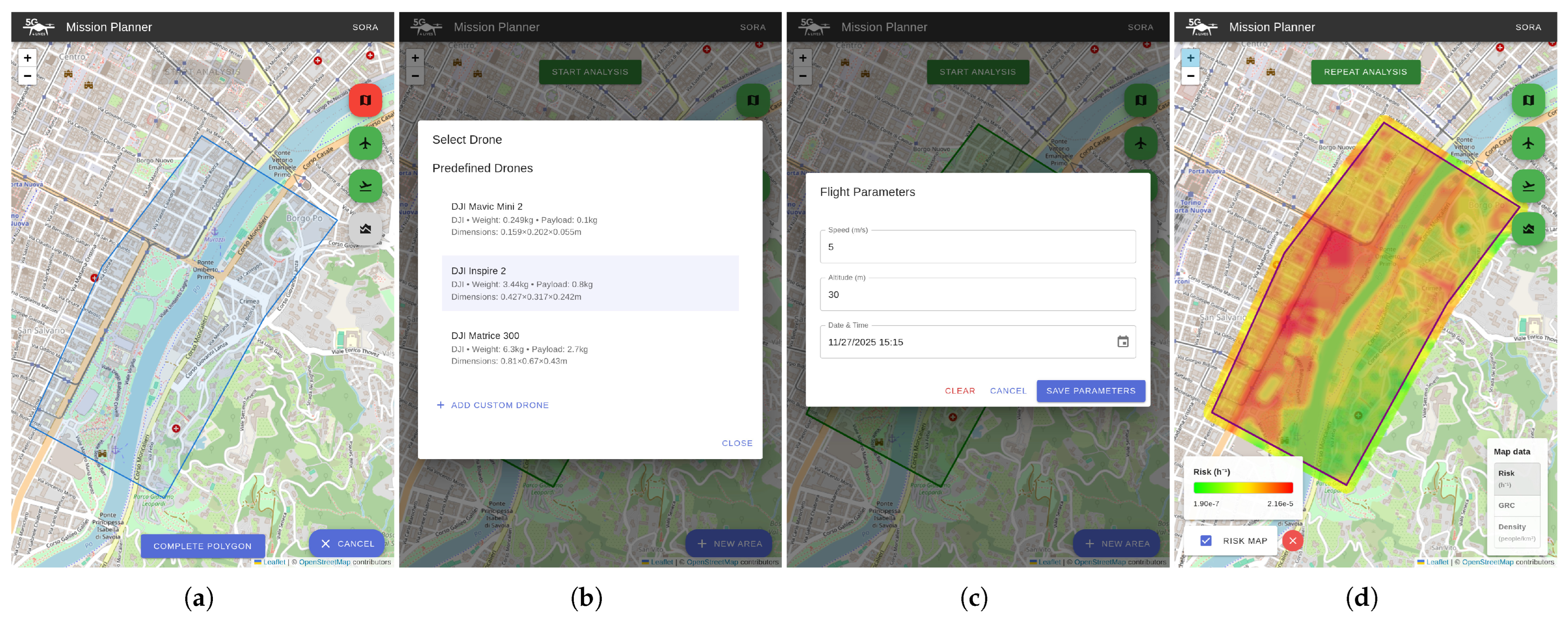
Figure 2,
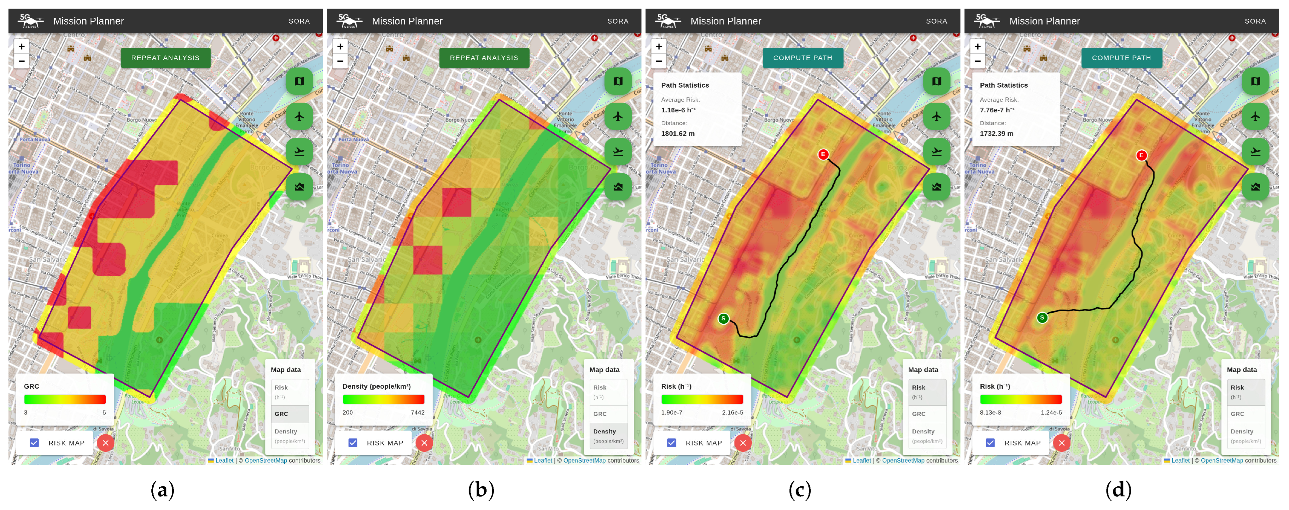
Figure 3 and
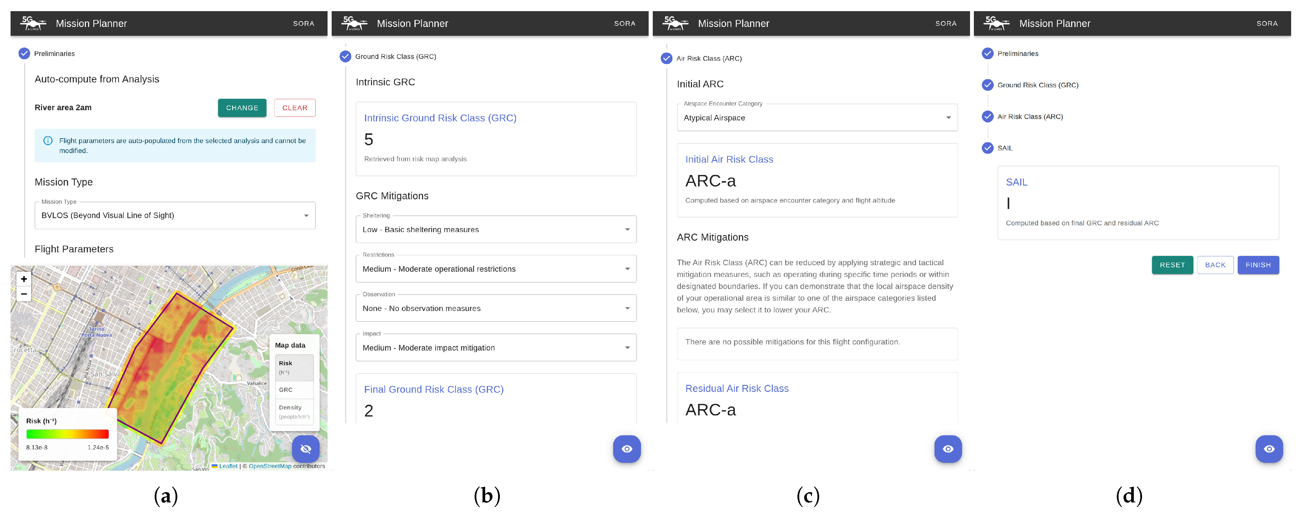
Figure 4 illustrate how the application supports the UAS operator in performing a risk assessment and planning a mission in a representative area of the city center of Turin.
The operator begins by selecting the area of interest, either by drawing a rectangle or by defining a polygon directly on the map (
Figure 2a). Once the operational area is selected, the user can choose a drone platform from a predefined list or specify a custom configuration, including aircraft mass and payload mass (
Figure 2b). This information is essential because payload variations directly influence the resulting ground risk. In the flight-parameter panel (
Figure 2c), the operator can then specify the operational speed, flight altitude, and the estimated date and time of the mission. Based on these inputs, the system computes the corresponding risk map, which is visualized in
Figure 2d.
The web application also allows users to explore different layers of information associated with the selected area. These include the high-fidelity ground risk map (
Figure 2d), the intrinsic iGRC index (
Figure 3a), and the population-density distribution (
Figure 3b). This capability provides operators with clear awareness of how risk is spatially distributed across the operational environment, supporting more informed decision-making.
The operator may then request the computation of a minimum-risk path based on the selected risk map.
Figure 3c shows the path computed using the population-density data corresponding to 3 p.m., resulting in a ground risk value of
, which exceeds the typical ELOS threshold of
. By contrast,
Figure 3d shows the path computed using the 2 a.m. population-density map, when a lower number of potentially affected people is expected. In this case, the resulting minimum-risk trajectory achieves a reduced risk value (below the ELOS threshold), confirming the strong dependence of risk on temporal factors.
These results can be directly used within the SORA workflow.
Figure 4 shows several screenshots of the SORA-related sections of the web app, starting from the page where the operator imports the previously computed high-fidelity analysis, followed by the computation of the iGRC and the definition of ground risk mitigations (
Figure 4b). Subsequently, the operator determines the ARC along with its associated strategic mitigations (
Figure 4c) and finally obtains the SAIL for the mission (
Figure 4d).
This representative use case demonstrates the practical applicability of the web-based tool, showing how it can effectively support UAS operators in risk assessment and mission planning within an urban operational context. Although the current implementation focuses on the evaluation phase of SORA 2.5, this work represents a preliminary step toward a complete end-to-end workflow. Further developments are planned to extend the tool to the demonstration and submission phases [
11], which are not yet implemented in this version.