1. Introduction
With the evolution of our needs and the development of new markets for positioning techniques, decimetre-level accuracy is increasingly considered sufficient for several applications, such as Location-Based Services or maritime navigation, making centimetre-level accuracy less critical in these contexts. Responding to user needs and market trends, Quasi–Zenith Satellite System (QZSS), BeiDou and Galileo constellations have created services to meet them. For example, the Japanese CLAS (Centimetre Level Augmentation Service) [
1] was the first fully operational satellite-based augmentation system of its kind and remains unique in its inclusion of atmospheric corrections. It operates within the same geographical footprint as the QZSS constellation and supports positioning at the decimetre level. Meanwhile, China has developed its own regional PPP solution known as PPP-B2P, which broadcasts correction data for BeiDou and GPS via the B2b signal on BeiDou’s GEO satellites [
2]. This service is intended for users in China and nearby areas and provides positioning performance comparable to that of the QZSS-based system.
Similar to what has been done in Asia, Galileo started its High Accuracy Service (HAS) in January 2023, which provides free PPP corrections [
3]. Thanks to its Medium Earth Orbit (MEO) satellites, HAS is the first high-accuracy service available all around the world. It uses a special encoding method called High-Parity Vertical Reed–Solomon (HPVRS), which helps users to receive the correction signals more reliably from different satellites [
4]. The service has two levels: the first one (SL1), already available worldwide, includes orbit and clock corrections, as well as code and phase biases. However, owing to insufficient accuracy, the phase biases were excluded from SL1. The second level (SL2), planned to become available in the coming years within the European Coverage Area (ECA), will add atmospheric corrections. The expected 95% accuracy is better than 20 cm horizontally and 40 cm vertically. With SL2, convergence time is also expected to be much faster—less than 100 s, about three times quicker than with SL1.
However, in January 2023, the European Union Agency for the Space Program (EUSPA) published the Service Definition Document (SDD) [
5], which lowered the performance targets and reduced the service coverage area for Galileo HAS. The new target accuracy is 15 cm horizontally and 20 cm vertically, but these values apply only to static users and are defined for the 68th percentile, excluding users in the Pacific region.
After a brief overview of the current HAS corrections and their performance, the results of a typical PPP using these corrections are presented. Then, to highlight the benefits of ionospheric corrections and phase biases, their generation and application are demonstrated using a European network of permanent stations. The article concludes with a discussion and some perspectives for future work.
2. HAS Signal-In-Space
HAS provides free PPP corrections for a high accuracy global positioning [
6]. At the time of study, i.e., from April 2023 to June 2023, these corrections are composed of orbit and clock corrections, and code biases for the two frequencies of GPS (L1 and L2C) and four frequencies of Galileo (E1, E5a, E5b, E6). All these corrections are available in real time and are broadcasted through the E6b signal (Signal-in-Space, SiS) and internet. However, in this paper, the focus is only on the corrections coming from the SiS. Currently, because the network includes five uplink stations with four antennas each, a maximum of 20 satellites can transmit the corrections simultaneously. As explained in the introduction, the target accuracy is 15 cm horizontally and 20 cm vertically, for a static user and for the 68th percentile.
To ensure consistency and maintain a clear focus on Galileo HAS corrections, all analyses in this paper are based on HAS corrections applied to combined navigation messages provided by the International GNSS Service (IGS).
Before performing any positioning, the availability and the accuracy of corrections has been evaluated. To assess the availability of HAS corrections, the availability and validity of corrections for each visible satellite for 2592 locations distributed over the world are checked, every 900 s and over the 2 months under consideration. A filtering mechanism was implemented to identify any corrections that exceeded their specified interval of valid values, which are outlined in the Interface Control Document (ICD) [
7]. This check is done after removing satellites flagged as “not usable” by the Galileo Constellation.
For both GPS and Galileo,
Table 1 shows the average number of visible satellites for the 2592 points of the grid and the number of visible satellites having clock and orbit correction. Only the orbit and clock corrections are shown because the availability of the code biases was without interruption. This table shows that the availability of clock corrections is a bit lower than of the orbit corrections. This is due to their validity interval, which is shorter for the clock than for the orbit corrections. Moreover, the difference between the number of visible satellites and the number of satellites having corrections is higher for GPS due to more numerous invalid corrections. However, for GPS and Galileo, the difference is less than one satellite, which demonstrates the high availability of HAS corrections. Moreover, during 99.6% of the time, five satellites with corrections of each constellation are available as an average over the world.
Then, to evaluate the accuracy of the HAS corrections, the corrected broadcast ephemeris has been compared to the final precise ephemeris and clock products provided by the Groupe de Recherche de Géodésie Spatiale (GRG). These products were selected as a reference due to their precision, making them some of the most accurate and reliable options currently available.
Table 2 provides an overview of the accuracy of the products throughout the 2 months, both with and without HAS corrections and for the three orbit components (radial, along-track and cross-track), the clock and the Signal-In-Space Range Error (SISRE), which represent the combined error resulting from broadcast ephemeris and clock offset [
8]. About the ephemeris data, as anticipated due to the update rate (10 min for Galileo against 2 h for GPS), the enhancements are more prominent for GPS. The GPS orbit errors demonstrate reductions of about 86% for every component. While the improvements for Galileo are relatively lower, they still show an improvement from 62% for the along-track component to 72% for the radial component. Concerning clock errors, we can see an improvement with the utilization of HAS, by 46% for GPS and 35% for Galileo. A similar trend is observed for the SISRE.
Now that the impact of the HAS corrections on the broadcast products has been demonstrated, the next section presents the resulting PPP performance.
3. Typical PPP Performance
In this paper the Precise Point Positioning Library (PPPLib) software is used for performing PPP [
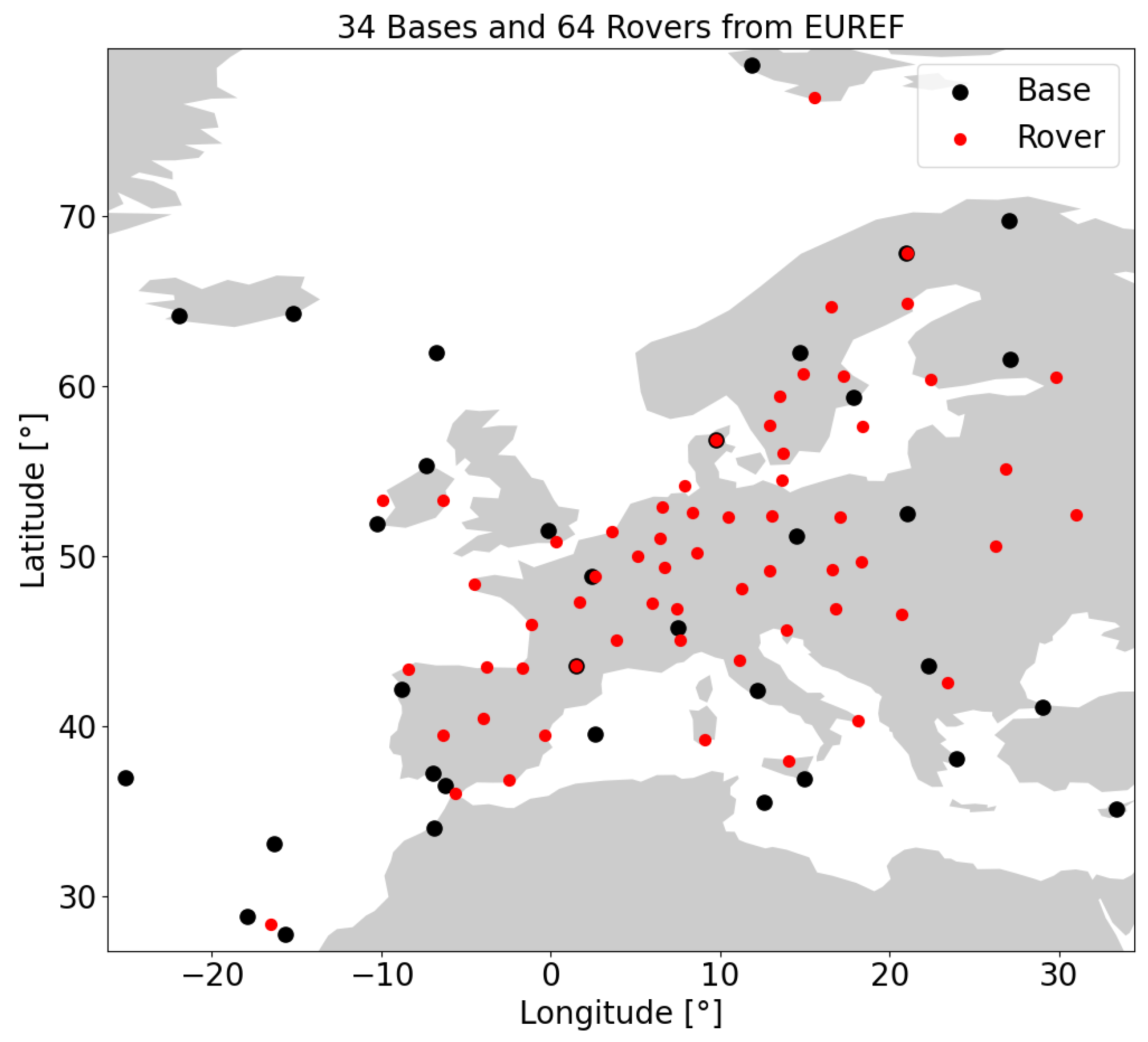
9]. The software is based on a Kalman filter algorithm and the computation is done using a PPP with uncombined L1/L2 (GPS) and E1/E5b (Galileo) code and carrier phase observations with 30s sampling. The used products are the IGS combined broadcast messages corrected with HAS SiS data. In this section, PPP is performed in static mode, meaning that, in the algorithm, the coordinates are considered constant rather than modeled as white noise. Nevertheless, the position is re-estimated at every epoch. The processing is carried out with float ambiguities (only code biases are applied) and without atmospheric corrections, so that both the troposphere and ionosphere are estimated by the PPP algorithm. The evaluated sites are 34 stations from the EUREF Permanent Network (EPN), with sessions of 24 h and from DOY 92 to 153 of year 2023. The network is shown in
Figure 1, as the black dots. It should be noted that the results in this paper are software-dependent and may differ when using another PPP engine.
Table 3 shows the accuracy, over these 34 stations at 68% and 95% and the convergence time at 68%. To remove the impact of convergence on the accuracies, they are computed using only for the last 23 h of the day. The 68% accuracy (respectively, the 95% accuracy) is computed as the quantile at 68% (respectively, at 95%) of the horizontal and vertical error for all the sessions of each station with respect to the IGS weekly estimated coordinates. The table presents the average of this 68% (respectively, 95%) accuracy over all stations. The convergence time is defined as the time needed for the 68% accuracy of each station to reach a threshold (15 cm in horizontal, 20cm in vertical) for at least two minutes. The average of this time for all the stations is shown in the table.
First, we can highlight the achieved accuracy. Under static positioning conditions, HAS achieves a 68% accuracy within 5 cm both horizontally and vertically, with convergence times of about 18 min for horizontal and 10 min for vertical positioning. Compared to the SDD standards rather than HAS’s initial expectations, the results fully meet the required accuracy thresholds. When considering HAS’s initial expectations (20 cm horizontally and 40 cm vertically at 95%), the results meet them too. Regarding convergence time, while the SDD does not provide specific criteria, HAS’s initial targets aimed for convergence within 5 min. This benchmark was not met, despite the excellent positioning results. Given the significant convergence time, the impact of adding ionospheric corrections is evaluated in the following section.
4. Ionospheric Corrections
Once the performance of the current HAS corrections has been demonstrated, we can ask for the future corrections of this service. Thus, ionospheric corrections have been generated, and their impact has been evaluated. For that, 64 rovers, reproducing users, are selected over Europe and among EPN stations (red dots in
Figure 1). The bases, used to generate the corrections, are the 34 stations used in the previous section (black dots in
Figure 1). The rovers are never the same as the bases, but a rover and a base could be collocated. The mean distance between each rover and the nearest base is 314 km. The selected bases were chosen to approximate as closely as possible the future HAS network. Specifically, they correspond to the EPN stations nearest to the European Geostationary Navigation Overlay Service (EGNOS) network, which are the most likely candidates for computing HAS atmospheric corrections. In addition, establishing a local network was required to emulate, as realistically as possible, the configuration that HAS is expected to deliver.
For the bases, the PPP configuration shown in the previous section is used to estimate slant ionospheric delays for each satellite. The HAS products are used to approach real-time applications. Indeed, to generate the HAS corrections and the associated atmospheric data, input products with an accuracy comparable to that of the HAS corrections are utilized. For the rovers, the PPP parameters are similar, except that a kinematic mode is used (i.e., the coordinates are modeled as white noise), and the computation is done with 3 h sessions. To only have converged atmospheric delay, the first nine hours of the day are not used.
The same software, PPPLib, is used but it has been modified to be able to use the ionospheric corrections as constraints, as described in Equations (
1) and (
2), with the estimated slant delays added as measurements. The slant ionosphere delays are estimated for each satellite, with a 30 s rate and with the three nearest bases from the rover with which a simple inverse distance weighted interpolation is performed.
where
is the estimated ionospheric data vector including all ionospheric slant delays for each satellite s. To remove the receiver bias from the STEC, a single difference between each satellite and a reference satellite r is applied. The vector of ionosphere parameters is defined as follows: ;
is the design matrix for the atmospheric data:
;
is the covariance matrix of the atmospheric corrections. As a first step, the variance is set to 1 m2. A test using several variances over the rover network for one day was conducted, showing that these values yield the best results. However, a next step in our algorithm would be to have an adaptive variance, according to the quality of the base or to the distance between the base and the coarse position of the rover.
Table 4 presents the accuracy of the PPP processing with and without ionospheric corrections at 68% and 95%. Accuracy is measured only during the last hour of the sessions. The 68% accuracy (respectively, the 95% accuracy) is computed as the 68th (respectively, 95th) percentile of horizontal and vertical errors across all sessions of each station. The table then reports the average of these 68% and 95% accuracy values across all stations. It also shows the convergence time for 68% accuracy. The table displays the average convergence time across all stations, and the number of rovers that have actually converged is indicated in brackets. The total number of rovers is 64.
First, we observe that ionospheric corrections improve the accuracy of PPP positioning using HAS products. Comparing the horizontal accuracy of PPP without atmospheric corrections to that of a PPP performance with additional ionospheric corrections, we see an improvement of 43% (from 14.6 cm to 8.2 cm) for the 68% accuracy level and 48% (from 30.7 cm to 16.0 cm) for the 95% accuracy level. The improvement is even more significant for the vertical accuracy, with a reduction in error of 47% at 68% and 53% at 95%.
As observed for accuracy, ionospheric corrections consistently improve convergence time. Additionally, by reducing positioning errors, they also increase the number of rovers that achieve convergence. The 68% horizontal convergence time improves by 53% compared to the original process (from 127 min to 58 min), and the number of converged rovers increases from 60 to 64. In terms of vertical convergence time, the results show limited variation, with no noticeable improvement between the two processing approaches.
In conclusion, the ionospheric corrections enable more stations to converge because of the accuracy improvement. Moreover, while the vertical convergence time does not change, the horizontal one is cut by half. Atmospheric corrections are therefore beneficial, even with a sparse network as used in this paper.
5. Satellite Phase Bias
During the test phase, the HAS satellite phase biases were available. Unfortunately, they were not good enough to ensure the HAS target and have been withdrawn before the official opening of the service. However, as for the ionospheric corrections, we tried to generate them and study the behaviour of the PPP positioning with them. To do so, the network shown in
Figure 1 has been used (black dots). From the PPP performed over all the stations, and the estimated ambiguities, the Widelane and Narrowlane have been computed. Single differences between satellites are used to eliminate the receiver phase biases. Then, using the whole network and following the Equations (
3) and (
4), the satellite phase biases
and
on L1/L2 for GPS and L1/L5a for Galileo are estimated. Since the estimation uses orbits from a float solution, the phase biases are of limited quality, which also reduces the performance of ambiguity resolution.
where
and are respectively the estimated Widelane and Narrowlane ambiguities;
and are respectively the integer Widelane and Narrowlane ambiguities;
and are the phase biases for the frequencies and , respectively.
Based on the estimated phase biases, a PPP with Ambiguity Resolution (PPP-AR) was performed. In this section, the PRIDE PPP-AR software [
10] is used instead of PPPLib, as it offers better support for ambiguity resolution. Since PRIDE uses batch processing, it does not provide information about convergence time, which is therefore not evaluated in this section. Aside from the software change, most processing parameters remain similar to the previous test.
The PPP-AR was applied to 64 rover stations, selected from the EPN network (red dots in
Figure 1). The processing uses HAS products to approximate real-time application conditions and ensure consistency across datasets. The computation was performed in kinematic mode over 3 h sessions of DOY 92, year 2023, using uncombined code and carrier-phase measurements on L1/L2 (GPS) and E1/E5a (Galileo) frequencies, with a 30 s sampling interval. As in the previous tests, official HAS code biases, orbit and clock corrections were used, and additionally, the estimated phase biases were applied for PPP-AR.
Table 5 presents the accuracy of the PPP processing with float and fixed solutions at 68% and 95%. As the PRIDE software is working with a batch algorithm, there is no convergence and then, accuracy is measured over the whole session. The 68% accuracy (respectively, the 95% accuracy) is computed as the 68th (respectively, 95th) percentile of horizontal and vertical errors across all sessions of each station. The table reports the average of these 68% and 95% accuracy values across all stations. It also shows the percentage of fixed Widelane (WL) and Narrowlane (NL) for each constellation.
Despite moderate fixing rates (e.g., 63% for Widelane and around 32–33% for Narrowlane) and a few bad fixes that slightly affect certain sessions, the application of ambiguity resolution does not lead to any significant degradation. The fixed solution shows accuracy comparable to the float solution, both horizontally and vertically, at the 68% and 95% confidence levels.
This stability is encouraging and demonstrates that integrating phase bias corrections from HAS does not compromise solution quality. On the contrary, it suggests that even partial ambiguity resolution can be applied without introducing positioning noise, which is highly promising for future real-time PPP-AR applications using Galileo HAS. Ultimately, with improved raw corrections or more robust processing methods, the performance of HAS could benefit further from the use of phase biases. This potential should become more apparent in the coming months with the rollout of the second service level.
6. Discussion and Conclusions
Thanks to HAS, Galileo provides a free and global opportunity to perform PPP anywhere on Earth. The HAS corrections demonstrate high availability, with more than 99% of the time offering access to at least five GPS and five Galileo satellites. They also represent a significant improvement over raw broadcast messages, with a SISRE reduction of approximately 54% for Galileo and 60% for GPS.
The official HAS performance targets are 15 cm horizontally and 20 cm vertically (68% confidence level) for static users. These targets are not only met but clearly surpassed over a European network, where average horizontal and vertical positioning errors remain below 5 cm.
However, these impressive results apply only to static users. In kinematic mode, PPP still shows lower accuracy and, more importantly, relatively long convergence times. To address this, ionospheric corrections—part of the upcoming HAS service level 2—have been generated and tested. Results show that these corrections significantly enhance both positioning accuracy and convergence speed. In fact, the 68% horizontal and vertical positioning errors are halved, and the horizontal convergence time is also reduced by a factor of two.
With the addition of ionospheric corrections, only the phase biases were missing to complete the full HAS service. As was done previously, these phase biases were generated using a European network to evaluate their impact on PPP solutions. The results showed no degradation in performance, which is encouraging for the future of the service. However, it should be noted that the quality of the estimated phase biases is limited (e.g., due to the reliance on float orbits), which constrains their contribution to ambiguity resolution. Nevertheless, with further refinements, HAS could still benefit significantly from these biases and deliver improved positioning performance.
These tests have demonstrated that HAS already provides a substantial improvement over the raw broadcast messages. In the near future, further gains are expected as the system evolves. Nevertheless, additional testing will be necessary once Service Level 2 becomes available. It would also be valuable to assess the full set of HAS corrections, including ionospheric corrections and phase biases, in real-world user scenarios.