Abstract
As traffic accidents caused by black ice during the winter continue to occur, there is a growing need for technologies that enable drivers to recognize and respond to black ice in advance. In particular, to reduce major accidents and associated casualties, it is essential to provide timely information and prevent incidents through accurate prediction. This paper proposes an artificial intelligence (AI) technology capable of detecting and predicting black ice using multimodal data. The study aims to enable a preemptive response in the field of digital disaster safety and discusses the applicability and effectiveness of the proposed approach in real-world road environments.
1. Introduction
Black ice prediction technology typically relies on weather data. However, the commonly used data such as temperature, humidity, wind speed, rain, and snow is usually collected from highways and is often far away from the Expressway section being analyzed. Weather conditions can change rapidly in areas like shaded mountainous zones, and these environmental variations can significantly degrade prediction accuracy. Therefore, it is essential to obtain road-specific meteorological data and generate input data by calibrating the collected weather information according to the topography and road environment of the prediction location [1,2].
For early prediction, it is essential that artificial intelligence can recognize the initial signs of black ice formation. However, relying solely on basic meteorological data as input is insufficient for sensitively detecting the early changes on the road surface caused by black ice. Therefore, an AI model based on multimodal data that integrates various active data sources is required to improve both sensitivity and prediction accuracy [3,4].
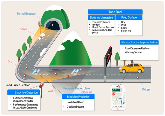
As shown in Figure 1, technologies related to black ice detection and prediction have predominantly been developed and validated within simulated environments. Real-world applications remain largely limited to basic field deployments, resulting in low reliability of the derived outcomes. Consequently, the objective accuracy of these approaches remains uncertain, underscoring the need for systematic demonstration and validation to improve both technological maturity and predictive performance.

Figure 1.
Black ice detection and prediction concept.
This study focuses on the development of an artificial intelligence technology capable of detecting and predicting black ice at an early stage using multimodal data, as well as the implementation and demonstration of a digital disaster safety platform for preemptive response.
2. Research Trends Related to Black Ice
As illustrated in Figure 2, a machine learning model utilizing the random forest algorithm was developed to estimate winter road surface conditions. This model leverages data collected from roadside weather sensors and CCTV video imagery. Additionally, a long short-term memory (LSTM)-based AI model was proposed to predict road surface temperatures at various time intervals by utilizing the time-series characteristics of meteorological data.

Figure 2.
Black ice prediction.
The imaging sensor WIDE SENSE enables the acquisition of short-wave infrared (SWIR) spectral data, which can distinguish between ice and water layers on road surfaces, thus allowing accurate and continuous monitoring of road conditions (Italy).
Grip is a system designed to detect black ice by analyzing information collected from in-vehicle sensors and estimating the road surface friction coefficient in real time (Finland).
A prediction model for black ice occurrence on national expressways was developed by collecting weather data and road location information. Additionally, a black ice prediction model was developed by incorporating system dynamics concepts and utilizing black ice-related data together with road GIS information.
A road icing probability estimation model was developed by equipping regular patrol vehicles with temperature sensors to measure both ambient air and road surface temperatures, using the temperature difference as a key variable (KICT).
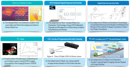
As illustrated in Figure 3, a system titled “Black Ice Detection Method and System Using the Same” was developed to improve detection reliability by implementing dual-sensor detection of black ice on road surfaces. This approach utilizes both LiDAR and thermal imaging cameras to enhance the accuracy and robustness of black ice identification.

Figure 3.
Black ice detection.
A black ice detection technique utilizing non-contact GPS signal reflections was developed, along with ongoing research aimed at minimizing the effects of environmental factors and signal noise.
Additionally, a black ice detection technology using beamforming array radar combined with reflectors was developed to measure variations in the dielectric constant caused by phase transitions between water and ice on road surfaces.
3. Contents of the Research
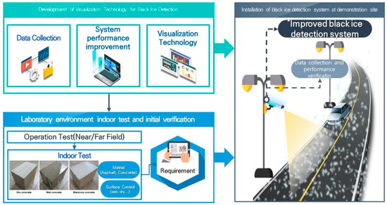
As shown in Figure 4, this research and development initiative aims to develop an artificial intelligence (AI)-based system for the early detection and prediction of black ice through the integration of multimodal data sources. These sources include meteorological sensors, CCTV video feeds, vehicle-mounted sensor data, and geographic information system (GIS) data. The fusion of these heterogeneous datasets facilitates more accurate and timely assessment of road surface conditions conducive to black ice formation.

Figure 4.
Black ice detection and prediction concept.
To overcome the limitations of existing black ice detection systems—which are often confined to simulation environments or provide only generalized risk information—this project aims to develop a real-time, field-deployable solution. By employing machine learning techniques such as random forests, long short-term memory (LSTM) networks, and system dynamics modeling, the project seeks to construct robust prediction models that account for both temporal and spatial variability in weather and road conditions.
Furthermore, the project will implement a digital disaster safety platform designed to facilitate proactive responses by delivering tailored alerts and risk assessments to both road operators and drivers. This platform will support decision-making by providing real-time road status updates and risk forecasts up to 60 min in advance.
4. Test Bed Construction
Most technologies related to black ice detection have demonstrated accuracy only under ideal or laboratory conditions, and their deployment in real-world road environments has typically been limited to basic applications without comprehensive validation procedures.
Technologies that have not undergone proper field verification have reliability issues and are often utilized merely as reference materials. Consequently, these technologies cannot be effectively integrated into existing road operation platforms or utilized in practical response processes.
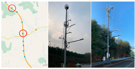
As shown in Figure 5, an experimental scenario simulating realistic driving conditions was constructed using test roads situated adjacent to operational expressways, such as the Yeo-ju Test Road in Korea. The scenario incorporated application modules specifically tailored to the varying pavement types present within the test area, thereby enhancing the representativeness and applicability of the evaluation environment.

Figure 5.
Yeo-ju Test Road (Korea Expressway).
A total of 32 weather-related parameters are received every minute, including wind direction, wind speed, temperature, humidity, atmospheric pressure, rainfall detection, rainfall correction, road condition, and road surface temperature.
5. Conclusions
To ensure practical applicability and reliability, the proposed technologies will be tested and validated through field demonstrations in black ice-prone areas such as tunnel exits, shaded mountainous roads, curved sections, and intersections. The ultimate goal of this project is to enhance road safety by minimizing black ice-related accidents and enabling timely, data-driven interventions.
This research is expected to contribute to strengthening the competitiveness of domestic winter road management technologies by developing early black ice prediction techniques based on accurate detection within the target area and road surface condition forecasting.
Based on the predicted risk level and evaluation of the black ice prediction model’s performance over different time intervals, optimal information and countermeasures can be proposed. This will support the development of AI-driven, decision-support technologies led by road managers.
Author Contributions
Project administration and writing—original draft preparation, S.-I.K.; writing—review and editing, Y.-S.S. All authors have read and agreed to the published version of the manuscript.
Funding
This work was supported by Korea Planning & Evaluation Institute of Industrial Technology funded by the Ministry of the Interior and Safety (MOIS, Korea) [Project Name: Development of Early Detection and Preemptive Response Technology for Black Ice Using Multi-modal Imaging; Project Number: RS-2024-00409314].
Institutional Review Board Statement
Not applicable.
Informed Consent Statement
Not applicable.
Data Availability Statement
Data are available in this manuscript.
Conflicts of Interest
The authors declare no conflict of interest.
References
- Jeong, M.C.; Lee, J.H.; Oh, H.Y. Ensemble machine learning model-based YouTube spam comment detection. J. Korea Inst. Inf. Commun. Eng. 2020, 24, 576–583. [Google Scholar]
- Kim, J.Y.; Lee, H.J.; Paik, J.R. Survey on distinction of black ice using sensors. J. Korea Soc. Comput. 2020, 28, 78–87. [Google Scholar]
- Zheng, M.; Wu, S.; Wang, C.; Li, Y.; Ma, Z.; Peng, L. A Study on Evaluation and Application of Snowmelt Performance of Anti-Icing Asphalt Pavement. Appl. Sci. 2017, 7, 583. [Google Scholar] [CrossRef]
- Park, G.Y. A case study on meteorological analysis of freezing rain and black ice formation on roads in winter. J. Environ. Sci. Int. 2017, 267, 827–836. [Google Scholar]
Disclaimer/Publisher’s Note: The statements, opinions and data contained in all publications are solely those of the individual author(s) and contributor(s) and not of MDPI and/or the editor(s). MDPI and/or the editor(s) disclaim responsibility for any injury to people or property resulting from any ideas, methods, instructions or products referred to in the content. |
© 2025 by the authors. Licensee MDPI, Basel, Switzerland. This article is an open access article distributed under the terms and conditions of the Creative Commons Attribution (CC BY) license (https://creativecommons.org/licenses/by/4.0/).