1. Introduction
The development of mitigation strategies at the urban scale has been one of the most topical issues faced by seismic countries in recent years. Indeed, while the criteria for resisting seismic excitation are well known and the technical codes are adequate and updated, it is not easy to provide the due strength to a large number of existing buildings. This problem is even more relevant for historical buildings since they cannot simply be replaced and their enhancement requires expensive interventions not manageable by private homeowners.
In recent years, many strategies to reduce seismic vulnerability at the urban scale have been developed [
1,
2,
3,
4,
5,
6,
7,
8,
9,
10,
11,
12]. One of the most reliable criteria to set the interventions is based on “damage scenarios” [
13,
14], which provide a rough assessment of the consequences of eventual seismic events, suggesting the primary choices to make. The adoption of damage scenarios to European countries has been introduced by the project RISK-UE (2001–2004), as a consequence of the International Decade for Natural Disaster Reduction 1990–1999 (IDNDR), to promote proper territory planning focused on risk reduction [
4].
The expected damage at the urban scale, along with the communities’ resilience, can be assessed as a function of various parameters, such as the cost of the reconstruction or the lack of functionality of the system [
15]. However, the damage scenarios in specific areas are strictly related to the buildings’ properties since the seismic hazard of the area is usually known, even though the site effects [
16] can affect the local amplification of the seismic acceleration. The most common approach for assessing seismic vulnerability at the urban scale consists in classifying the urban constructions according to some basic macro-parameters, selected as crucial for their seismic response [
17]. Such a classification cannot be carried out without losing some information and eventually neglecting important details.
In Italy, there are over 12 million residential buildings. Currently, the available systemic information is provided by ISTAT (Italian National Institute of Statistics) surveys, which are made periodically and are limited in their information, such as the number of floors, the date of construction, and the structural material. Furthermore, these data are not fully reliable since they have been collected by unqualified personnel. The first statistical analysis on the data collected by ISTAT in 1991 was made by Meroni et al. [
18]. Further analyses were then made based on more detailed data, appositely collected but limited to a much smaller sample.
Recently, the research organization ReLUIS, together with the Civil Protection Service, promoted a research task focused on the classification of residential buildings. The project, named CARTIS [
3], is aimed at achieving a reliable classification of the building population based on a limited number of consistent parameters to assess their seismic vulnerability on the urban scale. The town is assumed to be divided into homogeneous zones made of buildings with “similar” properties. The adopted classification is made according to proper forms, appositely set, consisting of four sections: (i) the zone map, (ii) the building type of each zone, (iii) the main properties of each building type, and (iv) its structure.
This work focuses on the seismic vulnerability of the buildings’ population of Florence and includes the assessment of emergency scenarios at the occurrence of seismic events.
Tuscany is one of the most careful Italian regions with regard to seismic risk. In 2020, it passed a regional law [
19] that mandates all towns to consider seismic vulnerability at the urban scale in their city plans. This research is aimed at assessing the seismic vulnerability of the residential buildings of Florence by checking their damage level and estimating the loss, in terms of destruction and recovery time, related to possible seismic emergencies. The analysis is made by assuming two datasets: one that is more “basic” (i.e., limited to the ISTAT information) and another that is more detailed (implemented by the authors based on further sources). The basic dataset is applied to the entire building population of Florence, whilst the implemented one is applied to a limited area only. In both cases, the damage scenarios forecasted by the two methods have been compared and discussed. In the analysis made on the detailed dataset, two seismic intensities, consistent with the “life safety” and “collapse prevention” limit states, have been considered, and the consequent emergency scenarios have been discussed in terms of the resilience curve and the inhabitants’ evacuation.
2. Strategies for Assessing Urban Vulnerability and Damage Scenarios
Seismic vulnerability at the urban scale can be assessed according to various approaches, which can be classified [
1] as a function of their main properties. Corsanego [
20] suggested a classification based on the type and method of prevision, i.e., direct, providing a damage prevision without the use of any special parameters; indirect, providing a damage prevision through vulnerability factors; and conventional, providing a vulnerability index without any damage prevision. Another effective method of classification distinguishes the quality of the prevision (i.e., if the estimation is quantitative or qualitative only). Further classification can be made on the quality and the source of the information used for the sample description, which can be collected through multisource data [
21], statistical surveys, seismic analyses, expert judges, or direct observations and hybrid techniques.
In many cases, however, the prevision models have been set based on the effective seismic response of real buildings that have experienced earthquakes with known intensities. At the base of the classification, therefore, there is a survey of an extensive sample of buildings hit by ground motions; both the buildings and the damage are classified based on effective parameters, and a relationship is proposed between the geometrical and mechanical properties of the buildings and the damage assumed to be compatible with the seismic events. Four main approaches deserve to be mentioned, since they are at the base of most research:
- -
Based on the European macro-seismic scale of intensity (EMS-98, [
22]);
- -
The macro-seismic methods derived by the EMS-98;
- -
Through matrices of damage probability;
- -
Based on the
Gruppo Nazionale per la Difesa dei Terremoti (GNDT) forms [
23,
24].
The EMS-98 was established in 1998 as a development of former seismic scales, i.e., the Mercalli scale, introduced in 1902, and the MSK, respectively proposed in 1964, 1976, and 1981. Each of them stated the level of damage based on observed phenomena caused by the seismic excitation. The knowledge of the damage level experienced by the buildings upon the occurrence of specific (and known) ground motions led to link damage and seismic intensity for various types of buildings [
25]. This approach proposes six vulnerability classes (VCs) related to 15 building types (including both masonry and reinforced concrete, RC, ones), to the state of conservation, to the structural features, and specifically to the compliance with seismic regulations.
The macro-seismic method was derived from the EMS-98 approach by Giovinazzi and Lagormasino [
22,
26] by introducing some vulnerability indices related to the building type and to specific descriptors, such as the conservation state, the building features, the position within the aggregate, and the existence of anti-seismic devices. This method entails ascribing a vulnerability rating based on assigned macro-clusters.
The matrices of damage probability have been used in Italy since 1982, when Braga et al. [
27] analyzed the damage after the Irpinia earthquake. The study involved 36,000 buildings located in 41 towns and provided a consistent relationship between building types and the level of damage.
The GNDT forms were introduced by Benedetto and Petrini (1984) to check the vulnerability index of a building as a function of some meaningful parameters, and they have been adopted by the National Group for Earthquake Defense (GNDT). The most effective form (level II GNDT form) consists of 11 parameters appropriately selected for RC and masonry buildings, which have to be assessed according to highly detailed criteria. The procedure has been validated by comparing the provided previsions to the observation of the effects of various ground motions that occurred in Italy in the last few decades. The vulnerability index can be found as the weighted sum of the score given to each of the 11 parameters according to precise instructions provided by the authors.
Alternative forms have been recently set for specific types of buildings in order to enable a quick collection of data. The Rapid Visual Screening (RVS) methodology [
28] provided consistent results based on experts’ judges, which are related to proper safety index values. The reliability of the RVS approaches is related to the homogeneity of the buildings’ sample, which leads to representing its mechanical properties through a limited number of parameters.
Once the seismic vulnerability has been assessed, a further step of analysis has to be pursued, consisting in relating the vulnerability of the building with its consequent damage level. Such an assessment can be made based on fragility curves and damage matrices, which can be considered complementary instruments for assessing urban vulnerability.
In this work, the EMS-98 and the macro-seismic approaches have been adopted and compared. Namely, both methods have been applied to the residential buildings of the whole town by adopting a basic (i.e., with a low amount of information) dataset. Furthermore, a comparison between the two methods has been made in a single micro-area by adopting a more exhaustive dataset.
3. Case Study: Florence
3.1. Residential Asset of Florence
3.1.1. Brief History of the Residential Asset of the Town
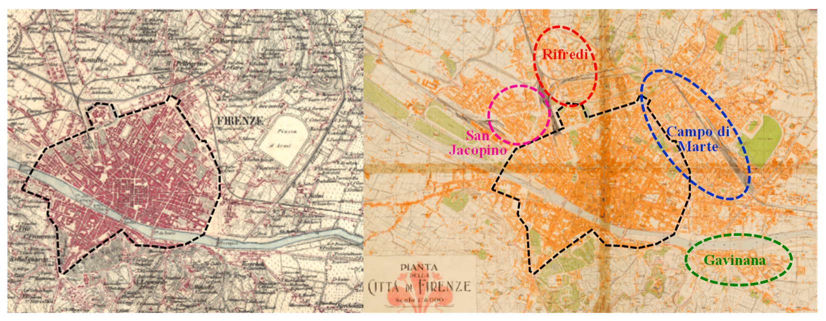
Most of the residential buildings in Florence were constructed before the seismic classification of the town, which occurred in 1982. In the nineteenth century (between 1865 and 1871), Florence was the capital of the Regno d’Italia, experiencing a radical transformation, i.e., the edification of several new buildings and a considerable change in its urban asset [
29]. Most of the new buildings were erected in the neighborhoods north and east of the ancient urban core, as can be seen in
Figure 1.
After the transfer of the capital from Florence to Rome [
30], the edification activity ceased until the first decades of the twentieth century. The recovery of industrial activities after the First World War induced the construction of residential buildings for workers in specific areas of the town (San Jacopino, Campo di Marte, Gavinana, and Rifredi), as evidenced in
Figure 1.
In this period, the construction activity was disorganized and unplanned since the urban plan was passed only in 1924, and this worsened after the Second World War. In the 1960s, numerous residential buildings were erected, located in the peripherical neighborhoods of Florence. The lack of effective planning was hardly contrasted by various urban plans passed in 1951, 1958 (supervised by Giovanni Michelucci), 1962 (Piano Detti), and 1987. Nowadays, Florence presents a residential scenario completely different from the historical core of the town, with most residential buildings in the peripheral areas of the town being constructed in the last century.
3.1.2. Current Information on the Building Population
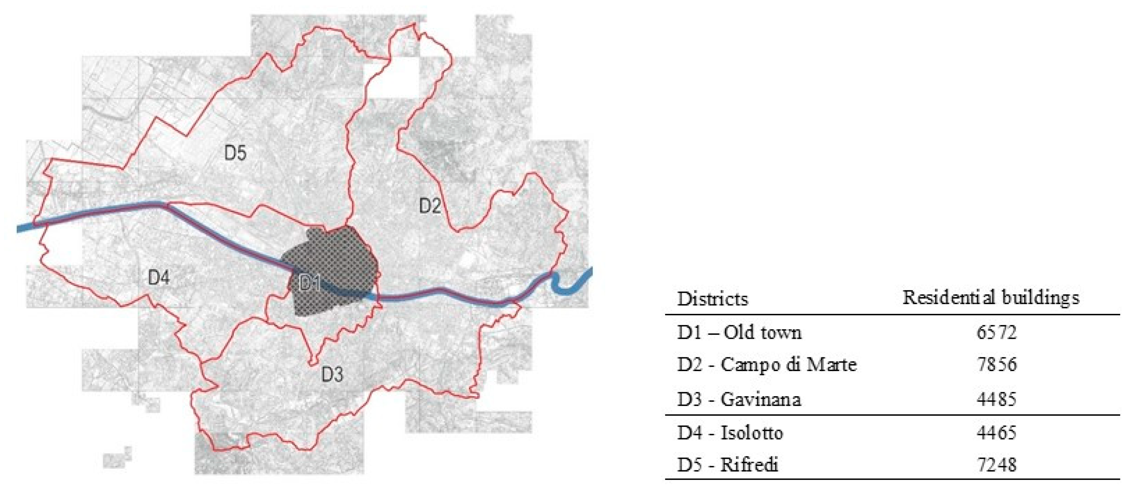
The town of Florence is divided, for administrative purposes, into five districts, shown in
Figure 2. The information used in this section for describing the building population is provided by ISTAT, which conducts periodical population censuses; the last census was made in 2011 [
31]. The residential buildings make up a large majority (82.6%) of the town. They are mostly made via masonry, whilst only a small part is made with RC. Most of the residential buildings (96%) in Florence were made before 1982 (i.e., the year of the seismic classification of the town); therefore, they were made without any anti-seismic criteria.
This work focuses on the residential buildings only; it includes all the buildings of the town, with the exception of the historical heritage site protected by UNESCO, i.e., the area inside the ancient walls of Florence (represented as filled in
Figure 2), which is the object of the National Research Project PRIN 2015, entitled “Mitigating the impacts of natural hazards on cultural heritage sites, structures, and artefacts” (MICHe project, [
6]). The sample belonging to District 1 considered in the analysis, therefore, consists of only 1459 buildings.
3.2. The Seismic Hazard
3.2.1. The Seismic Hazard of the Area
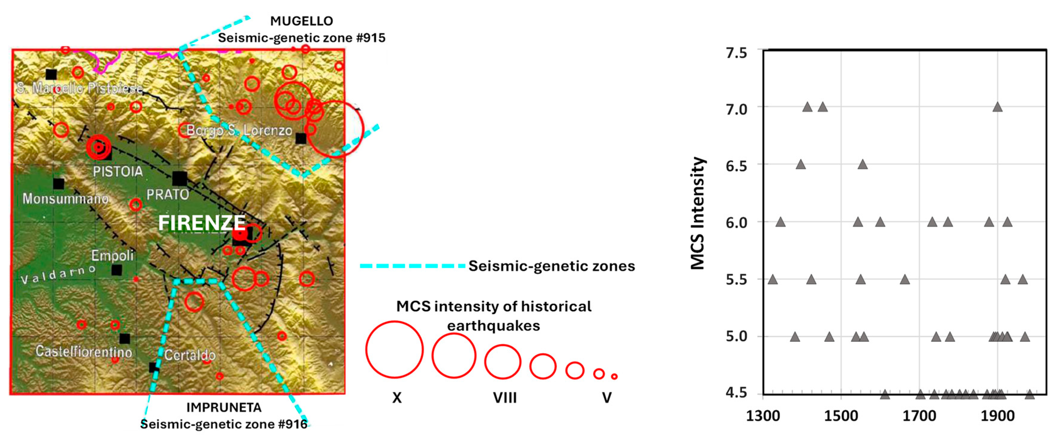
The Florentine area has a sedimentary base that originated in the Late Pliocene [
32,
33]. The deposits can be divided into three typologies: the synthem of the basin, ancient Arno river deposits, and recent Arno river deposits. The area is subjected to two different seismic-genetic zones (see
Figure 3). The first one (#915), located in Garfagnana and in Mugello areas, has a high potential (until M = 6.5) and mostly affects the areas around Florence, whilst the second one (#916), located in Impruneta, is less dangerous (until M = 5.45) but closer to the town.
The area is characterized by moderate telluric activity; it has been classified as a “seismic area” since 1982, and it belongs (according to the Italian seismic regulations) to zone 3, having medium–low seismicity, with ground acceleration between 0.05 g and 0.15 g. The most severe historical earthquakes have been estimated at 5 ML (VII–VIII MCS level), and their epicenters were located around Florence (Mugello 1542 and 1919, Impruneta 1456 and 1895, and Valdarno 1770).
Figure 3 shows the strongest (MCS intensity over 4.5) historical earthquakes that occurred in the area; such information has been provided by a catalog of historical earthquakes [
34] with fair reliability on those that occurred since the tenth century and very good reliability on those after the sixteenth century.
The seismic classification of Florence was made after the damage induced by the earthquakes that occurred in 1895 and 1919. According to the current Italian Technical Code [
35], the peak ground accelerations (PGAs) of Florence, with reference to the standard limit states and the respective return periods, are listed in
Table 1. When the historical seismicity—i.e., the strongest experienced ground motion—is known, the value of the PGA can be associated with the macro-seismic intensity (Im) by following the procedure proposed by Margottini et al. [
36]. The Im values corresponding to the seismic limit states of Florence are listed in
Table 1.
In this analysis, the considered PGA values corresponding to the “life safety” and “collapse prevention” limit states have been assumed to be equal to 0.1089 g and to 0.1796 g, respectively, to be consistent with the macro-seismic intensities Im = 7 and Im = 8, respectively.
3.2.2. The Seismic Micro-Zonation (SM)
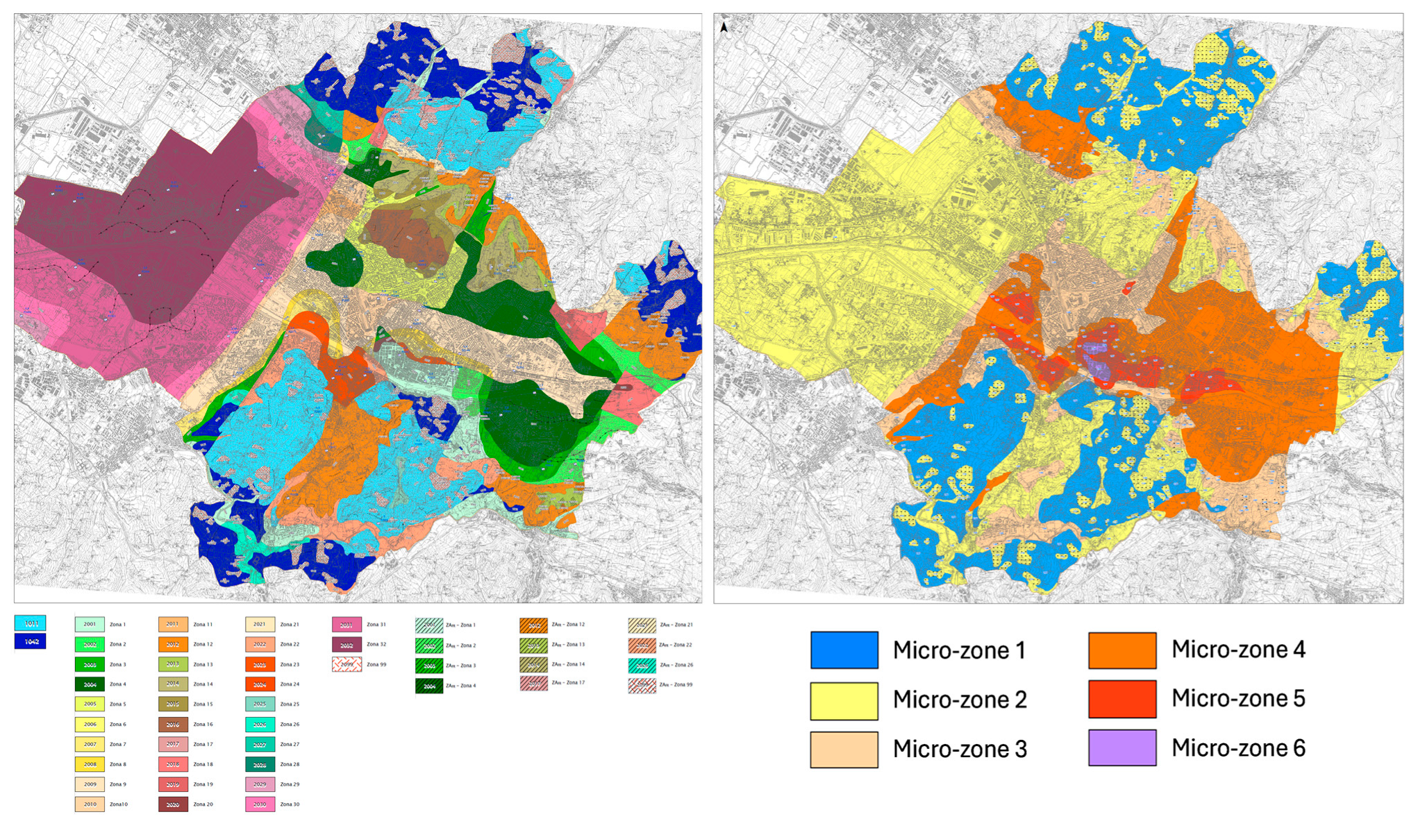
The town of Florence has achieved advanced knowledge of the seismic behavior of its soil [
15]. In recent years, more than 2000 drillings of the soil have been made, implemented by 52 downhole tests. These tests have permitted the definition of a mapped grid with the main subsoil information, such as the fundamental period of the soil, the amplification factor, the bedrock depth, and the stratigraphy. Currently, both seismic micro-zonation (SM) levels I and III are available (see
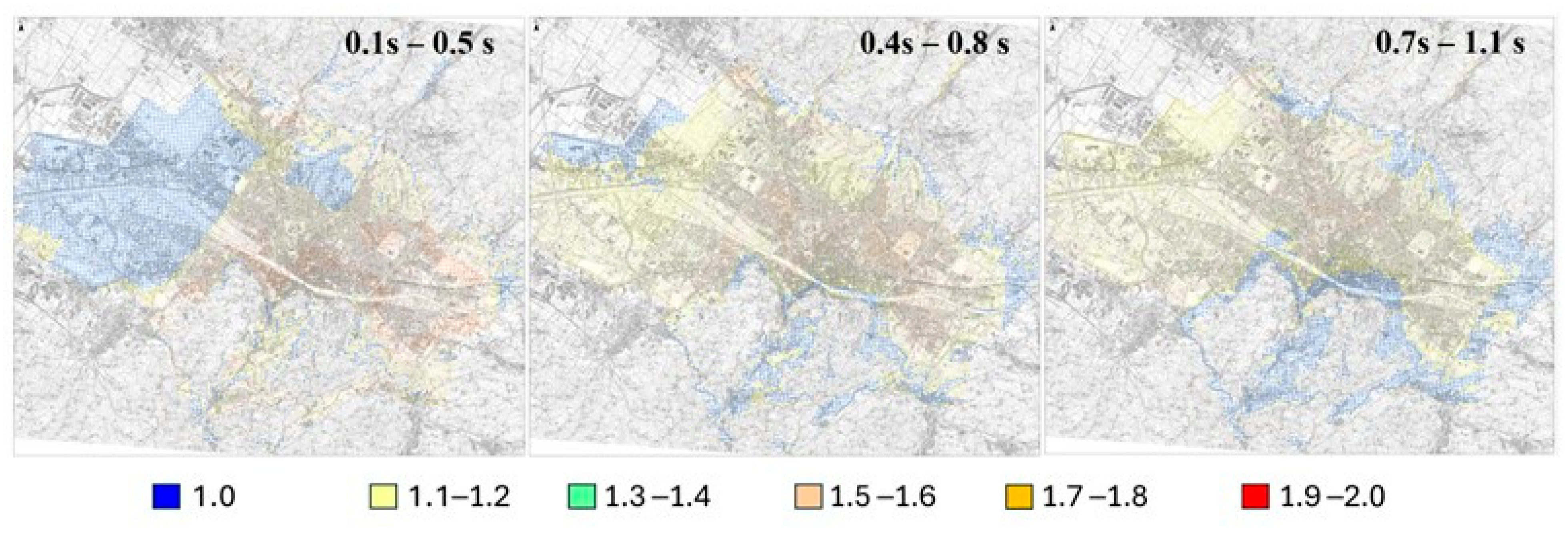
Figure 4). The latter defines the amplification factors (Fas) for three ranges of periods that can be related to the buildings’ height.
According to the performed analyses, the Fa values found for periods between 0.1 s and 0.5 s are consistent with buildings with up to five floors; those found for periods between 0.4 s and 0.8 s are consistent with buildings having five to eight floors; and those found for periods between 0.7 s and 1.1 s are consistent with taller buildings. In
Table 2, the main values of Fa in the selected micro-zones are listed, while further details can be found in the work of Paoletti [
37].
In
Figure 5, the Fa maps found for the three period ranges are shown. In the analysis, the amplification factors have been used for mapping the hazard level. Such detailed seismic hazards, combined with the vulnerability class of the buildings, led to assessing the damage level of the buildings’ sample.
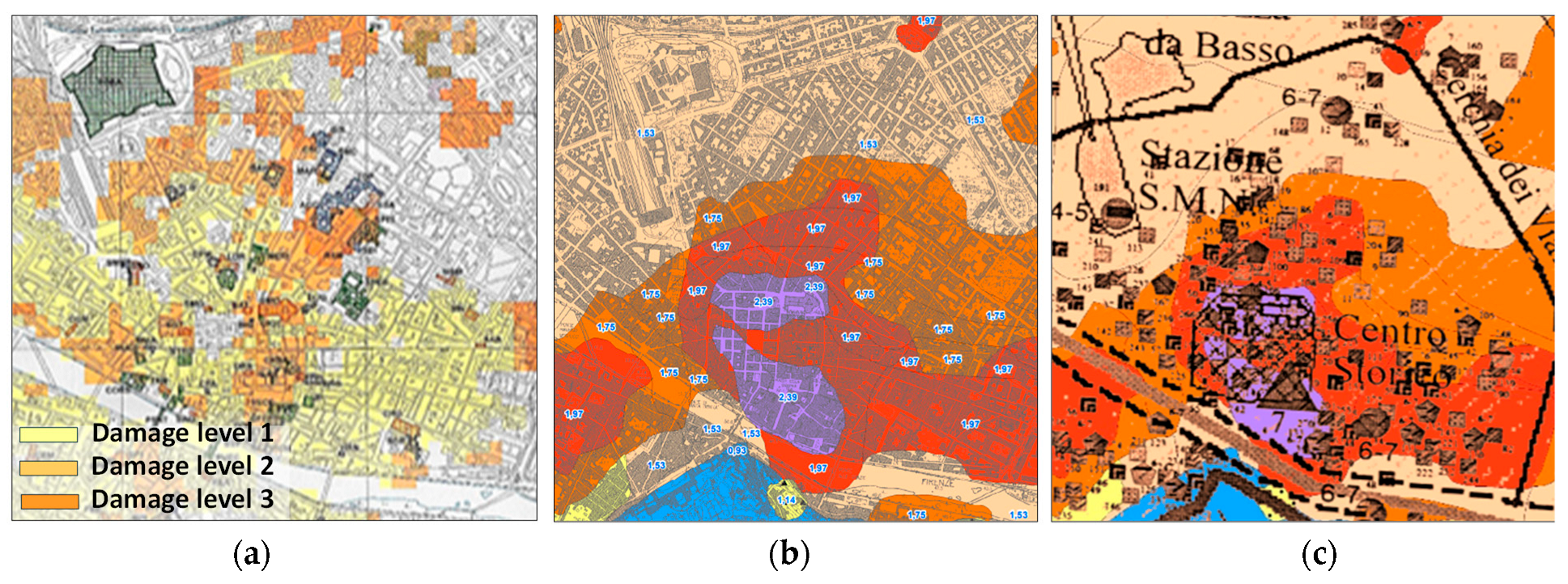
Figure 6 shows the comparison between the damage distribution caused by the 1895 earthquake and the level III seismic map (soil period between 0.1 s and 0.5 s).
4. Building Database and Methods of Analysis
4.1. The Dataset
The reliability of the methods presented in
Section 2 is strictly related to the adequacy of the database selection and to its proper classification. In this work, the building database has been collected by various sources, such as the following:
- -
ISTAT, which collected systemic information on height, age, structural material, and number of inhabitants;
- -
Open data of the Tuscan region and the Florence municipality;
- -
GIS (Geographic Information System) databanks.
One of the problems faced in this phase has been the heterogeneity of the information quality provided by each database; some of the data, indeed, were not precise or were incomplete. The whole database, therefore, has been the object of a particular check to remove eventual mistakes and to confer homogeneity to the data. To work with reliable data, two datasets have been developed (see
Table 3).
The first one refers to the ISTAT databank only; it concerns the entire building population of Florence and consists of little information: the date of construction, the type of structure (masonry, M, versus reinforced concrete, RC), and the number of floors. In the second dataset, the data provided by ISTAT have been integrated with the GIS databank and the metadata provided by the municipality, with a further in situ check made by the authors. This dataset is much more detailed, including further parameters such as structural irregularity, state of preservation, position within the aggregate and aseismic devices. Furthermore, the dataset led to describing the seismic input as a function of the amplification factor, found after the level III seismic map.
The collected information has been used to extract the parameters for the buildings’ characterization. As a result of this classification, 10 macro-clusters have been pinpointed, as described in
Table 4, and used to perform the analyses.
It must be noted that the most refined dataset does not cover the entire town of Florence but is limited to some micro-areas. Therefore, the analysis has been performed with reference to both the whole town, using the basic (ISTAT) data, and some further micro-areas (with reference to the more detailed dataset). In this paper, for the sake of brevity, the results found by adopting the more refined dataset are presented for one micro-area only; further results can be found in [
37].
4.2. EMS-98 and Damage Scenarios
The damage scenarios of the residential buildings have been found through the EMS-98 approach by assuming a macro-seismic intensity (Im) equal to VII, which corresponds to the “life safety” limit state of the area. The PGA has been assumed to be equal to 0.1089 instead of 0.131, as provided by the code (NTC 2018), to have the same seismic intensity for the two performed analyses.
The VC, shown in
Table 5, has been given to each cluster based on the analysis made by Grünthal [
28], which proposes a classification according to the type of structure and its most probable mechanical properties.
Even the correspondence between the VCs and the expected damage level under the assumed seismic intensity has been given according to the instructions provided by Grünthal [
25].
Table 6 shows the description of each VC as a function of the damage level for the EMS-98 method.
The same table shows the correspondence to the damage level assumed by the AeDES forms [
23,
24], provided by the Italian Civil Protection Service to detect the damage caused by earthquakes. The AeDES classification cannot be considered perfectly consistent with the EMS-98, since it is adopted to account for post-seismic damage. However, it has been extensively applied to the Italian building population; therefore, it has been largely tested, and it provides even the recovery times associated with each damage level, which will be used for representing the emergency scenarios.
4.3. Macro-Seismic Method
The macro-seismic method, apart from considering the general properties of each examined macro-cluster, accounts for specific properties of each building in terms of “modifiers” of its seismic response. Their values have been assumed according to the instructions provided by Giovinazzi and Lagormarsino [
22]. In the classification, the plan irregularity refers to convex or concave geometry and indentations over 5%, and the masonry aggregates have been assumed without any seismic joints. The vulnerability levels found for each macro-cluster are listed in
Table 7, which shows the modifier accounted for each macro-cluster, as well as the mean expected vulnerability levels, together with the corresponding minimum and maximum values provided by Giovinazzi and Lagomarsino [
22].
In our analysis, the seismic demand assumed for the assessment has been defined according to the amplification factors provided by the level III soil map by considering the soil period consistent with the building one, roughly assumed as a function of the building height.
5. Analysis
5.1. Analysis of the Whole Urban Buildings’ Population
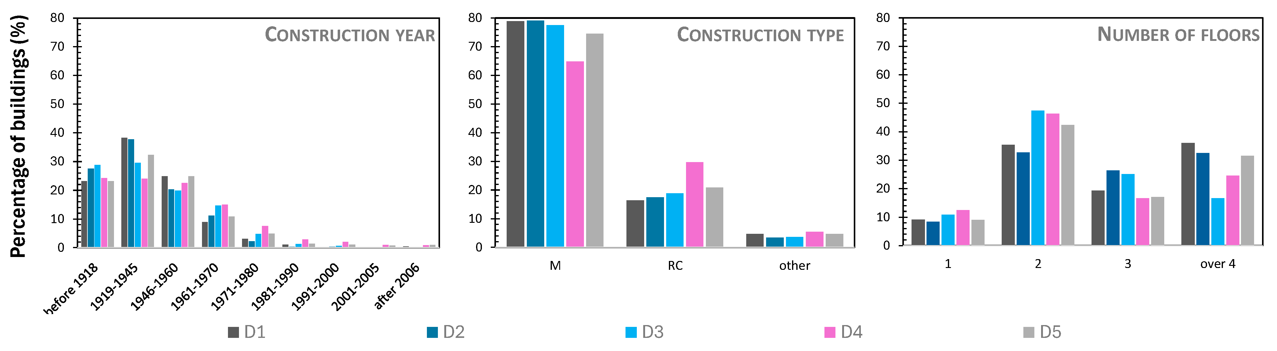
Figure 7 shows the description of the first dataset with reference to the construction year, the structural type, and the number of floors.
The damage level achieved by the buildings’ sample has been attained through the fragility curves of the various constructions’ types [
39,
40,
41]. The assessment of the probability of the occurrence of each damage level, together with the associated seismic intensity, led to assuming the damage level related to each macro-cluster.
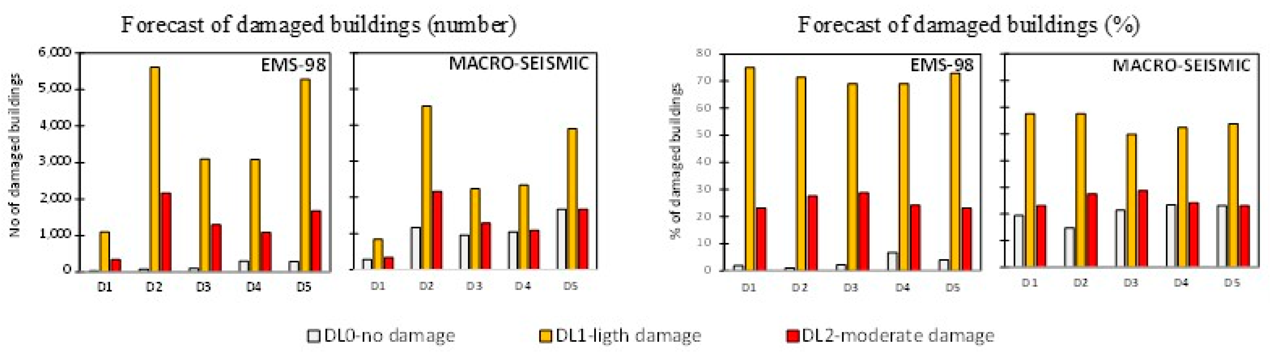
Figure 8 shows the results in terms of the number and percentage of damaged buildings provided by the two methods. As can be noticed by the plots, the two methods provide damage scenarios slightly different from each other, especially for damage levels (DLs) 0 and 1. Indeed, the macro-seismic method allocates a larger amount of buildings on DL0, whilst the EMS-98 provides a larger assessment of DL1. The two approaches instead provide identical previsions for DL2.
The comparison between the two sets of results has been checked in terms of the ratio between the results provided by the EMS-98 and the corresponding results provided by the macro-seismic method, as shown in
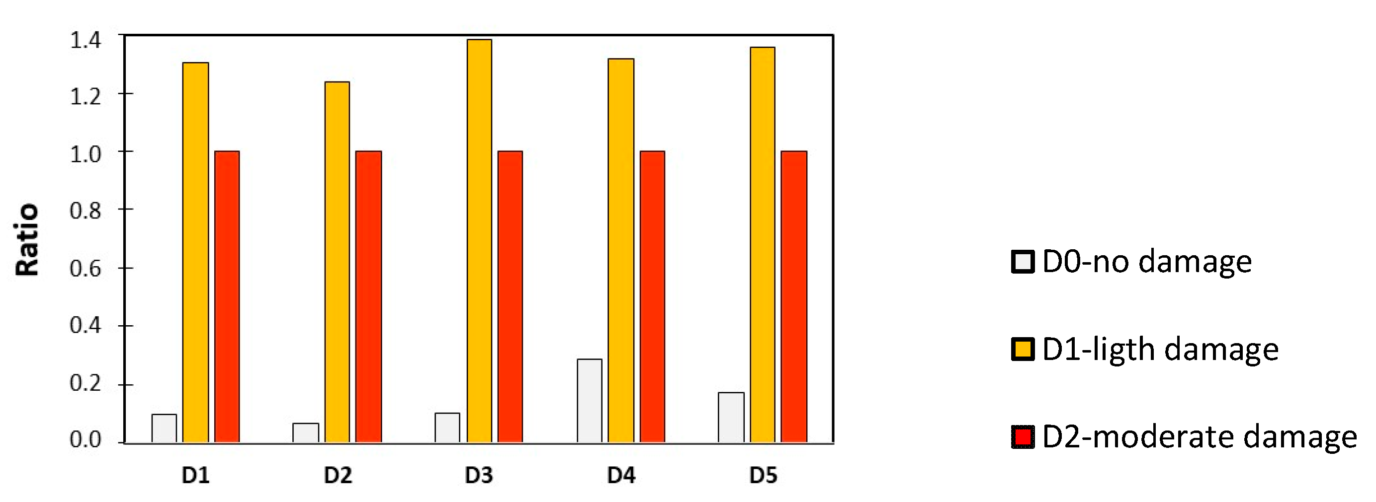
Figure 9. As can be noticed, the difference between the two methods in terms of forecast is about 30% for DL0 and DL1, and it is similar for all districts.
5.2. Detailed Analysis of a Single Urban Area
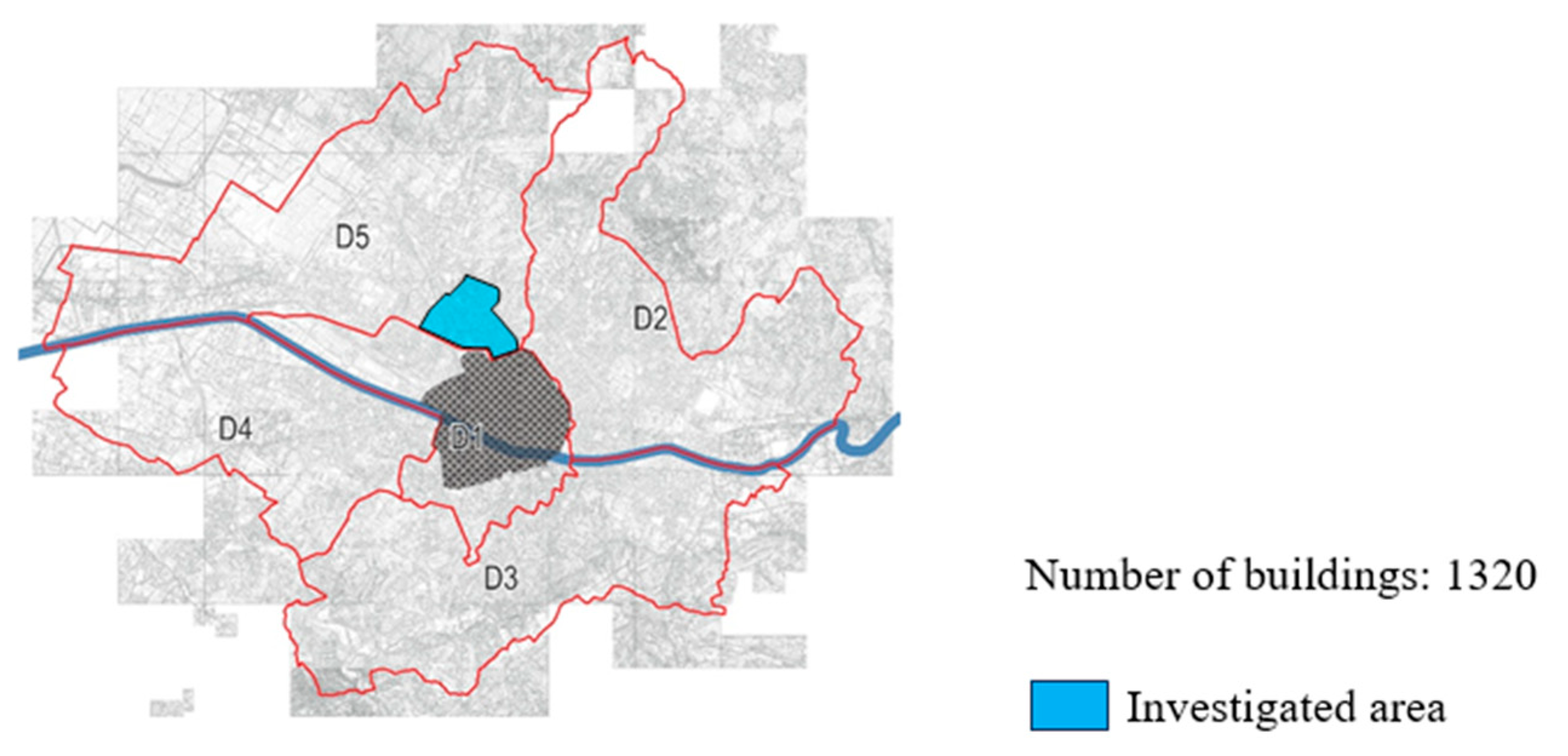
The detailed analysis described in this section has been performed on the area evidenced in
Figure 10, belonging to District 5, which includes 1320 buildings. The classification of the building population has been extremely precise, with a specific check of each building in the sample.
Figure 11 shows the classification made for the assumed parameters. The amplification factor has been assumed as a function of the buildings’ periods (i.e., of their numbers of floors) and of the mechanical properties of the soil (the micro-zones considered in the soil investigation).
In the examined area, there are only two micro-zones (MZ2 and MZ3), as shown in
Figure 12, together with the expression of the amplification factor as a function of the buildings’ periods in such micro-zones.
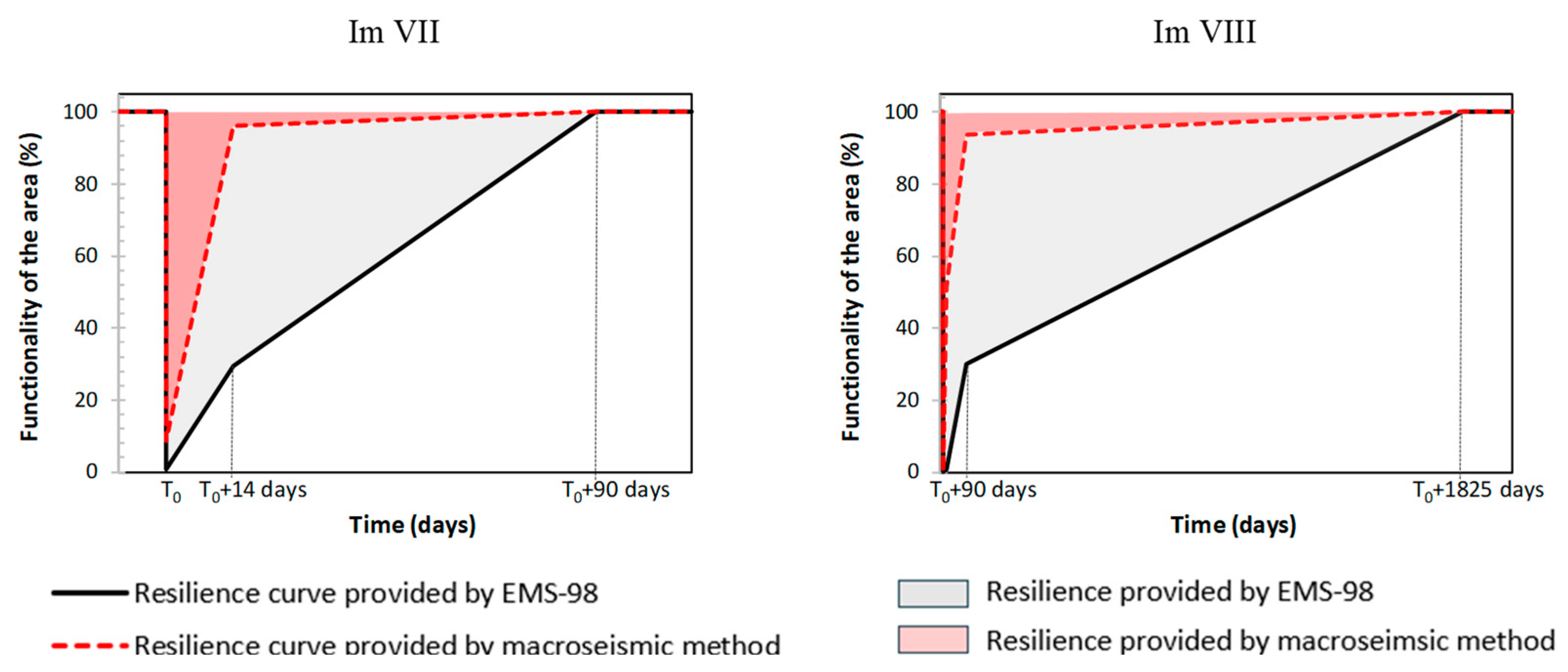
Figure 13 shows the damage levels provided by the two applied methods for two intensity levels: Im VII (PGA = 0.1089 g) and Im VIII (PGA = 0.1796 g), which approximately represent, respectively, the seismic intensities of the “life safety” and “collapse prevention” limit states of the area. As can be noticed, the damage level assigned to the checked sample certainly increases from Im VII to Im VIII, achieving the damage level 3. The two methods provide damage assessments that are significantly different from each other. The prevision of the EMS 98 is much more severe.
For Im VII, the EMS-98 predicts the attainment of DL2 for the majority of the sample, whilst the macro-seismic approach attributes DL1 for almost 90% of the buildings. Likewise, for Im VIII, the EMS-98 predicts the attainment of DL3 for 70% of the buildings, whilst the macro-seismic method assumes DL1 for the majority of the buildings.
Figure 13 even shows the comparison between the two sets of results as the ratio between the ones provided by the EMS-98 and those from the macro-seismic method.
The assessment of the damage level achieved by the buildings can be used to predict the lack of functionality of the area. For this purpose, the percentage of buildings experiencing each damage level has been compared to the recovery time provided by AeDES, reported in
Table 6.
Figure 14 shows the recovery time referred to the building of the examined micro-area, together with the corresponding resilience curves found with the two adopted approaches. The lack of functionality occurs at time T
0, i.e., when the seismic event bursts [
42]. The resilience shown in the figure refers to both the seismic intensities considered (Im VII and Im VIII). The comparison between the curves referring to the two methods evidences the effect of the method choice on the recovery scenarios of the area.
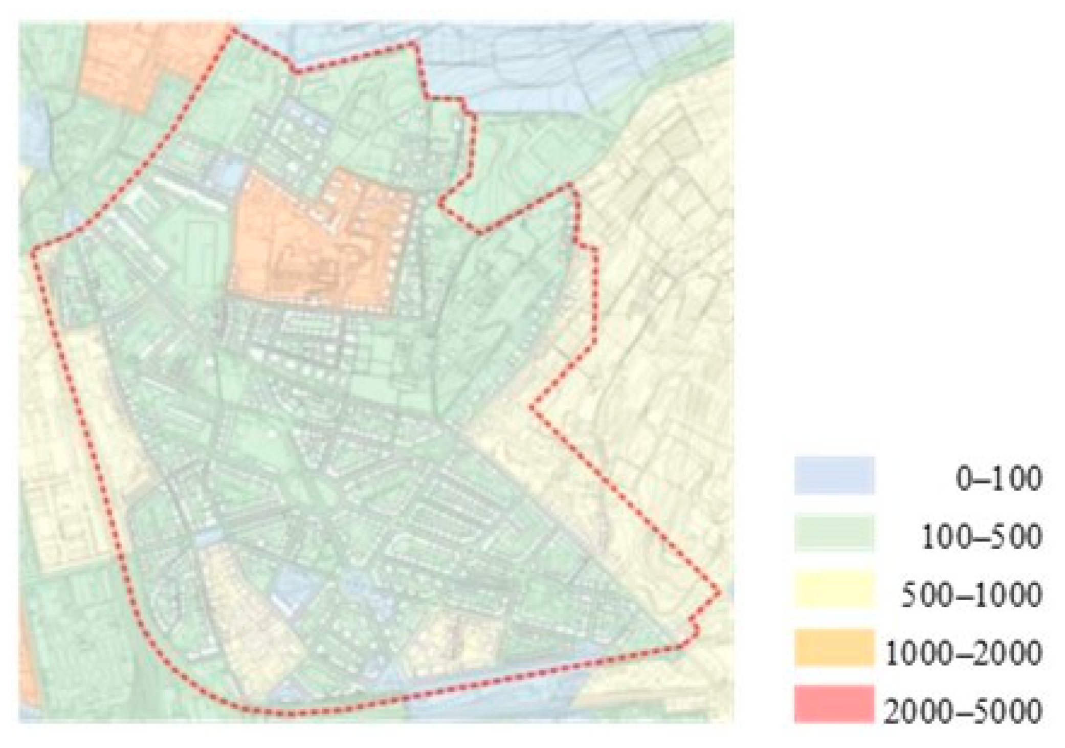
The trend of recovery time leads to assessing the number of inhabitants who should be evacuated as a result of the assumed seismic event. Such a prevision requires knowledge of the number of inhabitants living in the damaged buildings. The number of people to evacuate has been found based on the statistical distribution of the inhabitants, as shown in
Figure 15.
The total number of inhabitants, equal to 20,246, has been determined as the sum of those of each block. The average number of inhabitants for each building, found by dividing the total inhabitants by the total buildings, is equal to 15.49. In
Table 8, the number of evacuated inhabitants has been shown with reference to the two adopted methods and the two considered seismic intensities. As can be noticed, the emergency scenarios provided by the two methods consistently differ from each other.
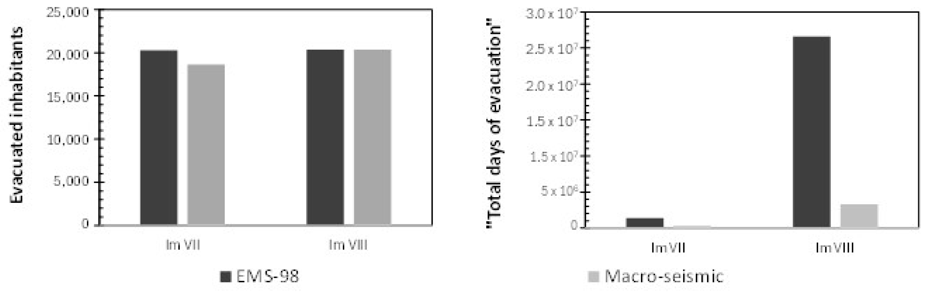
In
Figure 16, the results provided by the two methods in terms of volume of evacuation are shown. Since only a few buildings are assumed to belong to damage level 0, the evacuated people are almost the totality of the inhabitants in both cases.
To account for the gravity of the evacuation during the seismic event, a further indicator has been introduced: the “total days of evacuation”, defined as the product of the evacuated persons and the corresponding days of evacuation. As can be seen in the plots, the EMS-98 method helps to provide a safer assessment of the emergency scenario, with a forecast number of total days of evacuation four times larger than those assessed by the macro-seismic method for Im VII and eight times larger for Im VIII.
6. Conclusive Remarks
This paper shows a vulnerability analysis performed on the residential buildings of Florence. The available databases have been carefully checked by verifying the reliability of the information and integrating the official database, provided by ISTAT. As a result, two datasets have been prepared: a basic one, accounting for the construction year, the structural type, and the number of floors, including all the residential buildings of Florence except the UNESCO perimeter; and a more detailed one, including a larger number of parameters, albeit limited to some urban areas only.
Two different methods have been applied for assessing the seismic vulnerability of the building population: the EMS-98, based on the European macro-seismic scale of intensity; and a further macro-seismic method, derived from the EMS-98 by Giovinazzi and Lagomarsino, which introduces some vulnerability indices related to specific descriptors, such as the conservation state, the building features, the position within the aggregate, and the existence of anti-seismic devices.
The two methods have been applied to two samples: the entire residential building population of Florence, described through the basic dataset; and a smaller area of the town, consisting of 1320 residential buildings and characterized by a high density of population.
The study on the whole building population of Florence has been performed by assuming a seismic intensity representing the “life safety” limit state (PGA = 0.1089 g). The two methods provided similar results. Namely, they forecasted the same amount of buildings for DL2, whilst the EMS-98 assessed a larger (about 30%) achievement of DL1 compared to the macro-seismic method, which allocated many buildings in DL0.
The sample of 1320 buildings, classified according to the most detailed dataset, has been examined by assuming two seismic intensities, representing, respectively, the “life safety” (PGA = 0.1089 g) and “collapse prevention” (PGA = 0.1796 g) limit states. The results provided by the two methods presented consistent differences. Indeed, the EMS-98 method attributes the higher level of attained damage (DL3) to a number of buildings 10 times larger than the macro-seismic method.
The forecasted damage levels have been used to describe the damage scenarios related to the assumed ground motions and to determine the corresponding resilience curves. Finally, the assumed emergency scenarios have been enhanced by considering the average number of inhabitants of each building and assessing the number of evacuated people.
The performed analyses pointed out some vulnerability sources of the residential buildings’ population of Florence. As regards the masonry buildings, which represent the large majority, the main vulnerability consists of the inadequate stiffness of the floors, often made without any perimetral curb, and of the lack of connections between orthogonal walls. Even the roof can represent a vulnerability source, both for the pushing effect on the walls and for the structural under-dimensioning. RC buildings, instead, are designed without any attention to horizontal actions and easily present plan irregularities, soft stories, and short columns. Even the non-structural elements represent a vulnerability source, inducing the overcoming of serviceability thresholds at the occurrence of moderate ground motions.
This paper presents numerous original results on the seismic vulnerability of Florence, found by managing a large and complex sample of buildings, appositely checked and implemented. This work also shows the differences between the two investigated methods and points out the importance of the quality of the buildings’ database for forecasting emergency scenarios.
Author Contributions
Conceptualization, B.P., M.T. and S.V.; methodology, B.P., M.T. and S.V.; software, B.P.; validation, B.P.; formal analysis, B.P., M.T. and S.V.; investigation, B.P.; resources, M.T. and B.P.; data curation, B.P.; writing—original draft preparation, S.V.; writing—review and editing, S.V.; supervision, M.T.; project administration, M.T. All authors have read and agreed to the published version of the manuscript.
Funding
This research received no external funding.
Data Availability Statement
The data obtained through the survey will be provided upon request.
Acknowledgments
We are grateful to the Seismic Office of the Tuscan Region for their support of this research.
Conflicts of Interest
The authors declare no conflicts of interest.
References
- Calvi, G.M.; Pinho, R.; Magenes, G.; Bommer, J.; Restrepo-Vélez, L.F.; Crowley, H. Development of seismic vulnerability assessment methodologies over the past 30 years. ISET J. Earthq. Tech. 2006, 43, 75–104. [Google Scholar]
- Anelli, A.; Mori, F.; Mendicelli, A. Mapping urban limit conditions in the perspective of disaster risk prevention and land management. Ital. J. Geosci. 2022, 141, 167–183. [Google Scholar] [CrossRef]
- Zuccaro, G.; Dolce, M.; De Gregorio, D.; Speranza, E.; Moroni, C. La scheda CARTIS per la caratterizzazione tipologico- strutturale dei comparti urbani costituiti da edifici ordinari. Valutazione dell’esposizione in analisi di rischio sismico. In Proceedings of the GNGTS 2015, Trieste, Italy, 17–19 November 2015. [Google Scholar]
- Mouroux, P.; Le Brun, B. Risk-Ue Project: An Advanced Approach to Earthquake Risk Scenarios with Application to Different European Towns. In Assessing and Managing Earthquake Risk; Geotechnical, Geological and Earthquake Engineering; Oliveira, C.S., Roca, A., Goula, X., Eds.; Springer: Dordrecht, The Netherlands, 2006; pp. 479–508. [Google Scholar]
- Giovinazzi, S.; Marchili, C.; Di Pietro, A.; Giordano, L.; Costanzo, A.; La Porta, L.; Pollino, M.; Rosato, V.; Lückerath, D.; Milde, K.; et al. Assessing Earthquake Impacts and Monitoring Resilience of Historic Areas: Methods for GIS Tools. ISPRS Int. J. Geo-Inf. 2021, 10, 461. [Google Scholar] [CrossRef]
- Arrighi, C.; Tanganelli, M.; Cardinali, V.; Cristofaro, M.T.; De Stefano, M.; Castelli, F. Multi-risk analysis, mitigation and resilience in historical cities. In Proceedings of the EGU General Assembly 2022, Vienna, Austria, 23–27 May 2022; p. EGU22-4118. [Google Scholar] [CrossRef]
- Del Gaudio, C.; De Martino, G.; Di Ludovico, M.; Manfredi, G.; Prota, A.; Ricci, P.; Verderame, G.M. Empirical fragility curves for masonry buildings after the 2009 L’Aquila. Italy, earthquake. Bull. Earthq. Eng. 2019, 17, 6301–6330. [Google Scholar] [CrossRef]
- Cardinali, V.; Cristofaro, M.T.; Ferrini, M.; Nudo, R.; Paoletti, B.; Tanganelli, M. An interdisciplinary approach for the seismic vulnerability assessment of historical centres in masonry building aggregates: Application to the city of Scarperia, Italy. Int. Arch. Photogramm. Remote Sens. Spat. Inf. Sci.-ISPRS Arch. 2020, XLIV-M-1-2020, 667–674. [Google Scholar] [CrossRef]
- Cardinali, V.; Cristofaro, M.T.; Ferrini, M.; Nudo, R.; Paoletti, B.; Tanganelli, M. A Multiscale Approach for the Seismic Vulnerability Assessment of Historical Centres in Masonry Building Aggregates: Cognitive Approach and Interdisciplinary Perspectives. Int. J. Archit. Herit. 2022, 16, 839–864. [Google Scholar] [CrossRef]
- Cardinali, V.; Tanganelli, M.; Bento, R. Seismic assessment of the XX century masonry buildings in Florence: Vulnerability insights based on urban data acquisition and nonlinear static analysis. J. Build. Eng. 2022, 57, 104801. [Google Scholar] [CrossRef]
- Cardinali, V.; Tanganelli, M.; Bento, R. A hybrid approach for the seismic vulnerability assessment of the modern residential masonry buildings. Int. J. Disaster Risk Reduct. 2022, 79, 103193. [Google Scholar] [CrossRef]
- Paoletti, B.; Tanganelli, M. Multiscale analysis of the seismic vulnerability for the specific anti-seismic recovery plans. In Proceedings of the IX Convegno Internazionale REUSO Roma, Capitale d’Italia 150 Anni Dopo Temi Contemporanei, Roma, Italy, 1–3 December 2021. [Google Scholar]
- Faccioli, E.; Pessina, V.; Calvi, G.M.; Borzi, B. A study on damage scenarios for residential buildings in Catania city. J. Seismol. 1999, 3, 327–343. [Google Scholar] [CrossRef]
- Bernardini, A.; Giovinazzi, S.; Lagomarsino, S.; Parodi, S. Matrici di probabilità di danno implicite nella scala EMS-98 per tipologie di edilizia abitativa. In Proceedings of the XII Convegno ANIDIS “L’ingegneria Sismica in Italia”, Pisa, Italy, 10–14 June 2007. [Google Scholar]
- Paoletti, B.; De Stefano, M.; Tanganelli, M. La valutazione del rischio sismico su scala territoriale. In La Microzonazione Sismica e le Analisi delle Condizioni Limite per l’Emergenza del Comune di Firenze; I Libri della Giunta Regionale—Territori; Regione Toscana: Florence, Italy, 2022; pp. 151–164. ISBN 0978-88-7040-137-0. [Google Scholar]
- Dolce, M.; Masi, A.; Marino, M.; Vona, M. Earthquake Damage Scenarios of the Building Stock of Potenza (Southern Italy) Including Site Effects. Bull. Earthq. Eng. 2003, 1, 115–140. [Google Scholar] [CrossRef]
- Whitman, R.V.; Reed, J.W.; Hong, S.T. Earthquake damage probability matrices. In Proceedings of the Fifth World Conference on Earthquake Engineering, Rome, Italy, 25–29 June 1973; pp. 2531–2540. [Google Scholar]
- Meroni, F.; Petrini, V.; Zonno, G. Valutazione della vulnerabilità di edifici su aree estese tramite dati ISTAT. In Proceedings of the 9° Convegno Nazionale—L’Ingegneria Sismica in Italia, Torino, Italy, 20–23 September 1999. CD-ROM (In Italian). [Google Scholar]
- Regolamento 30 Gennaio 2020, n. 5/R. Regolamento di Attuazione dell’Articolo 104 della Legge Regionale 10 Novembre 2014, n. 65 (Norme per il Governo del Territorio) Contenente Disposizioni in Materia di Indagini Geologiche, Idrauliche e Sismiche. Bollettino Ufficiale n. 6, Parte Prima, del 5 Febbraio 2020 (In Italian). Available online: https://raccoltanormativa.consiglio.regione.toscana.it/articolo?urndoc=urn:nir:regione.toscana:regolamento.giunta:2020-01-30;5/R (accessed on 25 October 2024).
- Corsanego, A. A review of methodologies for seismic vulnerability assessment. In Proceedings of the International Conference on Reconstruction. Restoration and Urban Planning of Towns and Regions in Seismic Prone Areas, Skopje, North Macedonia, 5–9 November 1985. [Google Scholar]
- Leggieri, V.; Mastrodonato, G.; Uva, G. GIS Multisource Data for the Seismic Vulnerability Assessment of Buildings at the Urban Scale. Buildings 2022, 12, 523. [Google Scholar] [CrossRef]
- Giovinazzi, S.; Lagomarsino, S. A macroseismic model for the vulnerability assessment of buildings. In Proceedings of the 13th World Conference on Earthquake Engineering, Vancouver, BC, Canada, 1–6 August 2004. [Google Scholar]
- DPC. Manuale per la Compilazione della Scheda di Primo Livello di Rilevamento di Danno. Pronto Intervento e Agibilità per Edifici Ordinari nell’Emergenza Post-Sismica (AeDES); Dipartimento della Protezione Civile, Ed.; Presidenza del Consiglio dei Ministri: Roma, Italy, 2014. (In Italian) [Google Scholar]
- Gruppo Nazionale per la Difesa dai Terremoti—GNDT-SSN. Scheda di Esposizione e Vulnerabilità e di Rilevamento Danni di Primo e Secondo Livello (Muratura e c. a.); Gruppo Nazionale per la Difesa dai Terremoti: Rome, Italy, 1994. (In Italian) [Google Scholar]
- Grünthal, G.; European Seismological Commission (Eds.) European Macroseismic Scale 1998: EMS-98, 2nd ed.; Cahiers du Centre Européen de Géodynamique et de Séismologie; European Seismological Commission, Subcommission on Engineering Seismology, Working Group Macroseismic Scales: Luxembourg, 1998; Volume 15. [Google Scholar]
- Lagomarsino, S.; Giovinazzi, S. Macroseismic and mechanical models for the vulnerability and damage assessment of current buildings. Bull. Earthq. Eng. 2006, 4, 415–443. [Google Scholar] [CrossRef]
- Braga, F.; Dolce, M.; Liberatore, D. A statistical study on damaged buildings and an ensuing review of the M.S.K.—76 scale. In Proceedings of the 7th European Conference on Earthquake Engineering, Athens, Greece, 20–25 September 1982. [Google Scholar]
- Ruggieri, S.; Perrone, D.; Leone, M.; Uva, G.; Aiello, M.A. A prioritization RVS methodology for the seismic risk assessment of RC school buildings. Int. J. Disaster Risk Reduct. 2020, 51, 101807. [Google Scholar] [CrossRef]
- Orefice, G. Storia dell’Urbanistica (Serie Regionale) Firenze e l’Unità d’Italia: Un Nuovo Paesaggio Urbano—Storia dell’Urbanistica/Toscana XIII; Edizioni Kappa: Bologna, Italy, 2011. (In Italian) [Google Scholar]
- Brilli, A. Il Viaggio della Capitale. Torino, Firenze e Roma Dopo l’Unità d’Italia; UTET: Turin, Italy, 2017. [Google Scholar]
- ISTAT. Censimento della Popolazione e delle Abitazioni. Public Dataset. 2011. Available online: https://www.istat.it/it/censimenti-permanenti/censimenti-precedenti/popolazione-e-abitazioni/popolazione-2011 (accessed on 25 October 2024).
- Coli, M.; Rubellini, P. Geological anamnesis of the Florence area, Italy. Z. Dtsch. Ges. Geowiss. (Ger. J. Geosci.) 2013, 164, 581–589. [Google Scholar] [CrossRef] [PubMed]
- Coli, M.; Guerri, L.; Rubellini, P. Geotechnical characterization of the Florence (Italy) soils. In Proceedings of the 5th Asian Regional Conference on Soil Mechanics and Geotechnical Engineering, Fukuoka, Japan, 9–13 November 2015. [Google Scholar]
- Rovida, A.; Locati, M.; Camassi, R.; Lolli, B.; Gasperini, P.; Antonucci, A. Catalogo Parametrico dei Terremoti Italiani (CPTI15), Version 4.0′; Istituto Nazionale di Geofisica e Vulcanologia (INGV): Palermo, Italy, 2022. [Google Scholar]
- Ministero delle Infrastrutture e dei Trasporti. Aggiornamento delle Norme Tecniche per le Costruzioni. D.M. del 17/01/2018. G.U. n.42 del 20/2/2018; Ministero delle Infrastrutture e dei Trasporti: Roma, Italy, 2018. (In Italian)
- Margottini, C.; Molin, D.; Serva, L. Intensity versus ground motion: A new approach using Italian data. Eng. Geol. 1992, 33, 45–58. [Google Scholar] [CrossRef]
- Paoletti, B. Gestione dell’Emergenza in un Centro Urbano Complesso: La Città di Firenze. Ph.D. Thesis, Università di Firenze, Florence, Italy, 2022. [Google Scholar]
- Vannucci, G.; Gasperini, P.; Boccaletti, M. Database e Carta della Zonazione Sismica dell’Area Urbana di Firenze: Valutazione del Rischio per i Beni Artistici e Culturali’, CNR,-Progetto Finalizzato “Beni Culturali”, Sottoprogetto 1, Tema 1.2, Linea 1.2.3. 2004. Available online: https://opendata.comune.fi.it/page_dataset_show?id=d236615e-4ba7-4b82-9219-248342990f16 (accessed on 25 October 2024).
- Rosti, A.; Rota, M.; Penna, A. Empirical fragility curves for Italian URM buildings. Bull. Earthq. Eng. 2021, 19, 3057–3076. [Google Scholar] [CrossRef]
- Cardinali, V. Seismic Vulnerability Assessment of the Residential URM Buildings Built During the XX Century in Florence. Ph.D. Thesis, UNIFI, Florence, Italy, 2021. Available online: https://flore.unifi.it/handle/2158/1238437?mode=simple (accessed on 25 October 2024).
- Vona, M. Fragility Curves of Existing RC Buildings Based on Specific Structural Performance Levels. Open J. Civil. Eng. 2014, 4, 120–134. [Google Scholar] [CrossRef]
- Cimellaro, G.P.; Renschler, C.; Reinhorn, A.M.; Arendt, L. PEOPLES: A framework for evaluating resilience. J. Struct. Eng. 2016, 142, 04016063. [Google Scholar] [CrossRef]
Figure 1.
Maps of Florence. On the left: map of 1873;on the right: map of 1937 (provided by Istituto Geografico Militare).
Figure 1.
Maps of Florence. On the left: map of 1873;on the right: map of 1937 (provided by Istituto Geografico Militare).
Figure 2.
Map of the town of Florence.
Figure 2.
Map of the town of Florence.
Figure 5.
Maps of amplification factor related to the III level micro-zones.
Figure 5.
Maps of amplification factor related to the III level micro-zones.
Figure 6.
Comparison between damages occurred after the 1895 earthquake and the III level SM. (
a) EMS-98 classification [
38]; (
b) III level micro-zones (periods between 0.1 s and 0.5 s); (
c) superposition of the two maps.
Figure 6.
Comparison between damages occurred after the 1895 earthquake and the III level SM. (
a) EMS-98 classification [
38]; (
b) III level micro-zones (periods between 0.1 s and 0.5 s); (
c) superposition of the two maps.
Figure 7.
Analysis of the parameters considered in the first dataset.
Figure 7.
Analysis of the parameters considered in the first dataset.
Figure 8.
Damage scenarios provided by the two performed methods (Im VII).
Figure 8.
Damage scenarios provided by the two performed methods (Im VII).
Figure 9.
Ratio between the results provided by the two methods.
Figure 9.
Ratio between the results provided by the two methods.
Figure 10.
Urban area selected for the detailed analysis.
Figure 10.
Urban area selected for the detailed analysis.
Figure 11.
Description of the dataset of the area.
Figure 11.
Description of the dataset of the area.
Figure 12.
Relationship between period, micro-zones, and amplification factor.
Figure 12.
Relationship between period, micro-zones, and amplification factor.
Figure 13.
Damage levels provided by the two methods of analysis and their comparison.
Figure 13.
Damage levels provided by the two methods of analysis and their comparison.
Figure 14.
Resilience of the area according to the two methods of analysis.
Figure 14.
Resilience of the area according to the two methods of analysis.
Figure 15.
Population density (inhabitants per km
2) of the area [
34].
Figure 15.
Population density (inhabitants per km
2) of the area [
34].
Figure 16.
Response parameters of the assessed evacuation at the occurrence of the earthquake.
Figure 16.
Response parameters of the assessed evacuation at the occurrence of the earthquake.
Table 1.
Seismic intensity of Florence.
Table 1.
Seismic intensity of Florence.
| Return Period | 30 Years | 50 Years | 475 Years | 975 Years |
|---|
| Limit state | Operational | Deformation | Life Safety | Collapse Prevention |
| PGA | 0.047 g | 0.056 g | 0.131 g | 0.167 g |
| Im | 5.324 | 5.673 | 7.369 | 7.854 |
Table 2.
Amplification factors in the micro-zones (MZs).
Table 2.
Amplification factors in the micro-zones (MZs).
| Period | Side Instability | Local Amplification |
|---|
| MZ_2 | MZ_3 | MZ_4 | MZ_5 | MZ_6 | MZ_2 | MZ_3 | MZ_4 | MZ_5 | MZ_6 |
|---|
| 0.1 s–0.5 s | 1.1–1.2 | 1.5–1.6 | 1.7–1.8 | - | - | 1.1–1.2 | 1.5–1.6 | 1.7–1.8 | 1.9–2.0 | 2.3–2.4 |
| 0.4 s–0.8 s | 1.1–1.2 | 1.3–1.4 | - | - | - | 1.3–1.4 | 1.5–1.6 | - | - | - |
| 0.7 s–0.11 s | 1.1–1.2 | 1.3–1.4 | - | - | - | 1.1–1.2 | 1.3–1.4 | - | - | - |
Table 3.
Descriptive parameters assumed for the two datasets.
Table 3.
Descriptive parameters assumed for the two datasets.
| Parameters of the 1st (ISTAT) Dataset | Parameters of the Detailed (Integrated) Dataset |
|---|
| Date of construction | Date of construction |
| Structural system | Structural system |
| Number of floors | Number of floors |
| | State of preservation |
| | Plan irregularity |
| | Position (in aggregate/isolated) |
| | Position within the aggregate |
| | Aseismic devices |
Table 4.
Description of the considered macro-clusters.
Table 4.
Description of the considered macro-clusters.
| Construction Period | Structure | Macro-Cluster |
|---|
| before 1895 | M | C1-M |
| 1895–1937 | M | C2-M |
| RC | C2-RC |
| 1937–1955 | M | C3-M |
| RC | C3-RC |
| 1955–1978 | M | C4-M |
| RC | C4-RC |
| 1978–1991 | RC | C5-RC |
| 1991–2000 | RC | C6-RC |
| 2000–2016 | RC | C7-RC |
Table 5.
Structural type and vulnerability class of the 10 macro-clusters.
Table 5.
Structural type and vulnerability class of the 10 macro-clusters.
| Macro-Cluster | C1-M | C2-M | C2-RC | C3-M | C3-RC | C4-M | C4-RC | C5-RC | C6-RC | C7-RC |
|---|
| Structural type | TS1 | TS3 | TS8 | TS6 | TS8 | TS6 | TS8 | TS9 | TS9 | TS10 |
| VC | B | B | C | C | C | C | C | D | E | E |
Table 6.
Damage levels stated by EMS-98 and EaDES.
Table 6.
Damage levels stated by EMS-98 and EaDES.
| EMS-98 | AeDES |
|---|
| DL | Description | DL | Damage Extension | Description | Recovery Time |
|---|
| D0 | No damage | DL0 | - | No damage | - |
| DL1 | From negligible to light damage
no structural damage
light non-structural damage | DL1 | <1/3
1/3–2/3
>2/3 | Light damage | 14 days |
| DL2 | Moderate damage
light structural damage
moderate non-structural damage | DL2–DL3 | <1/3 | Medium damage | 90 days |
| DL3 | Relevant/extensive damage
light structural damage
extensive non-structural damage | DL2–DL3 | >1/3 | Medium/extensive damage | 1825 days |
| DL4 | Very extensive damage
extensive structural damage
very extensive non-structural damage | DL4–DL5 | 1/3–2/3
>2/3 | Very extensive damage | 3650 days |
| DL5 | Very dangerous structural damage | DL4–DL5 | >2/3 | Very dangerous structural damage | 3650 days |
Table 7.
“Modifier” considered in the macro-seismic method.
Table 7.
“Modifier” considered in the macro-seismic method.
| Macro-Cluster | Type | Assumed “Modifier” in the Macro-Seismic Method | Vulnerability |
|---|
| Conservation State | Number of Floors | Plan Irregularity | Anti-Seismic Devices | Aggregate | High Irregularity | Vmin | V | Vmax |
|---|
| C1-M | M1 | X | X | X | X | X | X | 0.62 | 0.873 | 1.02 |
| C2-M | M5 | X | X | X | X | X | X | 0.46 | 0.74 | 1.02 |
| C2-C | RC1 | X | X | X | | X | | 0.30 | 0.644 | 1.02 |
| C3-M | M6 | X | X | X | X | X | X | 0.30 | 0.616 | 0.86 |
| C3-C | RC1 | X | X | X | | X | | 0.30 | 0.644 | 1.02 |
| C4-M | M6 | X | X | X | X | X | X | 0.30 | 0.616 | 0.86 |
| C4-C | RC1 | X | X | X | | X | | 0.30 | 0.644 | 1.02 |
| C5-RC | RC2 | X | X | X | | X | | 0.14 | 0.484 | 0.86 |
| C6-RC | RC2 | X | X | X | | X | | 0.14 | 0.484 | 0.86 |
| C7-RC | RC3 | X | X | X | | X | | −0.02 | 0.324 | 0.70 |
Table 8.
Obtained assessment of the evacuation: duration and involved inhabitants.
Table 8.
Obtained assessment of the evacuation: duration and involved inhabitants.
| | | EMS-98 | Macro-seismic Method |
|---|
| | | DL0 | DL1 | DL2 | DL3 | DL0 | DL1 | DL2 | DL3 |
|---|
| Im VII | No. of buildings | 10 | 387 | 923 | - | 116 | 1153 | 51 | - |
| Recovery time (days) | - | 14 | 90 | 1825 | 0 | 14 | 90 | 1825 |
| No. of evacuated inhabitants | - | 5995 | 14,297 | - | 1797 | 17,860 | 790 | - |
| Im VIII | No. of buildings | 4 | 6 | 387 | 923 | 4 | 674 | 558 | 84 |
| Recovery time (days) | - | 14 | 90 | 1825 | 0 | 14 | 90 | 1825 |
| No. of evacuated inhabitants | - | 93 | 5995 | 14,297 | 62 | 10,440 | 8643 | 1301 |
| Disclaimer/Publisher’s Note: The statements, opinions and data contained in all publications are solely those of the individual author(s) and contributor(s) and not of MDPI and/or the editor(s). MDPI and/or the editor(s) disclaim responsibility for any injury to people or property resulting from any ideas, methods, instructions or products referred to in the content. |
© 2024 by the authors. Licensee MDPI, Basel, Switzerland. This article is an open access article distributed under the terms and conditions of the Creative Commons Attribution (CC BY) license (https://creativecommons.org/licenses/by/4.0/).


