Article

Comparative Analysis of Indoor Localization across Various Wireless Technologies

Department of Applied Computer Science, The University of Winnipeg, Winnipeg, MB R3B 2E9, Canada
*
Author to whom correspondence should be addressed.
Eng 2023, 4(3), 2293-2308; https://doi.org/10.3390/eng4030131
Submission received: 4 August 2023 / Revised: 29 August 2023 / Accepted: 5 September 2023 / Published: 8 September 2023
(This article belongs to the Section Electrical and Electronic Engineering)

Abstract

:
This article examines the comparative effectiveness of three indoor node localization techniques—Multilateration, the Weighted Centroid algorithm, and Grid-based Received Signal Strength (RSS)—in wireless networking applications. The comparison is based on their performance against localization accuracy using RSS Indicator (RSSI) data in three experiments. The experiments utilized internally generated or real-world datasets with RSSI values for the unknown tag nodes. The datasets were obtained from various sources and evaluated in different scenarios to determine the efficiency of the three localization techniques. The results were evaluated and compared using mean error and standard deviation metrics. The findings indicate that trilateration achieves superior localization accuracy and precision in a Bluetooth Low Energy (BLE) environment compared to Wi-Fi and ZigBee. The Centroid technique showed the highest resistance to noise and outliers but is positioned biased (unlike Trilateration). Besides that, the Grid-based RSS technique is highly sensitive to noise, and theoretical RSS. These findings can greatly assist researchers and network operators in carefully selecting the most suitable localization technique for their wireless networking applications, taking into account the specific wireless technology utilized and their unique needs and limitations.

1. Introduction

Indoor localization has become a paramount component across many fields, such as healthcare, security, and retail [1,2]. These diverse applications require accurate and reliable indoor localization systems to optimize functionality and performance. Outdoor localization systems rely on GPS and Point of Interest (POI) data. POI data [3] is used in many geospatial applications, providing semantic information for places of interest and has many geospatial applications. On the other hand, indoor systems demand specialized techniques that consider the unique characteristics of indoor environments, such as complex building structures, multiple floors, and potential signal interference. In response to these challenges, various approaches were developed to achieve precise geolocation within an indoor setting. These methods include multilateration, weighted centroid, and Grid-based RSS [4].
Multilateration utilizes geometric principles to determine the position of devices via the intersection of multiple spheres. This method requires the measurement of the time difference of arrival (TDOA) or distance from devices to at least three known reference points or anchor nodes. These anchor nodes provide the fundamental basis for computational algorithms that triangulate an accurate position. Multilateration improves upon this process by including additional reference points, enhancing the system’s precision [5].
The weighted centroid approach is another technique employed in indoor localization systems. This method leverages the physics center of mass concept to determine device location. By using known anchor nodes with respective distances or received signal strengths as weights, it is possible to calculate a centroid that estimates the target device’s location. This technique can be particularly advantageous when dealing with limited access to anchor nodes or when measurements must be taken quickly [6].
Grid-based RSS is a different approach in indoor localization systems that seeks to maximize accuracy by comparing RSS from multiple devices or nodes in a network, enhancing the resilience of a wireless network [7]. This method uses RSSI data to estimate the distance between devices and nodes within a network, considering potential variables that can impact signal transmissions, such as physical obstructions and environmental factors [8].
In this paper, we examine and compare the effectiveness of these three distinct indoor localization techniques, utilizing RSSI data procured via internal computations or gathered from a unique real-world dataset. This dataset focuses on indoor localization and comprises RSSI measurements from several nodes positioned within an enclosed space. This study’s driving force stems from the increasing demand for precise and dependable indoor localization methods for various applications. Key goals include assessing these techniques’ accuracy, precision, and resilience and determining their aptitude for various indoor localization scenarios.
Our methodology involves executing experiments, gathering data, scrutinizing results, and evaluating simulation outcomes. The significance of our study is rooted in its capability to augment indoor localization by shedding light on the performance of diverse techniques and pinpointing factors that influence accuracy and precision.
The paper has the following organization. Section 2 provides a literature review on indoor localization and its various approaches. Section 3 presents the problem statement and an overview of indoor localization techniques. The specifics of each experiment and scenario are explored in Section 4, while Section 5 presents the experimental results and analyses with a discussion of their importance. Lastly, Section 6 presents a more insightful discussion of the results from the three experiments, while Section 7 provides the concluding remarks for the paper.

2. Related Work

Various articles provide comparisons between indoor positioning techniques. Liu et al. [9] investigated indoor location algorithms such as angulation, scene analysis, and proximity. Their research also delves into performance metrics, including accuracy, precision, complexity, robustness, scalability, and cost. Technological solutions like GPS, RFID, WLAN, Bluetooth, UWB, and cellular are considered.
In their extensive analysis of wireless indoor localization techniques, the authors in [10] examined various methodologies from a device-oriented standpoint. The authors drew comparisons between device-dependent and device-independent systems, considering factors such as accuracy, cost, scalability, and energy efficiency.
He and Chan [11] examined Wi-Fi fingerprinting technology, focusing on two key aspects: sophisticated positioning methods and effective implementation strategies. The study analyzed different techniques using spatial and temporal signal patterns, considering factors like indoor location accessibility, additional data for position estimation, constraints, and reported average precision.
Hassan et al. [12] studied indoor positioning utilizing visible LED light technology. They analyzed various systems, including Wi-Fi, Bluetooth Low Energy, and GSM, focusing on accuracy, robustness, complexity, cost, and infrastructure reusability. Latif et al. [13] assessed the efficacy of multiple localization methods as well.
Gu et al. [14] also compared indoor localization methods, focusing on wireless personal networks. Their extensive study examined a wide range of options, including both commercial and research-oriented solutions, based on security and privacy, cost, performance, resilience, complexity, user preferences, commercial availability, and limitations. Their findings were consistent with those of prior research [15], emphasizing that each solution employs a certain sort of technology, has its own design, and performs best in specific situations.
A comprehensive overview of current smartphone-based indoor localization techniques was provided by Tiglao et al. [16]. A classification scheme is presented to categorize the techniques, and it was concluded that each method has its own strengths and weaknesses. It was noted that fingerprinting techniques excel when the training phase is executed well, while path loss prediction techniques offer high accuracy in specific environments. Depending on user requirements, a suitable approach is chosen. The authors envision a seamless indoor localization system with cm-level resolution, low-power consumption, and minimal latency.
A low-cost and real-time indoor positioning approach that combines iBeacons and Pedestrian Dead Reckoning (PDR) was proposed by Liu et al. [17]. The Bluetooth Low Energy (BLE)-based iBeacon technology achieved a positioning accuracy with a Root Mean Square Error (RMSE) of 2.75 m through the fusion of Trilateration and fingerprinting methods. The paper introduces a PDR method that incorporates filtering on heading orientation and presents a fusion approach of iBeacon and PDR to address positional jumps and drifting errors. Improved trajectory accuracy and reduced influence of initial position errors and orientation noises were demonstrated in real-time tracking experiments.
Conte et al. [18] demonstrated the utilization of BLE for addressing occupancy detection by introducing a modified iBeacon protocol tailored to the issue. Their system, BLUESENTINEL, presents a straightforward and scalable solution for occupancy detection, leveraging users’ existing smartphones and strategically positioned beacons. Their experiments showed that even with just one beacon per room, accurate results can be achieved, which contrasts with other methods that require a higher number of antennas. The inherent power efficiency of the BLE protocol further supports the feasibility of their approach. Despite its simplicity, BLUESENTINEL achieves accuracy comparable to other advanced methods.
A non-intrusive BLE-based method was proposed for zone-level occupant localization without the need for a dedicated mobile application [19]. This approach involves utilizing a network of BLE beacons to collect RSSI values from nearby devices. These values are then processed into RSSI tuples and utilized by supervised and semi-supervised machine learning models to determine the positions of occupants at the zone level. The supervised ensemble model showed higher accuracy and f1-score, while the semi-supervised clustering model achieved reasonable performance with minimal training data and time. Through a case study conducted in office spaces, the feasibility of this approach was demonstrated, leading to the identification of occupancy profiles that provide valuable insights into occupant behaviors. Implementation of this proposed method offers facility managers valuable occupancy insights for effective building management.
Andò et al. [20] presented an overview of indoor localization systems, focusing on solutions tailored to the Ambient Assisted Living framework. The paper introduces the RESIMA system as a case study, which combines wireless Ultrasound sensors for user positioning and an environmental map to enable User–environment interaction functionalities. The system aims to support end-users in navigating indoor environments safely and efficiently. By utilizing the Multi-Trilateration Algorithm (MTA), the RESIMA system demonstrated its suitability for the addressed application field.
The study [21] extensively assessed deployment problems in wireless sensor networks (WSNs). In smart cities, where sensor nodes are distributed and must remain active to gather and transmit data, achieving optimal node deployment was crucial. Existing work in the field was reviewed, and coverage schemes were categorized into different techniques. The paper highlights the research efforts to minimize power consumption by reducing the number of deployed nodes. A comprehensive comparison of these techniques is provided, considering their respective advantages and drawbacks.
A comprehensive overview of indoor localization techniques and wireless technologies is presented by Obeidat et al. [22]. Various localization system technologies, including satellite-based navigation, inertial navigation systems, magnetic-based navigation, sound-based technologies, optical-based technologies, and RF-based technologies, are covered in the survey. Different localization detection techniques, such as proximity-based techniques, scene analysis, triangulation, and dead reckoning, are also explored. Additionally, the most commonly used localization algorithms and methods are introduced, such as angle of arrival (AOA), time of arrival (TOA), and received signal strength (RSS). Localization method selection depends on several factors, including cost, available resources, the type of environment, and the desired accuracy level. Ultimately, the most powerful technique is determined by its ability to provide high accuracy with minimal computational requirements. Sadowski et al. [23] conducted an extensive investigation comparing the efficacy of Trilateration, K-Nearest Neighbor (KNN), and Naive Bayes techniques. Their study encompassed the utilization of three prevalent IoT wireless technologies: Zigbee, Bluetooth Low Energy (BLE), and Wi-Fi. Experiments were based on three real-world datasets corresponding to three rooms with different levels of interference. The findings revealed that KNN with a parameter value of k = 4 emerged as the most accurate and precise localization method, with Naive Bayes following closely.
The following table (Table 1) summarizes some of these related works.
In contrast to prior studies, our paper utilizes simulations and analytical processes to investigate various indoor positioning methods employing wireless signal technology. The techniques examined include the Centroid algorithm, Trilateration, and Grid-Based RSS method. These methods were evaluated based on efficiency, precision, noise resistance, computational effectiveness, memory consumption, and adaptability across diverse technology environments. Simulations factored in noise levels, technology types (Wi-Fi, ZigBee, BLE), and tag node positioning. The research conclusions offer a comprehensive understanding of each method’s advantages and disadvantages while emphasizing the significance of addressing specific application criteria such as noise intensity, tag node placement, technology type, and dataset volume. All calculations were executed on the cloud-based GPU platform Google Colab to optimize calibration procedures and augment precision. Our results contribute valuable insights into the performance and boundaries of these three methods under diverse circumstances, assisting in choosing appropriate indoor localization techniques.
The key contributions of this paper can be outlined as follows:
  • Investigation of indoor localization techniques, such as the Centroid algorithm, Trilateration, and Grid-Based RSS method. Analyzing their performance behavior under various wireless technologies, as well as varying levels of path loss and setting dimension.
  • Rigorous and comprehensive simulations were conducted under various experimental scenarios. Each method’s performance was thoroughly evaluated based on criteria such as efficiency, precision, and adaptability across diverse technology environments.
  • Detailed analysis of influence factors like noise levels, technology types (Wi-Fi, ZigBee, BLE), and tag node density and layout on the performance of each localization technique.
  • Execution using Google Colab’s cloud-based GPU platform for optimized calibration procedures while providing insights into the selection of appropriate indoor localization techniques.

3. Problem Statement and Localization Techniques

3.1. Problem Statement

Indoor localization has evolved into a significant research field, driven by the rising demand for location-based services within indoor settings. Unlike outdoor localization, indoor localization faces unique challenges such as signal attenuation, multipath fading, and shadowing caused by walls, ceilings, and other obstacles. These factors contribute to the challenge of precisely determining a target’s location in an indoor environment. The need for accurate location-based services in GPS-denied environments, such as underground parking lots, airports, hospitals, and shopping malls, drives the motivation for indoor localization. Traditional GPS-based techniques fail in these environments due to weak or no GPS signals. Indoor localization can solve this problem by using wireless signals from Wi-Fi, Bluetooth, or ZigBee devices to estimate the location of a target. Therefore, the aim of this study is to explore and compare different indoor localization techniques and evaluate their performance under different scenarios. The findings of this study can be useful for developing efficient and accurate indoor localization systems for various applications.

3.2. Localization Techniques

3.2.1. Trilateration

Trilateration [24] is a model-based technique that uses distances to determine the receiver’s location numerically. To calculate with Trilateration, we need three transmitting devices to obtain a 2D position and four to find a 3D position. The distances between the transmitter and the receivers and the right number of transmitting devices are necessary. A frequent method for calculating the distance between devices uses a signal’s RSSI. For 2D space, with three anchor nodes i ,   i 1 , 2 , 3 , located at the position a i , b i , we can find the unknown position ( x , y ) of the receiver as
a 1 x 2 + b 1 y 2 = d 1 2 a 2 x 2 + b 2 y 2 = d 2 2 a 3 x 2 + b 3 y 2 = d 3 2
where d i denotes the distance between the unknown sensor and the anchor i . To minimize the location error, we need to minimize the following objective function using a non-linear least squares technique:
f x , y = i = 1 3 x a i 2 + y b i 2 d i 2

3.2.2. The Weighted Centroid Algorithm

The basic idea of a weighted centroid localization algorithm [25] based on RSSI is that unknown nodes gather RSSI information from the beacon nodes around them. Assuming there are anchor nodes in the WSN, with coordinates a i , b i where i 1 , 2 , 3 , , n , the location of the unknown node can be obtained by using the improved centroid algorithm estimating the coordinates of n nodes as
x = 1 i = 1 n w i i = 1 n w i × a i y = 1 i = 1 n w i i = 1 n w i × b i
where w i denotes the weight of anchor i , given by the following formula:
w i = R S S I i R S S I 1 + R S S I 2 + R S S I 3 + + R S S I n
where R S S I i denotes the measured RSSI between anchor i and the unknown tag node, and i 1 , 2 , 3 , , n , with n as the number of anchors.

3.2.3. Grid-Based RSS

In this algorithm [8], a floorplan is considered and divided into grid points of possible mobile locations. During the offline phase, theoretical received RSS values are calculated according to each grid point’s representative (measured) RSS model. During the online phase, the measured RSS values are ‘compared’ with the theoretical ones for each grid point. The grid point, which has its theoretical RSS values closest (least squares) to the ones measured, is determined as the estimated location x , y
x , y = m i n x , y i = 1 n R S S x , y , i , T R S S i , M 2
where R S S x , y , i , T denotes the theoretical RSS value at the position x , y from anchor i , i 1 , 2 , 3 , , n . R S S i , M is the measured RSS value from anchor i .

4. Methodology

This section presents three scenarios based on those we have performed in our experiments. The results of the experiments are presented in the experiment and results section.

4.1. Experiment 1 (Tag Nodes Deployed Randomly)

This first experiment aims to explain how the three localization techniques localize the unknown nodes. In this experiment, we have 7–200 tag nodes distributed in a 2D x , y - coordinate plane and a total of four anchor nodes, which are placed on all four corners. Figure 1 shows the distribution of 7 tag nodes and anchor nodes.
These four anchor nodes measure the RSSI values for each tag node. For each tag node, we have four RSSI values from four anchors. Then, using these RSSI values, we estimate the location of tag nodes by leveraging localization techniques, as presented in Section 3.2.

4.2. Experiment 2 (Tag Nodes across Boundaries/Center)

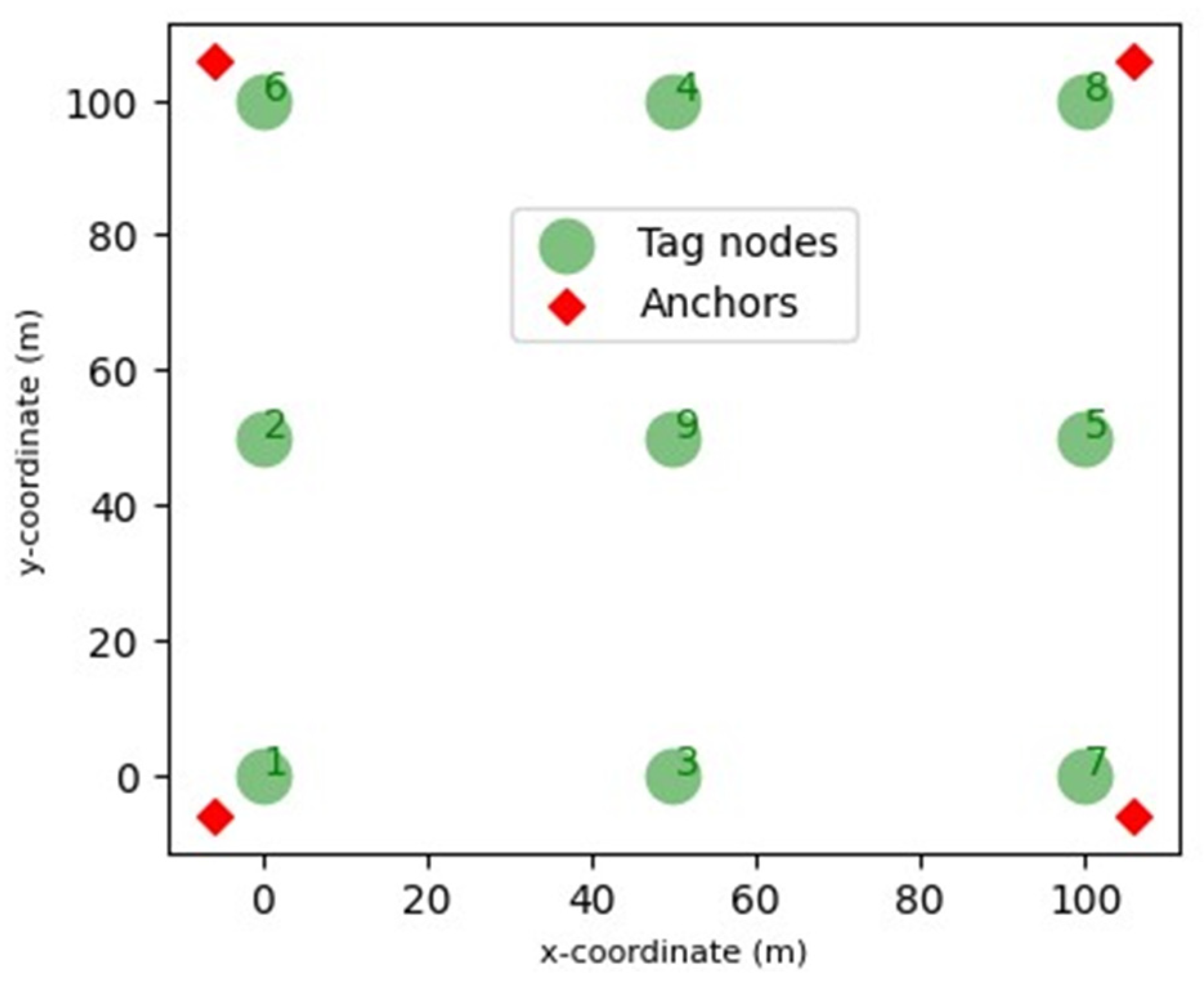
This experiment is based on simulated data we have generated in Python. In this, we are placing the tag nodes starting from the center to the boundaries of the simulation workspace (x-y coordinate plane). Each tag node has its own identifying number. Here, we also use the four anchor nodes, one for each corner. Figure 2 represents the x-y coordinate simulation workspace with tag nodes (green).
The four anchors communicate with every tag node in the workspace and measure the RSSI values corresponding to tag nodes. So, for each tag node, we have four measured RSSI values, which we are using to locate a tag node. The experiment and result section shows the localization results from three different techniques (Multilateration, Grid-based RSS, and Centroid Algorithm).

4.3. Experiment 3 (Real-World Dataset)

In this experiment, we perform the localization based on a real-world dataset [23,26]. Unlike experiments 2 and 1, in which we have internally generated a dataset (RSSI values), this experiment uses existing RSSI values recorded from real-world settings using three different wireless technologies: Wi-Fi, Bluetooth, and ZigBee. The brief description of the real-world data set is as follows:
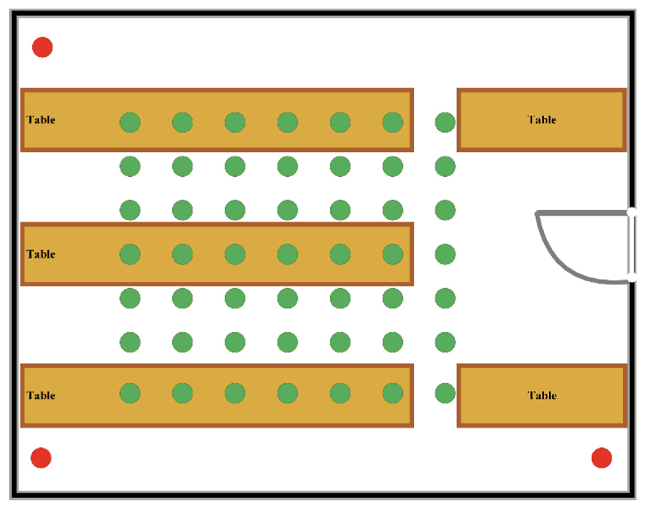
The dataset (consisting of three Excel files corresponding to Wi-Fi, Bluetooth, and ZigBee) is a comprehensive set of RSSI readings. The RSSI readings occurred in a 6.0 m × 5.5 m wide meeting room. Figure 3 overviews the experimental topologies performed in the room.
Three Anchor nodes (red), also known as transmitters, were placed 4 m apart from one another in the shape of a triangle. RSSI readings, at green dots, were taken with a 0.5 m spacing between the tag nodes in the center. This created around 49 RSSI readings for each wireless technology (Wi-Fi, Bluetooth, and ZigBee), comprising the database. In the figures, the red dots represent the location of the anchors, and the green dots represent the locations where RSSI readings were gathered. Green Dots indicate RSSI measurements taken at ground level and on top of tables, enabling experiments and tests to simulate various situations, such as the height at which a user would carry a device in their pocket. The experiment and result section contains a plot corresponding to Wi-Fi, Bluetooth, and ZigBee for this scenario.
The RSSI readings were obtained in a low-interference environment, specifically a small meeting room containing only tables and chairs to minimize unnecessary interference from other transmitting devices. The room’s dimensions were approximately 33 m2, measuring 6 m × 5.5 m. This real-world dataset, featured in [23], involved creating a dense fingerprint map for the environment by spacing points of interest 0.5 m apart in a grid pattern. The transmitters were positioned in a right-angle triangle with a 4 m spacing between them. This configuration aimed to simulate a typical office or classroom environment, where transmitters are placed at room corners, and the receiver is moved around. It also helped to create distinct signal strength patterns at various points within the room. We chose this real-world dataset to verify localization results when tag nodes are densely arranged.

5. Experiment and Results

This section presents the results of all the scenarios (experiments 1–3) mentioned in the methodology section. In every experiment conducted, numerous trials or iterations were performed. The total count of these trials depends on the variability in outcomes observed among consecutive iterations. As the variance becomes more stable and closely clustered, it suggests that an appropriate number of iterations has been reached.
We incorporate two key factors for more realistic simulations (localization of Wireless Sensor Network (WSN)): shadow effect and noise. The shadow effect simulates the signal attenuation caused by obstacles and environmental factors, while the noise accounts for random variations and uncertainties in the RSSI measurements. To create the shadow effect, we used a Python function that generates a 2D matrix with random values that follow a normal distribution. The matrix has a size of 100 × 100, equal to the simulation space. In this function, ‘0’ represents the mean and ‘2’ represents the standard deviation. We then incorporated the shadow effect by adding a specific random value from this matrix to the RSSI formula. This value is determined by using the position coordinates of the tag nodes as indices for the matrix. The RSSI formula calculates the RSSI from anchor nodes for that particular tag node. To introduce noise, we multiplied a noise factor with the random value generated by a random function. This provides a random noise component (ranging between 0 to 1) that is added to the RSSI measurements of each sensor node. For experiments 1 and 2, we used a noise factor of 1. All the experiments are performed on a cloud-based Google Colab GPU. We verified the performance of the localization techniques in terms of accuracy measured through the Mean Error and efficiency measured through the total time.

5.1. Results Related to Experiment 1

Experiment 1 provided a basic understanding of how our localization of tag nodes using different techniques (Multilateration, Grid-based RSS, and Centroid Algorithm) will look like. As discussed in experiment 1 of the methodology section, we estimated the position of tag nodes using the RSSI values recorded by four anchor nodes. These RSSI values were calculated using an internally generated dataset in Python script. The scatter plot in Figure 4a illustrates the distribution of tag nodes (green) in the simulation workspace (x-y coordinate plane). Figure 4a clearly visualizes the results (estimated position of tag nodes) provided by multilateration (blue triangle), grid-based RSS (purple X) and the centroid algorithm (yellow square).
Figure 4a shows that grid-based RSS has better localization accuracy compared to the centroid algorithm and multilateration. Furthermore, multilateration outperforms the centroid method. The reliance of the centroid method on geometric mean calculations for localizing randomly distributed tag nodes in a field results in poor performance. Inaccurate distance estimations and weight allocations for individual nodes arise due to irregular or sparse node distributions, leading to reduced localization accuracy.
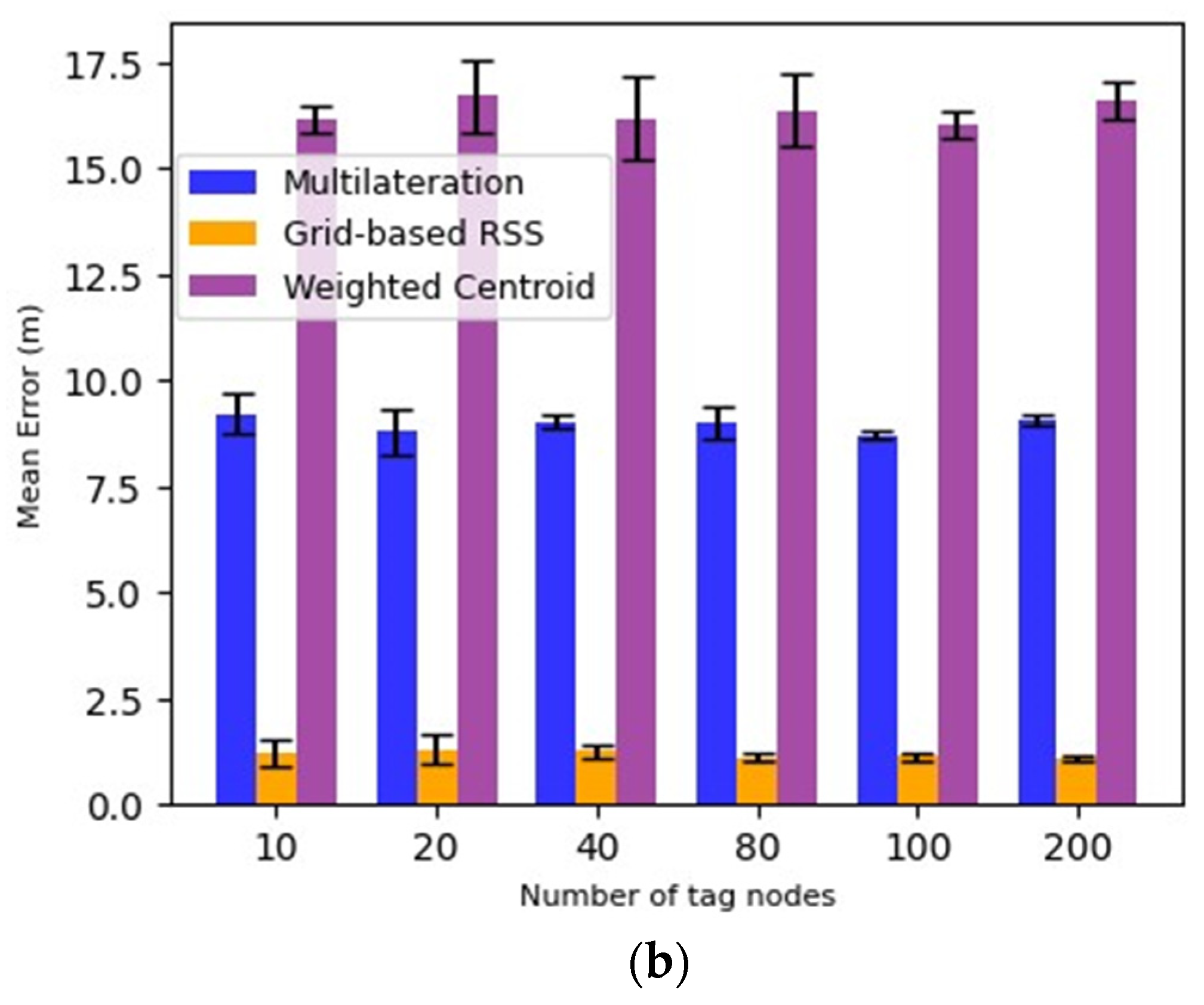
Figure 4b shows the mean error of localization for varying tag nodes. It shows that Grid-based RSS has the highest localization accuracy in this case (Experiment 1), irrespective of the number of tag nodes. Also, localization accuracy is stable (not fluctuating) for all three techniques as the number of tag nodes are changing. This shows the insensitivity against the number of tag nodes that participated in the experiment.

5.2. Results Related to Experiment 2

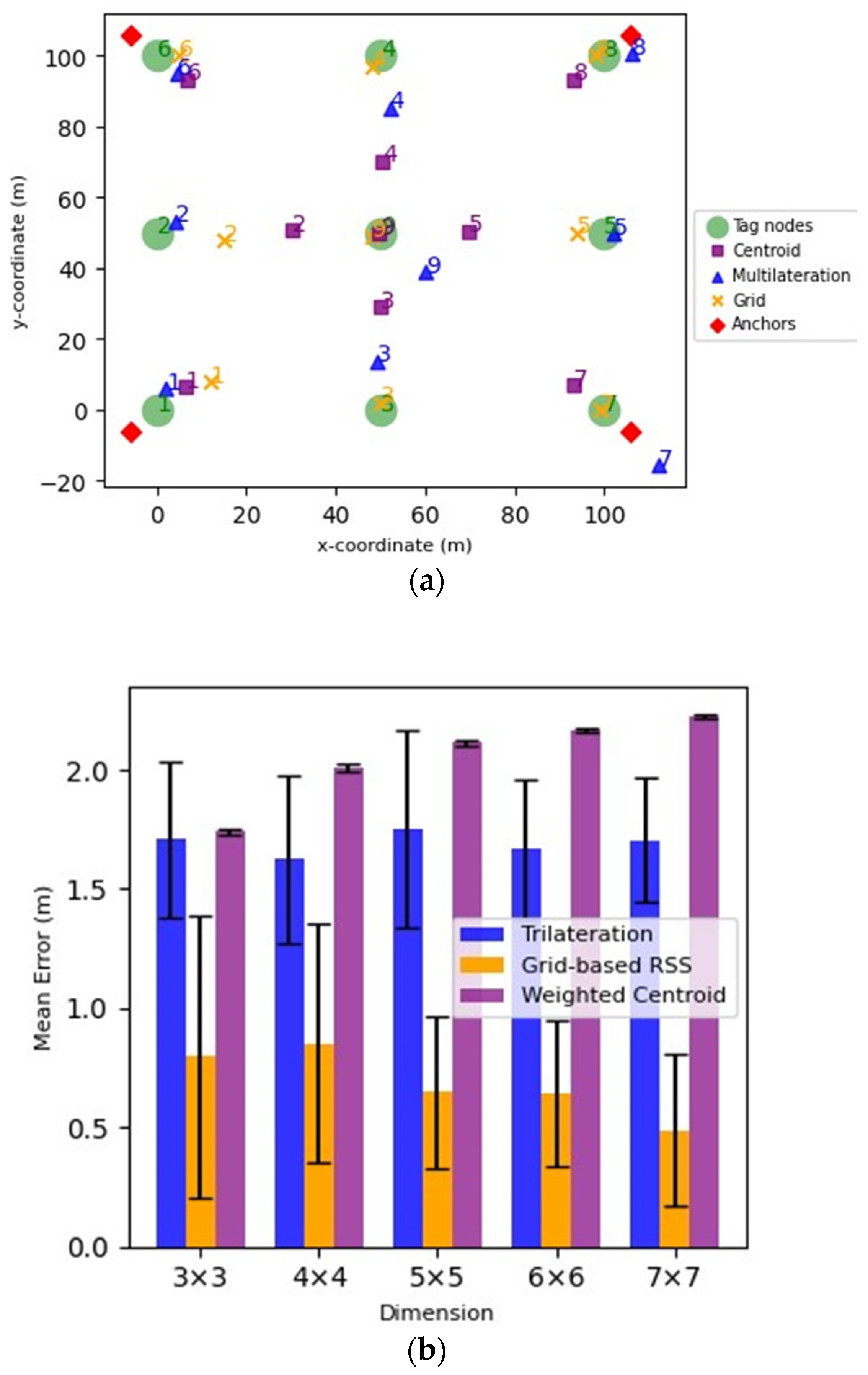
As discussed in the methodology section, we generated the dataset internally in our Python script for this experiment. We calculated the value for RSS0 using the Friis transmission equation [27]. This equation calculates the power an antenna receives based on the transmitted power, distance, and antenna gains. For other parameters like frequency, path loss exponent, transmitted power, and antenna gains, we used the values widely accepted in many wireless communication systems for convenience and practical reasons. Figure 5a below presents the localization results for multilateration, grid-based RSS, and centroid algorithms.
In Figure 5a, the estimated positions (blue, purple, and yellow) have numerical values corresponding to the actual node location (green). The node numbers help to identify the estimated tag node location for an actual tag node location. As per the plot, for more than half the number of tag nodes, multilateration (blue) has a highly accurate estimated location.

5.2.1. Dimension vs. Mean Error

As mentioned earlier, we conducted all the experimentation on the cloud-based Google Colab GPU. Figure 5b shows the localization accuracy of the three techniques as the dimension field expands (#Tag nodes across boundaries).
In Figure 5b, the Weighted Centroid Algorithm (purple) has less accuracy as compared to Multilateration (blue) and Grid-based RSS (yellow) regarding the estimated position of tag nodes. However, it localizes tag nodes placed at diagonals more accurately (as shown in Figure 5a) than tag nodes placed on edges or any other position. On the other hand, the centroid algorithm is robust to boundary increase as it has fewer fluctuations in localization results. Hence, the centroid algorithm is stable for dimension expansion.
Although Grid-based RSS boasts the highest localization accuracy, it also has a high standard deviation. This arises from its reliance on theoretical RSSI, which is recorded randomly within the simulation space to encourage realistic experimentation. The more theoretical RSSI readings taken, the better the localization accuracy, and vice versa.
The increased mean error for the weighted centroid stems from a growing number of tag nodes situated on the boundaries or edges of the simulation space. The weighted centroid algorithm localizes diagonally placed tag nodes more accurately than those in any other position. Thus, as tag nodes on boundaries or edges increase, so does the mean error. The mean error of multilateration remains steady as the dimension expands, indicating that this technique is not position-biased. It treats all tag nodes equally, regardless of their position.
Overall, in this boundary-setting experiment involving tag nodes, Grid-based RSS demonstrated the highest accuracy. Although the weighted centroid showed the lowest accuracy, it produced more consistent results, as indicated by a lower standard deviation.

5.2.2. Noise vs. Mean Error

Figure 6 shows the impact of noise on the localization accuracy of the three techniques. From Figure 6, we can conclude that the weighted centroid is more robust to noise than the other two techniques. Its localization error is similar at different noise levels, whereas Grid-based RSS is highly sensitive to noise. It also has the highest standard deviation due to its dependency on theoretical RSS. From noise levels 1 to 5, we can see grid-based RSS error has a greater mean error than the Multilateration, which in turn is less sensitive to noise than grid-based RSS. Its error difference is less than Grid-based RSS as noise increases from 1 to 5.

5.3. Results Related to Experiment 3

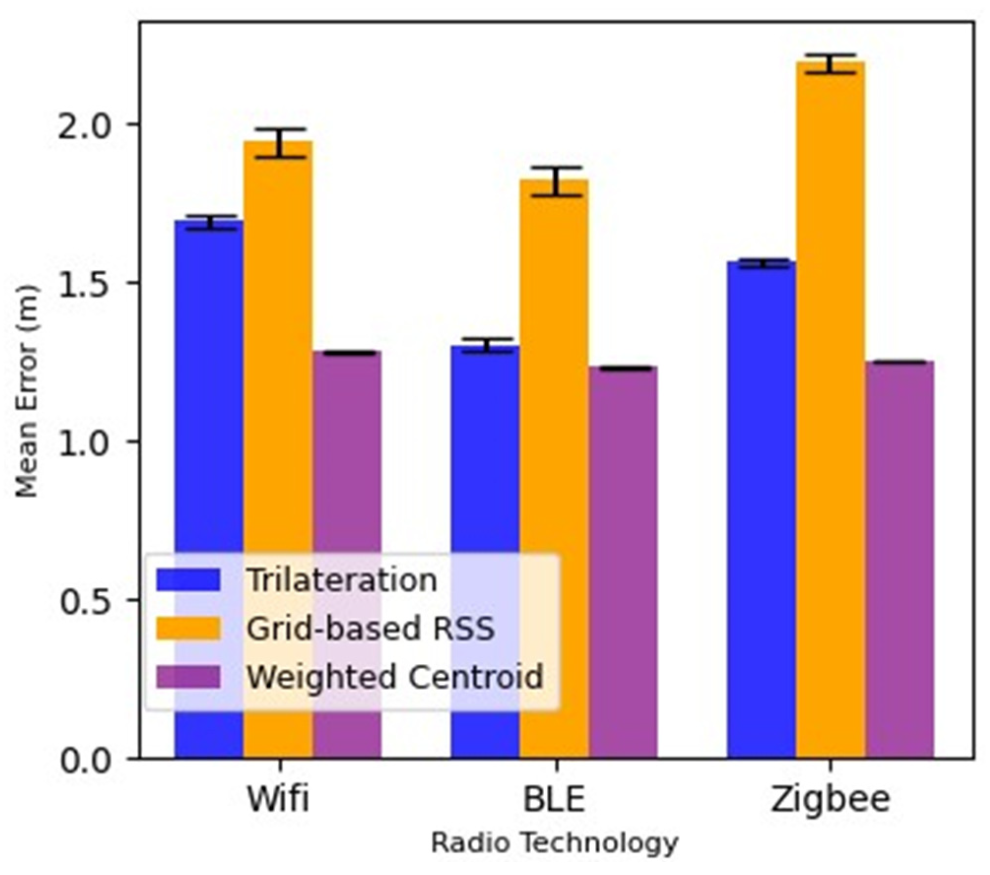
As discussed in the methodology section, experiment 3 is based on a publicly available real-world dataset. Three anchors were used to record the RSSI reading in a wide meeting room in Figure 3. The dataset captures RSSI observations from three wireless technologies (Wi-Fi, Bluetooth, and ZigBee). In this section, we discuss the results of the three localization techniques under these three different radio technologies. We have performed the localization for all the tag nodes, present in the dataset, in our Python script. The values of “RSS0” (received signal strength at a distance of 1 m) and “path-loss exponent” (the rate at which signal strength decreases with distance) are specific to the Wi-Fi hardware and environment being used in the experiment. We have plotted (Figure 7) the mean error of localization techniques (Trilateration, Grid-based RSS, and Centroid Algorithm) for each wireless technology. Through this plot, we can visualize the techniques with the highest performance. We iterated each experiment and calculated the localization error as the Euclidean distance between a tag node’s predicted and actual positions. So, the mean error is the average error for all the tag nodes. Figure 7 shows the results of the three localization techniques against the mean error for the three wireless technologies.
From Figure 7, we can conclude that the Weighted Centroid algorithm shows the highest localization accuracy. It has almost the same mean error in all three technologies. This shows that the Weighted Centroid algorithm performs well in the case of a limited number of anchor nodes (three in this case) and is more robust to noise or attenuation (path loss) than the other two techniques. The trilateration technique works well in the case of BLE when there is no unnecessary interference in the area or other transmitting devices. While in the other two technologies, it has higher errors than Weighted Centroid because of noise and limited anchors. Grid-based RSS has the highest localization error of all three technologies. This technique is very sensitive to noise compared to the other two techniques. It uses theoretical RSS to provide localization results. These factors contribute to its high localization error.

6. Discussion

The results from the three experiments provide valuable insights into the performance and accuracy of different localization techniques for WSNs using RSSI. We have observed that the localization techniques, namely Multilateration, Grid-based RSS, and Centroid Algorithm, have varied performance under different conditions and scenarios.
In Experiment 1, Grid-based RSS exhibited the highest localization accuracy among all three techniques evaluated, irrespective of the number of tag nodes. This outcome suggests that Grid-based RSS is more robust and less sensitive to changes in the number of tag nodes involved in the experiment. On the other hand, multilateration showed slightly lower accuracy than Grid-based RSS but still outperformed the Centroid Algorithm. The poor performance of the latter is attributed to its reliance on geometric mean calculations for estimating positions with irregular or sparse node distributions.
Experiment 2 reinforced the outcomes obtained from Experiment 1, confirming that multilateration provides accurate estimates for more than half of the tag nodes tested. Furthermore, it demonstrates that all three methods exhibit insensitivity toward fluctuations in the number of tag nodes involved. In analyzing the results of this experiment, it is obvious that the various localization techniques performed differently under different circumstances. Grid-based RSS demonstrated the highest accuracy in localizing tag nodes. However, this method has some limitations, such as its sensitivity to noise and higher standard deviation due to its reliance on theoretical RSSI. Increasing the number of theoretical RSSI’s could improve the localization accuracy. The weighted Centroid Algorithm displayed lower accuracy compared to Grid-based RSS and Multilateration, but was found to be more robust to noise with fewer fluctuations in the localization results. The algorithm was notably effective in localizing diagonally placed tag nodes. It is interesting to observe that its mean error increased as the number of tag nodes on the edges of the simulation space increased. Multilateration showed similar mean errors across increasing dimensions, suggesting that it is not position-biased and does not discriminate based on a tag node’s position. It is less sensitive to noise compared to Grid-based RSS but not as robust as the Weighted Centroid Algorithm regarding varying noise levels.
Experiment 3, using a real-world dataset and three different wireless technologies (Wi-Fi, Bluetooth, and ZigBee), revealed that the Weighted Centroid algorithm consistently produced the highest localization accuracy across all three technologies. While Grid-based RSS exhibits superior localization accuracy under certain conditions, the Weighted Centroid Algorithm provides more consistent results across various circumstances and technologies. Multilateration offers an unbiased performance without reliance on a tag node’s position. Therefore, it is essential to consider these characteristics when selecting an appropriate localization algorithm for specific applications.
Noise and shadow effect simulations in our experiments served to incorporate realistic conditions to better understand how these factors can influence localization performance. Despite these added complexities, the tested algorithms maintained stable accuracies and efficiencies through different iterations. Despite our study offering valuable perspectives on implementing localization techniques in WSNs concerning their accuracies, it is crucial to consider various parameters such as environmental conditions, deployment scenarios, and specific application requirements for choosing an optimal localization method best suited to a particular problem context.
We anticipate that our findings will also apply to three-dimensional (3D) scenarios for the following rationale.
(1)
Weighted centroid exhibits position bias:
  • If the localization accuracy of boundary nodes is higher than that of diagonal nodes in 3D, it implies that the weighted centroid is biased towards the position of the nodes.
  • If both edge nodes and diagonal nodes have the same accuracy, and the z-coordinate of diagonal nodes has higher error than edge nodes, while the xy-coordinate of diagonal nodes has less error than edge nodes, it also suggests that the weighted centroid is biased towards the position of the nodes.
  • If diagonal nodes have higher accuracy than edge nodes, it means that the weighted centroid localizes diagonal tag nodes more accurately than edge nodes. Consequently, this finding confirms the position bias of the weighted centroid in 3D.
Therefore, it is reasonable to assume that the weighted centroid is position-biased in 3D as well.
(2)
Weighted centroid is more robust to noise compared to the other two techniques:
The weighted centroid algorithm uses only RSSI information to localize tag nodes. Unlike multilateration, the weighted centroid algorithm does not need to calculate any distance value using the RSSI formula. It only utilizes the RSSI information as shown in the formula provided in Section 3.2.2. We should note that the anchor nodes record RSSI measurements based on the RSSI formula, which applies to both 2D and 3D scenarios. Therefore, this finding is also applicable to 3D environments.
(3)
Grid-based RSS is highly sensitive to noise and theoretical RSSI:
As demonstrated in experiment 2 in Section 5.2.2, the error of the grid-based RSS method increases at a higher rate compared to the other two techniques as the noise level increases from 1 to 5. Similar to the 2D case, the accuracy of the grid-based RSS in 3D heavily depends on the RSSI measurements. If the 3D environment has fluctuating noise levels, the grid-based RSS method will still yield higher localization errors (compared to the other techniques) due to its reliance on theoretical RSSI. Therefore, this finding is scalable to 3D scenarios.
(4)
Trilateration performs best in the BLE technology:
In 3D scenarios, multilateration requires a minimum of four anchors for accurate localization. The addition of another anchor will further minimize the MSE for all three technologies (BLE, WIFI, and ZIGBEE). Additionally, the multilateration algorithm utilizes RSSI values for position estimation. Even in 3D, the anchors record RSSI values in a similar manner as in 2D scenarios. This process also incorporates some noise or shadow effect represented by numerical values specific to each technology (BLE, WIFI, and ZIGBEE). Furthermore, trilateration is a geometric method that can be extended to three dimensions. Therefore, it is reasonable to assume that trilateration would also perform well in BLE applications in 3D.

7. Conclusions

Based on the simulations and analysis conducted in this study, we provided the strengths and weaknesses of the three localization techniques—Grid-based RSS, Multilateration, and Centroid Algorithm. Grid-based RSS demonstrated the highest localization accuracy but is sensitive to noise, and theoretical RSS and might not be ideal in scenarios with high fluctuations. Multilateration offered unbiased performance and was less sensitive to noise; however, it did not consistently outperform the other two techniques. The Weighted Centroid Algorithm showed impressive consistency across various conditions and technologies while maintaining reasonable localization accuracy. Thus, it is vital to consider each technique’s specific characteristics and potential applications when choosing a suitable localization algorithm for one’s needs.
One interesting finding from Experiment 3 was the superior performance of the Weighted Centroid Algorithm across all three wireless technologies. While it produced lower accuracy results compared to Grid-based RSS and multilateration in certain cases, its consistency across various conditions and technologies renders it a reliable choice for real-world scenarios. As wireless technologies continue to evolve rapidly, experiments such as these play an essential role in understanding which localization algorithms may be best suited for diverse applications and environments. Furthermore, these results encourage continuous research into refining and developing new techniques to improve localization accuracy and efficiently cater to diverse use cases in both indoor and outdoor settings.
In future work, we will explore performance enhancement through parallelization, noise-reducing correction techniques, and comparisons to Ultra-Wideband (UWB)-based localization systems for improved accuracy and effectiveness in indoor localization methods.

Author Contributions

Conceptualization, A.S., M.E. and Y.A.M.; Methodology, A.S. and M.E.; Software, A.S.; Validation, A.S., M.E. and Y.A.M.; Formal analysis, A.S. and Y.A.M.; Investigation, A.S. and M.E.; Resources, M.E.; Writing—original draft, A.S. and M.E.; Writing—review & editing, Y.A.M.; Visualization, M.E.; Supervision, Y.A.M.; Project administration, Y.A.M. All authors have read and agreed to the published version of the manuscript.

Funding

This research was funded by The University of Winnipeg grant number 19999.

Institutional Review Board Statement

Not applicable.

Informed Consent Statement

Not applicable.

Conflicts of Interest

The authors declare no conflict of interest.

References

  1. Bibbò, L.; Carotenuto, R.; Della Corte, F. An Overview of Indoor Localization System for Human Activity Recognition (HAR) in Healthcare. Sensors 2022, 22, 8119. [Google Scholar] [CrossRef] [PubMed]
  2. Chen, X.; Jia, Y. Indoor localization for mobile robots using lampshade corners as landmarks: Visual system calibration, feature extraction and experiments. Int. J. Control Autom. Syst. 2014, 12, 1313–1322. [Google Scholar] [CrossRef]
  3. Low, R.; Tekler, Z.D.; Cheah, L. An end-to-end point of interest (Poi) conflation framework. ISPRS Int. J. Geo-Inf. 2021, 10, 779. [Google Scholar] [CrossRef]
  4. Al Mtawa, Y. Towards Enhanced Location and Sensing Services for the Internet of Things. Canada—Ontario, CA. 2017. Available online: https://www.proquest.com/dissertations-theses/towards-enhanced-location-sensing-services/docview/1928875971/se-2?accountid=15067 (accessed on 29 July 2023).
  5. Yang, T.; Cabani, A.; Chafouk, H. A Survey of Recent Indoor Localization Scenarios and Methodologies. Sensors 2021, 21, 8086. [Google Scholar] [CrossRef] [PubMed]
  6. Sinha, S.; Ashwini, S. RSSI based improved weighted centroid localization algorithm in WSN. In Proceedings of the 2021 2nd International Conference for Emerging Technology (INCET 2021), Belgaum, India, 21–23 May 2021. [Google Scholar] [CrossRef]
  7. Raza, S.M.; Le, D.T.; Al Mtawa, Y.; Hassanein, H.S.; Nasser, N. Resilient Localization and Coverage in the Internet of Things. Electronics 2023, 12, 3172. [Google Scholar] [CrossRef]
  8. Podevijn, N.; Plets, D.; Trogh, J.; Karaagac, A.; Haxhibcqiri, J.; Hoebeke, J.; Martens, L.; Suanet, P.; Joseph, W. Performance Comparison of RSS Algorithms for Indoor Localization in Large Open Environments. In Proceedings of the IPIN 2018—9th International Conference on Indoor Positioning and Indoor Navigation, Nantes, France, 24–27 September 2018. [Google Scholar] [CrossRef]
  9. Liu, H.; Darabi, H.; Banerjee, P.; Liu, J. Survey of Wireless Indoor Positioning Techniques and Systems. IEEE Trans. Syst. Man Cybern. Part C (Appl. Rev.) 2007, 37, 1067–1080. [Google Scholar] [CrossRef]
  10. Xiao, J.; Zhou, Z.; Yi, Y.; Ni, L.M. A Survey on Wireless Indoor Localization from the Device Perspective. ACM Comput. Surv. 2016, 49, 1–31. [Google Scholar] [CrossRef]
  11. He, S.; Chan, S.-H.G. Wi-Fi Fingerprint-Based Indoor Positioning: Recent Advances and Comparisons. IEEE Commun. Surv. Tutor. 2016, 18, 466–490. [Google Scholar] [CrossRef]
  12. Hassan, N.U.; Naeem, A.; Pasha, M.A.; Jadoon, T.; Yuen, C. Indoor Positioning Using Visible LED Lights. ACM Comput. Surv. 2015, 48, 1–32. [Google Scholar] [CrossRef]
  13. Latif, E.; Parasuraman, R. Online Indoor Localization Using DOA of Wireless Signals. arXiv 2022, arXiv:2201.05105. Available online: https://arxiv.org/abs/2201.05105v1 (accessed on 29 July 2023).
  14. Gu, Y.; Lo, A.; Niemegeers, I. A survey of indoor positioning systems for wireless personal networks. IEEE Commun. Surv. Tutor. 2009, 11, 13–32. [Google Scholar] [CrossRef]
  15. Van Haute, T.; Rossey, J.; Becue, P.; De Poorter, E.; Moerman, I.; Demeester, P. A hybrid indoor localization solution using a generic architectural framework for sparse distributed wireless sensor networks. In Proceedings of the 2014 Federated Conference on Computer Science and Information Systems (FedCSIS 2014), Warsaw, Poland, 7–10 September 2014; pp. 1009–1015. [Google Scholar] [CrossRef]
  16. Tiglao, N.M.; Alipio, M.; Cruz, R.D.; Bokhari, F.; Rauf, S.; Khan, S.A. Smartphone-based indoor localization techniques: State-of-the-art and classification. Measurement 2021, 179, 109349. [Google Scholar] [CrossRef]
  17. Liu, L.; Li, B.; Yang, L.; Liu, T. Real-Time Indoor Positioning Approach Using iBeacons and Smartphone Sensors. Appl. Sci. 2020, 10, 2003. [Google Scholar] [CrossRef]
  18. Conte, G.; De Marchi, M.; Nacci, A.A.; Rana, V.; Sciuto, D. BlueSentinel: A first approach using iBeacon for an energy efficient occupancy detection system. In Proceedings of the BuildSys 2014—1st ACM Conference on Embedded Systems for Energy-Efficient Buildings, Association for Computing Machinery, Memphis, TN, USA, 5–6 November 2014; pp. 11–19. [Google Scholar] [CrossRef]
  19. Tekler, Z.D.; Low, R.; Gunay, B.; Andersen, R.K.; Blessing, L. A scalable Bluetooth Low Energy approach to identify occupancy patterns and profiles in office spaces. Build. Environ. 2020, 171, 106681. [Google Scholar] [CrossRef]
  20. Andò, B.; Baglio, S.; Crispino, R.; Marletta, V. An Introduction to Indoor Localization Techniques. Case of Study: A Multi-Trilateration-Based Localization System with User–Environment Interaction Feature. Appl. Sci. 2021, 11, 7392. [Google Scholar] [CrossRef]
  21. Priyadarshi, R.; Gupta, B.; Anurag, A. Deployment techniques in wireless sensor networks: A survey, classification, challenges, and future research issues. J. Supercomput. 2020, 76, 7333–7373. [Google Scholar] [CrossRef]
  22. Obeidat, H.; Shuaieb, W.; Obeidat, O.; Abd-Alhameed, R. A Review of Indoor Localization Techniques and Wireless Technologies. Wirel. Pers. Commun. 2021, 119, 289–327. [Google Scholar] [CrossRef]
  23. Sadowski, S.; Spachos, P.; Plataniotis, K.N. Memoryless Techniques and Wireless Technologies for Indoor Localization with the Internet of Things. IEEE Internet Things J. 2020, 7, 10996–11005. [Google Scholar] [CrossRef]
  24. Manolakis, D.E. Efficient solution and performance analysis of 3-D position estimation by trilateration. IEEE Trans. Aerosp. Electron. Syst. 1996, 32, 1239–1248. [Google Scholar] [CrossRef]
  25. Wang, Z.M.; Zheng, Y. The study of the weighted centroid localization algorithm based on RSSI. In Proceedings of the Proceedings—2014 International Conference on Wireless Communication and Sensor Network (WCSN 2014), Wuhan, China, 13–14 December 2014; pp. 276–279. [Google Scholar] [CrossRef]
  26. GitHub—Pspachos/RSSI-Dataset-for-Indoor-Localization-Fingerprinting: RSSI Dataset for Fingerprinting with Zigbee, BLE and WiFi. Available online: https://github.com/pspachos/RSSI-Dataset-for-Indoor-Localization-Fingerprinting (accessed on 29 July 2023).
  27. Cho, Y.H.; Byun, W.J. Generalized Friis Transmission Equation for Orbital Angular Momentum Radios. IEEE Trans. Antennas Propag. 2019, 67, 2423–2429. [Google Scholar] [CrossRef]
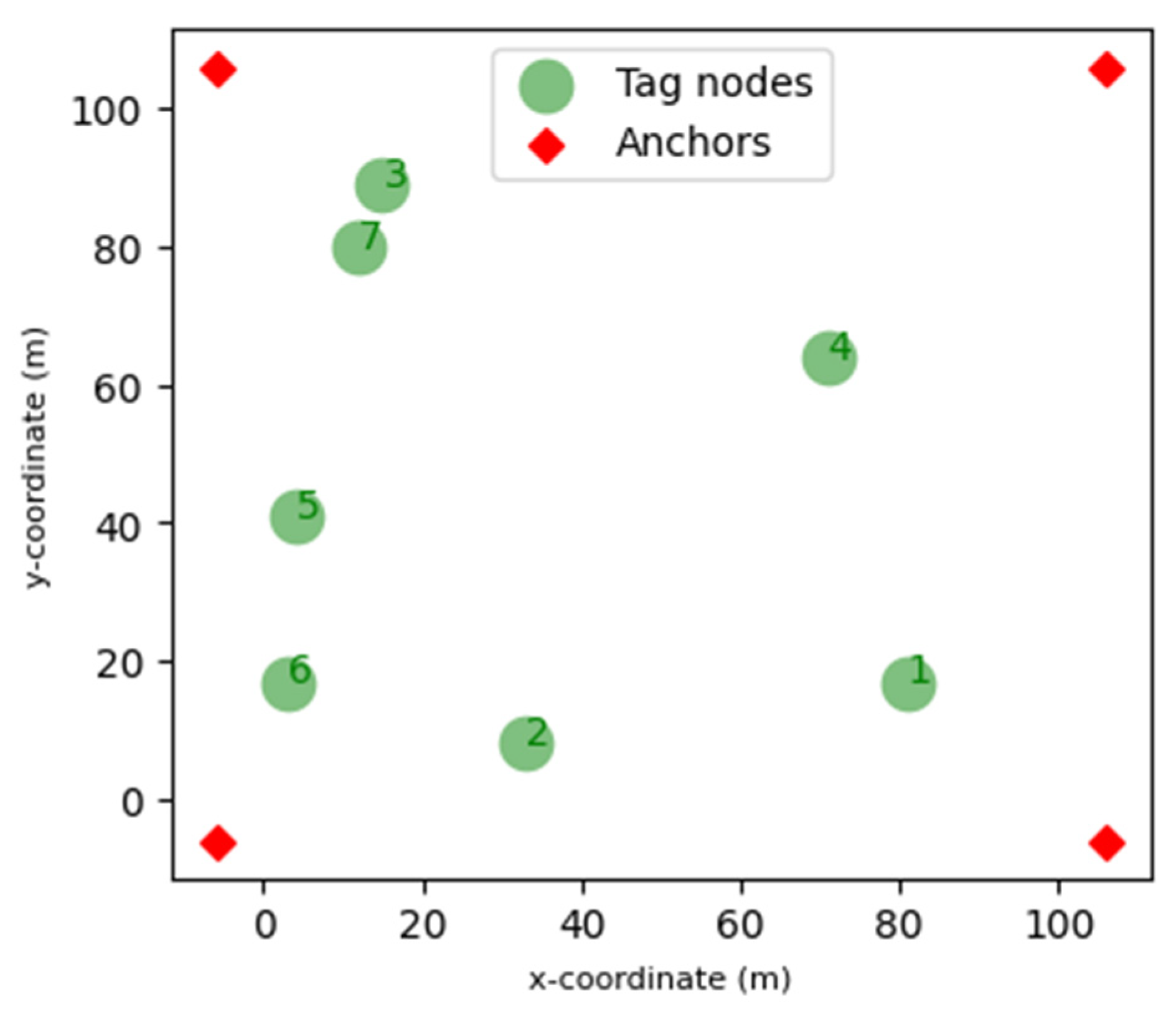
Figure 1. Seven randomly distributed tags and four anchor nodes are placed at the corners.
Eng 04 00131 g001
Figure 2. Nine boundary tags and four anchor nodes at the corners.
Eng 04 00131 g002
Figure 3. The testbed for experiment 3 features a room layout marked with 49 tags (green) and 3 anchors (red).
Eng 04 00131 g003
Figure 4. (a) Localization of seven randomly distributed tag nodes. (b) Tag nodes density vs. Mean Error.
Eng 04 00131 g004aEng 04 00131 g004b
Figure 5. (a) Localization of tag nodes across boundaries. (b) Localization techniques: Dimension (#Tag nodes across boundaries) vs. Mean Error.
Eng 04 00131 g005
Figure 6. Localization techniques: Noise vs. Mean Error.
Eng 04 00131 g006
Figure 7. Localization techniques: Radio Technology vs. Mean Error.
Eng 04 00131 g007
Table 1. An overview of most relevant related works in indoor localization.
Ref. No.Localization
Techniques Used
Wireless
Technology Used
Experimental
Settings
Parameter Settings
Tag Placement/Scalability
[13]PF-DOA, Weighted centroid, Markov Grid, Differential RSSWi-Fi, ZigBee and BLESimulation and two real-world datasetsConsider noise but not dimension; Random, boundary and diagonal tag placement
[15]Weighted centroid (range-based), Proximity-based (range-free)Wi-Fi, ZigBee, and BluetoothiMinds testbed/2 real-world environmentConsider tag placement and dimension
[17]Trilateration, FingerprintingBLEReal-time positioning experimentsConsider boundary tag placement
[18]BLE-based iBeaconBLEA real environment with a prototype systemConsider tag placement but not dimension
[19]Machine LearningBLETwo real-world datasets (2 different office areas with 650 m2 e and 248 m2) divided into zonesOccupancy density in irregular zones. Larger zones include more beacons to ensure signal coverage, with a total of 39 beacons
[23]K-Nearest Neighbor (KNN),
and Naive Bayes, Trilateration
Zigbee, BLE and Wi-FiThree real-world datasetsConsider interference levels; random and grid tag placement
Disclaimer/Publisher’s Note: The statements, opinions and data contained in all publications are solely those of the individual author(s) and contributor(s) and not of MDPI and/or the editor(s). MDPI and/or the editor(s) disclaim responsibility for any injury to people or property resulting from any ideas, methods, instructions or products referred to in the content.