Landslide Susceptibility Mapping in the Mount Elgon Districts of Eastern Uganda Using Google Earth Engine


Abstract
1. Introduction
2. Materials and Methods
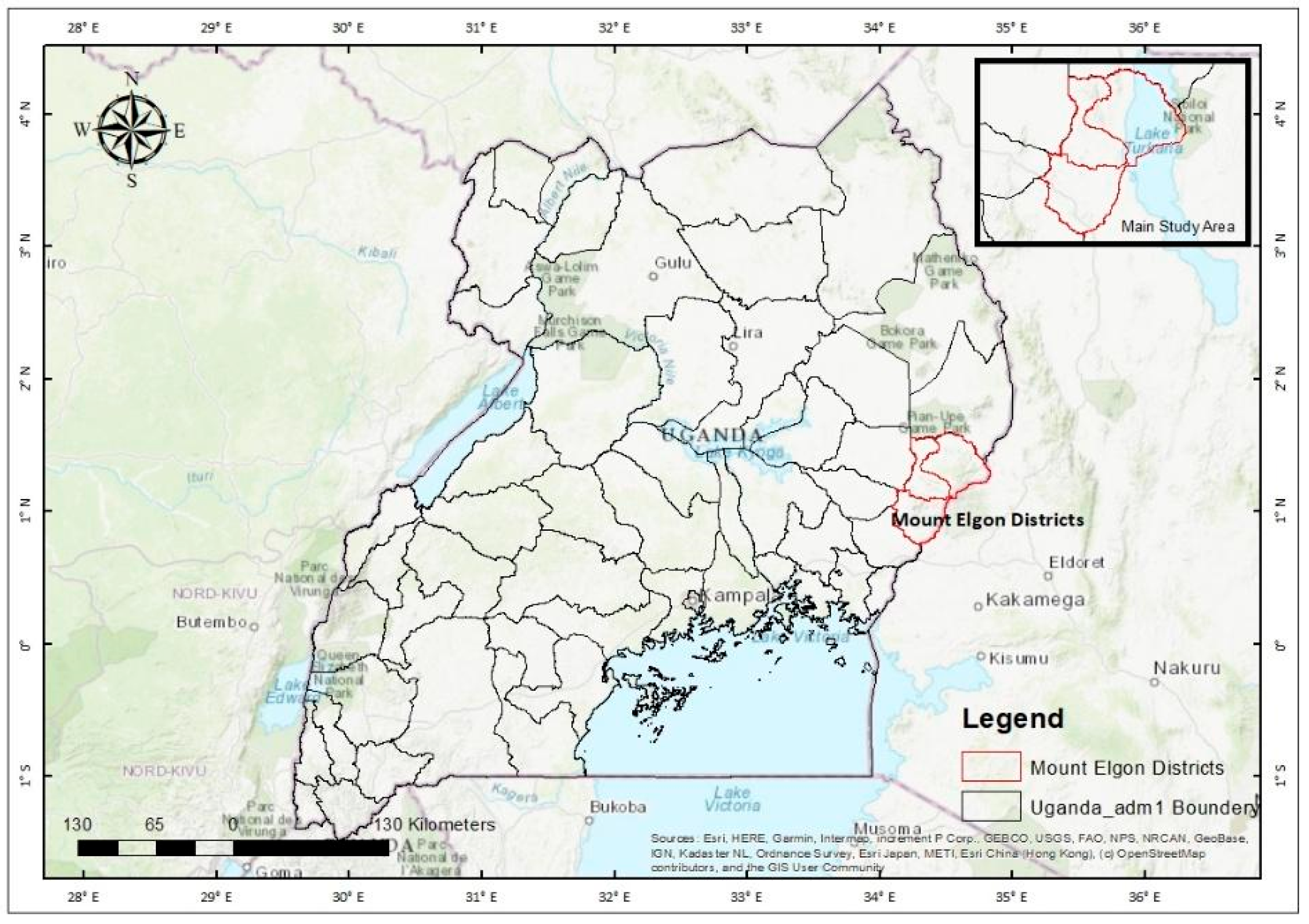
2.1. Study Area
2.2. Dataset Description and Sources
2.3. Landslide Conditioning Factor Preparation
2.4. Weighted Overlay Approach
2.5. Validation of Landslide Susceptibility Maps
3. Results
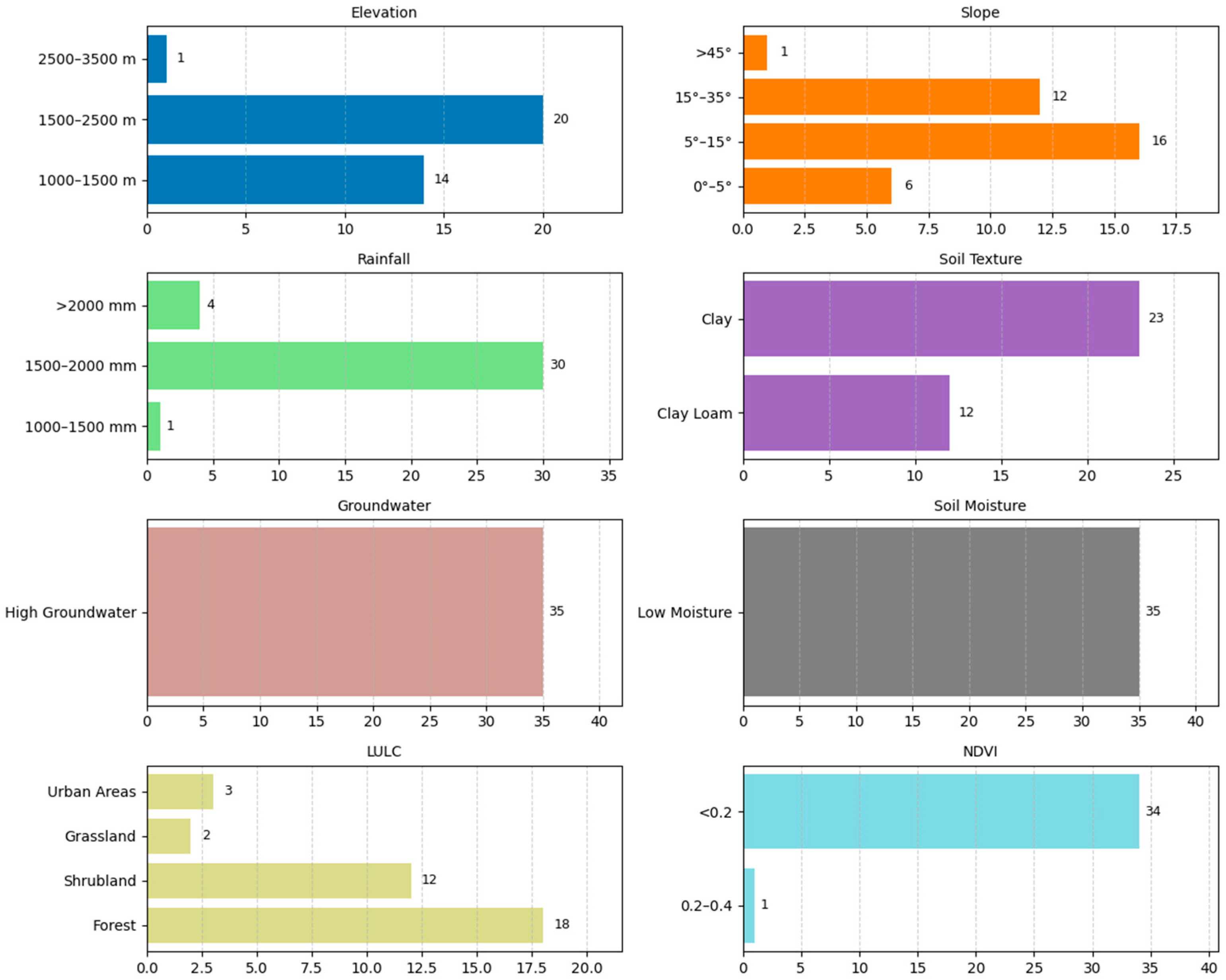
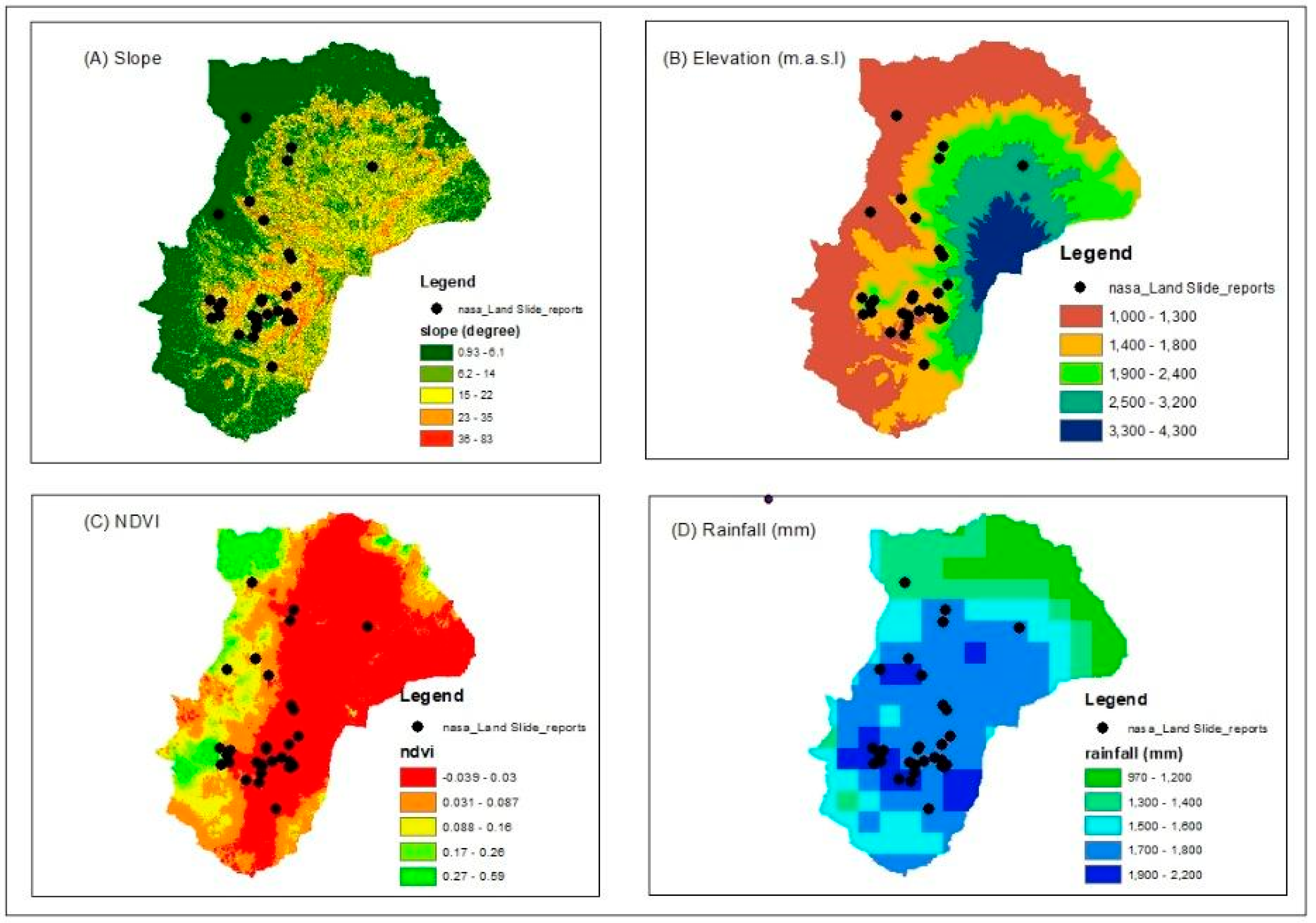
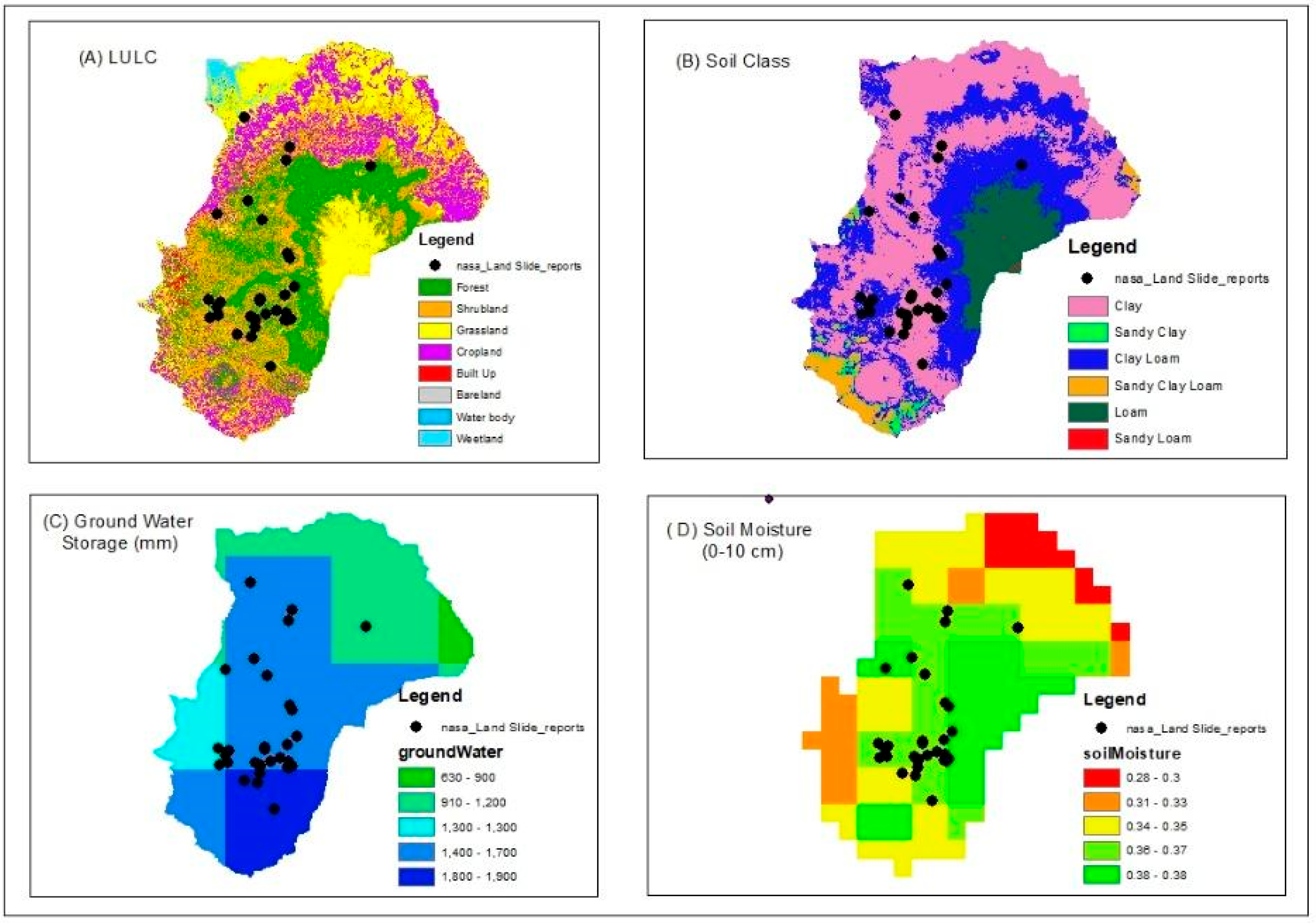
3.1. Landslide Conditioning Factors
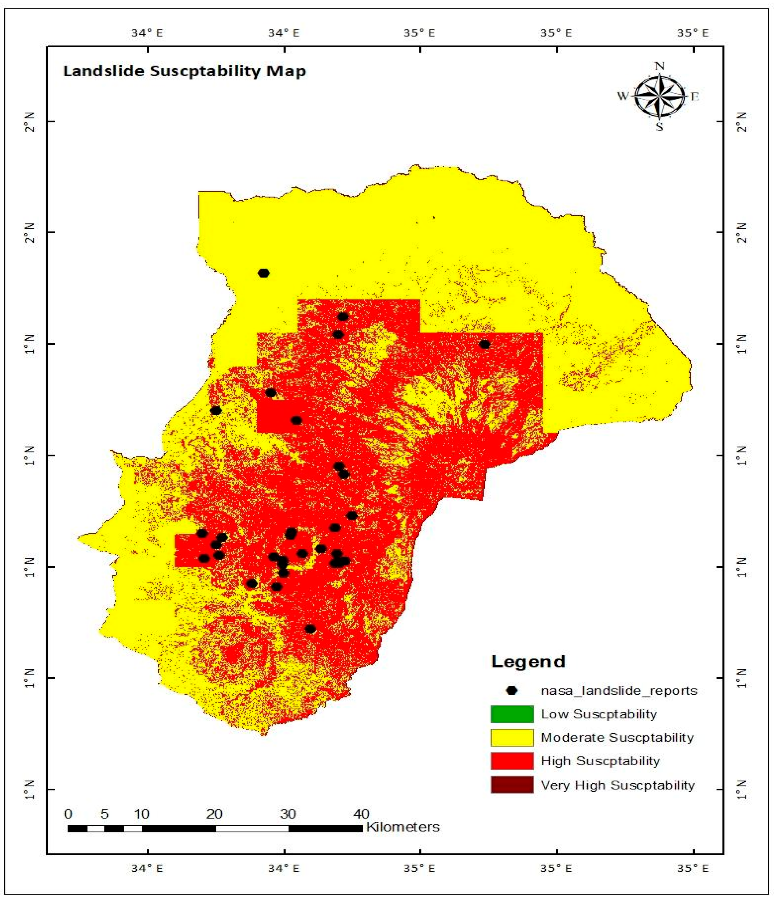
3.2. Landslide Susceptibility Mapping
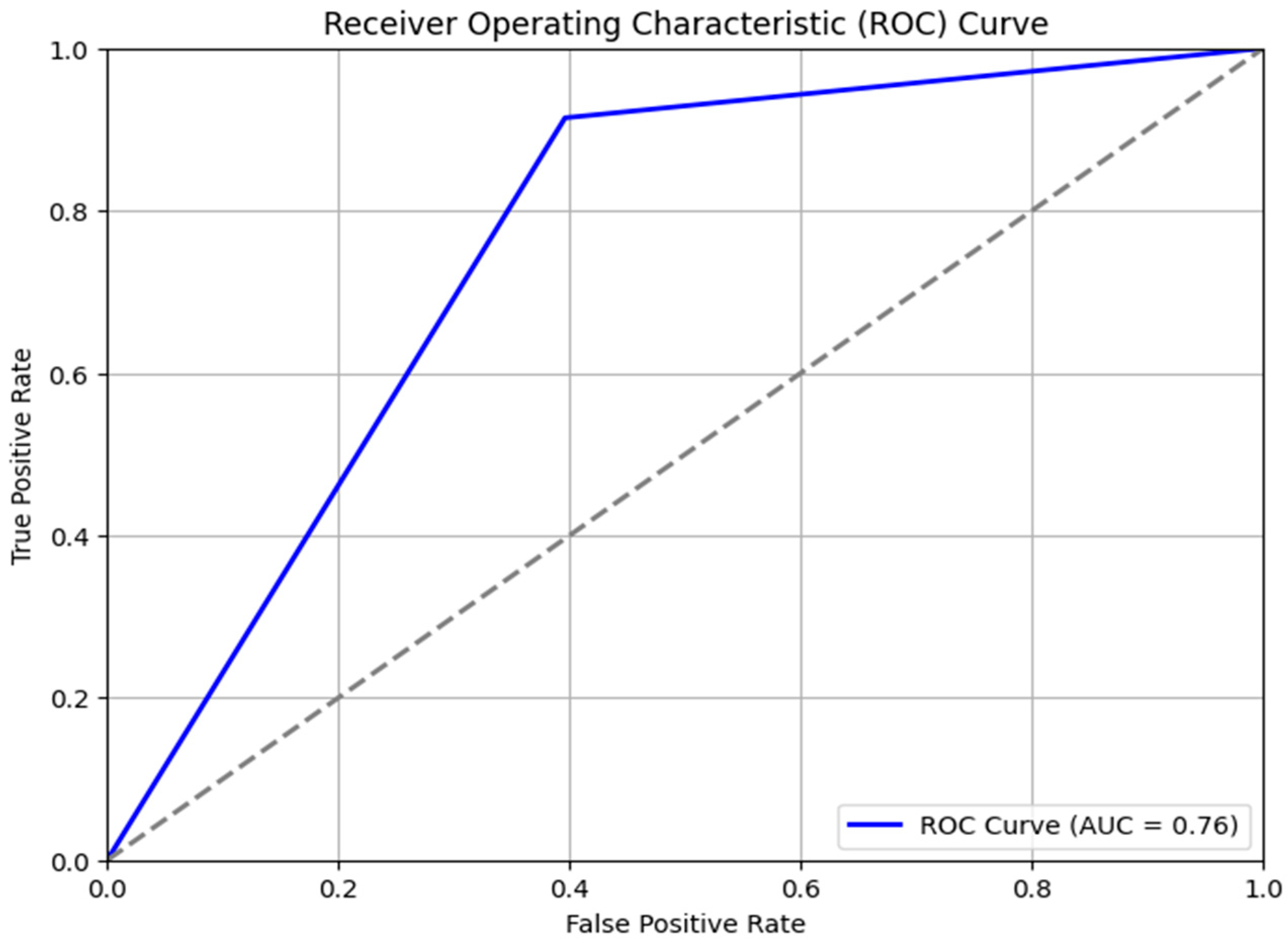
3.3. Validation of LSM Results
4. Discussion
5. Conclusions
Author Contributions
Funding
Data Availability Statement
Acknowledgments
Conflicts of Interest
References
- Zumpano, V.; Pisano, L.; Malek, Ž.; Micu, M.; Aucelli, P.P.; Rosskopf, C.M.; Parise, M. Economic losses for rural land value due to landslides. Front. Earth Sci. 2018, 6, 97. [Google Scholar] [CrossRef] [Scilit]
- Petley, D.N. Global patterns of loss of life from landslides. Geology 2012, 40, 927–930. [Google Scholar] [CrossRef] [Scilit]
- Haque, U.; Blum, P.; da Silva, P.F.; Andersen, P.; Pilz, J.; Chakraborty, S.; Chalov, S.R.; Malet, J.-P.; Auflič, M.J.; Andres, N.; et al. Fatal landslides in Europe. Landslides 2016, 13, 1545–1554. [Google Scholar] [CrossRef] [Scilit]
- Fidan, S.; Görüm, T. Türkiye’de ölümcül heyelanların dağılım karakteristikleri ve ulusal ölçekte öncelikli alanların belirlenmesi. Türk Coğrafya Derg. 2020, 74, 123–134. [Google Scholar] [CrossRef] [Scilit]
- Strouth, A.; McDougall, S. Historical landslide fatalities in British Columbia, Canada: Trends and implications for risk management. Front. Earth Sci. 2021, 9, 606854. [Google Scholar] [CrossRef] [Scilit]
- Centre for Research on the Epidemiology of Disasters (CRED). EM-DAT: The International Disaster Database; Université catholique de Louvain: Brussels, Belgium, 2024; Available online: https://www.emdat.be (accessed on 12 January 2025).
- Chae, B.G.; Park, H.J.; Catani, F.; Simoni, A.; Berti, M. Landslide prediction, monitoring, and early warning: A concise review of state-of-the-art. Geosci. J. 2017, 21, 1033–1070. [Google Scholar] [CrossRef] [Scilit]
- Nahayo, L.; Peng, C.; Lei, Y.; Tan, R. Spatial understanding of historical and future landslide variation in Africa. Nat. Hazards 2023, 119, 2463–2487. [Google Scholar] [CrossRef] [Scilit]
- Broeckx, J.; Maertens, M.; Isabirye, M.; Nakileza, B.; Vanmaercke, M. Landslide susceptibility and mobilization rates in the Mount Elgon region, Uganda. Landslides 2018, 16, 571–584. [Google Scholar] [CrossRef] [Scilit]
- Makonyo, T.; Zahor, L. GIS-based analysis of landslide susceptibility mapping: A case study of Lushoto District, north-eastern Tanzania. Nat. Hazards 2023, 118, 1085–1115. [Google Scholar] [CrossRef] [Scilit]
- Deijns, A.A.; Dewitte, O.; Thiery, W.; d’Oreye, N.; Malet, J.P.; Kervyn, F. Timing landslide and flash flood events from SAR satellite: A regionally applicable methodology illustrated in African cloud-covered tropical environments. Nat. Hazards Earth Syst. Sci. 2022, 22, 3679–3697. [Google Scholar] [CrossRef] [Scilit]
- Abdulahi, M.; Egli, M. Landslides triggered by the July 21–22, 2024, heavy rainfall in the Gofa Zone, Southern Ethiopia. Landslides 2024, 22, 267–270. [Google Scholar] [CrossRef] [Scilit]
- Opedes, H.; Nedala, S.; Mücher, C.; Baartman, J.; Mugagga, F. How Can Drones Uncover Land Degradation Hotspots and Restoration Hopespots? An Integrated Approach in the Mount Elgon Region with Community Perceptions. Land 2023, 12, 1. [Google Scholar] [CrossRef] [Scilit]
- Yang, K.; Niu, R.; Song, Y.; Dong, J.; Zhang, H.; Chen, J. Dynamic hazard assessment of rainfall-induced landslides using gradient boosting decision tree. Water 2024, 16, 1638. [Google Scholar] [CrossRef] [Scilit]
- Faisal, R.M.; Shehab, Z.N. Integrating GIS and comparative multi-criteria decision-making techniques for landslide susceptibility assessment. Prog. Phys. Geogr. 2025. [Google Scholar] [CrossRef] [Scilit]
- Farr, T.G.; Rosen, P.A.; Caro, E.; Crippen, R.; Duren, R.; Hensley, S.; Kobrick, M.; Paller, M.; Rodriguez, E.; Roth, L.; et al. The Shuttle Radar Topography Mission. Rev. Geophys. 2007, 45, RG2004. [Google Scholar] [CrossRef] [Scilit]
- Abatzoglou, J.T.; Dobrowski, S.Z.; Parks, S.A.; Hegewisch, K.C. TerraClimate: A high-resolution global dataset. Sci. Data 2018, 5, 170191. [Google Scholar] [CrossRef] [Scilit]
- Hengl, T. Soil texture classes (USDA system) for 6 soil depths (0, 10, 30, 60, 100 and 200 cm) at 250 m (Version v02) [Data set]. Zenodo 2018. [Google Scholar] [CrossRef]
- Zanaga, D.; Van De Kerchove, R.; Daems, D.; De Keersmaecker, W.; Brockmann, C.; Kirches, G.; Wevers, J.; Cartus, O.; Santoro, M.; Fritz, S.; et al. ESA WorldCover 10 m 2021 v200. 2022. Available online: https://zenodo.org/records/7254221 (accessed on 12 January 2025).
- Zanaga, D.; Bravo-López, E.R.; Delgado-García, J.; Sarmiento, L. Analysis of conditioning factors in Cuenca, Ecuador, for landslide susceptibility map generation employing machine learning methods. Land 2022, 12, 1135. [Google Scholar] [CrossRef] [Scilit]
- NASA Goddard Space Flight Center. Global Landslide Catalog (GLC). NASA. 2025. Available online: https://landslides.nasa.gov (accessed on 12 January 2025).
- Wiese, D.N.; Yuan, D.-N.; Boening, C.; Landerer, F.W.; Watkins, M.M. JPL GRACE and GRACE-FO Mascon Ocean, Ice, and Hydrology Equivalent Water Height JPL RL06.3Mv04. Ver. RL06.3Mv04. PO.DAAC, CA, USA. Available online: https://podaac.jpl.nasa.gov/dataset/TELLUS_GRAC-GRFO_MASCON_GRID_RL06.1_V3 (accessed on 12 January 2025).
- U.S. Geological Survey (USGS). Landsat 8 OLI/TIRS Level-2 Science Product, Path 042, Row 034; USGS Earth Resources Observation and Science (EROS) Center: Sioux Falls, SD, USA, 2013. Available online: https://earthexplorer.usgs.gov/ (accessed on 12 January 2025).
- Funk, C.; Peterson, P.; Landsfeld, M.; Pedreros, D.; Verdin, J.; Shukla, S.; Husak, G.; Rowland, J.; Harrison, L.; Hoell, A.; et al. The climate hazards infrared precipitation with stations—A new environmental record for monitoring extremes. Sci. Data 2015, 2, 150066. [Google Scholar] [CrossRef] [Scilit] [PubMed]
- Khatun, M.; Hossain, A.S.; Sayem, H.M.; Moniruzzaman, M.; Ahmed, Z.; Rahaman, K.R. Landslide susceptibility mapping using weighted-overlay approach in Rangamati, Bangladesh. Earth Syst. Environ. 2023, 7, 223–235. [Google Scholar] [CrossRef] [Scilit]
- Ali, S.A.; Parvin, F.; Vojteková, J.; Costache, R.; Linh, N.T.T.; Pham, Q.B.; Vojtek, M.; Gigović, L.; Ahmad, A.; Ghorbani, A.M. GIS-based landslide susceptibility modeling: A comparison between fuzzy multi-criteria and machine learning algorithms. Geosci. Front. 2021, 12, 857–876. [Google Scholar] [CrossRef] [Scilit]
- Basharat, M.; Rohn, J.; Baig, M.S.; Khan, M.R. Spatial distribution analysis of mass movements triggered by the 2005 Kashmir earthquake in the Northeast Himalayas of Pakistan. Geomorphology 2014, 206, 203–214. [Google Scholar] [CrossRef] [Scilit]
- Babitha, G.; Shweta, V.; Sameena, P.; Silvia Raquel, G.B. Machine learning based landslide susceptibility mapping models and GB-SAR based landslide deformation monitoring systems: Growth and evolution. Remote Sens. Appl. Soc. Environ. 2023, 29, 100905. [Google Scholar] [CrossRef] [Scilit]
- Dashbold, B.; Bryson, L.S.; Crawford, M.M. Landslide hazard and susceptibility maps derived from satellite and remote sensing data using limit equilibrium analysis and machine learning model. Nat. Hazards 2023, 116, 235–265. [Google Scholar] [CrossRef] [Scilit]
- Di Napoli, M.; Tanyas, H.; Castro-Camilo, D.; Calcaterra, D.; Cevasco, A.; Di Martire, D.; Pepe, G.; Brandolini, P.; Lombardo, L. On the estimation of landslide intensity, hazard and density via data-driven models. Nat. Hazards 2023, 119, 1513–1530. [Google Scholar] [CrossRef] [Scilit]
- Shano, L.; Raghuvanshi, T.K.; Meten, M. Landslide susceptibility evaluation and hazard zonation techniques—A review. Geoenviron. Disasters 2020, 7, 18. [Google Scholar] [CrossRef] [Scilit]
- Murgia, I.; Vitali, A.; Giadrossich, F.; Tonelli, E.; Baglioni, L.; Cohen, D.; Schwarz, M.; Urbinati, C. Effects of Land Cover Changes on Shallow Landslide Susceptibility Using SlideforMAP Software (Mt. Nerone, Italy). Land 2024, 13, 1575. [Google Scholar] [CrossRef] [Scilit]
- Zhao, Z.; Liu, Z.Y.; Xu, C. Slope unit-based landslide susceptibility mapping using certainty factor, support vector machine, random forest, CF-SVM and CF-RF models. Front. Earth Sci. 2021, 9, 589630. [Google Scholar] [CrossRef] [Scilit]
- Nakileza, B.R.; Nedala, S. Topographic influence on landslides characteristics and implication for risk management in upper Manafwa catchment, Mt Elgon Uganda. Geoenviron. Disasters 2020, 7, 27. [Google Scholar] [CrossRef] [Scilit]
- Ali, S.A.; Khatun, R.; Ahmad, A.; Ahmad, S.N. Assessment of cyclone vulnerability, hazard evaluation and mitigation capacity for analyzing cyclone risk using GIS technique: A study on Sundarban biosphere reserve, India. Earth Syst. Environ. 2020, 4, 71–92. [Google Scholar] [CrossRef] [Scilit]
- Jayakody, S.H.S.; Uzuoka, R.; Ueda, K. Effect of groundwater dynamics in rain-induced landslides: Centrifuge and numerical study. Soils Found. 2024, 64, 101482. [Google Scholar] [CrossRef] [Scilit]
- Jacobs, L.; Dewitte, O.; Poesen, J.; Maes, J.; Mertens, K.; Sekajugo, J.; Kervyn, M. Landslide characteristics and spatial distribution in the Rwenzori Mountains, Uganda. J. Afr. Earth Sci. 2017, 134, 917–930. [Google Scholar] [CrossRef] [Scilit]
- Shahabi, H.; Hashim, M. Landslide susceptibility mapping using GIS-based statistical models and Remote sensing data in tropical environment. Sci. Rep. 2015, 5, 9899. [Google Scholar] [CrossRef] [Scilit] [PubMed]



| Condition Factor | Source | Resolution | Dataset Name/Platform | Derived From | Notes/Purpose |
|---|---|---|---|---|---|
| Elevation | [16] | 30 m | SRTM (USGS/SRTMGL1_003) | - | Topographic factor for slope and TPI derivation |
| Slope | Derived from DEM (SRTM) | 30 m | - | DEM (SRTM) | Indicates terrain steepness, a key landslide driver |
| Soil Texture | [18] | 250 m | OpenLandMap/SOL/SOL_TEXTURE … | - | Affects infiltration and slope stability |
| Groundwater | [21] | 25 km | NASA/GLDAS/V022/CLSM/G025/DA1D | - | Indicates subsurface water presence |
| Soil Moisture | [22] | 10 km | NASA/FLDAS/NOAH01/C/GL/M/V001 | - | Used to evaluate water saturation in soil |
| Land Use Land Cover | [19] | 10 m | ESA WorldCover 2020 | - | Shows anthropogenic vs. natural coverage |
| NDVI | [23] | 30 m | Landsat 8 (LC08/C02/T2_L2) | Landsat imagery | Proxy for vegetation cover and root cohesion |
| Rainfall | [24] | 5 km | CHIRPS (UCSB-CHG/CHIRPS/PENTAD) | - | Major trigger for rainfall-induced landslides |
| Landslide Susceptibility Class | Area (Sq. km) | Percentage (%) |
|---|---|---|
| Very High Risk | 0 | 0 |
| High Risk | 1590 | 37.7 |
| Moderate Risk | 2453 | 58 |
| Low Risk | 85 | 2 |
| Very Low Risk | 95 | 2.3 |
| Total | 4223 | 100% |
| Landslide Susceptibility Class | Landslides |
|---|---|
| Very High Risk | 0 |
| High Risk | 34 |
| Moderate Risk | 1 |
| Low Risk | 0 |
| Very Low Risk | 0 |
| Total | 35 |
Disclaimer/Publisher’s Note: The statements, opinions and data contained in all publications are solely those of the individual author(s) and contributor(s) and not of MDPI and/or the editor(s). MDPI and/or the editor(s) disclaim responsibility for any injury to people or property resulting from any ideas, methods, instructions or products referred to in the content. |
© 2026 by the authors. Licensee MDPI, Basel, Switzerland. This article is an open access article distributed under the terms and conditions of the Creative Commons Attribution (CC BY) license.
Share and Cite
Abdulahi, M.M.; Egli, P.E.; Bora, Z. Landslide Susceptibility Mapping in the Mount Elgon Districts of Eastern Uganda Using Google Earth Engine. GeoHazards 2026, 7, 50. https://doi.org/10.3390/geohazards7020050
Abdulahi MM, Egli PE, Bora Z. Landslide Susceptibility Mapping in the Mount Elgon Districts of Eastern Uganda Using Google Earth Engine. GeoHazards. 2026; 7(2):50. https://doi.org/10.3390/geohazards7020050
Chicago/Turabian StyleAbdulahi, Mohammed Mussa, Pascal E. Egli, and Zinabu Bora. 2026. "Landslide Susceptibility Mapping in the Mount Elgon Districts of Eastern Uganda Using Google Earth Engine" GeoHazards 7, no. 2: 50. https://doi.org/10.3390/geohazards7020050
APA StyleAbdulahi, M. M., Egli, P. E., & Bora, Z. (2026). Landslide Susceptibility Mapping in the Mount Elgon Districts of Eastern Uganda Using Google Earth Engine. GeoHazards, 7(2), 50. https://doi.org/10.3390/geohazards7020050