1. Introduction
Armenia is located within the central segment of the Arabia–Eurasia continental collision zone, one of the most tectonically active regions of the Alpine–Himalayan belt. The present-day tectonic structure of the region results from the accretion of continental fragments to the southern margin of Eurasia during the Late Cretaceous–Early Cenozoic [
1,
2]. Ongoing convergence between the Arabian and Eurasian plates continues to generate active crustal deformation across the Lesser Caucasus.
Present-day deformation in the region is mainly accommodated by strike-slip faulting, locally associated with transpressional and transtensional regimes. The regional fault network is characterized by several dominant structural trends, including NW–SE right-lateral strike-slip faults, NE–SW left-lateral strike-slip faults, E–W reverse faults, and N–S normal faults. The interaction of these fault systems results in significant seismic activity and contributes to moderate-to-high seismic hazard levels across Armenia [
3,
4].
The Mw 6.9 Spitak earthquake of 7 December 1988 represents the most destructive recent seismic event in Armenia, causing extensive human and economic losses. The disaster revealed important limitations in previous seismic hazard assessments and construction practices, emphasizing the need for improved seismic hazard evaluation and risk mitigation strategies.
Following this event, systematic investigations of active faults, paleoseismology, and seismic hazard were initiated in Armenia. The Armenian National Survey for Seismic Protection (NSSP) was established to coordinate national seismic risk reduction efforts, and a probabilistic seismic zonation map based on peak ground acceleration (PGA) was introduced in 1998 [
5]. Armenian researchers have also contributed to several international seismic hazard initiatives, including the Global Seismic Hazard Assessment Program (GSHAP) [
6] and the European–Mediterranean Seismic Hazard Model (EMME14) [
7].
More recently, between 2016 and 2018, a comprehensive probabilistic seismic hazard assessment (PSHA) for Armenia was conducted within the SHARA17 project commissioned by the Armenian National Seismic Protection Service and supported by the World Bank [
8]. This project integrated active fault data, historical and instrumental seismicity, and modern ground-motion models within a logic-tree framework.
Building upon these previous efforts, the present study develops an updated probabilistic seismic hazard assessment for Armenia based on an integrated seismotectonic framework incorporating active fault data, historical and instrumental seismicity, and paleoseismological constraints. The resulting hazard maps provide improved spatial resolution of peak ground acceleration and contribute to a more robust scientific basis for seismic hazard assessment, seismic zonation, and earthquake risk mitigation in Armenia.
This study represents the outcome of a long-term collaborative effort aimed at improving the seismic hazard assessment framework for Armenia. It integrates geological, seismotectonic, and seismological data within a unified probabilistic framework to provide an updated seismic hazard model for the region.
Compared to previous seismic hazard assessments for Armenia, including SHARA17, GSHAP, and EMME14, the present study provides a substantial methodological and data-driven update. In particular, this work integrates an updated and homogenized earthquake catalog, incorporates refined active fault and paleoseismological datasets, and implements a hybrid seismic source model combining fault-based characteristic events with distributed background seismicity. Furthermore, the use of a comprehensive logic-tree framework enables explicit treatment of epistemic uncertainty in both seismic source characterization and ground-motion prediction. These advances result in a more robust, higher-resolution, and physically consistent seismic hazard model for Armenia.
Although no new primary geological or paleoseismological data were collected, this study provides an updated seismic hazard model through the integration and critical re-evaluation of multiple existing datasets within a unified probabilistic framework. The added value of the present work lies in the harmonization of heterogeneous data sources, the revision of fault source parameters based on published studies, and the implementation of a transparent logic-tree structure in OpenQuake. These improvements result in a more consistent and regionally adapted representation of seismic sources and associated uncertainties compared to previous assessments.
Recent years have seen significant advances in probabilistic seismic hazard assessment (PSHA) and seismic hazard mapping methodologies worldwide. Several recent studies have emphasized the integration of multi-source datasets, improved treatment of epistemic uncertainty through logic-tree frameworks, and the application of advanced ground-motion models in regional hazard assessments [
9,
10,
11].
In particular, recent developments include the use of region-specific GMPEs, hybrid seismic source models combining fault-based and distributed seismicity, and high-resolution hazard mapping approaches that enhance the reliability of seismic hazard estimates [
9,
10,
11,
12]. These methodological advances provide an important context for the present study, which applies similar integrated approaches to the Armenia region.
Recent advances in seismic fragility and performance-based assessment of infrastructure highlight the importance of reliable seismic hazard characterization for engineering applications. In particular, studies focusing on underground structures, such as shield tunnels in liquefiable and non-liquefiable soils, demonstrate that detailed hazard models are essential for predicting structural response and estimating seismic demand [
13,
14].
In this context, the probabilistic seismic hazard results obtained in this study provide a necessary basis for future seismic fragility and risk assessments in Armenia, supporting the development of more resilient infrastructure and improved risk mitigation strategies.
2. Tectonic Setting
Armenia is located within the Lesser Caucasus and forms part of the central segment of the Arabia–Eurasia continental collision zone. The northward motion of the Arabian Plate relative to Eurasia occurs at a present-day rate of approximately 15–20 mm/yr, as constrained by GPS measurements [
3,
15]. This convergence is distributed across a broad deformational region that includes eastern Turkey, Armenia, Georgia, and northwestern Iran.
The onset of the Arabia–Eurasia continental collision is generally attributed to the Miocene, with progressive crustal shortening and thickening continuing to the present day [
1]. Deformation in Armenia is accommodated by a combination of strike-slip, reverse, and normal faulting, reflecting strain partitioning within the continental collision zone. Most major active faults exhibit strike-slip kinematics, often accompanied by secondary compressional or extensional components.
The regional fault network is characterized by several dominant structural trends:
NW–SE right-lateral strike-slip systems, including the Pambak–Sevan–Syunik Fault System (PSSF);
NE–SW left-lateral strike-slip structures;
E–W-oriented reverse faults;
N–S-oriented normal faults.
Among these structures, the Pambak–Sevan–Syunik Fault System (PSSF) represents one of the principal tectonic features controlling seismicity in Armenia. Geological and paleoseismological investigations indicate slip rates ranging from approximately 0.5 to 4 mm/yr along major fault segments [
4,
16].
Historical and paleoseismological evidence suggests repeated occurrence of large earthquakes (Mw ≥ 7.0) along these fault systems. At least nine earthquakes with magnitudes of 7 or greater have affected Armenia and adjacent regions since 1500 AD [
4]. Paleoseismological trenching studies along segments of the PSSF and the Garni Fault reveal evidence of prehistoric surface-rupturing earthquakes with estimated magnitudes in the range of Mw 7.0–7.4 [
2].
Seismicity in Armenia is predominantly shallow crustal, with focal depths generally less than 25 km, consistent with brittle deformation of the upper crust. However, intermediate-depth seismicity is locally observed and likely reflects more complex lithospheric processes within the broader Arabia–Eurasia collision zone.
Overall, the tectonic framework of Armenia is characterized by distributed deformation, active strike-slip fault systems, and significant strain accumulation, which together control the spatial distribution of seismic hazard across the region.
The seismotectonic database used in this study was compiled through an integration of published data and original analysis. Fault geometry and kinematic parameters were primarily derived from published seismotectonic and geological studies [
2,
16], complemented by regional tectonic models [
3], which provide robust constraints on active fault systems in Armenia and the surrounding region. These data were critically reviewed, harmonized, and incorporated into a unified framework.
In addition, the authors performed original processing and interpretation, including the integration of heterogeneous datasets, the development of a consistent fault-source model, and the implementation of the logic-tree structure for probabilistic seismic hazard assessment.
No new field geological investigations or paleoseismological trenching were conducted as part of this study. Instead, previously published paleoseismological and geological data were systematically compiled and evaluated. The seismicity catalog was also reprocessed by the authors, including magnitude homogenization, declustering, and completeness analysis, to ensure consistency and suitability for hazard calculations.
This integrated approach allows for a comprehensive and regionally consistent seismic hazard model, combining existing knowledge with new methodological implementation.
3. Data and Methods
3.1. Earthquake Catalog
A comprehensive earthquake catalog was compiled by integrating historical, instrumental, and modern digital seismic records in order to provide a consistent database for probabilistic seismic hazard assessment. The historical component includes earthquakes documented since approximately 100 CE, derived from regional seismic catalogs, historical chronicles, and archival sources.
Instrumental observations in Armenia began in 1932, following the installation of the first seismic station in the country. These early instrumental records significantly improved the reliability of earthquake location and magnitude estimation compared with historical sources.
The modern digital period reflects major improvements in seismic monitoring resulting from the expansion of regional seismic networks and the deployment of broadband seismic instrumentation. These developments have substantially enhanced earthquake detection capability, magnitude determination, and hypocenter location accuracy.
The integrated earthquake catalog therefore combines long-term historical information with modern high-quality seismic observations, providing a robust dataset for seismicity analysis and probabilistic seismic hazard modeling.
3.1.1. Archeoseismicity and Paleoseismicity Database
Paleoseismological investigations have identified evidence of numerous prehistoric earthquakes with magnitudes in the range Mw 7.0–7.4 along the Pambak–Sevan–Syunik Fault System (PSSF) and the Garni Fault (GF) [
2,
17,
18,
19,
20]. The ages and principal characteristics of these paleoearthquakes were primarily constrained using radiocarbon (
14C) dating of organic materials collected from trench exposures.
In addition, archeological artifacts uncovered during trenching investigations were analyzed to further constrain the timing of paleoearthquake events [
2,
18]. Vertical and oblique displacements observed in trench sections were measured and used, together with empirical relationships between surface rupture parameters and earthquake magnitude proposed by Wells and Coppersmith [
21], to estimate the magnitudes of paleoearthquakes. In some cases, magnitude estimates were also evaluated using displacement-based approaches following Hanks and Kanamori [
22].
Archeoseismological investigations have provided important evidence for previously unrecognized earthquakes that occurred between the Early Bronze Age and the Ancient and Urartian periods. These studies were conducted primarily by the Institute of Geological Sciences of the National Academy of Sciences of Armenia (NAS RA) and GEORISK Scientific Research Company, often in collaboration with international research teams.
3.1.2. Historical and Instrumental Seismicity Database
Historical earthquakes that occurred prior to the instrumental recording period were compiled from written historical chronicles, epigraphic sources, and regional seismic catalogs. These historical records were first classified chronologically and subsequently subdivided according to the availability and reliability of documentary evidence.
Earthquake locations and magnitudes were estimated based on reported damage descriptions and the spatial distribution of observed macroseismic effects. Although magnitude estimates derived solely from historical reports may involve considerable uncertainty, such information provides valuable insights into long-term seismic hazard and earthquake occurrence in the region [
8].
Historical sources indicate that Armenia has experienced numerous destructive earthquakes throughout recorded history [
23,
24,
25,
26,
27]. Several historic Armenian cities and former capitals, including Yerznka, Dvin, and Ani, were repeatedly affected by strong earthquakes. The present capital, Yerevan, was severely damaged during the 1679 Garni earthquake, while one of the largest historical earthquakes affecting the region occurred in 1139 CE, with an estimated magnitude of approximately Mw 7.5, associated with the Pambak–Sevan–Syunik Fault System [
28].
Intensity estimates used in Caucasian seismic catalogs, including Armenian catalogs, are commonly based on the MSK-64 intensity scale, which evaluates structural damage to typical residential buildings characteristic of the nineteenth and twentieth centuries. Historical Armenian sources frequently describe damage to churches, which represent approximately 80% of documented damage reports. Additional descriptions of damage to residential buildings and fortifications also exist, although fewer archeological remains of ancient and medieval defensive structures have been preserved.
In many cases, the combination of historical descriptions and field investigations allows reasonably reliable estimates of earthquake locations and intensities. Magnitude estimates for historical earthquakes in the Caucasus are commonly derived using the reference earthquake method and macroseismic field equations, in which well-documented earthquakes with reliable instrumental and macroseismic observations are used to calibrate regional relationships between earthquake magnitude and intensity distribution.
To verify the reliability of this approach, 45 earthquakes recorded between 1899 and 1999 were analyzed using data compiled in the Atlas of Armenian Seismicity [
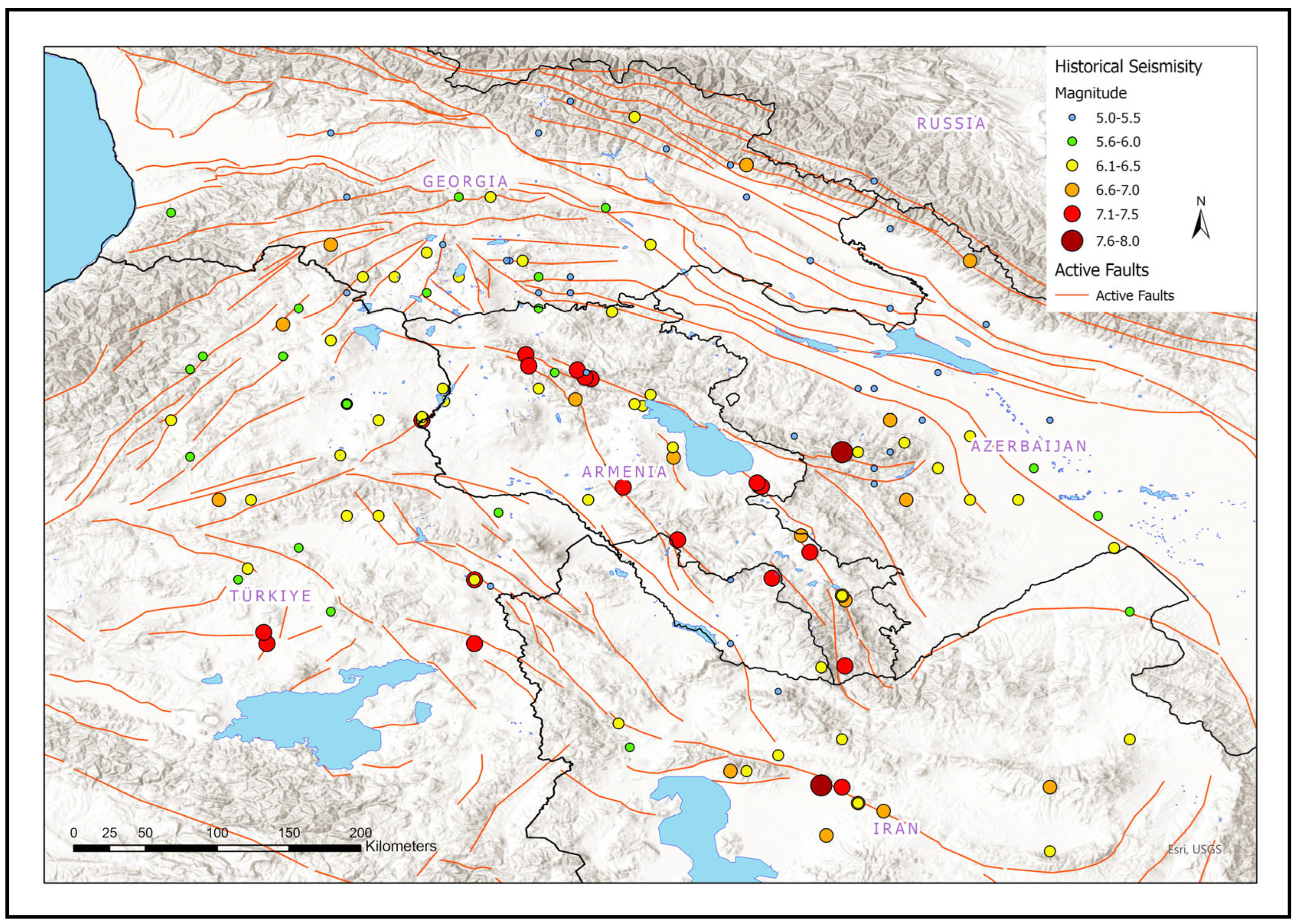
29]. These events were used to evaluate magnitude–intensity relationships, attenuation characteristics, and statistical parameters required for magnitude estimation. The spatial distribution of historical seismicity in Armenia and the surrounding region is shown in
Figure 1.
3.1.3. Instrumental Seismicity
Instrumental monitoring of seismicity in Armenia began in 1932, when the first seismic station became operational in the country. The instrumental earthquake catalog can be divided into two main periods: an early instrumental period (1932–1962) and a modern instrumental period (1962–2020). The modern period corresponds to the expansion and integration of regional seismic stations into international seismic monitoring networks.
Several strong earthquakes have occurred in the surrounding region during the instrumental period, illustrating the high seismic activity of the Arabia–Eurasia collision zone. These include the 1976 Çaldıran earthquake (Mw 7.1) and the 1983 Narman–Erzurum earthquake (Mw 7.0) in eastern Turkey, the 1988 Spitak earthquake (Mw 7.1) in Armenia, the 1990 Rudbar earthquake (Mw 7.7) in Iran, the 1991 Racha earthquake (Mw 7.1) in Georgia, the 2003 Bingöl earthquake (Mw 6.4) in eastern Turkey, and the 2011 Van earthquake (Mw 7.2) in Turkey.
In recent decades, the seismic monitoring network in Armenia has been significantly upgraded through the installation of modern broadband and high-sensitivity seismic stations. As a result, instrumental seismicity provides a more reliable representation of earthquake occurrence due to improved detection capabilities and more accurate hypocenter determination.
The Gardner and Knopoff (1974) [
30] declustering algorithm was applied using standard time and distance windows as commonly adopted in seismic hazard studies. These parameters define magnitude-dependent temporal and spatial windows for identifying dependent events and separating them from the background seismicity.
It should be noted that declustering results may be sensitive to the choice of window parameters, which can influence the estimated background seismicity rates and the relative contribution of fault-based and distributed sources. A detailed sensitivity analysis of these parameters is beyond the scope of this study; however, the adopted approach is consistent with standard practices in probabilistic seismic hazard assessment.
Although declustering introduces some degree of uncertainty, previous studies have shown that its influence on large-scale seismic hazard estimates is generally limited compared to other sources of epistemic uncertainty. In this study, the adopted approach provides a consistent and widely accepted representation of independent seismicity suitable for probabilistic analysis. A detailed sensitivity analysis of declustering parameters is beyond the scope of this study but represents a potential direction for future work.
The instrumental earthquake catalog used in this study contains 835 events recorded in Armenia and the surrounding region. The catalog covers a magnitude range from Mw 2.99 to Mw 7.14, thus including both moderate and strong earthquakes relevant to regional seismic hazard assessment. The depth distribution indicates that the seismicity is predominantly shallow: 818 of the 834 events with reported focal depths occurred at depths less than 25 km, confirming that shallow crustal earthquakes represent the main contributors to seismic hazard in the study area.
The magnitude of completeness (Mc) was estimated as Mw 4.0 using the maximum curvature method. It should be noted that Mc estimates are subject to uncertainty related to binning choices and data variability. However, the adopted value is consistent with the detection capability of the regional seismic network and with previously published studies for the Caucasus region.
The analysis indicates that the catalog is complete for magnitudes Mw ≥ 4.0 over the considered time period. This completeness threshold was adopted for the estimation of seismicity parameters, ensuring the reliability of the derived Gutenberg–Richter relationship.
Magnitudes reported in ML, Ms, and mb were converted to Mw using the empirical relationships of Scordilis [
31]. While these global relationships are widely used in seismic hazard studies, their application may introduce regional bias. In the absence of region-specific conversion relations for Armenia, this approach represents a practical and commonly accepted solution, although associated uncertainties should be considered when interpreting recurrence parameters.
Although magnitude conversion introduces additional uncertainty, this effect is partially mitigated by the use of a magnitude of completeness threshold (Mc) and by the statistical treatment of seismicity parameters within the Gutenberg–Richter framework. This approach is consistent with standard practices in probabilistic seismic hazard assessment.
Where possible, consistency checks were performed to ensure that the converted magnitudes are compatible with regional seismicity characteristics and do not introduce systematic bias in the frequency–magnitude distribution.
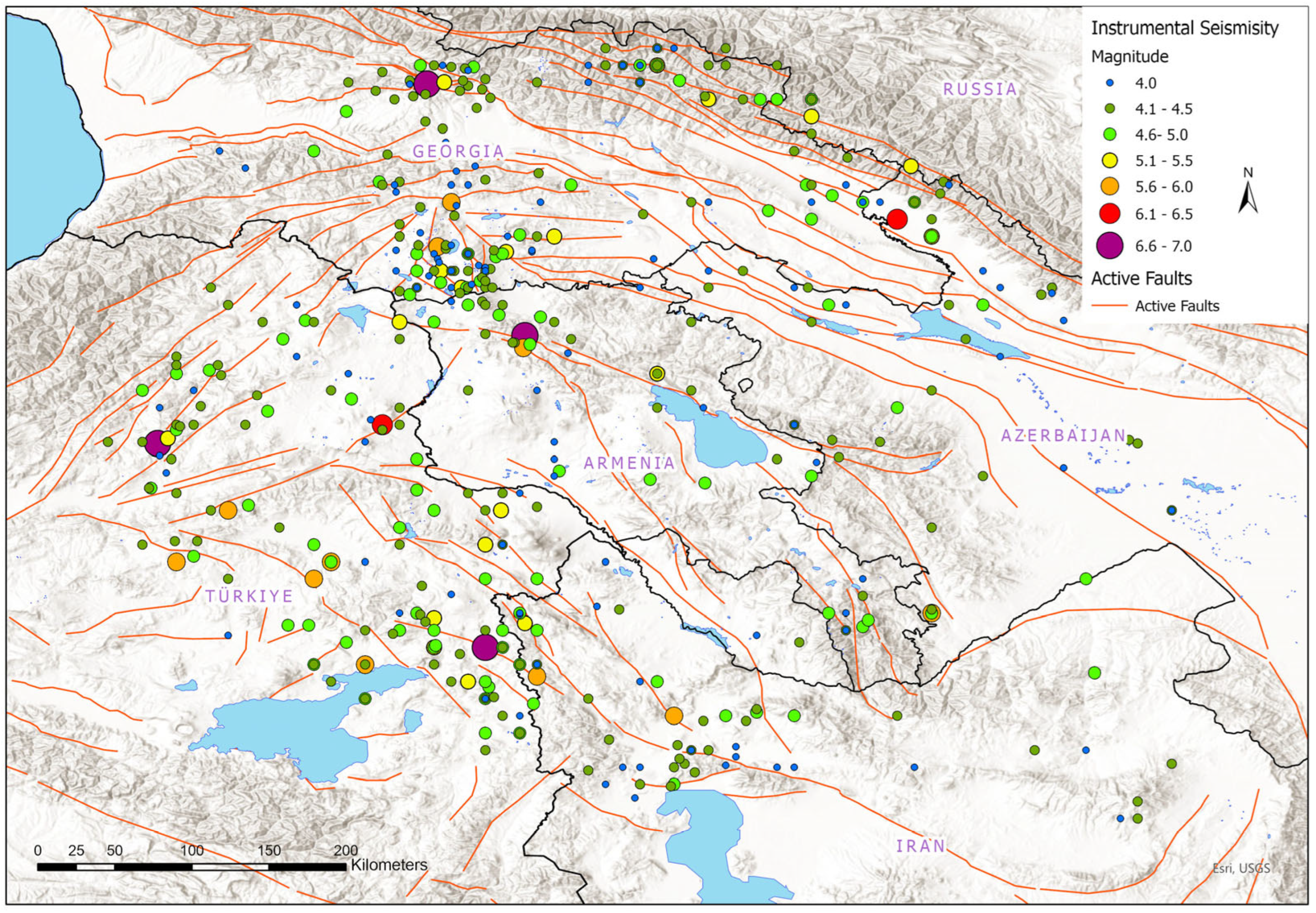
The final declustered catalog is dominated by shallow crustal earthquakes (depth < 25 km), which represent the primary contributors to seismic hazard in Armenia. Consistent with this observation,
Figure 2 indicates that most instrumental seismicity occurs at shallow depths.
In contrast to the historical seismicity shown in
Figure 1,
Figure 2 presents instrumental seismicity (1932–2020), which is characterized by a much denser distribution of smaller-magnitude earthquakes. The spatial distribution of instrumental seismicity in Armenia and the surrounding region is shown in
Figure 2.
3.2. Active Fault Database
Numerous tectonically active faults accommodate plate convergence within the Arabia–Eurasia continental collision zone. Armenia and the surrounding regions of eastern Turkey and northwestern Iran contain several major strike-slip and reverse fault systems oriented obliquely to the northward motion of the Arabian Plate. These fault systems, with individual lengths ranging from approximately 350 to 500 km and slip rates between 0.5 and 4 mm/yr, have generated numerous large earthquakes [
2,
26,
28,
32,
33,
34,
35].
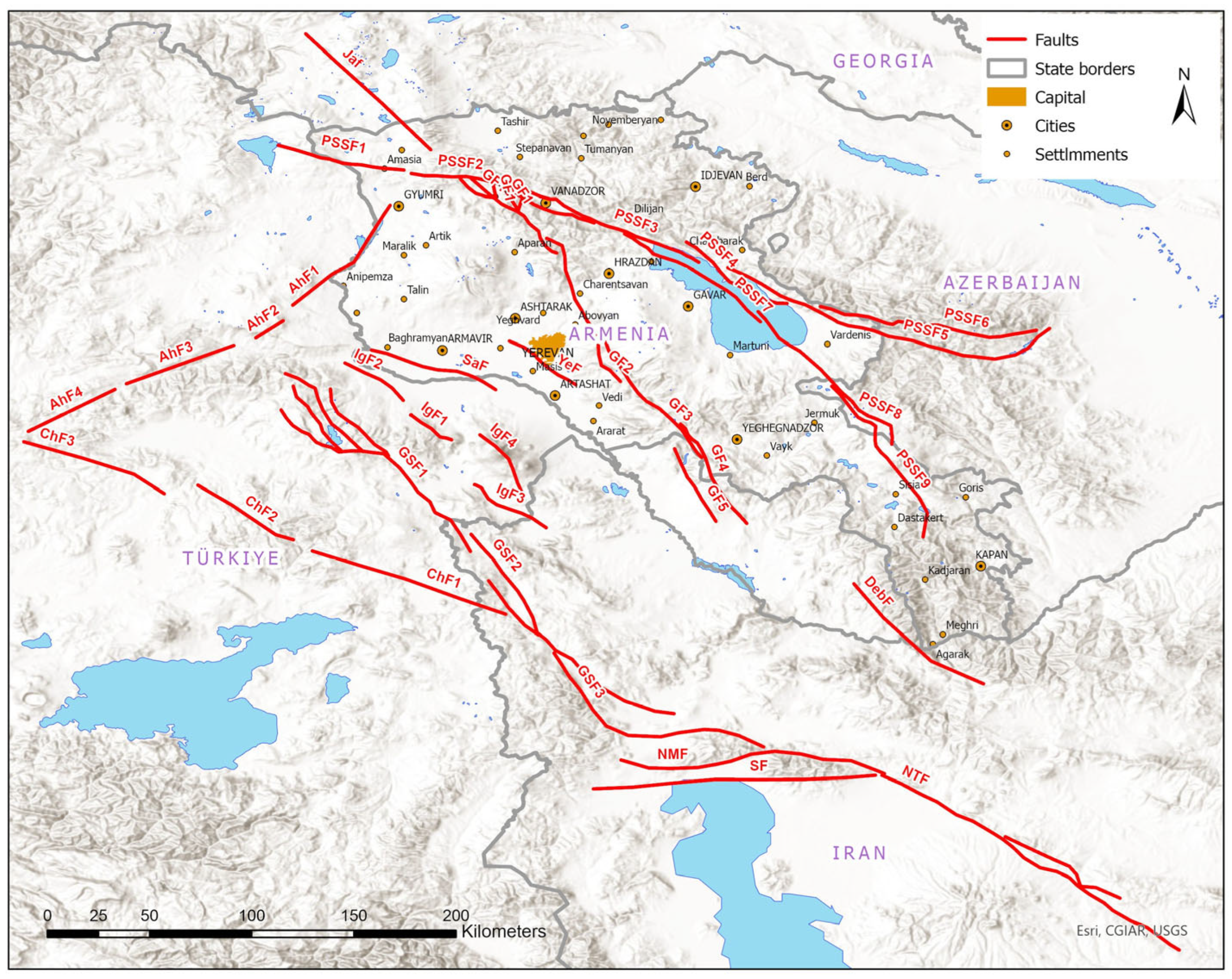
An updated active fault database was developed for this study using multiple sources of geological and geophysical information. The spatial distribution of active fault systems used in the development of the seismotectonic model is shown in
Figure 3. The fault database used in this study was compiled from published geological and seismotectonic studies of Armenia and the surrounding region.
The fault database used in this study was compiled from published geological and seismotectonic studies of Armenia and the surrounding region. Fault geometry and kinematic parameters (e.g., strike, dip, rake, and fault length) were derived primarily from previously published datasets and reports, supplemented where necessary by regional tectonic interpretations.
The selection of faults included in the model was based on their documented evidence of Quaternary activity and their relevance to regional seismic hazard. Only faults with sufficient geological or geophysical constraints were incorporated into the seismic source model.
Uncertainties in fault parameters, including fault geometry and maximum magnitude (Mmax), were accounted for through the logic-tree framework by considering alternative parameter values and model assumptions. This approach allows the propagation of epistemic uncertainty into the final hazard estimates.
The database integrates multiple sources of geological and geophysical information, including:
field geological investigations,
paleoseismological trenching studies,
remote sensing and geomorphological analysis,
previously published tectonic studies.
For each identified fault, the following parameters were compiled:
fault geometry and segmentation,
kinematic type,
total and segment lengths,
slip rates (when available),
evidence of historical or paleoseismic surface ruptures.
The maximum earthquake magnitude (Mmax) associated with each fault source was estimated using empirical scaling relationships between rupture length and earthquake magnitude proposed by Wells and Coppersmith (1994) [
21]. These relationships were selected due to their widespread use and validation in probabilistic seismic hazard studies worldwide, providing a consistent framework for estimating earthquake magnitude from fault parameters in the absence of direct observational constraints.
In cases where paleoseismological evidence indicated larger earthquake magnitudes, these values were preferentially adopted, as direct geological observations are considered to provide more reliable constraints on maximum earthquake size.
It is noted that alternative empirical relationships [
36,
37] may yield different Mmax estimates depending on regional tectonic conditions and fault characteristics. Rather than explicitly comparing individual scaling relations, this epistemic uncertainty is incorporated through the use of alternative Mmax values within the logic-tree framework.
For each fault source, a range of Mmax values was considered within the logic tree to account for uncertainty, and corresponding weights were assigned based on the reliability of available geological and seismological constraints.
Slip-rate estimates, when available, were also used to constrain long-term seismic moment release and to balance the relative contributions of fault-based and distributed seismicity sources within the hazard model.
The seismic source model implemented in this study adopts a hybrid approach that combines fault-based sources with distributed background seismicity. Fault sources represent large, characteristic earthquakes associated with mapped active faults, while background seismicity accounts for smaller-magnitude events and seismic activity not explicitly associated with identified fault structures.
To avoid double counting of seismicity, the maximum magnitude assigned to background (area) sources was constrained to remain below the characteristic magnitudes of mapped fault sources within each seismic source zone. This threshold was defined on a zone-specific basis, depending on the maximum magnitude assigned to the corresponding fault sources. In this way, large-magnitude events are exclusively attributed to fault-based sources, while background seismicity captures only the distributed component of earthquake occurrence.
The relative contribution of fault-based and background seismicity was constrained using available geological information, slip-rate estimates (where available), and observed seismicity patterns. This approach ensures a physically consistent distribution of seismic moment release between fault-controlled and distributed seismic sources within each zone (
Figure 3).
3.3. Seismic Source Model
The seismic source model developed for this study integrates both fault-based sources and distributed background seismicity in order to represent the spatial variability of earthquake occurrence within the Armenia region.
Two principal source types were considered:
Fault-based characteristic sources, representing major mapped active faults identified in the active fault database. These sources correspond to well-defined tectonic structures capable of generating large earthquakes and are characterized by parameters such as fault geometry, segmentation, slip rate, and maximum expected magnitude.
Area-source Gutenberg–Richter (GR) seismicity, representing distributed background deformation not explicitly associated with mapped faults. These area sources account for smaller earthquakes and diffuse seismicity occurring within broader seismotectonic zones.
The combination of fault-based and area-source models allows the hazard analysis to incorporate both large characteristic earthquakes occurring on major faults and more diffuse seismicity distributed across the regional crust.
For each seismic source zone, earthquake recurrence was modeled using the Gutenberg–Richter frequency–magnitude relationship, with parameters estimated from the declustered earthquake catalog using the maximum-likelihood method of Weichert [
38]. This approach provides a statistically consistent representation of earthquake occurrence rates for probabilistic seismic hazard calculations.
3.3.1. Shallow Crustal Seismicity
A total of 26 shallow crustal seismic source zones (depth range 0–25 km) were defined based on regional tectonic boundaries, spatial clustering of seismicity, and the distribution of mapped active faults.
For each seismic source zone, the Gutenberg–Richter recurrence parameters (a- and b-values) were estimated using the Weichert [
38] maximum-likelihood method, which accounts for variations in catalog completeness through time.
Upper-bound magnitudes for each area source zone were constrained to remain below the characteristic magnitudes assigned to mapped fault sources within the same zone. This constraint was introduced to prevent double counting of large-magnitude events, which are explicitly represented by fault-based characteristic sources in the model. Consequently, the area-source component captures only the distributed background seismicity, while large earthquakes are exclusively associated with individual fault sources.
The magnitude–frequency distribution in each zone was represented using a hybrid seismicity model, consisting of:
a truncated Gutenberg–Richter distribution describing distributed background seismicity, and
characteristic magnitude distributions assigned to major mapped fault sources.
This combined approach allows both distributed crustal deformation and fault-controlled earthquake occurrence to be represented within the probabilistic seismic hazard framework.
3.3.2. Deeper Seismicity
Seismicity occurring at depths greater than 25 km was modeled using a smoothed gridded seismicity approach, which represents distributed earthquake occurrence within deeper crustal and upper mantle layers.
For these deeper seismic sources, earthquake occurrence rates were estimated from the declustered earthquake catalog and spatially distributed across a regular grid covering the study region. The magnitude–frequency relationships for these sources follow the Gutenberg–Richter recurrence model, with parameters calibrated using regional seismicity data.
This representation accounts for earthquakes not directly associated with mapped shallow crustal faults and allows deeper seismic events to be incorporated into the probabilistic seismic hazard model.
3.4. Ground Motion Modeling
Ground motion was modeled using a logic-tree framework in order to account for epistemic uncertainties in both seismic source characterization and ground-motion prediction.
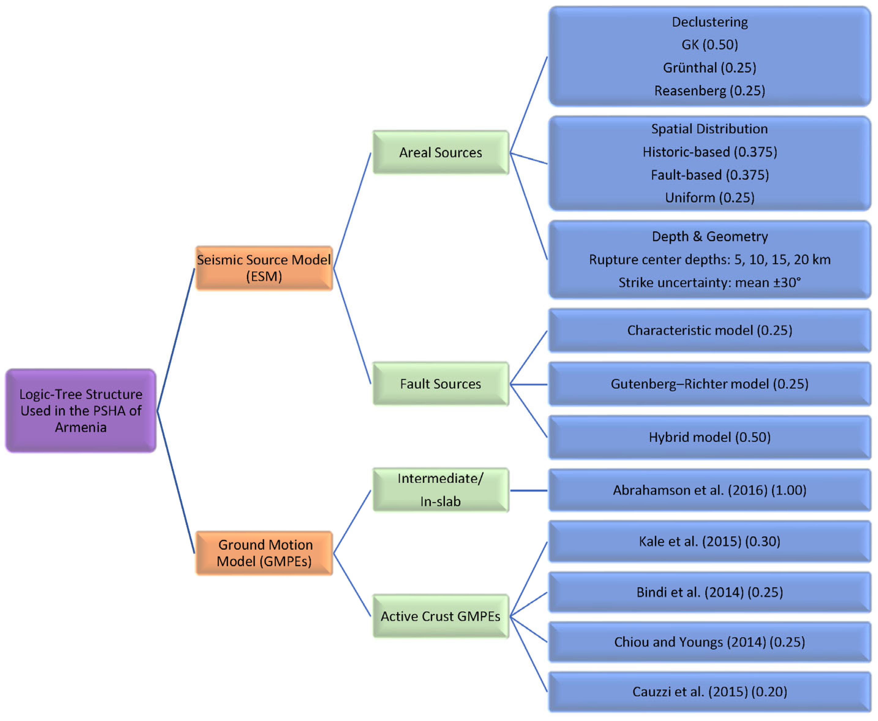
The overall logic-tree structure adopted in this study is illustrated in
Figure 4. The framework incorporates epistemic uncertainties associated with both seismic source characterization and ground-motion prediction.
On the seismic source side, the logic tree distinguishes between areal (background) seismicity and fault-based sources. For areal sources, alternative representations of declustering methods, spatial distribution models, and source geometry parameters are considered. For fault sources, different earthquake recurrence models are implemented, including characteristic, Gutenberg–Richter, and hybrid models. On the ground-motion side, epistemic uncertainty is represented through the use of multiple ground-motion prediction equations (GMPEs) for shallow crustal earthquakes, with assigned weights reflecting their applicability to active continental tectonic environments.
A separate GMPE is used for intermediate-depth (in-slab) seismicity. The combination of these branches allows the propagation of epistemic uncertainty through the hazard calculations, resulting in mean hazard estimates and associated percentile ranges derived from the full logic-tree ensemble.
The logic-tree framework includes alternative models representing different assumptions regarding (i) seismic source parameters (e.g., maximum magnitude, recurrence parameters, and fault segmentation) and (ii) ground-motion prediction equations (GMPEs). For shallow crustal earthquakes, four GMPEs were included with assigned weights reflecting their applicability to active continental tectonic environments and their performance in previous regional studies.
For seismic source characterization, alternative parameter sets were considered to reflect uncertainties in fault geometry, maximum magnitude (Mmax), and earthquake recurrence behavior. The weights assigned to each branch were selected based on expert judgment and consistency with previous regional seismic hazard assessments, ensuring a balanced representation of epistemic uncertainty.
Earthquakes occurring at intermediate depths were modeled using a separate GMPE appropriate for in-slab and intermediate-depth seismicity, ensuring that differences in attenuation behavior and source characteristics were properly represented.
This framework produces multiple hazard realizations corresponding to different plausible model assumptions. Final hazard estimates are obtained as mean values and percentile distributions derived from the full ensemble of logic-tree branches.
Recent studies have also proposed updated ground-motion models and region-specific calibrations that further improve hazard estimation in active tectonic regions [
11,
39].
Ground-Motion Models Used in the Logic-Tree Framework
Ground motions for shallow crustal earthquakes were estimated using a weighted set of ground-motion prediction equations (GMPEs) applicable to active continental tectonic environments. The adopted models include:
Cauzzi et al. (2015) [
41]
Chiou and Youngs (2014) [
42]
These models were selected based on their applicability to the tectonic setting of the Caucasus region and their performance in previous regional seismic hazard assessments.
Within the logic-tree framework, the following weights were assigned to the GMPE branches:
Kale et al. (2015) [
43]—0.30
Bindi et al. (2014) [
40]—0.25
Chiou and Youngs (2014) [
42]—0.25
Cauzzi et al. (2015) [
41]—0.20
The weights were assigned considering the applicability of these models to active continental tectonic environments and their performance in previous regional seismic hazard assessments.
For intermediate-depth seismicity, the Abrahamson et al. (2016) [
44] ground-motion model was applied. The selected GMPE set is consistent with the ground-motion model adopted in the SHARA17 probabilistic seismic hazard assessment for Armenia.
This approach ensures a balanced representation of epistemic uncertainty in ground-motion prediction. In addition, the selected GMPEs were evaluated for their compatibility with regional tectonic conditions and available ground-motion datasets, ensuring their suitability for application in the Armenia region.
3.5. Hazard Computation
Probabilistic seismic hazard calculations were performed using the OpenQuake engine, developed by the Global Earthquake Model (GEM) Foundation. The OpenQuake engine was selected because it provides:
open-source architecture,
capability to implement complex logic-tree frameworks,
support for hazard deaggregation analysis, and
flexibility in modeling both fault-based and area seismic sources.
Seismic hazard was computed for several return periods, with particular emphasis on the 475-year return period, corresponding to a 10% probability of exceedance in 50 years, which is commonly used for structural design in seismic building codes.
Hazard calculations were performed assuming reference site conditions of Vs30 = 500 m/s, consistent with previous seismic zonation studies in Armenia. Additional calculations were carried out for Vs30 = 800 m/s in order to evaluate the influence of site conditions on ground-motion estimates.
4. Results
4.1. Probabilistic Seismic Hazard Maps
Probabilistic seismic hazard was computed for several return periods. In this section, the analysis focuses primarily on the 475-year return period, corresponding to a 10% probability of exceedance in 50 years, which is commonly adopted for seismic design applications.
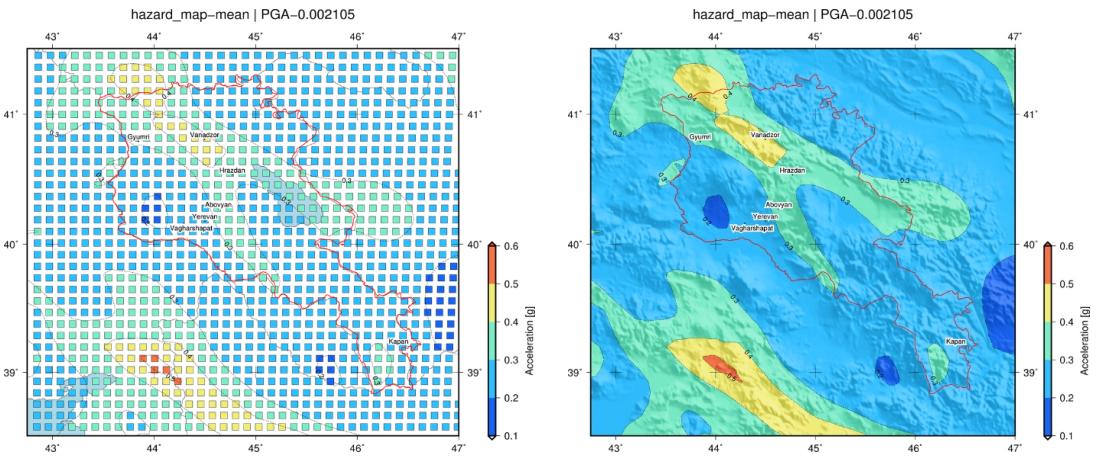
For reference site conditions of Vs30 = 500 m/s, peak ground acceleration (PGA) values across Armenia range from approximately 0.2 g to 0.5 g (
Figure 5).
The spatial distribution of seismic hazard reveals a clear tectonic control across Armenia. The highest hazard levels (0.4–0.5 g) are concentrated in northwestern Armenia, particularly near Vanadzor, where major segments of the Pambak–Sevan–Syunik Fault System (PSSF) are located. Elevated hazard levels (0.3–0.4 g) extend along the PSSF and Garni Fault corridors, affecting major population centers such as Gyumri, Hrazdan, and Abovyan. Yerevan, the capital city, is characterized by hazard levels generally ranging from 0.2 to 0.3 g, locally approaching 0.3 g in areas influenced by the Garni Fault. In contrast, lower hazard values are observed in southwestern Armenia and in limited areas of the western part of the country.
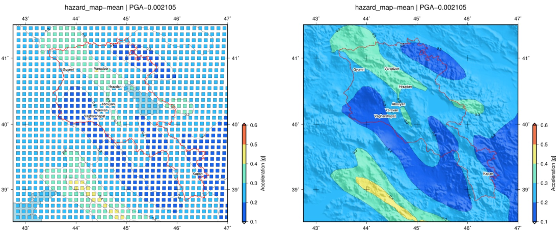
When hazard calculations are performed for Vs30 = 800 m/s, PGA values decrease systematically; however, the overall spatial pattern remains essentially unchanged, confirming that regional tectonic structure and seismic source distribution, rather than local site conditions, primarily control the large-scale hazard pattern (
Figure 6).
The elongated geometry of high-hazard zones trending NNW–SSE closely follows the orientation of major strike-slip fault systems, highlighting the dominant role of regional tectonics in controlling the distribution of seismic hazard.
4.2. Hazard Curves for Selected Major Cities
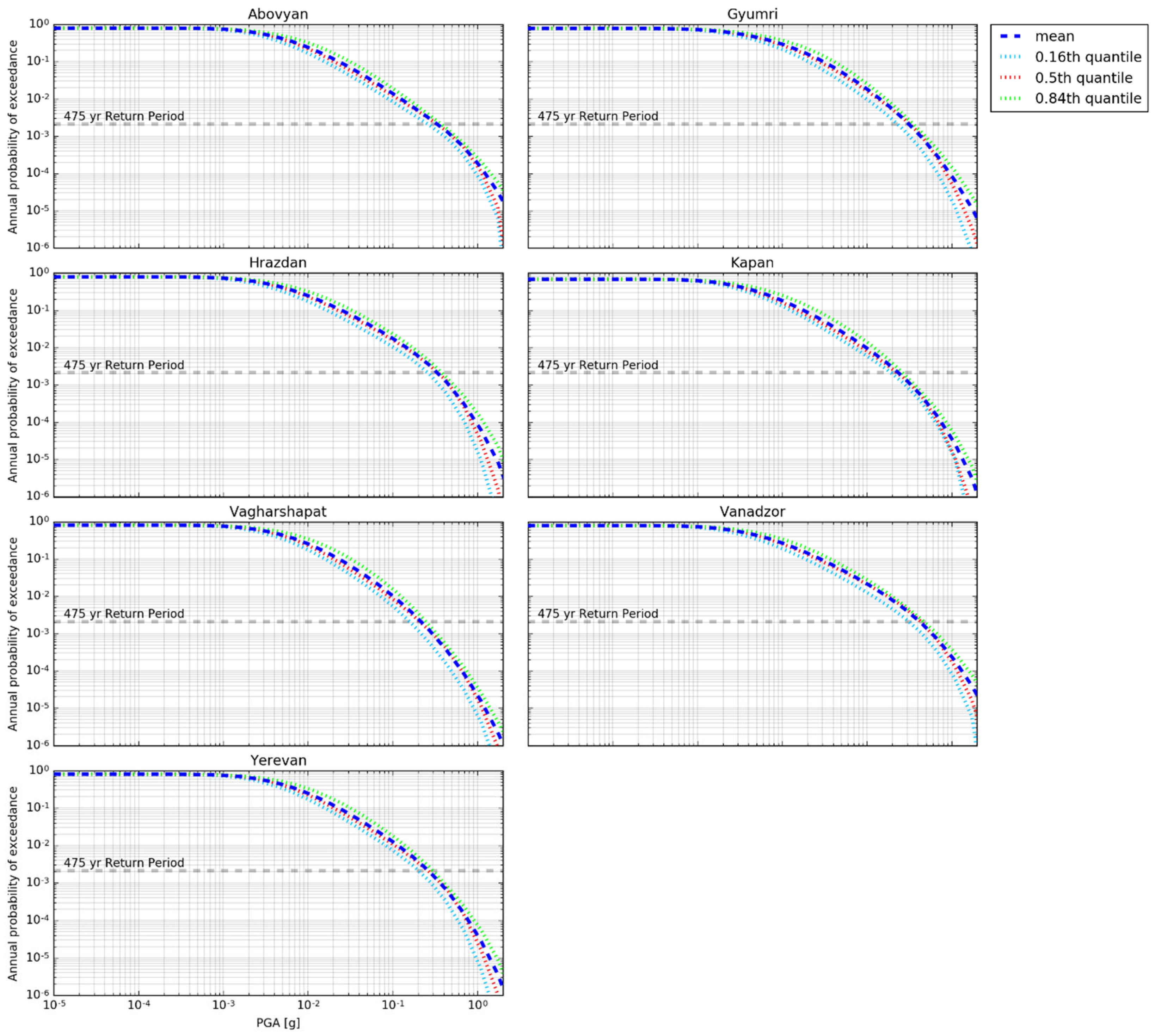
Hazard curves were generated for several major urban centers in Armenia, including Abovyan, Gyumri, Hrazdan, Kapan, Vagharshapat, Vanadzor, and Yerevan, as shown in
Figure 7.
The hazard curves presented in
Figure 7 were computed using the OpenQuake engine by extracting site-specific hazard results at the locations of the selected cities. For each site, the annual probability of exceedance was calculated over a range of peak ground acceleration (PGA) values, based on the full logic-tree ensemble of seismic source models and ground-motion prediction equations.
The resulting hazard curves represent mean estimates as well as percentile distributions (e.g., 16th, 50th, and 84th percentiles), reflecting the epistemic uncertainty incorporated in the PSHA framework.
The mean hazard curves derived from the logic-tree ensemble indicate distinct variations in seismic hazard among the selected cities. Vanadzor exhibits the highest exceedance probabilities for design-level ground motions, reflecting its proximity to major segments of the Pambak–Sevan–Syunik Fault System. Gyumri similarly exhibits elevated hazard levels, consistent with its location within tectonically active zones of northwestern Armenia. Yerevan displays moderate but still significant hazard levels, with ground-motion exceedance probabilities influenced by nearby active structures, particularly the Garni Fault.
The uncertainty range, represented by the 16th and 84th percentile hazard curves, reflects epistemic uncertainty associated with both seismic source characterization and ground-motion prediction models. Nevertheless, the uncertainty bounds remain within the range typically observed for active continental tectonic regions [
45,
46].
4.3. Deaggregation Analysis
To better understand the earthquake scenarios controlling seismic hazard, hazard deaggregation was performed for selected major cities at the 475-year return period. The deaggregation analysis was carried out in terms of magnitude, source-to-site distance, and epsilon (M–R–ε), allowing identification of the earthquake scenarios that contribute most to the design-level ground motions.
The results indicate that the design-level seismic hazard is predominantly controlled by:
earthquakes with magnitudes between Mw 6.8 and 7.4,
source-to-site distances generally less than 30 km, and
shallow crustal events (depth < 25 km).
For Yerevan, the primary hazard contribution is associated with potential rupture of the Garni Fault and nearby tectonic structures. In contrast, the hazard for Vanadzor and Gyumri is dominated by earthquakes occurring along major segments of the Pambak–Sevan–Syunik Fault System (PSSF).
These results demonstrate that near-field earthquakes occurring on local active faults, rather than distant large-magnitude events, represent the principal contributors to design-level seismic hazard in Armenia.
4.4. Comparison with Previous Seismic Zonation
The updated seismic hazard model shows general consistency with previous national seismic hazard assessments while providing improved spatial resolution and a more detailed representation of high-hazard zones.
The results indicate that seismic hazard in Armenia is strongly controlled by regional tectonic structure, with the highest hazard levels concentrated in northwestern Armenia. A detailed comparison with regional and international seismic hazard models is provided in
Section 5.2.
5. Discussion
5.1. Structural Control of Seismic Hazard
The spatial distribution of seismic hazard obtained in this study shows a strong correlation with the active tectonic framework of Armenia. The highest peak ground acceleration (PGA) values are concentrated along the Pambak–Sevan–Syunik Fault System (PSSF) and the Garni Fault, confirming that major strike-slip fault systems exert a dominant control on seismic hazard in the region.
The elongation of high-hazard zones in an NNW–SSE direction closely follows the geometry of these fault systems and reflects the pattern of strain partitioning within the Arabia–Eurasia collision zone. This structural control indicates that long-term strain accumulation along major strike-slip corridors represents the primary driver of seismic hazard in Armenia.
The concentration of elevated hazard levels in northwestern Armenia, particularly in the vicinity of Vanadzor, is consistent with both paleoseismological evidence of large-magnitude earthquakes and historical earthquake records. This agreement suggests that the proposed hazard model successfully captures the regional tectonic loading pattern and provides a realistic representation of the dominant seismic sources in the country.
5.2. Comparison with Regional Hazard Models
This section provides a detailed comparison of the obtained seismic hazard results with previous national and regional hazard models. The seismic hazard model developed in this study is broadly consistent with previous regional assessments, including the Global Seismic Hazard Assessment Program (GSHAP) [
6] and the European–Mediterranean Seismic Hazard Model (EMME14) [
7].
The obtained hazard levels are also broadly consistent with the results of the European Seismic Hazard Model 2020 (ESHM20), which represents one of the most recent large-scale seismic hazard assessments for Europe. Although Armenia is located near the eastern boundary of the ESHM20 model domain, the regional hazard patterns and PGA levels predicted by our model are generally comparable to those obtained from the European model.
In addition, previous continental-scale projects such as the SHARE (Seismic Hazard Harmonization in Europe) initiative also indicate elevated seismic hazard levels in the Caucasus region associated with the Arabia–Eurasia collision zone. These comparisons further support the robustness of the hazard estimates obtained in this study, as the estimated PGA levels are also consistent with observed ground-motion characteristics from past strong earthquakes in the region.
Similar hazard levels were also obtained in the SHARA17 probabilistic seismic hazard model developed for Armenia and its surrounding regions, which estimated mean PGA values between approximately 0.16 g and 0.40 g for a 10% probability of exceedance in 50 years at reference rock conditions (Vs30 = 800 m/s).
However, several important methodological improvements are introduced in the present model:
Higher spatial resolution, resulting from detailed parameterization of local active fault systems.
Improved constraints on maximum earthquake magnitude (Mmax) based on updated paleoseismological data.
Implementation of a hybrid seismicity model, combining characteristic earthquake sources associated with mapped faults and distributed background seismicity.
Use of a logic-tree framework that systematically incorporates epistemic uncertainty in both seismic source characterization and ground-motion prediction.
While the EMME14 model relied partly on large regional area-source representations, the present study places greater emphasis on Armenia-specific geological and tectonic information. As a result, hazard gradients near major active fault systems are more clearly defined.
Despite these methodological differences, the peak ground acceleration (PGA) values estimated for the 475-year return period remain broadly consistent with those obtained in previously published regional hazard models.
Overall, the comparison confirms that the proposed model is consistent with previous regional assessments, while offering improved spatial resolution, refined source characterization, and a more explicit representation of fault-controlled seismic hazard in Armenia. The consistency of the obtained PGA values with previously published regional hazard models (e.g., GSHAP, EMME14, ESHM20, and SHARA17) further supports the reliability of the results.
These comparisons not only demonstrate consistency in overall hazard levels, but also confirm that the spatial distribution of seismic hazard identified in this study is in agreement with patterns reported in previous regional and international studies [
9,
12]. In particular, the concentration of higher hazard levels in northwestern Armenia and along major strike-slip fault systems is consistent with findings from recent seismic hazard assessments in tectonically similar regions.
Such agreement provides additional support for the robustness of the adopted methodology and indicates that the integration of geological, seismotectonic, and seismological datasets leads to physically consistent and reliable hazard estimates.
It is acknowledged that alternative empirical relationships and ground-motion models have been proposed in recent studies, which may yield different estimates of seismic hazard depending on their underlying assumptions and regional calibration. The use of alternative magnitude scaling relations or ground-motion prediction equations could potentially affect the estimated hazard levels, particularly in terms of absolute PGA values.
However, previous studies have shown that while different model choices may influence the numerical values of hazard estimates, the overall spatial patterns of seismic hazard are generally robust, especially when constrained by geological and seismotectonic information. Therefore, the main conclusions of this study, including the identification of high-hazard regions and the relative ranking of seismic hazard across Armenia, are expected to remain stable under alternative model assumptions.
Although a formal statistical sensitivity analysis was not performed, the robustness of the results can be qualitatively assessed within the adopted logic-tree framework. Variations in key input parameters, such as seismic source characterization, magnitude scaling relations, ground-motion prediction equations, and site conditions (e.g., Vs30), are represented within the logic-tree structure. As a result, the mean hazard values and associated percentile ranges provide an implicit measure of sensitivity to model assumptions.
A systematic evaluation of alternative models represents an important direction for future work and would further enhance the robustness of seismic hazard assessments in the region.
5.3. Dominant Earthquake Scenarios
Hazard deaggregation results indicate that seismic hazard in major Armenian cities is predominantly controlled by shallow crustal earthquakes with magnitudes between Mw 6.8 and 7.4, occurring within approximately 30 km of the site.
These findings have several important implications:
Local large-magnitude earthquakes represent the principal seismic threat to major urban areas.
Distant earthquakes contribute relatively little to the design-level seismic hazard.
Fault segmentation and rupture characteristics play a critical role in controlling hazard estimates.
For Yerevan, the Garni Fault represents the primary controlling seismic source. In contrast, the seismic hazard in Vanadzor and Gyumri is mainly influenced by earthquakes occurring along major segments of the Pambak–Sevan–Syunik Fault System (PSSF).
These observations are consistent with both the historical distribution of earthquakes and the regional tectonic framework, reinforcing the importance of incorporating detailed fault-based information into probabilistic seismic hazard assessments.
5.4. Uncertainty and Model Robustness
The logic-tree framework adopted in this study allows epistemic uncertainty to be explicitly incorporated into the seismic hazard calculations. The principal sources of uncertainty include:
seismic source geometry and fault segmentation,
magnitude–frequency relationships, and
the selection and weighting of ground-motion prediction equations (GMPEs).
The resulting spread between percentile hazard estimates remains moderate, suggesting that the overall spatial pattern of seismic hazard is relatively stable across different model assumptions.
Uncertainty is greatest in areas located near major active fault systems, where variations in rupture segmentation, slip-rate estimates, and maximum magnitude constraints (Mmax) may significantly influence hazard estimates.
Future advances in paleoseismological investigations, geodetic measurements, and seismic monitoring networks will help reduce these uncertainties and further refine probabilistic seismic hazard assessments in Armenia.
5.5. Implications for Seismic Zonation and Risk Reduction
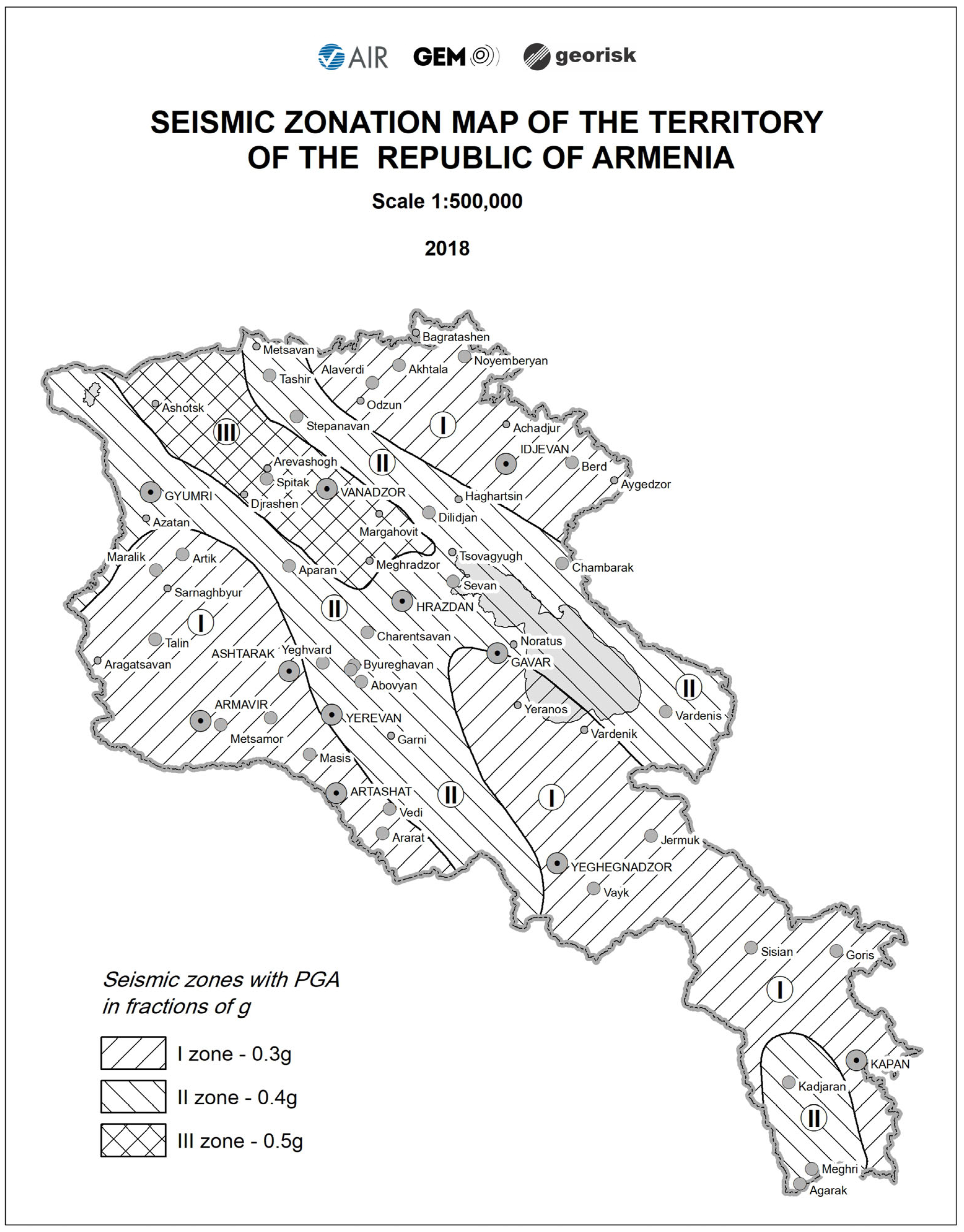
The updated hazard results provide a robust scientific basis for seismic zonation in Armenia. The identification of peak ground acceleration (PGA) values reaching 0.4–0.5 g in northwestern Armenia supports the adoption of enhanced seismic design requirements for infrastructure located in this region (
Figure 8).
The seismic zonation map shown in
Figure 8 is directly derived from the PSHA results obtained in this study. Specifically, the map is based on the spatial distribution of peak ground acceleration (PGA) values for a 475-year return period, which were used to define discrete seismic hazard zones in accordance with national seismic design requirements.
Based on the probabilistic hazard results, the territory of Armenia can be divided into three principal seismic zones (
Table 1).
These zones form the basis for the national seismic building code and provide guidance for seismic design and risk mitigation measures across the country.
The agreement between the PSHA-derived PGA values and the proposed seismic zonation used for the national building code further supports the practical applicability and consistency of the results.
Overall, the results of this study represent a comprehensive and integrative effort toward the development of an updated probabilistic seismic hazard model for Armenia. By combining geological, seismotectonic, and seismological datasets within a unified logic-tree framework, this work provides an improved and internally consistent basis for seismic hazard assessment in the region.
Compared to previous studies, the present model incorporates updated datasets, refined source characterization, and a transparent treatment of epistemic uncertainties. These advancements contribute to a more reliable and robust seismic hazard evaluation, which is essential for seismic risk mitigation, engineering applications, and future seismic zonation of Armenia.
6. Conclusions
This study presents an updated probabilistic seismic hazard assessment (PSHA) for the Republic of Armenia based on an integrated seismotectonic framework that incorporates active fault data, historical and instrumental seismicity, and modern ground-motion prediction models within a logic-tree approach.
The results indicate that seismic hazard in Armenia is strongly controlled by major strike-slip fault systems, particularly the Pambak–Sevan–Syunik Fault System and the Garni Fault. For a 475-year return period, peak ground acceleration (PGA) values across the country range from approximately 0.2 g to 0.5 g.
The highest hazard levels are concentrated in northwestern Armenia, particularly in the vicinity of Vanadzor, whereas central regions, including Yerevan, exhibit moderate hazard levels. Although the hazard level in Yerevan is lower than in northwestern Armenia, the city remains vulnerable due to its large population, economic importance, and proximity to active fault systems.
Hazard deaggregation analysis demonstrates that seismic hazard in major Armenian cities is primarily controlled by shallow crustal earthquakes with magnitudes between Mw 6.8 and 7.4, occurring at source-to-site distances generally less than 30 km. These findings emphasize the dominant role of local active faults in controlling design-level ground motions.
Compared with earlier national and regional hazard assessments, the present model provides improved spatial resolution, updated constraints on maximum earthquake magnitude (Mmax), and a more explicit treatment of epistemic uncertainty through the use of a logic-tree framework. The resulting hazard maps therefore provide a scientifically robust basis for seismic zonation and for the development of Armenia’s national seismic building code.
Given the ongoing convergence between the Arabian and Eurasian plates and the associated accumulation of tectonic strain, significant seismic hazard is expected to persist in the region. Continued improvements in active fault characterization, seismic monitoring, geodetic observations, and urban microzonation studies will further enhance future seismic hazard and risk assessments in Armenia.
Overall, this study represents a significant step toward the development of a modern seismic hazard framework for Armenia. The integration of multiple datasets and methodologies enhances the robustness of the results and provides a foundation for future updates of national seismic hazard maps and building codes.
Author Contributions
Conceptualization, M.G., A.K. and L.S.; methodology, M.G., A.K., A.A. and H.B.; formal analysis, M.G., A.A., E.S. and L.S.; investigation, A.K., M.G. and L.S.; resources, A.K., S.A. and G.B.; data curation, M.G., E.S. and L.S.; writing—original draft preparation, M.G., L.S. and E.S.; writing—review and editing, M.G., L.S. and E.S.; visualization, M.G., L.S., S.A. and G.B.; supervision, M.G.; project administration, H.B. and S.A. All authors have read and agreed to the published version of the manuscript.
Funding
This research was supported by the World Bank, grant number 7179350.
Data Availability Statement
The raw data supporting the conclusions of this article will be made available by the authors on request.
Acknowledgments
The probabilistic seismic hazard assessment presented in this study builds upon long-term collaborative work conducted under the coordination of the Armenian National Survey for Seismic Protection (NSSP). The authors acknowledge the role of NSSP in providing seismic data, technical infrastructure, and support for seismic hazard modeling. We also acknowledge the contributions of researchers involved in active fault investigations, paleoseismological studies, and the development of seismic monitoring networks in Armenia, whose work provided essential input data for this study. The OpenQuake engine, developed by the Global Earthquake Model (GEM) Foundation, was used for probabilistic seismic hazard calculations. Seismic data used in this study were obtained from national seismic monitoring networks and affiliated research institutions in Armenia. During the preparation of this manuscript, the authors used AI tools for language polishing and improving the clarity of the manuscript. The authors have reviewed and edited the output and take full responsibility for the content of this publication.
Conflicts of Interest
Authors Mikayel Gevorgyan, Arkadi Karakhanyan, Suren Arakelyan, Hektor Babayan, Gevorg Babayan, Elya Sahakyan and Lilit Sargsyan were employed by ”GEORISK” Scientific Research Company. The remaining author declares that the research was conducted in the absence of any commercial or financial relationships that could be construed as a potential conflict of interest.
References
- Dewey, J.F.; Hempton, M.R.; Kidd, W.S.F.; Şaroğlu, F.; Şengör, A.M.C. Shortening of continental lithosphere: The neotectonics of eastern Anatolia—A young collision zone. Geol. Soc. Am. Spec. Pap. 1986, 201, 3–36. [Google Scholar] [CrossRef] [Scilit]
- Philip, H.; Avagyan, A.; Karakhanian, A.; Ritz, J.F.; Rebai, S. Estimating slip rates and recurrence intervals for strong earthquakes along an intracontinental fault: Example of the Pambak–Sevan–Sunik fault (Armenia). Tectonophysics 2001, 343, 205–232. [Google Scholar] [CrossRef] [Scilit]
- Reilinger, R.; McClusky, S.; Vernant, P.; Lawrence, S.; Ergintav, S.; Çakmak, R.; Özener, H.; Kadirov, F.; Guliyev, I.; Stepanyan, R.; et al. GPS constraints on continental deformation in the Africa–Arabia–Eurasia collision zone and implications for plate dynamics. J. Geophys. Res. 2006, 111, B05411. [Google Scholar] [CrossRef] [Scilit]
- Karakhanyan, A.; Avagyan, A.; Philip, H. Active faulting and paleoseismology in Armenia: Implications for seismic hazard assessment. Ann. Geophys. 2016, 59, S0543. [Google Scholar]
- Balassanian, S.; Ashirov, T.; Karakhanyan, A.; Avagyan, A.; Nazaretyan, S. Seismic hazard assessment for Armenia. In Proceedings of the International Conference on Earthquake Hazard and Seismic Risk Reduction, Yerevan, Armenia, 14–21 September, 1998. [Google Scholar]
- Giardini, D. The global seismic hazard assessment program (GSHAP)—1992–1999. Ann. Geophys. 1999, 42, 957–974. [Google Scholar] [CrossRef] [Scilit]
- Danciu, L.; Şeşetyan, K.; Demircioglu, M.B.; Gülen, L.; Zare, M.; Basili, R.; Elias, A.; Adamia, S.; Tsereteli, N.; Yalçın, H.; et al. The 2014 earthquake model of the Middle East: Seismogenic sources. Bull. Earthq. Eng. 2018, 16, 3465–3496. [Google Scholar] [CrossRef] [Scilit]
- Shen-Tu, B.; Klein, E.; Mahdyiar, M.; Karakhanyan, A.; Pagani, M.; Weatherill, G.; Gee, R. Seismic hazard analysis for Armenia and its surrounding areas. In Proceedings of the 16th European Conference on Earthquake Engineering, Thessaloniki, Greece, 18–21 June 2018. [Google Scholar]
- Alavi, S.H.; Bahrami, A.; Mashayekhi, M.; Zolfaghari, M. Optimizing interpolation methods and point distances for accurate earthquake hazard mapping. Buildings 2024, 14, 1823. [Google Scholar] [CrossRef] [Scilit]
- Jena, R.; Pradhan, B.; Almazroui, M.; Assiri, M.; Park, H.-J. Earthquake-induced liquefaction hazard mapping at national scale in Australia using deep learning techniques. Geosci. Front. 2023, 14, 101460. [Google Scholar] [CrossRef] [Scilit]
- Allen, T.I.; Ghasemi, H.; Griffin, J.D. Exploring Australian hazard map exceedance using an atlas of historical ShakeMaps. Earthq. Spectra 2023, 39, 985–1006. [Google Scholar] [CrossRef] [Scilit]
- Schneider, M.; Cotton, F.; Schweizer, P.-J. Criteria-based visualization design for hazard maps. Nat. Hazards Earth Syst. Sci. 2023, 23, 2505–2521. [Google Scholar] [CrossRef] [Scilit]
- Shen, Y.; El Naggar, M.H.; Zhang, D.; Huang, Z.; Du, X. Optimal intensity measure for seismic performance assessment of shield tunnels in liquefiable and non-liquefiable soils. Undergr. Space 2025, 21, 149–163. [Google Scholar] [CrossRef] [Scilit]
- Shen, Y.; El Naggar, M.H.; Zhang, D.-M.; Huang, Z.-K.; Du, X. Scalar- and vector-valued seismic fragility assessment of segmental shield tunnel lining in liquefiable soil deposits. Tunn. Undergr. Space Technol. 2025, 155, 106171. [Google Scholar] [CrossRef] [Scilit]
- Vernant, P.; Nilforoushan, F.; Hatzfeld, D.; Abbassi, M.R.; Vigny, C.; Masson, F.; Nankali, H.; Martinod, J.; Ashtiani, A.; Bayer, R.; et al. Present-day crustal deformation and plate kinematics in the Middle East constrained by GPS measurements. Geophys. J. Int. 2004, 157, 381–398. [Google Scholar] [CrossRef] [Scilit]
- Ritz, J.-F.; Avagyan, A.; Mkrtchyan, M.; Nazari, H.; Blard, P.-H.; Karakhanyan, A.; Philip, H.; Balescu, S.; Mahan, S.; Huot, S.; et al. Active tectonics within the NW and SE extensions of the Pambak–Sevan–Syunik fault. Quat. Int. 2015, 395, 61–78. [Google Scholar] [CrossRef] [Scilit]
- Philip, H.; Rogozhin, E.; Cisternas, A.; Bousquet, J.C.; Borisov, A.; Karakhanian, A.S. The Armenian earthquake of 7 December 1988: Faulting and folding, neotectonics and paleoseismicity. Geophys. J. Int. 1992, 110, 141–158. [Google Scholar]
- Avagyan, A.; Ritz, J.-F.; Karakhanian, A.; Philip, H. Dual near-surface rupturing mechanism during the 1988 Spitak earthquake (Armenia). Izv. Natl. Acad. Sci. Armen. Earth Sci. 2003, 56, 14–19. [Google Scholar]
- Karakhanian, A.; Trifonov, V.; Philip, H.; Avagyan, A.; Hessami, K.; Jamali, F.; Bayraktutan, M.S.; Bagdassarian, H.; Arakelian, S.; Davtian, V.; et al. Active faulting and natural hazards in Armenia, eastern Turkey, and northwestern Iran. Tectonophysics 2004, 380, 189–219. [Google Scholar] [CrossRef] [Scilit]
- Davtyan, V. Active Faults of Armenia: Slip Rate Estimation by GPS, Paleoseismological and Morphostructural Data. Ph.D. Thesis, University of Montpellier II, Montpellier, France, 2007. [Google Scholar]
- Wells, D.L.; Coppersmith, K.J. New empirical relationships among magnitude, rupture length, rupture width, rupture area, and surface displacement. Bull. Seismol. Soc. Am. 1994, 84, 974–1002. [Google Scholar] [CrossRef] [Scilit]
- Hanks, T.C.; Kanamori, H. A moment magnitude scale. J. Geophys. Res. 1979, 84, 2348–2350. [Google Scholar] [CrossRef] [Scilit]
- Stepanian, V.A. The Earthquakes in the Armenian Upland and the Surrounding Region; Haiastan: Yerevan, Armenia, 1964. [Google Scholar]
- Ambraseys, N.N.; Melville, C.P. A History of Persian Earthquakes; Cambridge University Press: Cambridge, UK, 1982. [Google Scholar]
- Berberian, M. Natural Hazards and the First Catalogue of Iran; International Institute of Earthquake Engineering and Seismology: Tehran, Iran, 1994. [Google Scholar]
- Guidoboni, E.; Traina, G. A new catalogue of earthquakes in the historical Armenian area from antiquity to the 12th century. Ann. Geophys. 1995, 38, 85–147. [Google Scholar] [CrossRef] [Scilit]
- Karakhanyan, A.; Arakelyan, A.; Avagyan, A.; Baghdasaryan, H.; Durgaryan, R.; Abgaryan, Y. Seismotectonic Model and Seismic Hazard Assessment for the Armenian NPP Site; NorAtom Consortium Report; Ministry of Energy of the Republic of Armenia: Yerevan, Armenia, 2011.
- Nikonov, A.; Nikonova, K. The strongest earthquake in Transcaucasia, September 30, 1139. Vopr. Inzh. Seismol. 1986, 27, 152–183. [Google Scholar]
- Babayan, T.H. Atlas of Strong Earthquakes of the Republic of Armenia, Artsakh and Adjacent Territories from Ancient Times Through 2003; National Academy of Sciences of Armenia: Yerevan, Armenia, 2006. [Google Scholar]
- Gardner, J.K.; Knopoff, L. Is the sequence of earthquakes in southern California, with aftershocks removed, Poissonian? Bull. Seismol. Soc. Am. 1974, 64, 1363–1367. [Google Scholar] [CrossRef] [Scilit]
- Scordilis, E.M. Empirical global relations converting MS and mb to moment magnitude. J. Seismol. 2006, 10, 225–236. [Google Scholar] [CrossRef] [Scilit]
- Trifonov, V.G.; Karakhanian, A.S.; Kozhurin, A.J. Major active faults of the collision area between the Arabian and Eurasian plates. In Proceedings of the Conference on Continental Collision Zone Earthquakes and Seismic Hazard Reduction, Yerevan, Armenia, 1–6 October 1993; pp. 56–79. [Google Scholar]
- Shebalin, N.V.; Nikonov, A.A.; Tatevosian, R.E. Caucasus test-area strong earthquake catalogue. In Historical and Pre-Historical Earthquakes in the Caucasus; Giardini, D., Balassanian, S., Eds.; Kluwer Academic Publishers: Dordrecht, The Netherlands, 1997; pp. 210–223. [Google Scholar]
- Karakhanian, A.S.; Trifonov, V.G.; Azizbekian, O.G.; Hondkarian, D.G. Relationship of late Quaternary tectonics and volcanism in the Khonarassar fault zone. Terra Nova 1997, 9, 131–134. [Google Scholar] [CrossRef] [Scilit]
- Karakhanian, A.; Djrbashian, R.; Trifonov, V.; Philip, H.; Arakelian, S.; Avagyan, A. Holocene-historical volcanism and active faults as natural risk factors for Armenia. J. Volcanol. Geotherm. Res. 2002, 113, 319–344. [Google Scholar] [CrossRef] [Scilit]
- Hanks, T.C.; Bakun, W.H. M-log A observations for recent large earthquakes. Bull. Seismol. Soc. Am. 2008, 98, 490–494. [Google Scholar] [CrossRef] [Scilit]
- Leonard, M. Earthquake fault scaling: Self-consistent relating of rupture length, width, average displacement, and moment release. Bull. Seismol. Soc. Am. 2010, 100, 1971–1988. [Google Scholar] [CrossRef] [Scilit]
- Weichert, D.H. Estimation of earthquake recurrence parameters for unequal observation periods. Bull. Seismol. Soc. Am. 1980, 70, 1337–1346. [Google Scholar] [CrossRef] [Scilit]
- Bandyopadhyay, S.; Parulekar, Y.M.; Sengupta, A. Generation of seismic hazard maps for Assam region and incorporation of the site effects. Acta Geophys. 2022, 70, 1957–1977. [Google Scholar] [CrossRef] [Scilit]
- Bindi, D.; Massa, M.; Luzi, L.; Ameri, G.; Pacor, F.; Puglia, R.; Augliera, P. Pan-European ground-motion prediction equations for PGA, PGV and response spectra. Bull. Earthq. Eng. 2014, 12, 391–430. [Google Scholar] [CrossRef] [Scilit]
- Cauzzi, C.; Faccioli, E.; Vanini, M.; Bianchini, A. Updated predictive equations for broadband response spectra and peak ground motions. Bull. Earthq. Eng. 2015, 13, 1587–1612. [Google Scholar] [CrossRef] [Scilit]
- Chiou, B.S.-J.; Youngs, R.R. Update of the NGA ground-motion model for peak ground motion and response spectra. Earthq. Spectra 2014, 30, 1117–1153. [Google Scholar] [CrossRef] [Scilit]
- Kale, Ö.; Akkar, S.; Ansari, A.; Hamzehloo, H. A ground-motion predictive model for Iran and Turkey. Bull. Seismol. Soc. Am. 2015, 105, 963–980. [Google Scholar] [CrossRef] [Scilit]
- Abrahamson, N.; Gregor, N.; Addo, K. BC Hydro ground motion prediction equations for subduction earthquakes. Earthq. Spectra 2016, 32, 23–44. [Google Scholar] [CrossRef] [Scilit]
- Bommer, J.J.; Abrahamson, N.A. Why do modern probabilistic seismic-hazard analyses often lead to increased hazard estimates? Bull. Seismol. Soc. Am. 2006, 96, 1967–1977. [Google Scholar] [CrossRef] [Scilit]
- Douglas, J. Ground-Motion Prediction Equations 1964–2010; PEER Rep. 2011/102; Pacific Earthquake Engineering Research Center, University of California: Berkeley, CA, USA, 2011; Available online: https://peer.berkeley.edu/publications/2011-102 (accessed on 2 February 2011).
| Disclaimer/Publisher’s Note: The statements, opinions and data contained in all publications are solely those of the individual author(s) and contributor(s) and not of MDPI and/or the editor(s). MDPI and/or the editor(s) disclaim responsibility for any injury to people or property resulting from any ideas, methods, instructions or products referred to in the content. |




 ,
,