Article

Digital Governance and Geohazard Mitigation in Post-Earthquake Reconstruction: The 2018 Etna Case Study

by
Giovanni Scapellato
1,
Giuseppe Licciardello
1,
Giuseppe Lorenzo Maria Blanco
1,2,
Francesco Campione
1,
Maria Letizia Carbone
1,
Salvatore Castorina
1,
Antonio Mirko Londino
1,
Mariangela Riggio
1,
Giuseppe Sapienza
1,
Giuseppe Scrofana
1,
Salvatore Tomarchio
1,
Salvatore Scalia
1 and
Marco Neri
1,3,*
1
Struttura Commissariale Ricostruzione Area Etnea, Presidenza del Consiglio dei Ministri del Governo Italiano, 95024 Acireale, Italy
2
Area della Progettazione dello Sviluppo Edilizio e della Manutenzione—APSEMa, Università degli Studi di Catania, 95131 Catania, Italy
3
Istituto Nazionale di Geofisica e Vulcanologia (INGV), Sezione Osservatorio Etneo, 95125 Catania, Italy
*
Author to whom correspondence should be addressed.
GeoHazards 2026, 7(1), 16; https://doi.org/10.3390/geohazards7010016
Submission received: 29 December 2025 / Revised: 19 January 2026 / Accepted: 22 January 2026 / Published: 1 February 2026

Abstract

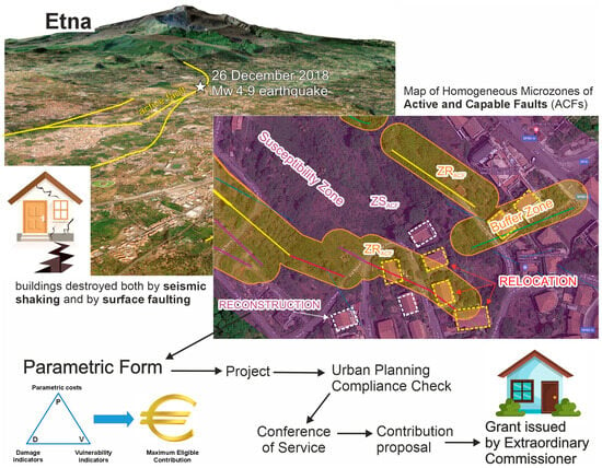
Post-disaster reconstruction requires instruments capable of ensuring procedural consistency, administrative transparency, and the systematic integration of geohazards, all of which are essential for safeguarding communities. This study presents the digital platform established under Italian Law 55/2019 for the reconstruction of the areas on Mt. Etna affected by the Mw 4.9 earthquake of 26 December 2018, emphasizing its innovative contribution to current international approaches to reconstruction governance. The platform standardizes the entire administrative workflow and is centered on the Parametric Form, which enables an objective calculation of eligible reconstruction grants based on damage indicators, vulnerability metrics, and parametric cost functions. A defining feature of the Etna model is the structural integration between administrative procedures and geohazard mitigation, achieved through updated hazard maps and protocols that incorporate geological, hydrogeological, and geomorphological conditions. This approach reframes reconstruction as an opportunity to reduce overall territorial vulnerability. The system also includes public monitoring tools (WebGIS and dashboards) that enhance traceability, compliance, and stakeholder engagement. Expected outcomes include shorter administrative timelines, improved interinstitutional coordination, and the potential transferability of the model to other emergency contexts. In comparison with international cases, the Etna experience represents an original integration of digitalization, parametric assessment, and site-specific hazard mitigation.

Graphical Abstract

1. Introduction

The management of post-earthquake reconstruction processes represents one of the most complex challenges for institutional systems and civil protection authorities, as it requires the coordination of multiple actors, the application of complex regulatory procedures, and, above all, the integration of scientific knowledge related to geological and territorial hazards. It is evident that the more severe a natural disaster is, the greater its impact on the affected area; however, in densely urbanized regions, even moderate-magnitude events can cause significant damage to buildings and infrastructure, making public institutional intervention essential to support communities in managing and recovering from the emergency.
In recent years, scientific and technical literature has demonstrated that the digitalization of administrative processes is a key factor in improving efficiency, transparency, and institutional resilience, particularly in emergency contexts [1,2]. Several studies have highlighted the role of digital platforms in managing building procedures and post-disaster reconstruction [3], with documented benefits in terms of reduced processing times, procedural traceability, and data accessibility.
In Italy, significant experiences were gained following the 2009 (L’Aquila) and 2016 (Central Italy) earthquakes, with the launch of digitalization projects for building procedures and the creation of centralized electronic archives (https://usra.it/ricostruzione-privata-2/ (accessed on 20 January 2026)) [4,5,6]. At the same time, cooperation protocols among Extraordinary Commissioners, Heritage and Landscape Superintendences, and anti-mafia prevention structures strengthened transparency and compliance in reconstruction processes [7]. Methodological documents such as the Vademecum Ricostruzione Sisma 2016 [1] consolidated best practices, emphasizing the importance of digital tools for standardization and enhanced oversight. These experiences helped consolidate the notion that reconstruction should not merely restore pre-existing conditions, but rather serve as an opportunity to reduce the overall vulnerability of settlements and mitigate future risks. A regulatory turning point was introduced by Law No. 40 of 18 March 2025 [8], which established an organic framework for emergency management and reconstruction.
Within this framework, the ordinances issued by the Extraordinary Commissioner appointed by the Italian Government for the reconstruction of the areas affected by the 26 December 2018 Mt. Etna earthquake [9] defined uniform operational procedures and standardized criteria for accessing reconstruction grants in the affected municipalities, in accordance with the regulations specifically enacted for this event [10,11].
The Etna reconstruction has been characterized from the outset by the systematic use of a dedicated digital platform, previously tested in the 2009–2016 post-earthquake reconstructions [4,5] and, from 2019 onward, further developed and refined by the Office of the Extraordinary Commissioner for the Reconstruction of the Etna Area (SCRAE). This tool enabled the complete digitalization of the administrative workflow, from application submission to grant allocation, disbursement, and project implementation. A cornerstone of the system is the Parametric Form [12], which determines the eligible financial contribution based on objective criteria related to damage, vulnerability, and parametric reconstruction costs.
The truly innovative element, however, lies in the integration between administrative management and geohazard mitigation. The platform is grounded in a preliminary assessment of local hazards, the production and continuous updating of geohazard maps, and the application of advanced procedures that account for geological, hydrogeological, and geomorphological constraints. In this way, reconstruction is not conceived as mere repair, but as a resilient regeneration process capable of reducing future risks and enhancing community safety.
The objective of this work is twofold: first, to illustrate the architecture and main functionalities of the digital platform, highlighting its benefits in terms of administrative simplification, transparency, social equity, and full compliance with legal requirements; second, to discuss how the integration of geohazard assessment and monitoring tools represents a significant methodological advancement, capable of transforming reconstruction into an opportunity for structural and territorial risk mitigation.
In this perspective, the present study provides an original scientific contribution by demonstrating how a fully integrated system—combining digital governance, standardized assessment procedures, and geohazard-informed decision-making—can operate as a coherent methodological framework for post-disaster reconstruction. Beyond documenting the Etna case, the work advances existing practices by showing how administrative digitalization, parametric evaluation, and systematic hazard characterization can be jointly operationalized to enhance transparency, reduce procedural variability, and support risk-aware design choices. The resulting framework offers transferable insights for international reconstruction contexts, where the need for resilient, data-driven, and legally robust approaches is increasingly recognized.

2. Reconstruction Workflow: Methods and Operational Framework

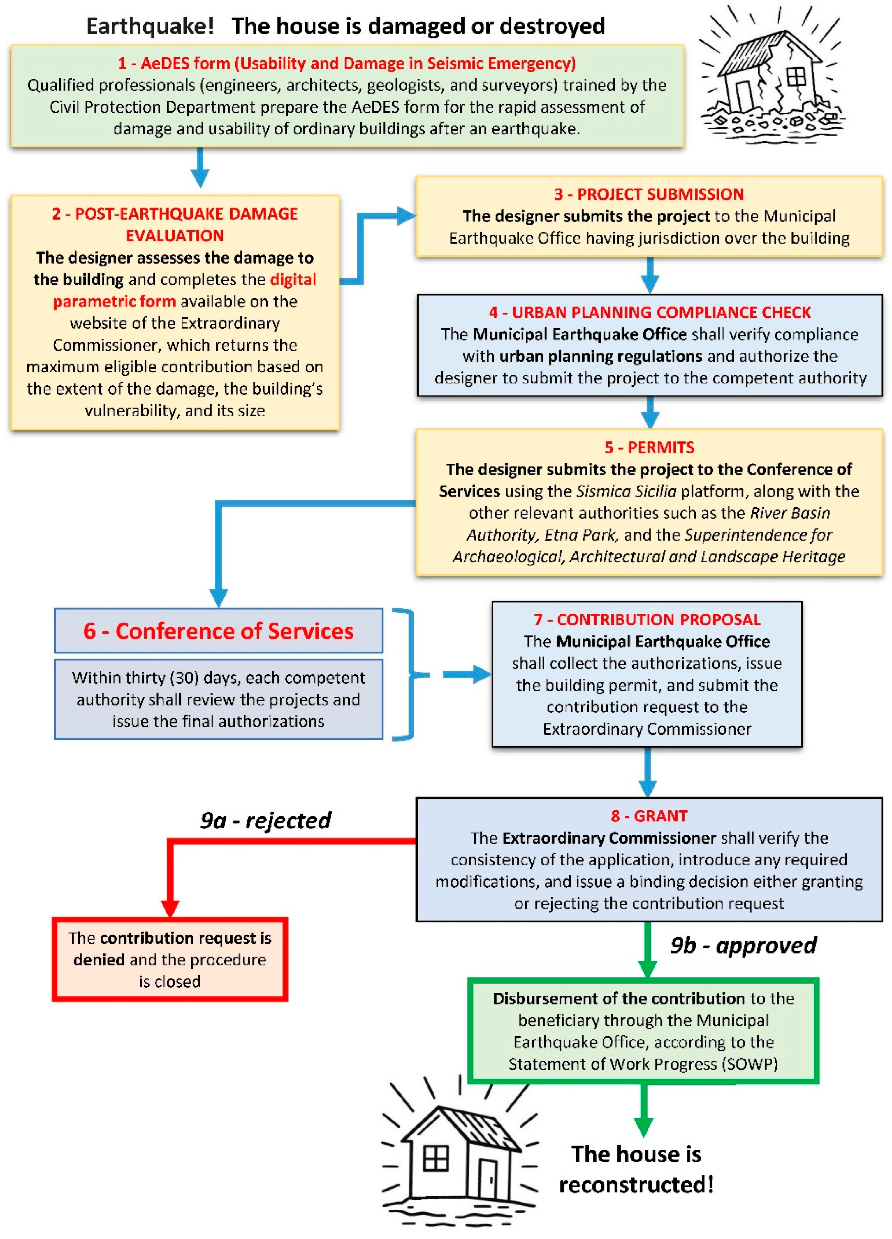
In the context of post-earthquake reconstruction in Italy, the AeDES form (Agibilità e Danno nell’Emergenza Sismica) [13], see Step 1 in Figure 1, represents the first official tool for recording building damage and assessing the usability of ordinary structures. It is completed in the days immediately following the event and provides a rapid initial survey of damage. In particular, the assignment of a “B”, “C”, or “E” outcome (indicating, respectively, a temporarily, partially, or totally unusable building) in each AeDES form is a necessary condition for eligibility for public reconstruction funding, as established by the legislation enacted for the 2018 post-earthquake reconstruction [10,11]. Conversely, an “A” outcome does not entitle the owner to any public contribution, as the building is considered usable.
In the area affected by the Etna earthquake, more than 7000 AeDES forms were completed, of which just over 3000 received a B, C, or E outcome. Based on this dataset, the Extraordinary Commissioner appointed by the Italian Government defined the operational procedure illustrated in Figure 1, which specifies the entire workflow for reconstruction and involves numerous public and private actors. According to this scheme, the first step consists of a detailed damage assessment carried out by the designer (engineer, architect, or surveyor), who expands upon the information already contained in the AeDES form and subsequently completes a digital and interactive Parametric Form [12], available on the Commissioner’s institutional platform (Step 2 in Figure 1). This tool enables the automated calculation of the maximum eligible reconstruction grant that the Commissioner may allocate for each building, based on variables such as the extent of damage, the vulnerability of the structure, the parametric reconstruction cost linked to its size, and the geological context in which the building is located.
The designer then prepares the technical proposal and submits it to the municipal Earthquake Office (Ufficio Sisma) with territorial jurisdiction for verification of urban-planning compliance (Steps 3–4). The designer subsequently obtains the required authorizations and technical opinions from the other competent offices involved in the permitting process—such as the Civil Engineering Office (Genio Civile), River Basin Authority, Regional Forestry Inspectorate, Park Authority, and the Heritage and Landscape Superintendence (Soprintendenza per i Beni Archeologici, Architettonici e Paesaggistici)—through an asynchronous Conference of Services (Steps 5–6). The Extraordinary Commissioner oversees the process to ensure that each authority issues its authorization or clearance within thirty days, in accordance with its respective responsibilities.
The municipal Earthquake Office collects all authorizations and, if the outcome is positive, issues the urban-planning compliance certificate and forwards the proposed reconstruction grant to the Extraordinary Commissioner (Step 7). The Commissioner verifies the completeness and consistency of the application (Step 8), requests any necessary revisions, and subsequently issues the final decision approving or rejecting the grant request (Steps 9a–9b). If approved, the Extraordinary Commissioner transfers the allocated funds to the municipality, which disburses the grant to the beneficiary through the municipal Earthquake Office based on the certified Statements of Work Progress (Step 9b). Once reconstruction works are completed and the building’s unusability status is formally revoked, the procedure is closed and residents can return to their homes.
The entire process is monitored by the Extraordinary Commissioner and can be viewed both by citizens (https://commissariosismaareaetnea.it/it/page/mappa-della-ricostruzione (accessed on 20 January 2026)) and by the competent regional technical authorities through restricted access to the Parametric Form (https://www.scrae.it/bdeRicostruzione/index (accessed on 20 January 2026)). In cases of unjustified delays by public bodies in issuing their required opinions, or in cases where designers fail to update project documentation within the legally established deadlines, the Commissioner formally requests compliance from the responsible offices or professionals and archives incomplete or incorrect grant applications without disbursing any funds.
This methodological sequence is designed to ensure that all administrative steps required for reconstruction are efficient, timely, fully traceable, and procedurally uniform, while minimizing the risk of discretionary or inappropriate actions. It also guarantees that the disbursement of public funds occurs promptly and in accordance with principles of objectivity, equity, and full compliance with all applicable regulations. Moreover, this approach highlights the importance of digitalizing decision-making processes—through the Parametric Form and institutional digital platforms—as tools for bureaucratic simplification and cross-checking of procedures, thereby promoting integrated and coordinated management among national, regional, and municipal institutions.
In the following sections, we describe in detail the architecture of the Parametric Form developed to manage the post-2018 reconstruction process, discussing its rationale, purpose, and the improvements it introduced in reconstruction governance. We also examine the challenges encountered, the solutions adopted, and the potential transferability of this methodology to other territorial and disaster contexts in Italy and worldwide.

3. Results

The Parametric Form is a digital, interactive, and editable tool adopted by the Extraordinary Commissioner for the 2018 earthquake in accordance with the legislation enacted to address this event [10,11]. This methodology, already successfully tested following the L’Aquila earthquake of 6 April 2009 [4], has proven particularly effective in the reconstruction of earthquake-damaged towns, introducing criteria of uniformity and equity in both damage assessment and the corresponding reconstruction costs.
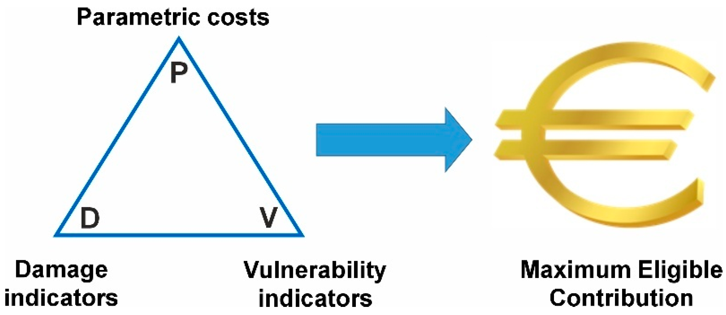
The maximum eligible contribution that may be granted to eligible beneficiaries is calculated through a damage–vulnerability–parametric-cost correlation matrix (Figure 2), based on the construction characteristics of each building, its dimensions, and the geological context in which it is located. The designer therefore has a clear economic reference parameter on which to base the repair or reconstruction project: if the project cost is lower than the maximum eligible contribution, the entire amount can be reimbursed through the grant provided by the Extraordinary Commissioner; if the cost exceeds this threshold, the difference must be covered by the applicant.

3.1. The Parametric Form

Repair or reconstruction projects must be prepared for a “minimum intervention unit,” which may consist of a single Structural Unit (in the case of an individual building) or multiple Structural Units (i.e., an “aggregate” of structurally interconnected buildings). The eligible financial contribution is determined as the sum of the compensations calculated for each individual Structural Unit.
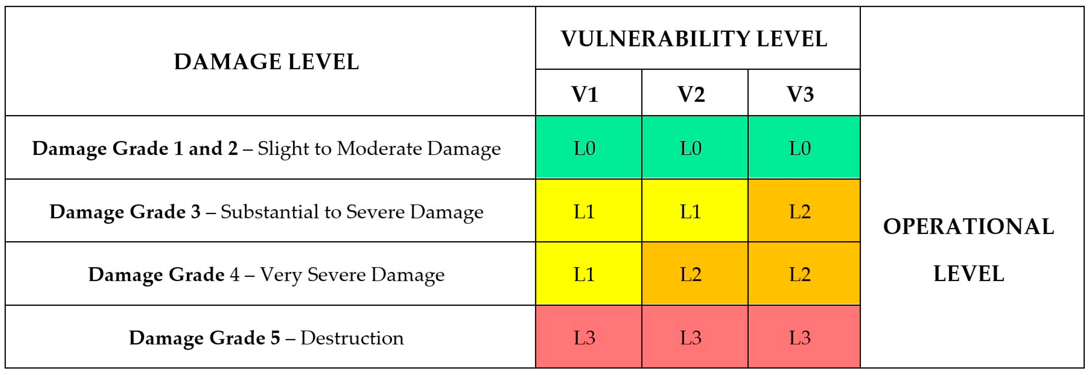
The economic contribution for each Structural Unit is determined on the basis of a damage–vulnerability analysis carried out by the designer, applying the correlation matrix presented in Figure 3.
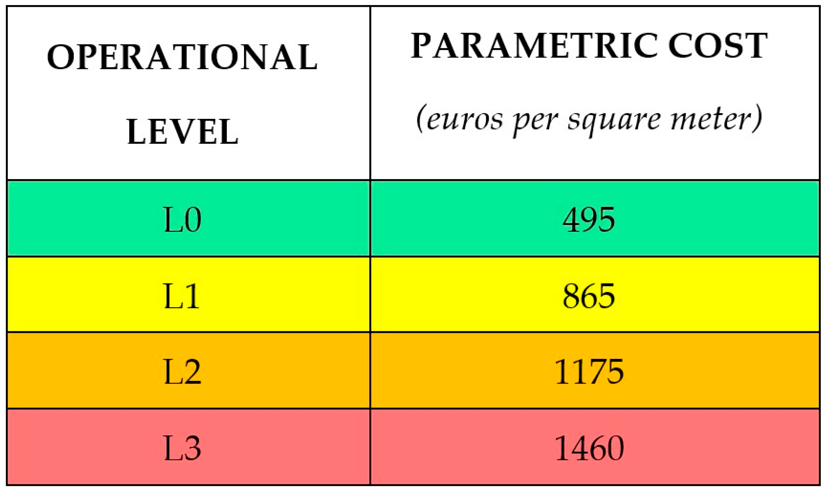
The correlation between damage and vulnerability identifies four Operational Levels, each associated with a corresponding parametric reconstruction cost expressed in euros per square meter (see Figure 4). Damage assessment is carried out by applying the same criteria used for completing the AeDES form [13], which is employed during the emergency phase to determine the usability outcomes of earthquake-affected buildings.
Figure 4. Parametric reconstruction costs per square meter in the Etna area. These values are updated by the Extraordinary Commissioner according to the revisions introduced in the Regional Unit Price List for public works, prepared by the Regional Technical Department—Regional Price List Commission and approved by decree of the Department of Infrastructure and Mobility of the Sicilian Region [14]. The colours indicate the progressive increase in parametric reconstruction cost associated with the operational levels from L0 (green) to L3 (red).
Geohazards 07 00016 g004
Vulnerability, on the other hand, is determined through dedicated descriptive fields included in the Parametric Form, which guide the designer in identifying the main construction deficiencies of the earthquake-affected building. The parametric reconstruction costs per square meter associated with each of the four Operational Levels (Figure 4) are calculated by the Extraordinary Commissioner based on the indications provided in the Regional Unit Price List for public works [14].
In addition, the Parametric Form allows for the calculation of possible increases in parametric costs, expressed as percentage increments, in the case of buildings located within “A-zones” of municipal master plans (+5%), buildings with an average interstory height greater than 3.50 m (+8%), buildings officially designated as being of cultural interest (+20%), buildings subject to specific landscape protection constraints (+10%), and buildings situated in areas affected by local seismic amplification (up to +10%). In this latter case, the increase is derived from the Local Seismic Response Analysis (LSRA), which defines site-specific seismic parameters—such as maximum horizontal acceleration, stratigraphic and topographic amplification coefficients, and expected peak ground acceleration at the site—that directly influence the structural design. Higher local seismic demand requires more stringent and costly seismic-resistant measures, and the Parametric Form accounts for this by allowing cost adjustments of up to 10%.
Each fully completed form contains approximately 150 fields in the summary section and approximately 1500 fields in the detailed sections, compiled for each Structural Unit. This extensive dataset enables an effective and comprehensive system for controlling and monitoring post-earthquake activities across multiple domains, including work progress, economic and financial management, and legal and fiscal compliance. The system also supports the use of GIS platforms for managing activities planned across the affected territory, including periodic site inspections carried out to verify construction progress and the consistency of the works with the approved project.

3.2. Structure of the Parametric Form

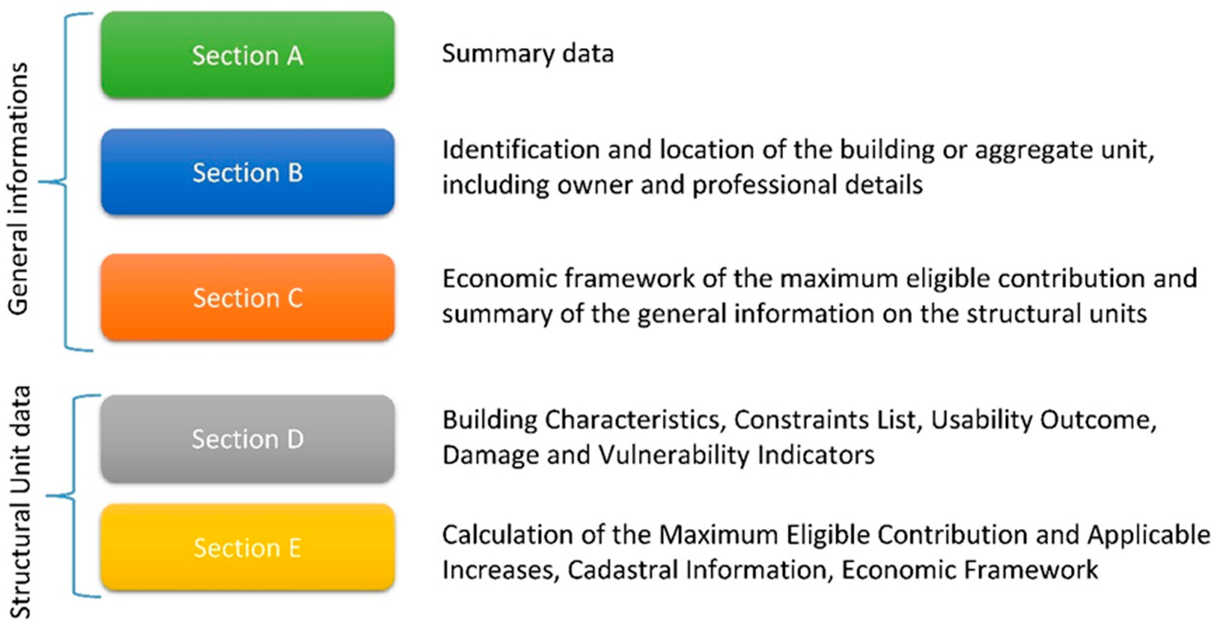
The Parametric Form is composed of five distinct sections, each requiring the entry of specific categories of data (Figure 5).
Section A of the Parametric Form reports the summary data obtained from the automatic processing of the information entered in the other sections. Consequently, this section contains only auto-generated, non-editable fields. It also includes a “Print” button, which allows the user to print the entire Parametric Form once completed, to be attached to the grant application. Section B contains the data required for locating and identifying the building, as well as information on the owner, the professionals responsible for preparing the project, and the construction company appointed to carry out the works.
Section C provides the economic framework of the maximum eligible contribution and a general summary of the data relating to the Structural Units. Section D allows for the entry of detailed information for each individual residential Structural Unit, including its construction characteristics, any applicable urban-planning or landscape constraints, the usability outcome derived from the AeDES form, and the indicators of damage and vulnerability. Section E calculates the base contribution (obtained using the parametric costs shown in Figure 4) and any applicable increases, which together determine the maximum contribution that may be granted by the Extraordinary Commissioner. This calculation is performed after entering the cadastral data and surface areas of the property, and it provides the final economic summary for the Structural Unit under consideration.

3.3. Assessment of the Damage Sustained by the Building During the Earthquake

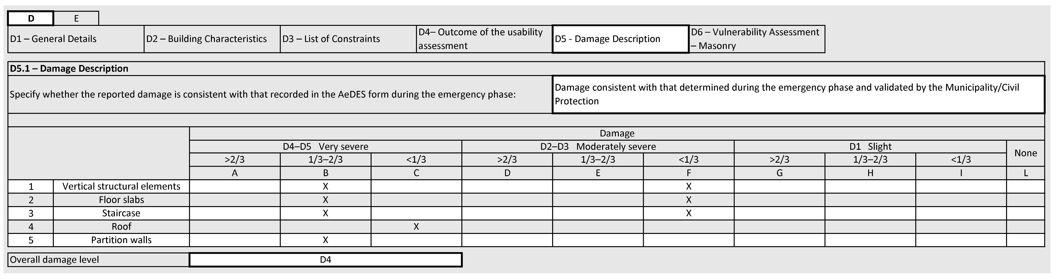
The data used to characterize and quantify the “damage” caused by the earthquake must be entered in Section D.5 of the Parametric Form, an example of which is shown in Figure 6. The following paragraphs provide a brief illustrative summary of the type of information to be entered in this section, while a detailed description is made available to designers on the website of the Commissioner’s Office [12].
The first four rows of Section D.5 refer to the main structural elements of the building—namely vertical structural components, floor slabs, staircases, and the roof. Row 5 concerns infill walls and partitions, which are non-structural elements but are nonetheless highly relevant because they can modify the strength and/or seismic response of the building. The columns are organized to allow the designer to specify both the damage level (slight–moderate–severe–very severe) and its extent (less than one-third of the element considered, between one-third and two-thirds, or greater than two-thirds). Data entry is simplified by the fact that the user only needs to select the corresponding cells: each cell represents a specific damage level and a specific extent of that damage. All listed components (rows 1 to 5) must be evaluated; if no damage is observed for a given component, the “None” cell is selected and no other fields in that row are completed.
The estimation of damage extent must be carried out separately for each row of Section D.5 and with reference to the entire building under examination. This means that for each component listed, the designer must:
  • Identify the presence of each of the three damage levels;
  • Estimate the extent to be assigned to each level by calculating both the percentage ratio, on each floor, between the damaged portions or surfaces and the total portions or surfaces of that floor, and the percentage ratio between the number of damaged floors and the total number of floors.
For example, if in a three-story masonry building the D2–D3 damage level affects 60% of the walls only on the ground floor, with no damage on the upper two floors, the extent for the entire building will be:
60% × 1/3 = 20%, which corresponds to <1/3 (row 1, column F).

3.4. Vulnerability of Masonry Buildings

The vulnerability of masonry buildings is determined using a simplified model based on the analysis of the construction typology of the Structural Unit and the main construction deficiencies, which are interpreted as indicators of vulnerability.
The vulnerability assessment follows the same criteria adopted in previous post-earthquake reconstruction programs in Italy [4,5]—already validated on many tens of thousands of buildings—and the guidelines of the AeDES manual [13]. The Parametric Form used here derives from those earlier applications, with minor adaptations to the Etnean building stock. During the implementation phase, a preliminary sensitivity check was performed by varying the main vulnerability parameters by ±1 class, confirming the stability of the resulting vulnerability rankings.
The Parametric Form guides the designer in identifying these deficiencies through a logical sequence that also supports the selection of the interventions required to eliminate and/or mitigate the identified vulnerabilities. For example, masonry quality can be improved through consolidation works, whereas some deficiencies—such as excessively large spacing between load-bearing walls—cannot always be reduced. In such cases, the residual vulnerability must be evaluated within the broader context of the urban-planning and landscape constraints to which the building is subject.
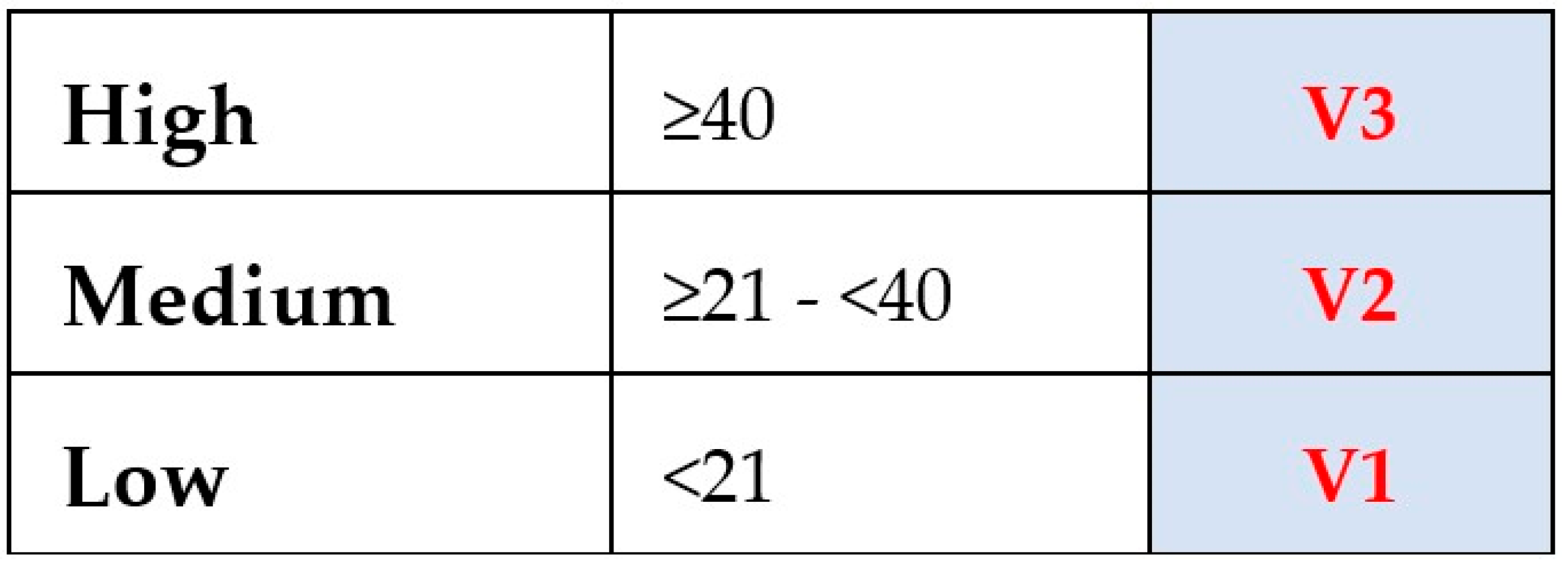
The vulnerability of masonry buildings is determined by assigning a score to each construction typology or deficiency, classified into three levels (see Figure 7). Each level is calculated based on building-specific data, which can be obtained using Table 1. High vulnerability (V3) is assigned when the score is greater than or equal to 40; medium vulnerability (V2) corresponds to scores between 21 and 40; and low vulnerability (V1) is assigned for scores below 21.

3.5. Vulnerability of Reinforced Concrete Buildings

Similarly to what has been described for masonry buildings, the vulnerability of reinforced concrete or steel buildings is determined using a simplified model based on the analysis of the construction typology of the Structural Unit and the main construction deficiencies, which are interpreted as indicators of vulnerability [12]. In this case as well, the Parametric Form guides the designer in identifying these deficiencies through a logical sequence that also supports the selection of the interventions required to eliminate and/or mitigate the identified vulnerabilities.
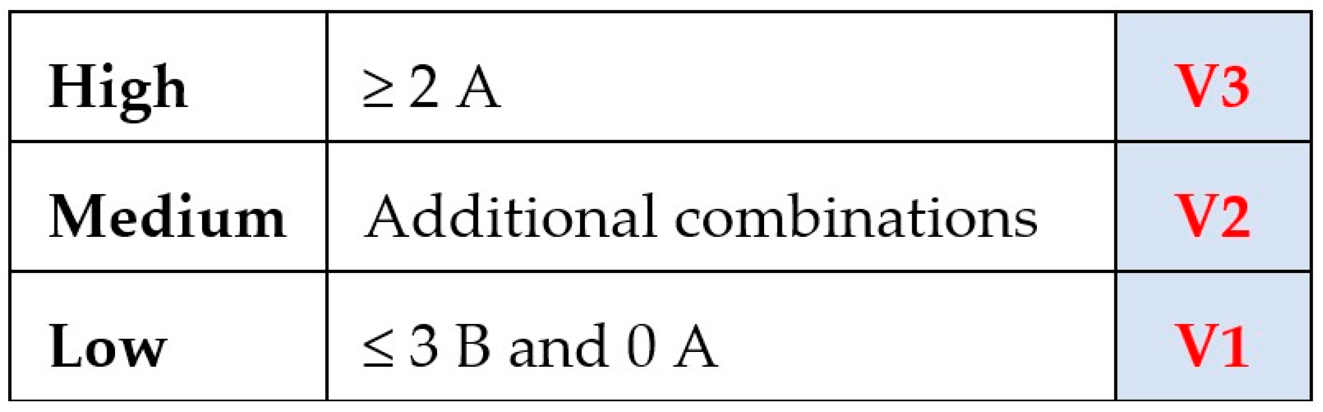
Vulnerability is classified into three levels—high, medium, and low (Figure 8). Each construction deficiency is assigned to one of two classes: A (primary) or B (secondary) (see Table 2). High vulnerability (V3) is assigned when at least two Class-A deficiencies are present; low vulnerability (V1) is assigned when fewer than three Class-B deficiencies are present and none of Class A; and medium vulnerability (V2) applies in all other cases.
Table 2 provides an example of vulnerability indicators for reinforced concrete buildings, including their classification and the corresponding scores used for the calculation (the total score is shown solely for statistical purposes).

3.6. Quantitative Characterization of Building Damage

A total of 735 buildings—corresponding to 40% of the damaged private stock—exhibited minor damage, with repair costs not exceeding €80,000. Conversely, 537 buildings sustained major or severe damage, in many cases requiring demolition and reconstruction, with an average intervention cost of approximately €350,000 per housing unit. The most severe impacts were observed in older masonry buildings, widespread in the Etna area and typically constructed using locally available lava stone. These structures, generally more than 70 years old, showed significant degradation of the original mortar and required extensive strengthening of load-bearing walls. In about 20% of these cases, the original masonry buildings were replaced with new reinforced-concrete structures, providing substantially higher seismic resistance and improving long-term safety for residents. Finally, in 5% of the cases (65 buildings), a relocation measure was adopted because they were situated in areas excessively exposed to seismic risk. In these situations, the unsafe buildings were demolished and rebuilt elsewhere, or an economic contribution equivalent to the value of the relocated building was granted to allow the purchase of an existing property.

3.7. Vulnerability to Geological Hazards

The 26 December 2018 earthquake generated coseismic surface ruptures extending for approximately 8–10 km, mainly along the structure known as the Fiandaca Fault [15], and references therein. The surface rupture zones vary in width from a few meters to several tens of meters. Southward, the Fiandaca Fault connects with the Aci Catena and Aci Platani faults, which were also affected to varying degrees by the coseismic faulting.
In the first months following its establishment in January 2020, the Commissioner’s Office produced Maps of Homogeneous Microzones of Active and Capable Faults (ACF) and Hydrogeological Instability Maps (2020). The classification of ACF zones was conducted in accordance with the guidelines for the management of the territory in areas affected by active and capable faults (ACF) [16] and follows a reproducible set of geomorphological and structural criteria. Each ACF segment was assigned to a class based on: (i) its spatial relationship with the main tectonic lineaments mapped in the study area (e.g., structural maps and fault-kinematic datasets; [15], and references therein; (ii) the degree of morphological expression, continuity and sharpness of the ACF traces; and (iii) the coherence between ACF orientation and the regional stress field documented in previous seismotectonic studies [17].
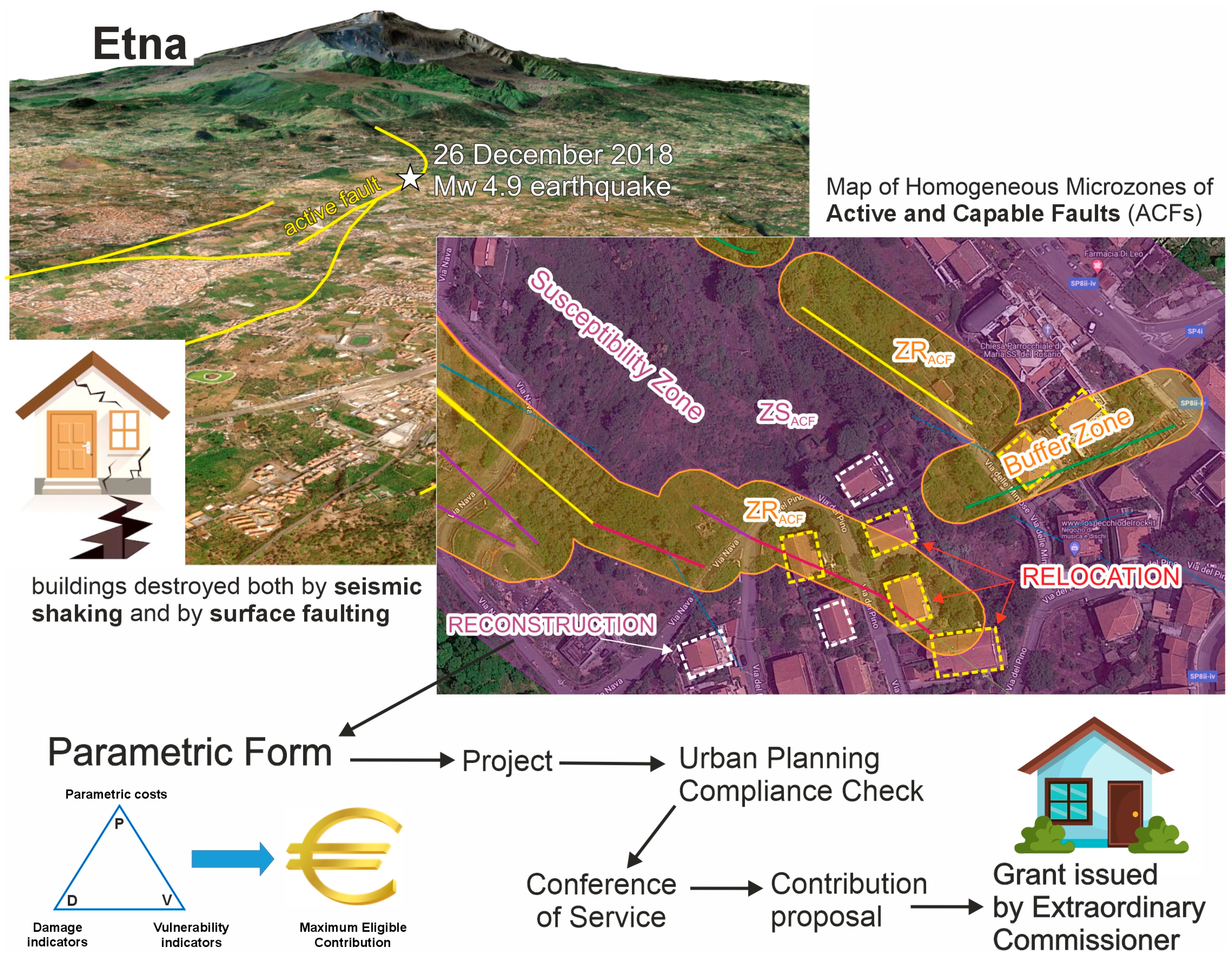
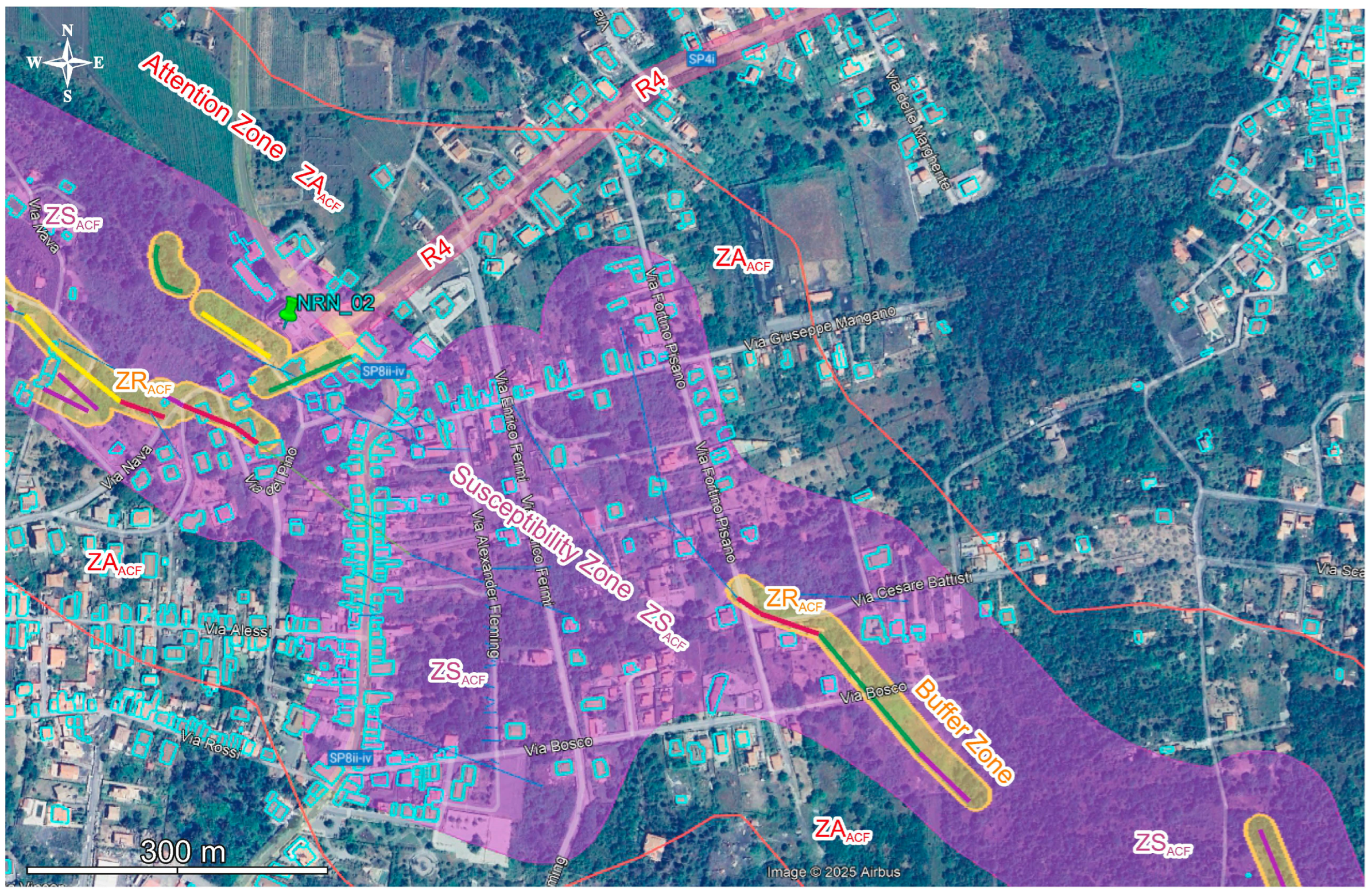
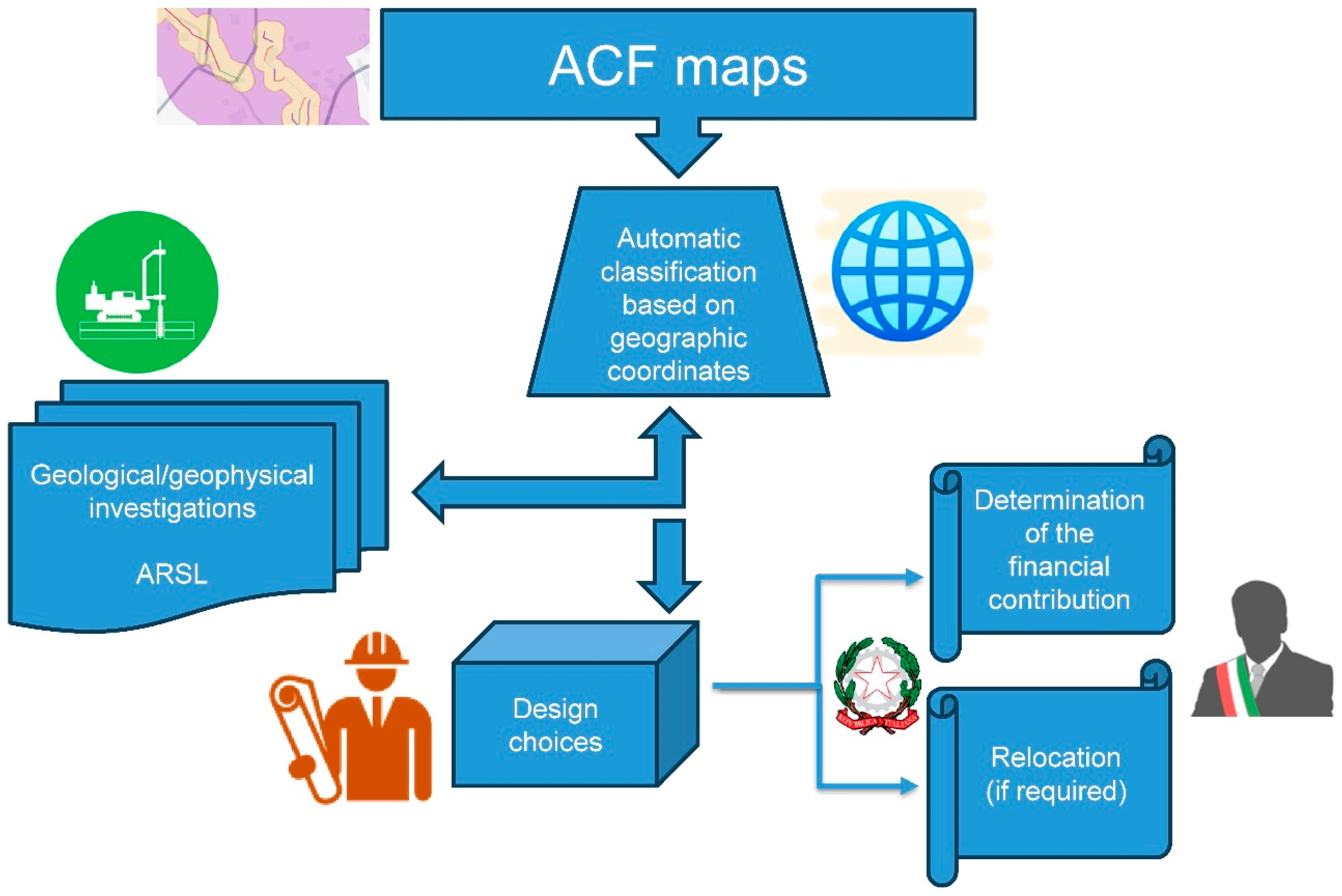
These maps highlight the areas affected by coseismic faulting and those most exposed to morpho-hydrogeological hazards, identifying ACF Attention Zones (ZAACF), ACF Susceptibility Zones (ZSACF), and ACF Buffer Zones (ZRACF), which represent progressively increasing levels of hazard (Figure 9). Consequently, every building to be reconstructed must be georeferenced, and the corresponding coordinates must be entered into the Parametric Form, which automatically determines whether the site falls inside or outside one of these hazardous zones.
Based on these maps, the Extraordinary Commissioner adopted a Relocation Plan (2020) for the buildings affected by the 2018 earthquake and declared uninhabitable following AeDES inspections with outcomes B, C, and E, located within the ACF Buffer Zone (ZRACF) of the active and capable faults (Figure 9). These buildings are indeed those most exposed to potential future seismic induced damage, given the high frequency of seismic events along the Fiandaca Fault, the tectonic structure that generated the 26 December 2018 earthquake [17,18,19].
Figure 9. Example of Maps of Homogeneous Microzones of Active and Capable Faults (ACF) and Hydrogeological Instability Maps [20] in the Fleri area. The maps highlight the areas affected by coseismic faulting (red, green, purple, and blue lines) and those most exposed to morpho-hydrogeological hazards, identifying ACF Attention Zones (ZAACF), ACF Susceptibility Zones (ZSACF), and ACF Buffer Zones (ZRACF), as well as areas subject to hydraulic hazard (R4 = Very High). The footprints of buildings rendered uninhabitable by the earthquake are outlined in light blue.
Geohazards 07 00016 g009
Eligible beneficiaries [21] are granted a contribution aimed at relocating their home exclusively within the territory of one of the municipalities affected by the 2018 earthquake. Relocation may occur by:
  • Reconstructing the building in another site that is not hazardous and not susceptible to severe dynamic instability;
  • Purchasing another equivalent existing building, provided it is habitable and compliant with urban planning, building, and seismic regulations.
Ultimately, through the Relocation Plan, it was possible to reduce urbanization in the most hazardous areas of the territory, safeguarding the lives of residents and relocating them to safer zones [22,23]. Furthermore, the areas cleared of debris from the relocated buildings were transferred free of charge to the municipalities, which can regenerate these spaces by creating parking areas, urban parks, and green spaces—funded by the Extraordinary Commissioner—thus returning to the community risk-free areas that enhance the quality of life in the earthquake-affected region [22,23].
In cases where the buildings to be reconstructed do not fall within areas subject to seismic or geological hazards and were therefore not included in the Relocation Plan, the Extraordinary Commissioner issued additional ordinances requiring the execution of specific preliminary geological and geophysical investigations. These investigations are aimed at achieving the project objectives within the different geological, morpho-hydrogeological, and structural contexts.
Two possible scenarios were identified: buildings located within the ACF Attention Zone (ZAACF), and buildings located outside it.
In the first case, the geological study—an integral part of the reconstruction project—must categorically exclude the presence of surface faulting or any other clear fracturing or permanent morphological modification of the ground caused by the earthquake, within a radius of at least 30 m from the building footprint. The study must be supported by at least one seismic refraction profile with tomographic processing, with a minimum length of 60 m, in order to obtain a 2D resolution suitable for identifying horizontal variations associated with geostructural lineaments (faults and fractures). It must also include at least one passive seismic test using the single-station HVSR (Horizontal to Vertical Spectral Ratio) method, aimed at identifying soft cover deposits overlying a stiffer shallow substrate, as impedance contrast between seismic units is a key factor governing seismic amplification. The HVSR analysis must determine the site’s fundamental (resonance) frequency, identify the possible seismic bedrock, and evaluate the equivalent Vs parameter. If the results of these investigations are insufficient to clarify the geological-structural characteristics of the site, additional geophysical (e.g., electrical resistivity, seismic reflection) and geognostic investigations may be carried out.
If the building to be reconstructed is located outside the ACF Attention Zone (ZAACF), the geological study must still certify the absence of surface faulting or any other clear fracturing or permanent morphological modification of the ground. It must also be supported by at least one active-source geophysical investigation of the MASW type (Multi-channel Analysis of Surface Waves), in order to reconstruct a 1D shear-wave velocity profile; to calculate the equivalent Vs parameter required to define the soil category according to the Italian Technical Standards [24] and the associated response spectrum; and to identify sub-foundation seismostratigraphic horizons characterized by high seismic impedance contrast.
Additional investigations may also be included if deemed necessary by the geologist responsible for developing the geological model, based on the characteristics of the structures and the geological-structural context of the substrate. These additional investigations are nevertheless subject to the congruity assessment carried out by the Commissioner’s Office, which determines the amount of financial reimbursement to be granted to the earthquake-affected citizen.
Up to December 2025, more than 1400 site-specific geophysical investigations were carried out—at least one for every reconstruction project—including MASW profiles, seismic tomography, and HVSR measurements. These surveys substantially improved the geological and geophysical knowledge of the affected area and were systematically incorporated into the design process. Notably, 99% of the consulting geologists made their results publicly available, enabling the Civil Protection Authority to acquire a large volume of high-resolution data now being used in the ongoing seismic microzonation studies funded by the Sicilian Regional Government. Importantly, the investigations did not generally lead to reductions in soil-category parameters; on the contrary, in approximately 10% of the cases, they revealed poorer-than-expected subsurface conditions, requiring designers to adopt more stringent seismic criteria. Although this resulted in higher construction costs, it ensured that structural projects were developed on the basis of the actual subsurface conditions beneath each building rather than on hypothetical or generalized soil parameters. This State-funded, site-specific characterization represents a significant safety enhancement for both the territory and its residents, guaranteeing that seismic actions are evaluated with a level of detail and accuracy unprecedented in previous Italian reconstruction processes and preventing the risk of under-designed interventions.
The investigations described above are also aimed at developing the Local Seismic Response Analysis [24], i.e., the study of the ground response to a given seismic input, with the objective of predicting the expected ground motion at the surface over the lifetime of the structure. This information is then applied to the structural design in terms of:
  • The amplitude of the expected ground motion (peak ground acceleration);
  • The time history of the expected seismic accelerations;
  • The frequency content of the expected seismic motion, describing how the amplitudes are distributed across different frequencies;
  • Stresses and strains (relevant for liquefaction problems and for the stability of slopes and retaining structures).
To determine the local seismic response, the Italian Technical Standards [24] provide two distinct approaches:
  • A simplified approach, which—while still requiring geotechnical characterization of the soils within the significant volume—is based on classifying the subsoil according to the shear-wave velocity (Vs). For the purpose of identifying the subsoil category, classification is performed using the equivalent shear-wave velocity (VSeq) [24];
  • A rigorous approach, which relies on a full local seismic response analysis developed using appropriate software and acceleration time histories, based on site-specific seismic (Vs) and geotechnical (modulus reduction and damping curves) characterization.
The simplified approach cannot be used when the stratigraphic conditions and soil properties cannot be clearly assigned to the standard subsoil categories, nor in the presence of complex topographic conditions or for structures with a fundamental period greater than 4 s.
The results of all investigations, together with the findings of the geological and geophysical studies supporting the project, are entered into the Parametric Form and influence both the structural design calculations (Section D.1) and the determination of the maximum eligible cost. The underlying rationale is to provide a higher financial contribution when the project site is more exposed to seismic action or to geological and morpho-hydrogeological hazards, conditions that require the designer to adopt safer—and therefore more costly—reconstruction or retrofitting solutions.

3.8. Illustrative Example of the Calculation Workflow

To improve accessibility for international readers unfamiliar with Italian post-earthquake procedures, a compact illustrative example is provided below. The aim is not to reproduce the full regulatory framework of the Parametric Form, which is defined by national legislation, but to clarify the conceptual workflow linking damage assessment, vulnerability classification, and the determination of the eligible reconstruction grant.
A two-storey unreinforced masonry building (200 m2) shows moderate non-structural damage with no impairment of load-bearing elements. This corresponds to Damage Grade D2 and, given its construction features, to Vulnerability Level V2. According to the Parametric Form, this combination yields Operational Level L0, with a base parametric cost of 495 €/m2.
Additional adjustments include:
  • Building of cultural interest: +20% (=99 €/m2).
  • LSRA-based amplification: +10% (=49.5 €/m2).
The resulting final parametric cost is: 643.5 €/m2.
For a surface of 200 m2, the base repair cost is: 128,700 €.
The Parametric Form then adds:
  • Technical investigations (2%) → 2574 €.
  • Specialist studies (LSRA, 0.5%) → 643.5 €.
  • Design and professional services (12.5%) → 16,087.5 €.
The total eligible grant becomes:
128,700 + 2574 + 643.5 + 16,087.5 ≈ 148,005 €.
Starting from the base repair cost (128,700 €), the designer is free to define the most appropriate technical solution for restoring safety, selecting the interventions deemed necessary. The actual project cost may therefore differ from the parametric value: if the final cost is lower, the Extraordinary Commissioner still grants the full amount calculated through the Parametric Form; if it is higher, the excess remains the responsibility of the property owner. This mechanism ensures proportionality and transparency, discouraging oversized or unnecessarily expensive interventions that would not be justified by the observed level of damage.
This compact example illustrates how observed damage, vulnerability, and site-specific hazard conditions are combined into a transparent and reproducible financial determination, without providing operational details that remain defined by national legislation.

4. Discussion

4.1. Usefulness of the Parametric Form as a “Cadaster” of the Reconstruction

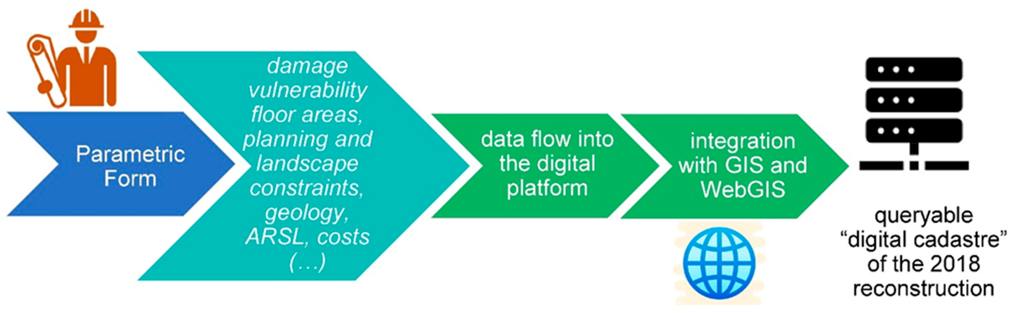
Within the Etna reconstruction framework, the Parametric Form operates as a true digital cadaster of the reconstruction process (Figure 10). By structuring technical and administrative information for each Structural Unit into a homogeneous and queryable archive, it enables the damaged building stock to be analyzed not only at the scale of individual procedures but as a territorial system.
Its capacity to aggregate data by construction typology, vulnerability, damage level, and local geological conditions makes it a strategic tool for interpreting the spatial distribution of fragilities and for supporting evidence-based planning. When integrated with GIS environments, the Parametric Form allows these patterns to be visualized and compared, strengthening the link between reconstruction choices, territorial characteristics, and hazard conditions.
This cadaster-like function also has long-term value. The structured dataset produced through the reconstruction process becomes a permanent knowledge base that supports monitoring, hazard-map refinement, and future planning decisions. In this sense, the Parametric Form contributes to building a shared and continuously updatable representation of the territory, enhancing institutional capacity for informed and timely action

4.2. Geohazard Mitigation

Within the Etna reconstruction framework, geohazard mitigation represents one of the most distinctive and innovative components of the methodological system adopted by the Extraordinary Commissioner. Unlike many post-earthquake reconstruction experiences—where the assessment of geological hazards remains confined to the design phase of individual interventions—the Etna case integrated this dimension from the outset as a structural element of reconstruction governance (Figure 11). This choice stems from the peculiar characteristics of the 26 December 2018 earthquake, which not only caused widespread damage to the building stock but also generated an extensive coseismic surface rupture along the Fiandaca Fault [15]. This rupture highlighted the presence of an active and capable tectonic system, characterized by a high frequency of reactivation [16] and by the potential for permanent ground deformation [9,18,25,26].
The institutional response to this complexity was grounded in the production of an updated and scientifically robust knowledge framework, which made it possible to integrate geological hazard directly into decision-making processes. In its first months of activity, the Commissioner’s Office developed the Maps of Active and Capable Faults (ACF) and the Hydrogeological Instability Maps [20], identifying three hazard classes—Attention Zones (ZAACF), Susceptibility Zones (ZSACF), and Buffer Zones (ZRACF)—representing a progressive gradient of risk associated with surface faulting, morphological instabilities, and critical geotechnical conditions. The mandatory inclusion of building coordinates in the Parametric Form enabled the automatic classification of sites with respect to these zones, transforming hazard assessment into a systematic and unavoidable step of the administrative process (Figure 11).
On this basis, the Relocation Plan [27] was developed, constituting a structural mitigation measure of particular significance at the national level. Buildings declared uninhabitable and located within the ACF Buffer Zone were excluded from in situ reconstruction, and owners were granted financial support to relocate to areas not exposed to surface faulting or dynamic instabilities [21]. This approach reduced urbanization in the most hazardous areas, decreasing population exposure to risk and returning to municipalities cleared areas that could be redeveloped for collective, risk-free functions. Relocation was therefore not merely an emergency measure but a territorial planning intervention oriented toward resilience [22,23], consistent with the view that reconstruction should serve as an opportunity to reduce the overall vulnerability of settlement systems, in line with recent legislative developments in Italy [8].
For buildings not subject to relocation, geohazard mitigation was pursued through a rigorous system of geological and geophysical investigations, differentiated according to their position relative to the mapped hazard zones. In sites closest to active faults, studies must conclusively exclude the presence of surface faulting and are supported by high-resolution investigations such as seismic refraction with tomographic processing, HVSR analyses, and, when necessary, additional geophysical and geotechnical surveys. In sites located outside the Attention Zone, geological characterization remains mandatory and requires at least one MASW survey to define the seismostratigraphic structure and the soil category in accordance with current technical standards [24,28]. In both cases, the collected information feeds into the Local Seismic Response Analysis (LSRA, Italian: Analisi di Risposta Sismica Locale, ARSL), which enables the estimation of expected surface ground motion (maximum horizontal acceleration, stratigraphic and topographic amplification coefficients, expected peak ground acceleration at the site) and the design of structures consistent with the dynamic conditions of the site [29].
Beyond these minimum requirements, the regulatory framework explicitly mandates that, whenever local geological conditions are particularly complex or when the baseline investigations do not allow the construction of a sufficiently robust subsurface model, the designer’s geologist must carry out all additional surveys necessary to achieve an adequate level of knowledge. In practice, numerous reconstruction projects included extensive investigative programs combining indirect geophysical methods (such as MASW, ReMi, HVSR, down-hole and cross-hole tests, and seismic refraction with tomographic processing) with direct investigations (rotary boreholes, mechanical test pits, and, in the most hazardous areas, full stratigraphic and paleoseismological trenches), ensuring that site characterization was always commensurate with the actual geological complexity.

4.2.1. Example of LSRA Application for a Minor Etna Earthquake (M 3.5–4.0)

To evaluate the scalability of the Etna reconstruction framework to lower-magnitude seismic events, a representative LSRA was performed for a local earthquake of magnitude ML≈3.8, hypocentral depth 6–8 km, and epicentral distance of approximately 8–10 km from the analyzed site. Although such events typically produce limited structural damage, they are frequent in the Etna region and provide a useful benchmark for testing the robustness of the adopted methodology.
Subsurface model
The geological and geophysical characterization (MASW, HVSR, geological survey) identified a three-layer structure:
0–8 m: pyroclastic and colluvial deposits, Vs ≈ 220 m/s;
8–22 m: altered and fractured lava flows, Vs ≈ 450 m/s;
>22 m: competent basaltic bedrock, Vs ≈ 800 m/s
The resulting Vs30 is approximately 320–340 m/s, corresponding to soil class C.
LSRA results
Using the regional bedrock spectrum (SLV) as input (PGA ≈ 0.22 g), the LSRA produced:
  • Surface PGA: 0.28–0.30 g (≈+25–35% amplification);
  • Stratigraphic amplification factor Fa: 1.3–1.4;
  • Fundamental site frequency: 1.5–1.8 Hz (HVSR peak), consistent with the estimated thickness of soft deposits.
Implications for design and risk reduction
The LSRA revealed a moderate but non-negligible amplification of seismic motion and a potential resonance with low- to mid-rise buildings (2–3 storeys). Compared with a standard class-C spectrum, the LSRA systematically increased design accelerations by approximately 20–30% in the period range relevant for such structures. This adjustment reduces the risk of underestimating seismic demand and demonstrates that the methodological framework—geophysical characterization, LSRA, and integration into the Parametric Form—remains effective and informative even for moderate-magnitude earthquakes typical of the Etna region.
These findings are consistent with the broader evidence collected during the reconstruction process. For a representative subset of projects affected by minor local earthquakes (M 3.5–4.0), LSRA applied to MASW-derived stratigraphic models systematically revealed stratigraphic amplification factors on the order of 1.3–1.4, with surface PGA values approximately 20–30% higher than the corresponding bedrock input. In several cases, site fundamental frequencies in the 1.5–2 Hz range overlapped with the natural periods of low- to mid-rise buildings, leading to more conservative design spectra and an explicit reduction in the risk of under-estimating seismic demand, even for moderate-magnitude events.
In all reconstruction cases, when discrepancies emerged between geological assessments and structural design assumptions, the geological evaluation prevailed, and the engineering design was systematically adjusted to the LSRA-derived site conditions, as required by the Parametric Form and the regulatory framework.

4.2.2. Comparative Applicability of the Etna Reconstruction Model to Minor Seismic Events

To assess whether the governance and geohazard-integration framework developed for the 26 December 2018 earthquake (Mw 4.9) is transferable to smaller and more frequent Etna earthquakes, two representative events of magnitude ML = 3.5–4.0 were examined. These events, although producing limited structural damage, are typical of the regional seismicity and provide a realistic test of the model’s scalability.
Event characteristics
Event A: ML = 3.6, depth 7 km, epicentral area between Zafferana and Milo.
Event B: ML = 3.9, depth 6 km, epicentral area near Santa Venerina. Both events generated peak ground accelerations at the surface of approximately 0.02–0.05 g, insufficient to cause widespread damage but capable of producing localized effects in vulnerable buildings.
Application of the model
The workflow used for the 2018 reconstruction—geological characterization, minimum geophysical investigations, LSRA, and integration into the Parametric Form—was applied conceptually to these minor events:
Geological and geophysical investigations: MASW and HVSR were sufficient to characterize the shallow stratigraphy and identify local amplification patterns, with no need for advanced fault-related investigations.
LSRA outcomes: stratigraphic amplification factors of 1.2–1.4 were observed, consistent with the presence of soft pyroclastic layers overlying basaltic bedrock.
Parametric implications: although the absolute seismic demand was lower than in 2018, the LSRA-derived spectra still produced non-negligible increases (15–25%) in design accelerations for low-rise buildings.
Governance and workflow: the digital platform, site classification logic, and hazard-integration procedures remained fully applicable, requiring only minor adjustments in the scale of investigations.
The comparison demonstrates that the Etna reconstruction model is not limited to moderate-magnitude earthquakes with surface faulting, but is also applicable to smaller and more frequent events. The methodological core—geohazard integration, LSRA, and digital governance—remains valid across different magnitudes, ensuring consistent and scalable risk-reduction outcomes.
Integrating these investigations into the Parametric Form introduces an additional level of methodological coherence, as the geological complexity of the site directly influences the quantification of the financial contribution and guides design choices toward safer solutions. In this way, the reconstruction process not only acknowledges geological hazards but transforms them into an operational criterion that shapes project decisions and incentivizes safer interventions. Geohazard mitigation thus becomes a structural component of the entire process, fully aligned with the principles of transparency, traceability, and accountability that characterize the digital platform.
Although long-term climate-change-related trends (e.g., projected increases in hydrogeological instability) were not explicitly incorporated into the present hazard assessments, the reconstruction process systematically relied on certified and up-to-date morphological and hydrogeological data—primarily the Hydrogeological Instability Maps—which constitute the only legally valid and operationally actionable sources for building-scale decisions. As a result, the adopted framework is grounded in current, verified hazard conditions, while remaining fully compatible with the future integration of climate-scenario analyses as more spatially resolved projections become available.
The Etna experience demonstrates how an integrated approach—grounded in scientific knowledge, digital tools, and coherent administrative procedures—can significantly reduce risk exposure and contribute to building more resilient communities. From this perspective, geohazard mitigation is not an ancillary element but an essential dimension of reconstruction, capable of influencing the future safety of the territory and the quality of institutional decision-making. The integration of seismic microzonation, geotechnical analyses, numerical modeling, and digital administrative tools represents a replicable model for other emergency contexts, consistent with the most recent international recommendations on geological risk management and territorial resilience [30].

4.3. Usefulness of the Parametric Form for Ensuring Legality

In the context of the post-earthquake reconstruction of the Etna area, the issue of legality assumes a significance that goes beyond administrative compliance and becomes central to risk governance. Reconstruction is not merely a technical process of repairing damage; it is a complex operation that mobilizes substantial public resources, involves an articulated chain of economic actors, and unfolds in territories where criminal pressure may manifest in subtle and pervasive forms. In this scenario, the Parametric Form emerges as a tool that substantially contributes to building an institutional environment that is transparent, verifiable, and resistant to illicit interference.
The effectiveness of the Parametric Form—applied exclusively to the reconstruction of privately owned buildings—derives primarily from its ability to reduce discretion in administrative procedures. The assessment of damage, vulnerability, and eligible costs is carried out through objective and standardized criteria, limiting the possibility of divergent interpretations and ensuring uniform application of the rules. This standardization produces a systemic effect on the quality of decision-making: when each step is defined by verifiable parameters, opportunities for manipulation, overestimation, or improper insertions are significantly reduced. The Parametric Form thus becomes a device of procedural equity, capable of strengthening citizens’ trust, improving the effectiveness of controls, reducing litigation, and facilitating legal defense when necessary—ultimately giving concrete form to the general principles of legality, transparency, impartiality, and good administration.
The Parametric Form integrates into this system as a key informational node. Every piece of data entered—from the description of damage to the geological characteristics of the site—is recorded within the digital reconstruction platform and becomes part of an archive that supports anti-mafia and anti-corruption checks, identifies responsibilities, and enables the timely detection of fraud attempts, helping to prevent them and to apply the sanctions provided by law. These include administrative measures (revocation of the contribution, recovery of unduly received funds), accounting measures (notifications to the Court of Auditors), and criminal sanctions (as provided by Article 76 of Presidential Decree 445/2000 [31] for false declarations, and by Articles 316-ter, 640-bis, and 316-bis of the Italian Penal Code for unlawful receipt of public funds, aggravated fraud, and misappropriation).
Digital traceability, which documents every modification and validation, makes it possible to reconstruct the entire administrative process and identify anomalies. The platform also interfaces with the verification systems established by the protocol, enabling cross-checks of the companies involved, corporate changes, and labor flows. In this way, the Parametric Form not only ensures the technical correctness of evaluations but actively contributes to preventing criminal infiltration, becoming a tool of integrated oversight.
Another important aspect concerns the scientific verifiability of technical content. The Parametric Form incorporates information on structural damage, pre-existing vulnerability, and the geological and geomorphological conditions of the site, anchoring the determination of the financial contribution to a coherent and evidence-based knowledge framework. This integration reduces the likelihood of arbitrary assessments and strengthens the consistency between building reconstruction and risk mitigation. The transparency of the criteria also reduces informational asymmetries among citizens, professionals, and public administrations, facilitating the understanding of decisions and helping to reduce disputes.
The combination of the Parametric Form and the digital platform therefore produces effects that extend beyond the emergency phase. The structured collection of technical, administrative, and anti-mafia data generates a digital archive of great value for territorial planning and for defining risk-mitigation policies. This information base makes it possible to identify recurring vulnerability patterns, update hazard maps, and strengthen institutional capacity to prevent future risks. In this perspective, legality is not merely compliance with rules but becomes a component of territorial resilience, capable of influencing the quality of decisions and the safety of communities.
The Etna reconstruction experience thus shows how the integration of technical tools and digital platforms can transform reconstruction into a process oriented not only toward repairing damage but also toward improving the institutional system as a whole. Within this framework, the Parametric Form exemplifies how digitalization can strengthen transparency, traceability, and the prevention of criminal infiltration, offering a model that can be replicated in other emergency contexts and aligned with the most recent international recommendations on risk governance [30].
With regard to the reconstruction of public buildings and places of worship, this process falls within the framework established by the Protocol on Legality signed between the Anti-Mafia Earthquake Task Force and the Extraordinary Commissioner for Reconstruction [32]. This protocol—modeled on previous Italian post-earthquake experiences but adapted to the specificities of the Etna area—introduces an anti-mafia prevention system that operates along the entire supply chain of the companies involved. Mandatory registration in the Anti-Mafia Registry of Contractors, the extension of checks to all contracts and subcontracts regardless their value, automatic termination clauses in the event of an interdiction, traceability of financial and labor flows, and the obligation to report extortion attempts or criminal interference all contribute to creating an operational environment in which legality is monitored continuously and structurally.

4.4. Comparative Reconstruction Trajectories Across Recent Italian Earthquakes

The comparative analysis of post-earthquake reconstruction processes in Italy highlights substantial variability in both pace and effectiveness across the major seismic events of the past years. The 2009 L’Aquila case represents the most advanced trajectory, with private reconstruction reaching approximately 73–74% in terms of physical completion, and 98% of all private applications fully processed, while public works have stabilized at around 48% of completed interventions. These results, achieved after sixteen years, are supported by Ufficio Speciale per la Ricostruzione dell’Aquila data (https://usra.it/rapporto-stato-della-ricostruzione-al-6-aprile-2025/ (accessed on 20 January 2026)) and reflect a mature and institutionally consolidated reconstruction process.
In contrast, the 2016–2017 Central Italy sequence shows a reconstruction trajectory that, although significantly accelerated between 2021 and 2025, still lags behind other Italian post-earthquake cases. Recent reports (https://sisma2016.gov.it (accessed on 20 January 2026)) indicate that private reconstruction has now surpassed 40–50%, with a marked increase in liquidations (+22% in the first five months of 2025) and over 6.1 billion euros disbursed. Public reconstruction has also progressed, with more than 33% of interventions having approved projects or ongoing procurement procedures. While part of the delay is attributable to the shorter time elapsed since the event, structural and administrative fragmentation across a vast territory has played a major role in slowing early phases of the process.
The 2017 Ischia earthquake presents an even more constrained reconstruction dynamic, with private reconstruction reaching approximately 30–35% in terms of completed works, although over 70% of projects have already been initiated. Public reconstruction stands at around 20–22% (https://urly.it/31djm7 (accessed on 20 January 2026)). Persistent urban-planning constraints and the delayed issuance of implementing ordinances have played a decisive role in limiting operational capacity.
Conversely, the 2018 Mt. Etna earthquake displays a comparatively faster reconstruction pattern. In roughly six years of commissioner-led activity (December 2019–2025), private works have reached 55–60%, with 86–100% of administrative procedures already completed (Table 3). Public reconstruction stands at 20–21%, with comparable figures for places of worship (Table 4). This performance is largely explained by the localized nature of the damage and by a more streamlined administrative framework.
A closer examination of the temporal structure of the process shows that the Etna program required an average of 1736 days across six operational phases (Table 5), from the issuance of commissioner ordinances to the completion of building reconstruction. The duration associated with the ordinance phase refers exclusively to the initial study stage, which also included the preliminary geostructural assessment required for drafting the commissioner ordinances.
The longest mean intervals correspond to urban-compliance verification and the reconstruction stage, while shorter periods characterize the design phase and the congruity analysis and funding decree. This distribution highlights the sequential nature of the reconstruction pipeline and identifies the phases where procedural streamlining can most effectively reduce overall completion times.
In terms of timing, the average interval between the appointment of the Extraordinary Commissioner and the completion of a private-building reconstruction is 4.8 years, a value that—while not negligible—remains significantly lower than those observed in other post-seismic contexts.
Taken together, these cases demonstrate that reconstruction speed in Italy is shaped not only by the severity and distribution of physical damage but also by institutional design, regulatory clarity, and the administrative capabilities of local and national authorities. The observed disparities underscore the need for more adaptive governance models capable of responding to heterogeneous territorial conditions and reducing the latency between emergency response and the onset of effective reconstruction.

4.5. Comparison with Other Reconstruction Experiences Worldwide

In the international landscape, post-earthquake reconstruction experiences display a remarkable heterogeneity of approaches, reflecting wide institutional, cultural, and geological differences (see Table 6). In several Chinese contexts affected by major earthquakes—beginning with the Sichuan earthquake (M 7.9) of 12 May 2008, which caused more than sixty-nine thousand fatalities—reconstruction has been interpreted as a process of evolutionary resilience, characterized by strong state leadership and explicit objectives of socio-economic and urban transformation rather than simple restoration. Recent studies show that reconstruction governance was structured into successive phases—emergency, transition, reconstruction, and development—with continuous adjustments to plans in response to emerging challenges [33,34]. Within this framework, seismic and geological hazards were addressed through extensive zoning (non-buildable areas, mandatory relocations, reconstruction in new sites) and microzonation studies that guided the siting of new infrastructure, schools, hospitals, and residential districts, in line with the principles of the Build Back Better approach [35].
The reconstruction of Christchurch, New Zealand, following the 2010–2011 earthquake sequence (M 6.3–7.0), represents another emblematic case of centralized governance. The New Zealand government established the Canterbury Earthquake Recovery Authority (CERA), which coordinated an urban “blueprint” based on 17 anchor projects and a special regulatory framework designed to accelerate decisions and authorizations [36]. The geohazard dimension was particularly significant due to widespread liquefaction and differential settlement: entire residential areas were classified as “red zones” and permanently abandoned, while others underwent ground-improvement interventions. Digital tools primarily supported planning, GIS-based damage mapping, and permit management, but they did not evolve into a unified parametric instrument comparable to the Parametric Form adopted for the 2018 Etna earthquake or the 2009 L’Aquila earthquake.
Other contexts, such as Japan (Kobe earthquake, 1995, M 7.3) or Nepal (2015 earthquake, M 7.8), adopted different models, prioritizing urban regeneration and owner-driven reconstruction, respectively, with varying roles for microzonation and digital technologies [37,38]). In Japan, reconstruction was accompanied by a profound revision of seismic codes and major infrastructure renewal, whereas in Nepal the emphasis on owner-driven reconstruction required substantial investment in technical training and minimum safety standards, without, however, producing a centralized digital system for damage and vulnerability assessment.
A contrasting example is Haiti (2010, M 7.0), where the earthquake exposed the failure of multilevel governance and the near-total absence of geohazard integration in decision-making processes. Institutional fragmentation, overlapping international actors, and the lack of a unified regulatory and technical framework hindered reconstruction. The absence of microzonation, standardized damage-classification criteria, and digital traceability systems contributed to delays, inefficiencies, and unsafe rebuilding [39,40].
Turkey offers another significant case. Both the 1999 Izmit earthquake (M 7.6) and the 2023 seismic sequence (M 7.0–8.0) highlighted persistent weaknesses in centralized reconstruction systems, including insufficient enforcement of seismic codes, limited integration of geological hazards into urban-planning decisions, and the vulnerability of the existing building stock. Despite reforms introduced after 1999, the 2023 events revealed unresolved structural weaknesses and governance gaps [41,42].
At the same time, numerous studies have documented the emergence of integrated digital ecosystems based on GIS (Geographic Information System), BIM (Building Information Modeling), and cloud-edge platforms to coordinate actors, geological data, financial flows, and construction-site monitoring, outlining a global trend toward increasingly complex and interconnected reconstruction systems [43,44]. However, these tools rarely assume a direct normative role in determining financial contributions or in the parametric assessment of damage at the scale of individual buildings.
Compared with this broader international landscape—and acknowledging the substantial difference in earthquake magnitude, which naturally results in different levels of urban damage—the post-2018 Etna reconstruction displays several distinctive features. These include the direct integration of geohazard conditions into the determination of the financial contribution; the mandatory use of a Parametric Form operating at a micro-scale, building by building; and the presence of a unified “digital cadaster” that simultaneously functions as a technical archive, a governance tool, and a legality-control mechanism. This combination of digitalization, parametric evaluation, and site-specific hazard mitigation constitutes an original model in the international context, capable of integrating geological knowledge, administrative transparency, and territorial resilience within a single methodological architecture. As highlighted by recent analyses of the Etna 2018 reconstruction process [22,23], 100% of private-building applications were managed entirely through the digital platform, with a substantial reduction in processing times compared to previous post-earthquake experiences. Furthermore, approximately one-third of the reconstruction projects required advanced geological or geophysical investigations, including LSRA, confirming the centrality of hazard-informed procedures in the overall governance model.
Within this comparative framework, the case of Christchurch is particularly illustrative. The slow progress documented in New Zealand was partly linked to the absence of a unified parametric instrument, the need for repeated project revisions following updated geotechnical information, and the coexistence of multiple digital tools without a single regulatory backbone. The Etna 2018 framework addressed these limitations through the early and mandatory integration of LSRA into the Parametric Form, which directly linked local seismic conditions to reconstruction costs, and through the adoption of a single digital platform with normative value. This architecture minimized redesign cycles, reduced administrative fragmentation, and ensured that hazard-informed criteria were embedded in both technical and financial decisions from the outset.
It must nevertheless be acknowledged that the effectiveness of this model relies on a high level of institutional capacity, coordinated governance, and technical expertise; as a result, its full replication may be challenging in contexts where administrative structures are weaker or where digital and regulatory frameworks are less consolidated. A minimum set of conditions is required for the model to be transferable. At the data level, a basic geohazard infrastructure—fault mapping, geological and geophysical datasets, and a standardized digital archive—is essential to support parametric evaluation. At the institutional level, the model requires a coordinated administrative structure capable of enforcing mandatory digital procedures and applying hazard-informed criteria. These elements represent the foundational capacity needed for other regions to adopt a similar framework.
In this perspective, several components of the Etna model are potentially transferable even to regions with weaker institutional capacity. The use of low-cost geophysical methods (e.g., HVSR, MASW), simplified parametric tools for damage and cost assessment, and basic digital platforms for traceability can be implemented with limited resources and provide immediate gains in transparency and hazard awareness. However, full adaptation requires conditions that are often lacking in developing countries, including a stable regulatory framework, reliable geohazard datasets, trained technical personnel, and coordinated administrative structures. Without these elements, the integration of hazard data into financial and design decisions risks becoming inconsistent or non-binding, limiting the effectiveness of the model.
Beyond the operational outcomes, the Etna reconstruction framework also provides methodological and scientific contributions of broader relevance. The integration of geological hazard mapping, geophysical characterization, LSRA, and a parametric administrative tool into a unified digital workflow represents an innovative model for multi-layered risk governance. This approach demonstrates how scientific data can be systematically embedded into reconstruction procedures, reducing epistemic uncertainty and enabling reproducible, evidence-based decisions. The resulting dataset—standardized, georeferenced, and fully traceable—constitutes a valuable resource for future research on vulnerability assessment, exposure modeling, and hazard-impact relationships. From a professional perspective, the framework offers a replicable methodology for engineers, geologists, and public authorities, showing how digital governance tools can operationalize scientific knowledge and strengthen resilience-oriented planning.

5. Conclusions

Managing post-disaster reconstruction processes is a complex challenge in any part of the world. It requires political and technical tools capable of ensuring uniformity, transparency, and administrative efficiency, while also integrating geological and territorial hazard assessments aimed at safeguarding the long-term safety of citizens. The experience of the post-2018 Etna reconstruction demonstrates how these needs can be addressed through an innovative model based on process digitalization, the structural integration of geohazard considerations, and the strengthening of legality. The main elements highlighted by this study are as follows:
  • The digital platform developed under Law 55/2019 [11] standardizes procedures for accessing financial contributions, streamlining communication among citizens, professionals, local administrations, and the Commissioner’s Office. A central component of the system is the Parametric Form, which enables an objective and uniform determination of the eligible contribution based on indicators of damage, vulnerability, and parametric costs.
  • The integration between administrative management and geohazard mitigation represents one of the most innovative aspects of the Etna model. Reconstruction is grounded in a preliminary assessment of site-specific hazards, the continuous updating of hazard maps, and procedures that account for local geological, hydrogeological, and geomorphological conditions—transforming reconstruction into an opportunity to reduce the overall vulnerability of the settlement system.
  • The platform also ensures high levels of transparency and legality through public-monitoring tools (WebGIS, online dashboards) and the digital traceability of all procedures, contributing to the prevention of illicit interference and strengthening institutional trust.
At the same time, several challenges remain open. First, it is essential to continuously update geological and administrative data as the digital system incorporates the results of investigations and project designs, ensuring long-term reliability. In the future, the platform may be enhanced by introducing machine-learning mechanisms capable of automatically producing and updating thematic maps for hazard zoning, thereby preventing the inappropriate residential reuse of areas already designated for relocation.
Furthermore, it is crucial to safeguard the quality of input data—accurate assessments of damage and vulnerability, geological and geophysical investigations appropriate to site-specific conditions, and technical designs consistent with legal requirements. These factors directly influence the effectiveness of the Parametric Form and the quality of reconstruction interventions. Continuous training for designers and technical staff of the Reconstruction Offices is therefore necessary to ensure uniform and coherent use of the system in line with the Commissioner’s ordinances.
Finally, it is advisable to plan for the scalability of the model from the outset: replicating it in other contexts will inevitably require regulatory, organizational, and technological adaptations.
While duly acknowledging the differences in earthquake magnitude and the resulting extent of damage, comparison with other international reconstruction experiences—from the centralized governance of Christchurch to Nepal’s owner-driven models, from China’s transformative reconstruction approaches to the critical cases of Haiti and Turkey—shows that the Etna model stands out for its ability to integrate geological knowledge, administrative digitalization, and legality controls within a single methodological architecture. Expected outcomes include shorter administrative timelines, improved interinstitutional coordination, and the potential to replicate the model in other emergency contexts. The Parametric Form and the digital platform therefore emerge as concrete examples of innovation in public emergency management—combining speed, efficiency, and geohazard mitigation—and as a replicable model for future post-disaster reconstruction efforts. The high level of transparency ensured by the WebGIS system and the public dashboards has also contributed to strengthening public accountability and reducing conflict with local communities, as documented in recent assessments of the Etna 2018 reconstruction. These elements suggest that the model’s effectiveness is linked not only to its technical architecture but also to its capacity to support informed participation and trust in institutional decision-making.
In addition to these operational outcomes, the Etna experience also provides a clear scientific contribution. Its systematic integration of geohazard data—fault-rupture mapping, geophysical characterization, and LSRA—within a parametric administrative tool represents a novel methodological framework for post-disaster reconstruction. This architecture demonstrates how hazard information can directly guide design decisions and determine financial eligibility in a reproducible, evidence-based manner, offering a transferable model for researchers and practitioners working on risk governance, vulnerability assessment, and resilience-oriented planning.
At the same time, the transferability of the Etna model requires careful consideration of local governance conditions, since its successful implementation depends on robust institutional coordination, reliable digital infrastructures, and regulatory stability—factors that may not be equally present in all post-disaster contexts.

Author Contributions

Conceptualization, M.N.; methodology, G.S. (Giovanni Scapellato), M.N. and G.L.; software, G.S. (Giovanni Scapellato); validation, G.S. (Giovanni Scapellato), M.N., G.L., G.L.M.B., F.C., M.L.C., S.C., A.M.L. and M.R.; formal analysis, G.S. (Giovanni Scapellato); investigation, M.N.; resources, G.S. (Giovanni Scapellato); data curation, G.S. (Giovanni Scapellato), M.N. and G.L.; writing—original draft preparation, M.N., G.S. (Giovanni Scapellato) and S.S.; writing—review and editing, M.N.; visualization, M.N.; supervision, M.N.; project administration, G.S. (Giuseppe Sapienza), G.S. (Giuseppe Scrofana) and S.T.; funding acquisition, S.S. All authors have read and agreed to the published version of the manuscript.

Funding

The activities that enabled the development of this work were carried out within the framework of the Extraordinary Commissioner’s Office for the Reconstruction of the Etna Area, using funds made available by the Extraordinary Commissioner under Decree-Law No. 32/2019, “Urgent provisions for the revitalization of the public procurement sector, the acceleration of infrastructure interventions, urban regeneration, and reconstruction following seismic events,” converted, with amendments, by Law No. 55 of 14 June 2019. The National Institute of Geophysics and Volcanology (INGV) contributed through a Memorandum of Understanding (General Protocol U No. 0018739 of 13/12/2019 and subsequent amendments and additions) providing for the temporary assignment of M.N. to the Commissioner’s Office.

Data Availability Statement

The data supporting the findings of this study are available within the digital platform of the Extraordinary Commissioner for the Reconstruction of the Etna Area. Additional technical and administrative documentation, including hazard maps, ordinances, and reconstruction guidelines, is permanently accessible through the official website of the Extraordinary Commissioner: https://commissariosismaareaetnea.it/it (accessed on 20 January 2026). No new datasets were generated for this study. All data used derive from publicly available institutional sources or from materials produced within the activities of the Commissioner’s Office.

Acknowledgments

The authors express their gratitude to the staff of the Extraordinary Commissioner’s Office for the Reconstruction of the Etna Area for their continuous support, and to the technical personnel of the Reconstruction Offices of the affected municipalities for their collaboration in data collection and verification. The authors also acknowledge the contribution of the National Institute of Geophysics and Volcanology (INGV) for providing scientific expertise and technical assistance throughout the reconstruction process. Furthermore, we thank Carlo Doglioni, former President of INGV, and Fabio Florindo, current President of INGV, for their valuable and unwavering support throughout this project. The authors used Microsoft Copilot to refine the English translation and to support comparative linguistic checks. All scientific content, analyses, and conclusions are the sole responsibility of the authors.

Conflicts of Interest

The authors declare no conflicts of interest. The institutions involved had no role in the design of the study; in the analysis or interpretation of data; in the writing of the manuscript; or in the decision to publish the results.

References

  1. ANAC. Vademecum Ricostruzione Sisma 2016: Indicazioni Operative e Best Practices per Soggetti Attuatori e Stazioni Appaltanti; Autorità Nazionale Anticorruzione: Rome, Italy, 2022; Available online: https://url-shortener.me/5D3H (accessed on 26 December 2025).
  2. UNDRR. Special Report on the Use of Technology for Disaster Risk Reduction; United Nations Office for Disaster Risk Reduction: Geneva, Switzerland, 2025; Available online: https://www.undrr.org/media/110436/download?startDownload=20251223 (accessed on 22 December 2025).
  3. Rawat, A.; Witt, E.; Roumyeh, M.; Lill, I. Advanced Digital Technologies in the Post-Disaster Reconstruction Process—A Review Leveraging Small Language Models. Buildings 2024, 14, 3367. [Google Scholar] [CrossRef]
  4. Aa.Vv. Sisma Abruzzo 2009, Manuale Istruzioni, Scheda P.E.R. L’Aquila; Comune di L’Aquila, Assessorato alla Ricostruzione; Ufficio Speciale per la Ricostruzione del Comune di L’Aquila, Struttura Speciale Alta Consulenza: L’Aquila, Italy, 2013; Available online: https://usra.it/wp-content/uploads/2019/10/QR1-C.pdf (accessed on 22 December 2025).
  5. USRA. Manuale Istruzioni della Scheda di Accompagnamento ai Progetti di Ricostruzione del Comune dell’Aquila—V02; Ufficio Speciale per la Ricostruzione del Comune dell’Aquila: L’Aquila, Italy, 2014; Available online: https://url-shortener.me/5D36 (accessed on 26 December 2025).
  6. Commissario Straordinario Ricostruzione. Protocollo d’Intesa tra Commissario Straordinario e Soprintendenze per la Digitalizzazione delle Pratiche Edilizie Post-Sisma 2009 e 2016; Presidenza del Consiglio dei Ministri: Roma, Italy, 2025; Available online: https://url-shortener.me/5D3F (accessed on 26 December 2025).
  7. Ministero dell’Interno. Protocolli di Legalità e Prevenzione Antimafia nella Ricostruzione Post-Sisma; Ministero dell’Interno: Rome, Italy, 2017. Available online: https://www.interno.gov.it/it/ministero/documenti-linee-guida-e-protocolli (accessed on 22 December 2025).
  8. Legge 18 Marzo 2025, N. 40—Legge Quadro in Materia di Ricostruzione Post-Calamità; Gazzetta Ufficiale. 1 April 2025. Available online: https://www.gazzettaufficiale.it/eli/id/2025/04/01/25G00047/SG (accessed on 21 December 2025).
  9. De Novellis, V.; Atzori, S.; De Luca, C.; Manzo, M.; Valerio, E.; Bonano, M.; Cardaci, C.; Castaldo, R.; Di Bucci, D.; Casu, F.; et al. DInSAR analysis and analytical modeling of Mount Etna displacements: The December 2018 volcano-tectonic crisis. Geophys. Res. Lett. 2019, 46, 5817–5827. [Google Scholar] [CrossRef]
  10. Decreto Legge 32/2019. Disposizioni Urgenti per il Rilancio del Settore dei Contratti Pubblici, per l’Accelerazione Degli Interventi Infrastrutturali, di Rigenerazione Urbana e di Ricostruzione a Seguito di Eventi Sismici. (19G00040) (GU Serie Generale n.92 18-04-2019) (G.U. 17/06/2019, N. 140). Available online: https://bit.ly/4q0QqwE (accessed on 26 December 2025).
  11. Legge 55/2019. Conversione in Legge, con Modificazioni, del Decreto-Legge 18 Aprile 2019, N. 32, Recante Disposizioni Urgenti per il Rilancio del Settore dei Contratti Pubblici, per l’Accelerazione Degli Interventi Infrastrutturali, di Rigenerazione Urbana e di Ricostruzione a Seguito di Eventi Sismici. (19G00062) (GU Serie Generale n.140 del 17-06-2019). Available online: https://www.gazzettaufficiale.it/eli/id/2019/06/17/19G00062/sg (accessed on 21 December 2025).
  12. Scapellato, S. Scheda Parametrica—Manuale Istruzioni—Rev. 0; Presidenza del Consiglio dei Ministri Commissario Straordinario Area Etnea Sisma 2018. 2022. Available online: https://bit.ly/3LiaawE (accessed on 26 December 2025).
  13. Aa.Vv. Manuale per la Compilazione della Scheda di 1° Livello di Rilevamento Danno, Pronto Intervento e Agibilità per Edifici Ordinari nell’Emergenza Post-Sismica (AeDES), 2nd ed.; Presidenza del Consiglio dei Ministri, Dipartimento Della Protezione Civile, Collana Tecnica: Rome, Italy, 2014. [Google Scholar]
  14. Regione Siciliana. Prezzario Unico Regionale per i Lavori Pubblici; Decreto N. 01/Gab. 14 January 2025. Available online: https://bit.ly/4jcAUv8 (accessed on 23 December 2025).
  15. Tringali, G.; Bella, D.; Livio, F.A.; Blumetti, A.M.; Groppelli, G.; Guerrieri, L.; Neri, M.; Adorno, V.; Pettinato, R.; Michetti, A.M.; et al. New paleoseismological and morphotectonic investigations along the 2018 surface ruptures of the Fiandaca Fault, eastern flank of Etna volcano (Italy). Solid Earth 2025, 16, 1473–1491. [Google Scholar] [CrossRef]
  16. Technical Commission on Seismic Microzonation. Seismic Microzonation: Land Use Guidelines for Areas with Active and Capable Faults (ACF), Vers. 1.0; Conference of Regions and Autonomous Provinces of Italy—Presidency of the Council of Ministers of the Italian Republic: Rome, Italy, 2015; Available online: https://h7.cl/1hU1V (accessed on 15 January 2026).
  17. CMTE Working Group. Catalogo Macrosismico dei Terremoti Etnei, 1832–2008; INGV: Catania, Italy, 2008; Available online: https://www.ct.ingv.it/macro/etna/index.html (accessed on 22 December 2025).
  18. Siniscalchi, A.; Tripaldi, S.; Neri, M.; Balasco, M.; Romano, G.; Ruch, J.; Schiavone, D. Flank instability structure of Mt. Etna inferred by a magnetotelluric survey. J. Geophys. Res. 2012, 117, B03216. [Google Scholar] [CrossRef]
  19. D’Amico, S.; Azzaro, R.; Tusa, G.; Tuvè, T.; Varini, E. Volcano-tectonic seismicity and related hazard: A component of the multi-hazard assessment in the highly exposed region of Mt. Etna (Italy). Ann. Geophys. 2025, 68, V101. [Google Scholar] [CrossRef]
  20. Presidenza del Consiglio dei Ministri. Mappe delle Microzone Omogenee delle Faglie Attive e Capaci (FAC) e Mappe del Dissesto Idrogeologico; Commissario Straordinario Area Etnea: Acireale, Italy, 2020; Available online: https://bit.ly/3YRabKZ (accessed on 26 December 2025).
  21. Ordinanza n. 18/2020. Delocalizzazione di Edifici Ricadenti Nella Zona di Rispetto (ZRFAC); Presidenza del Consiglio dei Ministri Commissario Straordinario Area Etnea Sisma 2018. 2020. Available online: https://bit.ly/4oY0nLm (accessed on 24 August 2025).
  22. Neri, M.; Neri, E. Integrating Geoscience, Ethics, and Community Resilience: Lessons from the Etna 2018 Earthquake. Geosciences 2025, 15, 333. [Google Scholar] [CrossRef]
  23. Neri, M.; Neri, E. Etna 2018 earthquake: Rebuild or relocate? Applying geoethical principles to natural disaster recovery planning. J. Geoethics Soc. Sci. 2024, 2, 1–28. [Google Scholar] [CrossRef]
  24. NTC. Aggiornamento delle Norme Tecniche per le Costruzioni; Gazzetta Ufficiale, Serie Generale n.42 20-02-2018—Suppl. Ordinario N. 8. Available online: https://www.gazzettaufficiale.it/eli/id/2018/2/20/18A00716/sg (accessed on 21 December 2025).
  25. Bonforte, A.; Guglielmino, F.; Puglisi, G. Large dyke intrusion and small eruption: The December 24, 2018 Mt. Etna eruption imaged by Sentinel-1 data. Terra Nova 2019, 31, 405–412. [Google Scholar] [CrossRef]
  26. Aloisi, M.; Bonaccorso, A.; Cannavò, F.; Currenti, G.; Gambino, S. The 24 December 2018 eruptive intrusion at Etna volcano as revealed by multidisciplinary continuous deformation networks (CGPS, borehole strainmeters and tiltmeters). J. Geophys. Res. Solid Earth 2020, 125, e2019JB019117. [Google Scholar] [CrossRef]
  27. Presidenza del Consiglio dei Ministri. Piano di Delocalizzazione—Primo Stralcio; Commissario Straordinario Area Etnea Sisma 2018. 2020. Available online: https://url-shortener.me/5D3M (accessed on 26 December 2025).
  28. Consiglio Superiore dei Lavori Pubblici. Circolare N. 7—Istruzioni per l’Applicazione dell’Aggiornamento Delle Norme Tecniche per le Costruzioni di cui al D.M. 17 Gennaio 2018; CSLP: Rome, Italy, 2019. [Google Scholar]
  29. Agrawal, H.; McCloskey, J. Estimating ground motion intensities using simulation-based estimates of local crustal seismic response. Nat. Hazards Earth Syst. Sci. 2024, 24, 3519–3536. [Google Scholar] [CrossRef]
  30. UNISDR. Sendai Framework for Disaster Risk Reduction 2015–2030; United Nations Office for Disaster Risk Reduction: Geneva, Switzerland, 2015; Available online: https://www.undrr.org/media/16176/download?startDownload=20251222 (accessed on 24 December 2025).
  31. Dpr 445/2000. Decreto del Presidente della Repubblica 28 Dicembre 2000, N. 445; Testo Unico Delle Disposizioni Legislative e Regolamentari in Materia di Documentazione Amministrativa. (Testo A). Gazzetta Ufficiale, Serie Generale n.42 20 February 2001—Suppl. Ordinario N. 30. Available online: https://www.gazzettaufficiale.it/eli/id/2001/02/20/001G0049/sg (accessed on 23 December 2025).
  32. Missione Antimafia Sisma. Protocollo di Legalità. 2021. Available online: https://bit.ly/3YLh4gR (accessed on 22 December 2025).
  33. Shao, Y.; Sun, Y. Examining governance of post-earthquake reconstruction planning from an evolutionary resilience perspective. J. Disaster Res. Built Envir. 2023, 16, 38–56. [Google Scholar] [CrossRef]
  34. Otani, J. (Ed.) Reconstructing Resilient Communities after the Wenchuan Earthquake: Disaster Recovery in China; Lexington Books: Lanham, MD, USA, 2023. [Google Scholar]
  35. Lamond, J.; Proverbs, D.; Booth, C.; Mannakkara, S.; Wilkinson, S. Build Back Better principles for post-disaster structural improvements. Struct. Surv. 2013, 31, 314–327. [Google Scholar] [CrossRef]
  36. Rodrigo, N.; Wilkinson, S. Impact of post-disaster government policy on reconstruction: A case study of post-earthquake Christchurch, New Zealand. Int. J. Constr. Supply Chain. Manag. 2020, 10, 172–193. [Google Scholar] [CrossRef]
  37. Nakagawa, Y.; Shaw, R. Social capital: A missing link to disaster recovery. Int. J. Mass Emergencies Disasters 2004, 22, 5–34. [Google Scholar] [CrossRef]
  38. Lizarralde, G.; Johnson, C.; Davidson, C. (Eds.) Rebuilding After Disasters: From Emergency to Sustainability; Spon Press: London, UK; New York, NY, USA, 2010. [Google Scholar]
  39. Schuller, M. Humanitarian Aftershocks in Haiti; Rutgers University Press: New Brunswick, NJ, USA, 2016. [Google Scholar]
  40. Schuller, M. Killing with Kindness: Haiti, International Aid, and NGOs; Rutgers University Press: New Brunswick, NJ, USA, 2012. [Google Scholar]
  41. Erdik, M. Report on 1999 Kocaeli and Düzce (Turkey) Earthquakes. In Structural Control for Civil and Infrastructure Engineering; World Scientific: Singapore, 2001; pp. 149–186. [Google Scholar] [CrossRef]
  42. Vuran, E.; Serhatoğlu, C.; Timurağaoğlu, M.; Smyrou, E.; Bal, İ.E.; Livaoğlu, R. Damage observations of RC buildings from 2023 Kahramanmaraş earthquake sequence and discussion on the seismic code regulations. Bull. Earthq. Eng. 2025, 23, 1153–1182. [Google Scholar] [CrossRef]
  43. Bosher, L.; Chmutina, K. Disaster Risk Reduction for the Built Environment; Wiley Blackwell: Oxford, UK, 2017. [Google Scholar]
  44. Khosrowshahi, F.; Arayici, Y. Roadmap for Implementation of BIM in the UK Construction Industry. Engineering. Constr. Archit. Manag. 2012, 19, 610–635. [Google Scholar] [CrossRef]
Figure 1. Simplified procedure developed by the Office of the Extraordinary Commissioner for processing reconstruction grant applications following the 2018 earthquake. The flowchart presents, in chronological order, the actions carried out by the various actors involved in the reconstruction process. All phases are monitored through the Parametric Form, which enables step-by-step tracking from the initial project proposal to the completion of reconstruction and the final lifting of the building’s unusability status, allowing residents to return to their homes.
Geohazards 07 00016 g001
Figure 2. Criterion used in the Parametric Form to determine the maximum eligible contribution for beneficiaries, based on indicators of damage, vulnerability, and parametric reconstruction costs.
Geohazards 07 00016 g002
Figure 3. Damage–vulnerability correlation matrix and corresponding Operational Levels used to determine, together with the parametric reconstruction costs shown in Figure 4, the maximum eligible financial contribution for the repair or reconstruction of the earthquake-affected building. The colours from green (L0) to red (L3) indicate the severity of the operational level.
Geohazards 07 00016 g003
Figure 5. Schematic architecture of the Parametric Form, in which the designer enters the data for each individual Structural Unit (Sections B and D), from which the maximum eligible contribution for the repair of the building is derived (Sections C and E). Section A summarizes all the entered data and is automatically generated by the software.
Geohazards 07 00016 g005
Figure 6. Example screenshot of field D5, which allows the entry of data relating to the damage sustained by the Structural Unit of the building under consideration. “Damage” refers to the categories defined in the manual for completing the AeDES form—second edition, 2014 [13].
Geohazards 07 00016 g006
Figure 7. Vulnerability levels applicable to masonry buildings. Each level is calculated based on building-specific data, which can be obtained using Table 1.
Geohazards 07 00016 g007
Figure 8. Vulnerability levels applicable to reinforced concrete buildings. Each level is calculated based on building-specific data, which can be obtained using Table 2.
Geohazards 07 00016 g008
Figure 10. Conceptual diagram of the Parametric Form within the digital platform for the post-2018 Etna reconstruction. The form structures technical and administrative data into a queryable digital archive and, through integration with GIS/WebGIS systems, supports the creation of a dynamic “reconstruction cadaster” for planning, monitoring, and hazard-map updates.
Geohazards 07 00016 g010
Figure 11. Operational workflow for geohazard mitigation in the Etna reconstruction. Conceptual diagram summarizing the geohazard-mitigation process adopted for the post-2018 Etna reconstruction. The workflow integrates ACF and Hydrogeological Instability Maps [20] with automatic site classification, geological and geophysical investigations, and Local Seismic Response Analysis, guiding design decisions and financial eligibility. Buildings located within the Buffer Zone are subject to relocation to areas not exposed to surface faulting or other geological hazards. The diagram highlights the integration of scientific data, digital tools, and administrative procedures within the reconstruction governance framework.
Geohazards 07 00016 g011
Table 1. Vulnerability indicators applicable to masonry buildings.
Simplified Vulnerability Assessment ModelV3 = HighV2 = MediumV1 = LowV3V2V1
Quality of masonryChaotic texture with roughly hewn, irregular stones arranged without any horizontal alignment or regular courses. Through-stones (diatones) are absent or very limited, and joints are uneven, often filled with weak or inconsistent mortarRoughly hewn or split-face stones, occasional courses that provide some degree of horizontal alignment. Through-stones (diatones) may be present but are not consistently distributedSquared stones or solid bricks, featuring a regular texture with well-defined courses. Through-stones (diatones) are consistently present. Joints are generally uniform and well executed1584
Quality of the masonry connections at corners and wall junctionsAbsentIrregularRegular alternation of elements641
Presence of overhanging masonry, at least on one level, bearing on horizontal structures for at least 10% of the floor plan area Present Absent300
Large spacing between successive load-bearing walls (maximum span-to-masonry-thickness ratio greater than 14)>14≥10 and <14<10420
Floor structures: connection to the vertical load-bearing elementsAbsent or poorly connectedIneffective connectionsWell connected1050
Roof structures: connection to the vertical load-bearing elementsAbsent, Poorly connected/heavyIneffective connectionsWell connected852
Presence of floor systems set on staggered levels with an offset greater than one-third of the story heightYESNONO411
Lack of connections between non-structural elements and the structural systemAbsentIneffectiveEffective420
Position within the building aggregateEnd unit/corner positionProtruding internal unitInternal unit 300
Total maximum score57278
Table 2. Example of vulnerability indicators applicable to reinforced concrete buildings.
Summary Table of Major Construction DeficienciesABYESScoreNOScore
Plan regularityX absent0high2
Floor stiffness Xabsent0low1
In plan distribution of infill walls Xabsent0low1
Vertical distribution of infill walls Xabsent0low1
Presence of short columnsX high2absent0
Deficiency of the load bearing systemX high2absent0
State of conservation Xlow1absent0
Absence of seismic separation joint Xabsent0low1
Load on columnsX high2absent0
Concrete strengthX high2absent0
Construction period Xlow1absent0
Table 3. Summary of private-building applications submitted, processed, and pending within the Etna reconstruction program, disaggregated by intervention type (reconstruction, relocation, and retaining walls). Percentages indicate the share of applications successfully processed.
CategoryApplications SubmittedApplications ProcessedApplications PendingPercentage of Applications Processed
Reconstruction1364117818686%
Relocation65650100%
Retaining walls4843590%
Total1477128619187%
Table 4. Summary of submitted, ongoing, and completed interventions for public works and places of worship (primarily Catholic churches) within the Etna reconstruction program. Percentages indicate the share of completed interventions relative to the total number of submitted projects.
CategoryProjects SubmittedProjects or Works in ProgressNumber of Completed WorksPercentage of Completed Works
Public works3024620%
Places of worship2822621%
Total58461221%
Table 5. Average duration, expressed in days, of the main procedural phases within the Etna reconstruction program. The time associated with the ordinance phase refers exclusively to the initial study stage, which included the preliminary geostructural assessment required for drafting the commissioner ordinances. Values represent mean elapsed times for each phase and for the overall reconstruction process.
Issuance and Drafting of Commissioner OrdinancesDesign PhaseUrban Compliance Verification and Services ConferenceCongruity Analysis and Funding DecreeBuilding ReconstructionTotal
400190–250532525021736
Table 6. Summary of governance structures, geohazard integration, digital workflows, and regulatory safeguards across major reconstruction cases. The Etna 2018 model is the only framework combining fault-related hazard zoning (ACF, ZAACF, ZSACF, ZRACF), mandatory Local Seismic Response Analysis (LSRA), a fully digital parametric system, and integrated anti-mafia controls, establishing a coherent architecture for hazard-informed and legally robust reconstruction.
Case StudyGovernance ModelGeohazard IntegrationDigital ToolsLegal/Anti-Corruption SafeguardsReconstruction ApproachKey StrengthsMain Weaknesses/Criticalities
China (Sichuan 2008)Centralized, multi-phaseStrong zoning; relocations; microzonationGIS; limited digitalizationLow
transparency
TransformativeFast rebuilding; major urban renewalLow participation; weak traceability
Christchurch (2010–11)Centralized (CERA)Liquefaction zoning;
red zones
GIS; no parametric toolsStrong
safeguards
State-led
redesign
Clear vision; hazard-based planningSlow; costly; limited
community role
Japan
(Kobe 1995)
National + localCodes updated; limited
relocation
Early GIS; advanced engineeringStrong
compliance
Urban
regeneration
High standards; rapid code reformLimited digital integration;
high costs
Nepal
(2015)
Decentralized; owner-drivenUneven microzonationMinimal digitalizationWeak
safeguards
Owner-drivenCommunity empowermentSlow; inconsistent quality;
no traceability
Haiti
(2010)
Fragmented; weak stateHazard
ignored
No digital systemsVery weak safeguardsDonor-drivenFast NGO responseFailed governance; unsafe rebuilding
Turkey
(1999; 2023)
Centralized but unevenPoor
hazard enforcement
GIS for emergenciesRegulatory
gaps
State-ledStrong emergency responseWeak code enforcement; governance gaps
Etna, Italy
(2018)
Commissioner-led; digital platformFull ACF integration; LSRA;
relocation
GIS + WebGIS + platform + Parametric FormStrong
anti-mafia
controls
Parametric, hazard-drivenUnique integration of hazards + digitalization + legalityNeeds data updates; training; regulatory scaling
Disclaimer/Publisher’s Note: The statements, opinions and data contained in all publications are solely those of the individual author(s) and contributor(s) and not of MDPI and/or the editor(s). MDPI and/or the editor(s) disclaim responsibility for any injury to people or property resulting from any ideas, methods, instructions or products referred to in the content.