1. Introduction
Natural disasters are becoming more common due to different factors, including changes in climate conditions, specifically global warming. Heavy rain, rapid snow melt, or a storm tide from a tropical cyclone or tsunami in coastal areas often cause floods, making them one of the most destructive natural disasters on the planet. Floods are natural phenomena that occur under various circumstances and are affected by multiple meteorological, hydrological, and human factors. Floods have destructive power and can destroy structures that cannot withstand the force of the water, such as bridges, houses, trees, cars, and even human life. As a result, flood studies and prevention plans have grown in recent years. The study growth also primarily focuses on metropolitan cities and their urban planning. The villages need to be more developed and need more attention in case of floods. However, damage to the land and structures in rural communities is overlooked and puts them in an unsafe position. Also, despite the importance of assessing the risks associated with building attributes, most risk assessment studies have focused on environmental factors, with little focus on building attributes. Also, a rapid visual evaluation technique is required to reduce the burden on the time-consuming, detailed, and expensive quantitative and analytical methods. Floods kill nearly 100 people in the United States each year and cause damage worth
$7.5 billion. In the last century, the Yellow River valley in China has experienced some of the world’s worst floods. The 1931 Yellow River flood was one of the most devastating natural disasters ever recorded, killing nearly a million people and displacing millions more [
1]. Owing to its geographical location, the Philippines finds itself susceptible to devastating floods.
Typhoons create floods mainly through intense rainfall and typhoon waves. The heavy and rapid precipitation overwhelms rivers and drainage systems, leading to overall flooding, while the powerful winds drive seawater onto coastal areas, elevating the flooding impact. On average, 20 typhoons affect the Philippines yearly [
2], ranging in severity from annually recurring moderate up to extreme events such as the super-typhoon Haiyan. Typhoon Haiyan (local name Yolanda) in November 2013 and Typhoon Goni (local name Rolly) [
3] in late October 2020 were the two strongest typhoons to make landfall in the country, with 1-min sustained winds of 315 km/h (195 mph). As of this date, Typhoon Haiyan [
4] is also the deadliest Philippine typhoon during this period, killing 6300 people. Other notable storms in the Philippines include Typhoon Ketsana (Ondoy) [
5] in September 2009, which became the most destructive tropical cyclone to hit Manila, and Typhoon Bopha (Pablo) [
6] in December 2012, which became the strongest typhoon to hit Mindanao on record. Between 2008 and 2013, the Philippines experienced five of its costliest typhoons, resulting in a cumulative damage of
$138 million. This indicates a lack of tools to aid in developing appropriate mitigation measures and programs in the country to reduce damage caused by typhoons and flooding [
7].
Table 1 shows the costliest typhoon events in the country and the damage caused by those typhoons in the country in billions. Building risk assessment, particularly in natural disasters, can benefit from decision-making tools such as MCDM, Fuzzy Logic, and Machine Learning (ML) techniques. Many research works and studies [
8,
9,
10,
11,
12,
13,
14,
15,
16,
17] discovered the role of decision making and ML technologies in advancing seismic risk evaluation, damage assessment, and emergency response measures after exploring the landscape of structural damage assessments post-natural hazards. ML models are compelling but can not be feasible and certainly not usable under constrained financial situations and multifaceted decision-making problems such as floods. Therefore, this brings out the need to consider MCDM techniques more useful. Moreover, MCDM techniques use a region’s geographical, socio-economic, and building attributes data to predict the building risks. Several studies for flood risk assessment (FRA) employed different MCDM approaches. The most common and popular MCDM approach is AHP utilizing GIS [
18,
19,
20]. Multiple studies on TOPSIS [
21,
22,
23] prove it to be a valuable tool for decision support in FRA. All these preceding studies help determine the flood risk in the areas and not the structural resilience of the buildings. Only a few studies include the building FRA, such as [
7,
19], by considering environmental, building attributes, and socio-economic factors. Such studies can help the government utilize the results and plan to educate the people on improving the structural integrity of their houses.
Geographic Information System (GIS) is a technology used to create, manage, analyze, and map all types of location-based data; it links data to a map and integrates location data with descriptive information. Hence, it is helpful in FRA to create and visualize all spatial information of field data. Using GIS, planning decisions can be optimized, emergency and disaster response in a better way, environmental management can be improved, and business operations and marketing can be bettered [
27]. ArcMap is one of two primary desktop GIS application components of the ArcGIS suite developed by Esri. Using ArcMap as a supporting framework in this research provides spatial analysis and visualization that is vital in determining the risk to structures within the flood-prone area using MCDM techniques. The flexibility and functionality of ArcMap provided quality and quantity of risk assessment depth as a precise value for dealing with complex geographical problems.
The flood risk in this study is based on three closely linked factors that determine the effect of flood events. Equation (
1) shows that the hazard, exposure, and vulnerability underline the multi-dimensional character of the flood risk. The equation, then, explains the potential flood risk through the number of physical properties of floods (the hazard) present in the exposed area along with the material and human values within that area of flooding (the exposure) and the prospect that said damage will be incurred (the vulnerability) [
28].
The main objective of this study is to develop an in-depth qualitative flood risk index map for the town of Naic using MCDM techniques, including AHP and TOPSIS, using GIS. The analysis will identify the pros and cons of the MCDM technique, allowing us to judge suitable techniques based on the requirements. The integration of MCDM techniques with GIS technology will be the basis of the research to develop a comprehensive assessment of structures in flood-prone areas for risk reduction from floods. This study fills the gap in disaster management and further enriches the approach to building FRA, which integrates precise GIS information. The model would also guide policy-making and strategic planning by instituting a risk assessment in sensitive regions. The study developed a strategic framework for implementing implementation that protects lives and property by advancing risk identification and the most effective mitigation strategies. This study determines which MCDM technique is suitable for the type of dataset available and the specific risk assessment needs. This novel approach fits into the global guidance on disaster preparedness and community resilience enhancement.
3. Results and Analysis
All three components of the flood risk Equation (
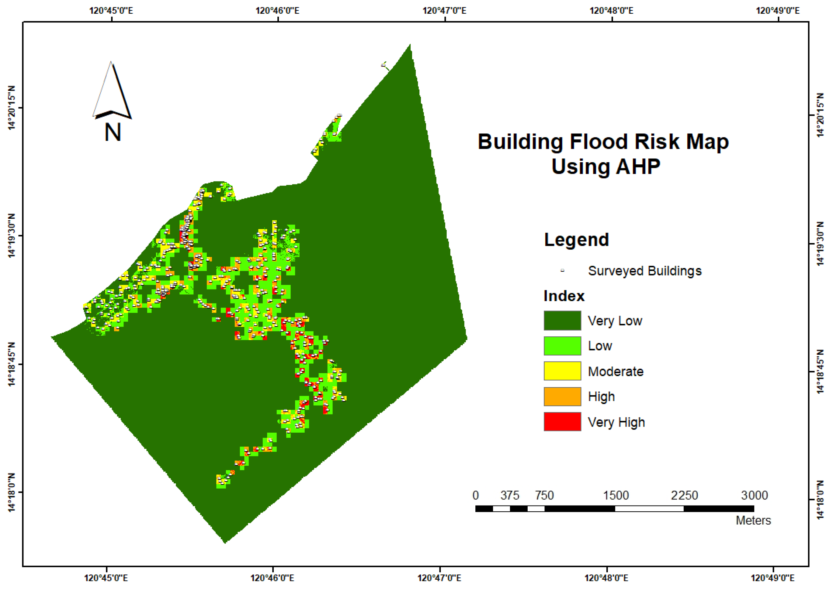
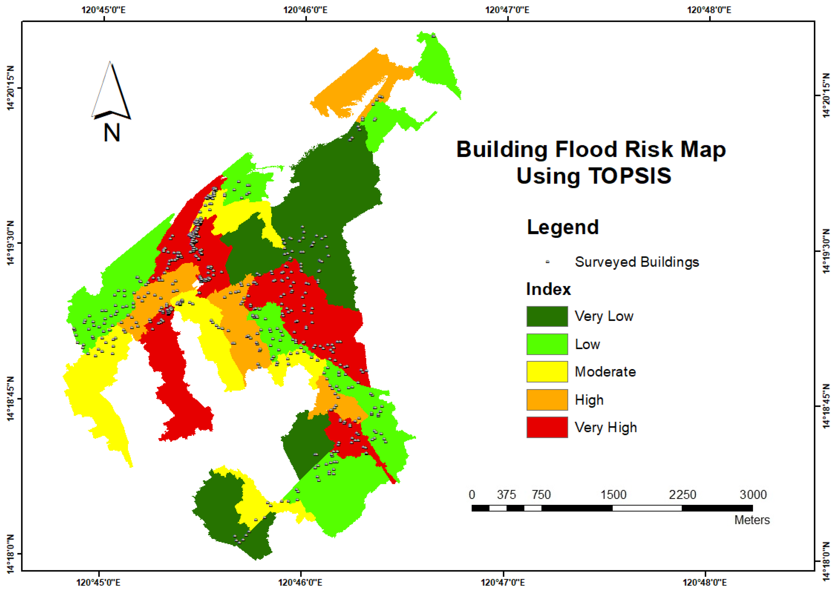
1) have been analyzed to develop the final building flood risk map. Flood risk is a triad of flood hazards, vulnerabilities, and exposure maps. Hence, they are combined and overlayed to get the final building flood risk map in GIS, considering their equal importance. By integrating the hazard, vulnerability, and exposure map utilizing AHP and TOPSIS methodologies, final building flood risk maps were generated for AHP and TOPSIS as shown in
Figure 11 and
Figure 12. The impact of floods on buildings is represented in maps by categorizing them from very-low to very high-risk levels. This can help determine the risk level for each building in the AOI.
3.1. Operational Differences between AHP and TOPSIS
The maps of the flood impact on the building using AHP and TOPSIS can differ due to their methodological differences. For instance, on a flood hazard map produced by the AHP, a building may be assigned a very low risk, yet on a map created by TOPSIS, the same building may be assigned a moderate risk category. This comparison highlights the variations in risk assessment using different multifaceted approaches to deal with flood risks. For comparison, each map was associated with 555 surveyed buildings for Naic and was classified by risk levels using the ‘spatial join’ tool to count the number of buildings in each category.
Both methods, AHP and TOPSIS, handle individual parameters differently. AHP relies on pairwise comparison to determine the weights of the parameters based on the hierarchical structure. The final maps are created using a weighted sum of individual parameters. Therefore, AHP methodology results are sensitive to the accuracy of the pairwise comparison and subjective to expert judgments. Due to the crisp nature of data and the hierarchical structure of this methodology, the building count in risk categories can show more variability based on the weights. Small changes in expert judgments can significantly lead to changes in the weights of parameters, which impact the results of AHP. On the other hand, TOPSIS provides a novel methodology compared to AHP, providing a ranking based on relative closeness to the ideal best solution. In TOPSIS, data is explicitly normalized to ensure compatibility across individual parameters in varying scales, after which AHP weights are applied. This methodology is sensitive to accurately determining the ideal best and ideal worst for each parameter and the weights assigned to the parameters. Further discussion of analysis of building shows how the operation difference in methods impacts the number of building counts in each risk level (very low–very high) is done in the
Section 3.2,
Section 3.3 and
Section 3.4 for hazard, vulnerability, and exposure maps respectively and also for the integrated building flood risk map in
Section 3.5.
3.2. Analysis of Building Count under Flood Vulnerability Map
In the AHP results, only 2 buildings fall under the very low category. AHP methodology combines individual maps using a weighted sum approach. Maps with cumulative weights exceeding 50% indicate a bias towards the moderate to high-risk area in building data. The results reflect this bias, with 229 buildings classified as very high risk, 178 buildings as high risk, and 138 buildings as moderate risk (see
Table 4). This distribution means that almost more than 90% of the buildings are moderate to very high-risk buildings according to the AHP method.
In TOPSIS, the catchment area was selected based on the distribution of survey data. As a result, zones that did not include survey data were excluded from the AOI, leaving only 41 zones for analysis. The results show that, out of 41 zones, 16 are very low to low-risk, with 158 structures falling into that risk category, suggesting that the buildings’ attributes determine each zone’s vulnerability. 8 out of 41 zones have 117 buildings classified in the moderate risk category, and 17 out of 41 are classified as high to very high risk, putting 280 of the examined buildings in that category. The result in the
Table 4 is neither biased towards very low nor very high values by the TOPSIS method. It is a straightforward ranking system based on the distance from the ideal solution, making it useful for precise decision-making scenarios.
3.3. Analysis of Building Count under Flood Exposure Map
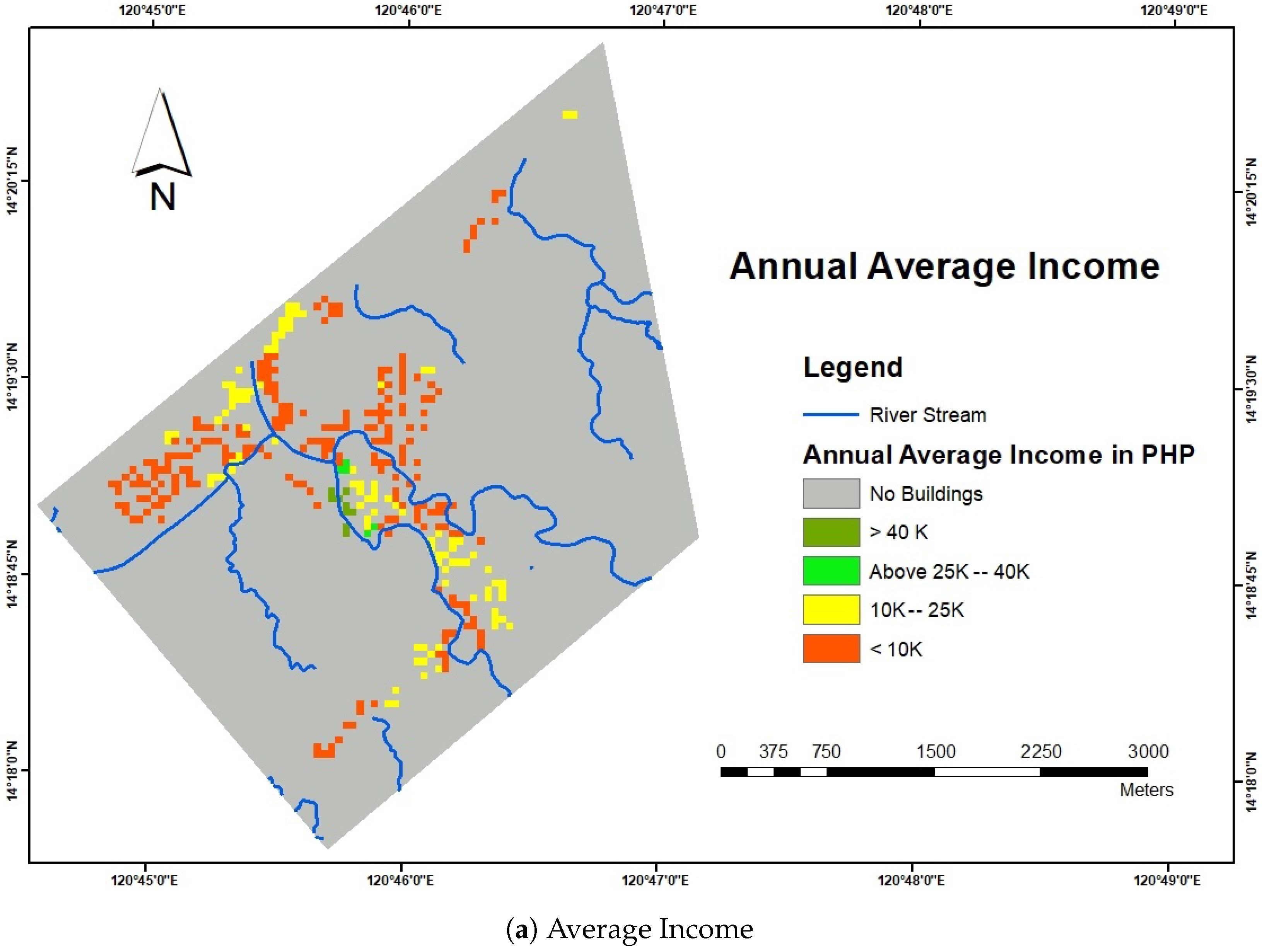
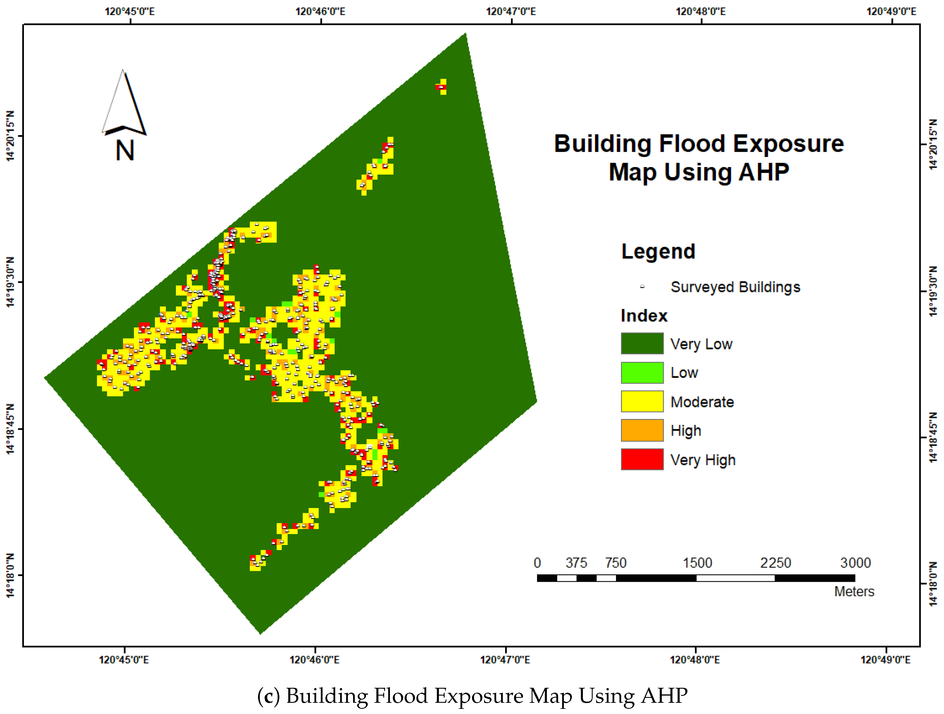
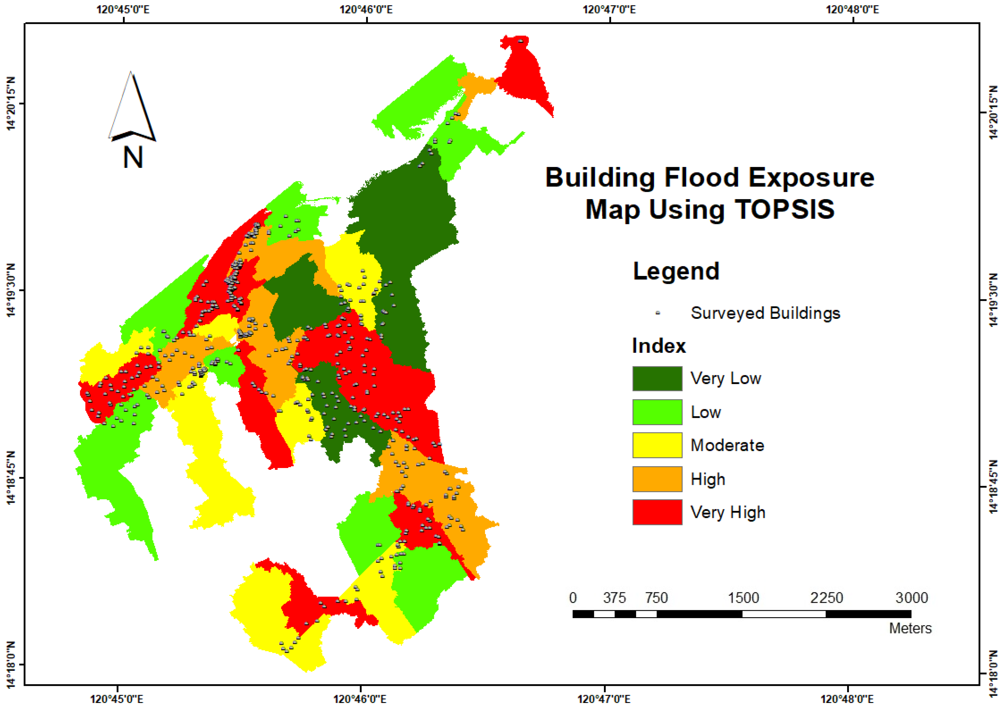
A comparable impact trend is evident across the individual parameters in the flood exposure and vulnerability maps. The formulation of the flood exposure map relies on attributes derived from surveyed building data.
Table 5 shows that only 4 buildings were classified as very low risk using AHP. However, in the TOPSIS method, 75 buildings are classified as low risk. In the AHP method, the maximum number of data points in building density and use of the building are in the high-risk category, and the weightage of these two categories is approximately 74%. This results in 257 buildings and 193 in very high and high-risk categories, respectively. In the TOPSIS methodology, as seen in
Table 5, 446 buildings under moderate to very high-risk zones can be observed, and 109 buildings are under very low to low risk. The TOPSIS methodology results do not represent the explicit data categories of individual maps as observed in AHP. However, the similarity in the results can be seen due to the influence of individual parameters. The exposure map shows that most of the buildings are under the moderate to very high-risk category in both methods because of the skewed data on the use of buildings and the number of buildings.
3.4. Analysis of Building Count under Flood Hazard Map
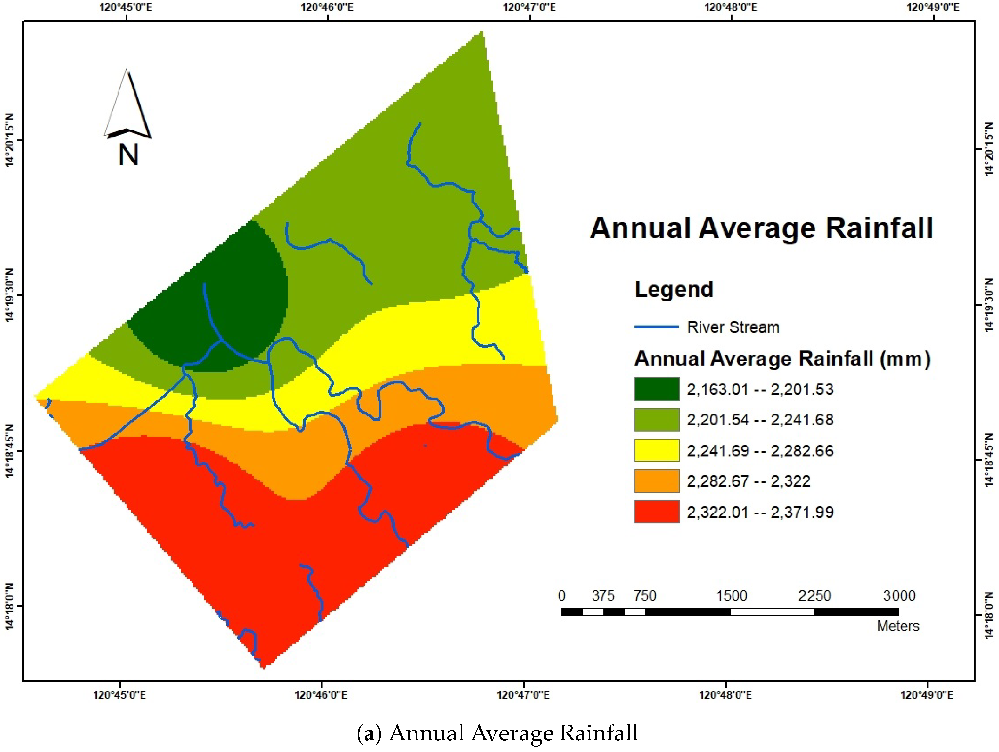
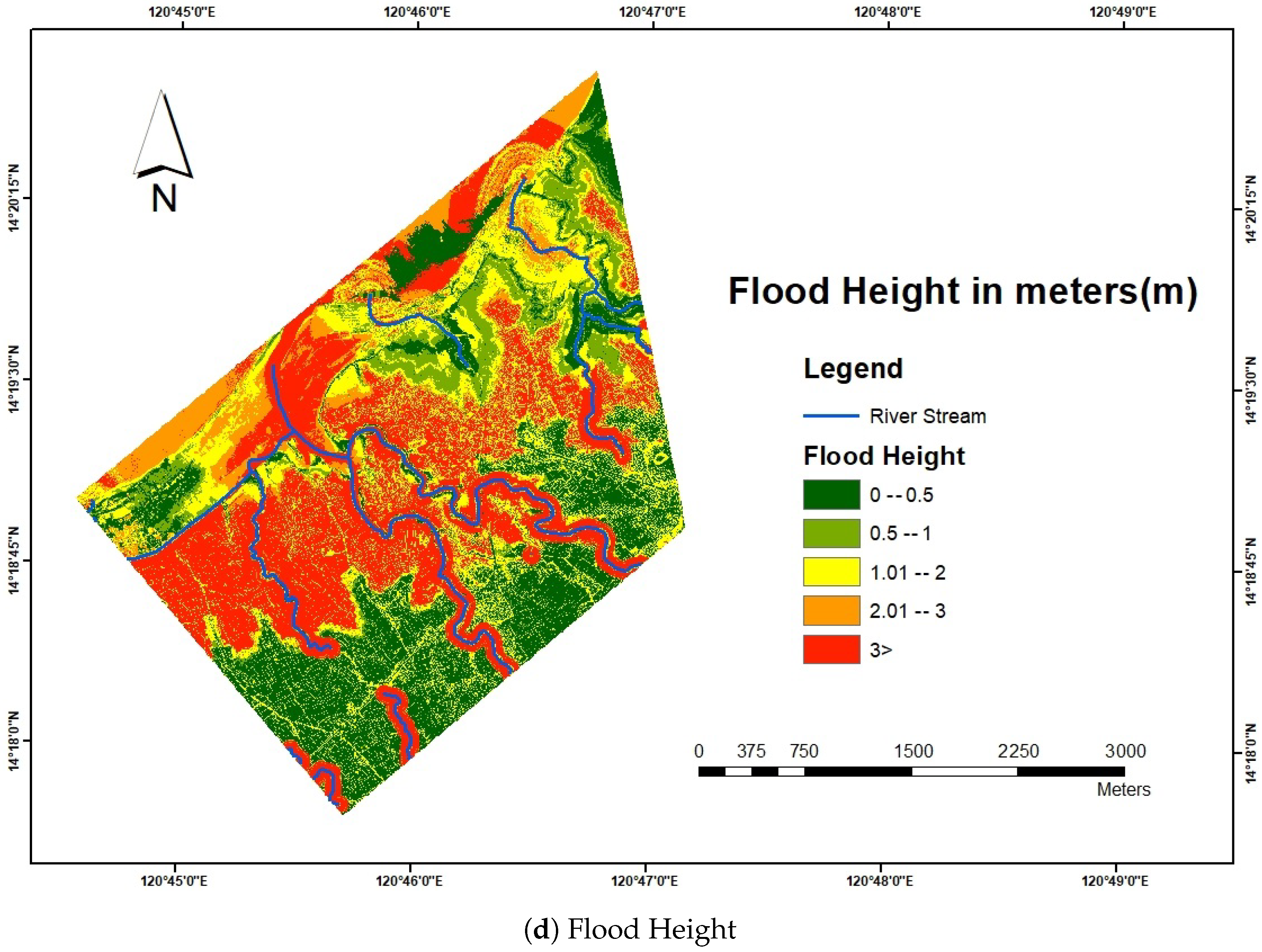
The buildings under the flood hazard map are analysed by including environmental factors such as annual average rainfall, flood height, slope, and elevation. The flood hazard map does not include a direct analysis of the building attributes as done in the vulnerability and exposure map. It analyses the parameters that affect the condition and vulnerability of buildings during and after flood events.
The flood hazard map using the AHP method shows that 101 buildings fall under the very low-risk category, 104 buildings are at low risk, 218 are at moderate risk, 101 are at high risk, and 31 are at very high risk by considering the geographical and topographical conditions around the buildings. More than 63% of the surveyed buildings are under moderate to very high-risk regions of the flood hazard map as presented in
Table 6. Only around 37% of the buildings are under the very low and low-risk category, with 101 buildings at very low risk and 104 buildings at low risk. By TOPSIS, around 74% of the buildings are classified as moderate to the very high-risk category, and the rest of the buildings with only 26% are in the very low to low-risk category. Since flood hazards focus on environmental factors, the risk categories are estimated using historical and geographical data.
3.5. Analysis of Building Count under Flood Risk Map
Finally, after integrating all three maps (hazard, vulnerability, exposure) in both methods, a flood risk map was generated as described by Equation (
1). The AHP method uses crisp data and the weightage of individual parameters to generate the final maps; the data available in individual maps having the highest weightage are more sampled towards moderate to very high-risk categories. This characteristic of data is directly reflected in the output of AHP, which makes 91.3% of the building under moderate to very high-risk categories, which can be alarming to the residents of the building and measure action towards it should be taken when a flood occurs. On the other hand, TOPSIS is better at handling such imbalanced data sets through its unique methodology, as seen in
Table 7 where 68% buildings are moderate to high risk. In the AHP method, only 4 buildings are classified as very low-risk. This may be due to the scarcity of buildings in this category on vulnerability and exposure maps. While there are 101 buildings in the very low-risk category on the flood hazard map, their structural integrity may not be robust, making them susceptible to minimal flood damage.
4. Discussion
The result presented in the study shows a notable difference in the risk categorization between AHP and TOPSIS using GIS. Similar to our study, other researchers have employed AHP, TOPSIS, and other MCDA methods to asses the flood risk and have noted the outcomes due to inherent methodological differences. For instance, a comparative analysis study by Pathan et al. [
21] examined both AHP and TOPSIS methodologies. This perspective leads to interpreting the outcomes of this study more effectively and shows that TOPSIS provides greater consistency with actual values. Numerous studies have evaluated flood risk using a single MCDM method. For instance, Huang et al. [
40] used AHP and discovered it was susceptible to expert opinion, causing variations in risk categorization. A similar observation was made in a study by Sarmiento et al. [
41] that AHP might magnify biases brought about by expert opinion, especially when the parameter weights are highly skewed. The results show that AHP often placed more buildings in the moderate to very high-risk categories, which is overall 91.3% buildings from survey data. It can be due to the subjective nature of pairwise comparisons and the hierarchical structure inherent in AHP.
On the other hand, TOPSIS normalizes data to ensure compatibility across different scales and ranks alternatives based on their distance from the ideal solution, which provides a more dispersed risk distribution. As observed in the study, 68% of buildings were categorized from moderate to high risk, which is lower than AHP but still indicative of significant risk. It means TOPSIS provides a more balanced distribution, affirming the results from the study by Ekmekcioğlu et al. [
42] and Nyimbili et al. [
43], where TOPSIS shows robustness in handling imbalanced datasets and is more suited for the implementation in a raster data structure as used in our study in a GIS environment. TOPSIS also offers a straightforward ranking based on relative closeness to the ideal solution.
5. Conclusions
Risk assessment of the buildings in the Naic region can assist in flood risk management and strategy planning, as buildings serve as a primary defence against flood disasters for a community. Also, the study aimed to identify the extent of buildings’ vulnerabilities and risk zones, which can help recommend practical measures to improve buildings’ strength on a priority basis before and after floods. Utilizing these methodologies can be the first step in understanding the impact of building attributes on flood risk and helping rural communities like Naic to be more resilient against flood hazards. Different methodologies presented in this study help understand the use case for qualitative risk assessment based on data and risk categorization. Both methods have pros and cons. The building count in both risk categories differs when using AHP and TOPSIS due to their fundamental methodological differences in handling the data to produce flood risk maps. As building FRA is determined using the MCDM technique with numerous variables such as assumptions, expert opinions, and conflicting parameters, no optimal solution exists as the output or the optimal solution based on the mentioned variables [
44].
Both methods consider the relative importance of each parameter for hazard, vulnerability, and exposure maps. In AHP, the weighted sum overlay is done with a crisp value for each parameter. On the other hand, the TOPSIS method involves normalizing the decision matrix of the parameter values, which helps bring the dataset into a uniform scale. Therefore, the effect of individual parameters is based on their importance rather than their true value, which is then used to create the weighted decision matrix. Even though TOPSIS involves more complex calculations during analysis, making it computationally complex and time-consuming compared to AHP, it is more suitable for datasets with different units. Calculating the relative closeness to the ideal best solution ensures that the parameters are analyzed and compared to the benchmark of optimal performance, promoting more reliable and effective decision-making. TOPSIS approach has methodological differences compared to AHP because it calculates the Euclidean distance of each parameter from the ideal best to the worst. TOPSIS can rank AOI in terms of zones or exact building locations by determining the relative closeness to the ideal best solution. Finally, the choice of the method depends on the particular need for risk assessment and the nature of input data. Moreover, both MCDM techniques analyzed in this study are reasonably basic, with a few computational processes that can be created and used in GIS. The results of both methods can be analyzed in a GIS environment. AHP and TOPSIS differed in GIS-based processing and analysis of a flood risk map after each parameter was selected and evaluated.
Despite the advantages of MCDM techniques, some inherent limitations are associated with them. Less data can severely affect the performance of outputs using the MCDM technique. The survey data of this study is only available for 555 buildings in the Naic region (AOI), but there are more than 10 thousand buildings in AOI that have yet to be surveyed. The results could be more accurate if a complete dataset for all parameters within the AOI were available rather than assuming the absence of buildings in certain areas.
In all 18 parameters, 4 were for hazard, 11 were for vulnerability, and 3 were for exposure, considering the environmental and socio-economic conditions with buildings’ attributes and how they affect the people of the Naic region. In future studies, more parameters, such as drainage density, soil type, and population density, can be considered. A sound drainage system helps reduce flood water accumulation in a region, so drainage density is essential to consider during flood risk analysis. The same goes for soil type in the context of water absorption and population density to check the number of people exposed in certain high-risk zones during floods. Future research should also explore geomorphological parameters that influence flood behavior and assess the role of drainage basins contributing to flood events, considering their size, shape, and hydrological characteristics.
Further research and comparison of MCDM techniques can be made on similar datasets to find suitable methods for building risk assessment such as Fuzzy Logic [
45], ELECTRE (ELimination and Choice Expressing Reality) [
46], PROMETHEE (Preference Ranking Organization Method for Enrichment Evaluations) [
47] and SAW (Simple Additive Weighting Method) [
48]. Fuzzy Logic has a wide variety to handle different datasets by providing various fuzzification methods. It includes a rule-based inference engine where custom rules can be designed based on the expert opinion and available dataset.
Overall, the MCDM technique is beneficial and efficient in buildings FRA as it provides decision-making with objectivity for multiple conflicting criteria and the participation of the researcher and experts. MCDM addresses the need for a more robust structure by avoiding inappropriate and fragile materials.
