Article

Application of Geotechnologies in the Characterization of Forage Palm Production Areas in the Brazilian Semiarid Region

by
Jacqueline Santos de Sousa
1,
Gledson Luiz Pontes de Almeida
1,
Héliton Pandorfi
1,
Marcos Vinícius da Silva
2,
Moemy Gomes de Moraes
3,*,
Abelardo Antônio de Assunção Montenegro
1,
Thieres George Freire da Silva
4,
Jhon Lennon Bezerra da Silva
5,
Henrique Fonseca Elias de Oliveira
5,
Gabriel Thales Barboza Marinho
1,
Beatriz Silva Santos
1,
Alex Souza Moraes
6,
Rafaela Julia de Lira Gouveia Ramos
1,
Geliane dos Santos Farias
1,
Alexson Pantaleão Machado de Carvalho
3 and
Marcio Mesquita
3
1
Department of Agricultural Engineering, Federal Rural University of Pernambuco, Recife 52171-900, PE, Brazil
2
Centro of Sciences Chapadinha, Department of Engineering Agricultural, Federal University of Maranhão, BR-222, Chapadinha 65500-000, MA, Brazil
3
Graduate Program in Agronomy, Federal University of Goiás (UFG), Campus Samambaia—UFG, Nova Veneza, Goiânia 74690-900, GO, Brazil
4
Agrometeorology Laboratory, Academic Unit of Serra Talhada (UAST), Federal Rural University of Pernambuco (UFRPE), Gregório Ferraz Nogueira Ave., Serra Talhada 56909-535, PE, Brazil
5
Cerrado Irrigation Graduate Program, Goiano Federal Institute, Campus Ceres, GO-154, Rural Zone, Ceres 76300-000, GO, Brazil
6
Department of Chemistry, Federal Rural University of Pernambuco, Recife 52171-900, PE, Brazil
*
Author to whom correspondence should be addressed.
AgriEngineering 2025, 7(6), 171; https://doi.org/10.3390/agriengineering7060171
Submission received: 5 April 2025 / Revised: 24 May 2025 / Accepted: 30 May 2025 / Published: 3 June 2025
(This article belongs to the Special Issue Recent Trends and Advances in Agricultural Engineering)

Abstract

Forage scarcity, intensified by climate variability and edaphoclimatic limitations in the Brazilian semiarid region, challenges regional livestock production. In this context, forage palm is a strategic alternative due to its drought resistance and environmental adaptability. However, little is known about the spatial and temporal dynamics of its cultivation. This study aimed to characterize the spatio-temporal dynamics of forage palm cultivation in Capoeiras-PE between 2019 and 2022 using remote sensing data and multitemporal analysis of the Normalized Difference Vegetation Index (NDVI), processed via Google Earth Engine. Experimental areas with Opuntia stricta (“Mexican Elephant Ear”) and Nopalea cochenillifera (“Miúda”) were monitored, with field validation and descriptive statistical analysis. NDVI values ranged from −0.27 to 0.93, influenced by rainfall, cultivar morphology, and seasonal conditions. The “Miúda” cultivar showed a lower coefficient of variation (CV%), indicating greater spectral stability, while “Orelha de Elefante Mexicana” was more sensitive to climate and management, showing a higher CV%. Land use and land cover (LULC) analysis indicated increased sparse vegetation and exposed soil, suggesting intensified anthropogenic activity in the Caatinga biome. Reclassified NDVI enabled spatial estimation of forage palm, despite sensor resolution and spectral similarity with other vegetation. The integrated use of satellite data, field validation, and geoprocessing tools proved effective for agricultural monitoring and territorial planning.

1. Introduction

The Brazilian semiarid region is characterized by scarce and irregular rainfall, high evapotranspiration, and frequent prolonged droughts [1,2,3]. These factors limit water availability and agricultural productivity, compromising food security and socioeconomic stability in the region [4,5]. At the center of this resilient ecosystem is the Caatinga biome, the only exclusively Brazilian seasonal tropical forest, composed predominantly of a forest of deciduous, xerophytic, and thorny species [6,7,8], which have suffered increasing anthropogenic influences, resulting in degradation and a decline in the quality of vegetation in the region [9,10].
In this challenging context, the variety known as “Orelha de Elefante Mexicana” refers to Opuntia stricta (Haw.) Haw., while “Miúda” corresponds to Nopalea cochenillifera (L.) Salm-Dyck. Both species belong to the Cactaceae family [6,11] and have played a strategic role as multifunctional forage resources, capable of meeting the nutritional and hydration needs of ruminants adapted to the climatic adversities of the Brazilian semiarid region [12,13,14]. As xerophytic species, these palms exhibit crassulacean acid metabolism (CAM), high water-use efficiency, adaptability to nutrient-poor soils, and salinity tolerance—traits that make them particularly well-suited for arid and semiarid environments [6,15,16]. Research indicates that their inclusion in cattle and goat diets enhances productivity while reducing the costs associated with water and energy supplementation [12,17,18].
Studies carried out in the Brazilian semiarid region have demonstrated the effectiveness of remote sensing in characterizing and monitoring the impacts of drought and soil degradation on local ecosystems, especially in response to climatic variations [9,19,20]. However, despite the relevance of this resource, mapping and systematic monitoring of forage palm cultivation areas are still incipient. In this scenario, the use of geotechnologies, such as the Google Earth Engine (GEE) platform, has been consolidated as a robust and strategic tool, as it enables the processing of large volumes of orbital data, allowing for the monitoring of plant biomass in semiarid regions [9,21]. High-resolution multispectral images, combined with spectral indices such as NDVI (Normalized Difference Vegetation Index), have proven effective in assessing the state, estimating productivity, and calculating the area and vigor of vegetation [22,23,24,25].
The integrated analysis of NDVI, pasture degradation monitoring, and land use and land cover (LULC) data is effective for understanding the spatial dynamics of areas of native vegetation, agriculture, and pasture in the Brazilian semiarid region as well as in other regions of the world, making it possible to identify the effects of anthropogenic activities on ecosystems, in the context of the expansion of agricultural activities [26,27]. According to Silva et al. [28], projections for the next 21 years indicate an increase in agropastoral areas and a reduction in native vegetation, showing a scenario of environmental and water vulnerability aggravated by climate change.
Many of the degraded areas in the semiarid region are the result of traditional land use practices, often marked by extensive grazing, inadequate management of conventional agriculture, and the adoption of inefficient soil cover techniques [29]. This occupation pattern contributes directly to the desertification process and the loss of the productive capacity of the soil [30,31]. Research shows that areas classified as degraded pastures still have productive potential. In their research, Bolfe et al. [31] identified around 28 million hectares in Brazil suitable for agricultural cultivation, without the need to suppress native vegetation. These data reinforce the importance of mapping these areas with a view to their recovery and sustainable use, which contributes to strengthening agriculture in the semiarid region and to policies aimed at combating desertification.
In view of the above, this research aimed to analyze the spatio-temporal dynamics of forage palm cover in the Brazilian semiarid region, using orbital data and geoprocessing techniques between the years 2019 and 2022. Specifically, it is proposed establishing representative NDVI intervals, based on the descriptive statistics of the clones “Orelha de Elefante Mexicana” (Opuntia stricta (Haw.) Haw.) and “Miúda” (Nopalea cochenillifera (L.) Salm-Dyck), grown in the municipality of Capoeiras in Agreste de Pernambuco—semiarid Brazil. It also aimed to apply supervised classification algorithms, in QGIS 3.22, to reclassify the NDVI data based on the intervals defined from the joint spectral average of the two forage palm cultivars. The range of values was adopted as a representative threshold for the crop in the region, making it possible to extrapolate the information to the municipal scale and characterize the spatial distribution of forage palm in the territory of Capoeiras. This approach contributes to integrating specific spectral analyses with regional applications, providing a promising alternative for agricultural monitoring in semiarid regions, thereby aiding agricultural planning and the formulation of public policies adapted to the region’s conditions.

2. Materials and Methods

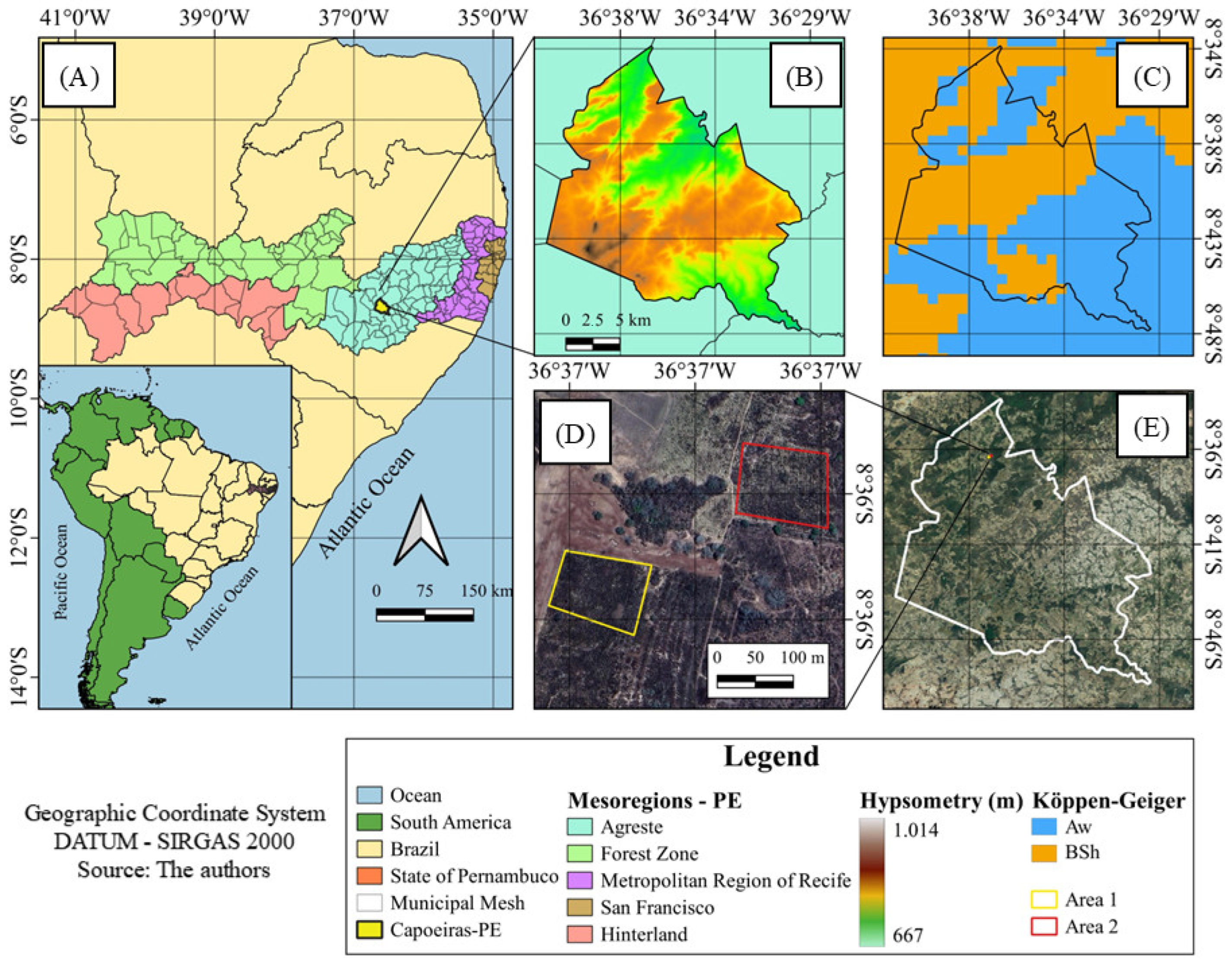
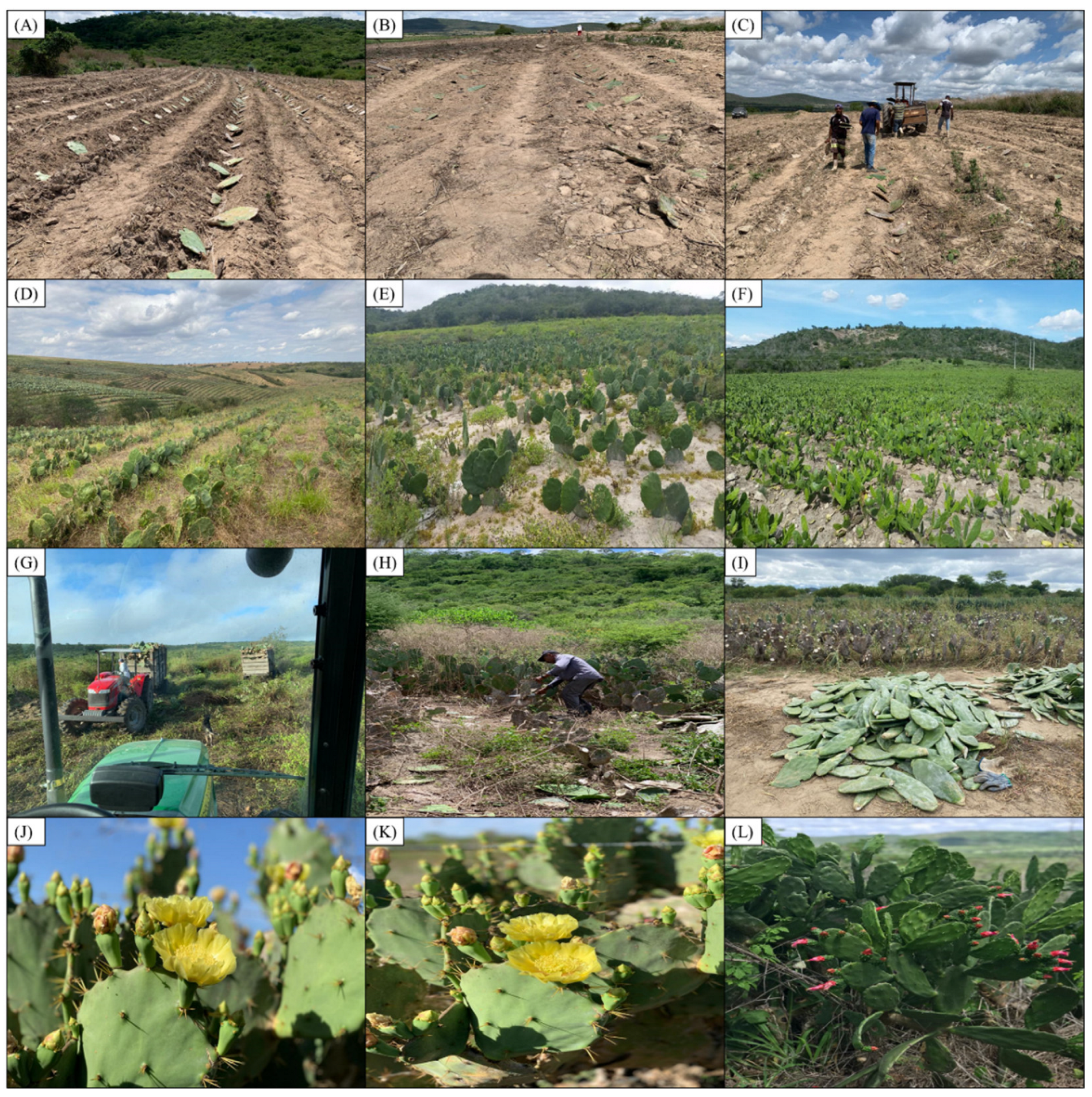
2.1. Study Area and Characterization of Palm Clones

The study was carried out in the municipality of Capoeiras, located in the Agreste mesoregion of the state of Pernambuco (PE), Brazil (Figure 1). The region is located between the parallels 08°35′ S and 08°46′ S and the meridians 36°30′ W and 36°42′ W, with an average altitude of 763 m (Figure 1). According to the Köppen classification, the region’s climate is located in a transition area of the “Aw” type—tropical climate with dry winters and “BSh”—hot semiarid region [32,33]. According to the climatological normal data from 1981 to 2010, provided by the National Institute of Meteorology (INMET data available at: https://portal.inmet.gov.br/normais, accessed on 24 March 2023), the average annual air temperature in the region is 22.80 °C, with a minimum of 18.70 °C and a maximum of 29.30 °C; the average annual rainfall in the region is 591 mm year−1.
Two experimental areas were analyzed (Area 1 and Area 2), both with approximately 1 hectare each, destined for the cultivation of forage palm. Area 1 was planted in September 2015 with the “Orelha de Elefante Mexicana” clone (Opuntia stricta (Haw,) Haw.), which was 7 years old at the time of data collection. Area 2, on the other hand, was planted in September 2016 with the 6-year-old “Miúda” clone (Nopalea cochenillifera (L.) Salm-Dyck). Both crops were grown under rainfed conditions using plant spacing of 1.4 × 0.6 m for “Orelha de Elefante Mexicana” and 1.2 × 0.2 m between plants of the “Miúda” genus. It should be noted that the two palm genera used in this research are resistant to the carmine mealybug (Dactylopius coccus Costa) [34,35].

2.2. Normalized Difference Vegetation Index Processed in Google Earth Engine

The Normalized Difference Vegetation Index (NDVI) was calculated using the ratio between the difference in the reflectance of the near infrared (rb VIII) and red (rb IV) and the sum of them, according to Equation (1) [36,37], where rb VIII and rb IV correspond to reflective bands 8 and 4 of the Sentinel-2 MSI sensor, respectively.
NDVI = r b   VIII   -   r b   IV r b   VIII   + r b   IV
The Normalized Difference Vegetation Index (NDVI) was processed on the Google Earth Engine (GEE) platform (https://earthengine.google.com/, accessed on 18 January 2023), using the JavaScript programming language. The months of October and November were observed, which correspond to the dry season in the study area. The images were obtained from the ee.ImageCollection(COPERNICUS/S2_SR) collection, made up of surface reflectance products generated by the Sentinel-2 satellite, which has 10 m spatial resolution and surface reflectance products from 28 March 2017 to the present day. For the municipality of Capoeiras (PE), images were processed from 2019 to 2022, generating NDVI compositions for the municipal territory in the months studied. The maps were produced in Quantum GIS (QGIS) software version 3.22.

2.3. Climate Characterization via the National Meteorological Institute

To characterize the local climatic conditions, air temperature (°C) and precipitation (mm) data were analyzed from the meteorological station of the Brazilian National Institute of Meteorology (INMET), located near the municipality of Capoeiras, Pernambuco (PE). The data cover the period from 2018 to 2022, with annual and monthly records limited to the months of October and November. The climatic analysis contributes to understanding the seasonal dynamics of vegetation and its spectral responses over time [37].
The months of October and November were chosen because they represent the driest period in the Agreste region of Pernambuco. During this time, most plant species exhibit reduced photosynthetic activity, loss of vigor, and declining vegetation indices as a result of senescence or leaf loss [38,39,40]. In contrast, xerophytic species such as forage cactus (Opuntia stricta (Haw.) and Nopalea cochenillifera (L.) Salm-Dyck) maintain high levels of chlorophyll and green biomass even under severe water stress, displaying distinct spectral behavior compared to other vegetation types [7].

2.4. Descriptive Statistics

The NDVI images were statistically analyzed using QGIS software (version 3.22), focusing on the spectral characterization of the two forage palm genotypes—Nopalea cochenillifera Salm-Dyck (“Miúda”) and Opuntia stricta (Haw.) (“Orelha de Elefante Mexicana”). Descriptive measures such as mean, median, standard deviation, variance, and coefficient of variation (CV, %) were calculated for each polygon sampled. Then, the general average of the values between the polygons of each genotype was obtained, making it possible to identify the average spectral signature associated with each type of palm during the period analyzed [38].
To assess intra-species spectral consistency and uniformity, the coefficient of variation was used as an indicator of homogeneity. CV values were interpreted according to Warrick and Nielsen’s classification [41], and were considered low when CV < 12%, medium between 12% and 24%, and high when CV ≥ 24%. This approach made it possible to analyze the internal variability of the spectral responses of the genotypes studied, making a robust contribution to defining their typical spectral signatures during the dry season.

2.5. Land Use and Land Cover Classification via MapBiomas Brazil

The analysis of land cover and land use was based on data from Collection 8.0 of the MapBiomas platform, available at: https://plataforma.brasil.mapbiomas.org/, accessed on 23 January 2023. The platform offers standardized time series of land use and land cover data, generated from mosaics of Landsat images and automatic classifications using algorithms validated for the Brazilian context.
In this study, the Level 1 legend classes most representative of the semiarid region were used: Forest (arboreal caatinga); Non-forest Natural Formation (shrubby caatinga)’ Agriculture; Non-vegetated Area; and Water Bodies. According to the Algorithm Theoretical Basis Document data, available at: https://brasil.mapbiomas.org/analise-de-acuracia/, accessed on 14 August 2023, the “Non-Vegetated Area” class includes urban areas and exposed soils.
The raster files were processed in QGIS 3.22, using the GRASS GIS 7 “r.report” plugin, to quantify the areas occupied by each class from 2019 to 2022. Four maps were produced, one for each year analyzed in the research, in QGIS version 3.22.

2.6. Identification and Measurement of Forage Palm Clone Cultivation Areas

The identification of areas under cultivation of forage palm clones (Opuntia stricta (Haw.) and Nopalea cochenillifera Salm-Dyck) was carried out in two complementary methodological stages. In the first, two reference areas previously recognized in the field were defined: area 1, with the cultivation of Opuntia stricta (“Orelha de Elefante Mexicana”), and area 2, characterized by the presence of Nopalea cochenillifera (“Miúda”). In these areas, the Normalized Difference Vegetation Index (NDVI) values were collected from images taken in October and November—the period of most severe drought in the region, when drought-adapted vegetation such as Cactaceae tends to maintain greater photosynthetic activity.
The spectral information obtained made it possible to estimate the representative NDVI range associated with the forage palm crops in the sampling areas (Areas 1 and 2), taking into account the consistency of the data between the different genotypes observed, which returned the general average between both crops as the representative threshold. The spectral range found was the basis for the subsequent thematic classification stage.
In the second stage, the spectral characterization was extrapolated to the entire territory of the municipality of Capoeiras (PE), using the “Reclassify by Table” tool available in the QGIS software (version 3.22). The NDVI images were reclassified into three distinct intervals: (i) values lower than those of the reference areas, associated with sparse vegetation or degradation; (ii) values compatible with palm plantations, according to the spectral interval identified; and (iii) higher values, indicative of denser vegetation.
The reclassified images were then converted from raster to vector format, making it possible to quantify the classified areas. The final extent, expressed in hectares, corresponds to the regions whose spectral signature resembles that attributed to forage palm, enabling a spatial analysis of its distribution in the municipality and contributing to an understanding of agricultural dynamics in the Brazilian semiarid region.

3. Results

3.1. Study Area

The on-site visits carried out between 2016 and 2021 made it possible to record the different phenological stages of the forage palm crops at the sites sampled. Figure 2A–C correspond to the period when the cultivars were first planted, with a predominance of exposed soil between the rows. Figure 2D–F show areas three years after planting, with vegetation in the development stage and no recent management. Figure 2G–I refer to the harvest period, recorded between the end of 2020 and the beginning of 2021.
Field visits helped to demarcate the areas cultivated with forage palm, as well as to identify the predominant genotypes—“Orelha de Elefante Mexicana” and “Miúda”. The visual records obtained during the on-site monitoring show different stages of cultivation, including areas with exposed soil, developing vegetation, and plots under harvest. Although the start of planting precedes the period of acquisition of the images used in this study, the photographs help with the interpretation of spectral data, especially with regard to NDVI variability, since the presence of exposed soil can directly influence the observed values [42], especially in the first years analyzed [38].

3.2. Characterization of Forage Palm Species

Table 1 is a comparative table between the forage palm genotypes identified in the field: “Orelha de Elefante Mexicana” and “Miúda”. The distinction was necessary considering that the two species have different morphological characteristics, water requirements, and productivity patterns, factors that can directly influence the interpretation of spectral data and the dynamics of the vegetation observed over the study period.
As shown in Table 1, “Miúda” has a higher water content in the cladodes (88–92%) and a faster multiplication cycle [43,44,46], as well as being more adapted to environments with high water restriction, which can favor more immediate responses to environmental conditions and positively influence vegetation indices [7]. On the other hand, “Orelha de Elefante Mexicana”, despite requiring more water, stands out for its greater biomass accumulation (12–18 t DM/ha/year) and high energy value, characteristics that justify its maintenance in areas with greater water support [11,43]. These distinctions are important for interpreting the spectral signatures of the palm cultivars studied [47].

3.3. NDVI Descriptive Statistics for “Orelha de Elefante Mexicana” and “Miúda” Palms

The descriptive statistics of the NDVI (Normalized Difference Vegetation Index) values—a dimensionless index—for the forage palm cultivars Nopalea cochenillifera (L.) Salm-Dyck (“Miúda”) and Opuntia stricta (Haw.) Haw. (“Orelha de Elefante Mexicana”), in the municipality of Capoeiras, Pernambuco, Brazil (Table 2). The table shows the minimum and maximum NDVI values, mean, standard deviation (SD), and coefficient of variation (CV, in %) for each cultivar during the dry season (October and November), from 2019 to 2022. NDVI is a widely used indicator for monitoring vegetation, ranging from −1 to +1, with higher values indicating greater photosynthetic activity.
Analysis of the average NDVI values obtained for the two forage palm cultivars between 2019 and 2022 revealed distinct spectral response patterns over time. The “Miúda” palm showed more stable and slightly higher average values in the months of October and November, especially in 2020 and 2022, when the NDVI peaks reached 0.42 and 0.50, respectively. “Orelha de Elefante Mexicana”, on the other hand, showed greater variability, with more significant fluctuations between the years, reaching its highest average value (0.53) in November 2020 and showing its lowest indices in 2021. The significant reduction in values in 2021 can be attributed to the harvest carried out at the end of 2020 and the subsequent replanting, which resulted in high soil exposure, negatively interfering with the spectral response recorded in the images [38].

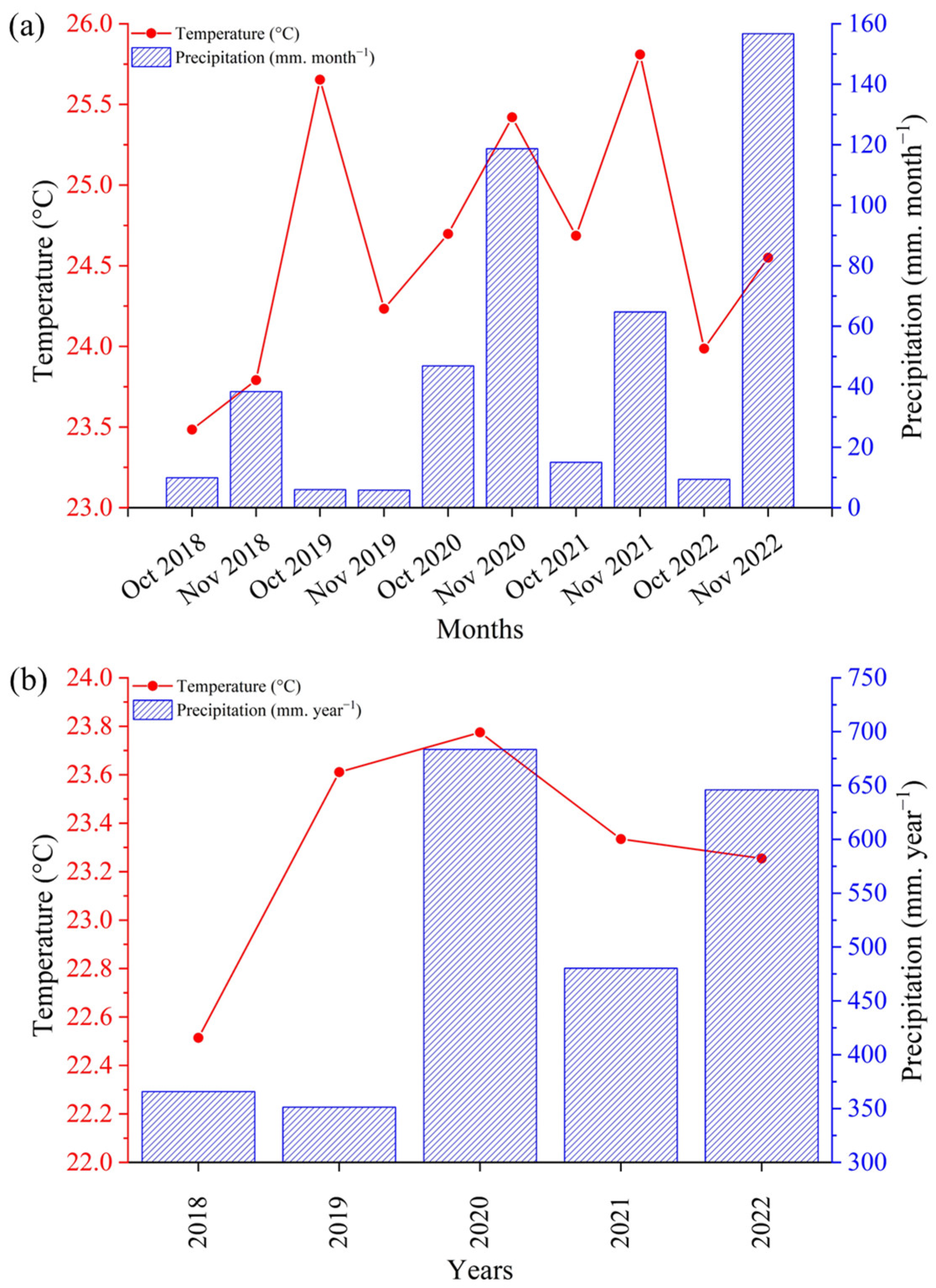
3.4. Temperature and Rainfall Data

The records of average air temperature (°C) and accumulated rainfall for the months of October and November (A), as well as the average annual temperature and total annual rainfall (B), for the period from 2018 to 2022 are illustrated in Figure 3. The data were obtained from the meteorological station of the National Institute of Meteorology, available at: https://mapas.inmet.gov.br, accessed on 23 March 2023, and serve as the basis for the climatic characterization of the study area. The year 2018 was included with the aim of identifying any residual influences of pre-existing humidity or drought on the crop cycle observed from 2019 onwards, the start of the study period.
The climate data showed the predominance of a typical semiarid climate throughout the period analyzed, with significant inter-annual variability in rainfall. The year 2020 had the highest volume of rainfall during the research period, associated with a subtle increase in the average annual temperature, which coincided with the highest average NDVI values recorded for both cultivars in the year in question. In contrast, 2021 was characterized by a reduction in rainfall and thermal stability. In 2022, there was a partial recovery in rainfall and an improvement in spectral patterns (Table 2). Notably, October and November 2020 and 2022 showed the highest rainfall volumes, reaching around 120 mm and 150 mm, respectively, indicating episodes of atypical rainfall during this period [3,4]. This variability reinforces the importance of considering isolated rainfall events in NDVI responses [7,47].

3.5. NDVI Analysis

Figure 4 shows the spatial and temporal variation of the Normalized Difference Vegetation Index (NDVI) in the municipality of Capoeiras-PE, in the months of October and November between the years 2019 and 2022, which made it possible to assess seasonal vegetation fluctuations on a municipal scale.
The NDVI values over the years analyzed ranged from −0.27 to 0.93. The month of November 2019 showed the lowest vegetation indices, while the highest values were recorded in 2022, directly reflecting the climatic conditions of the period [47]. The patterns suggest a vegetation response to the occurrence of previous rainfall events, especially when considering the time needed for plant biomass to manifest noticeable spectral changes in orbital data [28,47]. The assessment on a municipal scale revealed large areas with a high NDVI after the rainy periods, showing the regeneration of vegetation cover in different parts of the territory. The NDVI result is not limited exclusively to agricultural crops, but includes natural formations, herbaceous plants, and opportunistic grasses that quickly re-establish themselves in the seasonal conditions of the semiarid region [28,48].

3.6. NDVI Reclassification

Based on the average values obtained in the statistical analyses of the spectral responses of the two forage palm cultivars (“Miúda” and “Orelha de Elefante Mexicana”), the NDVI images were reclassified to identify areas with potential for the species in the municipality of Capoeiras-PE (Figure 5). The methodology considered the common average range between the two cultivars. Thus, a representative range of the typical spectral behavior of forage palm was defined and used as the basis for reclassifying the NDVI images in the different years and months analyzed.
The data obtained in Figure 5 show significant variations in the areas identified as potential for palm over the period 2019 to 2022. The estimated values for the months of October ranged from 1214.79 ha (2022) to 2027.54 ha (2020), while for the months of November the values ranged from 751.66 ha (2022) to 1577.04 ha (2020). The largest area was recorded in October 2020, and the smallest in November 2022, indicating seasonal and inter-annual variations in environmental conditions and vegetation response, especially influenced by the region’s water regime.

3.7. Land Use and Occupation (LULC)

The analysis of land use and land cover (LULC) from 2019 to 2022 in the municipality of Capoeiras-PE made it possible to identify the main classes that make up the municipality’s landscape, highlighting patterns of permanence and change in occupied areas [37]. The main classes observed were: Forest; Non-forest Natural Formation; Agriculture; Non-vegetated Area; and Water Bodies. Figure 6 shows the spatial distribution of these classes over the four years analyzed.
It was observed that the Agricultural class remained the most representative in terms of area throughout the analyzed period, ranging from 22,151.04 hectares (ha) in 2019 to 22,196.89 ha in 2022, with minor fluctuations in the intermediate years. The Forest class exhibited a slight reduction over the four years, decreasing from 11,302.87 ha in 2019 to 11,218.78 ha in 2022, which may be associated with anthropogenic pressures, such as agricultural expansion or inadequate land management. The Non-Vegetated Area class showed a gradual increase, from 206.59 ha in 2019 to 235.71 ha in 2022, indicating potential processes of degradation, vegetation suppression, or intensified land use. The Water Body class also experienced a small increase at the end of the period, rising from 75.86 ha to 84.88 ha, possibly related to greater water accumulation in years with higher rainfall. Finally, the Non-Forest Natural Formation class remained practically stable, with values close to 7 ha over the four years.

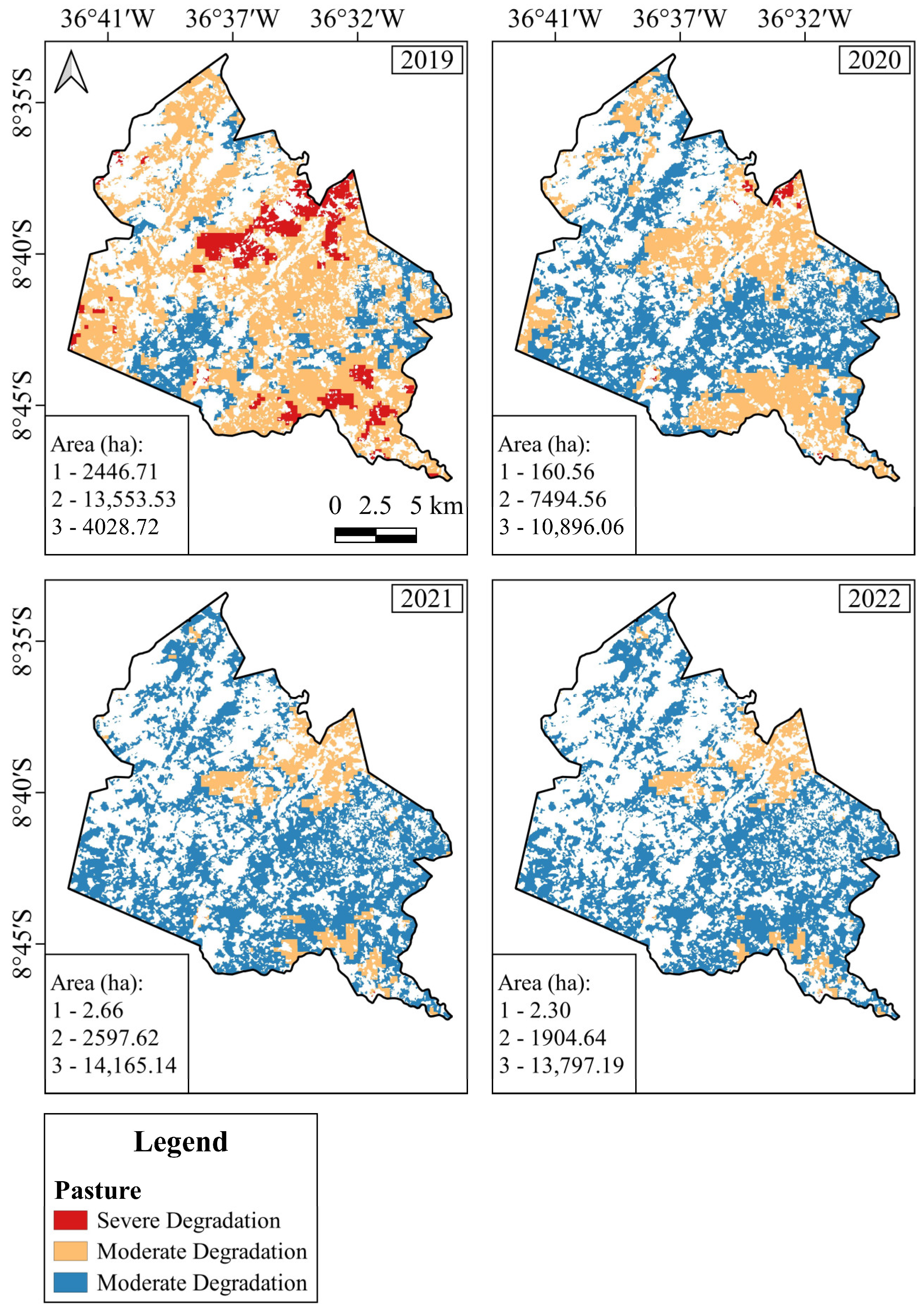
3.8. Pasture Degradation

Figure 7 shows the evolution of the degree of degradation in the study area, in relation to the pasture areas, between 2019 and 2022. Degradation was categorized into three levels: severe, moderate, and no degradation, represented by the colors red, yellow, and blue, respectively.
The analysis of pasture degradation data revealed a clear trend of improvement in the condition of forage vegetation over the four years analyzed. In 2019, the highest number of severely degraded (2446.71 ha) and moderately degraded (13,553.53 ha) areas was observed, totaling approximately 16,000 hectares at some level of degradation. From 2020 onwards, these areas were significantly reduced, with the highlight being 2021, which saw only 2.66 ha of severely degraded pastures and 2597.62 ha moderately degraded. However, the area classified as non-degraded grew progressively, reaching 14,165.14 ha in 2021 and remaining at similar levels in 2022 (13,797.19 ha), which shows a significant recovery in the vegetation cover of these areas.

4. Discussion

The multitemporal analysis of NDVI between 2019 and 2022 revealed significant patterns in the spectral response of forage palm to environmental conditions and agricultural management practices in the municipality of Capoeiras-PE (Table 2). The combination of remote sensing data and field validation made it possible to clearly distinguish between the cultivated genotypes—Opuntia stricta (“Orelha de Elefante Mexicana”) and Nopalea cochenillifera (“Miúda”)—and to identify structural and phenological variations that directly influence the spectral values recorded (Table 1).
Opuntia stricta stands out for its high biomass production, with potential yields of over 250 Mg ha−1 of fresh green matter under ideal conditions [44,46]. It has high digestibility (60–70%), 10–15% dry matter (DM), and soluble carbohydrates above 50% of DM [11].
Nopalea cochenillifera has slightly higher levels of crude protein (5–7%) and excellent digestibility (>65%), with low neutral detergent fiber (NDF <30%), making it especially suitable for small ruminants [43]. Both varieties are fundamental in ruminant diets in the semiarid due to their resilience and high palatability [6,11,43].
Studies show that Opuntia and Nopalea do not deplete the soil, but contribute to its improvement by increasing organic carbon and microbial activity, due to perennial cover and minimal disturbance [11,43,44].
Annual NDVI variability was strongly correlated with rainfall patterns, highlighting the high sensitivity of forage vegetation to water availability [47]. In 2020, the occurrence of atypical rainfall in traditionally dry months, such as October and November, promoted significant peaks in NDVI, especially in areas with herbaceous and forage cover (Figure 4). However, it is important to highlight the non-immediate behavior of forage palm in the face of rainfall events [47]. The succulent morphology and metabolism adapted to aridity require a time interval for the conversion of moisture into biomass, which justifies the delay observed between rainfall events and increases in index values [11,15].
In addition to climatic influence, agricultural management played a decisive role in spectral dynamics. Harvesting at the end of 2020 resulted in a sharp drop in NDVI values, which had an impact on the results for the following year, 2021, when the vegetation was in the initial stages of regrowth [7,38]. The effect was more evident in the “Orelha de Elefante Mexicana” cultivar, which showed greater spectral variability (CV, %), demonstrating high sensitivity to climatic variations and the phenological stage. In contrast, the “Miúda” cultivar showed a more stable spectral response, even under moderately dry conditions, which can be attributed to its denser and more compact morphological structure, which favors the maintenance of leaf biomass and faster vegetative multiplication [15,44].
Another relevant factor in the interpretation of NDVI was the presence of opportunistic vegetation in years of high humidity (Figure 2). The reclassified images from 2020 and 2021 indicated an expansion of areas with a spectral signature similar to that of palm, possibly influenced by the growth of native herbaceous plants and shrubs. According to Barbosa et. al. [49], the increase in rainfall contributes to an increase in the NDVI of the Caatinga ecosystem, but other factors can contribute individually to triggering the processes of reducing and increasing this index. Figure 2 shows the presence of vegetation opportunities developing between the cultivation lines of the palm genera studied. Interspecific competition, typical of semiarid environments shortly after rainy events, tends to reduce the spectral dominance of various types of vegetation, including cacti, making it difficult to differentiate the crop based on spectral indices alone. In addition, the overlapping of vegetation responses may have led to an overestimation of the areas cultivated with palm in some sections of the analysis.
Although the year 2022 saw significant rainfall, especially in the month of November, analysis of the reclassified NDVI (Figure 5) revealed a reduction in the area occupied by high values of the index. This apparent discrepancy can be explained by two main factors: the vegetation’s delayed response to accumulated moisture and the saturation of the index in the face of intense, one-off hydrological events.
During the dry season, opportunistic vegetation showed reduced physiological activity, reflecting low NDVI values. Even with the return of the rains, the time needed for metabolic reactivation, leaf growth, and increased biomass meant that the spectral effects were only fully perceptible in the following months and were not significantly captured in the time frame analyzed. As analyzed by Zhang et al. [50], research indicates that, in semiarid ecosystems, moderately prolonged dry intervals between rainfall events can promote plant production by allowing better infiltration of water into the soil and reducing losses due to surface evaporation. However, excessively long intervals can lead to soil moisture exhaustion, compromising plant growth.
In addition, NDVI has limitations in areas with dense canopies or under rapid increases in humidity, which can lead to saturated values and mask relevant structural variations in the vegetation. As observed by Li et al. [51], when investigating the response and sensitivity of global vegetation to water stress with different NDVI products, a low consistency between the indices was identified, implying that saturation generates substantial uncertainties in the representation of vegetation cover. Therefore, the combination of concentrated rainfall over a short period and the subsequent delayed physiological response of vegetation contribute to the observed reduction in areas with high reclassified NDVI values in 2022, despite the overall increase in annual rainfall.
The application of reclassified NDVI proved to be effective in estimating the dynamics of vegetation cover on a municipal scale, especially when associated with climate data and on-site validation. However, it should be noted that the spectral similarity between the genotypes evaluated limits the ability to distinguish between cultivars using only multispectral optical sensors. To overcome this limitation, hyperspectral sensors or sensors with higher spatial and temporal resolution—capable of capturing specific structural and pigmentary subtleties of the cultivars—would be necessary, as identified in Andrade et al.’s [38] research.
The analysis of land use and land cover classes (LULC) in the municipality of Capoeiras-PE shows that farming remains the predominant activity (Figure 6), confirming the productive vocation of the territory, where the cultivation of species adapted to the semiarid climate—such as forage palm—and extensive livestock farming stand out. The relative stability in agricultural and pasture areas observed over the period analyzed suggests a consolidated use of the land, albeit subject to seasonal and climatic fluctuations.
The subtle variations in forest areas, with a downward trend, can be attributed to gradual processes of replacement by pasture, forage crops, or anthropogenic use, which reinforces the need for continuous monitoring, especially given the protective function of native vegetation on soil and water resources [52]. However, the slight increase in the area of water bodies in 2022 may reflect a higher incidence of rainfall in this period, which is also indicated by the climate data, reinforcing the interaction between seasonality and water availability.
However, the Unvegetated Area increased by approximately 14% between 2019 and 2022—from 206.59 ha to 235.71 ha. This growth deserves attention, as it may be related to multiple factors, such as intensification of land use, removal of vegetation cover, agricultural practices without conservation management, extreme weather events, or even erosion processes. These changes have a direct impact on soil stability and local hydrological dynamics, requiring continuous monitoring, since the alteration directly interferes with the spectral patterns captured by remote sensing and may represent signs of environmental degradation [7,53].
Regarding pasture areas (Figure 7), there was a significant transformation between 2019 and 2022, especially with regard to the degradation of these areas. In 2019, under the strong influence of a year with low rainfall, pastures in a state of moderate (13,553.53 ha) and severe (2446.71 ha) degradation predominated, while non-degraded areas occupied only 4028.72 ha. This scenario may be related to the excessive exposure of the soil, the low resilience of some forage species in the face of the adverse conditions of the semiarid region, as well as the intensification of forage harvesting and forage palm—especially cultivars such as Opuntia stricta (Haw.), used as a source of water and food for the herd in critical periods.
In the following years, marked by more regular rainfall, there was a substantial recovery of herbaceous and opportunistic vegetation, which was reflected in the expansion of areas classified as non-degraded: from 10,896.06 ha in 2020 to 13,797.19 ha in 2022. At the same time, severe degradation was practically eliminated (reduced to 2.30 ha in 2022). This pattern suggests a direct response of vegetation cover to improved water conditions, favoring the development of native pastures and vegetation adapted to the semiarid climate.
In addition, this regeneration contributes indirectly to the maintenance of areas cultivated with forage palm, since the greater availability of biomass reduces the pressure on perennial crops during periods of scarcity. This dynamic reveals a productive balance between temporary and permanent forage, with important implications for the resilience of the region’s agricultural systems [54].
The drop in NDVI indices and the increase in degradation in 2019 illustrate the impacts of water scarcity on forage productivity and vegetation cover as a whole. In contrast, the following years, especially 2022, showed higher NDVI values, reflecting not only the resilience of the pastures but also the intense competition between native vegetation and forage palm crops and the effectiveness of management strategies combined with a more resilient regime.
These results highlight the importance of integrated analysis between land use and land cover data and climate variables in understanding local agricultural dynamics. In a territory with a strong dependence on agriculture and livestock, such as Capoeiras, this type of monitoring is pertinent to guide public policies and management practices that guarantee the sustainability of production in the face of climatic variations that directly affect the performance of strategic and alternative crops such as forage palm crops.

5. Conclusions

This research demonstrated the effectiveness of using orbital data and geoprocessing techniques in the spatio-temporal analysis of forage palm cover in the Brazilian semiarid region, with a focus on the municipality of Capoeiras, in Pernambuco. Spectral analysis of the Opuntia stricta (Haw.) and Nopalea cochenillifera (L.) Salm-Dyck genotypes revealed distinct patterns of response to climatic conditions and agricultural management, reflecting their importance in the sustainability of regional livestock farming. By statistically analyzing the NDVI values in the cultivated areas, it was possible to identify a spectral band representative of forage palm cultivation during the period studied, and to apply this band as a reclassification threshold to estimate its spatial distribution in the municipality. This approach highlighted the persistence and adaptability of palm to the seasonal climatic variations typical of the semiarid region, highlighting its relevance as an agricultural strategy for food security and drought resistance.
However, the spectral distinction between the two genotypes analyzed presented significant limitations, attributed mainly to the low spatial resolution of the orbital images used and the insufficient temporal frequency to capture specific phenological variations or management events (such as cutting and regrowth). The overlapping spectral responses between the cultivars and the presence of spontaneous vegetation in the surroundings also made it difficult to separate the classes more precisely, partially compromising the accuracy of the supervised classifications.
Despite these limitations, the methodology adopted proved to be effective as an initial proposal for mapping forage palm on a municipal scale, integrating specific spectral analyses with broader territorial applications. The use of open data, such as that offered by Google Earth Engine, combined with free GIS tools (QGIS 3.22), is viable and promising for agricultural monitoring in semiarid regions, with the potential to subsidize agricultural planning and the formulation of public policies aimed at living with drought.
It is recommended that future studies adopt sensors with greater spatial and temporal resolution, as well as integration with hyperspectral data and advanced machine learning techniques, with the objective of improving the accuracy of classifications and distinguishing between different palm varieties. Continued monitoring, together with field data, is important to strengthen the scientific basis for decision-making in contexts of high water vulnerability.

Author Contributions

Conceptualization, J.S.d.S., G.L.P.d.A., H.P., M.V.d.S. and B.S.S.; Data curation, J.S.d.S., M.V.d.S., H.F.E.d.O., G.T.B.M., R.J.d.L.G.R. and M.M.; Formal analysis, J.S.d.S., G.L.P.d.A., H.P., M.V.d.S., M.G.d.M., A.A.d.A.M., T.G.F.d.S., H.F.E.d.O., B.S.S. and A.S.M.; Funding acquisition, M.V.d.S., M.G.d.M. and M.M.; Investigation, J.S.d.S., G.L.P.d.A., A.A.d.A.M., R.J.d.L.G.R. and M.M.; Methodology, J.S.d.S., G.L.P.d.A., H.P., M.V.d.S., T.G.F.d.S., J.L.B.d.S., A.S.M. and G.d.S.F.; Project administration, G.L.P.d.A. and M.V.d.S.; Resources, M.V.d.S., M.G.d.M., G.T.B.M. and M.M.; Software, J.S.d.S., M.V.d.S., J.L.B.d.S., G.d.S.F. and A.P.M.d.C.; Supervision, G.L.P.d.A., M.V.d.S. and A.S.M.; Validation, J.S.d.S., M.V.d.S., T.G.F.d.S., A.P.M.d.C. and M.M.; Visualization, J.S.d.S., H.P., M.V.d.S., M.G.d.M., A.A.d.A.M., T.G.F.d.S., J.L.B.d.S., H.F.E.d.O., B.S.S., A.S.M., R.J.d.L.G.R., G.d.S.F. and A.P.M.d.C.; Writing—original draft, J.S.d.S., G.L.P.d.A., H.P. and G.T.B.M.; Writing—review & editing, G.L.P.d.A., H.P., M.V.d.S., M.G.d.M., A.A.d.A.M., T.G.F.d.S., J.L.B.d.S., H.F.E.d.O., G.T.B.M., B.S.S., A.S.M., R.J.d.L.G.R., G.d.S.F. and A.P.M.d.C. All authors have read and agreed to the published version of the manuscript.

Funding

This research received no external funding.

Data Availability Statement

The data used in this research are confidential and protected under the copyright of the authors.

Acknowledgments

Thanks are extended to the Programa de Pós-Graduação em Engenharia Agrícola (PGEA) and the Grupo de Pesquisa em Ambiência (GPESA) of the Universidade Federal Rural de Pernambuco (UFRPE) for supporting the development of this research, as well as to the Coordenação de Aperfeiçoamento de Pessoal de Nível Superior (CAPES–Finance Code 001).

Conflicts of Interest

The authors declare no conflicts of interest.

References

  1. Moura, M.M.; dos Santos, A.R.; Pezzopane, J.E.M.; Alexandre, R.S.; da Silva, S.F.; Pimentel, S.M.; de Andrade, M.S.S.; Silva, F.G.R.; Branco, E.R.F.; Moreira, T.R.; et al. Relation of El Niño and La Niña Phenomena to Precipitation, Evapotranspiration and Temperature in the Amazon Basin. Sci. Total Environ. 2019, 651, 1639–1651. [Google Scholar] [CrossRef] [PubMed]
  2. Silva, A.M.; da Silva, R.M.; Santos, C.A.G. Automated Surface Energy Balance Algorithm for Land (ASEBAL) Based on Automating Endmember Pixel Selection for Evapotranspiration Calculation in MODIS Orbital Images. Int. J. Appl. Earth Obs. Geoinf. 2019, 79, 1–11. [Google Scholar] [CrossRef]
  3. Barbosa, H.A. Flash Drought and Its Characteristics in Northeastern South America during 2004–2022 Using Satellite-Based Products. Atmosphere 2023, 14, 1629. [Google Scholar] [CrossRef]
  4. Dantas, J.C.; da Silva, R.M.; Santos, C.A.G. Drought Impacts, Social Organization, and Public Policies in Northeastern Brazil: A Case Study of the Upper Paraíba River Basin. Environ. Monit. Assess. 2020, 192, 317. [Google Scholar] [CrossRef]
  5. Cirilo, J.A. Políticas Públicas de Recursos Hídricos Para o Semi-Árido. Estud. Avançados 2008, 22, 61–82. [Google Scholar] [CrossRef]
  6. Dubeux, J.C.B.; Santos, M.V.F.d.; Cunha, M.V.d.; Santos, D.C.d.; Souza, R.T.d.A.; Mello, A.C.L.d.; Souza, T.C.d. Cactus (Opuntia and Nopalea) Nutritive Value: A Review. Anim. Feed. Sci. Technol. 2021, 275, 114890. [Google Scholar] [CrossRef]
  7. Silva, M.V.d.; Pandorfi, H.; Almeida, G.L.P.d.; Lima, R.P.d.; Santos, A.d.; Jardim, A.M.d.R.F.; Rolim, M.M.; Silva, J.L.B.d.; Batista, P.H.D.; Silva, R.A.B.d.; et al. Spatio-Temporal Monitoring of Soil and Plant Indicators under Forage Cactus Cultivation by Geoprocessing in Brazilian Semi-Arid Region. J. South Am. Earth Sci. 2021, 107, 103155. [Google Scholar] [CrossRef]
  8. de Barros Corrêa, A.C.; de Azevêdo Cavalcanti Tavares, B.; de Lira, D.R.; da Silva Mutzenberg, D.; de Souza Cavalcanti, L.C. The Semi-Arid Domain of the Northeast of Brazil; Springer: Berlin/Heidelberg, Germany, 2019; pp. 119–150. [Google Scholar]
  9. Marcelino do Nascimento, D.; Sales, A.T.; Souza, R.; Alves da Silva, A.S.; Valadares de Sa Barretto Sampaio, E.; Cezar Menezes, R.S. Development of a Methodological Approach to Estimate Vegetation Biomass Using Remote Sensing in the Brazilian Semiarid NE Region. Remote Sens. Appl. 2022, 27, 100771. [Google Scholar] [CrossRef]
  10. Pereira Justino, S.T.; Paganini, E.A.L.; Silva, R.B.; de Sousa Silva, R.P.; Zabotto, A.R.; Roder, L.R. Spatial-Temporal Analysis of Vegetation Cover and Soil Degradation from Landsat Time-Series—A Case Study in the Caatinga, Brazil. J. South Am. Earth Sci. 2025, 160, 105528. [Google Scholar] [CrossRef]
  11. Lemos Alves, F.A.; Silva, M.d.C.; Cordeiro dos Santos, D.; Viana de Freitas, E. Botanical composition and weed control in forage palm (Opuntia and Nopalea) cultivation. Braz. Multidiscip. J. 2023, 26. [Google Scholar] [CrossRef]
  12. Borges, L.D.A.; Rocha Júnior, V.R.; Monção, F.P.; Soares, C.; Ruas, J.R.M.; Silva, F.V.d.; Rigueira, J.P.S.; Costa, N.M.; Oliveira, L.L.S.; Rabelo, W.d.O. Nutritional and Productive Parameters of Holstein/Zebu Cows Fed Diets Containing Cactus Pear. Asian-Australas. J. Anim. Sci. 2019, 32, 1373–1380. [Google Scholar] [CrossRef] [PubMed]
  13. Pereira, G.A.; Santos, E.M.; Oliveira, J.S.d.; Araújo, G.G.L.d.; Paulino, R.d.S.; Perazzo, A.F.; Ramos, J.P.d.F.; César Neto, J.M.; Cruz, G.F.d.L.; Leite, G.M. Intake, Nutrient Digestibility, Nitrogen Balance, and Microbial Protein Synthesis in Sheep Fed Spineless-Cactus Silage and Fresh Spineless Cactus. Small Rumin. Res. 2021, 194, 106293. [Google Scholar] [CrossRef]
  14. Marques Monroe, P.H.; Bittencourt Barreto-Garcia, P.A.; Barros, W.T.; Romeiro Barbosa de Oliveira, F.G.; Pereira, M.G. Physical Protection of Soil Organic Carbon through Aggregates in Different Land Use Systems in the Semi-Arid Region of Brazil. J. Arid. Environ. 2021, 186, 104427. [Google Scholar] [CrossRef]
  15. Edvan, R.L.; Mota, R.R.M.; Dias-Silva, T.P.; do Nascimento, R.R.; de Sousa, S.V.; da Silva, A.L.; Araújo, M.J.d.; Araújo, J.S. Resilience of Cactus Pear Genotypes in a Tropical Semi-Arid Region Subject to Climatic Cultivation Restriction. Sci. Rep. 2020, 10, 10040. [Google Scholar] [CrossRef]
  16. Kumar, S.; Louhaichi, M.; Dana Ram, P.; Tirumala, K.K.; Ahmad, S.; Rai, A.K.; Sarker, A.; Hassan, S.; Liguori, G.; Probir Kumar, G.; et al. Cactus Pear (Opuntia Ficus-Indica) Productivity, Proximal Composition and Soil Parameters as Affected by Planting Time and Agronomic Management in a Semi-Arid Region of India. Agronomy 2021, 11, 1647. [Google Scholar] [CrossRef]
  17. Pastorelli, G.; Serra, V.; Vannuccini, C.; Attard, E. Opuntia Spp. as Alternative Fodder for Sustainable Livestock Production. Animals 2022, 12, 1597. [Google Scholar] [CrossRef]
  18. Siqueira, M.C.B.; Chagas, J.C.C.; Monnerat, J.P.I.S.; Monteiro, C.C.F.; Mora-Luna, R.E.; Felix, S.B.; Rabelo, M.N.; Mesquita, F.L.T.; Ferreira, J.C.S.; Ferreira, M.A. Cactus Cladodes Opuntia or Nopalea and By-Product of Low Nutritional Value as Solutions to Forage Shortages in Semiarid Areas. Animals 2022, 12, 3182. [Google Scholar] [CrossRef]
  19. Mariano, D.A.; Santos, C.A.C.d.; Wardlow, B.D.; Anderson, M.C.; Schiltmeyer, A.V.; Tadesse, T.; Svoboda, M.D. Use of Remote Sensing Indicators to Assess Effects of Drought and Human-Induced Land Degradation on Ecosystem Health in Northeastern Brazil. Remote Sens. Environ. 2018, 213, 129–143. [Google Scholar] [CrossRef]
  20. de Oliveira, M.L.; dos Santos, C.A.C.; de Oliveira, G.; Silva, M.T.; da Silva, B.B.; Cunha, J.E.d.B.L.; Ruhoff, A.; Santos, C.A.G. Remote Sensing-Based Assessment of Land Degradation and Drought Impacts over Terrestrial Ecosystems in Northeastern Brazil. Sci. Total Environ. 2022, 835, 155490. [Google Scholar] [CrossRef]
  21. Fernandes, M.H.M.d.R.; FernandesJunior, J.d.S.; Adams, J.M.; Lee, M.; Reis, R.A.; Tedeschi, L.O. Using Sentinel-2 Satellite Images and Machine Learning Algorithms to Predict Tropical Pasture Forage Mass, Crude Protein, and Fiber Content. Sci. Rep. 2024, 14, 8704. [Google Scholar] [CrossRef]
  22. Tucker, C.J. Red and Photographic Infrared Linear Combinations for Monitoring Vegetation. Remote Sens. Environ. 1979, 8, 127–150. [Google Scholar] [CrossRef]
  23. Lu, L.; Kuenzer, C.; Wang, C.; Guo, H.; Li, Q. Evaluation of Three MODIS-Derived Vegetation Index Time Series for Dryland Vegetation Dynamics Monitoring. Remote Sens. 2015, 7, 7597–7614. [Google Scholar] [CrossRef]
  24. Morais, L.F.d.; Cavalcante, A.C.R.; Aquino, D.d.N.; Nogueira, F.H.M.; Cândido, M.J.D. Spectral Responses in Rangelands and Land Cover Change by Livestock in Regions of the Caatinga Biome, Brazil. Sci. Rep. 2021, 11, 18261. [Google Scholar] [CrossRef]
  25. Serrano, J.; Shahidian, S.; Paixão, L.; Marques da Silva, J.; Paniágua, L.L. Pasture Quality Assessment through NDVI Obtained by Remote Sensing: A Validation Study in the Mediterranean Silvo-Pastoral Ecosystem. Agriculture 2024, 14, 1350. [Google Scholar] [CrossRef]
  26. Mao, L.; Li, M.; Shen, W. Remote Sensing Applications for Monitoring Terrestrial Protected Areas: Progress in the Last Decade. Sustainability 2020, 12, 5016. [Google Scholar] [CrossRef]
  27. Justino, S.T.P.; Silva, R.B.; Guerrini, I.A.; da Silva, R.B.G.; Simões, D. Monitoring Environmental Degradation and Spatial Changes in Vegetation and Water Resources in the Brazilian Pantanal. Sustainability 2024, 17, 51. [Google Scholar] [CrossRef]
  28. da Silva, B.F.; dos Santos Rodrigues, R.Z.; Heiskanen, J.; Abera, T.A.; Gasparetto, S.C.; Biase, A.G.; Ballester, M.V.R.; de Moura, Y.M.; de Stefano Piedade, S.M.; de Oliveira Silva, A.K.; et al. Evaluating the Temporal Patterns of Land Use and Precipitation under Desertification in the Semi-Arid Region of Brazil. Ecol. Inform. 2023, 77, 102192. [Google Scholar] [CrossRef]
  29. de Paula Sousa Júnior, V.; Sparacino, J.; de Espindola, G.M.; Sousa de Assis, R.J. Land-Use and Land-Cover Dynamics in the Brazilian Caatinga Dry Tropical Forest. Conservation 2022, 2, 739–752. [Google Scholar] [CrossRef]
  30. Silva, L.A.P.d.; Sano, E.E.; Parreiras, T.C.; Bolfe, É.L.; Espírito-Santo, M.M.; Filgueiras, R.; Souza, C.M.P.d.; Silva, C.R.d.; Leite, M.E. Climate Change Effects on Land Use and Land Cover Suitability in the Southern Brazilian Semiarid Region. Land 2024, 13, 2008. [Google Scholar] [CrossRef]
  31. Bolfe, É.L.; Victoria, D.d.C.; Sano, E.E.; Bayma, G.; Massruhá, S.M.F.S.; de Oliveira, A.F. Potential for Agricultural Expansion in Degraded Pasture Lands in Brazil Based on Geospatial Databases. Land 2024, 13, 200. [Google Scholar] [CrossRef]
  32. Alvares, C.A.; Stape, J.L.; Sentelhas, P.C.; de Moraes Gonçalves, J.L.; Sparovek, G. Köppen’s Climate Classification Map for Brazil. Meteorol. Z. 2013, 22, 711–728. [Google Scholar] [CrossRef] [PubMed]
  33. Beck, H.E.; Zimmermann, N.E.; McVicar, T.R.; Vergopolan, N.; Berg, A.; Wood, E.F. Present and Future Köppen-Geiger Climate Classification Maps at 1-Km Resolution. Sci. Data 2018, 5, 180214. [Google Scholar] [CrossRef]
  34. Diniz, A.G.; Grasse, R.d.F.; Carneiro-Leão, M.P.; Oliveira, A.F.M.d.; Silva, A.P.d.A.P.d.; Costa, A.F.d.; Tiago, P.V. Efficacy of Fusarium Caatingaense and Botanical Extracts in Controlling Dactylopius Opuntiae (Hemiptera: Dactylopiidae) in the Field. Obs. Econ. Latinoam. 2024, 22, e6256. [Google Scholar] [CrossRef]
  35. Torres, J.B.; Giorgi, J.A. Management of the False Carmine Cochineal Dactylopius Opuntiae (Cockerell): Perspective from Pernambuco State, Brazil. Phytoparasitica 2018, 46, 331–340. [Google Scholar] [CrossRef]
  36. Allen, R.G.; Tasumi, M.; Trezza, R.; Waters, R.; Bastiaanssen, W. SEBAL (Surface Energy Balance Algorithms for Land): Advanced Training and User’s Manual—Idaho Implementation; Idaho Department of Water Resources: Boise, ID, USA, 2002; Volume 1.
  37. da Cunha, S.S.; Ramos, M.B.; de Almeida, H.A.; Maciel, M.G.R.; de Souza, S.M.; Pedrosa, K.M.; de Faria Lopes, S. Vegetation Cover and Seasonality as Indicators for Selection of Forage Resources by Local Agro-Pastoralists in the Brazilian Semiarid Region. Sci. Rep. 2022, 12, 15174. [Google Scholar] [CrossRef]
  38. Andrade, J.S.C.d.O.; Almeida, G.L.P.; Morais, D.P.; Moraes, A.S.; Pandorfi, H.; Silva, H.P. Aplicação de Sensoriamento Remoto e Geoprocessamento Da Palma Forrageira Para Desenvolvimento Da Produtividade Agropecuária Em Regiões Semiáridas. Rev. Geociências Nordeste 2025, 11, 96–107. [Google Scholar] [CrossRef]
  39. Morais, L.F.; Cavalcante, A.C.R.; Furtado, R.N.; Gorayeb, A.; Aquino, D.D.N.; Nogueira, F.H.M.; Cândido, M.J.D. Spatial and Temporal Analysis (2008–2017) of Droughts and Their Effects on Livestock in the Brazilian Semi-Arid Region. An. Acad. Bras. Cienc. 2023, 95, e20220890. [Google Scholar] [CrossRef]
  40. Almalki, R.; Khaki, M.; Saco, P.M.; Rodriguez, J.F. Monitoring and Mapping Vegetation Cover Changes in Arid and Semi-Arid Areas Using Remote Sensing Technology: A Review. Remote Sens. 2022, 14, 5143. [Google Scholar] [CrossRef]
  41. Warrick, A.W.; Nielsen, D.R. Spatial Variability of Soil Physical Properties in the Field. Appl. Soil Phys. 1980, 319–344. [Google Scholar] [CrossRef]
  42. Towers, P.C.; Poblete-Echeverría, C. Effect of the Illumination Angle on NDVI Data Composed of Mixed Surface Values Obtained over Vertical-Shoot-Positioned Vineyards. Remote Sens. 2021, 13, 855. [Google Scholar] [CrossRef]
  43. Inácio, J.G.; da Conceição, M.G.; Santos, D.C.d.; Vieira de Oliveira, J.C.; Chagas, J.C.C.; Moraes, G.S.d.O.; Silva, E.T.d.S.; Ferreira, M.d.A. Nutritional and Performance Viability of Cactus Opuntia-Based Diets with Different Concentrate Levels for Girolando Lactating Dairy Cows. Asian-Australas. J. Anim. Sci. 2020, 33, 35–43. [Google Scholar] [CrossRef] [PubMed]
  44. Éder-Silva, E.; Moura, B.R.d.; Vieira, C.d.M.; Silva, P.R.V.; Abreu, J.B.R.d. Growth Of Forage Palm Opuntia Stricta And Nopalea Cochenillifera Submitted To Three Ground Preparations. Rev. Acta Kariri Pesqui. Desenvolv. 2017, 2. Available online: http://actakariri.crato.ifce.edu.br/index.php/actakariri/article/view/25 (accessed on 17 May 2025).
  45. Carvalho, A.A.d.; Silva, T.G.F.d.; Souza, L.S.B.d.; Moura, M.S.B.d.; Araujo, G.G.L.d.; Tolêdo, M.P.S. Soil Moisture in Forage Cactus Plantations with Improvement Practices for Their Resilience. Rev. Bras. Eng. Agrícola Ambient. 2017, 21, 481–487. [Google Scholar] [CrossRef]
  46. Pinheiro, K.M.; Silva, T.G.F.d.; Carvalho, H.F.d.S.; Santos, J.E.O.; Morais, J.E.F.d.; Zolnier, S.; Santos, D.C.d. Correlações Do Índice de Área Do Cladódio Com Características Morfogênicas e Produtivas Da Palma Forrageira. Pesqui. Agropecu. Bras. 2014, 49, 939–947. [Google Scholar] [CrossRef]
  47. Jardim, A.M.d.R.F.; Morais, J.E.F.d.; Souza, L.S.B.d.; Souza, C.A.A.d.; Araújo Júnior, G.d.N.; Alves, C.P.; Silva, G.Í.N.d.; Leite, R.M.C.; Moura, M.S.B.d.; de Lima, J.L.M.P.; et al. Monitoring Energy Balance, Turbulent Flux Partitioning, Evapotranspiration and Biophysical Parameters of Nopalea Cochenillifera (Cactaceae) in the Brazilian Semi-Arid Environment. Plants 2023, 12, 2562. [Google Scholar] [CrossRef]
  48. Barbosa, H.A.; Lakshmi Kumar, T.V. Influence of Rainfall Variability on the Vegetation Dynamics over Northeastern Brazil. J. Arid. Environ. 2016, 124, 377–387. [Google Scholar] [CrossRef]
  49. Barbosa, H.A.; Lakshmi Kumar, T.V.; Paredes, F.; Elliott, S.; Ayuga, J.G. Assessment of Caatinga Response to Drought Using Meteosat-SEVIRI Normalized Difference Vegetation Index (2008–2016). ISPRS J. Photogramm. Remote Sens. 2019, 148, 235–252. [Google Scholar] [CrossRef]
  50. Zhang, J.; Shen, X.; Mu, B.; Shi, Y.; Yang, Y.; Wu, X.; Mu, C.; Wang, J. Moderately Prolonged Dry Intervals between Precipitation Events Promote Production in Leymus Chinensis in a Semi-Arid Grassland of Northeast China. BMC Plant Biol. 2021, 21, 147. [Google Scholar] [CrossRef]
  51. Li, P.; Wang, J.; Liu, M.; Xue, Z.; Bagherzadeh, A.; Liu, M. Spatio-Temporal Variation Characteristics of NDVI and Its Response to Climate on the Loess Plateau from 1985 to 2015. Catena 2021, 203, 105331. [Google Scholar] [CrossRef]
  52. Jardim, A.M.d.R.F.; Araújo Júnior, G.d.N.; Silva, M.V.d.; Santos, A.d.; Silva, J.L.B.d.; Pandorfi, H.; Oliveira-Júnior, J.F.d.; Teixeira, A.H.d.C.; Teodoro, P.E.; de Lima, J.L.M.P.; et al. Using Remote Sensing to Quantify the Joint Effects of Climate and Land Use/Land Cover Changes on the Caatinga Biome of Northeast Brazilian. Remote Sens. 2022, 14, 1911. [Google Scholar] [CrossRef]
  53. da Conceição de Sousa, M.; Veloso, G.V.; Gomes, L.C.; Fernandes-Filho, E.I.; Senna de Oliveira, T. Spatio-Temporal Dynamics of Land Use Changes of an Intense Anthropized Basin in the Brazilian Semi-Arid Region. Remote Sens. Appl. 2021, 24, 100646. [Google Scholar] [CrossRef]
  54. Fernandez, J.P.R.; Franchito, S.H.; Rao, V.B. Future Changes in the Aridity of South America from Regional Climate Model Projections. Pure Appl. Geophys. 2019, 176, 2719–2728. [Google Scholar] [CrossRef]
Figure 1. Characterization of the study area in the municipality of Capoeiras, state of Pernambuco, Brazil. (A) Location of the municipality of Capoeiras-PE, in the Agreste mesoregion of Pernambuco. (B) Digital Elevation Model (DEM), derived from Shuttle Radar Topography Mission—SRTM data (30 m spatial resolution), showing the altimetric variations (m) of the study area. (C) Köppen–Geiger climate classification for the research area. (D) Delimitation of the experimental areas: Area 1, corresponding to the cultivation of “Orelha de Elefante Mexicana” forage palm (Opuntia stricta (Haw.)); and Area 2, referring to the cultivation of the “Miúda” cultivar (Nopalea cochenillifera (L.) Salm-Dyck). (E) Satellite image highlighting the urban fabric and patterns of land use and occupation in the municipality. Note: UTM coordinate system, zone 24S. The satellite image of the panel (E) was obtained via Google Satellite in the QGIS 3.22 software.
Agriengineering 07 00171 g001
Figure 2. Study area corresponding to the planting of the “Orelha de Elefante Meixcana” and “Miúda” palm species (AC); period referring to the monitoring of the development of the species (DF); period concerning the harvest carried out in late 2020 and early 2021 of the species (GI); (J,K) show morphological details of the cultivar Opuntia stricta (Haw.) Haw. (“Orelha de Elefante Mexicana”), while image (L) refers to Nopalea cochenillifera (L.) Salm-Dyck (“Miúda”).
Agriengineering 07 00171 g002
Figure 3. Average monthly temperature (°C) and accumulated rainfall for the months of October and November (a); and average annual temperature and total rainfall (b) between the years 2018 and 2022, in the municipality of Capoeiras-PE.
Agriengineering 07 00171 g003
Figure 4. NDVI characterization for the municipality of Capoeiras-PE for the months of October and November, 2019 to 2022.
Agriengineering 07 00171 g004
Figure 5. Characterization of the reclassified NDVI with estimated area (in hectares) for the municipality of Capoeiras-PE, for the months of October and November, between the years 2019 and 2022.
Agriengineering 07 00171 g005
Figure 6. Characterization of land use and land cover for the municipality of Capoeiras-PE between 2019 and 2022.
Agriengineering 07 00171 g006
Figure 7. Classification of pasture degradation in the municipality of Capoeiras-PE from 2019 and 2022.
Agriengineering 07 00171 g007
Table 1. Comparison of morphological, physiological, and productive characteristics of the forage palm species Opuntia stricta (Haw.) Haw. and Nopalea cochenillifera (L.) Salm-Dyck, based on specialized literature. Biomass production is expressed in tons of dry matter per hectare per year (tDM/ha/year); water content in the cladodes in percentages (%); and optimum spacing in meters (m).
Characteristics“Orelha de Elefante”“Miúda”References
Scientific nameOpuntia stricta (Haw.) Haw.Nopalea cochenillifera (L.) Salm-Dyck[43]
Leaf shape (cladodes)Wide, larger, thick, and oval cladodesNarrower, smaller, thinner, and more numerous cladodes[44]
Water requirementsGreaterSmaller[43]
Nutrient requirementsSmallerGreater[11]
Drought resistanceHighVery high[43]
Biomass production (tDM/ha/year)12–189–14[11]
Water content in cladodes (%)85–9088–92[43]
Vegetative multiplicationSlowerFaster[44]
Forage suitabilityHigh palatability and energy valueExcellent for supplementation[6]
Optimal spacing (m)1.4 × 0.61.2 × 0.2[45]
Table 2. Descriptive statistics with minimum and maximum values, mean, standard deviation (SD), and coefficient of variation (CV, %) for the NDVI values of the small and Elephant’s Ear forage palm in the study area in the municipality of Capoeiras, PE.
Periods/DatesMiúdaOrelha de Elefante
MinMaxMeanSDCV (%)MinMaxMeanSDCV (%)
October 20190.2500.3500.3100.0196.1290.2500.4100.3300.0309.091
November 20190.2300.3000.2600.0135.0000.2200.4200.3200.03410.625
October 20200.2700.3900.3400.0226.4710.2600.4400.3500.0329.143
November 20200.3500.5300.4200.0399.2860.4100.6000.5300.0407.547
October 20210.2200.3100.2700.0197.0370.1500.3500.2000.04422.000
November 20210.2100.3200.2700.0176.2960.1200.2900.1800.04525.000
October 20220.3500.5100.4400.0409.0910.2700.5000.4200.04811.429
November 20220.4200.5800.5000.0377.4000.3200.6300.5100.06713.137
Disclaimer/Publisher’s Note: The statements, opinions and data contained in all publications are solely those of the individual author(s) and contributor(s) and not of MDPI and/or the editor(s). MDPI and/or the editor(s) disclaim responsibility for any injury to people or property resulting from any ideas, methods, instructions or products referred to in the content.

