
Review

GeoBIM for Geothermal Energy Efficiency in Buildings and Smart Cities: A Review

by
Hugo Alexandre Silva Pinto
,
Luis M. Ferreira Gomes
,
Luis J. Andrade Pais
,
Miguel Nepomuceno
,
Luís Filipe Almeida Bernardo
,
Vanessa Gonçalves
,
Maria Vitoria Morais
and
Leonardo Marchiori
*
GeoBioTec, Civil Engineering Department, University of Beira Interior, 6201-001 Covilhã, Portugal
*
Author to whom correspondence should be addressed.
Smart Cities 2026, 9(3), 54; https://doi.org/10.3390/smartcities9030054
Submission received: 6 January 2026 / Revised: 11 March 2026 / Accepted: 20 March 2026 / Published: 23 March 2026
(This article belongs to the Special Issue Energy Strategies of Smart Cities, 2nd Edition)

Highlights

What are the main findings?
  • GeoBIM enables multiscale energy assessment by integrating BIM-GIS into building environmental and geotechnical data.
  • Evidence from international case studies shows that GeoBIM geothermal systems can reduce energy consumption by more than 40% in specific contexts.
What are the implications of the main findings?
  • Adding GeoBIM into planning workflows can accelerate the adoption of geothermal systems and improve the accuracy of energy simulations, supporting feasibility.
  • Addressing limitations such as data interoperability, standardization, and professional training is essential to enable large-scale deployment of GeoBIM.

Abstract

The global drive toward energy transition and carbon neutrality requires integrated and data-driven approaches for managing buildings and smart cities. Existing urban energy assessment frameworks remain fragmented and often lack multiscale interoperability between building-level models and territorial datasets. At the same time, shallow geothermal energy is emerging as an efficient and renewable solution for sustainable heating and cooling. To address these gaps, this study examines the potential of GeoBIM, the integration of Building Information Modeling (BIM) and Geographic Information Systems (GIS), as a unified framework for multiscale energy analysis and for supporting shallow geothermal applications. A systematic literature review was conducted based on the PRISMA framework, combining a systematic literature review using the Scopus database with the critical examination of representative case studies. The results show that GeoBIM-based modeling improves data quality, enhances thermal performance assessments, and supports the implementation of shallow geothermal systems, including energy piles and district-scale ground-coupled networks. Reported applications demonstrate energy consumption reductions exceeding 40% in certain urban contexts. Several research gaps and challenges were identified, particularly data interoperability issues, lack of standardization, computational complexity, and the need for specialized training. Overall, the review indicates that GeoBIM offers a promising pathway for optimizing resources, supporting informed decision-making, and advancing resilient and sustainable smart buildings and cities.

1. Introduction

Across the world, increasing pressure to achieve carbon neutrality and reduce energy consumption in buildings has intensified the demand for innovative and integrated approaches to the planning and management of smart and sustainable cities [1,2]. Since the 1990s, the concept of the sustainable city has emerged in response to excessive resource use and growing social and environmental imbalances, establishing a paradigm focused on environmental protection, social well-being and economic development [3]. In the current context of rapid urbanization and stricter sustainability requirements, the efficient management of buildings and urban infrastructures has become a global priority and a key driver for the development of resilient smart cities [4,5,6]. Urban systems face complex challenges that range from land-use planning to the development and maintenance of infrastructure networks, transportation systems, and environmental quality [7,8]. Achieving sustainable urban development, therefore, requires the adoption of innovative solutions that combine resilient infrastructure, low-impact mobility, smart energy networks, and efficient management of natural resources, energy, and waste [9].
Among emerging strategies, geothermal energy has been increasingly recognized by the Council of the European Union [1] as a local, renewable and secure resource with the potential to reduce dependence on fossil fuels and contribute to affordable energy prices. Shallow geothermal energy offers an environmentally efficient alternative for urban contexts due to its stability, high thermal inertia and applicability in heating, cooling and domestic hot-water production using heat pump systems [10].
In parallel, the integration of Building Information Modeling (BIM) and Geographic Information Systems (GIS), widely known as GeoBIM, has gained prominence as a promising approach for enhancing energy efficiency across multiple spatial scales, from individual buildings to city districts [9]. GeoBIM provides a strategic and innovative framework capable of transforming how cities are planned, constructed, and managed by enabling decision-making supported by up-to-date, multidimensional and interoperable data [11]. BIM enables detailed modeling, storage and exchange of building components and their properties, including material, geometric and energy characteristics. This capacity supports predictive analyses and performance assessments through digital prototypes with high information richness [12]. GIS, on the other hand, provides the spatial and contextual dimension required to analyze urban phenomena. It supports users with geospatial data, temporal analysis, land-use mapping, environmental modeling, and scenario representation based on data acquired through remote sensing and satellite imagery [13,14]. These capabilities expand the potential for assessing urban energy performance, including building and district-level energy efficiency [15].
Despite clear potential, significant limitations persist in the application of BIM and GIS to contemporary urban challenges [16]. Planning and urban management remain fragmented, often due to the lack of integrated and interoperable data environments. Planning focuses on designing future solutions, while management responds to immediate operational needs; without digital tools such as BIM and GIS, urban growth risks exacerbating infrastructure deficits, environmental degradation and social vulnerabilities [9]. In this context, incorporating sustainability strategies such as the use of shallow geothermal energy becomes increasingly relevant to improve energy efficiency and reinforce urban resilience [17]. These considerations lead to the central research question explored in this article: how can GeoBIM models support energy efficiency and the use of shallow geothermal systems in smart buildings and cities?
The objective of this study is to present a critical review of the potential of GeoBIM models to enhance energy efficiency in buildings and smart cities. The article examines current methodologies and integration tools, highlights the benefits of the GeoBIM approach, and discusses current challenges and limitations. It also analyzes international case studies that illustrate real-world applications of GeoBIM integration for energy efficiency and shallow geothermal deployment and outlines future perspectives for consolidating GeoBIM as a strategic instrument in the energy transition and in the development of resilient and sustainable built environments.

2. Theoretical Background

2.1. Shallow Geothermal Energy

Shallow geothermal energy has been used since antiquity, with archeological evidence in Portugal indicating Roman exploitation of thermal waters for therapeutic purposes [18]. Historically associated with balneotherapy, geothermal energy became technologically relevant in the 1970s, when the development of ground-coupled heat exchangers enabled its application in Heating, Ventilation, and Air Conditioning (HVAC) systems [19]. This transition marked the evolution from empirical usage of geothermal heat to engineered, high-efficiency energy solutions embedded in the built environment [20,21]. ground-source heat pumps (GSHPs) extract heat from the subsurface using closed- or open-loop systems. Open-loop systems abstract and reinject groundwater, while closed-loop systems transfer heat through vertical boreholes, horizontal trenches, or thermoactivated structural elements such as energy piles and diaphragm walls [18,22]. Vertical loops, typically drilled between 80 and 200 m depth, are the prevailing solution in engineering applications due to their compact footprint and thermal stability [19]. GSHPs exploit the quasi-constant temperature of the shallow subsurface. During winter, the ground serves as a heat source, enabling space heating and domestic hot-water production; in summer, it functions as a heat sink, receiving thermal loads from buildings and supporting efficient cooling [18]. These systems may range from small units (0.5 to 2 MWth) to larger installations exceeding 50 MWth used in urban heating and cooling networks [20].
Empirical evidence demonstrates that geothermal HVAC systems can reduce energy consumption by 25 to 75 percent compared to conventional systems [23], contributing significantly to decarbonization in northern and central European climates. Shallow geothermal energy is now applied in diverse sectors, including building climatization, greenhouse heating, industrial processes, spa facilities, and district energy networks [18]. Geothermal resources are commonly described in terms of their enthalpy, a criterion that helps differentiate their technical applicability (Figure 1). High-enthalpy systems, generally exceeding 150 °C, occur predominantly in volcanic regions and support electricity production. Medium-enthalpy resources, with temperatures between 100 and 150 °C, are mainly used for industrial processes and high-temperature heating. Low-enthalpy systems, ranging from 30 to 100 °C, provide heat for building climatization, greenhouse agriculture and bathing facilities. Below 30 °C lie very-low-enthalpy resources, which constitute the domain of shallow geothermal energy and form the basis for most ground-coupled applications [19]. At shallow depths, subsurface temperature remains relatively constant, typically between 10 °C and 15 °C, governed mainly by the geothermal gradient and minimally affected by seasonal fluctuations [22,24,25]. This thermal inertia enables the ground to operate alternately as a heat sink in summer and a heat source in winter, supporting passive and active climatization strategies [24,26]. Shallow geothermal systems are characterized as renewable, endogenous, reliable and highly efficient, with continuous availability and minimal surface footprint [10,27]. When coupled with GSHPs, these systems enable multivalent energy applications and form a low-carbon alternative to fossil-fuel-based HVAC solutions.

2.2. Highlighted Challenges

Shallow geothermal energy exhibits several characteristics that make it particularly relevant for sustainable urban development. As a renewable and locally available resource, it reinforces energy security and reduces dependence on external energy supply chains [20]. The thermal stability of the subsurface enables heat pump systems to achieve high performance coefficients in both heating and cooling, resulting in significant reductions in energy consumption over the building lifecycle [28]. Most system components are installed underground, which minimizes visual impact and land occupation while facilitating integration in dense urban environments. Approximately 60% of global geothermal energy use is associated with shallow systems, underscoring their widespread relevance [29,30]. The use of thermoactivated geostructures further reduces drilling requirements and enables the incorporation of geothermal exchange elements directly into the structural components of buildings and infrastructures, thus lowering construction costs and simplifying system deployment [28].
It also benefits from strong synergies with digital planning tools. When incorporated into GeoBIM frameworks, these systems can be evaluated through multiscale simulations, spatial data integration and scenario-based assessments, leading to more informed and efficient design decisions. The possibility of hybridization with solar thermal or photovoltaic systems further enhances energy autonomy and accelerates the decarbonization of urban energy systems [19]. Despite its advantages, shallow geothermal energy faces several challenges that hinder widespread adoption. On the technical side, inconsistencies between available geothermal potential and highly variable building energy demands may require supplementary systems or larger exchange fields [18]. Heterogeneity in local geology adds uncertainty to the design process, reinforcing the need for detailed subsurface characterization [20,26]. In many cases, building energy loads and geothermal potential are analyzed separately, limiting the accuracy of long-term performance assessments. The installation of GSHP systems is also more complex than that of conventional HVAC technologies, requiring specialized knowledge that is often scarce [19].
Economic constraints remain equally relevant. High upfront investment costs continue to represent one of the principal barriers for small- and medium-scale projects, particularly in regions where financial incentives are limited [28]. The need for specialized drilling equipment, subsurface testing and design expertise contributes to higher capital expenditures. Institutional and regulatory gaps further complicate adoption. In numerous countries, shallow geothermal systems still operate under fragmented regulatory frameworks or general guidelines that do not adequately address licensing, environmental protection or long-term monitoring. Insufficient standardization, combined with limited enforcement, reduces investor confidence and hinders large-scale implementation. Social acceptance also plays a role, as unfamiliarity with technology can lead to misconceptions regarding safety, cost, and reliability, despite extensive evidence demonstrating strong long-term performance. Addressing these multidimensional barriers will require a combination of technical innovation, digital integration through tools like GeoBIM, stronger policy frameworks, targeted financial support and capacity-building initiatives [28].

2.3. Regulatory Framework

The regulatory context for shallow geothermal energy is evolving rapidly, particularly in Europe, where decarbonization targets have accelerated interest in renewable heating and cooling technologies [21,26]. Recent policy instruments explicitly recognize geothermal energy as a strategic component of the continent’s energy transition. The European Commission’s Heat Pump Action Plan calls for the installation of millions of new heat pumps over the next decade, 10 million up to 2027 and 30 million to 2030, including groundwater- and ground-coupled systems, which places geothermal technologies firmly within long-term planning objectives [20]. Revisions to the Renewable Energy Directive require Member States to ensure continuous annual increases in renewable energy use for heating and cooling, a measure that elevates the role of geothermal resources within district energy networks and building-level systems [20]. Complementary updates to the Energy Efficiency Directive redefine what constitutes an “efficient heating and cooling system,” effectively prioritizing the integration of renewable and residual heat sources such as shallow geothermal energy.
The Net-Zero Industry Act designates geothermal energy as a strategic net-zero technology, granting it privileged access to funding mechanisms and innovation programs. More recently, the Council of the European Union [1] issued its first formal conclusions dedicated to the promotion of geothermal energy. These conclusions emphasize the need for a coordinated European geothermal strategy, the integration of geothermal technologies in national energy planning, stronger transnational cooperation, improved access to geoscientific data, and expanded professional training. This emerging regulatory landscape illustrates increasing institutional recognition of the potential of shallow geothermal systems, while also underscoring the need for harmonized standards, improved licensing procedures and the integration of geothermal technologies into digital urban planning tools such as GeoBIM.

3. Methodology

This study adopts a structured narrative review methodology to critically examine the application of GeoBIM for energy efficiency and shallow geothermal systems in buildings and smart cities. The review, based on PRISMA protocol [31,32], focuses on identifying methodological approaches, integration strategies, performance outcomes and existing limitations reported in the literature. The literature search was conducted using major scientific databases, including Scopus and Web of Science, which provide comprehensive coverage of engineering, geospatial sciences, energy systems and smart-city research. Search strings combining terms such as “GeoBIM”, “BIM–GIS integration”, “geothermal”, “ground source heat pump”, “energy piles”, “digital building permits”, “digital twins”, “geodesign”, “geothermal data” were used with Boolean operators.
Only peer-reviewed journal articles, conference papers, and review papers published in English were considered to ensure scientific rigor and relevance. The screening process followed two stages. First, titles and abstracts were reviewed to exclude studies not directly related to GeoBIM integration or energy-related applications. Second, full-text screening retained only studies explicitly addressing BIM–GIS integration applied to building-scale or urban-scale energy analysis, with particular emphasis on shallow geothermal systems. Studies focusing solely on BIM or GIS without integration, or lacking an energy component, were excluded.
The selected literature was analyzed using a comparative framework combining quantitative and qualitative dimensions. Quantitative indicators included reported energy savings, system efficiencies, scale of application, and validation metrics when available. Qualitative assessment focused on the level of GeoBIM integration, interoperability solutions, data models and standards, modeling workflows, and maturity of implementation. This dual approach supports a critical synthesis of current practices, highlights methodological gaps, and identifies opportunities for advancing GeoBIM-enabled energy strategies.
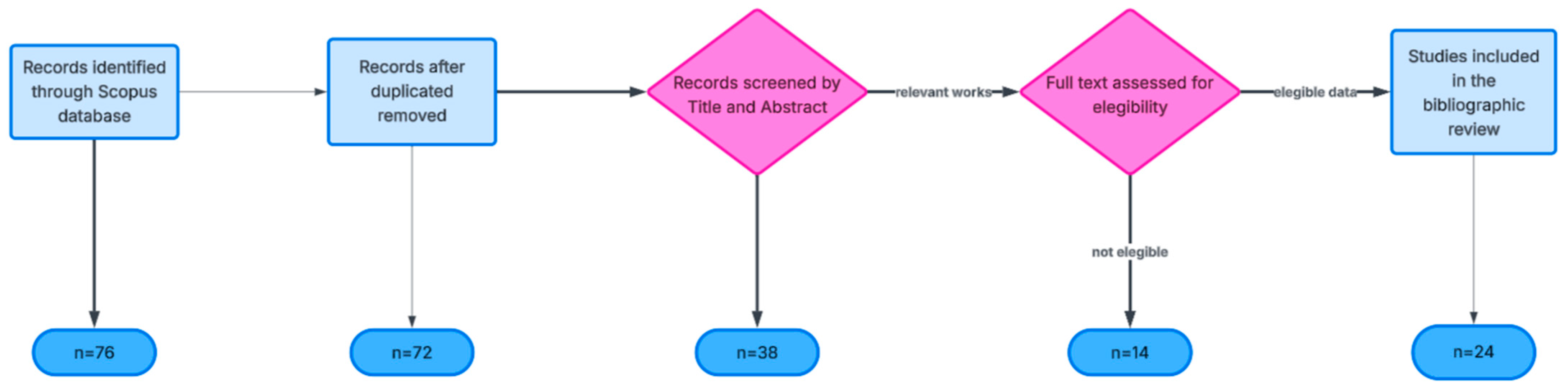
A Scopus search for the keyword “GeoBIM*” returned 76 publications, demonstrating a growing research interest at the intersection of BIM and GIS. The extracted dataset reflects global distribution patterns, publication formats, disciplinary orientation, and temporal dynamics of the field. The PRISMA diagram is shown in Figure 2. The output table (Table 1) is further discussed later to more deeply address the case studies.

4. Bibliometric Analysis

Advanced bibliometric mapping was conducted using VOSviewer version 1.6.17 software to explore co-occurrence patterns and collaboration structures. The Scopus search for the keyword “GeoBIM” returned 76 publications, demonstrating a growing research interest in the intersection of BIM and GIS. The extracted dataset reflects global distribution patterns, publication formats, disciplinary orientation, and temporal dynamics of the field. The bibliometric analysis aimed to characterize the scientific landscape of GeoBIM, energy efficiency, and shallow geothermal applications, identifying thematic trends, research clusters, and geographic patterns. The Scopus database was selected due to its broad coverage of engineering, geosciences and energy research, as well as the availability of structured metadata for bibliometric analysis. The search strategy combined terms related to GeoBIM, shallow geothermal systems, and energy efficiency, applied to titles, abstracts, and keywords. Publications in English and Portuguese were considered, including journal articles, reviews, conference papers and book chapters. The dataset was cleaned to remove duplicates and incomplete records, and keyword variants were harmonized using a thesaurus file. The final dataset supported descriptive indicators such as publication trends, document types, citation patterns and the identification of the most productive authors, institutions and countries. Subject area classifications were analyzed to define the disciplinary profile, mainly spanning engineering, energy, environmental sciences, geosciences and computer science, highlighting the interdisciplinary nature of GeoBIM.
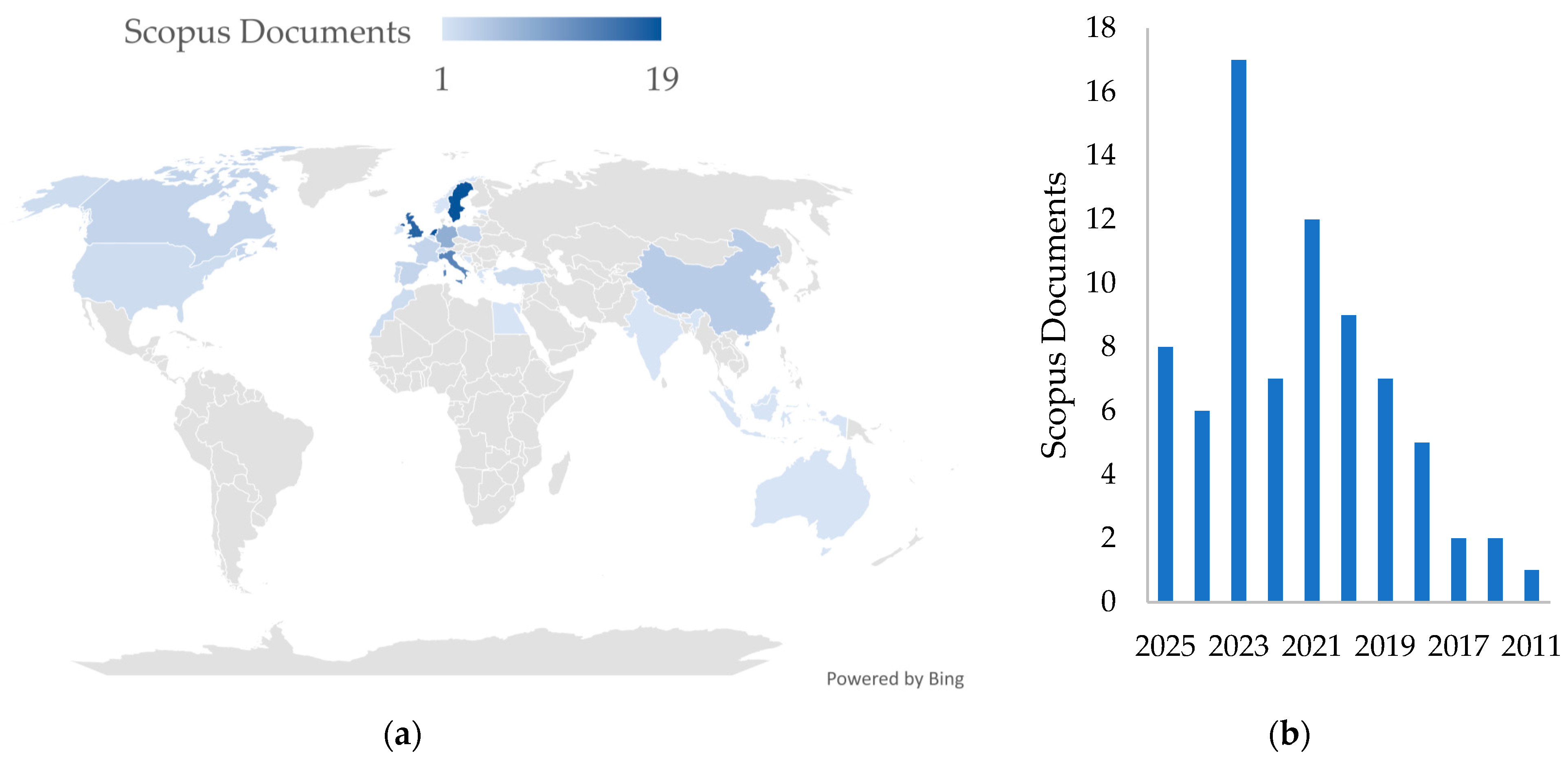
Authorship and geographic analyses showed a spatial concentration of research in Europe, North America and Asia, reflecting policy support and technological development. Co-authorship patterns indicate a growing but still consolidating research field, with publications distributed across engineering, energy and environmental journals. The research output (Figure 3) is concentrated in a limited number of countries, with a clear European predominance. The Netherlands and Sweden lead in publication volume, each with 19 documents, followed by the United Kingdom with 17. Moderate activity is observed in Italy, Germany, Singapore, and China, while Canada, France, Poland, and Spain show smaller but relevant contributions. A notable number of publications are classified as “Undefined”, reflecting collaborative research without explicit country attribution or incomplete metadata. Overall, this geographic distribution indicates that GeoBIM research is primarily driven by technologically advanced European regions with strong policy commitments to digitalization and smart-city development. The temporal distribution shows a marked increase in research activity after 2020. Publication peaks are observed in 2023 and 2024, following steady growth in 2020 and 2021, whereas earlier years show limited output. This trend aligns with global digitalization agendas, the emergence of digital twins and policy initiatives promoting interoperability, open standards, and smart-city development, as well as the broader adoption of BIM and geospatial digital infrastructures.
Bibliometric evidence indicates that GeoBIM is a rapidly expanding and interdisciplinary field, largely shaped by European research networks. The predominance of conference papers suggests an exploratory phase, with active research on interoperability, semantic mapping, 3D city modeling, building performance simulation and digital twins. Despite growing diversity and maturity, relatively few studies fully integrate GeoBIM with geothermal energy applications at a multiscale level, reinforcing the relevance of systematic reviews to consolidate existing knowledge and identify methodological and technical research gaps.

5. GeoBIM for Geothermal Energy

Building Information Modeling (BIM), standardized through ISO 19650:2018 [33], and Geographic Information Systems (GIS) have become complementary tools for digital representation and management of the built environment. BIM, supported by the Industry Foundation Classes (IFC), enables structured data exchange among construction professionals, while GIS relies on CityGML for semantic and geometric representation of cities and for multiscale geospatial analyses [15,19,34,35,36]. The integration of both approaches facilitates a continuous connection between the building scale and the territorial scale, supporting the development of smart and sustainable cities.
Geothermal-field modeling is an essential component in the assessment of natural geothermal resources or in the design of geothermal exploration systems. Different approaches, from simplified analytical models based on thermal gradients to fully coupled numerical modeling involving heat transport and fluid flow, are used depending on the scale and complexity of the geological system.
The geothermal field refers to the distribution of subsurface temperature as a function of depth and the thermal properties of the terrain. The basic geothermal gradient is empirically expressed by Equation (1):
T(z) = T0 + G.z,
where T(z) is the temperature at z (depth), T0 is the average annual surface temperature, and G is the local geothermal gradient measured in °C/km [37,38].
Although this linear model is useful for preliminary estimates, real geothermal systems often exhibit nonlinear variations in thermal properties and heat flow, requiring more-sophisticated models based on heat transfer and fluid flow equations. Fundamental analytical models are based on the heat diffusion equation [39], and are mainly used for steady-state scenarios and for geothermal gradient estimates in regional or local studies. With increasing computational capacity, advanced numerical models have been developed that couple heat transfer and fluid flow in porous and fractured media. This is the case with Finite Element and Finite Volume simulations, which are fundamental methods for simulating geothermal fields at regional and reservoir scales, including hydrothermal systems and Enhanced Geothermal Systems [40]. In highly fractured reservoir situations, single-, double-, and multiple-porosity models are used to describe heat and mass transport between the rock matrix and fractures [31]. Other situations utilize modern computational modeling, including optimizers and uncertainty quantification algorithms, to improve the prediction of operational geothermal-field performance [41]. Recently, machine learning-based approaches, including physics-informed neural networks (PINNs), have emerged and are being explored to model geothermal structures and predict thermal properties in regions not directly observed. These approaches combine physical fundamentals with real-world data and can improve modeling accuracy under conditions of high uncertainty [42].
However, the structural differences between IFC and CityGML create persistent interoperability challenges. Research has focused on geometric reconstruction and semantic mapping to ensure model consistency [19], yet full integration remains limited. Existing tools such as ArcGIS Pro 3.6 enable the import of BIM into GIS environments, although this transfer still results in geometric simplifications and partial loss of semantic detail, reducing the models to predominantly visual or exploratory formats. To address these constraints, advanced programming approaches have emerged, particularly Python-based methods capable of redefining attributes, within the most recent version the Python 3.14.3; establishing topological links between buildings, foundations and geological models; and embedding physical parameters such as thermal conductivity or permeability [19]. These advances reinforce GeoBIM as a strategic instrument for urban planning and infrastructure management, improving data transparency, supporting regulatory processes, and optimizing resource allocation.
The recent conclusions of the Council of the European Union [1] emphasize the need for coordinated strategies to accelerate geothermal energy deployment across the building lifecycle. Although BIM and GIS are not explicitly mentioned, the recommended actions require interoperable digital platforms capable of ensuring data accessibility, document traceability, and coordination among multiple institutions. GeoBIM aligns naturally with these objectives by enabling thermal simulation of buildings, assessing the feasibility of shallow geothermal systems, and integrating geospatial, geotechnical and energy datasets within a unified digital environment. The Council’s emphasis on training, data availability and innovation further reinforces the relevance of GeoBIM for supporting EU-wide energy transition initiatives and for operationalizing large-scale geothermal deployment in a transparent and evidence-based manner.
GeoBIM research has moved from conceptual interoperability studies toward application-oriented work on geotechnics, urban-scale sensing, regulatory workflows and AI-enabled decision support, but these strands remain fragmented and only partially connected to shallow geothermal energy and energy-efficiency agendas. The literature review below reinforces the relevance of GeoBIM as a multiscale digital framework, while also exposing persistent gaps in standards, automation, validation and deployment in real planning and permitting contexts [29,43,44]. Recent work extends GeoBIM from building envelopes to subsurface and geotechnical information, which is crucial for any geothermal-focused agenda. Kassou et al. [44] formalize GeoBIM workflows for infrastructure geotechnics, using parametric and generative design to integrate geotechnical models with BIM–GIS representations of linear infrastructure. Their results show that parametric objects tied to ground models can automate alternative alignments, excavation volumes and stability checks, yet they stop short of explicitly linking these workflows to thermal properties or geothermal simulations [44,45]. Furthermore, Fonsati et al. [46] demonstrate a pipeline that takes scattered geotechnical investigations at an ex-industrial site and translates them into GeoBIM-ready models, emphasizing data cleaning, stratigraphic modeling and transfer into a 3D information environment usable by both engineers and planners. Their approach underlines that heterogeneous legacy data and inconsistent semantics are major bottlenecks and that standardized geotechnical object classes are still missing from mainstream IFC/CityGML profiles. These contributions confirm that subsurface representation is technically feasible within GeoBIM but remains method-specific, with no widely adopted ontology for geotechnical, hydrogeological or geothermal parameters, which directly limits robust shallow-geothermal-potential mapping in BIM–GIS environments [45].
Regarding urban GeoBIM and reality capture for urban-scale works, the review highlights how sensing, remote data and model fusion can populate GeoBIM environments with detailed geometry and semantics relevant to energy and infrastructure planning [47]. Shao et al. [43] have proposed an urban GeoBIM construction method that fuses semantic LiDAR point clouds with as-designed BIM models via deep learning-based segmentation and coarse-to-fine graph-based matching. Their results report LiDAR segmentation accuracies around 90% and positioning errors for matched BIM objects on the order of centimeters, illustrating that high-fidelity, geo-referenced 3D city scenes can be generated efficiently for street furniture and buildings [43]. Moreover, Skrzypczak et al. [48] assess scan-to-BIM accuracy for building inventories, showing that point cloud-based reconstruction can reach centimetric tolerances, but that accuracy degrades with complex roof forms, occlusions and low-quality scans. The study stresses that many “as-built” models used in GeoBIM are still inconsistent with field reality, which can compromise energy simulations and clash detection for underground systems. Together, these works indicate that urban GeoBIM can be reliably populated using LiDAR and photogrammetry, but that error propagation into energy or geothermal assessments is poorly quantified, and almost no study connects scanning uncertainty with the reliability of long-term thermal performance predictions [43].
GeoBIM also applies to sustainability, permitting and digital twins, while several studies explore GeoBIM as a decision support platform for sustainability and regulatory tasks, extending beyond purely technical model integration. For example, Bernegger et al. [49] present a method that combines BIM and GIS to evaluate sustainability scenarios for new construction in Switzerland, using GeoBIM to simulate indicators such as land take, energy demand and mobility emissions under different design options. A companion work (Sustain GEOBIM) generalizes this approach to urban-development scenarios, confirming that spatially explicit indicators can be calculated directly from integrated BIM–GIS models. Meanwhile, Della Scala et al. [11] reviewed GeoBIM applications for building permit issuance and argue that GeoBIM can encode zoning rules, volumetric envelopes and energy constraints, enabling automated checks and transparent communication with authorities. Their state-of-the-art synthesis shows that most current implementations remain pilot-scale, with limited integration of environmental or geothermal constraints into permitting workflows [15]. In addition, Manganelli and Bernegger et al. [49,50] show how GeoBIM can embed sustainability indicators into authorization and scenario processes, directly anticipating the digital permitting and energy assessment roles discussed in the manuscript. Manganelli’s “meta-design” of a GeoBIM platform argues that sustainability criteria and indicators used in authorization processes can be systematically encoded into a GeoBIM environment, enabling consistent, transparent evaluation of urban transformation projects. The proposed platform links zoning, land-use, environmental constraints and project attributes, highlighting that indicator design and data structuring are as important as geometric modeling for fair and effective sustainability assessment. Their work demonstrates that scenario-based GeoBIM can support strategic planning and stakeholder dialogue, but also notes challenges around data acquisition, interoperability and institutional uptake. Thus, these contributions converge with the present review’s finding that GeoBIM is well-positioned to support regulatory automation and sustainable urban development, but that energy- and geothermal-specific criteria rarely appear in concrete permit-checking rules or municipal digital twins, limiting the operational impact for the energy transition.
Due to advanced technology adoption, software ecosystems and AI integration, even more recently, the literature also examines GeoBIM adoption factors, software integration and the role of AI, highlighting sociotechnical barriers that align with the challenges identified in the manuscript. Misbari et al. [51] investigate the feasibility of GeoBIM in the Pahang construction industry, showing that awareness and knowledge of GeoBIM among local companies are low, and that perceived benefits (coordination, clash detection, cost control) are offset by concerns about training, investment and unclear standards. The study suggests that national roadmaps and capacity-building efforts are crucial precursors to effective GeoBIM deployment, particularly in developing contexts [51,52]. Nonetheless, Hakim & El Yamani [53] discuss emerging software solutions for GeoBIM integration within digital twins, focusing on prototype tools that couple BIM, GIS and real-time sensor data for lifecycle asset management. Their contribution highlights the importance of open APIs, microservices and cloud platforms, but also reveals that workflows for incorporating geothermal sensors or subsurface monitoring into such digital twins have not yet been systematically explored.
Khan et al. [54] have reviewed the integration of BIM and artificial intelligence in construction projects, synthesizing challenges such as data fragmentation, lack of standardized datasets, model interpretability and organizational resistance. While not specific to GeoBIM, the review points to opportunities for AI-supported energy optimization, anomaly detection in HVAC systems and predictive maintenance, all of which could be extended to geothermal-field performance and dynamic control in GeoBIM frameworks. Ventura’s review [55] of European digital building permits (DBP) and Raj et al.’s BIM-based organizational framework for public agencies converges on the idea that regulatory digitalization is a precondition for exploiting GeoBIM in practice. Ventura maps European DBP initiatives and Horizon Europe projects (DigiChecks, ACCORD, CHEK), showing that DBP is increasingly framed as a sociotechnical system combining process redesign, human skills, and advanced tools such as BIM, GeoBIM and model checking to support Green Deal and Renovation Wave goals. DBP pilots move gradually from “digital paper” to automated rule checking, multi-criteria sustainability evaluation, and integration with building logbooks and data spaces, but implementations remain uneven across countries and cities. Additionally, Raj et al. [56] propose a BIM-based organizational framework for Italian public agencies, specifying roles, responsibilities, information requirements, and common data environment structures that enable BIM to support design review, procurement, and lifecycle management. Their case study highlights that successful adoption hinges on clear BIM mandates, standardized information exchanges—aligned with ISO 19650 [33]—and internal capacity-building, which collectively prepare agencies to handle future DBP and GeoBIM workflows. Svensson’s works [57,58] and more recent geotechnical data platforms demonstrate how GeoBIM can extend into subsurface modeling and uncertainty-governed design, which are critical for geothermal deployment. GeoBIM contributions for optimal geotechnical design establish a concept that connects data storage, geotechnical modelling, design, visualization and an uncertainty model into a single workflow. The GeoBIM database generalizes heterogeneous geodata to enable combined modelling of soil and rock properties, with pilots in large Swedish infrastructure projects showing improved communication, faster updates and more-optimized designs when 3D ground models are directly linked to design tools [58].
Focusing on energy resources for geothermal deployment, energy-focused studies outside the strictly GeoBIM-focused literature clarify resource contexts and potential synergies with multiscale modeling [15]. Zhang et al. [59] provide a national overview of geothermal resource distribution and development prospects in China, noting abundant low- and medium-enthalpy resources and calling for integrated planning tools to match resources with urban demand centers. Their emphasis on spatial planning and multiscale assessment frameworks echoes the core rationale for GeoBIM, yet GeoBIM itself is not explicitly addressed, indicating an opportunity for cross-fertilization between geothermal planning and BIM–GIS research. For other scenarios, the European policy stresses that shallow geothermal is strategic for decarbonizing heating and cooling, but also highlights regulatory fragmentation, lack of geoscientific data access and insufficient professional training. These issues directly align with the present article’s argument that GeoBIM can help bridge data and governance gaps by combining building-level models, territorial datasets and subsurface information in a shared digital environment [15]. Overall, the external energy literature supports the manuscript’s contention that shallow geothermal systems are underused despite strong technical potential, and that integrated digital frameworks such as GeoBIM are needed to align building design, subsurface characterization and policy targets at multiple scales [43].
Moretti et al. [60] use GeoBIM to integrate BIM-based building information with GIS-based context and inspection data, creating a unified environment for condition assessment of existing assets. Their approach enables spatially explicit representation of degradation, performance, and maintenance needs, supporting prioritization and long-term asset strategies. For geothermal systems, this suggests that GeoBIM could host long-term monitoring of geothermal performance, link it to building usage and climate data, and feed back into design and policy, but concrete demonstrations of such geothermal-focused asset management workflows are still missing [60,61]. Recent works [62,63,64] provide conceptual and historical foundations for GeoBIM, clarifying integration patterns, strengths and persistent weaknesses that affect all application domains. Hajji and Jarar Oulidi [62] conceptualize GeoBIM as the convergence of BIM and 3D GIS under a multiscale paradigm, distinguishing data-, application-, and model-level integration and reviewing issues of level of detail, semantic mismatches, and geometry representation. In addition, Glinka [63] performs a cross-sectional SWOT analysis of BIM–GIS integration, identifying strengths (rich semantics, improved coordination, enhanced analysis), weaknesses (lack of standards, semantic inconsistencies, high implementation costs), opportunities (smart cities, digital twins, automated permitting) and threats (vendor lock-in, fragmented policies, skills gaps). This structured view matches the challenges identified in energy and geothermal applications, especially interoperability and organizational capacity gaps. These foundational works support the review’s claim that semantic harmonization and robust interoperability frameworks remain central research challenges for GeoBIM in energy, geothermal and regulatory applications.

5.1. Case Studies

The practical implementation of GeoBIM has expanded significantly, illustrating its capacity to support both shallow geothermal systems and large-scale urban energy planning. Applications range from airports to university campuses, spas, agricultural facilities, and tourism developments. A notable example is Terminal E of Zurich Airport, where 306 of the 440 foundation piles were converted into energy piles, supplying 70 percent of cooling needs and 65 percent of heating demand for the terminal [65]. This case demonstrates the feasibility of embedding geothermal systems directly into the structural components of large and complex buildings.
Cureton and Hartley’s book [61] situates GeoBIM within broader discourses on geodesign and urban digital twins, reinforcing its role as part of a larger ecosystem of spatial decision support tools. They outline how geodesign links data, simulation, and stakeholder participation in iterative design cycles, using GIS, 3D modeling and immersive environments to test alternative urban futures. Urban digital twins are presented as continuously updated, data-rich models that integrate BIM, GIS and sensor streams, with GeoBIM forming a key layer for detailed built-environment representation and scenario testing. The authors have compiled over 100 projects and several detailed case studies, demonstrating applications that range from climate adaptation and mobility planning to energy and infrastructure, often relying on GeoBIM-like integrations to connect building-scale design with district-scale analysis. This framing reinforces the argument that GeoBIM for geothermal energy should be seen not only as a technical pipeline but as part of a geodesign digital twin ecosystem where geothermal options can be evaluated alongside other interventions in participatory, future-oriented workflows.
In Nanjing, the Langshi International community installed heat-exchange tubing in 1200 piles, achieving more than 40 percent energy savings in a residential complex of about 100,000 m2 [66,67]. Further research by Lu et al. [19] on the Zhu Gongshan Building confirmed the reliability of GeoBIM-driven energy simulations, with a deviation of only 2 percent between calculated and monitored heating needs. The study integrated climatic, geometric and construction data through Python scripts and assessed geothermal potential using GIS-based temperature field modeling. The results demonstrated adequate geothermal performance, although auxiliary heating was needed during the coldest months. These findings reveal the strength of an integrated BIM–GIS workflow for dynamic energy assessments, while also exposing limitations such as simplified soil assumptions and constant thermal exchange rates, which may not represent heterogeneous geological conditions. Broader applicability requires more robust soil characterization, refined dynamic modelling and long-term validation through real monitoring data.
In Portugal, the Ombria Resort represents the largest shallow geothermal installation in the country and the first fifth-generation district heating and cooling network. With multiple buildings connected through geothermal boreholes complemented by solar thermal collectors, the project illustrates the economic and technical viability of hybrid systems for large tourism developments [10]. The University of Aveiro’s robotics research building integrates a geothermal heat pump connected to 33 boreholes, delivering substantial reductions in primary energy consumption when compared with conventional systems [23]. This example highlights the contribution of geothermal heating and cooling to indoor thermal comfort and long-term operational savings. Other Portuguese cases, such as Caldas de São Paulo and the São Pedro do Sul geothermal agricultural greenhouses, demonstrate the potential of geothermal resources for thermal uses beyond the building sector. They also reveal vulnerabilities linked to extreme weather events, legal constraints, and infrastructure aging, reinforcing the need for real-time digital monitoring and GeoBIM-based risk-management strategies [26,68].
The reviewed studies reveal substantial diversity in how GeoBIM is implemented, both in terms of technical integration and energy-related outcomes. At the building scale, GeoBIM applications primarily focus on detailed thermal performance analysis and system sizing, leveraging BIM-based geometric and material data combined with GIS-derived climatic and geological information. Studies such as those by Shao et al. (2024) [43] report quantitative reductions in energy demand exceeding 40% when shallow geothermal systems are optimized using integrated BIM–GIS workflows. These results are generally validated through comparison with monitored operational data, with reported deviations below 5%, indicating high predictive reliability. At the district and urban scales, GeoBIM is used to assess spatial variability in geothermal potential, energy demand distribution and infrastructure interaction. While fewer studies provide direct quantitative energy savings at this scale, qualitative evidence shows improved planning efficiency, better system matching, and enhanced decision support for district heating and cooling networks. The integration depth varies significantly, ranging from simple BIM visualization within GIS platforms to advanced semantic and topological integration using customized data schemas and programming tools.
Table 1 summarizes other relevant case studies within the GeoBIM integration for geothermal and geotechnical applications according to their GeoBIM integration level. Low-integrated solutions are characterized by low computational demand and are mainly oriented towards visualization purposes, but they suffer from limited analytical depth and low accuracy. Medium-level integration enables more advanced analyses, including building- and district-scale performance assessment, although interoperability remains partial and information loss may still occur during data translation. While highly integrated solutions support multiscale optimization and integrated urban energy analysis, they entail high computational demand and face challenges related to implementation complexity, cost, and the need for specialized expertise.
From a qualitative perspective, studies with higher interoperability levels, typically achieved through mapping or custom semantic models, demonstrate superior analytical capacity and scalability. However, these approaches also exhibit higher computational complexity and implementation costs. Conversely, studies relying on simplified data exchange achieve faster implementation but often sacrifice analytical precision and long-term applicability. Across the literature, validation practices remain inconsistent. While some studies incorporate real operational data or long-term monitoring, others rely solely on simulations, limiting the robustness of conclusions. This gap highlights the need for standardized validation frameworks and performance indicators in GeoBIM-based energy studies.
Table 1. Literature review and case studies.
ReferenceApplication TypeSystem TypeGeoBIM Integration *Objectives
Liu et al. (2021)
[69]
BuildingGSHPData exchange (medium)Thermal performance optimization
de Laat & van Berlo (2010) [64]BuildingCityGMLData Exchange (high)GIS-BIM integration
Moretti et al. (2021) [60]BuildingEnergy metricsCondition assessment (low to medium)Indices and prioritization metrics
Shao et al. (2024)
[43]
BuildingEnergy pilesSemantic integration (high)System sizing and optimization
Skrzypczak et al. (2022)
[48]
BuildingScanningLaser integration for as-built (medium)Centimetric deviations for simple geometries
Raj et al. (2025)
[56]
BuildingDigital platformData optimization (low)Process indicators
Svensson et al. (2023) [58]UrbanGeotechnicsDesign optimization (medium)Geotechnical design
Fonsati et al. (2023)
[46]
UrbanGeotechnicsDesign optimization (medium)Geotechnical design
Kassou et al. (2025)
[44]
UrbanGeotechnicsDesign optimization (medium)Design variants and volumetric indicators
Barros et al. (2025)
[9]
UrbanHeating and coolingScenario modeling (medium to high)Spatial energy planning
Ventura (2025)
[55]
DistrictDigital permitsData exchange (low)Energy regulation
Della Scala et al. (2023)
[11]
DistrictDigital permitsPilot-scale implementations (medium to high)Energy constraints, volumetric limits and zoning compliance
Wang et al. (2019)
[15]
DistrictEnergy mappingVisual integration (low to medium)Energy efficiency assessment
Bernegger et al. (2022)
[49]
DistrictEnergy mappingScenario indicatorsLand take, energy demand and emissions
Manganelli (2023)
[50]
DistrictSustainabilityAuthorization platform (medium to high)Sustainability scores and compliance checks
Figueira et al. (2025) [10]DistrictShallow geothermal systemsScenario simulation (medium)Feasibility and performance assessment
* Level of integration defined as follows: for low-integration approaches, data exchange is predominantly manual or based on static file transfers, typically relying on proprietary formats; medium-integration approaches introduce semi-automated data exchange mechanisms; high-integration approaches are based on fully semantic and bidirectional data exchange.
The level of GeoBIM integration refers to the degree of interoperability between BIM and GIS within the analyzed studies proposed by the authors. The classification was derived from the type of data exchange workflow, the level of automation, and the semantic interoperability between datasets:
  • Low integration: BIM and GIS environments operate largely independently. Data exchange is performed manually or through static file transfers (e.g., CAD, shapefiles, or proprietary formats), typically requiring manual preprocessing and resulting in limited interoperability and no semantic linkage between models.
  • Medium integration: Partial interoperability is achieved through semi-automated workflows and standardized data formats (e.g., IFC, CityGML, or geodatabases). Data exchange may involve scripted transformations or middleware tools, enabling improved spatial alignment and attribute mapping, although bidirectional synchronization between BIM and GIS environments remains limited.
  • High integration: Full semantic and bidirectional interoperability is implemented between BIM and GIS. Data exchange relies on standardized schemas and semantic mapping mechanisms (e.g., IFC–CityGML integration), allowing automated workflows, consistent object semantics, and dynamic data synchronization across platforms. These approaches support integrated analyses such as coupled building–subsurface simulations and urban energy modeling.
The literature demonstrates that GeoBIM is applied across multiple spatial scales, with higher integration levels typically associated with building-scale geothermal applications, while urban-scale studies often prioritize spatial assessment over detailed system simulation. Quantitative evidence is strongest at the building scale, where monitored data is more readily available. Urban-scale studies often rely on scenario-based estimates, highlighting the need for standardized validation protocols. While high-integration GeoBIM frameworks enable advanced energy and geothermal analyses, their complexity and computational demands remain significant barriers to widespread adoption. Nonetheless, GeoBIM demonstrates clear advantages in improving energy analysis accuracy, supporting shallow geothermal system design and enabling multiscale assessment. Quantitative comparisons indicate that energy savings are achievable in optimized building-scale applications, particularly when energy piles and ground-coupled systems are incorporated early in the design process. Qualitatively, studies with deeper semantic integration show superior analytical capabilities but face greater implementation challenges. The comparison also reveals a methodological gap between building-scale and urban-scale applications, where quantitative validation is often limited. This imbalance underscores the need for harmonized evaluation metrics, improved interoperability standards and long-term monitoring data to strengthen the evidence base. Advantages and limitations, along with emerging gaps and future directions, are provided in the further subsections.

5.2. Integration for Geothermal Modeling

Interoperability remains a key challenge in GeoBIM workflows, particularly when integrating subsurface energy systems such as shallow geothermal infrastructure [68]. The BIM domain commonly relies on the IFC standard to represent detailed building components and engineering systems, whereas the geospatial domain frequently uses CityGML to model urban environments and their spatial context [70]. Although both standards support three-dimensional representations, they differ significantly in their data structures, semantic definitions, and intended scales of application. These differences can complicate the exchange and integration of information between BIM and GIS environments, particularly when attempting to represent both building systems and geological or underground elements within a unified modeling framework.
One of the main technical challenges concerns the harmonization of levels of detail (LODs) between the two standards [71]. In BIM models, levels of detail typically describe the geometric precision and information content of building components during different project phases, while in CityGML the LOD concept refers primarily to the spatial resolution of urban models, ranging from simplified building blocks to highly detailed representations. Aligning these different LOD definitions is necessary to ensure consistent representation of building geometry and associated infrastructure when transferring data between IFC and CityGML environments. Without such harmonization, discrepancies in model resolution may lead to inconsistencies in spatial analysis, energy modeling, or infrastructure planning [62].
Another important issue is the semantic alignment of subsurface objects, particularly when representing geothermal infrastructure such as borehole heat exchangers, underground pipes, and geological layers [72]. While BIM standards can represent mechanical systems and structural components with high semantic richness, subsurface geological features are often not explicitly defined within traditional schemas [46]. Recent research, therefore, focuses on extending existing schemas or developing mapping approaches that allow geothermal assets and underground thermal properties to be consistently represented across both standards [46]. Addressing these interoperability challenges is essential for enabling integrated GeoBIM workflows that support geothermal feasibility assessments, subsurface resource management, and energy-efficient urban planning.
GeoBIM can play an important role in supporting the deployment of shallow geothermal systems across different stages of the building and urban development lifecycle [6,73]. During the building design stage, BIM-based models could allow the integration of geothermal components such as borehole heat exchangers, ground-source heat pumps, and building energy systems within a unified digital environment. By linking these models with geospatial datasets describing geological formations, groundwater conditions, and thermal properties of the subsurface, designers can evaluate the feasibility of geothermal systems early in the planning process [69]. This integration supports more accurate system sizing, optimization of borehole placement, and the assessment of interactions between building energy demand and ground thermal behavior.
At broader spatial scales, GeoBIM also supports urban planning and operational decision support [60]. In the operational phase, GeoBIM environments may further support monitoring and management of geothermal installations by integrating sensor data, energy performance indicators, and subsurface temperature evolution within digital twin platforms. Such integrated approaches provide decision-makers with improved tools for evaluating long-term system performance, managing thermal interference between installations, and supporting the sustainable expansion of geothermal energy in urban environments [11].
A distinction can be made between geothermal-focused studies and GeoBIM-oriented research, as these two strands of the literature generally address different objectives and methodological approaches. Geothermal-focused papers typically concentrate on the technical performance and design of geothermal energy systems, such as ground-source heat pumps, borehole heat exchangers, or underground thermal storage [74,75]. These studies often emphasize aspects such as thermal response tests, ground thermal conductivity, borehole configuration, and system efficiency, using numerical simulations or field measurements to evaluate the performance of geothermal installations. While spatial data may be considered in these studies, the primary focus is generally on thermal behavior and energy system optimization, rather than on data integration or digital modeling environments [76,77,78].
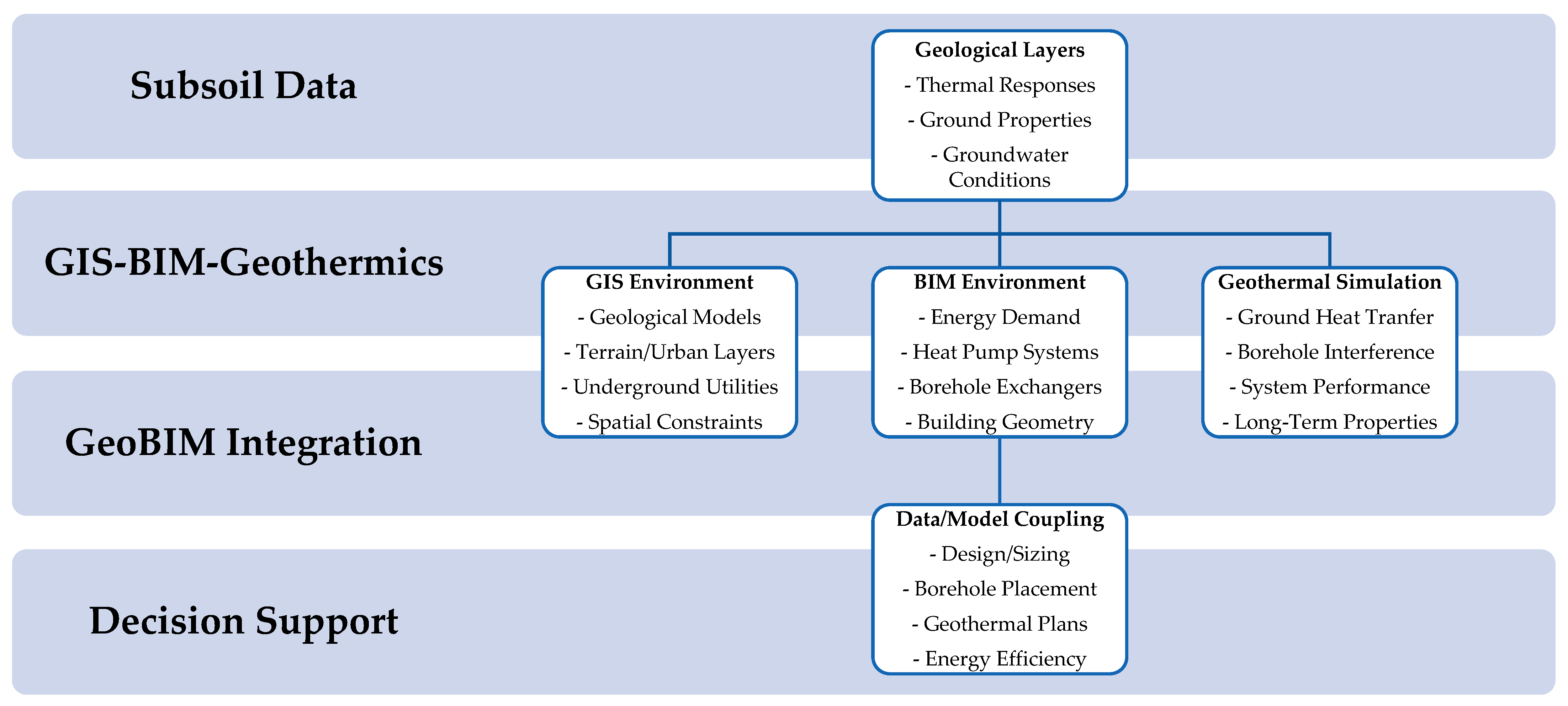
In contrast, GeoBIM-related studies primarily investigate the integration to support spatial data management, interoperability, and multiscale analysis in the built environment [57]. These studies focus on developing frameworks, data exchange mechanisms, and semantic mappings that enable the integration of building models with urban and geospatial datasets. When applied to geothermal energy systems, GeoBIM research aims to support decision-making by linking building energy demand, subsurface conditions, and urban spatial context within a unified digital environment [62]. Consequently, while geothermal-focused studies provide detailed insights into system performance and subsurface thermal processes, GeoBIM studies contribute by enabling integrated data workflows and spatial decision support tools that facilitate the planning and deployment of geothermal technologies at building and urban scales. Figure 4 illustrates a conceptual GeoBIM–geothermal workflow in which subsurface geological datasets, GIS-based spatial information, and BIM building models are integrated to support geothermal system simulation and decision-making.
Integrating shallow geothermal systems into GeoBIM environments requires the representation of subsurface thermal properties alongside building and urban datasets [79,80]. A critical aspect of integrating shallow geothermal systems within GeoBIM environments is the representation and management of subsurface thermal and geological information alongside building and urban datasets [60]. Key datasets include results from thermal response tests, ground thermal conductivity values, borehole depth and geometry, groundwater conditions, and underground temperature profiles. These parameters are typically obtained from field measurements, geological surveys, or regional geothermal databases [81]. Within a GeoBIM framework, such information can be incorporated as attribute data linked to spatial subsurface objects, such as borehole heat exchangers, foundation elements, or geological layers. GIS platforms often manage the spatial distribution of geological formations and temperature fields, while BIM models represent the building structure and energy systems, enabling a combined representation of surface and subsurface infrastructure [82]. Meanwhile, GIS provides spatial context through geodatabases and 3D city models, through semantic mapping between these schemas, subsurface objects, such as boreholes, geological layers, and thermal properties, can be linked to building elements and urban spatial datasets. This approach supports the creation of integrated digital environments where geothermal infrastructure is represented consistently across multiple spatial scales [45,62,63].
Simulation tools may require input parameters such as ground thermal conductivity, borehole spacing, system load profiles, and long-term thermal interference between boreholes [83]. Data exchange between GeoBIM environments and geothermal simulation software is typically achieved through structured data export, middleware scripts, or interoperable data formats. In such workflows, BIM models can provide building energy demand profiles and system configurations, while GIS datasets supply geological and spatial constraints affecting borehole placement and thermal performance. The integration of these datasets enables coupled building–subsurface simulations, where building energy demand and geothermal system performance are evaluated simultaneously, enhancing decision-making in the planning and design of energy-efficient buildings and sustainable urban energy systems [84].

5.3. Advantages and Limitations

GeoBIM expands the analytical capacity of urban energy systems by improving visualization and enabling integrated analyses of existing and future scenarios. It enhances the quality and interoperability of data, strengthens collaborative processes and supports resource optimization across multiple sectors [9,85]. By connecting territorial, environmental, and architectural information, GeoBIM provides a consistent framework for energy planning, mobility, infrastructure management and environmental assessment. Digital twins further amplify these benefits by enabling virtual testing prior to real implementation, increasing safety, and reducing costs.
In complex energy infrastructure projects, such as ultra-high-voltage transmission networks, GeoBIM facilitates three-dimensional representation, simulation workflows, and structured data sharing, improving design quality, operational safety and decision-making efficiency [9,86]. This consolidated evidence shows that GeoBIM is not solely a technological innovation but also a strategic asset for infrastructure modernization, energy transition, and the development of smart and resilient cities.
Despite its potential, GeoBIM still faces important challenges. Data interoperability between platforms remains limited due to divergent modeling standards, heterogeneous formats and inconsistent semantic structures [9,87]. Standardization is insufficient at the international level, affecting data exchange and the reproducibility of studies [88]. Professional capacity is also limited, since advanced digital tools require multidisciplinary knowledge and specialized training that many institutions have yet to adopt [87].
Institutional and technological barriers persist, including resistance to innovation, high implementation costs and infrastructural constraints [54,88,89]. Another difficulty lies in adapting these models to diverse socioeconomic contexts where resources, regulations and technical maturity differ. In the case of shallow geothermal energy, these challenges are intensified by outdated legal frameworks. In Portugal, regulations still follow criteria established in the 1990s, disregarding current technological developments and the diversity of geothermal applications. This situation contrasts with more-recent EU directives promoting regulatory simplification and small-scale renewable energy deployment [90]. The effective dissemination of GeoBIM and shallow geothermal technologies requires regulatory modernization, standardized interoperability models, digital-skills development, and targeted public policies aligned with international best practices.

5.4. Emerging Gaps and Future Directions

It should be noted that the analyzed studies exhibit methodological heterogeneity. While several publications present conceptual or methodological frameworks for GeoBIM integration, often relying on qualitative assessments of data workflows and interoperability mechanisms, other studies report applied implementations with quantitative indicators such as energy savings, geothermal system performance, or simulation results. This diversity reflects the emerging nature of GeoBIM research in the geothermal domain, where both conceptual development and practical experimentation contribute to advancing the field.
Synthesizing the above works with the case study evidence in the manuscript suggests several specific gaps and priorities that can strengthen the critical dimension of the review [43,91], namely:
  • Multiscale coupling and lifecycle integration: Current GeoBIM studies rarely connect detailed geothermal-field modeling (analytical, numerical or machine learning approaches) with building- and district-scale BIM–GIS representations; future research should explore standardized workflows to embed thermal properties, load histories and uncertainty into GeoBIM objects and simulations [44], in addition, DBP work focuses on early design and permitting, while asset management GeoBIM remains largely separate; few studies close the loop between design assumptions, operational performance (including geothermal systems) and subsequent regulatory or planning updates [55,61].
  • Standardization and semantics: There is still no widely adopted semantic model for geotechnical and geothermal attributes in IFC/CityGML; extending open standards or defining domain ontologies for shallow geothermal systems, bore fields and energy piles is essential to reproducible GeoBIM-based geothermal assessment [45], as well as for many sustainability indicators used in authorization processes, hampering repeatable, cross-jurisdictional workflows [61,64].
  • Data quality and validation: Reality-capture and scan-to-BIM studies demonstrate technical feasibility, but systematic evaluation of how geometric and semantic errors affect energy and geothermal simulation outcomes remains missing; long-term monitored case studies that link GeoBIM predictions to measured performance are needed [15]. In addition, geotechnical platforms illustrate how uncertainty can be explicitly modeled and communicated, but most GeoBIM applications in permitting, sustainability assessment and asset management still treat model inputs as deterministic; this is particularly problematic for geothermal potential assessment, where subsurface variability is high [58,61].
  • Regulatory integration: Although GeoBIM is increasingly proposed for permitting and sustainability assessment, energy and geothermal criteria are seldom operationalized within automated checks; further work should encode renewable energy and shallow geothermal rules directly into GeoBIM-based digital permitting platforms, aligned with evolving EU directives [15]. BIM-based organizational frameworks and SWOT analyses emphasize that standards, skills and change management in public agencies are lagging behind technical possibilities, limiting the uptake of GeoBIM for energy and geothermal policy implementation [55,56,63].
  • Sociotechnical and regional contexts: Adoption studies such as those from Malaysia show that local capacity, roadmaps and institutional support strongly condition GeoBIM implementation; comparative research across regions with different regulatory and market conditions would clarify how GeoBIM for geothermal energy can be tailored to varying levels of digital and institutional maturity [15,51].
  • AI and digital twins for geodesign: AI-enabled GeoBIM and digital twins are still at an early stage; integrating real-time geothermal monitoring, predictive control and fault detection into GeoBIM-based twins for buildings and districts represents a promising but largely unexplored frontier in geodesign. In addition, urban digital twins show powerful methods for participatory, multi-criteria exploration of urban futures, yet geothermal options and subsurface constraints are rarely integrated into these dialogues, missing opportunities for socially robust geothermal planning [61].
Addressing these gaps would position GeoBIM not merely as a tool for integrating BIM and GIS, but as a comprehensive, uncertainty-aware, and institutionally grounded framework for planning, authorizing, monitoring, and adapting shallow geothermal systems and broader energy efficiency strategies in smart cities.

6. Conclusions

This review confirms that GeoBIM represents a powerful and versatile framework for supporting energy efficiency and shallow geothermal applications in buildings and smart cities. By integrating detailed building-level information with territorial and subsurface datasets, GeoBIM enables multiscale energy analysis that improves data quality, enhances simulation accuracy and supports informed decision-making. Reported applications demonstrate significant energy savings, particularly when GeoBIM is applied during early design and planning stages. Despite these advantages, the review identifies several limitations that currently restrict large-scale adoption.
Interoperability between BIM and GIS standards remains a major technical challenge, compounded by insufficient standardization and high computational demands in advanced integration workflows. In addition, the lack of consistent quantitative validation across studies limits the comparability and generalization of results. Institutional barriers, including outdated regulatory frameworks and limited professional training, further constrain implementation, particularly for shallow geothermal systems.
Based on the findings of this review, several actions can support the practical implementation of GeoBIM for shallow geothermal systems. Urban energy planning frameworks should explicitly incorporate subsurface energy resources, supported by integrated GeoBIM datasets at the municipal level, while improved interoperability between BIM and geospatial standards is necessary to ensure consistent representation of subsurface infrastructure and geothermal assets. Furthermore, interdisciplinary professional training and the development of urban subsurface digital twins could enhance data integration, knowledge exchange, and decision support for the wider deployment of geothermal energy systems.
Future research should prioritize the development of standardized interoperability frameworks that enable seamless data exchange while preserving semantic richness. Greater emphasis should be placed on empirical validation through monitored case studies across diverse climatic and geological contexts. The integration of GeoBIM with digital twins, artificial intelligence and real-time sensing technologies also represents a promising direction, enabling adaptive control, predictive maintenance and dynamic optimization of urban energy systems. Overall, GeoBIM should be regarded not merely as a technical integration of BIM and GIS, but as a strategic enabler for sustainable, resilient and data-driven energy strategies in smart cities.

Author Contributions

Conceptualization, H.A.S.P., L.M.F.G., M.N., L.F.A.B. and L.M.; methodology, H.A.S.P., M.V.M. and L.M.; software, H.A.S.P. and L.M.; validation, L.J.A.P., V.G., M.V.M. and L.M.; formal analysis, H.A.S.P., L.M.F.G., L.J.A.P., M.N. and L.F.A.B.; investigation, H.A.S.P., L.M.F.G., L.J.A.P. and M.N.; resources, H.A.S.P., L.M.F.G., L.J.A.P., M.N. and L.F.A.B.; data curation, V.G. and M.V.M.; writing—original draft preparation, H.A.S.P. and L.M.; writing—review and editing, L.M.F.G., L.J.A.P., M.N., V.G. and M.V.M.; supervision, H.A.S.P., L.M.F.G., L.J.A.P., M.N. and L.F.A.B.; project administration, H.A.S.P. and L.M.; funding acquisition, L.J.A.P. All authors have read and agreed to the published version of the manuscript.

Funding

This research received no external funding.

Data Availability Statement

All data available is in this paper.

Acknowledgments

The authors acknowledge the support by the GeoBioTec Research Unit, through the strategic projects UIDB/04035/2025 and UIDP/04035/2025 (https://doi.org/10.54499/UID/04035/2025), funded by the Fundação para a Ciência e a Tecnologia, IP/MCTES (Portugal) through national funds (PIDDAC).

Conflicts of Interest

The authors declare no conflicts of interest.

References

  1. European Parliament and of the Council Geothermal Energy: Council Calls for Faster Deployment. Available online: https://www.consilium.europa.eu/en/press/press-releases/2024/12/16/geothermal-energy-council-calls-for-faster-deployment/ (accessed on 4 December 2025).
  2. European Parliament and of the Council Energias Renováveis. Available online: https://eur-lex.europa.eu/PT/legal-content/summary/renewable-energy.html (accessed on 4 December 2025).
  3. Bento, S.C.; de Melo Conti, D.; Baptista, R.M.; Ghobril, C.N. As Novas Diretrizes e a Importância do Planejamento Urbano para o Desenvolvimento de Cidades Sustentáveis. Rev. Gestão Ambient. E Sustentabilidade 2018, 7, 469–488. [Google Scholar] [CrossRef]
  4. Apanavičienė, R.; Shahrabani, M.M.N. Key Factors Affecting Smart Building Integration into Smart City: Technological Aspects. Smart Cities 2023, 6, 1832–1857. [Google Scholar] [CrossRef]
  5. Almulhim, A.I. Building Urban Resilience Through Smart City Planning: A Systematic Literature Review. Smart Cities 2025, 8, 22. [Google Scholar] [CrossRef]
  6. Yorucu, V.; Bekun, F.V.; Yitmen, I. Urban Resilience in Smart Cities: Lessons and Insights from a Global Perspective. In Modern Approach of Resilient and Sustainable Smart Cities; Springer Nature: Cham, Switzerland, 2026. [Google Scholar]
  7. Rathee, C.; Larimian, T.; Enoch, M.; Sadhukhan, S. Reimagining Sustainable Transport Through the Urban Metabolism Lens: A Review and Expert Synthesis. Sustain. Dev. 2026. [Google Scholar] [CrossRef]
  8. Freire, M.; Stren, R.E. The Challenge of Urban Government: Policies and Practices; World Bank Publications: Washington, DC, USA, 2001; ISBN 978-0-8213-4738-6. [Google Scholar]
  9. Barros, A.S.; Andrade, H.B.F.; Chagas, C.H.A.D.; da Silva, Y.C. O papel da integração de BIM e GIS na transformação de cidades em ambientes inteligentes e sustentáveis. Obs. Econ. Latinoam. 2025, 23, e10585. [Google Scholar]
  10. Figueira, J.; Cerdeira, R.; Madureira, P.; Coelho, L. Contexto atual do desenvolvimento de soluções de geotermia superficial em Portugal. Geotecnia 2025, 164, 243–266. [Google Scholar] [CrossRef]
  11. Della Scala, V.; Quaglio, C.; Todella, E. GeoBIM for Urban Sustainability Measuring: A State-of-the-Art in Building Permit Issuance. In International Conference on Computational Science and Its Applications; Springer Nature: Cham, Switzerland, 2023. [Google Scholar]
  12. Ferraro, N. Processo de modelagem digital BIM, 1st ed.; Editora Intersaberes Ltd.: Curitiba, Brazil, 2021; ISBN 978-65-5935-494-8. [Google Scholar]
  13. Lang, S.; Blaschke, T. Análise Da Paisagem Com SIG [Brazil Version]; Oficina de Textos: Sao Paulo, Brazil, 2009. [Google Scholar]
  14. Goodchild, M.F. Geographic Information Systems and Science: Today and Tomorrow. Procedia Earth Planet. Sci. 2009, 1, 1037–1043. [Google Scholar] [CrossRef]
  15. Wang, H.; Pan, Y.; Luo, X. Integration of BIM and GIS in Sustainable Built Environment: A Review and Bibliometric Analysis. Autom. Constr. 2019, 103, 41–52. [Google Scholar] [CrossRef]
  16. Kumar, K.N.; Jeevanantham, Y.A.; Kerur, S.S.; Kumar, S.P.; Ranjusha, J.P.; Sudhakar, M. A Multidisciplinary Approach to Sustainable Smart City Development: Cyber-Physical Systems. In Urban Mobility and Challenges of Intelligent Transportation Systems; IGI Global Scientific Publishing: Hershey, PA, USA, 2025; ISBN 979-8-3693-7984-4. Available online: https://services.igi-global.com/resolvedoi/resolve.aspx?doi=10.4018/979-8-3693-7984-4.ch023 (accessed on 4 December 2025).
  17. Casasso, A.; Sethi, R.G. POT: A Quantitative Method for the Assessment and Mapping of the Shallow Geothermal Potential. Energy 2016, 106, 765–773. [Google Scholar] [CrossRef]
  18. Ramalho, E.C.; Madureira, P.; Lourenço, C.; Francés, A.; Joyce, A.; Silva, L.D.; Silva, L. The Portuguese Platform for Shallow Geothermal and Its Role to Enhance the Portuguese Geothermal Market. Comun. Geológicas 2014, 101, 837–840. [Google Scholar]
  19. Lu, Y.; Dan, Z.; Bo, W.; Kang, R. A 3D Dynamic Evaluation Method of Shallow Geothermal Energy Development Suitability Based on Integration of BIM and GIS. Geol. J. China Univ. 2023, 29, 272–279. [Google Scholar] [CrossRef]
  20. Dulian, M. Geothermal Energy in the EU. Think Tank. European Parliament. Available online: https://www.europarl.europa.eu/thinktank/en/document/EPRS_BRI(2023)754566 (accessed on 9 December 2025).
  21. Dalla Longa, F.; Nogueira, L.P.; Limberger, J.; van Wees, J.-D.; van der Zwaan, B. Scenarios for Geothermal Energy Deployment in Europe. Energy 2020, 206, 118060. [Google Scholar] [CrossRef]
  22. Brandl, H. Energy Foundations and Other Thermo-Active Ground Structures. Geotechnique 2006, 56, 81–122. [Google Scholar] [CrossRef]
  23. Pinto, A.; Rodrigues, F.; Mota, A. Geothermal Contribution on Southern Europe Climate for Energy Efficiency of University Buildings. Winter Season. Energy Procedia 2017, 134, 181–191. [Google Scholar] [CrossRef]
  24. Cabeças, R.; Carvalho, J.; Nunes, J.; Sogeo; Geotérmica, S.; Rua, A.; Ataíde, F. Portugal Country Geothermal Update 2010. In Proceedings World Geothermal Congress; IGA: Reykjavik, Iceland, 2010; pp. 25–29. [Google Scholar]
  25. Schulte, T.; Zimmermann, G.; Vuataz, F.; Portier, S.; Tischner, T.; Junker, R.; Jatho, R.; Huenges, E. Enhancing Geothermal Reservoirs. In Geothermal Energy Systems; John Wiley & Sons, Ltd.: Weinheim, Germany, 2010; pp. 173–243. ISBN 978-3-527-63047-9. [Google Scholar]
  26. Dalla Santa, G.; Galgaro, A.; Sassi, R.; Cultrera, M.; Scotton, P.; Mueller, J.; Bertermann, D.; Mendrinos, D.; Pasquali, R.; Perego, R.; et al. An Updated Ground Thermal Properties Database for GSHP Applications. Geothermics 2020, 85, 101758. [Google Scholar] [CrossRef]
  27. de Sousa Figueira, J.D. Critical Aspects on Shallow Geothermal Energy Systems: Development, Design and Infrastructure-Scholar. PhD Thesis, Instituto Superior Técnico, Lisbon, Portugal, 2023. [Google Scholar]
  28. DGEG 2025; Plano Estratégico Para a Geotermia. Direção Geral de Energia e Geologia: Lisbon, Portugal, 2025.
  29. Wang, Y.; Liu, Y.; Dou, J.; Li, M.; Zeng, M. Geothermal Energy in China: Status, Challenges, and Policy Recommendations. Util. Policy 2020, 64, 101020. [Google Scholar] [CrossRef]
  30. Huang, S. Geothermal Energy in China. Nat. Clim. Change 2012, 2, 557–560. [Google Scholar] [CrossRef]
  31. Moher, D.; Shamseer, L.; Clarke, M.; Ghersi, D.; Liberati, A.; Petticrew, M.; Shekelle, P.; Stewart, L.A. Preferred Reporting Items for Systematic Review and Meta-Analysis Protocols (PRISMA-P) 2015 Statement. Syst. Rev. 2015, 4, 1. [Google Scholar] [CrossRef]
  32. Page, M.J.; McKenzie, J.E.; Bossuyt, P.M.; Boutron, I.; Hoffmann, T.C.; Mulrow, C.D.; Shamseer, L.; Tetzlaff, J.M.; Akl, E.A.; Brennan, S.E.; et al. The PRISMA 2020 Statement: An Updated Guideline for Reporting Systematic Reviews. Syst. Rev. 2021, 10, 89. [Google Scholar] [CrossRef]
  33. ISO 19650-1:2018; Organization and Digitization of Information about Buildings and Civil Engineering Works, Including Building Information Modelling (BIM)—Information Management Using Building Information Modelling Part 1: Concepts and Principles. ISO: Geneva, Switzerland, 2018.
  34. Beraldi, M. Integração GIS e BIM transformará o setor de Infraestrutura. Estúdio BIM Eng. Digit. BIM 2018. Available online: https://estudiobim.com.br/integracao-gis-e-bim-transformara-o-setor-de-infraestrutura/ (accessed on 9 December 2025).
  35. Correia, A. Notas de Geotermia Aplicada; Recursos Hidrogeológicos e Geoenergia; Universidade de Évora: Departamento de Física: Évora, Portugal, 2021. [Google Scholar]
  36. Corrêa, S.L.M.; Siviero, L.F.; de Oliveira Freitas, R.; Corrêa, F.R.; Santos, E.T. BIM para infraestrutura de transportes. Simpósio Bras. Tecnol. Informação E Comun. Construção 2019, 2, 1–8. [Google Scholar] [CrossRef]
  37. Gomes, L.M.F.; Guedes, J.F.; da Costa, T.C.G.; Ferreira, P.J.C.; Trota, A.P.N. Geothermal Potential of Portuguese Granitic Rock Masses: Lessons Learned from Deep Boreholes. Environ. Earth Sci. 2014, 73, 2963–2979. [Google Scholar] [CrossRef]
  38. Fridleifsson, I.B.; Bertani, R.; Huenges, E.; Lund, J.; Ragnarsson, Á.; Rybach, L. The Possible Role and Contribution of Geothermal Energy to the Mitigation of Climate Change. In IPCC Scoping Meeting on Renewable Energy Sources: Proceedings; IPCC: Lübeck, Germany, 2008. [Google Scholar]
  39. Geothermal Systems Engineering–Notes and Study Guides. Available online: https://fiveable.me/geothermal-systems-engineering (accessed on 26 December 2025).
  40. Dendys, M.; Tomaszewska, B.; Pająk, L. Numerical Modelling in Research on Geothermal Systems. Bull. Geography. Phys. Geogr. Ser. 2015, 39–44. Available online: https://apcz.umk.pl/BOGPGS/article/view/5398 (accessed on 9 December 2025). [CrossRef]
  41. Nugraha, R.P.; Oâ, J. Geothermal Modelling: Industry Standard Practices. In Proceedings of the 47th Workshop on Geothermal Reservoir Engineering, Stanford, CA, USA, 7–9 February 2022. [Google Scholar]
  42. Shima, A.; Ishitsuka, K.; Lin, W.; Bjarkason, E.K.; Suzuki, A. Modeling Unobserved Geothermal Structures Using a Physics-Informed Neural Network with Transfer Learning of Prior Knowledge. Geotherm. Energy 2024, 12, 38. [Google Scholar] [CrossRef]
  43. Shao, J.; Yao, W.; Wang, P.; He, Z.; Luo, L. Urban GeoBIM Construction by Integrating Semantic LiDAR Point Clouds With As-Designed BIM Models. IEEE Trans. Geosci. Remote Sens. 2024, 62, 5701712. [Google Scholar] [CrossRef]
  44. Kassou, F.; Bouayach, N.; Rguig, M. GeoBIM for Infrastructure Geotechnics: Parametric and Generative Design. Transp. Infrastruct. Geotechnol. 2025, 12, 290. [Google Scholar] [CrossRef]
  45. Khan, M.S.; Park, J.; Seo, J.; Khan, M.S.; Park, J.; Seo, J. Geotechnical Property Modeling and Construction Safety Zoning Based on GIS and BIM Integration. Appl. Sci. 2021, 11, 4004. [Google Scholar] [CrossRef]
  46. Fonsati, A.; Cosentini, R.M.; Tundo, C.; Osello, A. From Geotechnical Data to GeoBIM Models: Testing Strategies for an Ex-Industrial Site in Turin. Buildings 2023, 13, 2343. [Google Scholar] [CrossRef]
  47. Zahrizan, Z.; Nasly, M.A.; Marshall-Ponting, A.J.; Haron, A.T.; Zuhairi, A.H. An Exploratory Study on the Potential of Implementing Building Information Modelling (BIM) in Malaysian Construction Industry: Lesson Learnt from Singapore and Hong Kong Construction Industry; Penerbit UMP: Pahang, Malaysia, 2012. [Google Scholar]
  48. Skrzypczak, I.; Oleniacz, G.; Leśniak, A.; Zima, K.; Mrówczyńska, M.; Kazak, J.K. Scan-to-BIM Method in Construction: Assessment of the 3D Buildings Model Accuracy in Terms Inventory Measurements. Build. Res. Inf. 2022, 50, 859–880. [Google Scholar] [CrossRef]
  49. Bernegger, H.J.; Laube, P.; Ochsner, P.; Meslec, M.; Rahn, H.; Junghardt, J.; Aurich, I.; Ashworth, S. A New Method Combining BIM and GIS Data to Optimise the Sustainability of New Construction Projects in Switzerland. IOP Conf. Ser. Earth Environ. Sci. 2022, 1122, 012052. [Google Scholar] [CrossRef]
  50. Manganelli, B. Sustainability assessment in the authorisation process of urban transformation: The meta-design of a GeoBIM platform. SIEV 2023, 32, 121–131. [Google Scholar] [CrossRef]
  51. Misbari, S.; Ismail, S.N.A.; Ponniah, V. Feasibility Study of GEOBIM in Implementation of Construction Industry in Pahang, Malaysia. IOP Conf. Ser. Earth Environ. Sci. 2025, 1509, 012001. [Google Scholar] [CrossRef]
  52. CIDB. BIM Building Information Modeling Roadmap for Malaysia’s Construction Industry; Construction Industry Development Board Malaysia (CIDB): Kuala Lumpur, Malaysia, 2020. [Google Scholar]
  53. Hakim, A.; El Yamani, S. Development of Software Solutions for Advancing GeoBIM Integration in Digital Twins. In Digitalisation of the Built Environment: 3rd 4TU-14UAS Research Day; TU Delft OPEN Publishing: Delft, The Netherlands, 2024; pp. 39–42. [Google Scholar]
  54. Khan, A.A.; Bello, A.O.; Arqam, M.; Ullah, F. Integrating Building Information Modelling and Artificial Intelligence in Construction Projects: A Review of Challenges and Mitigation Strategies. Technologies 2024, 12, 185. [Google Scholar] [CrossRef]
  55. Ventura, S.M. Towards Digital Building Permits: A Review of European Strategies and Relevant Literature. TECHNE J. Technol. Archit. Environ. 2025, 30, 279–287. [Google Scholar] [CrossRef]
  56. Raj, K.; Ventura, S.M.; Comai, S.; Ciribini, A.L.C. Prioritising Categories of Controls for Their Automated Check in a Digitalised Building Permit Process in Europe: Insights from a Survey Study. In International Conference of Ar. Tec. (Scientific Society of Architectural Engineering); Springer Nature: Cham, Switzerland, 2025. [Google Scholar]
  57. Svensson, M. GeoBIM for Infrastructure Planning. In European Association of Geoscientists & Engineers Geophysics; European Association of Geoscientists & Engineers: Houten, The Netherlands, 2017. [Google Scholar]
  58. Svensson, M.; Siikanen, J.; Friberg, O. Digital Geotechnical Data Management Platform Enabling an Uncertainty Governed Geotechnical Design Process. In NSG2023 3rd Conference on Geophysics for Infrastructure Planning, Monitoring and BIM; European Association of Geoscientists & Engineers: Houten, The Netherlands, 2023. [Google Scholar]
  59. Zhang, J.; Chen, L.; Sun, Y.; Xu, L.; Zhao, X.; Li, Q.; Zhang, D. Geothermal Resource Distribution and Prospects for Development and Utilization in China. Nat. Gas Ind. B 2024, 11, 6–18. [Google Scholar] [CrossRef]
  60. Moretti, N.; Ellul, C.; Re Cecconi, F.; Papapesios, N.; Dejaco, M.C. GeoBIM for Built Environment Condition Assessment Supporting Asset Management Decision Making. Autom. Constr. 2021, 130, 103859. [Google Scholar] [CrossRef]
  61. Cureton, P.; Hartley, E. Geodesign, Urban Digital Twins, and Futures; Routledge: New York, NY, USA, 2025; ISBN 978-1-003-47131-8. [Google Scholar]
  62. Hajji, R.; Jarar Oulidi, H. GeoBIM: Towards a Convergence of BIM and 3D GIS. In Building Information Modeling for a Smart and Sustainable Urban Space; John Wiley & Sons, Ltd.: Weinheim, Germany, 2021; pp. 77–93. ISBN 978-1-119-88547-4. [Google Scholar]
  63. Glinka, S. Cross-Sectional SWOT Analysis of BIM and GIS Integration. Geomat. Environ. Eng. 2022, 16, 157–183. [Google Scholar] [CrossRef]
  64. de Laat, R.; van Berlo, L. Integration of BIM and GIS: The Development of the CityGML GeoBIM Extension. In Advances in 3D Geo-Information Sciences; Springer: Heidelberg/Berlin, Germany, 2010. [Google Scholar]
  65. Pahud, D.; Hubbuch, M. Measured Thermal Performances of the Dock Midfield Energy Pile System at Zürich Airport. In Proceedings of the European Geothermal Congress 2007, Unterhaching, Germany, 30 May–1 June 2007. [Google Scholar]
  66. Ng, C.W.W.; Farivar, A.; Gomaa, S.M.M.H.; Shakeel, M.; Jafarzadeh, F. Performance of Elevated Energy Pile Groups with Different Pile Spacing in Clay Subjected to Cyclic Non-Symmetrical Thermal Loading. Renew. Energy 2021, 172, 998–1012. [Google Scholar] [CrossRef]
  67. Kong, G.; Chang, H.; Wang, T.; Yang, Q. Review on the Evaluation of Ground-Coupled Heat Pump and Energy Geostructures to Exploit Shallow Geothermal Energy with Regional Scale. Rock Soil Mech. 2024, 45, 1. [Google Scholar] [CrossRef]
  68. Ferreira Gomes, L.; Madureira, P.; Figueira, J.; Pinto, C.; Pinto, H.; Ferreira, P. Seminário de Geotermia 2025-Energia Geotérmica em Portugal Situação Atual e Desafios para o Futuro 2025; Universidade da Beira Interior: Covilhã, Portugal, 2025. [Google Scholar]
  69. Liu, A.H.; Ellul, C.; Swiderska, M. Decision Making in the 4th Dimension—Exploring Use Cases and Technical Options for the Integration of 4D BIM and GIS during Construction. ISPRS Int. J. Geo-Inf. 2021, 10, 203. [Google Scholar] [CrossRef]
  70. El Mekawy, M.; Ismail, H.M. An Evaluation of IFC-CityGML Unidirectional Conversion for Road and Transportation Models. Int. Arch. Photogramm. Remote Sens. Spat. Inf. Sci. 2025, 48, 63–70. [Google Scholar] [CrossRef]
  71. Deng, Y.; Cheng, J.C.P.; Anumba, C. Mapping between BIM and 3D GIS in Different Levels of Detail Using Schema Mediation and Instance Comparison. Autom. Constr. 2016, 67, 1–21. [Google Scholar] [CrossRef]
  72. Elbalawy, M.A.; Balash, M.; Eid, M.H.; Takács, E.; Velledits, F. Innovative Method Integrates Play Fairway Analysis Supported with GIS and Seismic Modeling for Geothermal Potential Evaluation in a Basement Reservoir. Sci. Rep. 2025, 15, 1325. [Google Scholar] [CrossRef]
  73. Mêda, P.; Fauth, J.; Schranz, C.; Sousa, H.; Urban, H. Twinning the Path of Digital Building Permits and Digital Building Logbooks–Diagnosis and Challenges. Dev. Built Environ. 2024, 20, 100573. [Google Scholar] [CrossRef]
  74. Llanos, E.M.; Blessent, D. A Scoping Review of Numerical Modelling Studies of Geothermal Reservoirs: Trends and Opportunities Post-COP25. Int. J. Renew. Energy Dev. 2025, 14, 668–693. [Google Scholar] [CrossRef]
  75. Okoroafor, E.R.; Smith, C.M.; Ochie, K.I.; Nwosu, C.J.; Gudmundsdottir, H.; Aljubran, M. Machine Learning in Subsurface Geothermal Energy: Two Decades in Review. Geothermics 2022, 102, 102401. [Google Scholar] [CrossRef]
  76. Ng’ethe, J.; Jalilinasrabady, S. GIS-Based AHP Model for Selecting the Best Direct Use Scenarios for Medium to Low Enthalpy Geothermal Resources with Hot Springs in Central and Western Kenya. Geothermics 2024, 122, 103069. [Google Scholar] [CrossRef]
  77. Wang, F.; Meng, D.; Konietzky, H.; Gerolymatou, E.; Glover, P.W.J.; He, B.-G. A Discrete Element Approach for Simulating Progressive Fracturing in Geothermal Reservoirs via a New Cohesive Crack Model. Comput. Geotech. 2026, 192, 107908. [Google Scholar] [CrossRef]
  78. Zhang, W. MARS Applications in Geotechnical Engineering Systems: Multi-Dimension with Big Data; Springer Singapore: Singapore, 2020; ISBN 978-981-13-7421-0. [Google Scholar]
  79. Menberg, K.; Hemmerle, H.; Bayer, P.; Bott, C.; Bidarmaghz, A.; Ferguson, G.; Bloemendal, M.; Blum, P. Opportunities, Benefits and Impacts of Shallow Geothermal Energy. Nat. Rev. Earth Environ. 2025, 6, 808–823. [Google Scholar] [CrossRef]
  80. Eze, V.H.U.; Eze, E.C.; Alaneme, G.U.; Bubu, P.E. Recent Progress and Emerging Technologies in Geothermal Energy Utilization for Sustainable Building Heating and Cooling: A Focus on Smart System Integration and Enhanced Efficiency Solutions. Front. Built Environ. 2025, 11, 1594355. [Google Scholar] [CrossRef]
  81. Mari, J.-L.; Paixach, G. Geophysics in Geothermal Exploration: A Review; EDP Sciences: Les Ulis, France, 2025; ISBN 978-2-7598-3752-6. [Google Scholar]
  82. Pérez-Estay, N.; Molina-Piernas, E.; Roquer, T.; Aravena, D.; Araya Vargas, J.; Morata, D.; Arancibia, G.; Valdenegro, P.; García, K.; Elizalde, D. Shallow Anatomy of Hydrothermal Systems Controlled by the Liquiñe-Ofqui Fault System and the Andean Transverse Faults: Geophysical Imaging of Fluid Pathways and Practical Implications for Geothermal Exploration. Geothermics 2022, 104, 102435. [Google Scholar] [CrossRef]
  83. Gao, X.; Li, T.; Zhang, Y.; Kong, X.; Meng, N. A Review of Simulation Models of Heat Extraction for a Geothermal Reservoir in an Enhanced Geothermal System. Energies 2022, 15, 7148. [Google Scholar] [CrossRef]
  84. Marchiori, L.; Morais, M.V.; Studart, A.; Albuquerque, A.; Pais, L.A.; Gomes, L.F.; Cavaleiro, V. Energy Harvesting Opportunities in Geoenvironmental Engineering. Energies 2023, 17, 215. [Google Scholar] [CrossRef]
  85. da Rosa, S.C.; Marchiori, F.F.; Reginato, V.; da Silva, R.F.T. Estado da arte da integração GIS x BIM no contexto das cidades inteligentes. SIMPÓSIO Bras. GESTÃO E Econ. CONSTRUÇÃO 2023, 13, 1–10. [Google Scholar] [CrossRef]
  86. Sandra Cohen Como a State Grid Se Tornou a Líder do Setor Elétrico Brasileiro. Available online: https://epocanegocios.globo.com/Empresa/noticia/2019/07/como-state-grid-se-tornou-lider-do-setor-eletrico-brasileiro.html (accessed on 4 December 2025).
  87. da Costa Barros, F.; de Melo, H.C. Estudo sobre os benefícios do BIM na interoperabilidade de projetos. Rev. Científica Multidiscip. Núcleo Conhecimento 2020, 8, 74–91. [Google Scholar] [CrossRef]
  88. Cheng, Q.; Tayeh, B.A.; Abu Aisheh, Y.I.; Alaloul, W.S.; Aldahdooh, Z.A. Leveraging BIM for Sustainable Construction: Benefits, Barriers, and Best Practices. Sustainability 2024, 16, 7654. [Google Scholar] [CrossRef]
  89. Khalil, A.; Attom, M.; Khan, Z.; Astillo, P.V.; El-Kadri, O.M. Recent Advancements in Geothermal Energy Piles Performance and Design. Energies 2024, 17, 3386. [Google Scholar] [CrossRef]
  90. European Parliament and of the Council. Directive (EU) 2018/2001 of the European Parliament and of the Council of 11 December 2018 on the Promotion of the Use of Energy from Renewable Sources (Recast) (Text with EEA Relevance.); European Union: Luxembourg, 2018; Volume 328. [Google Scholar]
  91. Rahim, O.A.; Yin, H.; Ullah, S.; Durrani, A.N. Integrated Remote Sensing and GIS-Based Analytical Hierarchy Process for Groundwater Potential Mapping. Environ. Earth Sci. 2025, 84, 630. [Google Scholar] [CrossRef]
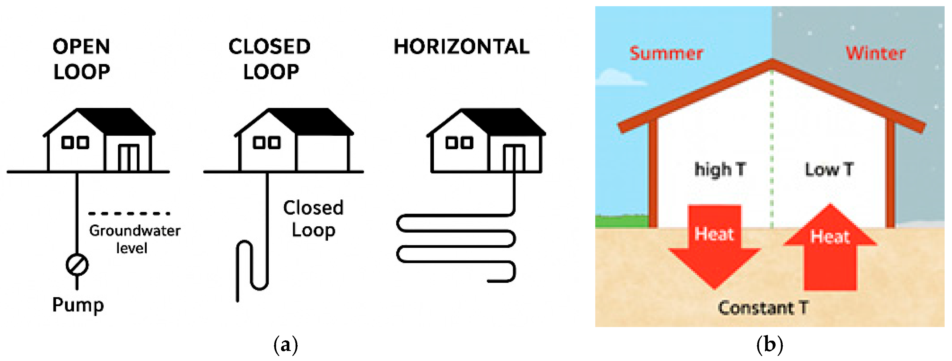
Figure 1. Schematic diagram of the most used low-enthalpy shallow geothermal systems (a) and the seasoning influence on the soil–environment energy transfer of geothermal technology (b).
Smartcities 09 00054 g001
Figure 2. Schematic diagram of the PRISMA protocol used in this review.
Smartcities 09 00054 g002
Figure 3. Worldwide distribution (a) and yearly distribution (b) of the documents in the Scopus database search.
Smartcities 09 00054 g003
Figure 4. Conceptual GeoBIM–geothermal workflow illustrating the integration of subsurface datasets, GIS-based spatial information, and BIM building models to support geothermal system simulation and decision-making.
Smartcities 09 00054 g004
Disclaimer/Publisher’s Note: The statements, opinions and data contained in all publications are solely those of the individual author(s) and contributor(s) and not of MDPI and/or the editor(s). MDPI and/or the editor(s) disclaim responsibility for any injury to people or property resulting from any ideas, methods, instructions or products referred to in the content.