
Article

Cultural Heritage Protection and Flood Hazard Control in Arid Areas: A Case Study of Xixia Imperial Tombs in China

Department of Arts and Cultural Management, Hongik University, 94 Wausan-ro, Mapo-gu, Seoul 04066, Republic of Korea
*
Author to whom correspondence should be addressed.
Heritage 2026, 9(5), 168; https://doi.org/10.3390/heritage9050168
Submission received: 15 February 2026 / Revised: 27 April 2026 / Accepted: 27 April 2026 / Published: 29 April 2026

Abstract

Cultural heritage sites in arid regions are often underestimated in terms of flood risk; however, the increasing frequency and intensity of extreme precipitation events under climate change have significantly amplified threats to these fragile environments. Taking the Xixia Imperial Tombs in China as a case study, this research investigates strategies for flood hazard prevention and control for cultural heritage in arid areas. By situating the study within the broader context of climate change and global heritage conservation, the paper examines the impacts of flooding on heritage sites and the historical evolution of flood control measures. It further integrates an analysis of the site’s geographical characteristics, traditional flood management structures, and contemporary conservation practices. The study systematically elucidates the compound risks of “drought–desertification–sudden flooding” faced by cultural heritage in arid landscapes. The findings suggest that heritage protection should transition from reactive, post-disaster restoration toward proactive preventive conservation. This shift requires the integration of both engineering and non-engineering measures, supported by technology-based systems such as environmental monitoring and early warning platforms, to establish a comprehensive risk management framework. The research highlights that overcoming the prevailing misconception that “arid regions are free from flood risks,” embedding heritage flood management into regional planning, and ensuring legal, financial, and interdisciplinary cooperation are essential for the long-term safeguarding of cultural heritage in arid environments. This study offers practical insights and a transferable reference for the protection of heritage sites in similar climatic and geographical contexts worldwide.

1. Introduction

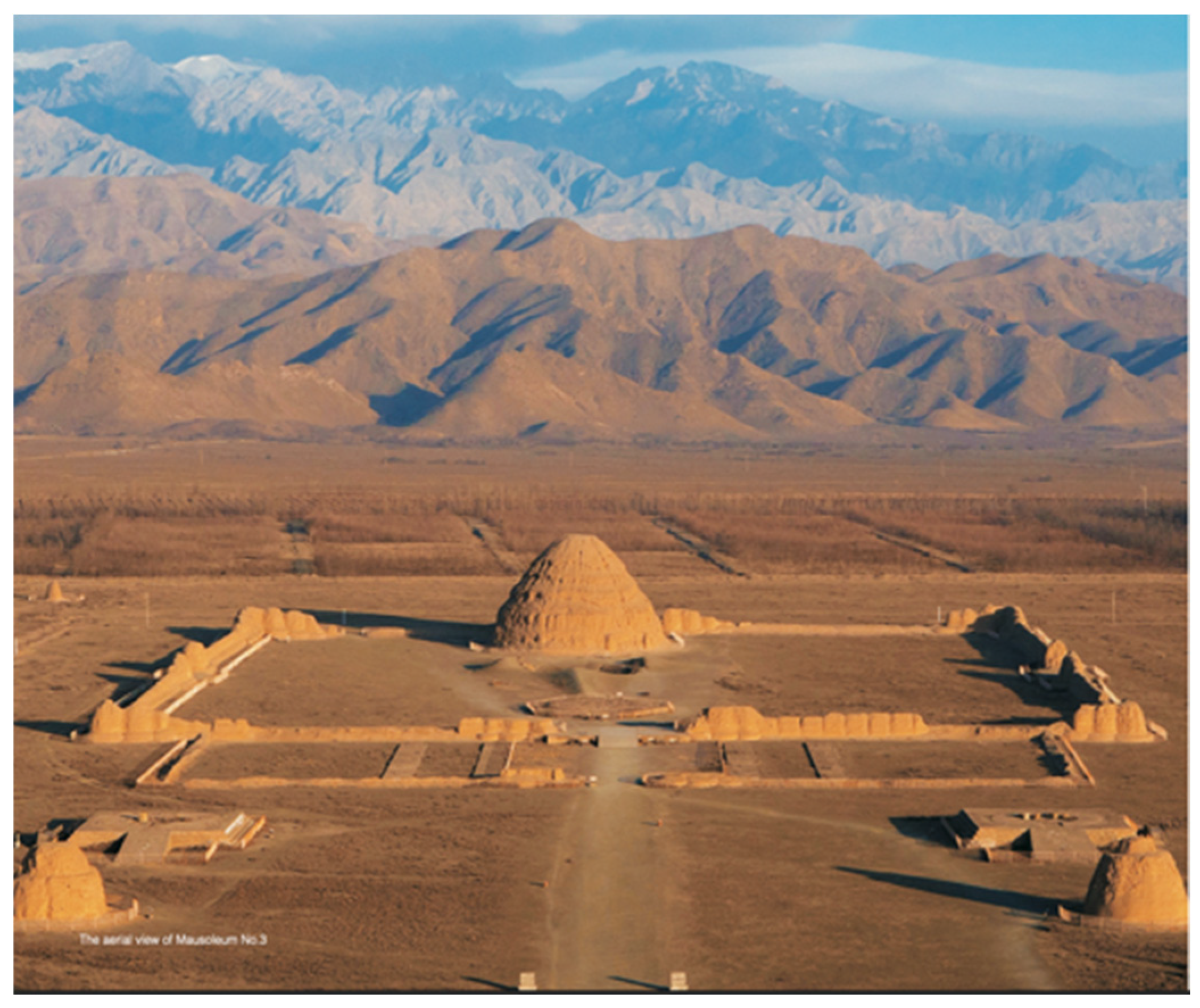
The Xixia Imperial Tombs (Figure 1), located on the alluvial fan of the eastern foothills of the Helan Mountains in Ningxia, China, represent the largest and best-preserved royal mausoleum complex of the Xixia Dynasty (11th–13th century). Despite being situated in an arid to semi-arid zone with low annual precipitation (approximately 180–200 mm), the site contains 32 documented flood control structures—including ancient flood control walls and drainage channels—dating back to the Xixia period. This seemingly paradoxical combination of “arid climate” and “extensive flood infrastructure” points to a historically recognized but increasingly overlooked reality: episodic but intense summer rainstorms in the Helan Mountains can generate flash floods that pose severe threats to the rammed-earth heritage.
In July 2020, a sudden flash flood triggered by extreme rainfall devastated the nearby Helan Mountain rock art sites, causing irreversible losses including surface rupture, exfoliation, and partial disappearance of petroglyphs. The Xixia Imperial Tombs escaped direct damage on that occasion, largely due to the protective function of existing flood control canals and walls. However, this near-miss event exposed two critical vulnerabilities. First, many of the ancient flood control structures had deteriorated over centuries of neglect, with only limited attention paid to them during early archeological investigations. Second, the site lacked a systematic, real-time mechanism for monitoring hydrological risks and enabling proactive response.
Against this background, this study addresses three central research questions: (1) Why is flood risk management critically important for the Xixia Imperial Tombs, despite their arid setting? (2) What are the limitations of relying solely on traditional engineering measures for heritage protection in arid environments? (3) How can a shift from reactive, post-disaster repair toward preventive conservation be operationalized at the site? By integrating archival research, field observations, and analysis of the newly established XIT Heritage Monitoring and Early Warning Platform (2024), this study aims to develop a transferable framework for flood hazard control at cultural heritage sites in arid regions, where the compound risks of drought, desertification, and sudden flooding are increasingly exacerbated by climate change.

2. Literature Review: Flood Risk and Cultural Heritage in Arid Regions

Climate change poses increasing threats to cultural heritage worldwide, with floods among the most frequent and damaging natural disasters [2]. According to ICOMOS, disaster risks to cultural heritage can be categorized into predictable deterioration and unpredictable catastrophic events [3]. While gradual climate changes accelerate long-term degradation processes, sudden climatic stressors—such as extreme precipitation and flooding—can cause abrupt and often irreversible damage [4]. Despite this global pattern, research on flood-induced damage to cultural heritage remains unevenly distributed. System reviews have revealed that existing studies are heavily concentrated in Europe, while regions such as Asia and Africa—particularly the heritage types located in arid environments—remain significantly understudied [4,5].
In response to these growing risks, international frameworks have evolved toward more comprehensive approaches. The European Union’s Floods Directive (2007/60/EC) explicitly includes the safeguarding of cultural heritage within flood management, addressing prevention, protection, and preparedness [6]. However, national implementations have often remained reactive. In Italy, flood risk management has been characterized as largely “disaster-driven”, with legal and policy frameworks emerging primarily as responses to major flood events rather than from forward-looking planning [7]. Similarly, studies from the Czech Republic have identified inadequate stakeholder communication and insufficient consideration of heritage-specific vulnerabilities as persistent gaps [8]. These limitations have prompted calls for a paradigm shift from passive, post-disaster response toward proactive, preventive conservation.
In contrast, recent scholarship from Taiwan has emphasized spatially integrated and preventive approaches. Wang demonstrated the application of flood risk maps overlaid with cultural heritage assets using GIS, enabling the identification of at-risk sites prior to flood events [9]. This study also proposed using urban parks as temporary flood retention areas, thereby integrating heritage protection into broader urban green infrastructure planning. More broadly, emerging digital technologies—including remote sensing, augmented reality, and blockchain—are expanding the scope of heritage documentation, monitoring, and stakeholder coordination [10,11,12]. Nevertheless, as Noblie et al. caution, large-scale flood maps often fail to capture the spatial distribution of dispersed cultural heritage assets, highlighting the need for finer-scale, site-specific modeling [2].
Within arid and semi-arid regions, floods are particularly prone to being overlocked due to long-term drought conditions. When extreme precipitation events do occur, however, they tend to cause disproportionately severe damage. Berenfeld documented this compound risk in Mauritania and Senegal, where prolonged desertification hardens soil surfaces, reducing infiltration capacity and generating flash floods that impact earthen architecture [13]. I refer to this phenomenon as a destructive cycle of “drought-desertification-sudden flooding” impacting fragile heritage sites. As Qu et al. have demonstrated through the case of the Mogao Grottoes in Dunhuang, large-scale environmental interventions—such as afforestation for desertification control, can have unintended consequences, including increased humidity within grottoes and accelerated mural deterioration [14].
Taken together, the literature reveals three significant gaps that this study addresses. First, research on flood risk management for cultural heritage in arid regions remains scarce, despite the unique compound risks these environments present. Second, existing studies rarely integrate detailed, site-specific field assessment of flood control infrastructure models that synthesize engineering, environmental, and governance dimensions specifically for arid-region heritage. The Xixia Imperial Tombs case study is well-positioned to address these gaps, offering both empirical data from field investigation and a conceptual framework for preventive conservation in drought-prone flood-vulnerable landscapes.

3. Historical Background of Xixia Imperial Tombs

Xixia Imperial Tombs constitute the royal mausoleum group of the Xixia Dynasty (11th to 13th century A.D.) and represent the largest, highest-ranking, and best-preserved archeological site from the Xixia period [1]. The site is located on an alluvial fan at the eastern foothills of the Helan Mountain, approximately 35 km west of Yinchuan City in the Ningxia Hui Autonomous Region, China. Extending from Quanqigou in the north to the Yinba Highway in the south, the tomb complex spans approximately 10 km from north to south and a width of 4 km from east to west, covering an area of nearly 40 km2. The Imperial Tombs area comprises 9 imperial mausoleums and 271 associated subordinate burials, occupying a core area of approximately 5.03 hectares, and is supported by 32 flood control structures [1]. In addition, numerous kiln sites used for firing bricks and ceremonial objects are distributed across the eastern sector of the cemetery.
Although the Xixia Imperial Tombs were largely destroyed by the Mongol forces following the collapse of the Xixia Dynasty in the early thirteenth century, leaving only remnants of walls and architectural ruins, the original scale and ceremonial order of the complex remain evident. The spatial layout, monumental earth mounds, and axial organization of the cemetery convey the former grandeur of the above-ground structures (Figure 2). As with most imperial mausoleums in traditional China, the construction of the Xixia Imperial Tombs reflects cosmological principles rooted in the balance of Yin and Yang and the practice of Fengshui. The selection of the burial site was based on the belief that harmony between natural forces would ensure the eternal preservation of the ruler’s spirit and the continuity of the landscape. Consequently, the cemetery was deliberately located on gently sloping terrain, backed by prominent mountains that were regarded as “sacred mountains” imbued with spiritual significance [15]. During his lifetime, the Xixia ruler would use the Helan Mountains as a royal hunting and ceremonial ground, where activities such as hunting expeditions, banquets, and court assemblies were held [16]. After death, the monarch was symbolically returned to this sacred landscape, reinforcing the enduring connection between royal authority, natural geography, and mortuary practice in Xixia culture.
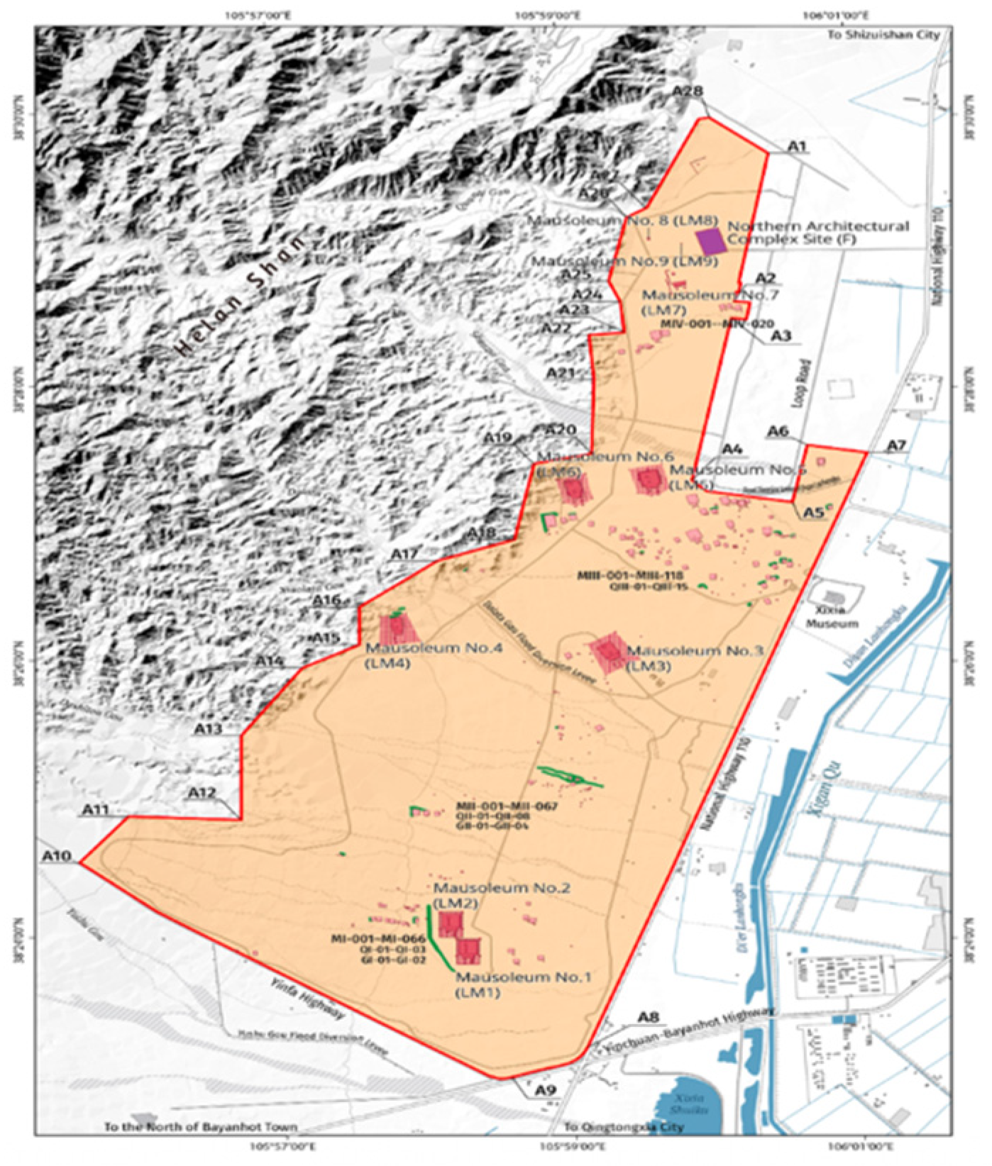
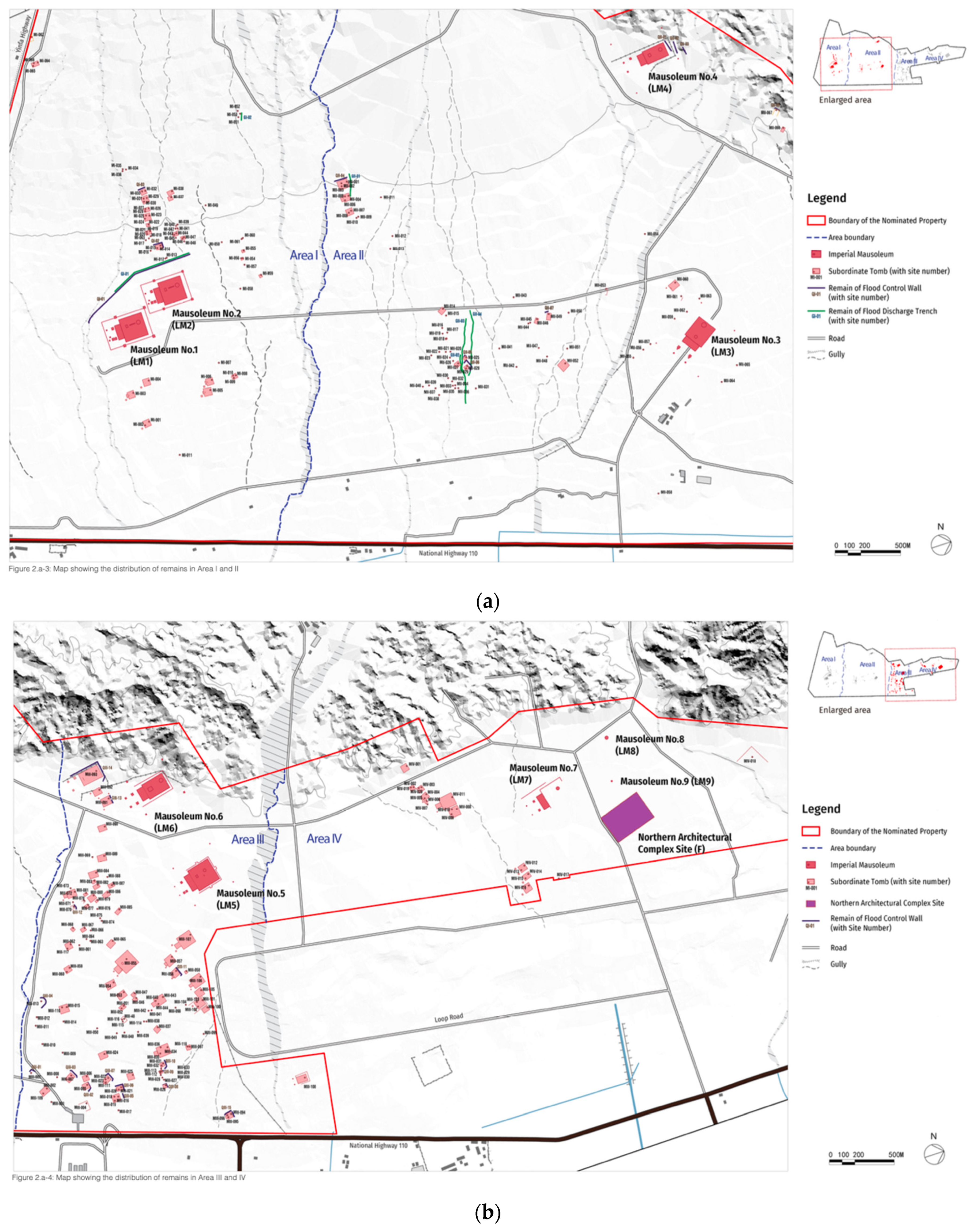
The heritage site is mainly divided into four zones based on the clustering and distribution of tombs. As illustrated in Figure 3, Area I comprises two principal imperial mausoleums (LM1 and LM2), 66 associated subordinate burials (MI-001 to MI-066), three flood control wall structures (QI-01 to QI-03), and two flood discharge channels (GI-01 to GI-02). Area II contains two principal mausoleums (LM3 and LM4), 67 subordinate burials (MII-001~MII-067), eight flood control wall structures (QII-01 to QII-08) and four flood discharge channels (GII-01 ~ GII-04) (Figure 3a). Area III comprises two principal imperial mausoleums (LM5 and LM6), 118 subordinate burials (MIII-001 to MIII-118), and 15 flood control wall structures (QIII-01 to QIII-15). Area IV includes three principal imperial mausoleums (LM7, LM8 and LM9), 20 subordinate burials (MIV-001 to MIV-020), and the Northern Architectural Complex Site (F) (Figure 3b). At present, Areas I and II are open to the public, whereas Areas III and IV are subject to restricted access and remain under conservation-focused protection.
Beyond the classical historical descriptions of Xixia mortuary practice [15,16], recent archeological scholarship has advanced the understanding of the spatial organization and site-selection principles of the Xixia Imperial Tombs. Zhang and Liu employed a “four-step method” combining historical analysis, field survey, environmental reconstruction, and GIS verification to demonstrate that the mausoleums were designed in visual dialog with the Helan Mountains, embodying a “landscape-mausoleum harmony” principle [17]. Further, Wang and Wang analyzed historical records and site conditions to identify the composite factors influencing tomb location, including proximity to the capital, mountain topography, fengshui considerations, and the personal preferences of Xixia rulers [18]. Together, these recent studies provide a refined understanding of Xixia mortuary spatiality that complements the traditional historical sources cited in earlier work.

4. Environmental Threats to Rammed Earth Mausoleums

The Xixia Imperial Tombs’ primary architectural structures are constructed using rammed earth technology. The conservation of rammed earth heritage is widely recognized as a global challenge. Although rammed earth construction techniques emerged as early as the Neolithic period and were extensively employed in ancient architecture, it is relatively rare for such structures to remain in a comparatively intact state after centuries or millennia of exposure to wind, rain, and other environmental stressors.
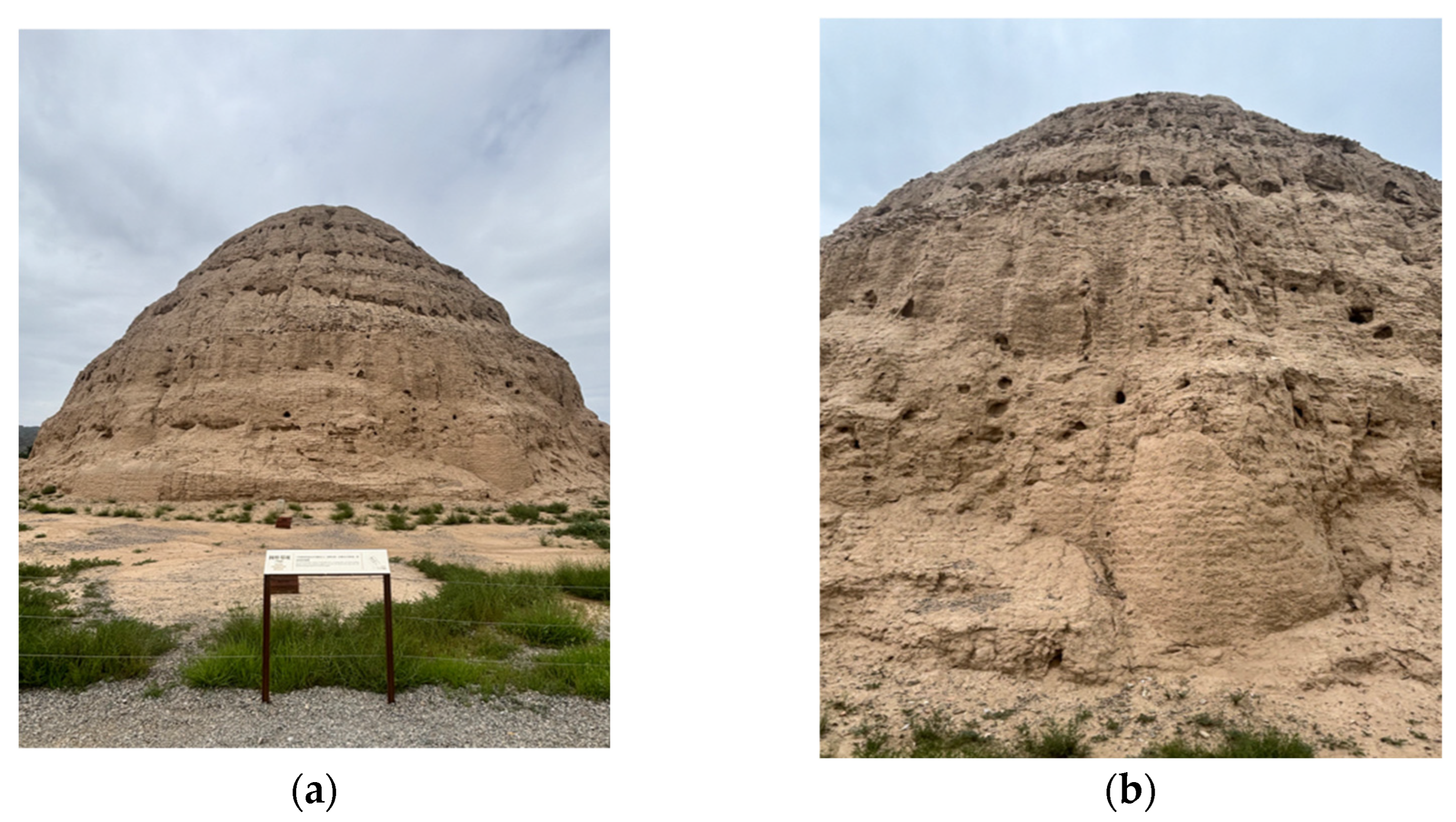
At the Xixia Imperial Tombs, the stratified construction of rammed earth is clearly visible in both the surviving walls and the tall mausoleum towers (Figure 4), reflecting a typical ancient building practice in which soil was compacted layer by layer through repeated ramming [19]. Archeological investigations have further revealed that, in the mausoleum tower of No. 3, carefully selected white lime and gravel were mixed into the rammed earth in specific proportions. This compositional refinement significantly enhanced the compressive strength and durability of the earthen structures, demonstrating a high level of technical knowledge in Xixia construction practices.
Despite these material and technological advantages, the Xixia Imperial Tombs are inevitably subject to natural aging processes. Located within an arid to semi-arid climatic zone, the site faces multiple environmental threats, including flood-induced gully erosion, drought-related cracking, and progressive surface weathering. If left unaddressed, the cumulative effects of these processes can compromise the long-term structural stability of the monuments. Particularly severe is the combined impact of salt crystallization and flooding. Salts are transported into the earthen fabric by infiltrating water and subsequently crystallize as moisture evaporates, generating internal stresses through volumetric expansion [19]. Repeated cycles of dissolution and crystallization gradually weaken the rammed earth, leading to loosening, flaking, and surface detachment. Under such conditions, sudden flash floods can trigger gully erosion that may cause rapid and irreversible damage to the earthen structures.

5. Existing Ancient Flood Control Structures of Xixia Imperial Tombs

Twenty-one structures were selected for detailed assessment according to the following explicit criterias: (i) structures located in hydrologically active flow paths identified from topographic maps and historical flood records; (ii) facilities from all four management zones (Areas I-IV) to ensure spatial representativeness; (iii) structures exhibiting visible distress (cracking, settlement, erosion) during preliminary site reconnaissance; and (iv) accessibility for safe on-site inspection without compromising heritage fabric. All 32 documented flood control structures were visited for inspection; the remaining 11 were excluded from detailed examination due to either their complete state of burial (4), restricted-access terrain (5), or advanced deterioration precluding meaningful condition assessment (2).
Although the Xixia Imperial Tombs are located in an arid to semi-arid region characterized by low annual precipitation (approximately 180–200 mm), the risk posed by episodic and concentrated heavy rainfall during the summer season should not be underestimated. Vegetation cover on the Helan Mountains is sparse, and the tomb complex is situated on an alluvial fan at the mountain’s eastern foothills. These geomorphological conditions amplify the intensity and destructive potential of flash floods when they occur. In recognition of this environmental risk, flood control considerations were incorporated into the original construction of the Xixia Imperial Tombs. A system comprising flood drainage channels and flood control walls—amounting to a total of 32 identified flood control engineering structures—was designed to divert mountain torrents and safeguard the mausoleum complex [1].
Ancient flood control walls were typically constructed in areas characterized by elevated terrain and rapid water flow. Built primarily of stone and backfilled with loess, these structures were intended to enhance stability while effectively blocking, dissipating, and redirecting the force of mountain floods. Flood drainage channels, by contrast, were directly excavated into the ground and strategically aligned with natural topographic gradients to guide rainwater and surface runoff away from the protected core areas of the mausoleum complex [19]. Together, these hydraulic engineering elements and the mausoleum architecture form an integrated landscape system, constituting valuable material evidence for the study of ancient water management and disaster prevention technologies.
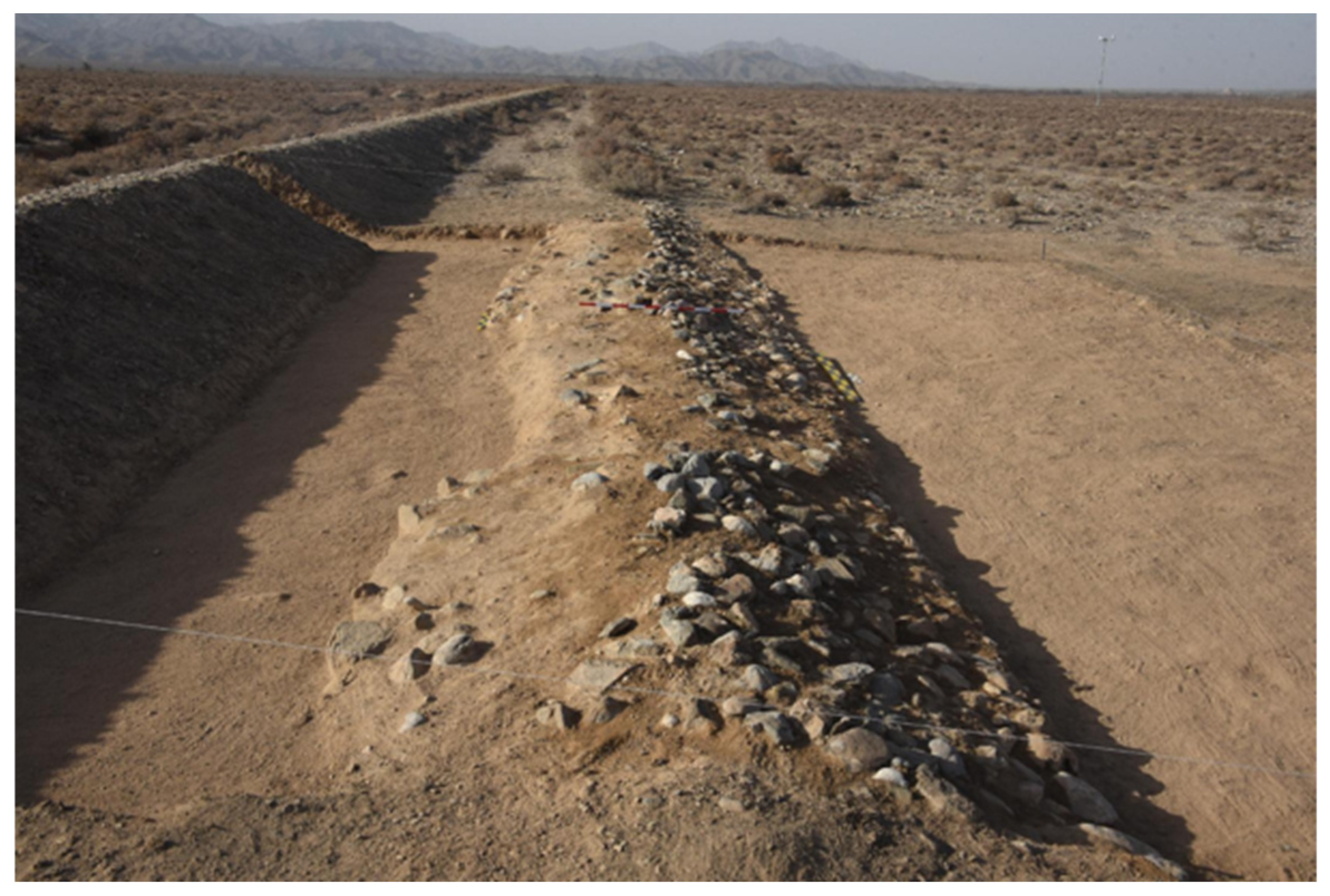
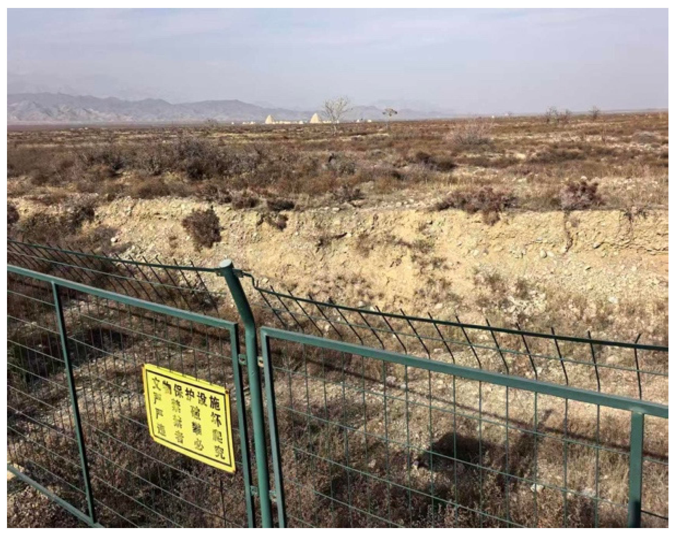
Despite their significance, these flood control facilities—constructed precisely in areas subject to severe erosion—received limited attention during the early stages of archeological research at the Xixia Imperial Tombs. As a result, many flood control walls and drainage channels fell into a state of deterioration, gradually losing their defensive function against flooding (Figure 5).
In 2024, the Ningxia Institute of Cultural Relics and Archeology carried out archeological excavations at three flood control engineering sites within the Xixia Imperial Tombs, including several old and new flood control walls. As shown in Figure 6, the old flood control wall can be traced back to the Xixia period, but it has been seriously degraded due to long-term exposure and historical use. According to the protection principle of minimum intervention and respect for the authenticity of the site, a new flood control wall was built near the original structure. This intervention aimed to restore the functional capacity of the flood control system while preserving the original appearance and spatial integrity of the heritage site to the greatest extent possible [20].

Author’s Field Assessment of Existing Flood Control Structures

To complement the archival and excavation records, the author conducted systematic field observations of 21 flood control structures across Areas I, II, III, and IV of the Xixia Imperial Tombs between 2024 and 2025. Each structure was assessed for its physical condition, evident damage patterns, and apparent functionality during recent flood events (particularly the 2020 flash flood). Table 1 summarizes the assessment results.
The field assessment revealed three critical findings. First, approximately 40% the surveyed ancient facilities exhibited moderate to severe deterioration, with 20% classified as completely collapsed or beyond functional recovery (e.g., QII-07). Second, only half of the well-preserved structures had documented intervention records, suggesting that most maintenance has been ad hoc and undocumented. Third, several unrecorded local repairs, highlight the absence of a systematic maintenance log. These findings underscore the need for a comprehensive inventory and condition check system for all 32 flood control structures at the site.
In 2020, an intense rainfall event triggered a sudden flash flood in the Helan Mountains, resulting in extensive damage to both natural ecosystems and cultural heritage sites in the region. In particular, the rock art sites of the Helan Mountains suffered severe damage. Owing to their unique geological and material characteristics, these rock paintings are inherently irreplaceable, and the flood caused irreversible losses, including surface rupture, exfoliation, and partial disappearance. Although the Xixia Imperial Tombs were not directly affected by this flash flood—largely due to the presence of flood control canals and flood control walls—the event nevertheless underscores the limitations of relying solely on engineering measures for cultural heritage protection. As the field assessment above demonstrates, many ancient structures are already compromised, and without systematic monitoring and maintenance, their protective function cannot be guaranteed for future extreme events.

6. The Establishment of a Technology-Based Preventive Conservation System

6.1. The Concept of “Preventive Conservation”

UNESCO has emphasized that disaster risks to cultural heritage arise from both external and internal factors. External factors include sudden destructive events such as typhoons, tsunamis, and armed conflict, which can directly damage heritage assets. Internal factors, by contrast, relate to the inherent fragility of heritage structures and materials, as well as their sensitivity to environmental conditions [9].
The Xixia Imperial Tombs and the Mogao Grottoes in Dunhuang are both situated in northwestern China and face similar environmental challenges, including sandstorms, precipitation, intense solar radiation, and significant temperature fluctuations. Consequently, the two sites share notable commonalities—and potential complementarities—in their conservation philosophies, technical approaches, and management strategies. The Dunhuang Academy has long maintained international cooperation with the Getty Research Institute in the field of heritage conservation and has played a pioneering role in introducing and advancing the concept of “preventive conservation” in China. This approach shifts the focus away from passive, post-damage restoration toward proactive, continuous monitoring and environmental control aimed at slowing the deterioration of cultural heritage.
At the Xixia Imperial Tombs, the core conservation challenge lies in the coexistence of a long-term arid climatic background and episodic but severe flood hazards, combined with the extreme fragility and non-renewable nature of the heritage fabric. In response and informed by the preventive conservation practices developed at Dunhuang, the protection strategy for the Xixia Imperial Tombs has gradually evolved from a predominantly rescue-oriented model to one centered on prevention, risk anticipation, and long-term environmental management.

6.2. Intelligent Monitoring System Empowered by Science and Technology

Since 2017, conservation efforts at the Xixia Imperial Tombs have entered a new phase, with “preventive conservation” adopted as the core strategic principle. As part of this transition, a dynamic site information, monitoring and early warning system was gradually introduced into site management. In 2024, this system was comprehensively upgraded to the Xixia Imperial Tombs Heritage Monitoring and Early Warning Platform, significantly enhancing the precision of site protection and strengthening preventive conservation capacities through the application of advanced technologies [21,22].
According to the platform’s technical documentation and a report by the Science and Technology Daily [21,22], the system integrates various technologies such as the Internet of Things (IoT), unmanned aerial vehicles (UAVs), satellite remote sensing, manual inspection, and mobile applications, establishing a comprehensive monitoring network that covers the heritage structures. This system enables closed-loop management, from continuous monitoring and risk identification to proactive prevention. This “preventive conservation” paradigm reflects the mainstream shift in the international field of cultural heritage risk management from passive response to active intervention [3] and serves as a concrete example of how digital technologies are empowering heritage conservation to move beyond documentation towards intelligent risk management [10]. Using satellite remote sensing and three-dimensional modeling technologies, the platform conducts comprehensive monitoring of the 9 imperial mausoleums, 271 subordinate burials, and associated heritage features.
Beyond documenting gradual deterioration processes—such as weathering, erosion, and surface denudation of mausoleum towers—the system integrates environmental data to support accurate disaster early warning. By combining heritage condition monitoring with meteorological and soil-related parameters, the platform establishes a complete “monitoring–early warning–response” cycle. Real-time data updates include structural parameters (e.g., soil temperature, soil moisture content, displacement, and settlement) as well as environmental indicators such as air temperature, precipitation, and wind speed. When monitored values exceed predefined thresholds, alerts are automatically transmitted to conservation personnel via the mobile application, enabling timely intervention and adaptive management.
The Xixia Imperial Tombs have established a comprehensive protection system that integrates traditional conservation approaches with modern management and technological innovation. In terms of legal and institutional frameworks, a three-tier protection mechanism—encompassing the state, the Ningxia Hui Autonomous Region, and Yinchuan City—has been formed. Key regulatory and planning documents, including the Regulations on the Protection of the Xixia Imperial Tombs in Yinchuan and the Protection Plan for the Xixia Imperial Tombs (2019–2035), provide a clear legal basis and long-term strategic guidance for conservation practice.
At the administrative level, the Yinchuan Xixia Imperial Tombs Management Office was established, supported by a professional conservation team of more than 160 staff members. The management body has also engaged in sustained technical cooperation with leading national heritage institutions, such as the Dunhuang Academy and the Palace Museum, to strengthen conservation capacity and knowledge exchange. Regarding the protection of the heritage fabric, temporary structural support measures have been implemented since 1986 in areas exhibiting severe deterioration, particularly in unstable rammed earth structures, alongside the construction and reinforcement of flood control facilities. Between 2000 and 2017, 9 imperial mausoleums and 44 subordinate burials were structurally reinforced. For example, Mausoleum No. 3 was stabilized using anchor rod reinforcement, while Mausoleum No. 6 was protected through masonry-based stabilization techniques [23].
Since 2018, a preventive conservation system driven by scientific and technological innovation has been progressively developed. In 2024, the new Xixia Imperial Tombs Monitoring Center was completed and put into operation. This facility enables real-time monitoring of 99 key indicators, including parameters related to weathering, humidity, temperature, and precipitation. In parallel, the digitization of movable and immovable cultural relics has been advanced, with three-dimensional data collected for 380 registered cultural relics. Importantly, flood control measures within the mausoleum complex have been systematically integrated with Yinchuan’s urban flood control system, enhancing the site’s overall resilience to hydrological risks.
In terms of financial support, sustained funding has been provided through special allocations from the central government, the autonomous regional government, and Yinchuan City. Notably, the Regulations on the Protection of the Xixia Imperial Tombs in Yinchuan formally incorporate conservation funding into the municipal fiscal budget, ensuring long-term financial stability and institutional support for ongoing and future protection efforts.

7. Discussion

The findings of this study underscore the critical importance of integrating flood risk management into the conservation strategies for cultural heritage in arid regions, particularly in the context of increasing climate variability. The Xixia Imperial Tombs serve as a compelling example of how traditional flood control infrastructure, while historically effective, must now be augmented with modern risk governance approaches to address the intensifying threats posed by climate change. Rather than reiterating general recommendations, this discussion focuses on four specific tensions and gaps identified through the author’s field assessment and archival analysis, organized within a multidimensional evaluation framework (Table 2).

7.1. The Persistent Gap Between Monitoring Capability and Response Action

The XIT Heritage monitoring and Early warning Platform (established 2024) represent a significant technological advancement, integrating IoT, UAV, satellite remote sensing, and mobile applications. However, technological capacity alone does not guarantee risk reduction. During the author’s interviews with site management staff (September 2024), it was revealed that while the platform generates automated alerts when soil moisture or precipitation thresholds are exceeded, there is no standardized protocol for what constitutes a “response” or how response effectiveness is documented. This gap between monitoring and action mirrors a broader problem identified in the Czech Republic by Holický and Sýkora [8], where inadequate communication among stakeholders—rather than lack of data—was the primary cause of heritage damage during floods. For the Xixia Imperial Tombs, the next critical step is not additional sensors, but the development of a response protocol that specifies evacuation, temporary shoring, or water diversion procedures for different alert levels.

7.2. The Unresolved Tension Between “Minimum Intervention” and Functional Necessity

The construction of a new flood control wall adjacent to the deteriorated ancient wall (Figure 6) exemplifies a recurring dilemma in heritage conservation: how to balance the ICOMOS principle of “minimum intervention to significant fabric” [3] with the functional necessity of protecting the site from recurring flood hazards. The author’s field assessment noted that the new wall is visually distinguishable from the ancient fabric—a design choice consistent with the Venice Charter’s requirement that modern additions be recognizable. However, a more difficult question remains unanswered: does the presence of the new wall alter the hydrological behavior of the alluvial fan in ways that could accelerate deterioration of nearby unexcavated remains? At present, no hydrological impact assessment has been conducted for this intervention. Drawing a cautionary lesson from the Mogao Grottoes, where afforestation unintendedly increased mural deterioration [14], the Xixia Imperial Tombs would benefit from a pre-intervention hydrological modeling requirement for any future flood control construction.

7.3. The Compound Risk of “Drought-Desertification-Sudden Flooding” and Its Implications for Monitoring Thresholds

This study confirms Berenfeld’s observation [13] that cultural heritage in arid regions is exposed to a compound risk cycle, in which prolonged drought hardens the soil surface and reduces infiltration capacity, such that when rare but intense storms occur, increased surface runoff generates gully erosion and transports soluble salts into the rammed earth fabric, with subsequent salt crystallization during dry periods, progressively weakening the earthen structures. Although the monitoring platform at the Xixia Imperial Tombs tracks soil moisture content, the threshold values used to distinguish “normal” from “dangerous” moisture levels appear to be generic rather than calibrated specifically for the unique material properties of the Xixia-period rammed earth. Based on the material analysis by Meng [19], which identified a lime-and-gravel mix in the rammed earth of Mausoleum No. 3, the optimal moisture range for this specific earthen composite may differ substantially from that of natural soils or other rammed earth sites. Consequently, establishing material-specific moisture thresholds for the Xixia rammed earth should be a research priority, requiring close collaboration between heritage scientists and conservation engineers to develop empirically grounded risk indicators for this distinctive earthen heritage.

8. Conclusions

Flood control infrastructure and risk management are of critical importance to the conservation of the Xixia Imperial Tombs. Although the site is located in an arid desert region, its position on an alluvial fan at the eastern foothills of the Helan Mountains exposes it to significant risks from sudden mountain torrents during the summer rainy season. This vulnerability is further intensified by the rammed earth construction of the mausoleums, which is highly susceptible to irreversible damage caused by the combined effects of salt crystallization and flood erosion. The 32 flood control structures constructed during the Xixia period embody the historical ingenuity of ancient water management practices; however, under contemporary conditions characterized by increasing climate variability, traditional engineering measures alone are insufficient.

8.1. A Three-Layer Framework for Arid-Region Heritage Flood Management

Synthesizing the findings from the Xixia Imperial Tombs with the broader literature, this study proposes a transferable three-layer framework for flood risk management at cultural heritage sites in arid regions. (1) The first historical layer involves documenting, assessing, and where possible, preserving ancient flood control structures as part of the heritage itself. Their continued function should be tested through systematic condition assessment. At the Xixia Imperial Tombs, the author’s field survey revealed that approximately 40% of the 21 surveyed structures exhibited moderate to severe deterioration, yet no comprehensive inventory or condition grading system currently exists. (2) The second technical layer requires implementing “monitoring-early warning-response” protocols that link automated alerts to actionable procedures. The XIT Heritage Monitoring and Early Warning Platform (2024) represents significant progress on data collection, but the threshold values for soil moisture remain generic rather than calibrated for the lime-and-gravel rammed earth composite identified at Mausoleum No. 3. Furthermore, a documented gap persists between alert generation and documented emergency response. (3) The third institutional layer entails embedding heritage flood management into regional control planning, securing dedicated budget lines, and formalizing cross-sector coordination through legally binding agreements. The inclusion of conservation funding in the municipal fiscal budget through the Regulation on the Protection of the Xixia Imperial Tombs provides a model of financial sustainability. However, no funds are specifically allocated to flood control facility maintenance, and the frequency of joint drills between heritage, water, and meteorological authorities remains undocumented.

8.2. From Reactive Repair to Preventive Conservation

This framework operationalizes the paradigm shift from reactive, post-disaster restoration toward proactive preventive conservation. For the Xixia Imperial Tombs, this shift requires: (a) completing a systematic condition assessment of all 32 ancient flood control structures (Layer 1); (b) calibrating monitoring thresholds specifically for the Xixia rammed earth composite and developing written response protocols for each alert level (Layer2); and (c) formalizing cross-sector agreements with water resources and meteorological agencies while creating a dedicated budget line for flood facility maintenance (Layer3).

8.3. Future Research Directions

This study has several limitations. First, the field assessment covered 21 of 32 flood control structures; a complete survey of all facilities is needed. Second, the analysis of monitoring-response closure relied on staff interviews rather than a systematic review of alert logs, which were not accessible for this study. Third, the proposed framework requires validation on other arid-region heritage sites to assess its transferability. Fourth, the limited funding constrained the scope of the field assessment and limited access to certain site management data, such as complete alert logs and real-time monitoring records. This limitation is acknowledged as a factor affecting the generalizability of the findings.
Future research should prioritize: (1) establishing material-specific moisture thresholds for the Xixia rammed earth through laboratory testing of core samples; (2) conducting a pre-and post-intervention hydrological impact assessment for new flood control constructions, learning from the unintended consequences documented at the Mogao Grottoes [14]; and (3) developing a standardized protocol for documenting and evaluating flood response actions to close the monitoring-action gap identified in this study.

8.4. Broader Implications

As extreme weather events become more frequent under climate change, the misconception that “arid regions are free from flood risks” while clearly contradicted by annual catastrophic flood events in some arid regions must be urgently reconsidered in the context of heritage conservation planning. The experience of the Xixia Imperial Tombs offers a valuable reference for the protection of cultural heritage in arid and flood-prone environments both within China and globally. By integrating engineering and non-engineering measures, supported by technology-enabled monitoring and robust institutional framework, long-term resilience can be achieved for irreplaceable heritage in the world’s most fragile environments.

Author Contributions

Conceptualization, R.Z. and C.K.; methodology, R.Z.; investigation, R.Z.; resources, R.Z.; data curation, R.Z.; writing—original draft preparation, R.Z.; writing—review and editing, C.K.; visualization, R.Z.; supervision, C.K. All authors have read and agreed to the published version of the manuscript.

Funding

This work was supported by 2026 Hongik University Innovation Support Program Fund.

Data Availability Statement

No new data were created or analyzed in this study. Data sharing is not applicable to this article.

Conflicts of Interest

The authors declare no conflicts of interest.

Correction Statement

This article has been republished with a minor correction to the Funding statement. This change does not affect the scientific content of the article.

References

  1. UNESCO. Xixia Imperial Tombs; Nomination Dossier for Inscription on the World Heritage List; UNESCO World Heritage Centre: Paris, France, 2025. [Google Scholar]
  2. Nobile, E.G.L.; Figueiredo, R.; Arrighi, C.; Romão, X.; Martina, M.L.V. Flood Risk Assessment of Cultural Heritage across Countries and Spatial Scales. Int. J. Disaster Risk Reduct. 2025, 118, 105236. [Google Scholar] [CrossRef] [Scilit]
  3. International Council on Monuments and Sites. Guidelines on Risk Management for Cultural Heritage; ICOMOS: Paris, France, 2010. [Google Scholar]
  4. Sesana, E.; Gagnon, A.S.; Ciantelli, C.; Cassar, J.; Hughes, J.J. Climate Change Impacts on Cultural Heritage: A Literature Review. WIREs Clim. Change 2021, 12, e710. [Google Scholar] [CrossRef] [Scilit]
  5. Orr, S.A.; Richards, J.; Fatorić, S. Climate Change and Cultural Heritage: A Systematic Literature Review (2016–2020). Hist. Environ. Policy Pract. 2021, 12, 434–477. [Google Scholar] [CrossRef] [Scilit]
  6. European Parliament and Council of the European Union. Directive 2007/60/EC of the European Parliament and of the Council of 23 October 2007 on the Assessment and Management of Flood Risks. Off. J. Eur. Union 2007, L288, 27–34. [Google Scholar]
  7. Mysiak, J.; Testella, F.; Bonaiuto, M.; Carrus, G.; De Dominicis, S.; Ganucci Cancellieri, U.; Firus, K.; Grifoni, P. Flood Risk Management in Italy: Challenges and Opportunities for the Implementation of the EU Floods Directive (2007/60/EC). Nat. Hazards Earth Sys. Sci. 2013, 13, 2883–2890. [Google Scholar] [CrossRef] [Scilit]
  8. Holický, M.; Sýkora, M. Assessment of Flooding Risk to Cultural Heritage in Historic Sites. J. Perform. Constr. Facil. 2010, 24, 432–438. [Google Scholar] [CrossRef] [Scilit]
  9. Wang, J.-J. Flood Risk Maps for Cultural Heritage: Measures and Process. J. Cult. Herit. 2015, 16, 210–220. [Google Scholar] [CrossRef] [Scilit]
  10. Mendoza, M.A.D.; De La Hoz Franco, E.; Gómez Gómez, J.E. Technologies for the Preservation of Cultural Heritage—A Systematic Review of the Literature. Sustainability 2023, 15, 1059. [Google Scholar] [CrossRef] [Scilit]
  11. Boboc, R.G.; Băutu, E.; Gîrbacia, F.; Popovici, N.; Popovici, D.-M. Augmented Reality in Cultural Heritage: An Overview of the Last Decade of Applications. Appl. Sci. 2022, 12, 9859. [Google Scholar] [CrossRef] [Scilit]
  12. Laguna-Palma, D.; Toscano, M.; Rodríguez-Rellán, C. The Role of Aerial Prospection for Monitoring and Preserving Cultural Heritage in Northeastern Africa. Heritage 2024, 7, 652–666. [Google Scholar] [CrossRef] [Scilit]
  13. Berenfeld, M.L. Climate Change and Cultural Heritage: Local Evidence, Global Responses. Georg. Wright Forum 2008, 25, 66–82. [Google Scholar]
  14. Qu, J.; Cao, S.; Li, G.; Niu, Q.; Feng, Q. Conservation of Natural and Cultural Heritage in Dunhuang, China. Gondwana Res. 2014, 26, 1216–1221. [Google Scholar] [CrossRef] [Scilit]
  15. Wang, Y.M. The Geographical Basis of the Xixia Dynasty’s Establishment of Capital at Xingqing Prefecture. In Studies on Ancient Chinese Capitals; Zhejiang People’s Publishing House: Hangzhou, China, 1985. [Google Scholar]
  16. Xu, Z.; Wang, Y. Xixia Royal Hunting Activities in Helan Mountains. J. Northwest Univ. Natl. 1986, 2, 45–52. [Google Scholar]
  17. Zhang, Y.; Liu, T. Interpreting the Spatial Pattern of the Xixia Imperial Tombs Using a Four-Step Method. China Cult. Herit. 2021, 6, 97–104. [Google Scholar]
  18. Wang, C.; Wang, H. An Analysis of the Site Selection of the Xixia Imperial Tombs Based on Historical Records. J. Ningxia Norm. Univ. 2021, 4, 79–82. [Google Scholar]
  19. Meng, F. Research on the Layout and Form of the Xixia Imperial Tombs. Palace Mus. J. 2012, 1, 56–95. [Google Scholar]
  20. Ningxia Institute of Cultural Relics and Archaeology. Archaeological Excavation Brief of Flood Control Works Sites at the Xixia Imperial Tombs; Unpublished Report; Ningxia Institute of Cultural Relics and Archaeology: Yinchuan, China, 2024. [Google Scholar]
  21. Xixia Imperial Tombs Management Office. Xixia Imperial Tombs Heritage Monitoring and Early Warning Platform: Technical Specifications and Operational Manual; Xixia Tombs Management Office: Yinchuan, China, 2024. [Google Scholar]
  22. Wang, Y. Technology Empowers the Xixia Imperial Tombs to Tell Millennia-Old Stories. 2025. Available online: https://www.stdaily.com/web/gdxw/2025-07/18/content_371708.html (accessed on 23 April 2026).
  23. Chinese Institute of Architectural Design & Research Co., Ltd.—Institute of Architectural History; Yinchuan Xixia Mausoleum Area Management Office; Ningxia Hui Autonomous Region Institute of Cultural Relics and Archaeology. Xixia Mausoleum Conservation Plan (2019–2035); Planning Document; Chinese Institute of Architectural Design & Research Co., Ltd.: Shanghai, China, 2020. [Google Scholar]
Figure 1. The aerial view of Mausoleum No. 3 at the Xixia Imperial Tombs. (Source: [1]: p. 2).
Heritage 09 00168 g001
Figure 2. Topographic Map of Xixa Imperial Tombs and Showing the Boundary of the Nominated Property. (Source: [1]: 11).
Heritage 09 00168 g002
Figure 3. (a) Map showing the remains in Area I and II. (b) Map showing the remains in Area III and IV. (Source: [1]: 26–29).
Heritage 09 00168 g003
Figure 4. (a) Overall picture of the rammed earth building of No. 3 Mausoleum Tower. (b) Local detail of rammed soil layer in No. 3 Mausoleum. (photo by author).
Heritage 09 00168 g004
Figure 5. Section of Original (Xixia-period) Flood Drainage Ditch at the Xixia Imperial Tombs. (Photo by author).
Heritage 09 00168 g005
Figure 6. Outside the No. 4 Mausoleum, the remains of the old flood control wall (on the right) and the new flood control wall (on the left). (Photo by author).
Heritage 09 00168 g006
Table 1. Condition Assessment of Selected Flood Control Structures at the Xixia Imperial Tombs (author’s field survey, 2024–2025).
Facility IDAreaTypeOriginal PeriodCurrent Physical ConditionFunctioned in the 2020 Flood? Intervention RecordAuthor’s Assessment and Recommendation
QI-01Area IControl WallXixiaPartially collapsed; longitudinal cracks in the middle section; vegetation intrusionUndeterminedNone documentedUrgent structural reinforcement; prioritize for the monitoring platform
QI-02Area IControl WallXixiaWell-preserved; surface weathering only Yes (per local staff)Local repair in 2021Routine maintenance sufficient
GI-01Area IDrainage ChannelXixiaSeverely silted; channel alignment indistinct; partially buried by sandNoNoneArcheological cleaning is needed to assess the original drainage capacity
QII-03Area IIControl WallXixiaLargely intact; minor settlement on the western sectionYesReinforced in 2019Include in regular patrol; no major intervention needed
QII-07Area IIControl WallXixiaCompletely collapsed; only foundation traces remainNoNonePreserve as exposed ruins; construct a new wall elsewhere following the minimum intervention principle
2024-XL-01Area IVNew Control Wall2024 (modern)Intact; not yet tested by floodN/A (post-2020)Newly built in 2024Long-term monitoring is needed for hydrological impact and landscape authenticity
QIII-05Area IIIControl WallXixia3 m breach in the middle section from flood scouring; gullies on both sides Partial Emergency rockfill in 2023Archeological documentation prior to repair; add upstream diversion structures
Table 2. Multidimensional Assessment Framework for Flood Risk Management at the Xixia Imperial Tombs (author’s construction).
DimensionIndicatorCurrent Status (Based on Field Observation and Archives)Identified Gap/ProblemAuthor’s Recommendation
Engineering MeasuresIntegrity rate of ancient flood structures ~60% well-preserved, 20% partially collapsed, 20% severely damaged/lost among 21 surveyed structuresNo systematic inventory or condition check standard existsEstablish a “Flood Control Heritage Inventory” with a 5-year review cycle
Engineering Measures Adaptability of new structuresNew wall (2024-XL-01) built not yet tested by extreme rainfallDesign standards may not account for increasing extreme precipitation frequency under climate changeRe-evaluate the design based on updated meteorological data
Monitoring and Early WarningReal-time coverage of flood structuresMonitoring platform covers 9 mausoleums and 271 burials; not individually sensor-equipped for flood No displacement/seepage monitoring on control walls or channelsInstall low-cost displacement sensors on critical flood control walls
Monitoring and Early WarningWarning-response closurePlatform can push alerts to staff mobile appNo public data on how many alerts triggered actual emergency responsesEstablish “alert-disposal- feedback” log; evaluate response timeliness annually
Institutional SupportCross-sector coordination Integrated into the Yinchuan flood urban flood control systemUnknown frequency of data sharing and joint drills between heritage, water, and meteorological authoritiesFormalize inter-agency agreement; conduct at least one joint flood drill per year
Institutional SupportFinancial sustainabilityConservation funding included in municipal budget per regulations Unclear what proportion is specifically allocated to flood facility maintenanceCreate a separate line item for “flood control facility maintenance” in the annual budget
Authenticity/Minimal InterventionLandscape impact of new interventionsNew wall (2024-XL-01) placed adjacent to old wall (Figure 6); visual distinction is clearDoes this comply with ICOMOS “principle of recognizability”? Does it affect the visual integrity of the site? Use interpretive signage to clearly distinguish old vs. new as part of “contemporary conservation history”
Disclaimer/Publisher’s Note: The statements, opinions and data contained in all publications are solely those of the individual author(s) and contributor(s) and not of MDPI and/or the editor(s). MDPI and/or the editor(s) disclaim responsibility for any injury to people or property resulting from any ideas, methods, instructions or products referred to in the content.