
Article

Expansion of Tourism Infrastructure Can Be Beneficial for Geoheritage: Evidence from the Western Caucasus
by
Anna V. Mikhailenko
1 and
Dmitry A. Ruban
2,*
1
Department of Physical Geography, Ecology, and Nature Protection, Institute of Earth Sciences, Southern Federal University, Zorge Street 40, Rostov-on-Don 344090, Russia
2
Department of Management Technology in Tourism Industry, Institute of Tourism, Service and Creative Industries, Southern Federal University, 23-ja Linija Street 43, Rostov-on-Don 344019, Russia
*
Author to whom correspondence should be addressed.
Heritage 2026, 9(4), 156; https://doi.org/10.3390/heritage9040156
Submission received: 9 March 2026 / Revised: 12 April 2026 / Accepted: 20 April 2026 / Published: 21 April 2026

Abstract

Geoheritage is commonly regarded as an important natural resource for tourism, but the latter can be a factor of risk to the former. A case study in the Western Caucasus, where the rural area of Mountainous Adygeya hosts many geosites (including those that are globally and nationally ranked), sheds light on a novel dimension of the aforementioned nexus, namely benefits to geoheritage from expansion of tourism infrastructure. The latter has grown remarkably in the study area during the past fifteen years. A comparison of 25 geosites as they were in 2010 and 2025 indicates their changes, which can be treated as positive and negative effects of the expansion of tourism infrastructure. Particularly, it is established that this expansion was responsible for the creation of one geosite, the extension of three previously existing geosites, the specialists’ awareness of an additional object, as well as for the improved accessibility of 12 geosites. Several negative effects are also documented, but they are neither major nor widespread due to the superb local environmental management. This example demonstrates that the rapid expansion of tourism infrastructure in rural, geoheritage-rich areas can contribute to their sustainability and not only challenges it.

1. Introduction

Tourism exploits various natural and cultural resources, including those with heritage value. In the past decades, geoheritage has become an important resource for tourism, recreation, and related activities [1,2,3]. Moreover, a specific kind of tourism based on unique and scenic geological objects and landscapes, namely geotourism, has rapidly expanded and matured on an international scale [4,5,6]. The most common attractions of geotourism are geosites (e.g., rock exposures, peculiar landforms, places with active geomorphological processes, thermal springs, abandoned mining sites), geoparks, geodiversity spots, and geology-focused museums and exhibitions. Geofestivals, geofood, and even virtual geoexcursions are also related to geotourism. Nonetheless, one should note that geoheritage often exists in popular tourist destinations, and, thus, it is affected by the “usual” tourism (not geotourism).
Geoheritage management is seen as a highly diverse set of tools, initiatives, and tasks that are related to the conservation of geoheritage features, promotion of the knowledge of them, and various forms of exploitation (e.g., for research, education, and tourism purposes). Monitoring the state of geosites is an urgent task of geoheritage management [7]. Ferdowsi [8] considered the enhancement of geoheritage management in tourist destinations. Various effects of tourism on geoheritage and, particularly, geosites have already been investigated. Significant attention has commonly been paid to damage, vulnerability, and sustainable management of geosites. Particularly, Fuertes-Gutiérrez et al. [9] noted anthropogenic threats to geoheritage, including those from recreation and geotourist activities. Babikova et al. [10] proposed a quantitative approach to take into account such threats to geoheritage. In contrast, positive effects of tourism on geoheritage are yet to be studied systematically. Of special interest are negative and positive effects of infrastructure developments, which always accompany the growth of tourist destinations and raise sustainability-related questions [11,12,13,14,15]. One can easily imagine occasional damage of geosites by roads or cave disturbance by installation of metallic stairs. But are some positive effects possible?
The western part of the Greater Caucasus mountain chain is known as the Western Caucasus, and it hosts rich geoheritage represented in many geosites, some of which are ranked nationally and globally [16]. These geosites are concentrated in a relatively small area (~750 km2), which corresponds to a major Russian tourist destination, namely Mountainous Adygeya. This all-season destination attracts significant flows of tourists, and nature-based tourism, ecotourism, adventure tourism, sport tourism, religious tourism, and outdoor recreation have flourished there in the past fifteen years [17,18]. This area seems to be very suitable for a case study aimed at answering a major research question: whether the expansion of tourism infrastructure can benefit geoheritage. The present study addresses this question, and its objective is to document effects of the expansion of tourism infrastructure on the geosites of Mountainous Adygeya.
To present a balanced view, positive and negative effects of the expansion of tourism infrastructure are considered together. It should be stressed that general tourism infrastructure, not that specific to geotourism, is addressed. This study is based on numerous observations made during fifteen years of regular visits to the study area. The previous, standardized assessment of the considered geosites and their touristic importance [16] remains valid, and, thus, it is not repeated in this work. In other words, this study is not a standard inventory of the territorial geoheritage, but it addresses a novel and particular aspect of the latter. This aspect seems to be of general importance because of the above-mentioned biases in the knowledge. More generally, this work does not intend to argue that the expansion of tourism infrastructure is always good for geoheritage; its purpose is to demonstrate that positive effects may also exist.

2. Study Area

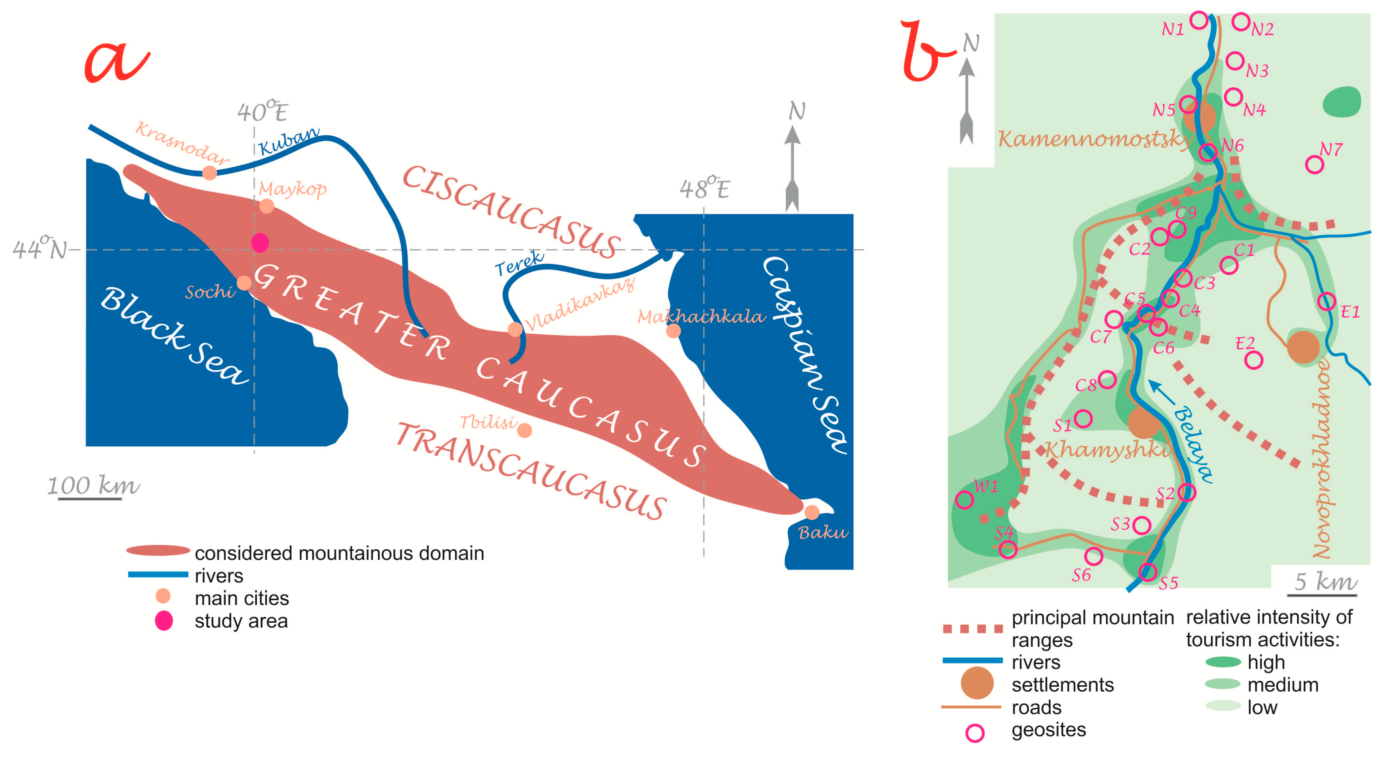
The study area, namely Mountainous Adygeya, represents the Russian South, and it is situated in the central part of the Western Caucasus (Figure 1a). This is a low-to-medium elevation mountainous domain with a temperate climate, very dense drainage network, and widespread forest vegetation. Its geological setting is complex and reflects the geological history from the Gondwanan affinity before the mid-Paleozoic to the back-arc basin evolution during the Mesozoic–early Cenozoic and the young orogen growth in the late Cenozoic; Jurassic sedimentary deposits are most common, and they were tectonically distorted (folded, faulted, and inclined) [19,20,21]. The area represents a broad spectrum of geological and geomorphological features, many of which are unique (peculiar rocks, important fossil and mineral localities, megaclast accumulations, karst and pseudokarst, inverted landforms, cuestas, waterfalls, etc.).
The geoheritage of the study area has been reviewed by Karpunin et al. [22], Ruban et al. [16], and Volkodav et al. [23]. More than twenty geosites were proposed (Table 1). Their descriptions and geological contexts were presented in the works cited above. The majority of the geosites are concentrated in the valleys of the Belaya River and its tributaries, and a few important geosites from the southwestern edge of the area are linked to the Lagonaki Highland (Figure 1b). The local geosite inventory started near the end of the 1990s [22], culminated in the 2010s–early 2020s [16,23], and continues gradually up to nowadays. The context of these geosites differs (many are geomorphological, paleontological, and sedimentary), and two of them are ranked globally (Table 1). Several geosites like the Granite Gorge and Sakhray are related to the protected areas designated by the regional government, and the others do not have official status. The most in demand geosites are Lagonaki, Khadzhokh Canyon–Rufabgo, and Partisan Glade–Maple Glade, each with the number of visitors measured by hundreds on peak days. Nonetheless, many geosites exist in the areas with a high or medium intensity of tourist activities (Figure 1b).
Tourism has developed in Mountainous Adygeya since the mid-20th century, and it has accelerated remarkably in the past fifteen years (2010–2025). Although statistics are absent, tourist flows are measured in thousands of visitors per week (especially in July–September and during the winter, spring, and autumn holidays). Dozens of hotels and lodges have been constructed, and the overall tourism infrastructure (man-made attractions, high-class roads, hospitality enterprises) has experienced unprecedented growth in the first half of the 2020s and contributed to the socio-economic prosperity of the local, initially rural communities. The relative intensity of tourist activities differs across the study area, but many geosites are situated where this intensity is high or medium (Figure 1b).

3. Materials and Methods

Observations made during regular (yearly) visits to the study area and examinations of all geosites (Table 1) during 2010–2025 constitute the material of the present study. These observations, recorded with notes and photographs, can be used for subsequent analysis. Attention is paid to the materials representing the state of the geosites in 2010 and 2025; this time span marks the approximate beginning of the expansion of tourism infrastructure and its present culmination.
Positive and negative effects of the expansion of tourism infrastructure on the geoheritage of Mountainous Adygeya are established taking into account the contemporary understanding of geosites and their basic properties [16,24,25,26,27,28,29,30]. The general principles are as follows. By comparing the state of the geosites between 2010 and 2025, it becomes possible to document the changes. The changes which can evidently be attributed to the expansion of tourism infrastructure are distinguished, and their positive or negative essence is established regarding the conditions of the geosites. The information from the different geosites of the study area permits us to outline a few categories of these changes. Then, the presence of each category of changes, marking either positive or negative effects, can be checked in each geosite. The outcomes of such an analysis are then summarized. The frequency of each category of effects is measured. Moreover, the spatial distribution of the effects in Mountainous Adygeya is examined via visualization of their presence in the geosites. The degree, i.e., “depth” of the changes, is not taken into account to avoid too subjective judgments. In contrast, when only the presence/absence of a given effect is established for all of the geosites, the spatial distribution of this effect can be measured objectively as a share of the geosites with this effect among all considered geosites of the study area. The essence of the effects of the expansion of tourism infrastructure on geoheritage in the study area is characterized below.
The recorded positive effects of the expansion of tourism infrastructure in Mountainous Adygeya on its geoheritage are related to its growth, accessibility, and tourist demand. The infrastructural growth produces three principal effects, namely creation (appearance of new geosites due to infrastructural developments, chiefly road construction), extension (appearance of new geoheritage features that enlarge existing geosites), and detection (discovery of geoheritage features by tourists, with subsequent proposal of geosites by specialists). Accessibility is an important property of geosites, which can be outer and inner, i.e., the ease of reaching geosites and of moving within them, respectively (sensu [28]). Both forms of accessibility can be improved together with the expansion of tourism infrastructure.
The recorded negative effects of the expansion of tourism infrastructure in Mountainous Adygeya on its geoheritage include unauthorized overcollection of fossils, graffiti left by tourists on natural rocky slopes, trail expansion (multiplication, widening, and/or deepening of trails and associated changes), denaturalization of geosite views (due to constructions and elements of touristic infrastructure), and decreased accessibility (e.g., constructions limiting access to geological features). Neither physical destruction of geosites nor litter accumulation were recorded. Fossil overcollecting and graffiti on slopes are judged among the infrastructure-related effects because they are stimulated by the overall infrastructural growth in the study area.
As explained above, the presence of the noted effects in each geosite of the study area in 2010 and 2025 was determined. The procedures used in the present study are based on large-scale observations made in the field, and they are fully analytical. First, they are based on the categorization of effects. Second, they require detection of these effects in the geosites. Third, the frequency of these effects and their spatial distribution are analyzed. The simplicity of the procedures is only apparent because a huge amount of data from observations made during numerous field trips was employed. The documented distribution of the effects is the main outcome of this work, and the related information is summarized and exemplified.

4. Results

4.1. Positive Effects: Distribution and Selected Cases

The geoheritage of Mountainous Adygeya experienced significant changes between 2010 and 2025. Various benefits from the expansion of tourism infrastructure are recorded in twelve geosites (Table 2). The related changes are explained and exemplified below.
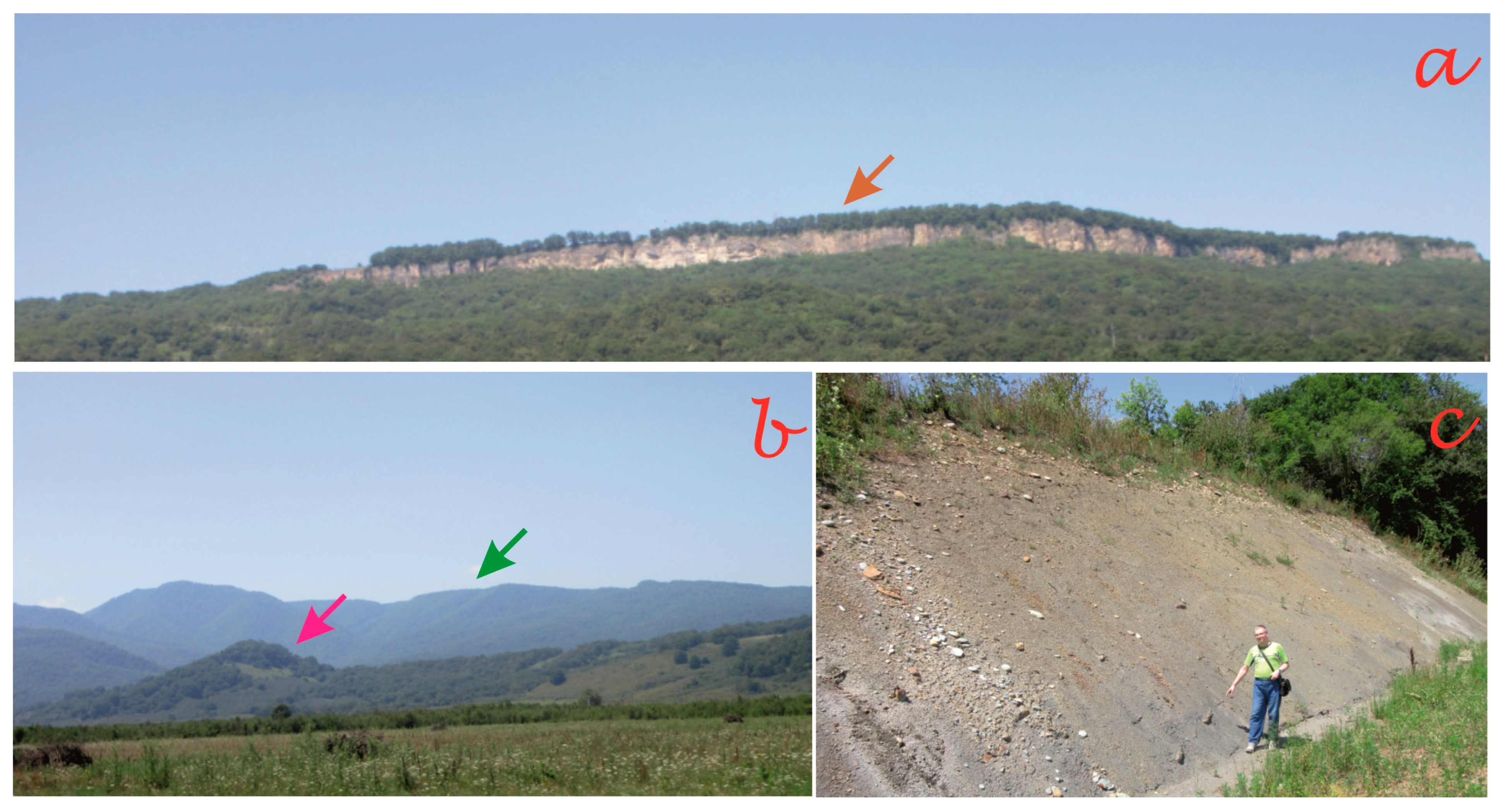
The growth of local geoheritage is registered in several geosites (Table 2), constituting a fifth of all geosites in this part of the Western Caucasus (Table 3). First of all, the creation of new attractions and the rapid development of the related infrastructure in the study area resulted in the emergence of the large Deguako Glade geosite in its centre (C9 in Table 1 and Figure 1b). A vast and flat space with meadows along the left bank of the Belaya River remained a kind of “blank spot” in the local tourism environment for many decades despite its outstanding scenery due to its very limited accessibility. The situation changed in the 2020s when an ambitious project was realized, and a high-class road stretching across this space was constructed. Regarding geoheritage, it was thought initially that the utility of this road was limited to improving accessibility to the Wildpig Mountain [28]. However, detailed field investigations carried out in July 2025 demonstrated that a large part of this road and its vicinities themselves can be proposed as a geosite (Table 2). On the one hand, 360° panoramic views of the peculiar landforms are available from many places on this road (Figure 2a,b). These views are not only highly spectacular, but also important from scientific and educational points of view. They are essential for the correct interpretation of such types of landforms as cuestas and inverted mountains, which are the focus of contemporary international geoscience research [31,32]. The views from the new road are more informative than from any other place. One should note that the availability of exceptional panoramic views of geological landscapes is a reasonable basis for the proposal of the so-called viewpoint geosites (sensu [33]). Moreover, new exposures of Lower–Middle Jurassic shales were found in lengthy road cuttings (Figure 2c), and these exposures provide a unique opportunity to decipher the local geological structure. It should be stressed that the Deguako Glade geosite is rather artificial; i.e., the road construction resulted in the appearance of entirely new, well-accessible viewpoints and outcrops (Table 2).
Extensions of the previously established geosite are more common (Table 3), and they are exemplified as follows. The tourism-related road maintenance carried out in the Lagonaki Highland and the construction of winter tourism facilities near the Maple Glade (W1 and S4 in Table 1 and Figure 1b) created a lengthy outcrop of uppermost Jurassic variegated deposits and an outstanding viewpoint for panoramic observation and distant scientific investigation of the geological landscape, respectively. In both cases, the previously established geosites benefited via the extension of their geological content and the appearance of fundamentally new attractions (Table 2).
In a single case, the previously unknown geosite was found (Table 3). The Oselkovy Waterfall geosite in the southern part of Mountainous Adygeya (S6 in Table 1 and Figure 1b), which includes a small waterfall and outcrops of Jurassic deep-marine shales, is a natural object located in a rather remote area with dense forests and abundant wildlife. It has become known thanks to the infrastructure improvement in the past decade. On the one hand, Guzeripl and the Partisan Glade became able to accommodate a bigger number of tourists who needed a greater number of attractions. On the other hand, the local development of hiking and adventure tourism raised people’s interest in remote but spectacular places. Subsequently, online reports of individual tourists in social media and advertisements distributed by hotels and lodges (these signify a growth of information infrastructure) made specialists aware of this notable object (Table 2).
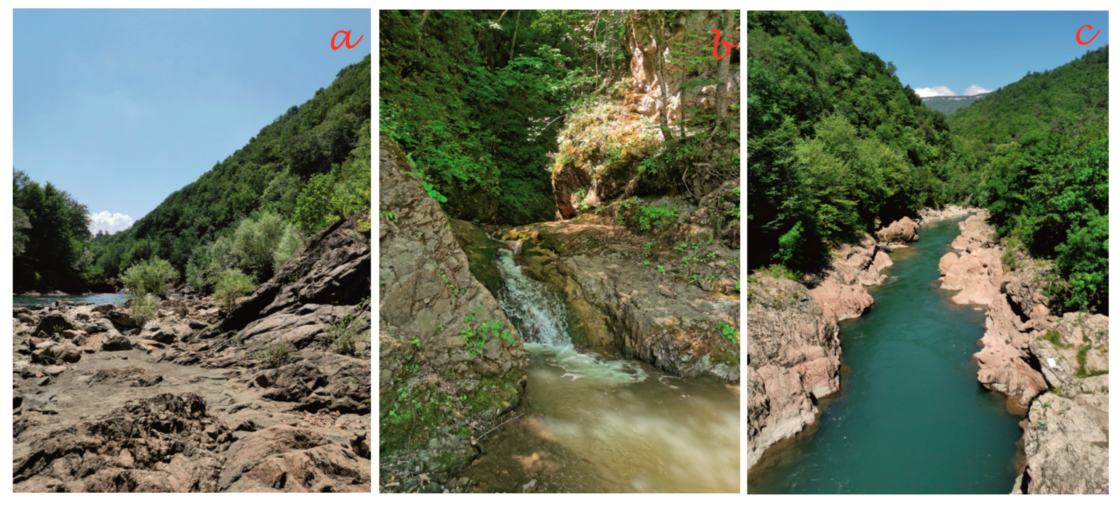
The outer and inner accessibility of about a half of the considered geosites has improved in the past fifteen years (Table 3). The changes were more common regarding outer accessibility (Table 3), and both outer and inner accessibility of the same geosites were improved in a few cases (Table 2). These transformations were caused chiefly by the active maintenance and construction of roads, as well as the multiplication of trails. Three examples are as follows. The Fissure Waterfall, as the most attractive locality of the large Sakhray geosite (E1 in Table 1 and Figure 1b), is connected with the closest settlement by a lengthy (>5 km) unpaved road, the very poor quality of which seriously limited its outer accessibility. The situation changed significantly after the maintenance of this road in 2024–2025. The construction of a new hotel near this geosite stimulated this maintenance, which promises to become regular. The Sibirka geosite (C7 in Table 1 and Figure 1b) hosts spectacular exposures of pre-Mesozoic crystalline rocks on the left bank of the Belaya River (Figure 3a) and a small but picturesque waterfall on the Sibirka River (Figure 3b). Their outer accessibility has increased significantly together with the improvement of the trail along the left bank of the river (Figure 3c), a part of which has become an unpaved road with a possibility for car parking. A third example can be found in the Lagonaki geosite (W1 in Table 1 and Figure 1b), where the inner accessibility of this globally ranked geosite, representing a highly unique, high-elevation karst environment, has improved after widening of trails, installing signs and explanatory panels, and creating places for outdoor recreation. Before 2010, tourists chiefly visited marginal parts of this very large geosite, although the most interesting (also for science and education) epikarst landforms and exposed Late Jurassic reefs are located in its internal parts. One should note that such features are very precious for geotourism and overall nature-based tourism [34,35]. The present infrastructure changes have made these features well accessible to visitors of the Lagonaki Highland.

4.2. Negative Effects: Distribution and Selected Cases

The changes experienced by the geoheritage of Mountainous Adygeya between 2010 and 2025 indicate several negative effects of the expansion of tourism infrastructure. They are recorded in a limited number of geosites (Table 4), their magnitude is small or very small in the majority of cases, and these effects do not substantially decrease the overall quality of the geosites. Physical destruction of geosites was found in no locality, and uncontrolled litter accumulation is almost absent due to the regular maintenance of roads and recreation spaces. More importantly, >60% of the considered geosites did not experience any negative effects from the expansion of tourism infrastructure in the past fifteen years (Table 5).
Several geosites of the study area are important fossil localities (Table 1). However, unauthorized collecting activities have impoverished only the Polkovnitskaya geosite (E1 in Table 1 and Figure 1b), where massive extraction of mid-Cretaceous ammonite shells by amateur paleontologists and fossil sellers has made specimens rare. Anyway, this kind of damage started a long time before 2010, and, apparently, the expansion of tourism infrastructure in the past 15 years increased it only slightly (Table 4).
The accessibility of 12% of geosites decreased (Table 5). In the case of the Khamyshki Section (S2 in Table 1 and Figure 1b), a tourism-triggered increase in traffic on the road, along which this section of Permian molassic red beds stretches, raised the question of safety due to occasional rock falls. The implemented engineering solution was to cover steep slopes with metallic nets protecting cars and hikers and minimizing the amount of debris delivered to the road. However, the nets also limit access to the exposed rocks and complicate their close examination and sampling. Taking into account the safety of visitors, such a negative effect can be judged acceptable. Moreover, the nets only complicate access to some features of this geosite, but they do not make them fully inaccessible. One should also note that the Partisan Glade–Maple Glade geosite (S4 in Table 1 and Figure 1b) experienced simultaneously increases (Table 2) and decreases (Table 4) in accessibility, which is explained by its large size and different directions of changes in its parts. Apparently, positive effects prevail over negative effects in this geosite.
Slightly more common are such effects as graffiti on slopes and trail expansion (Table 5). Related examples can be found in the Khadzhokh Canyon, the Lagonaki geosite, and the Khamyshki Section (N6, W1, and S2 in Table 1 and Figure 1b, respectively). Widening of trails damages vegetation, facilitates soil erosion, and triggers local rock polishing, and this tourism-related problem is known from some other geoheritage-rich places of the world [36,37]. In Mountainous Adygeya, this negative effect appears only very locally, i.e., on small plots of large geosites, and the latter do not become less informative or aesthetically attractive.
About a quarter of all geosites of the study area experienced denaturalization of their views due to tourism-related infrastructural development (Table 5). For instance, massive construction of lodges, car stops, and winter tourism facilities in some parts of the Partisan Glade–Maple Glade geosite (S4 in Table 1 and Figure 1b) has made the local landscapes look less wild and remote than they did before. However, one should consider that in this and other cases, where the views became less natural (Table 4), geological features were less affected than the surrounding landscapes. Moreover, the changed views reflect a shift from fully natural to touristic landscapes, not to fully anthropogenic landscapes.

5. Discussion

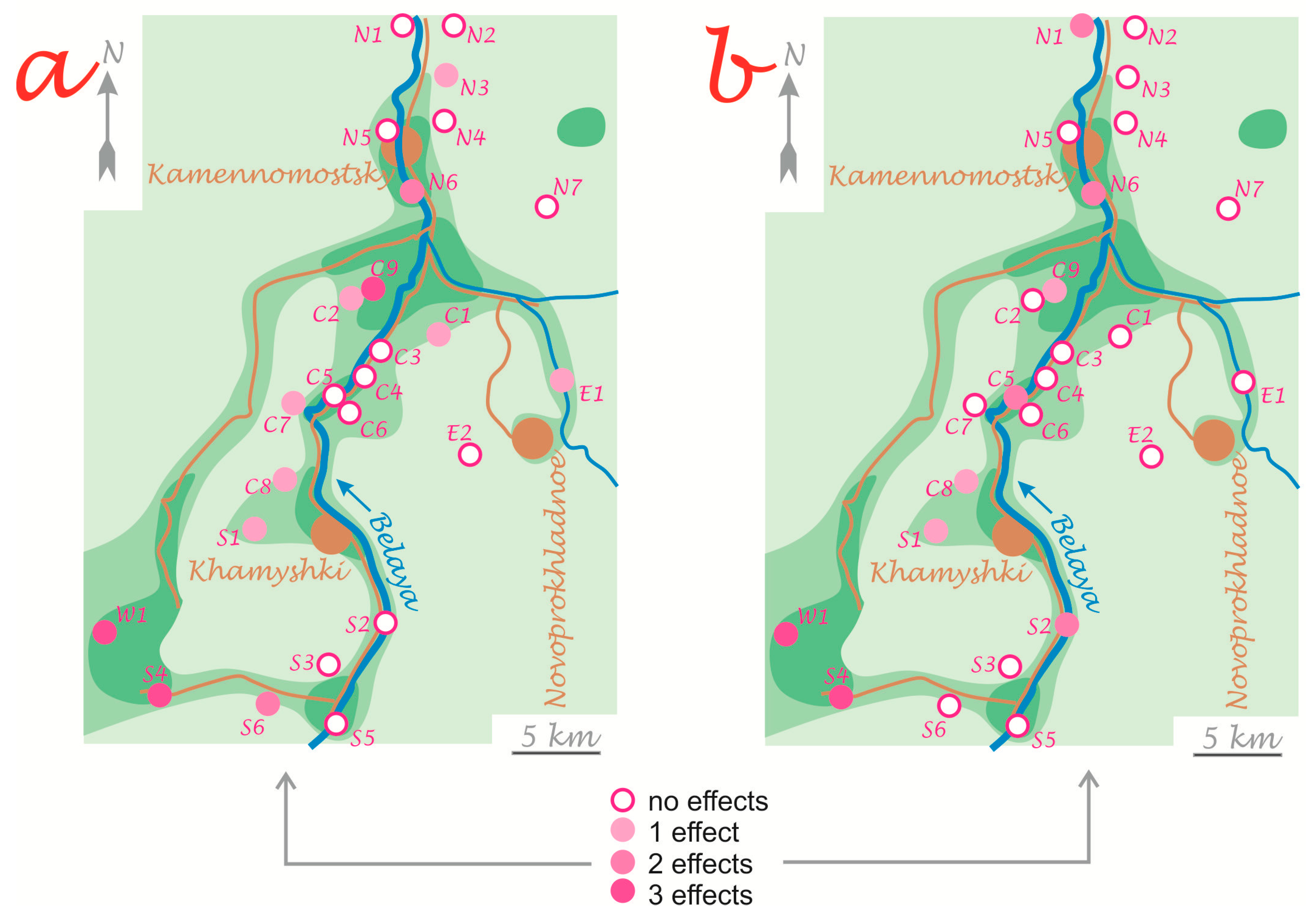
The results of this tentative analysis imply that the benefits of the expansion of tourism infrastructure for geoheritage are rather common in Mountainous Adygeya (Table 3). Various negative effects are also documented, but less frequently so (Table 5). Several geosites experienced both positive and negative changes, and the former often prevailed. Spatially, the effects are established everywhere and without sharp regularities. Nonetheless, one can note that a relatively high intensity of tourism activities is associated with a greater number of positive (Figure 4a) and negative (Figure 4b) effects, but this is not a strong “rule”.
Sustainable management of geoheritage is an important theme, both conceptually and practically [8,38,39,40,41,42,43]. Trade-offs between geoheritage conservation and tourism are debated [44,45]. Indeed, touristic exploitation of geoheritage resources can bring socio-economic benefits, but it also creates risks for geosites, which can be vandalized, occasionally damaged, littered, artificially reorganized, and depleted. The outcomes of the present work (Table 3 and Figure 4a) show that not only local communities, businessmen, and tourists, but also geoheritage itself can benefit from the expansion of tourism infrastructure. But what is the actual cost of such benefits? During the past 15 years, the study area turned from a rural area with almost pristine nature to a popular tourist destination with crowds of visitors and actively growing infrastructure. Attention to negative effects (Table 4) implies that they are not too common (Figure 4b). Apparently, environmental management and touristic planning implemented on national, regional, and municipal levels prevented or minimized the negative effects of the expansion of tourism infrastructure in Mountainous Adygeya. The sustainability of the geoheritage of the study area was not challenged; in contrast, it was enhanced by the registered benefits (Table 3).
Another interesting question is whether the expansion of tourism infrastructure and the registered benefits for the geosites stimulate local growth of geotourism (sensu stricto—e.g., see the definitions in [4,46,47,48,49]). In this regard, the observations made in 2010 and 2025 are identical, and they do not indicate any intensification of geotourist activities, which have remained elementary and limited as documented earlier by Ruban et al. [16]. One may hypothesize that geotourism depends on the greater public knowledge of geology and geomorphology.
The outcomes of the present study have three practical implications, as follows: First, geoheritage management in the study area should take into account geosite changes related to the expansion of local tourism infrastructure. Particularly, regular inventories are required to check whether new geosites have been unintentionally created or previously established geosites have been changed. Second, geoheritage management should not focus only on geotourism, and its scope should be widened to realize engagement of geosites into non-geological tourist activities. Third, active infrastructural growth creates some new opportunities for geological and geoheritage studies, and, thus, it is very reasonable to deepen collaboration between researchers in the noted field and representatives of the regional tourism industry and related authorities.

6. Conclusions

This tentative case study in the Western Caucasus implies that the expansion of tourism infrastructure may create various benefits for local geoheritage. Whether these benefits are more or less significant than the negative effects of tourism-triggered anthropogenic pressure depends on the efforts of various stakeholders responsible for tourism planning. More generally, the growth of tourist destinations creates sufficient premises for continuing exploration and exploitation of their geoheritage resources. The general importance of this study is related to the demonstration of the principal existence of some positive effects from the expansion of tourism infrastructure. Understanding the possible existence of such effects should enhance refinement of various tools employed in geosite inventories and territorial geoheritage assessments.
The main limitation of this work is that two important questions—the presence of positive effects and their coincidence with negative effects—are answered with a single example. This is enough for a pioneering study. However, benefits to geoheritage can be absent or lesser than negative changes in geosites in other growing tourist destinations. This means that similar studies in different places of the world are required. The other limitation is a rather descriptive approach. It appears to be enough to register the presence of positive and negative effects, but subsequent interpretations and developments require (semi-)quantitative tools, which are yet to be proposed. The principal research perspective is a development of comprehensive models for assessing positive and negative effects of tourism (not only infrastructural developments) for geoheritage and geosites.

Author Contributions

Conceptualization, D.A.R.; investigation, A.V.M. and D.A.R.; writing—original draft preparation, A.V.M. and D.A.R. All authors have read and agreed to the published version of the manuscript.

Funding

This research received no external funding.

Data Availability Statement

Data are contained within the article.

Conflicts of Interest

The authors declare no conflicts of interest.

References

  1. Migoń, P.; Pijet-Migoń, E. The role of geodiversity and geoheritage in tourism and local development. Geol. Soc. Spec. Publ. 2023, 530, 67–88. [Google Scholar] [CrossRef] [Scilit]
  2. Motalegh, F.R.; Ferdowsi, S. Evaluation of Management Interventions for Geoheritage Conservation in Tourism Destinations. Geoheritage 2024, 17, 48. [Google Scholar] [CrossRef] [Scilit]
  3. Nag, A. Revitalizing Mining Landscapes as Geoheritage Tourism Assets: Comparative Insights from Jharkhand and Rajasthan, India. J. Min. Environ. 2026, 17, 142. [Google Scholar]
  4. Hose, T.A. Geotourism Interpretation in the Southern Welsh Borderland Area. Geoheritage 2026, 18, 39. [Google Scholar] [CrossRef] [Scilit]
  5. Sarkar, A.; Gayen, S.K. Mapping the Field: A Systematic Bibliographic Review of Geotourism Trends in the Twenty-First Century. Geoheritage 2025, 17, 57. [Google Scholar] [CrossRef] [Scilit]
  6. Štrba, Ľ.; Vravcová, A.; Podoláková, M.; Varcholová, L.; Kršák, B. Linking Geoheritage or Geosite Assessment Results with Geotourism Potential and Development: A Literature Review. Sustainability 2023, 15, 9539. [Google Scholar] [CrossRef] [Scilit]
  7. Balaguer, L.P.; Garcia, M.D.G.M.; Santos, P.L.D.A. Geological Sites Monitoring Indicators: Systematic Review and Potential Application of Geoindicators. Geoheritage 2025, 17, 142. [Google Scholar] [CrossRef] [Scilit]
  8. Ferdowsi, S. Management of geoheritage conservation and vulnerability in tourism destinations. Tour. Rev. 2025, 80, 601–623. [Google Scholar] [CrossRef] [Scilit]
  9. Fuertes-Gutiérrez, I.; García-Ortiz, E.; Fernández-Martínez, E. Anthropic Threats to Geological Heritage: Characterization and Management: A Case Study in the Dinosaur Tracksites of La Rioja (Spain). Geoheritage 2016, 8, 135–153. [Google Scholar] [CrossRef] [Scilit]
  10. Babicová, Z.; Molokáč, M.; Pachinger, P.; Molitoris, L. Management of Geosites in Geoparks Based on the Quantitative and Potencial Threats Assessment: Example of the Emerging Zemplín Geopark. Geoheritage 2026, 18, 50. [Google Scholar] [CrossRef] [Scilit]
  11. Adey, P.; Lisle, D. Tourism infrastructures. Tour. Geogr. 2025, 27, 756–766. [Google Scholar] [CrossRef] [Scilit]
  12. Boers, B.; Cottrell, S. Sustainable tourism infrastructure planning: A GIS-supported approach. Tour. Geogr. 2007, 9, 1–21. [Google Scholar] [CrossRef] [Scilit]
  13. Quang, N.H. Perceptions of tourists and locals on tourism infrastructure and environmental protection in rural sustainable tourism. Int. J. Tour. Policy 2025, 15, 457–471. [Google Scholar] [CrossRef] [Scilit]
  14. Tang, R.; Sun, Y. Breaking the inverted U relationship between transportation infrastructure and tourism development provides new evidence for sustainability. Discov. Sustain. 2026, 7, 23. [Google Scholar] [CrossRef] [Scilit]
  15. Valánszki, I.; Fóris, E.D.; Kovács, K.F. Parallel development of green infrastructure and sustainable tourism—Case studies from Hungary. Pol. J. Nat. Sci. 2018, 33, 625–647. [Google Scholar]
  16. Ruban, D.A.; Mikhailenko, A.V.; Yashalova, N.N. Valuable geoheritage resources: Potential versus exploitation. Resour. Policy 2022, 77, 102665. [Google Scholar] [CrossRef] [Scilit]
  17. Bedanokov, M.K.; Chich, S.K.; Chetyz, D.Y. Ecological Tourism Development in the Republic of Adygea. Handb. Environ. Chem. 2020, 106, 573–602. [Google Scholar]
  18. Klimanova, O.A.; Bukvareva, E.N.; Yu, K.E.; Illarionova, O.A. Assessing ecosystem services in Russia: Case studies from four municipal districts. Land Use Policy 2023, 131, 106738. [Google Scholar] [CrossRef] [Scilit]
  19. Adamia, S.; Alania, V.; Chabukiani, A.; Kutelia, Z.; Sadradze, N. Great Caucasus (Cavcasioni): A long-lived North-Tethyan back-arc basin. Turk. J. Earth Sci. 2011, 20, 611–628. [Google Scholar] [CrossRef] [Scilit]
  20. Kolodyazhny, S.Y.; Kuznetsov, N.B.; Makhinya, E.I.; Shalaeva, E.A.; Dantsova, K.I.; Romanyuk, T.V.; Antipov, M.P.; Parfenov, G.E. Tectono-Gravitational Detachments in the Alpine Cover of the Northern Slope of the Greater Caucasus and Western Pre-Caucasus Basin (Adygean Segment). Geotectonics 2024, 58, 611–638. [Google Scholar] [CrossRef] [Scilit]
  21. Tawadros, E.; Ruban, D.; Efendiyeva, M. Evolution of NE Africa and the Greater Caucasus: Common Patterns and Petroleum Potential. In Proceedings of the Canadian Society of Petroleum Geologists, the Canadian Society of Exploration Geophysicists, the Canadian Well Logging Society Joint Convention, Calgary, AB, Canada, 15–18 May 2006; pp. 531–538. [Google Scholar]
  22. Karpunin, A.M.; Mamonov, S.V.; Mironenko, O.A.; Sokolov, A.R. Geological Monuments of Nature of Russia; Lorien: Sankt-Peterburg, Russia, 1998. (In Russian) [Google Scholar]
  23. Volkodav, I.G.; Volkodav, J.I.; Kazakov, O.A. Geological and Archaeological Monuments of Adygeya; Magarin: Maykop, Russia, 2024. [Google Scholar]
  24. Brilha, J. Inventory and Quantitative Assessment of Geosites and Geodiversity Sites: A Review. Geoheritage 2016, 8, 119–134. [Google Scholar] [CrossRef] [Scilit]
  25. Bruschi, V.M.; Cendrero, A. Geosite evaluation; can we measure intangible values? Alp. Mediterr. Quat. 2005, 18, 293–306. [Google Scholar]
  26. Ioannidi Galani, E.; Kati, M.; Drinia, H.; Voudouris, P. Geodiversity of Skyros Island (Aegean Sea, Greece): Linking Geological Heritage, Cultural Landscapes, and Sustainable Development. Land 2026, 15, 199. [Google Scholar] [CrossRef] [Scilit]
  27. Kim, D.; Kim, H. Definition and Scientific Value Assessment of Geosite from the Geopark Perspective: Application to the Hantangang River UNESCO Global Geopark (Main Geosites of Yeoncheon region). Econ. Environ. Geol. 2025, 58, 401–419. [Google Scholar] [CrossRef] [Scilit]
  28. Mikhailenko, A.V.; Ruban, D.A. Dynamic accessibility of geosites: Evidence from long-term observations in the Belaya River valley (western Greater Caucasus). Int. J. Geoheritage Parks 2025, 13, 306–318. [Google Scholar] [CrossRef] [Scilit]
  29. Pál, M.; Albert, G. Advancing Geosite Evaluation through Continuous Visitor-Centric Assessment. Geoheritage 2025, 17, 67. [Google Scholar] [CrossRef] [Scilit]
  30. Štrba, Ľ; Palgutová, S.B.; Derco, J.; Kršák, B.; Sidor, C. The Geotourism Product—What It Is and What It Is Not. Geosciences 2025, 15, 270. [Google Scholar] [CrossRef] [Scilit]
  31. Ba̧bel, M.; Olszewska-Nejbert, D.; Barski, M.; Bieńkowska-Wasiluk, M.; Głowniak, E.; Górka, M.; Jarzyna, A.; Kozłowska, M.; Leonowicz, P.; Łątka, T. Inverted relief and geoheritage values of the Leśna Hill (Holy Cross Mts.; Poland)—A re-evaluation of the underestimated geosite. Geomorphology 2025, 489, 109926. [Google Scholar] [CrossRef] [Scilit]
  32. Duszyński, F.; Migoń, P.; Strzelecki, M.C. Escarpment retreat in sedimentary tablelands and cuesta landscapes—landforms, mechanisms and patterns. Earth-Sci. Rev. 2019, 196, 102890. [Google Scholar] [CrossRef] [Scilit]
  33. Migoń, P.; Pijet-Migoń, E. Viewpoint geosites—values, conservation and management issues. Proc. Geol. Assoc. 2017, 128, 511–522. [Google Scholar] [CrossRef] [Scilit]
  34. Paliska, D.; Sedmak, G. Tourist Accommodation Choices in Nature-Based Destinations: The Case of Geotourism Destination Kras/Carso. Tour. Hosp. 2025, 6, 52. [Google Scholar] [CrossRef] [Scilit]
  35. Wakita, K.; Obara, H.; Oyama, N.; Murakami, T. Reassessing the Global Significance of Geological Heritage in the Miné-Akiyoshidai Karst Plateau Aspiring UNESCO Global Geopark. Geosciences 2025, 15, 56. [Google Scholar] [CrossRef] [Scilit]
  36. de Almeida Rangel, L.; do Carmo Oliveira Jorge, M.; Teixeira Guerra, A.J.; Fullen, M.A. Geotourism and Soil Quality on Trails Within Conservation Units in South-East Brazil. Geoheritage 2019, 11, 1151–1161. [Google Scholar] [CrossRef] [Scilit]
  37. Ovreiu, A.B.; Bărsoianu, I.A.; Comănescu, L.; Nedelea, A. Capitalizing of the geotourism potential and its impact on relief. Case study: Cozia Massif, Romania. Geoj. Tour. Geosites 2019, 24, 212–236. [Google Scholar]
  38. Frey, M.-L. Geotourism—Examining tools for sustainable development. Geosciences 2021, 11, 30. [Google Scholar] [CrossRef] [Scilit]
  39. Gupta, V.; Anand, S.; Wei, D.; Wang, G.; Tripathi, S.C. Exploring applied sustainable strategies through geoheritage and geotourism: A systematic literature review. Int. J. Geoheritage Parks 2024, 12, 660–677. [Google Scholar] [CrossRef] [Scilit]
  40. Khan, E.U.; Waśkowska, A.; Gałka, E. Geotourism Potential of Nowshera Reef Complex, Lesser Himalayas, Pakistan. Geoheritage 2026, 18, 19. [Google Scholar] [CrossRef] [Scilit]
  41. Németh, B.; Németh, K.; Procter, J.N. Informed geoheritage conservation: Determinant analysis based on bibliometric and sustainability indicators using ordination techniques. Land 2021, 10, 539. [Google Scholar] [CrossRef] [Scilit]
  42. Obradović Strålman, S. Geotourism, sustainable development, and conservation: Community perspectives from Resava Cave, Serbia. Geojournal 2026, 91, 7. [Google Scholar] [CrossRef] [Scilit]
  43. Zafeiropoulos, G.; Karampela, S.; Drinia, H. Geoheritage, Geoeducation, and Geotourism Synergies on Tinos Island (Cyclades, Greece): Assessment, Interpretation, and Sustainable Development Perspectives. Land 2025, 14, 1481. [Google Scholar] [CrossRef] [Scilit]
  44. Anougmar, S.; Meesters, A.; van Ree, D.; Compernolle, T. The dilemma of valuing geodiversity: Geoconservation versus geotourism. Philos. Trans. R. Soc. A Math. Phys. Eng. Sci. 2024, 382, 20230049. [Google Scholar] [CrossRef] [Scilit] [PubMed]
  45. Wu, L.; Zhang, Y.; Jiang, H.; Wang, P.; Jiang, J.; Ye, Q. The Dilemma and Strategy for the Geoconservation and Development of World-Class Geoheritage: A Case Study of the Red Stone Forest in China. Geoheritage 2025, 17, 102. [Google Scholar] [CrossRef] [Scilit]
  46. Dowling, R.K. Geotourism’s Global Growth. Geoheritage 2011, 3, 1–13. [Google Scholar] [CrossRef] [Scilit]
  47. Dowling, R.; Newsome, D. (Eds.) Handbook of Geotourism; Edward Elgar: Cheltenham, UK, 2018. [Google Scholar]
  48. Hose, T.A. 3G’s for Modern Geotourism. Geoheritage 2012, 4, 7–24. [Google Scholar] [CrossRef] [Scilit]
  49. Niță, A.; Drăguleasa, I.-A.; Constantinescu, E.; Bonea, D. Geotourism: From Theoretical Definition to Practical Analysis in the Sohodol Gorges Protected Area, Romania. Geographies 2025, 5, 53. [Google Scholar] [CrossRef] [Scilit]
Figure 1. Schematic outline of the study area: (a) general location in the Greater Caucasus, (b) main features and geosites (see Table 1 for geosite numbers).
Heritage 09 00156 g001
Figure 2. Deguako Glade geosite: (a) a panoramic view of a cuesta’s scarp (brown arrow) of the Rocky Range, (b) distant views of the Wildpig Mountain inverted landform (violet arrow) and the Azish-Tau Range (green arrow), and (c) new outcrops of Lower–Middle Jurassic shales (D.A.R. for scale).
Heritage 09 00156 g002
Figure 3. The Sibirka geosite (C7 in Table 1 and Figure 1b): (a,b) the mouth of the Sibirka River, where trail improvements have made exposures of crystalline rocks (a) and small waterfall better accessible (b); (c) the Granite Gorge, where the trail to the Sibirka geosite stretches along the left bank of the river.
Heritage 09 00156 g003
Figure 4. Positive (a) and negative (b) effects of expansion of tourism infrastructure on geoheritage (based on the information from Table 2 and Table 4). See Table 1 for the geosite numbers and Figure 1b for the explanation of symbols.
Heritage 09 00156 g004
Table 1. Geosites of Mountainous Adygeya considered in the present study (see Figure 1b for their location). Partly based on Ruban et al. [16] with modifications and additions.
IDGeositePrincipal ContentImportance
N1PolkovnitskayaGreen sandstones and invertebrate fossilsNational
N2Small KhadzhokhGreen sandstones and invertebrate fossilsRegional
N3ShakhanCross-bedded sandstones, ichnofossilsRegional
N4Khadzhokh WaterfallSpectacular waterfallRegional
N5Variegated RocksLayered red and yellow depositsNational
N6Khadzhokh Canyon–RufabgoDeep canyon and spectacular waterfallsNational
N7Camel RockPeculiar mountainLocal
C1GudLarge mountainRegional
C2Wildpig MountainSmall mountain with limestone outcropsRegional
C3GruzinkaFolded shalesLocal
C4SyukInvertebrate fossils and spectacular waterfallsRegional
C5Granite GorgeDeep gorge with granite exposuresNational
C6Three Teeth MountainPeculiar mountainLocal
C7SibirkaGranite exposuresLocal
C8Monk Mountain–KutankaTable-like mountain and waterfallsLocal
C9Deguako GladeMultiple panoramic viewpointsLocal
E1SakhrayDeep canyon and spectacular waterfallsRegional
E2GoshShales and eroded steep slopesLocal
S1Raskol MountainInvertebrate fossilsGlobal
S2Khamyshki SectionMolassic red bedsNational
S3Cossack MountainPeculiar mountainLocal
S4Partisan Glade–Maple GladeShales and panoramic viewpointsNational
S5MolchepaIchnofossilsRegional
S6Oselkovy WaterfallSpectacular waterfallLocal
W1LagonakiTypical karst landscapeGlobal
Table 2. Positive effects of expansion of tourism infrastructure during 2010–2025 on the considered geosites of Mountainous Adygeya (see Table 1 for the explanation of IDs and Figure 1b for their location). The symbol “+” marks correspondence.
IDGrowthBetter AccessibilityNo Positive Effects
CreationExtensionDetectionOuterInner
N1 +
N2 +
N3 +
N4 +
N5 +
N6 + +
N7 +
C1 +
C2 +
C3 +
C4 +
C5 +
C6 +
C7 +
C8 +
C9+ ++
E1 +
E2 +
S1 +
S2 +
S3 +
S4 + ++
S5 +
S6 ++
W1 + ++
Table 3. Distribution of positive effects of the expansion of tourism infrastructure during 2010–2025 on the considered geosites of Mountainous Adygeya (based on the information from Table 2).
EffectsNumber of GeositesShare of Geosites
Creation of new geosites14%
Extension of previously existing geosites312%
Detection of existing, but previously unknown geosites14%
Improvement of outer accessibility1040%
Improvement of inner accessibility520%
No positive effects1352%
Table 4. Negative effects of the expansion of tourism infrastructure during 2010–2025 to the considered geosites of Mountainous Adygeya (see Table 1 for the explanation of IDs and Figure 1b for their location). The symbol “+” marks correspondence.
IDOvercollected FossilsGraffiti on SlopesTrail ExpansionLess Natural ViewsDecreased AccessibilityNo Negative Effects
N1+ +
N2 +
N3 +
N4 +
N5 +
N6 + +
N7 +
C1 +
C2 +
C3 +
C4 +
C5 + +
C6 +
C7 +
C8 +
C9 +
E1 +
E2 +
S1 +
S2 ++
S3 +
S4 +++
S5 +
S6 +
W1 +++
Table 5. Distribution of negative effects of the expansion of tourism infrastructure during 2010–2025 on the considered geosites of Mountainous Adygeya (based on the information from Table 4).
EffectsNumber of GeositesShare of Geosites
Overcollected fossils14%
Graffiti on slopes312%
Trail expansion416%
Less natural views624%
Decreased accessibility312%
No negative effects1664%
Disclaimer/Publisher’s Note: The statements, opinions and data contained in all publications are solely those of the individual author(s) and contributor(s) and not of MDPI and/or the editor(s). MDPI and/or the editor(s) disclaim responsibility for any injury to people or property resulting from any ideas, methods, instructions or products referred to in the content.