Article

Religious Cartography as a Segment of Thematic Cartography: A Case Study of the Archdiocese of Đakovo–Osijek

1
Faculty of Geodesy, University of Zagreb, Ulica Fra Andrije Kačića Miošića 26, HR-10000 Zagreb, Croatia
2
Faculty of Civil Engineering and Architecture Osijek, Josip Juraj Strossmayer University of Osijek, Ulica Vladimira Preloga 3, HR-31000 Osijek, Croatia
*
Author to whom correspondence should be addressed.
Heritage 2025, 8(9), 356; https://doi.org/10.3390/heritage8090356
Submission received: 25 June 2025 / Revised: 19 August 2025 / Accepted: 29 August 2025 / Published: 2 September 2025
(This article belongs to the Section Cultural Heritage)

Abstract

This research presents the development of a thematic map of the Archdiocese of Đakovo–Osijek, one of five Roman Catholic archdioceses in the Republic of Croatia. The map delineates contemporary ecclesiastical boundaries and key religious sites, while drawing on both historical and modern geospatial datasets. In addition to the final cartographic product, this paper emphasizes the methodological process of map creation, including data acquisition, historical georeferencing, symbol design, and GIS integration. The workflow is structured within a Historical GIS framework to ensure positional and semantic accuracy. The aim is not only to present a high-quality spatial representation but also to propose a reproducible methodology adaptable to other religious cartographic projects.

1. Introduction

Religious cartography constitutes an important segment of thematic cartography, focusing on the visualization of the ecclesiastical organization of space and its historical, cultural, and social dimensions [1]. In the Croatian context, cartographic documentation related to the Catholic Church has historically received less attention compared to general administrative and political cartography. However, recent research conducted at the Faculty of Geodesy, University of Zagreb—particularly through the Religious Cartography Project, which produced maps of the dioceses of Gospić–Senj, Požega, and Varaždin [2]—has renewed scholarly interest in the production of thematic religious maps, combining scientific precision with cultural and historical interpretation.
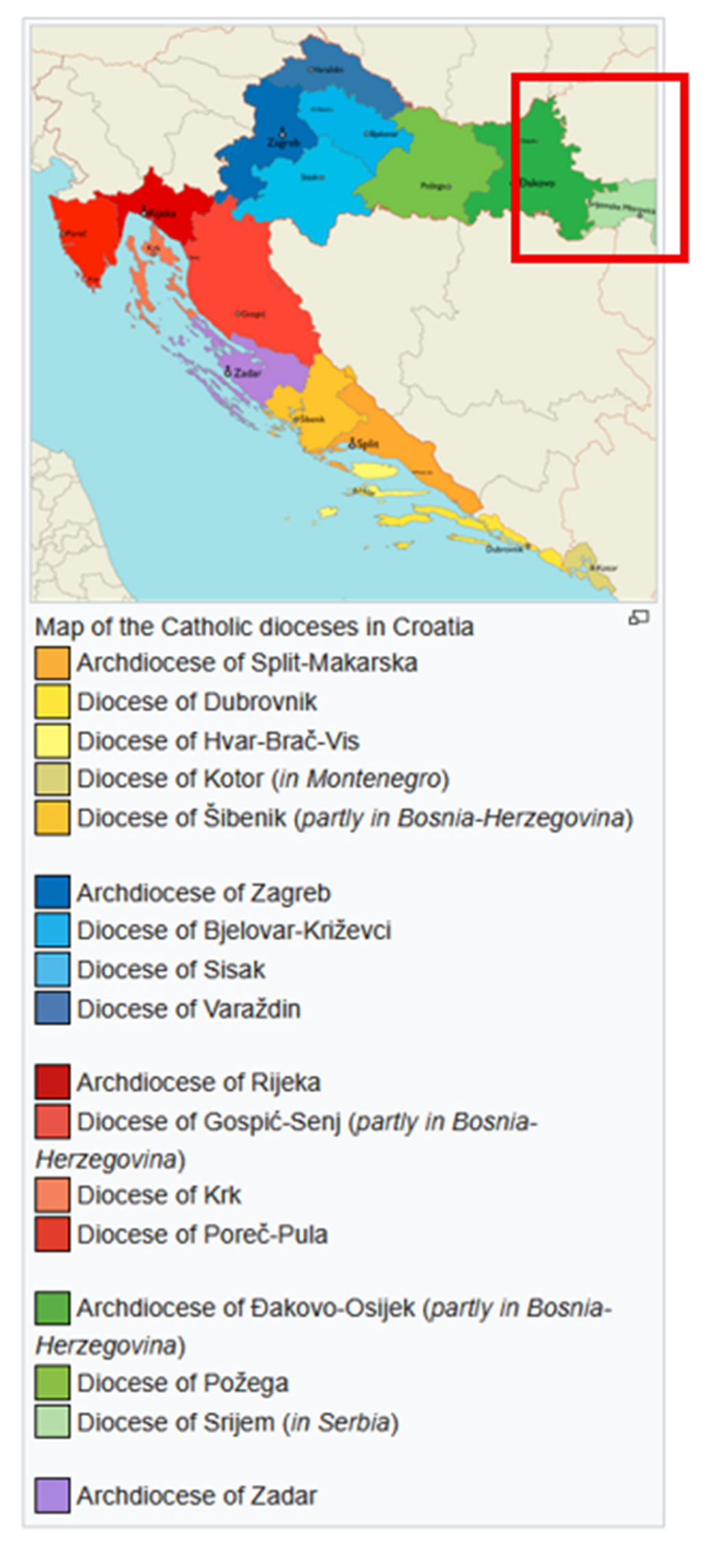
The principal goal of this study was to develop a thematic map of the Archdiocese of Đakovo–Osijek. Two specific objectives were pursued: (1) to investigate the spatial organization of the archdiocese through cartographic analysis, and (2) to present the production process of the thematic map. This paper specifically presents the production and evaluation of a thematic map of the Archdiocese of Đakovo–Osijek as the primary output of that research (Figure 1). The territory of the Archdiocese of Đakovo–Osijek is delineated primarily by natural geographic features—namely, the Sava, Drava, and Danube rivers—excluding portions that fall within the jurisdictions of Vojvodina and Serbia. To the west, the boundary extends from the settlements of Šumeće and Slobodnica, located along the Sava River near Slavonski Brod, reaching up to and including Viljevo, a settlement near the Drava River and the town of Donji Miholjac. The area of Baranja is also encompassed within the archdiocese.
The Archdiocese of Đakovo–Osijek is administratively subdivided into 16 deaneries, comprising a total of 153 parish churches. The seat of the archdiocese is located at the Basilica of Saints Peter and Paul in the town of Đakovo [3].
The resulting map offers not only a detailed geographical overview of the organizational structure of the archdiocese but also contextualizes its historical development, emphasizing the role of rivers as natural borders and the significance of ecclesiastical and urban centers such as Đakovo and Osijek. In this way, the map enriches the broader cartographic representation of Croatia and contributes to a deeper understanding of a region in which religious, cultural, and historical layers are intricately interwoven.
This work is part of a broader project involving the creation of a series of religious thematic maps and studies, the results of which have been published over the past two decades. These works and results have been published in leading international journals, including the Journal of Maps [2], Tehnički Vjesnik [4], and others. As part of an educational research collaboration, 23 geodesy students participated in the digitization, data cleaning, and geospatial processing tasks under supervision. Students who participated were selected based on their work in cartographic course exercises at our faculty. Their main contributions included manual vectorization of historical features, GIS layer structuring, and symbol placement. The main challenges that they encountered were inconsistent toponyms between sources, incomplete attribute data, and managing georeferencing distortions from the historical map. Their efforts were essential for assembling a clean and semantically structured dataset.

State of the Art in Thematic Religious Cartography
Thematic cartography, as a specialized domain within cartographic science, focuses on the representation of specific topics or phenomena—ranging from environmental, demographic, and economic to cultural and religious themes. Within this field, religious cartography remains an underdeveloped subdomain, particularly in Southeast Europe, despite its significant potential for contributing to cultural heritage studies, historical geography, and ecclesiastical planning.
Over the past two decades, scholarly interest in religious spatial analysis has grown in conjunction with developments in Historical GIS (HGIS) and digital humanities, which allow for the integration of archival sources with modern geospatial data. Internationally, research projects such as the Mapping the Reformation (USA), Digitizing Christian Missions Atlas (UK), and Parish Atlas of Italy have demonstrated how religious cartography can be used to analyze the evolution of ecclesiastical territories, patterns of missionary activity, or religious–cultural landscapes.
In the Croatian context, religious cartography has gained scholarly attention primarily through initiatives at the Faculty of Geodesy, University of Zagreb. Since the early 2000s, several diocesan maps—such as those of Požega, Gospić–Senj, and Varaždin—have been developed following a unified cartographic methodology based on official spatial data and ecclesiastical sources. These efforts have positioned Croatia among the few European countries systematically documenting religious territorial organization through thematic maps.
Figure 1. Map of the Catholic dioceses in Croatia (By IoannesII, CC BY–SA 4.0, [5]).
Heritage 08 00356 g001
Despite this progress, a comprehensive theoretical framework for religious cartography is still emerging. Scholars have emphasized the need for consistent symbolization systems, scale harmonization, and integration with historical narratives. As the authors of [6] argue, maps in this context are not neutral representations but spatial narratives embedded with theological, cultural, and political meaning.
This study contributes to that growing body of literature by offering a methodologically transparent and data-driven approach to mapping the Archdiocese of Đakovo–Osijek. It bridges the gap between historical map interpretation and modern cartographic production, using a workflow that can be replicated for other ecclesiastical territories in the region. By doing so, this work not only advances local religious cartography but aligns itself with global trends in the spatial humanities and thematic mapping of religious landscapes.

2. Materials and Methods

Spatially oriented decisions, regardless of their context (cultural, historical, or religious), and regardless of the level at which they are made, can only be undertaken with knowledge of cartographic products, tools, and methods. Understanding geographic space—whether at a national, regional, continental, or global scale—requires appropriate and comprehensible spatial representation. Such representations enable effective analysis and interpretation. These representations draw on diverse sources: the latest orthophoto products, official geodetic data, historical cartographic sources, and ecclesiastical records. They also include older thematic cartographic works, especially historical maps [7] relevant to the study area. Such thematic products are the result of targeted cartographic investigations and are shaped according to established rules of cartographic design, particularly graphic cartographic composition. Furthermore, understanding of geographic space can be enhanced not only by studying contemporary cartographic representations but also by exploring older, historical ones. To make this possible, easier access to old cartographic materials must be ensured, while also preserving them. The digitization of old, analog cartographic representations makes them both accessible and preserved.

2.1. Previous Research

The development of the map of the Archdiocese of Đakovo–Osijek represents a continuation of the long-term project focused on mapping Catholic dioceses in the Republic of Croatia.
At the Faculty of Geodesy, University of Zagreb, the Chair of Cartography initiated a project over twenty years ago dedicated to the study of religious cartographic representations. Along with the researchers from the Chair of Cartography, the project team also included the geodesy students from the same faculty.
The project had initially focused on the mapping of the dioceses of Gospić–Senj, Požega, and Varaždin. These maps were published in an international journal, the Journal of Maps, thereby setting high standards for cartographic representation, including the accuracy of spatial data, the use of official coordinate systems, and the interpretation of religious and historical sources [2]. The map of the Diocese of Šibenik is currently in an advanced stage of preparation, while the map of the Diocese of Poreč and Pula is in its initial development phase. The present work adheres to the same methodological principles, aiming to integrate contemporary spatial data with historical sources into a unified cartographic depiction of one of the most significant ecclesiastical territories in Eastern Croatia.
Globally, thematic cartography has increasingly moved toward interactive, digital, and multidimensional representations, incorporating real-time data, user-generated content, and mobile accessibility. Within this context, religious cartography remains underexplored, despite its potential for representing cultural heritage. The present study contributes to filling this thematic gap and aligns with international efforts such as the Atlas of Christian Missions (USA) or religious space mapping projects in Spain and Poland.
In addition to the aforementioned research and publications, a thorough analysis was conducted on the Map of the Bosnian or Đakovo and Srijem Diocese from 1826 [4,7,8]. In the article analyzing this historical thematic map, it was emphasized that the map was a valuable historical document, encompassing not only ecclesiastical but also secular and natural features. At that time, the diocese extended over parts of the present-day Republic of Croatia and the Republic of Serbia, bounded by the Sava, Drava, and Danube rivers to the south, north, and east, respectively, with the western boundary running approximately from Slavonski Brod to Donji Miholjac. The study identified potential original sources of the map and attributed its creation to Demetrü Görög and Joannis Lipszky [9,10,11,12,13,14,15,16,17]. It provided a historical overview of the establishment of the diocese, a detailed analysis of the religious, secular, and natural contents depicted on the map, translations of all Latin texts, a translation of the map legend, and tabular presentations of the religious demographics in the area [4].
The old map of the Bosnian or Đakovo and Srijem Diocese from the year 1826, kept in the Museum of Slavonia in Osijek, was digitized in September 2016 for the purposes of preparing an article about it [7].
Previous research had provided significant information that served as the basis for the development of the new map of the Archdiocese of Đakovo–Osijek.
The historical Mappa Dioecesium Bosnensis seu Diakovariensis et Syrmiensis (Görög & Lipszky, 1826) [7] was digitized and spatially processed to ensure its preservation. This also enabled integration into GIS workflows and comparison with contemporary data.
The digitization process consisted of several stages:
  • Scanning:
  • The map was scanned in September 2016 using a Contex 600, a large-format rotary scanner. The process was supported by the original digitization software WIDEimage. The output resolution was 500 dpi, with 24-bit color depth, producing an image of 11,703 × 8278 pixels. The image was saved in JPEG format for practical manipulation in CAD and GIS software, with a total file size of 63.9 MB.
  • Initial Processing:
Post-scanning, the image was color-corrected and aligned to minimize distortion caused by the physical condition of the original print. Adobe Photoshop and IrfanView were used for raster cleanup and color balancing.
4.
Georeferencing:
The scanned map was imported into QGIS 3.28 LTR for georeferencing. A first-order polynomial transformation (affine) was selected, using 15 control points corresponding to recognizable features (settlements, rivers, road junctions) visible both on the old map and on modern topographic or orthophoto maps (DOF5). The modern reference map was projected in HTRS96/TM, the official Croatian coordinate system.
5.
Accuracy Assessment:
The Root-Mean-Square Error (RMSE) of the transformation was 12.4 m, which is considered acceptable given the historical nature of the map and its limited metric precision. Control points were evenly distributed to avoid edge distortions.
6.
Vectorization:
Selected ecclesiastical features—parish centers, deanery borders, and notable churches—were vectorized manually using QGIS digitizing tools and assigned attribute data based on historical annotations.
7.
Overlay and Comparison:
The georeferenced historical map (Figure 2) was overlaid with modern GIS layers to examine changes in ecclesiastical geography. This facilitated the detection of preserved religious centers, shifts in parish structure, and boundary changes (Figure 3). Notable sources included the following: [2] for the Diocese of Požega; [9] for ecclesiastical boundaries. In the article about the old map, the colors were used exclusively to show the boundaries of the archdeaconries, and hand-coloring was applied. In the original legend (in Latin) and in the translated one (in English), the names of the individual archdeaconries are given. One should refer to the legend of the new map—everything is visible there.

2.2. Study Area and Historical Context

The Archdiocese of Đakovo–Osijek, situated between three major rivers—the Sava, Drava, and Danube—covers an extensive area of Eastern Croatia. This geographically diverse region holds significant historical importance due to the longstanding presence of the Catholic Church and its profound influence on the spiritual, cultural, and spatial development of the area. Along with its geographical complexity, the archdiocese includes the major towns of Đakovo, Osijek, Vinkovci, and Slavonski Brod. Ecclesiastically, it is divided into 16 deaneries and 153 parishes, reflecting the richness and diversity of religious life in the region [18].
Historically, this area has belonged to various ecclesiastical jurisdictions since the Middle Ages. Of particular importance is the former Bosnian or Đakovo and Srijem Diocese, whose historical continuity has been documented since the 13th century.
The Archdiocese of Đakovo–Osijek was formed through the unification of the old dioceses of Bosnia and Srijem. This unification was decreed by Pope Clement XIV through the papal bull Universi orbis Ecclesiis on 9 July 1773, after which it bore the name “Diocese of Srijem”.
On 18 November 1963, the name was changed to the “Diocese of Đakovo or Bosnia and Srijem,” commonly referred to as the “Diocese of Đakovo and Srijem” or “Đakovo–Srijem Diocese.” In 2008, Pope Benedict XVI reorganized the diocese, elevating it to the status of an archdiocese and ecclesiastical province. This led to the establishment of the present-day Archdiocese of Đakovo–Osijek, which serves as the ecclesiastical province overseeing the suffragan dioceses of Požega and Srijem.
The role of Đakovo as the ecclesiastical center is further emphasized by the architectural significance of St. Peter’s Cathedral. The historical changes in the organization of deaneries and parishes reflect broader patterns of settlement development and demographic dynamics in the region.
Therefore, this thematic map makes an important contribution to understanding the spatial structure of the Catholic Church in this area and its relationship to the wider socio-geographical context.
Improvements included enhanced georeferencing accuracy and easier vectorization of historical features.

2.2.1. Boundaries of the Archdiocese

The current boundaries of the Archdiocese of Đakovo–Osijek reflect both historical processes and contemporary ecclesiastical organization. The northern border follows the Drava River, separating the territory from Hungarian dioceses; the eastern boundary traces the Danube River toward Serbia; and the southern boundary, defined by the Sava River, marks the border with Bosnia and Herzegovina. To the west, the archdiocese borders the Diocese of Požega.
This strategic location along three major rivers has made the study area not only significant in ecclesiastical–administrative terms but also historically important from a geopolitical perspective.
In the first half of the 19th century, the Diocese of Đakovo and Srijem bordered the following dioceses and counties: to the north, across the Drava River, it bordered the Diocese of Pécs and Baranya County; the Danube River formed the northeastern boundary with Bačka County and the Archdiocese of Kalocsa, which extended toward the Diocese of Csanád; to the south, the Sava River served as a natural boundary with the Kingdom of Bosnia; and to the west, it bordered the Diocese of Zagreb. The northern boundary stretched from Valpovo on the Drava River to Dubočac on the Sava River, corresponding to the Brod Military Frontier.
At that time, the regions of Požega and the area around Našice had already been annexed to the Diocese of Zagreb [4,7,10].
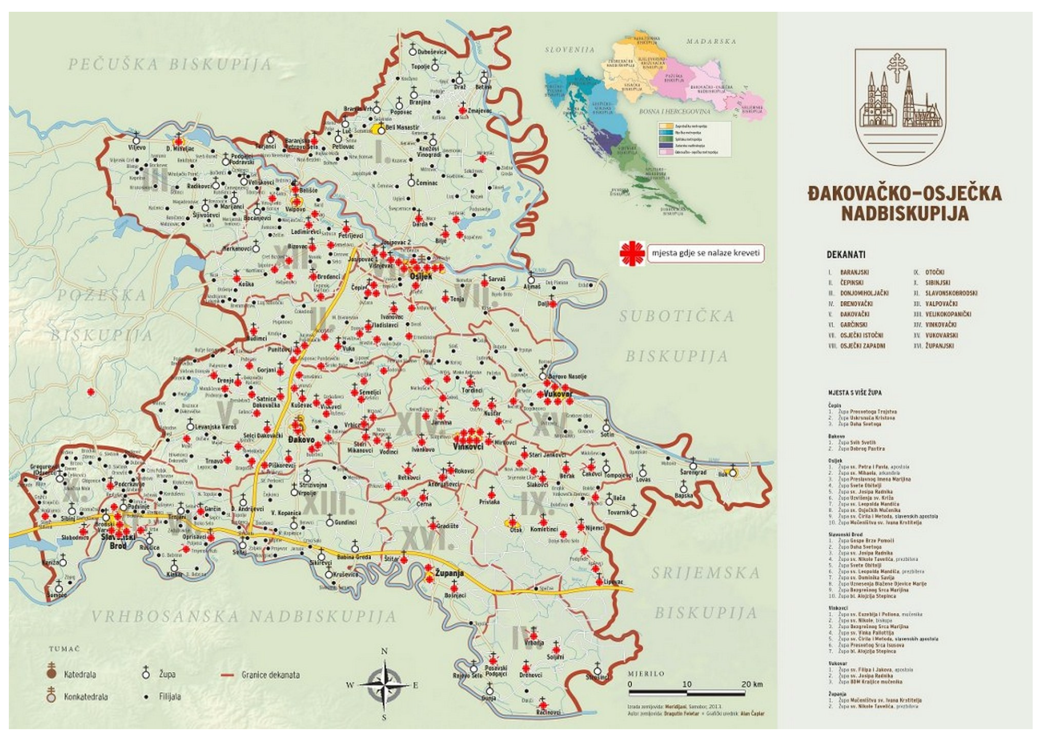
The current boundaries of the Archdiocese of Đakovo–Osijek with neighboring dioceses and archdioceses are shown in Figure 4 and Figure 5.
To the north, in Hungary, it borders the Diocese of Pécs and the Archdiocese of Kalocsa–Kecskemét; to the east, in the Republic of Serbia, it borders the Diocese of Subotica and the Diocese of Srijem; to the south, in the Republic of Bosnia and Herzegovina, it borders the Archdiocese of Vrhbosna; and to the west, within Croatia, it borders the Diocese of Požega.
Over time, including the nearly two centuries that separate the old and the new thematic maps of the diocese/archdiocese—1826 and 2018, respectively—there have been changes in the boundaries of the diocese. Traditional maps are proven tools for communicating such changes in geospatial structures. Both analog and digital cartographic representations can be used for this purpose. In geospatial communication, even topographic maps can serve a valuable role if thematic maps of the targeted content are not available; ideally, however, thematic maps should be used. Maps of various scales, whether detailed or overview, are welcome, as they contribute to different ways of perceiving geographic space. Every creation of a new cartographic representation should be preceded by a purposeful analysis and selection of features, phenomena, and conditions relevant to the specific thematic content being represented on the map (Figure 4). Figure 4 represents the current boundaries of the archdiocese and its neighbors, serving as a base for comparison with historical extents.
Figure 4. Geographical boundaries of the Archdiocese of Đakovo–Osijek and its neighboring dioceses in Croatia, Hungary, Serbia, and Bosnia and Herzegovina [19].
Heritage 08 00356 g004

2.2.2. Ecclesiastical Content on the Map

The text written on the old map of the Bosnian or Đakovo and Srijem Diocese from 1826 [7], titled “Nomina” (Names), is abundant with data regarding the establishment of various monasteries, the relocation of diocesan seats over time, and the formation of individual dioceses. It is evident that at the beginning of the 13th century, the Srijem Diocese was renewed under the Archbishop of Kalocsa, Ugolino; and at the end of the 18th century, the Đakovo and Srijem Diocese was unified. After the Bosnian bishops moved from Bosnia to Slavonia in 1239, Đakovo became the seat of the diocese [4,20,21,22].
At the time of the creation of the map of the Bosnian or Đakovo and Srijem Diocese in 1826, the dioceses were divided into four archdeaconries and nine deaneries. Table 1 shows the existence of 81 parishes [4]. The Cathedral Archdeaconry covered the Đakovo, Osijek, and Kopanica deaneries. The Brod Archdeaconry included only the Brod Deanery. The Upper Srijem Archdeaconry encompassed the Vinkovci and Tovarnik deaneries. The Lower Srijem Archdeaconry included the Mitrovica, Posavina, and Petrovaradin deaneries.
The boundaries between dioceses, archdeaconries, and deaneries are represented by linear cartographic symbols. For better visibility, the deaneries are highlighted by manually coloring additional strips alongside the linear graphic symbols.
The cartographic symbols for larger and smaller towns represent illustrative drawings of church facades [1]. Additionally, the map distinguishes the following objects: parish church, chapel with or without a church, monastery, and convent, as well as the Orthodox, Greek Catholic, Lutheran, Calvinist, and Jewish denominations (Table 2).

2.3. Data Collection in the Process of Creating the New Map

The creation of the thematic map of the Đakovo–Osijek Archdiocese involved the collection and integration of spatial and attribute data from both contemporary and historical sources. Each dataset served a specific function within the cartographic process and was validated for accuracy and thematic relevance. Below is a summary of the main data sources, the types of data extracted, and the corresponding references.
  • Digital Orthophoto Map (DOF5)—State Geodetic Administration (DGU):
    Data Extracted: High-resolution aerial imagery used for visual verification of the position of churches, roads, rivers, and administrative borders.
    • Format: Raster (GeoTIFF).
    • Scale: 1:5000.
    • Reference: State Geodetic Administration [23].
  • Croatian Base Map (HOK):
    • Data Extracted: Base map elements including transportation networks, hydrography, and settlement structure.
    • Format: Vector and raster (official layers in HTRS96/TM).
    • Reference: State Geodetic Administration [23].
  • Digital Cadastral Plan (DKP) and Register of Spatial Units (RPJ):
    • Data Extracted: Precise cadastral boundaries, names of settlements, and spatial hierarchy.
    • Access Method: WFS (Web Feature Service).
    • Reference: State Geodetic Administration [23].
  • Register of Geographical Names (RGI)—DGU:
    • Data Extracted: Toponyms of settlements, parishes, protected areas, and geographic entities.
    • Format: Point vector layer (shapefile).
    • Reference: State Geodetic Administration [24].
  • OpenStreetMap (OSM):
    • Data Extracted: Vector layers for roads, rivers, and settlement layouts.
    • Usage: Supplemental data where official sources were lacking; filtered for thematic simplification.
    • Reference: OpenStreetMap contributors [25].
  • DIVA-GIS—Administrative Boundaries:
    • Data Extracted: National- and diocesan-level boundaries for Croatia; used for defining deanery divisions.
    • Format: Shapefile.
    • Reference: DIVA-GIS [26].
  • Official Website of the Đakovo–Osijek Archdiocese:
    • Data Extracted: Locations and names of parish churches, deanery centers, cathedrals/co-cathedrals, and sanctuaries.
    • Usage: Thematic core layer (point features).
    • Validation: Cross-referenced with Google Maps and direct inquiries to pastoral offices.
    • Reference: Đakovo–Osijek Archdiocese [20,21].
  • Historical Map of the Diocese of Bosna or Đakovo and Srijem (Görög & Lipszky, 1826):
    • Data Extracted: Historical ecclesiastical structure including archdeaconries, deaneries, and parishes; cartographic symbology.
    • Usage: Comparative analysis and georeferenced historical layer.
    • Reference: [7]; analyzed in [4].
  • Google Maps and Address-Based Coordinate Extraction:
    • Data Extracted: Geolocation of churches and church institutions using postal addresses and satellite view.
    • Usage: Positional accuracy of point features.
    • Reference: Manual extraction using Google Maps API.
All collected data were standardized in HTRS96/TM projection and processed within the QGIS 3.28 environment. Thematic filtering, generalization, and data cleaning were performed to ensure the legibility and topological consistency of the final map.

Data Collection

The data collection process for creating the thematic map of the Đakovo–Osijek Archdiocese was multi-phased and involved the use of both contemporary digital and historical sources. The official, institutionally verified sources of spatially referenced data were used [27,28,29], as well as church documents and cartographic materials from the historical archives. The goal was to ensure a comprehensive and reliable database for cartographic processing.
The accuracy of the source material greatly affects the accuracy of map production. In geodesy, as well as in the creation of various thematic maps, source materials form the foundation for building databases. In the process of creating the thematic map of the Archdiocese of Đakovo–Osijek, the data were obtained using the following sources: the Digital Orthophoto Map at a scale of 1:5000 (DOF5), data collected via OpenStreetMap [25], administrative boundaries downloaded from the DIVA-GIS website [26], a vector layer containing data from the Register of Geographical Names of the State Geodetic Administration (DGU), and data on church structures gathered from the official website of the archdiocese. The sources used were available at a larger or approximately equivalent scale to the map being developed.
The main contemporary sources were the Digital Cadastral Plan (DKP) and the Register of Spatial Units (RPJ), obtained from the State Geodetic Administration (DGU) of the Republic of Croatia. These data allowed for the precise definition of the settlement boundaries, cadastral municipalities, and transportation infrastructure, as well as the identification of fundamental spatial layers that served as a foundation for further enhancement. Data access was ensured through WFS (Web Feature Service) and integrated into the GIS environment [23].
In Croatia, one of the official national maps is the Croatian Base Map (HOK), which is produced at a scale of 1:5000. It is created for the entire territory of the Republic of Croatia. Previously, it was known as the Basic State Map (ODK), and its production began in the mid-1950s (1954). The map’s production continued until 2009, when the final sheets of the HOK were officially released for use. The entire territory of the Republic of Croatia is covered by 9802 HOK sheets. Each sheet covers an area of 675 hectares according to the old Gauss–Krüger division. The main source for creating the HOK was large-scale aerial photogrammetric surveying, and the data on the map are presented with a minimal level of generalization. The HOK was produced in the 5th and 6th zones of the Gauss–Krüger cartographic projection on the Bessel 1841 ellipsoid, and all sheets were transformed into the HTRS96/TM system using a 7-parameter transformation. Since 2011, HOK sheets have been produced in a new sheet layout and using the new HTRS96/TM cartographic projection on the GRS80 ellipsoid.
Additionally, the publicly available digital orthophoto images (DOF) were used, enabling visual verification of the field conditions and more accurate geolocation of specific objects.
The Digital Orthophoto Map (DOF5) is also an official state map, produced at a scale of 1:5000 for the entire territory of the Republic of Croatia. The production of DOF5 is based on aerial photogrammetric imagery, captured in accordance with the appropriate technical product specifications. Since 2011, DOF5 has been produced in the new HTRS96/TM cartographic projection, based on the GRS80 ellipsoid. In the creation of the thematic map of the Archdiocese of Đakovo–Osijek, along with the HOK, DOF5 was used to verify both the national border and the boundaries of the archdiocese.
OSM vector data were used as a supplementary source for road and river networks, especially where official datasets were incomplete. OSM collects, organizes, and stores geospatial data that are free and publicly available. These data are distributed under the Open Database License. Based on these geospatial datasets, both free and commercial maps can be produced. When using these data, the source must be credited. OSM is built by various users who, with the help of GPS or their own local knowledge, contribute to updating and expanding map content. OSM data are downloaded in vector format from the relevant websites [30,31].
The State Geodetic Administration (DGU) has issued the Register of Geographical Names [24]. This register contains toponyms organized alphabetically or by another order and includes information on the location of the toponym, the type of object, and other attributes. It includes names of counties, cities/municipalities, settlements, UNESCO World Heritage sites in the Republic of Croatia, airports, national parks, nature parks, and other protected natural sites. These data are downloaded directly from the DGU website via WFS (Web Feature Service) as a point vector layer. The layer can be saved in shapefile format and edited as needed.
For details related to the church structure, official parish, deanery, and other church institutions, the lists from the Đakovo–Osijek Archdiocese’s websites were used, with data further confirmed through communication with pastoral offices.
For this thematic map, DIVA-GIS was used to download administrative boundaries in the Republic of Croatia, based on which the boundaries of deaneries in the archdiocese were determined. DIVA-GIS is a free computer program used for mapping and analysis of geographic data [26]. It can be used to create maps of the entire world, a specific region, or very small areas. In addition to map creation, DIVA-GIS allows the download of free spatial data for the selected area.
From the historical point of view, the research included the analysis of the 1826 map of the Bosnian or Đakovo and Srijem Diocese, created by Görög and Lipszky. Since this map contains crucial data on the church’s spatial organization in the 19th century, it served as an invaluable reference for comparing the spatial structure over time. Information from the map was supplemented by data from [4] and other historiographical sources.
Secondary sources such as the cartographic representations of other Croatian dioceses, created as part of the religious cartography project, were also used, enabling comparison and methodological consistency [9]. The collected data were then structured and organized into separate layers within GIS software, and they were classified according to thematic affiliation (religious, hydrographic, transportation, administrative).
The main historical source was the Mappa Dioecesium Bosnensis seu Diakovariensis et Syrmiensis (1826) by Görög and Lipszky [7], extensively analyzed in [4]. Ecclesiastical boundaries and structures were cross-verified with online sources [18,20], as well as historiographical documents [21,22].
Once all of the data were collected, validation was conducted, including comparisons with the available maps, verification in the orthophoto representation, and manual checks in cases where data were contradictory or incomplete. This ensured the accuracy of the foundational database for the creation of the final map [32].
The layer explanation can be found in Table 3:

2.4. Creating a New Map

The creation of the map of the Đakovo–Osijek Archdiocese was based on the application of modern GIS tools, cartographic principles, and methodological standardization to ensure an accurate, legible, and contextually relevant representation. The entire methodological process was divided into several key steps: spatial data processing, definition of thematic elements, generalization, design, and creation of the final map.

2.4.1. The Coordinate System and Scale

The official Croatian coordinate system HTRS96/TM (Transverse Mercator projection) was used [33]. The Government of the Republic of Croatia decided to introduce a new official coordinate system for the Republic of Croatia as of 4 August 2004, for the epoch 1995.55—abbreviated as HTRS96 (Croatian Terrestrial Reference System). In addition, a new projected coordinate system of the Transverse Mercator (Gauss–Krüger) projection was adopted—abbreviated as HTRS96/TM [34]. The central meridian is 16°30′ E, and the projection scale is 0.9999.
The paper format was defined as A1. The base map was displayed at a scale of 1:250,000, while for detailed representations of the towns of Osijek and Slavonski Brod, the scales were 1:70,000 and 1:80,000, respectively.

2.4.2. Data Processing

The thematic content (religious objects) was filtered according to significance. Significance was determined based on ecclesiastical hierarchy (e.g., inclusion of cathedrals, deanery centers, and pilgrimage sites), historical continuity, and spatial relevance at the map scale. Generalization was applied to simplify transportation and hydrological elements, thereby emphasizing the thematic content of the map. Based on the sources, objects to be included in the cartographic representation were defined, and digital processing of spatial data was performed. To highlight the religious features and reduce the map density, only major roadways were included: highways, state roads, and county roads. Rivers were simplified using the same procedure. For the linear and polygonal objects, line generalization was performed, and edges were adjusted in accordance with the scale.

2.4.3. Cartographic Design

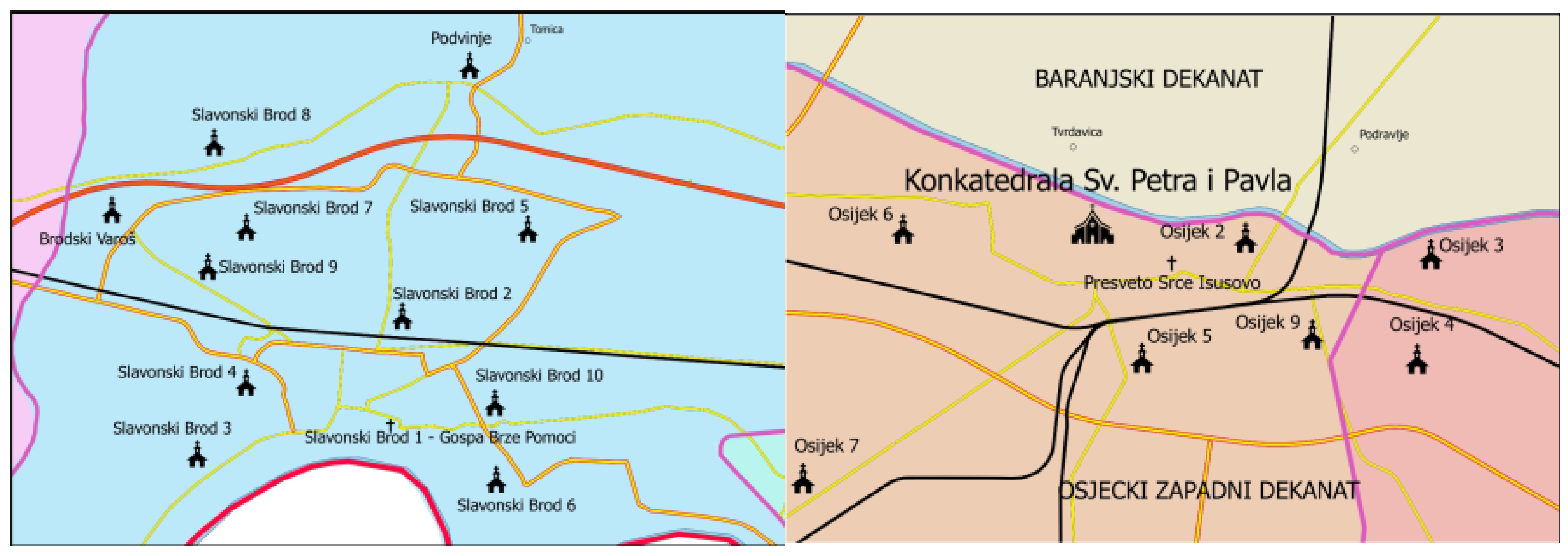
After filtering the necessary data and applying generalization, the map was edited. Since the areas of the towns of Slavonski Brod and Osijek contained numerous objects, two separate cartographic representations were created for these towns, at scales of 1:70,000 for Osijek and 1:80,000 for Slavonski Brod. Thus, the final cartographic representation included thematic objects such as the boundaries of the diocese and deaneries, the cathedral/co-cathedral, deaneries and their headquarters, sanctuaries, and parish churches [35], while the general geographic elements included settlement names, roadways (railways, highways, state roads, and other roads), and rivers.
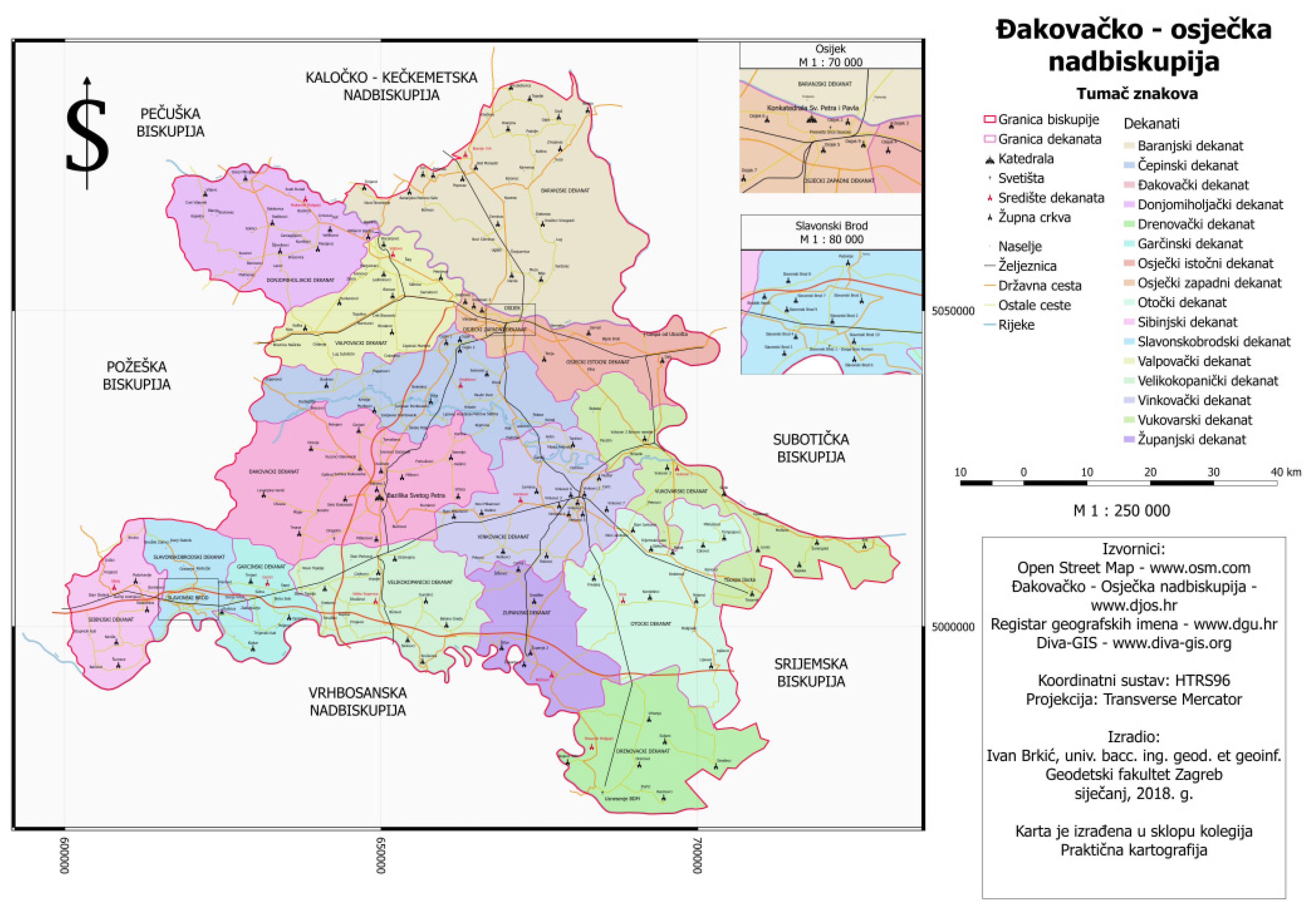
Cartographic symbols were created according to thematic cartography standards. A legend, scale, coordinate grid, and source data were added to the map. The boundaries between the deaneries and neighboring dioceses were clearly shown to highlight the ecclesiastical organization of space. The final appearance of the map is displayed in Figure 5.
Figure 5. The first version of the map created by the students of the Đakovo–Osijek Archdiocese [36].
Heritage 08 00356 g005
This cartographic representation could be further enhanced by adding thematic objects such as monasteries, chapels, cemeteries, and police and military chaplaincies. At the time of creating this student version of the map, the required sources were not available on the Internet [36].
From a historical perspective, cartography is among the oldest communication and information graphics developed according to certain methodological rules. Today, science and technology contribute to the creation of new products on the market, which are often of lower quality for economic reasons. Cartographic science should guide consumers deliberately towards selecting high-quality products. Without this guidance—due to market conditions—there will be a decline in the quality of cartographic products.
The presence of a lack of cartographic awareness about quality among users inevitably leads to a crisis in the survival of cartographic science itself. Without knowledge of quality cartographic products, and without understanding all of the possibilities of cartography, combined with the existence of often inadequate cartographic representations on the market, the very institutional existence of cartography is questioned and endangered.
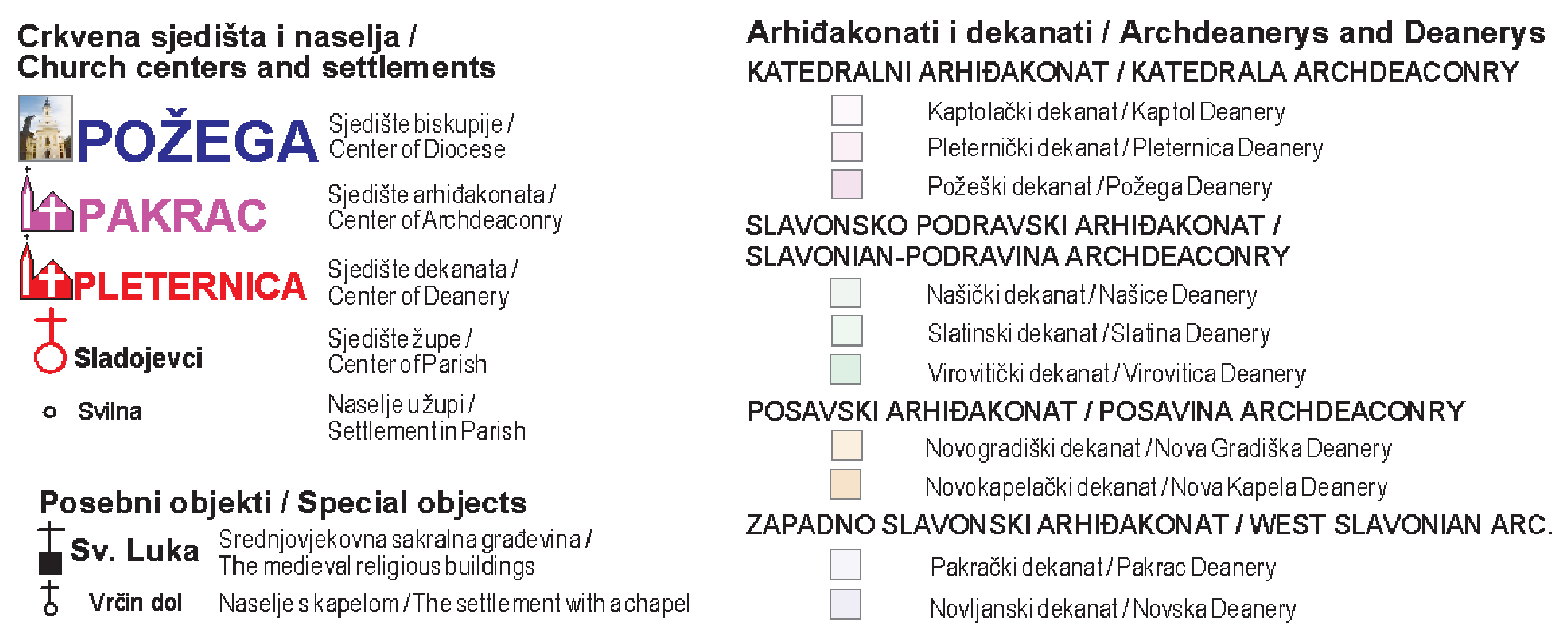
For comparison, Figure 6 shows the cartographic symbols of the special thematic content used in the map of the Požega Diocese [2]. Figure 6 illustrates the symbol system developed for the map of the Požega Diocese, which served as a reference model for symbol consistency and visual hierarchy in the Đakovo–Osijek map. The map’s authors always kept in mind the necessary positional and semantic accuracy according to the map scale.
The symbol design followed ISO 19,117 standards and conventions from prior diocesan maps [2]. Religious symbols were differentiated not only by geometry (e.g., cross, circle, spire) but also by color-coding to aid colorblind users: cathedrals in dark blue, parish churches in dark red, and pilgrimage sites in green.

2.4.4. Creating the Final Map

Figure 5 shows the initial student-produced version of the map, which formed the basis for the final, optimized version. The first step was importing the spatial data into the GIS environment, using the previously described computer program DIVA-GIS, along with other software tools such as ArcGIS and QGIS [37]. After that, the integration of layers with spatial data on the boundaries of deaneries, parish churches, transportation networks, watercourses, and settlements was carried out. Each mapped object was assigned attributes that allowed for classification and visual interpretation according to the theme.
Since the task involved creating a thematic map of the Đakovo–Osijek Archdiocese, the focus was on the sacred buildings themselves, while only the basic general geographic elements were included: boundaries, roads, and rivers. The necessary layers were collected from the sources mentioned above. Vector layers for roads and rivers were downloaded from OSM, the WFS layer of geographic names from DGU, and administrative boundaries for the Republic of Croatia from DIVA-GIS. Data on the names and locations of the cathedral, co-cathedral, deanery seats, and parish churches were found on the official website of the archdiocese, and their coordinates were determined using the addresses of these objects and the Google Maps application. In QGIS (Quantum GIS), the geometric command “Intersection” was used to filter only the data located within the area of the archdiocese.
In the next step, data generalization was applied, particularly to linear and point elements. This reduced the information density and ensured readability at the map’s scale of 1:250,000. The religious content was prioritized, while the transportation routes and the hydrographic network were included only in the most important segments. For areas with a higher density of objects, such as the towns of Osijek and Slavonski Brod, the separate enlarged maps at larger scales were created.
A special emphasis was placed on the design and standardization of the cartographic symbols [38]. A legend was developed to visually distinguish the parish churches, cathedrals, sanctuaries, and other significant places. The legend was placed on the map alongside the scale, north arrow, coordinate grid, and list of sources. Color, contrast, and shape were used to emphasize the thematic structure of the map and facilitate its readability.
The final phase involved design refinement and readability testing. An internal review was conducted within the Department of Cartography at the Faculty of Geodesy. The map was further optimized for print publication and digital distribution. The methodological approach used in this study was based on thematic cartography standards and was tailored to represent the ecclesiastical territorial organization.
The generalization process was governed by scale-dependent thresholds: only settlements with over 500 inhabitants were labeled, rivers with a Strahler stream order ≥3 were retained, and only primary and secondary road classes were included. Cartographic line simplification was implemented using the Douglas–Peucker algorithm with a 50 m tolerance to maintain visual clarity at a 1:250,000 scale.
A snapshot of the attribute table showing structured information for parish churches in the archdiocese can be found in Figure 7.

2.4.5. Integration of Historical and Contemporary Data

A critical component of the map design was the integration of data derived from the historical 1826 map of the Đakovo and Srijem Diocese. After digitization and georeferencing, the historical features—such as deanery boundaries, major religious centers, and parish placements—were overlaid with contemporary GIS layers. This overlay enabled the comparison of spatial continuity and informed decisions on which historical features were preserved in the current ecclesiastical organization.
For example, preserved deanery centers from the 1826 map were confirmed as still active in the contemporary data and emphasized accordingly in the symbology. Where boundaries or parishes had shifted, annotations were made to reflect historical continuity or change. This process allowed for a diachronic reading of ecclesiastical spatial organization and added depth to the thematic structure of the final map.

2.4.6. Cartographic Design Process and Symbolization Inserted

The cartographic design was based on established thematic mapping principles, following symbol conventions used in previous diocesan maps [2]. Religious objects were classified into four categories—cathedrals, co-cathedrals, deanery centers, and parish churches—each assigned a unique symbol and color to ensure visual differentiation. A colorblind-safe palette was used [39].
Linear generalization (Douglas–Peucker algorithm) and feature selection thresholds were applied to rivers and roads to reduce map clutter. Labels were placed using QGIS’s automatic placement rules and manually adjusted for readability. Generalization rules ensured that only features of regional ecclesiastical relevance were retained, with others omitted for clarity at a 1:250,000 scale.

2.4.7. Readability Testing and Review Workflow

Internal review and readability testing were conducted at the Faculty of Geodesy’s Department of Cartography. Faculty members, students, and clergy reviewed the initial map version, focusing on label readability, symbol clarity, and overall visual balance. Feedback included increasing the symbol size for parish churches, adjusting the legend contrast, and improving the river name placement. These suggestions were incorporated into the final version. Figure 5 represents the first internal version; the final optimized version is included in the Supplementary Materials.

2.5. Historical GIS and Spatial Humanities Context

The present study aligns with the growing interdisciplinary field of spatial humanities, which integrates geospatial technologies with humanistic inquiry, particularly in the domains of history, religious studies, and cultural heritage. A key methodological framework within this field is Historical GIS (HGIS)—the use of Geographic Information Systems to analyze and visualize historical data, maps, and narratives in a spatialized manner.
HGIS enables scholars to georeference historical maps, integrate archival records, and reconstruct past geographies for comparative analysis with present-day spatial configurations. The digitization of historical cartographic materials, such as the 1826 map of the Bosnian or Đakovo and Srijem Diocese, represents a typical entry point into HGIS workflows, where analog sources are transformed into digital geospatial data.
Numerous studies in the field demonstrate diverse approaches to historical map digitization:
  • Ref. [40] emphasizes methodologies for temporal and spatial precision in HGIS projects, including the challenge of aligning historical boundaries with modern coordinate systems;
  • Ref. [41] explores case studies in Historical GIS and emphasizes the importance of integrating textual sources with spatial layers;
  • Ref. [6] stresses the interpretive dimension of Historical GIS, noting that spatial representations are not merely technical products but narratives embedded with meaning;
  • Ref. [42] discusses the reconstruction of religious and administrative geographies in Europe using parish-level historical data and spatial interpolation.
In the Croatian context, significant contributions to historical geography and map-based spatial analysis have been provided by [43], particularly in the study of insular geographies and diachronic spatial structures. In practice, the digitization of historical maps such as Görög and Lipszky’s 1826 map requires methodological attention to the following:
  • Coordinate Transformation: Aligning historical non-metric maps to modern reference systems;
  • Uncertainty Assessment: Documenting historical inaccuracy and positional imprecision;
  • Metadata Enrichment: Linking digitized map elements with archival records and ecclesiastical registries.
The present research contributes to this growing body of literature by demonstrating how a nineteenth-century ecclesiastical map can be integrated into a GIS environment, compared with contemporary spatial structures, and visualized using modern cartographic standards. It illustrates the importance of religious spatial structures in historical geography and underscores the value of old maps not only as visual artifacts but as datasets capable of supporting quantitative and qualitative spatial analysis.

3. Results

The final thematic map of the Archdiocese of Đakovo–Osijek (Figure 5) presents a coherent and visually accessible representation of the contemporary ecclesiastical organization while embedding it in a historical perspective. The map shows the boundaries of the archdiocese and its deaneries, the location of the cathedral in Đakovo, and the distribution of parish churches, sanctuaries, and other significant religious sites. Geographic context is provided through the inclusion of major rivers, key transportation routes, and settlements, ensuring that the ecclesiastical features are easily interpreted within their broader spatial setting. Enlarged insets for Osijek and Slavonski Brod highlight the areas with a dense concentration of religious sites, allowing for clarity without compromising scale.
When compared with the georeferenced 1826 “Mappa Dioecesium Bosnensis seu Diakovariensis et Syrmiensis,” the map reveals a mixture of continuity and transformation. Longstanding centers such as Đakovo, Osijek, and Vinkovci have maintained their prominence, while the internal organization of deaneries has been adapted to reflect modern pastoral and administrative needs. Boundaries have shifted to align with current national borders, and the parish network has grown from 81 in 1826 to 153 today, reflecting demographic changes, urban expansion, and evolving patterns of settlement. Some rural parishes depicted in 1826 no longer exist in their original form, having been consolidated or relocated, while new parishes have been established in growing urban areas.
The integration of historical and contemporary datasets has resulted in a map that is both accurate and thematically focused. By applying standardized symbols, scale-dependent generalization, and authoritative spatial boundaries, the cartographic design emphasizes the ecclesiastical content while maintaining geographic clarity. This approach not only enables a direct visual comparison between past and present but also produces a mapping framework that can be replicated for other dioceses. Compared with earlier diocesan maps, the present work offers refined visual hierarchy, enhanced accessibility through colorblind-safe palettes, and verified positional accuracy, thereby increasing both its scholarly and practical value.
The final optimized map, available in high resolution in the Supplementary Materials, serves as a comprehensive spatial record of the Archdiocese of Đakovo–Osijek. It provides an up-to-date reference for ecclesiastical planning while also functioning as a historical narrative that connects more than two centuries of religious cartography in the region.

3.1. Data Collection and Processing Workflow

The process of data collection and preparation for the thematic map of the Đakovo–Osijek Archdiocese followed a structured workflow composed of five main phases. Each phase involved specific methods, tools, and sources, as detailed below:
  • Phase 1: Definition of Cartographic Scope and Thematic Focus
  • Objective: Define the geographic extent and religious content to be represented (archdiocesan boundaries, deaneries, parishes, significant churches).
  • Method: Literature review; consultation with ecclesiastical sources.
  • Sources: Archdiocese website [20], Catholic Church administrative structure [3], and historical texts [21,22].
  • Phase 2: Collection of Contemporary Spatial Data
  • Objective: Acquire geospatial layers for base map construction.
  • Method: Download of official geodata and crowdsourced content.
  • Sources:
    DOF5 and HOK—Aerial imagery and base map elements (State Geodetic Administration) [23].
    DKP and RPJ—Cadastral boundaries and settlement hierarchy [23].
    RGI—Toponyms and geographic features [24]; OpenStreetMap—Roads, rivers, settlements [25].
    DIVA-GIS—Administrative boundary layers [26].
  • Phase 3: Historical Map Processing and Georeferencing
  • Objective: Digitize and georeference the 1826 historical map for temporal comparison.
  • Methods:
  • High-resolution scanning (500 dpi, 24-bit).
  • Georeferencing in QGIS using first-order affine transformation (RMSE = 12.4 m).
  • Vectorization of archdeaconries, deaneries, and ecclesiastical symbols.
  • Sources:
    Görög & Lipszky (1826) historical map [7];
    Analysis by [4].
  • Phase 4: Extraction and Validation of Ecclesiastical Content
  • Objective: Identify and locate current churches, sanctuaries, and deanery centers.
  • Methods:
    Manual extraction of coordinates using Google Maps;
    Data verification via orthophoto overlays (DOF5);
    Consultation with pastoral offices.
  • Sources:
    Archdiocese official website [20];
    Google Maps API/manual search;
    DOF5 imagery [23].
  • Phase 5: Integration, Generalization, and Symbolization
  • Objective: Create a readable, thematically accurate map product.
  • Methods:
    Integration of all layers in QGIS 3.28;
    Filtering of thematic content (e.g., major roads only);
    Generalization of linear and point features to match map scale (1:250,000);
    Design of thematic symbols and legend elements.
  • Outcome: Finalized map suitable for both digital and print distribution.
This workflow ensured that both historical and contemporary elements were methodologically harmonized and cartographically accurate. It provides a reproducible model for similar ecclesiastical and cultural heritage mapping projects.

3.1.1. Objectives and Rationale

The primary objective of this research was to develop a cartographically accurate and thematically rich representation of the Archdiocese of Đakovo–Osijek. Beyond producing a map, this study sought to explore how historical and contemporary ecclesiastical spatial data can be integrated using geoinformation tools. Specific research questions guiding the project included the following:
How have the ecclesiastical boundaries and parish networks of the Đakovo–Osijek Archdiocese evolved over time?
In what ways can historical analog maps be transformed into usable geospatial data for comparative cartographic analysis?
What are the minimum requirements for symbolization and generalization in religious thematic maps to ensure legibility and interpretability?

3.1.2. Methodological Framework

This research followed an interdisciplinary approach rooted in thematic cartography and Historical GIS (HGIS), supported by digital humanities practices. Methodologically, the study combined the following:
Cartographic design theory for symbol selection, hierarchy, and generalization;
GIS-based spatial analysis for overlaying and comparing historical and contemporary datasets;
Comparative cartography to assess the continuity or changes in the spatial configuration of religious institutions.
This integrative framework enabled a diachronic interpretation of spatial religious organization over a 200-year period.

3.1.3. Data Source Justification

Data selection was guided by availability, official status, thematic relevance, and spatial precision. Contemporary spatial datasets were obtained from verified public repositories (e.g., the State Geodetic Administration, DIVA-GIS, and OpenStreetMap), while ecclesiastical data were extracted from the official website of the Đakovo–Osijek Archdiocese.
Historical data were derived from the Mappa Dioecesium Bosnensis seu Diakovariensis et Syrmiensis (1826), a crucial primary source held by the Museum of Slavonia in Osijek. This historical map was prioritized due to its fine level of detail, ecclesiastical specificity, and spatial coverage aligning with the contemporary archdiocese.

3.1.4. Digitization Process

The 1826 map was scanned at 500 dpi and subjected to color correction and distortion minimization. This raster image was then georeferenced in QGIS using a first-order affine transformation, with 15 manually selected ground control points matched to DOF5 orthophotos. The resulting RMSE of 12.4 m was deemed acceptable given the historical nature of the source.
Manual vectorization was performed for deanery boundaries, parish sites, and cartographic symbols, which were then cross-referenced with contemporary datasets and ecclesiastical records.

3.1.5. GIS Integration and Layer Logic

Thematic data were structured into separate vector layers, including the following:
Boundaries (archdiocesan and deanery);
Religious objects (cathedral, co-cathedral, parish churches, sanctuaries).

3.1.6. General Geographic Elements (Rivers, Roads, Settlements)

Layer symbology and hierarchy were defined according to cartographic conventions and the importance of thematic clarity. A base scale of 1:250,000 was adopted to balance information density with regional readability. Areas of high object density, such as Osijek and Slavonski Brod, were extracted and mapped at larger scales (1:70,000 and 1:80,000, respectively).

3.1.7. Visual Validation and Internal Peer Review

After layer integration and symbolization, the draft map was reviewed by cartography faculty and GIS specialists. Validation included positional checks via orthophoto overlays and semantic checks through consultations with pastoral offices. Additionally, the internal review ensured compliance with cartographic best practices and thematic consistency with earlier diocesan maps (e.g., Požega, Gospić–Senj).
This structured methodology ensures that the resulting thematic map is not merely a visual product but a scientifically grounded, reproducible, and comparative spatial representation.

3.2. Comparative Reflection with Similar Case Studies

The methodological approach applied in this study aligns with international practices in historical and religious GIS mapping. Comparable projects include the digitization and geospatial reconstruction of parish networks in 19th-century England [40], ecclesiastical mapping in the Austro-Hungarian Empire [44], and church geographies of Italy and Spain during the Counter-Reformation [45].
In Croatia, similar studies have focused on the dioceses of Gospić–Senj, Varaždin, and Požega, using consistent GIS-based methods and official spatial layers. This study builds upon those efforts by incorporating both historical and contemporary ecclesiastical structures and combining them within a unified cartographic representation.
The strength of this project lies in its integrative methodology that includes georeferenced historical cartography, official spatial data, ecclesiastical records, and public geospatial databases (e.g., OpenStreetMap), making it applicable for both academic research and ecclesiastical planning.

4. Discussion

The presented map provides a valuable overview of the church-geographical organization of the Đakovo–Osijek Archdiocese. The combination of the historical and contemporary data with the GIS methodology ensures the quality of the depiction. Potential improvements include the addition of data on monasteries, chapels, and military chaplaincies, for which further sources need to be gathered.
A comparison with the map from 1826 demonstrates the continuity of spatial organization and the significance of the town of Đakovo as a religious center. The map can serve in ecclesiastical planning, and as a tool in historical, cultural, and theological research.
Thematic geospatial representations facilitate decision-making. Textual descriptions of a specific area, without an accompanying adequate cartographic product, hardly reach the users. The phrase “A picture is worth a thousand words” precisely supports the argument for the need to create (thematic) cartographic representations, either as independent means of communication or as supplementary tools alongside accompanying textual documents.
Although the cartographic form adheres to standard thematic map conventions, the innovation lies in the integration of a 19th-century analog ecclesiastical map into a contemporary GIS-based spatial narrative, enabling diachronic spatial analysis that was not previously available.

5. Conclusions

The map of the Đakovo–Osijek Archdiocese is a significant contribution to the cartographic documentation of religious territories in Croatia. It complements the previously created diocesan maps and supports interdisciplinary research in the humanities and social sciences.
Today’s trends in networking and globalization, together with interdisciplinarity and transdisciplinarity, enable the integration of related and fundamental sciences, erasing the previously clear boundaries of competencies between individual scientific fields. Cartographic science, with its numerous products, contributes to mutual substantive and methodological interactions among different branches of science. Spatial planning overlaps with hydrogeology and geology, which, in turn, connect to biology and meteorology. Forestry and agricultural sciences are in direct contact with the aforementioned fields. Economic science, social science, demography, geography, religion, and many other humanities also build upon this chain of users and “dependents” on cartographic products. The contribution of cartographic representations in all segments of human activity is significant and easily recognizable. This research provides a methodological framework that can be applied in further studies of religious cartography in other regions.

Supplementary Materials

The following supporting information and map of Đakovačko-osječke nadbiskupije can be downloaded at https://hrcak.srce.hr/file/322646 (accessed on 20 June 2025), and at https://mega.nz/file/xUYAAR7Z#-riAUGdIeTQl6wFtphdx3_wZve4_P2mWT3l358Z-ISk (accessed on 20 June 2025).

Author Contributions

Conceptualization, S.F., B.M. and R.Ž.; methodology, S.F. and R.Ž.; software, R.Ž.; validation, S.F. and R.Ž.; formal analysis, S.F. and R.Ž.; investigation, S.F., B.M. and R.Ž.; resources, S.F.; data curation, B.M. and R.Ž.; writing—original draft preparation, S.F. and R.Ž.; writing—review and editing, B.M. and R.Ž.; visualization, S.F. and R.Ž.; supervision, R.Ž.; project administration, R.Ž.; funding acquisition, S.F. and B.M. All authors have read and agreed to the published version of the manuscript.

Funding

This research received no external funding.

Data Availability Statement

The datasets presented in this article are readily available because the data are part of an ongoing study. The datasets generated and used in this study—including shapefiles and geopackages representing the boundaries of the archdiocese, deaneries, and ecclesiastical sites—will be made openly available via the Zenodo repository (DOI to be assigned upon acceptance). All spatial data are provided in the HTRS96/TM coordinate system and are linked at https://mega.nz/folder/xEoS2KoY#2IebCalow_cBAZwaKhOxDQ.

Acknowledgments

To the church authorities for their contribution in reviewing and providing suggestions, and to the Museum of Slavonia in Osijek for granting us permission to publish the cartographic symbols used on the old map of the Đakovo or Bosnian and Srijem Diocese, from the year 1826.

Conflicts of Interest

The authors declare no conflicts of interest.

References

  1. Lovrić, P. Opća Kartografija; Sveučilišna naklada Liber: Zagreb, Croatia, 1988. [Google Scholar]
  2. Župan, R.; Frangeš, S. Map of the Diocese of Požega (Dioecesis Posegana). J. Maps 2015, 11, 496–505. [Google Scholar] [CrossRef]
  3. Biskupije—Hrvatska Biskupska Konferencija. Available online: https://hbk.hr/home-2-2/nad-biskupije/ (accessed on 8 May 2025).
  4. Malić, B.; Frangeš, S. The Map of the Bosnia or Đakovo and Syrmia Diocese. Teh. Vjesn. 2019, 26, 801–806. [Google Scholar] [CrossRef]
  5. File: Map of Roman Catholic Dioceses in Croatia.svg—Wikimedia Commons. Available online: https://commons.wikimedia.org/w/index.php?curid=150828545) (accessed on 15 August 2025).
  6. Bodenhamer, D.J.; Corrigan, J.; Harris, T.M. (Eds.) Deep Maps and Spatial Narratives; Indiana University Press: Bloomington, IN, USA, 2015. [Google Scholar]
  7. Görög, D.; Lipszky, J. Mappa Dioecesium Bosnensis seu Diakovariensis et Syrmiensis; Pest, Hungarian; Museum of Slavonia: Osijek, Croatia, 1826; (inventory number P-1404). [Google Scholar]
  8. Peterca, M.; Milisavljević, S.; Radošević, N.; Racetin, F. Kartografija; Izdanje Vojnogeografskog Instituta (Published by the Military Geographical Institute): Belgrade, Serbia, 1974. [Google Scholar]
  9. Barbalić, I. Granice Crkvenih Teritorijalnih Jedinica u Hrvatskoj (The Boundaries of Ecclesiastical Territorial Units in Croatia). Unpublished Seminar Thesis in Master Study, Faculty of Geodesy, University of Zagreb, Zagreb, Croatia, 2006. [Google Scholar]
  10. Lovrić, P.; Čanković, D.; Babić, B. Prilog poznavanju Szemanove karte Zagrebačke biskupije. Geod. List 1990, 10–12, 301–314. [Google Scholar]
  11. Dadić, Ž. Povijest Egzaktnih Znanosti u Hrvata I/II; Sveučilišna naklada Liber: Zagreb, Croatia, 1982. [Google Scholar]
  12. Marković, M. Descriptio Croatiae; Naprijed: Zagreb, Croatia, 1993. [Google Scholar]
  13. Moačanin, F. Prilog dataciji Szemanove karte zagrebačke županije. Arh. Vjesn. 1988, 32, 53–58. [Google Scholar]
  14. Pandžić, A. Pet Stoljeća Zemljopisnih Karata Hrvatske: Izložba Povijesnog Muzeja Hrvatske; Muzej za Umjetnost i Obrt: Zagreb, Croatia, 1988; pp. 112–123. [Google Scholar]
  15. Lapaine, M.; Kljajić, I. Hrvatski Kartografi. Biografski Leksikon; Golden Marketing-Tehnička knjiga: Zagreb, Croatia, 2009. [Google Scholar]
  16. Senđerđi, J. Prvi zemaljski-jozefinski premjer. Geod. List 1558, XII, 64–73. [Google Scholar]
  17. Vujić, A. (Ed.) Szeman, Josip. In Hrvatski Leksikon I-II; Leksikografski Zavod: Zagreb, Croatia, 1997; p. 507. [Google Scholar]
  18. Magaš, D. Population and settlements of Croatia. In The Geography of Croatia; Feletar, D., Ed.; Edition: Manualia Universitatis Studiorum Jadertinae, Biblioteka Geographia Croatica: Book 46; University of Zadar, Department of Geography, Meridijani: Zadar, Samobor, Croatia, 2015; pp. 302–350. [Google Scholar]
  19. Karta-Kreveta_1024x717.jpg. Available online: https://djos.hr/wp-content/uploads/2020/12/Karta-kreveta_1024x717.jpg (accessed on 3 August 2025).
  20. Povijest Đakovačko-Osječke Nadbiskupije. Available online: https://djos.hr/povijest-dakovacko-osjecke-nadbiskupije/ (accessed on 28 March 2025).
  21. Povijesni Orisi Đakovačko-Osječke Nadbiskupije i Srijemske Biskupije. Available online: https://www.vjeraidjela.com/wp-content/uploads/2013/08/Povijesni-orisi-Đakovačko-osječke-nadbiskupije-i-Srijemske-biskupije.pdf (accessed on 28 March 2025).
  22. Đakovačko-Osječka Nadbiskupija—Hrvatska Enciklopedija. Available online: https://www.enciklopedija.hr/clanak/djakovacko-osjecka-nadbiskupija (accessed on 28 March 2025).
  23. State Geodetic Administration. Registar Prostornih Jedinica Državne Geodetske Uprave; State Geodetic Administration: Zagreb, Croatia, 1999. [Google Scholar]
  24. Registar Geografskih Imena—Mrežna Stranica. Available online: https://rgi.dgu.hr/ (accessed on 16 May 2025).
  25. OpenStreetMap. Available online: https://www.openstreetmap.org/#map=7/44.523/16.460 (accessed on 16 May 2025).
  26. Home—DIVA-GIS. Available online: https://diva-gis.org/ (accessed on 16 May 2025).
  27. Zakon o Područjima Županija, Gradova i Općina u Republici Hrvatskoj. National Gazette. 1992. Available online: http://www.nn.hr/clanci/sluzbeno/1992/2333.htm (accessed on 30 December 2013).
  28. Zakon o Izmjenama i Dopunama Zakona o Područjima Županija, Gradova i Općina u Republici Hrvatskoj. National Gazette. 1997. Available online: http://www.nn.hr/clanci/sluzbeno/1998/0815.htm (accessed on 30 December 2013).
  29. Zakon o Područjima Županija, Gradova i Općina u Republici Hrvatskoj. National Gazette. 1997. Available online: http://www.nn.hr/clanci/sluzbeno/1997/0151.htm (accessed on 30 December 2013).
  30. OpenStreetMap—Wikipedia. Available online: https://de.wikipedia.org/wiki/OpenStreetMap (accessed on 16 May 2025).
  31. GEOFABRIK//Home. Available online: https://www.geofabrik.de/ (accessed on 16 May 2025).
  32. Bajić, V.; Husak, M.; Kosina, S.; Savin, M. Datoteka Centroida Naselja Hrvatske (Centroid Datafile of the Settlements in Croatia). Student Work in Master Study—On the Occasion of the University Day; Faculty of Geodesy, University of Zagreb: Zagreb, Croatia, 1992. [Google Scholar]
  33. Lapaine, M.; Tutić, D. New Oficial Map Projection of Croatia—HTRS96/TM. KiG Kartogr. I Geoinformacije 2007, 6, 34–53. [Google Scholar]
  34. Državna Geodetska Uprava—Novi Projekcijski Koordinatni Referentni Sustav Republike Hrvatske (HTRS96/TM). Available online: https://dgu.gov.hr/novi-projekcijski-koordinatni-referentni-sustav-republike-hrvatske-htrs96-tm/5245 (accessed on 16 May 2025).
  35. GK—Glas Koncila. Available online: https://web.archive.org/web/20160323071009/http://www.glas-koncila.hr/portal.html?catID=5350 (accessed on 30 December 2013).
  36. Brkić, I. Izrada Karte Đakovačko-Osječke Nadbiskupije (Creation of a Map of the Đakovo-Osijek Archdiocese). Seminar Thesis in Master Study, Department of Cartography, Faculty of Geodesy, University of Zagreb, Zagreb, Croatia, 2018; pp. 1–8. [Google Scholar]
  37. Spatial without Compromise—QGIS Web Site. Available online: https://www.qgis.org/ (accessed on 8 May 2025).
  38. Landek, I.; Pahić, D.; Bosiljevac, M.; Frangeš, S.; Marjanović, M.; Vilus, I.; Lemajić, S. Zbirka Kartografskih Znakova; Državna Geodetska Uprava: Zagreb, Croatia, 2010. [Google Scholar]
  39. ColorBrewer: Color Advice for Maps. Available online: https://colorbrewer2.org/#type=sequential&scheme=BuGn&n=3 (accessed on 8 May 2025).
  40. Gregory, I.N.; Ell, P.S. Error-sensitive historical GIS: Identifying areal interpolation errors in time-series data. Int. J. Geogr. Inf. Sci. 2006, 20, 135–152. [Google Scholar] [CrossRef]
  41. Knowles, A.K.; Hillier, A. (Eds.) Placing History: How Maps, Spatial Data, and GIS Are Changing Historical Scholarship; ESRI Press: Redlands, CA, USA, 2008. [Google Scholar]
  42. Máté-Tóth, A.; Hajdú, Z. The Region of Central and Eastern Europe: A Geography and Religious Studies. Focus on Religion in Central and Eastern Europe: A Regional View; (Religion and Society Book 68); Walter de Gruyter GmbH & Co KG: Berlin, Germany, 2016. [Google Scholar]
  43. Faričić, J. Geografija Sjevernodalmatinskih Otoka; Sveučilište u Zadru, Školska knjiga: Zagreb, Croatia, 2012. [Google Scholar]
  44. Affek, A. Georeferencing of historical maps using GIS, as exemplified by the Austrian Military Surveys of Galicia. Geogr. Pol. 2013, 86, 375–390. [Google Scholar] [CrossRef]
  45. Wright, A.D. Relations between church and state: Catholic developments in Spanish-ruled Italy of the counter-reformation. Hist. Eur. Ideas 1988, 9, 385–403. [Google Scholar] [CrossRef]
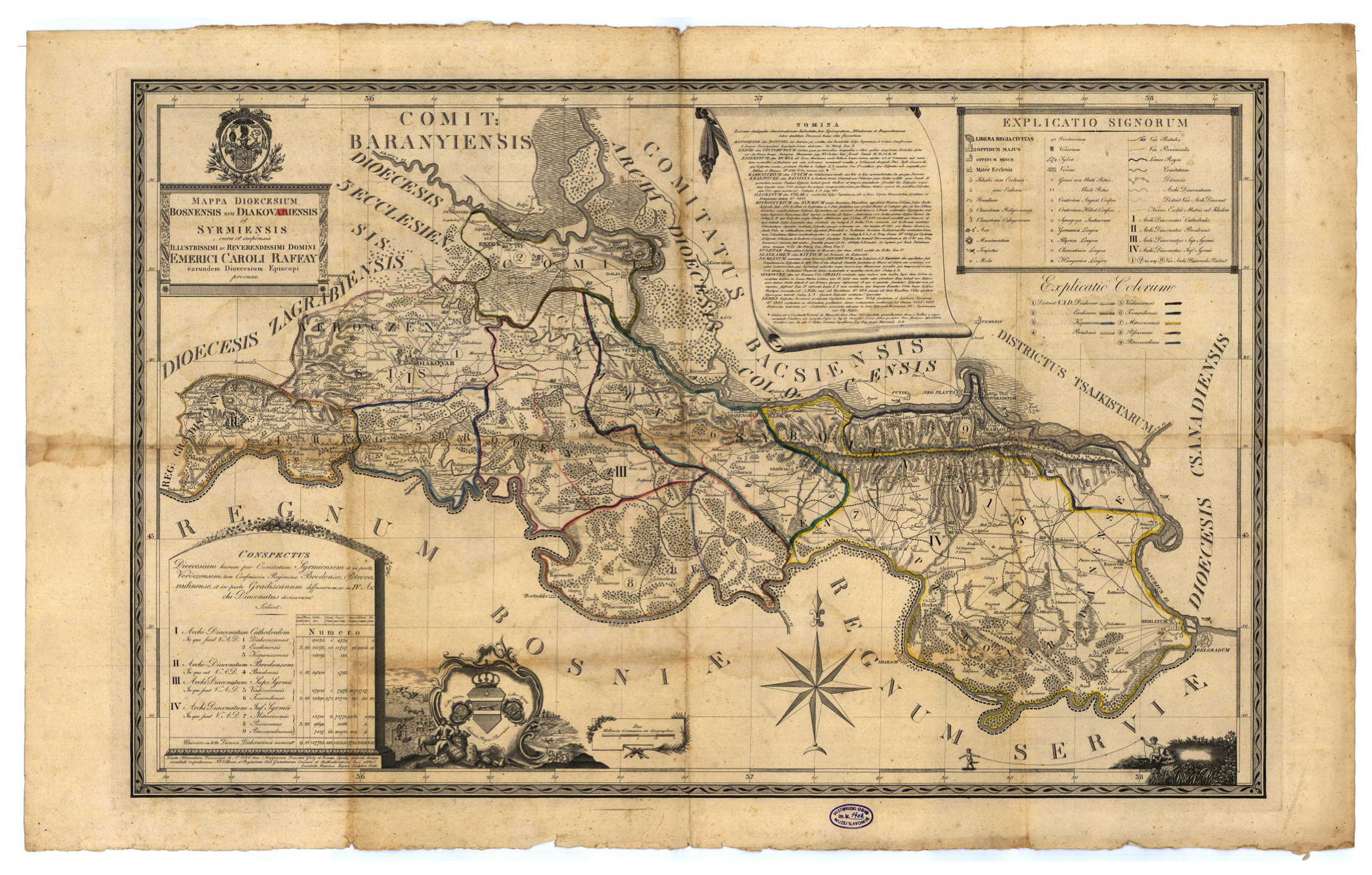
Figure 2. Original scan of the 1826 map: Mappa Dioecesium Bosnensis seu Diakovariensis et Syrmiensis [7].
Heritage 08 00356 g002
Figure 3. Preserved religious centers, shifts in parish structure, and boundary changes.
Heritage 08 00356 g003
Figure 6. Special thematic content on the map of the Požega Diocese.
Heritage 08 00356 g006
Figure 7. Example attribute table showing structured information for parish churches in the archdiocese.
Heritage 08 00356 g007
Table 1. Representation of the division on the map of the Bosnian or Đakovo and Srijem Diocese, 1826, into four archdeaconries and nine deaneries.
ArchdeaconryDeaneryParish
CathedralĐakovo
Osijek
Kopanica322
BrodBrod112
Upper SrijemVinkovci
Tovarnik225
Lower SrijemMitrovica
Posavina
Petrovaradin322
Total 981
Table 2. The distribution of specific cartographic symbols of religious significance across individual deaneries [7].
Cartographic SymbolHeritage 08 00356 i001Heritage 08 00356 i002Heritage 08 00356 i003Heritage 08 00356 i004Heritage 08 00356 i005Heritage 08 00356 i006Heritage 08 00356 i007Heritage 08 00356 i008Heritage 08 00356 i009Heritage 08 00356 i010


Deanery
Parish ChurchChapel with a ChurchChapel without a ChurchMonasteryConventOrthodox DenominationGreek Catholic DenominationLutheran DenominationCalvinist DenominationSynagogue
Table 3. Layers and sources.
LayerSourceFormatPurposeYear
Parish ChurchesArchdiocese websiteCSV/PointPoint features2024
Administrative BoundariesDIVA-GISShapefilePolygon deaneries2023
Historical DeaneriesGörög & Lipszky, 1826Raster and digitized vectorComparative analysis1826/2016
Disclaimer/Publisher’s Note: The statements, opinions and data contained in all publications are solely those of the individual author(s) and contributor(s) and not of MDPI and/or the editor(s). MDPI and/or the editor(s) disclaim responsibility for any injury to people or property resulting from any ideas, methods, instructions or products referred to in the content.