Article

Empty Shelves: Tracking the Flow of Goods During Ancient Climate Crises in Central Anatolia

1
Department of Sociology/Anthropology, State University of New York at Cortland, Cortland, NY 13045, USA
2
Department of Art and Archaeology, Hood College, Frederick, MD 21701, USA
3
Department of History, University of Calgary, Calgary, AB T2N1N4, Canada
4
C.H. Nash Museum at Chucalissa, University of Memphis, Memphis, TN 38109, USA
5
British Institute of Archaeology at Ankara, Çankaya/Ankara 06690, Türkiye
6
Institute of Egyptian Art and Archaeology, University of Memphis, Memphis, TN 38152, USA
*
Author to whom correspondence should be addressed.
Heritage 2025, 8(9), 354; https://doi.org/10.3390/heritage8090354
Submission received: 27 April 2025 / Revised: 23 July 2025 / Accepted: 25 July 2025 / Published: 2 September 2025
(This article belongs to the Special Issue The Archaeology of Climate Change)

Abstract

Archaeological investigations of ancient climate change have become an important focus for many researchers. A number of studies have focused on scientific techniques to identify the intricate details of the event, and the subsequent impact of these climatic changes on the ecological landscape. These more scientifically oriented studies have allowed the present authors to investigate a more subtle impact on the landscape: trade disruption during ancient climate crises viewed from the rural settlement of Çadır Höyük on the north central Anatolian plateau. The ebb and flow of trade networks in the past can be tied to many external sociopolitical and socioeconomic factors that may have had little to do with the air outside. We investigate here whether climate change was a significant factor that interfered with trade networks during three periods: The 4th millennium BCE Late Chalcolithic (the 5.2 ka climatic event); the late 2nd millennium BCE (3.2 ka climatic event); and the Medieval Warm Period from the 10th to the 13th century CE. This study presents the evidence for regular, and sometimes robust, trade or provision of goods and resources prior to these three climate events, and the disruption or dissolution of these during the height of each climate crisis, particularly in the earlier two periods; in the last period, climate variability was only one of many factors affecting trade networks on the plateau. We profile how the residents of ancient Çadır Höyük managed these intermittent “empty shelves” and filled in gaps using local resources and ingenuity.

1. Introduction

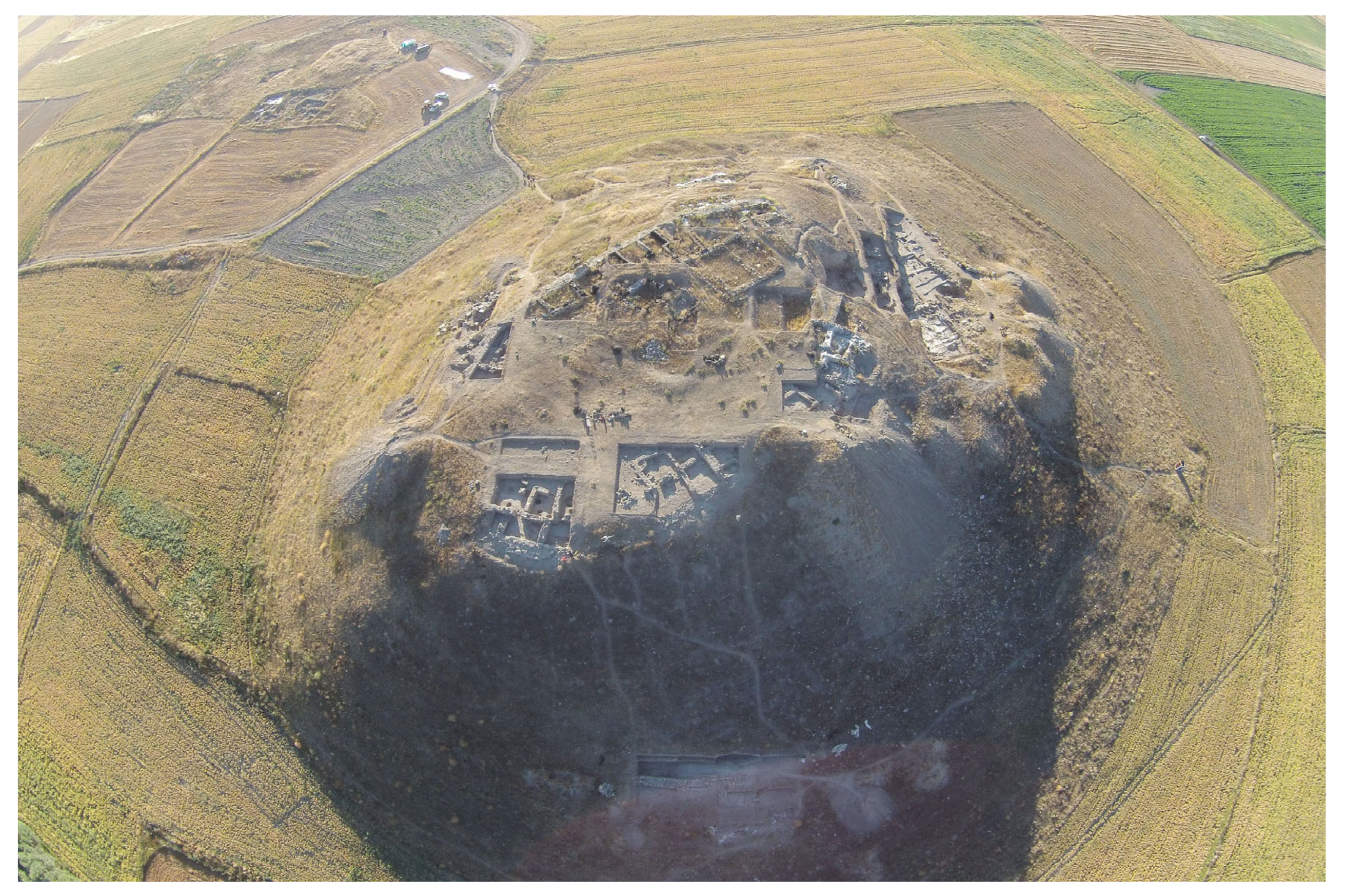
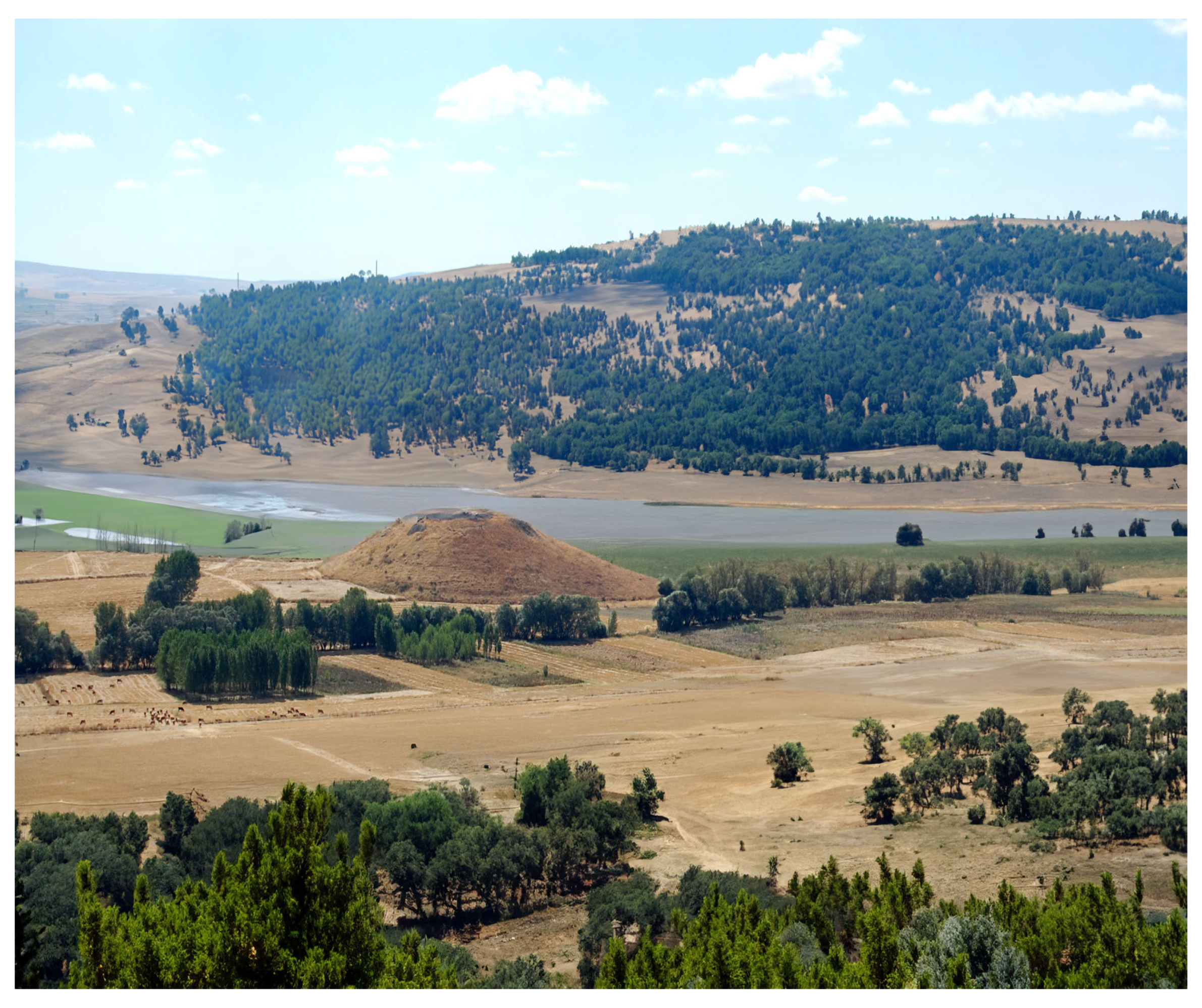
As the contributions to this theme issue illustrate, climate change affects every aspect of human life, no matter the time or place. This study investigates the effect of climate change on trade patterns at the site of Çadır Höyük in central Türkiye during three separate past climate events: the 5.2 ka event (3200 BCE); the 3.2 ka event at the end of the Late Bronze Age (ca. 1200 BCE); and the Medieval Warm Period (900–1200 CE). The site of Çadır Höyük, approximately 5 ha in size including the terrace, is located on the north central plateau in Yozgat province (Figure 1 and Figure 2). Multi-year excavations have documented a largely unbroken occupation at Çadır beginning at least as early as 5200 BCE, with final abandonment as late as the 13th century CE. During this time there were at least six climate events (Table 1); the three noted above are the focus here.
Long-term and meticulous excavations at Çadır have documented both minute and major changes in material culture distributions that signaled increased, decreased, or steady rates of local, regional, and long-distance trade relations. The waxing and waning of trade in these periods are also viewed in the context of regional and super-regional changes, some of which were loosely or primarily initiated by climate variability. The following study tracks this activity during periods of occupation that encompass the three intervals of erratic climate outlined in Table 1 (in bold). The data unequivocally demonstrate that climate change, which included increasing aridity and decreasing rain, impacted long-distance and regional trade for those living in this small, rural community, particularly in the earlier Chalcolithic and Late Bronze periods. In the Byzantine period, climate was only one of many factors affecting trade networks on the plateau. Though Çadır residents may have had to contend with intermittent “empty shelves,” they developed ways to fill in material culture gaps by employing local resources and ingenuity, demonstrating a resilience lasting through six millennia of occupation at this rural farming settlement.
Investigations of climate change and ancient settlements commonly begin with the examination of subsistence provisioning such as agro-husbandry patterns traceable through standard scientific methodologies including archaeobotany, zooarchaeology, and soil analyses. These types of studies have indeed been conducted at Çadır Höyük [8,21,22,23]. However, archaeological excavations rarely reveal the entirety of a community. Given the nature of the Çadır Höyük site, i.e., a steep-sided höyük (human-created mound), exposing an entire settlement, let alone one belonging to three different periods in time, is impossible. For this reason, only trends in agro-pastoral management strategies, alterations in socioeconomic patterns, and settlement size over time, can be suggested. Measuring the effects of these trends is possible only in broad terms given that the relevant data derive from less than 100% of the settlement. However, we have collected an enormous amount of data over the past three decades of work at Çadır Höyük; these data allow us to offer a series of “snapshots in time” that enable a localized and detailed view of lifeways at a rural settlement. Here we investigate the three episodes of climate variation, each involving significant aridification which had a variable, but largely negative, impact on trade networks in this small rural farming community on the Anatolian plateau.
These three points in time were chosen for analysis due to their correspondence to significant climate events and because we have robust material culture and architectural data from these occupational periods, acquired during our 30+ years of work at the site. We also have nearly 80 radiocarbon and bone collagen dates from critical contexts in these stratigraphic layers, allowing us to key these three settlement periods to the climate events. Prior to an examination of the Çadır Höyük material culture that serves as our proxy for trade during these periods, the data used to identify these climate events are briefly reviewed. In addition, the locations of desirable raw resources and the likely travel routes between these and the Çadır community are described. This tri-faceted approach presents a full picture of the trade process, from acquisition of raw resources to finished products recovered from excavations.
Archaeological analysis of trade patterns informs researchers about regional and long-distance networks, socioeconomic organization, community structure, and influence on sociopolitical patterns in a community; investigations at Çadır Höyük have demonstrated the intersection of trade with all of these factors during much of the site’s occupational history [24,25,26,27]. Recent archaeological and scientific analyses identify the enormous and usually deleterious impact climate change has on these social institutions. Previously successful trade systems declined due to disappearing products, more dangerous (ecologically and socially) trade routes, and the difficulty of obtaining increasingly rare resources. The literature on ancient climate changes causing major regional migration, and the demise of ancient complex systems and empires across the globe, is too voluminous to list. The same can be said for the present century, which has seen a growing corpus of studies on how global trade patterns will suffer from current climate variations (e.g., [28,29,30]).

2. Climate Events and Subsistence Adjustments at Ancient Çadır Höyük

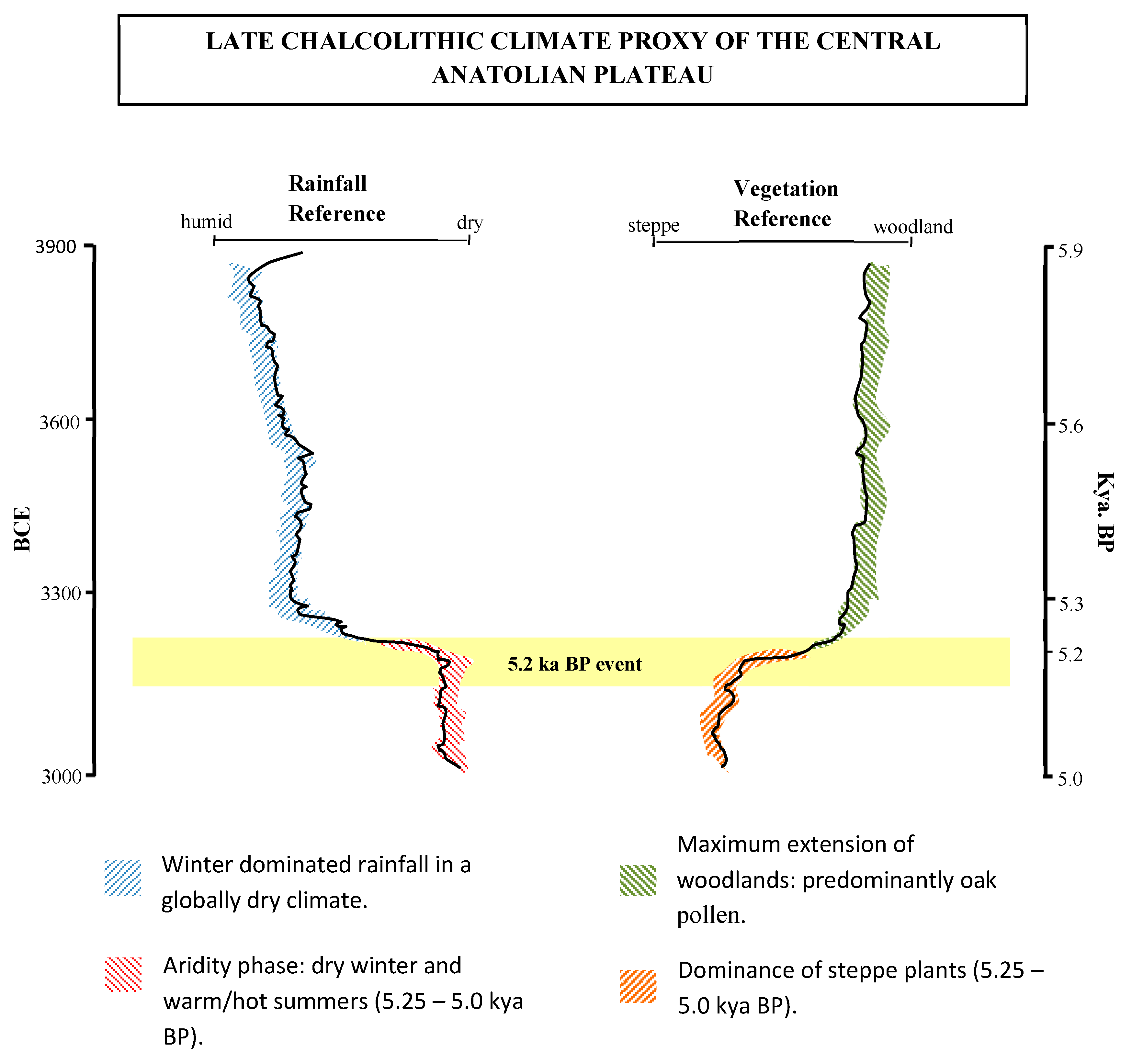
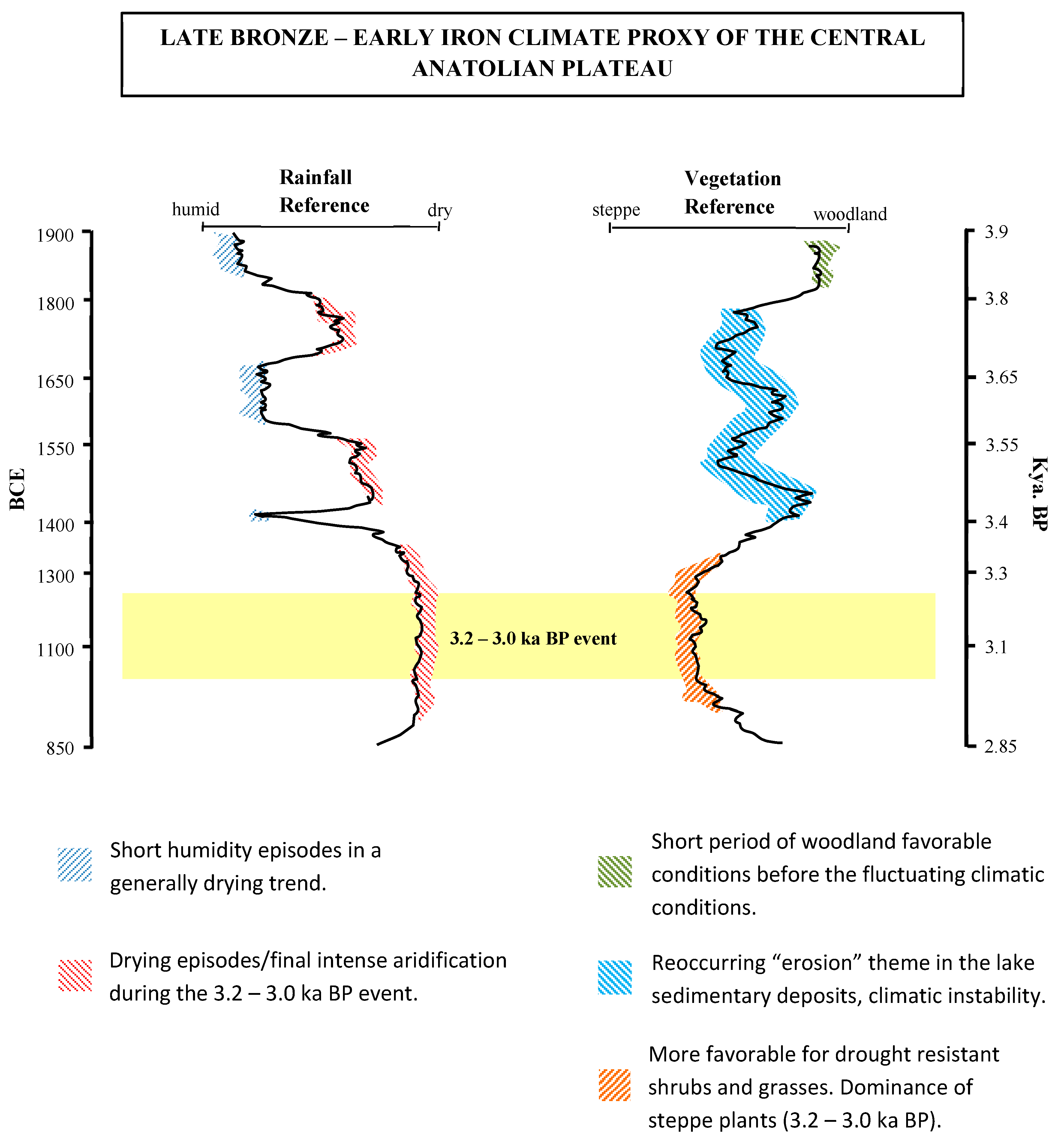
Common factors in the three variable climate periods examined include reduced rainfall—resulting in greater annual aridity—and variable but overall increasing annual temperatures. This section provides a more detailed description of each of these climate events. The diagrams and photos below are simplified visualizations based on paleoclimatic data and proxies from central Anatolia, including Tecer Lake, Nar Lake, Eski Acıgöl, and Lake Engir; they are all located on the central Anatolian plateau and can be regarded as suitable reference points for understanding the paleoclimate of Çadır Höyük. These diagrams are intended as visual summaries of the referenced climatic data associated with each of the major climate events.

2.1. The 5.2 ka Climate Event

There is a fairly substantial compendium of data documenting a climatic shift in Anatolia, and in fact across the eastern Mediterranean, in the late 4th millennium BCE (e.g., [3,5,17,31,32]). During the mid-Holocene, periods of aridity and decreasing rain occurred in roughly 500-year cycles, with one taking place near the beginning of the millennium, and another near the end, around ca. 3200 BCE; the latter is known as the 5.2 ka BP event. These data were derived from cave speleothems in Israel and Lebanon [33], lake cores and fossilized pollen samples in Anatolia [1,34,35,36], as well as syntheses of a variety of proxy data used to model climate fluctuations over the mid-Holocene millennia (ca. 5000–1200 BCE) [37].
The Tecer Lake core records a humid phase (3900–3300 BCE) indicated by a high intensity of clay deposition with numerous plant remains [34]. This long humid period corresponds with a dominance of woodland pollens [34,38] (Figure 3 and Figure 4). Lake sedimentation also records the following 300 years (3250–2950 BCE) when Tecer Lake dried up, demonstrated by the dramatic decline in percentages of calcite, organic carbon, clay, and silt [34].

2.2. The 3.2 ka Event

The 2nd millennium BCE witnessed climatic instability in central Anatolia, indicated by data that are also derived from lake cores [34,38]. These climatic shifts manifested as a general drying trend, known as the 3.2 ka event, which peaked between 1200–1000 BCE [14,16,39]. Over the millennium, rainfall and vegetation ranges indicate an increasing arid trend interspersed by short humid episodes (Figure 5). The Tecer Lake core displayed high but fluctuating values of aragonite and sand, pointing to a shallow and often saline lake [34,40]. Rainfall variations (Figure 5) are reflected in erosional patterns, such as the high sand input during the more humid intervals between ca. 1900 and 1800 BCE, 1650 and 1600 BCE, and ca. 1480 BCE, due to springtime snowmelt and precipitation. The “humid intervals” served only as phases of abatement; the drying trend continued, peaking between 1300 and 1100 BCE [34].
Sediment data from Nar Lake and Eski Acıgöl present corroborative evidence. At Nar Lake, moisture availability was at the lowest beginning in the late 3rd millennium BCE until 600 BCE, and Eski Acıgöl sediments document the driest periods occurring between 1250 and 250 BCE [38,40]. The lake core vegetation indicators (Figure 5) point to more drought resistant shrubs and grasses after recurring erosional periods during and after the 3.2 ka event [38,40] (Figure 6).

2.3. The Medieval Warm Period

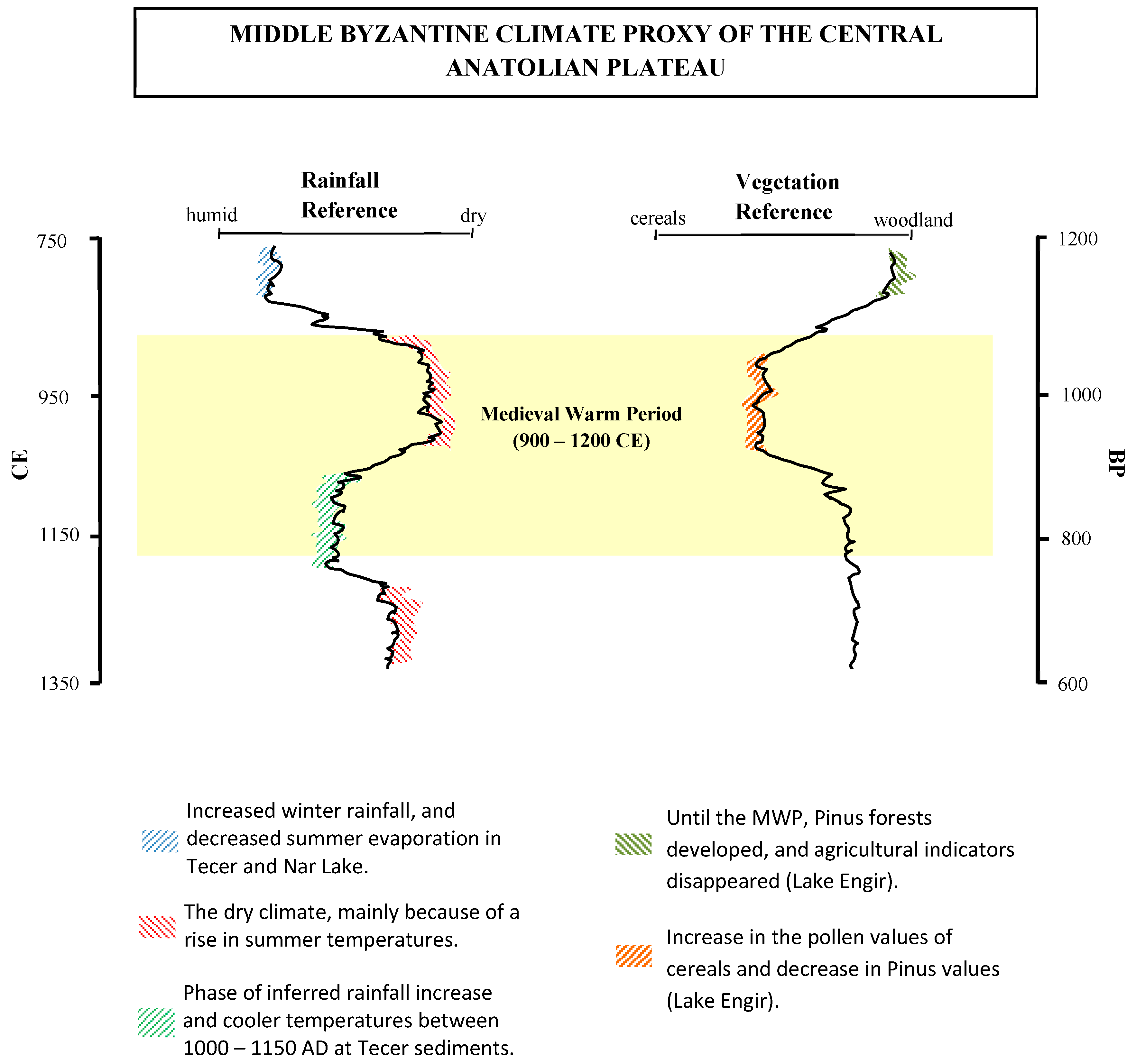
Between 850 and 1300 CE, there were a series of widespread climatic anomalies across Europe and northern Eurasia, referred to as both the Medieval Climate Anomaly and the Medieval Warm Period [19,20,41]. To narrow down the highest period of impact on the Anatolian plateau, this study relies primarily on the sedimentation data in cores acquired from Tecer Lake, Nar Lake, and Lake Engir [32,34,38,40]. While these data show that the Medieval Warm Period was not a globally uniform event, they help to narrow down the highest period of impact on the Anatolian plateau. The Tecer Lake core suggests high rainfall rates between 500 and 850 CE, indicated by accumulations of sand over the lake floor [34]. Data also suggest that the Medieval Warm Period began in 850 CE and ended in 1130 CE (Figure 7); Nar Lake sedimentation suggests a different situation, during which a regional drying phenomenon was apparent before ca. 500 CE. This was followed by relatively wetter conditions until 1350 CE. However, a comparatively dry period paused the generally more humid conditions that existed after approximately 750 CE, which lasted roughly 200 years [34,38,42].
Lake Engir vegetation data indicate that near the beginning of the Medieval Warm Period, cereal pollen values increased (Figure 7 and Figure 8), and Pinus values decreased in response to lowered rain supply. By 1200 CE the woodland landscape seems to have been re-established [32]. The entire climatic anomaly appears to begin around 900 CE with temperatures abating and a more regularized rainfall pattern occurring between 1100 and 1200 CE. This study examines trade patterns before 900 CE and during the period spanning 900–1200 CE.

2.4. Summary

Research at the site has always included intensive analysis of subsistence strategies (e.g., [43,44,45,46,47]), with recent analyses focusing more closely on how residents coped with these various climate events [8,21,22,48,49]. Zooarchaeological data are strong indicators of adjustments to animal husbandry patterns during these climate events. For instance, in the 4th millennium, Çadır residents began to dispense with the keeping of pigs, a water-loving animal that provided few secondary products [23,49]. More detailed analyses of our faunal data can be found in the discussions below.
The majority of the Çadır settlement’s agricultural fields were most likely located in the area between the mound and the river to the south. Over the years, Gelingüllü Lake, which was created by a dam built down river, has deposited several meters of sediment over what was prime agricultural land, severely limiting our ability to identify subtle land management activities such as ancient irrigation systems. Though Çadır residents consistently preferred wheat, or a wheat/barley balance, archaeobotanical analysis has demonstrated that during the height of the 5.2 ka episode, wheat, which generally requires a steadier annual rainfall, fell out of favor [22,23]. A pilot soil health study also indicates that soil health decreased during the 5.2 ka event, perhaps from heavier field use (e.g., lack of fallowing) [49]. In contrast, initial comparative archaeobotanical data corresponding to the 3.2 ka event suggest a steady wheat to barley ratio and an absence of soil health decline throughout the later 2nd millennium. Earlier standardization of fertilization and possibly irrigation systems during the Hittite Empire period may explain the greater stability during the 3.2 ka event [49].
During these three periods of fluctuating temperature and rainfall, the matter of groundwater may have become an issue. This possibility is based on current ethnographic work being conducted in the region. Farming families have repeatedly noted that springs and wells are severely depleted or entirely dry; deeper drilling is now continuously required to access groundwater for field irrigation [21]. It is perhaps likely that a similar depletion of groundwater in the past, either as decreasing availability, or as disappearance of easily accessed water sources, might have seriously impacted movement (trade) across an increasingly arid landscape.

3. The 4th Millennium Late Chalcolithic

The Chalcolithic occupation at Çadır is found only on the mound (approximately 2.3 ha in size), and thus far, only on the southern slope. To date, there are five Late Chalcolithic phases at Çadır (Phases V–I); Phases III–I are the focus here (Table 2). The Burnt House (“BH”) Phase III, subphases BH 3–2, occurred during a climatically stable period termed the Humid Intermission. The BH 2 subphase dates to the last several decades before the brunt of the climate event, though some climate variability may have already begun; we therefore term the BH 2 occupation the “Lead Up” period. The BH subphase 1 falls just before and at the beginning of the 5.2 ka event. The Phase II “Transitional” occupation spans the period during and just after the climate event. The Early Bronze (“EB”) Phase I occupation is situated in the aftermath of the 5.2 ka event, potentially a period of “recovery.”

3.1. Occupational Phases: Description

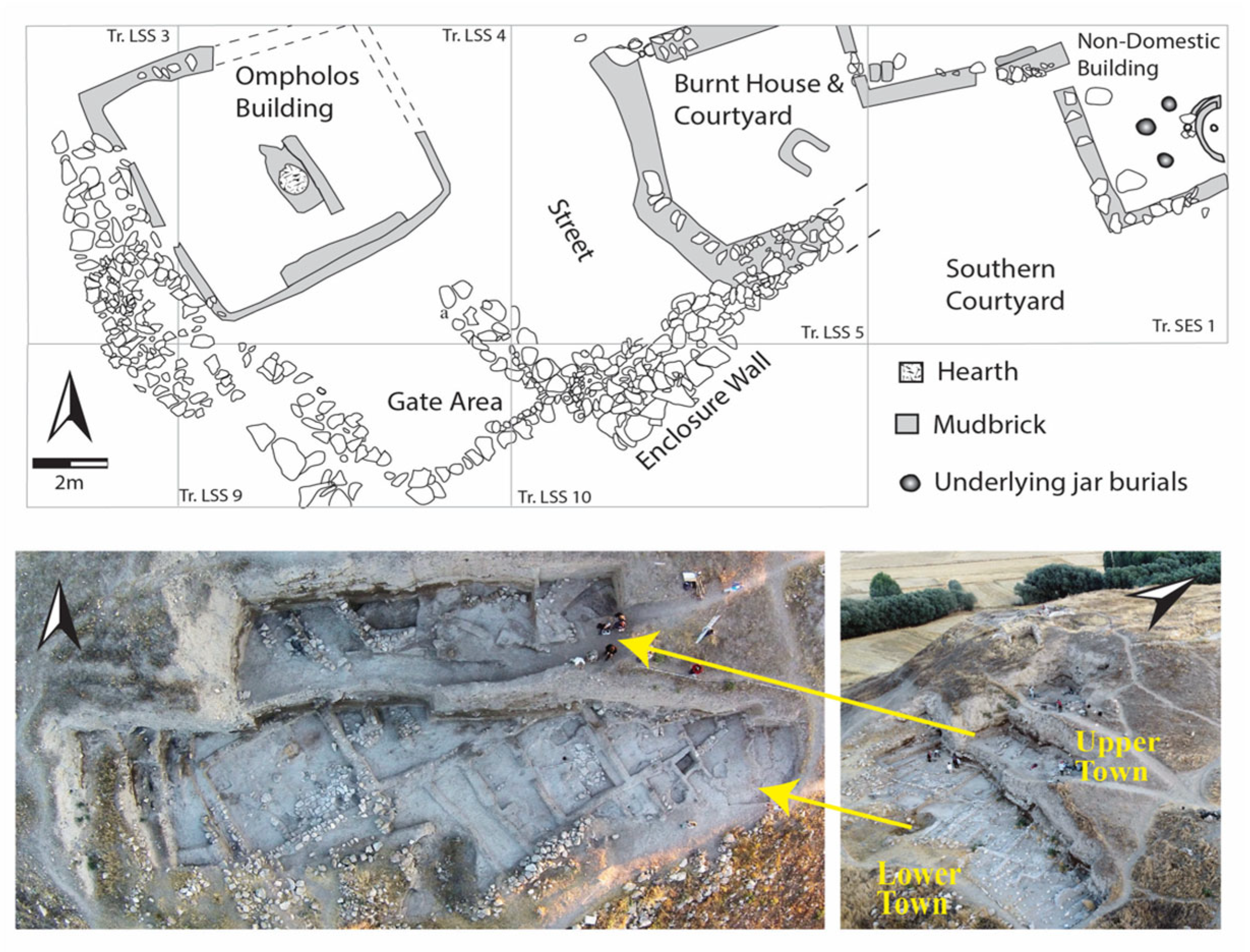
The majority of the Phase III BH (Humid Intermission/Lead Up) occupation saw a thriving Late Chalcolithic community composed of Eastern, Western and possible (currently unexcavated) Northern Compounds in the “Lower Town.” At least one additional compound in the “Upper Town” (a terraced occupational level ca. 1.5 m above the Lower Town) was built during this phase [21] (Figure 9). The BH 3 Western Compound featured a ceramic production area (“Ompholos Building”) which also functioned as a ceramic distribution center in BH 2 [50,51,52,53]. During subphase 2, a substantial Enclosure Wall and Gate system was constructed south of the settlement [25,54]. The gate led into a “street” separating the Western and Eastern Compounds with broad terraces rising to the Upper Town.
The BH 3–2 Eastern Compound was entirely domestic, comprising a residence known as the Burnt House, accessed from the street via a western courtyard [52,55]. Material culture in the courtyard included tools and materials associated with ceramic, lithic, and textile production [56]. East of the Burnt House was a “Non-Domestic” area that likely served a ritual purpose for the community [57,58]. A final notable area in the Lower Town was the “Southern Courtyard,” which featured several hearths and work areas primarily for food processing and the production of pottery. It appears to have been accessible to the community, but may have also been partially or wholly supervised by the Burnt House residents [51,52,56].
The BH 1 Onset period saw the Lower Town slowly fall out of use and the gate blocked. By the subsequent Phase II Transitional height of the 5.2 ka period, the entire Lower Town was relegated to storage and some production activity (mainly lithics and textiles) [56]. In the EB (Phase I) Recovery period, small, rickety, rectangular structures were built, possibly as storage facilities. The Upper Town Transitional and EB periods saw a far more robust occupation, with work areas and ceramics production, including probable kilns. A large EB wall was built to surround the Upper Town community [56,59]. The Lower Town was effectively out of use by this period except for storage and temporary housing facilities.

3.2. Trade During the Late Chalcolithic 5.2 ka Event

At the center of the Chalcolithic materials analysis are obsidian, copper, and textiles. Metal and obsidian are present in measurable quantities throughout the target periods, and the production of textiles, ostensibly at levels sufficient for trade, is inferable through tracking herd ratios and slaughtering patterns.
In the 3rd millennium BCE, a major east–west trade route [60] likely passed somewhere north of the modern city of Sorgun, which rests 16 km north of Çadır Höyük. It is quite possible that this route was also used in the 4th millennium, with smaller networks connecting it to Çadır and nearby contemporary sites, such as Alişar Höyük and Çamlıbel Tarlası. As at Çadır, the Chalcolithic occupation at Alişar Höyük is found only on the mound. Alişar Höyük consists of a 3 ha mound with a surrounding terrace; overall the site is slightly larger than Çadır, while Çamlıbel at 0.25 ha is far smaller (other nearby unexcavated Late Chalcolithic sites identified in survey [61], such as Orta Höyük and Küçük Höyük, are smaller, at 2 ha and 1.44 ha, respectively). It is unclear whether residents at Çadır and neighboring sites traveled along the northern trade routes to obtain raw resources or awaited traders and “deliveries” to their communities.
The modes of transport for traders in the 4th millennium were limited. Though wheeled carts had likely been invented by the middle of the millennium [62], they may not have been widely used until somewhat later. The widespread presence of domesticated donkeys on the Anatolian plateau is not evident until well into the 3rd millennium [60,63]. The primary mode of transport available to traders, therefore, was likely human power. On average, depending on terrain and available resources such as food, water, and shelter, humans can travel approximately 25 km/day, somewhat less if heavily laden. It is this calculation that will determine journey-days in the discussion below.

3.3. Lithics

The lithics at Çadır Höyük are categorized here as “chert” (which includes chalcedony and jasper) and “obsidian.” Weight calculations included recognizable tools, flakes, and cores; collections of debitage were excluded. Scientific analysis of chert sources has not been conducted at Çadır, though a regional survey has provided some indications of raw resource locations. Data on chert and obsidian sourcing are described in more detail below.
In the 4th millennium, chert was the primary tool-making material at Çadır Höyük (Figure 10). A regional survey identified small chert and jasper cobbles (50–89 mm in size) 2 km away in a river drainage [54]. Geochemical studies in the Yozgat province identified large chert/chalcedony deposits located to the north [64,65,66], the closest of which are ca. 50 km away from Çadır. The easy two-day journey to these sources would lead through landscapes similar to that surrounding Çadır, which featured hills and valleys of open steppe interspersed with pine/oak forests, streams, and natural springs. While “local” in nature, the retrieval of raw chert by Çadır residents or the distribution of these by regional traders required some effort.
Obsidian is plentiful in Anatolia, but the closest sources are at Acıgöl, Göllü Dağ, and Nenezi Dağ in Cappadocia, some distance from Çadır Höyük (see Figure 10); pXRF analyses suggest that Çadır’s obsidian indeed came from these sources [67]. The 180 km journey to Cappadocia would require an approximately seven-day trip. Traders between the two locations would likely have traveled through landscapes similar to that around Çadır as well as through river valleys. The Cappadocian landscape, even today, is considered somewhat arid; secure water sources would have been vital along the route.
Figure 11 charts both a visual ratio of obsidian to chert at the site and the associated weight data; also shown is the percentage of obsidian in each assemblage. These data indicate significant changes just before and during the 5.2 ka event. In the more climatically stable (Humid Intermission/Lead Up) BH 3–2 subphases, the sheer amount of chert and obsidian present at the site demonstrates robust lithics production. It is likely that lithics were produced at capacities beyond household and community needs, perhaps at levels contributing to local and regional trade [51,52]. Obsidian made up over a quarter of the entire assemblage during this period. During the BH 1 “Onset” period, the amount of obsidian in the assemblage drops considerably; the distribution of tools, cores, flakes, and debitage in the Lower Town suggests that knapping activities, and possibly tool storage, were occurring at this time [56]. During the height of the 5.2 event (Phase II Transitional), the amount of obsidian decreased again, to 7%. In the EB “Recovery” period, there is a modest but noticeable increase of obsidian in the assemblage (15%), which might suggest that the residents were reconnecting to trade networks for this important raw resource.
These patterns suggest that obsidian trade declined rather significantly in the periods just before and during the 5.2 ka event. While this was expected, what came as a surprise was the apparent decrease in the amount of chert present in these assemblages. While the substantially lower weight in BH 1 may be partially due to its short (two generations or less) timespan, lower weights of lithics continue into the longer Transitional phase, suggesting that acquisition of raw resources may have become more limited. Both Phases II–I last roughly two centuries, and yet, they show a substantially different presence of lithic material. An accident of excavation areas may be the simple cause of this discrepancy. Another possibility is that even the acquisition of chert, especially during the peak climate event, grew more difficult. Studies to examine whether there was extensive reuse of all tools at this time are beginning. The EB Recovery period shows a substantially higher weight total possibly reflecting a reconnection to trade networks for this important raw resource.
The significant decrease in obsidian at Çadır Höyük during the 5.2 ka episode suggests that climate change may have figured prominently as a causative factor. The multi-day journey to Cappadocia would have required the surety of finding water along the way, making freshwater replenishment from potentially declining sources more precarious. Residents at Çadır may have thought twice before straying too far from home, and traders carrying obsidian nodules may have traveled routes closer to Cappadocia, turning it into a “rare resource” on the north central plateau. The two-day journey to chert sources was more manageable, but weight counts suggest that even this trek became less desirable during the 5.2 ka event.

3.4. Metals

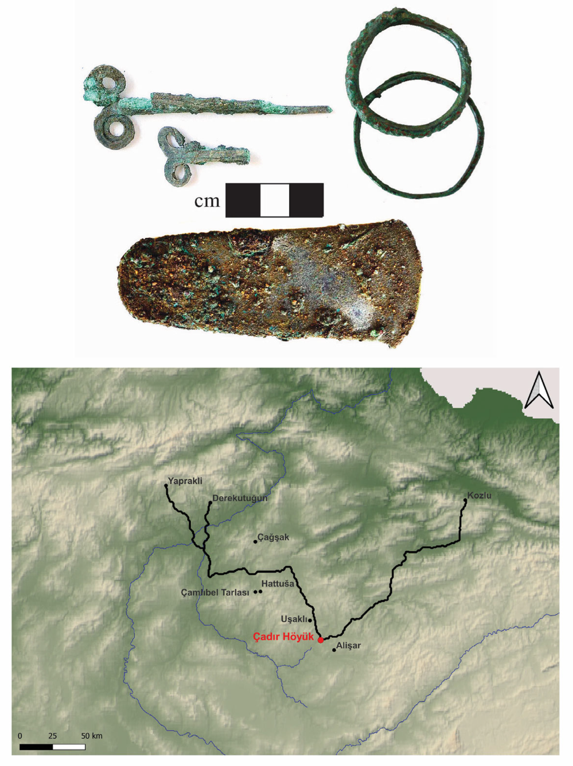
Unlike obsidian or chert, which can be considered primarily utilitarian, metal was more of a luxury item in the Late Chalcolithic. At Çadır Höyük, the most common metal artifacts were copper pins, needles, and jewelry (Figure 12), all of which could be fashioned with other materials, such as bone or shell. Possessing copper items was likely a status marker. Copper pins and needles were scattered throughout the settlement while jewelry (bracelets, hair slides, rings) was primarily found in infant and child burials in both the Eastern and Western Compounds [57,58]. Our most remarkable metal find was a copper axe recovered from the Non-Domestic area. There is currently no indication of 4th millennium copper-working at Çadır Höyük. It would appear that copper-based items arrived in finished form via an active trade network.
There are various zones of copper ore sources scattered across the northern plateau [68]; some are native (pure) copper ores and others are arsenical copper. Zones include the Yapraklı district northwest of Ankara (some native ore sources) [31,59], and the southern Pontic Mountain belt at the northern boundary of the plateau [69,70]. Some evidence of 3rd millennium BCE copper mining activity was discovered at Kozlu northwest of Tokat (mainly arsenical copper ores) [69,71,72]. Evidence of Chalcolithic mining activity of native copper was discovered at Derekutuğun in the Çorum district [73,74,75]. These sources range from 195 to 230 km from Çadır (Figure 12); the closest (Kozlu) required a roughly 8-day journey. The best route between Çadır and the closer metal sources crosses similar landscapes to those described for chert. To reach sources further north, traders would have to cross a broad open valley and the Delice Irmak River valley. Regular water supply points would have been essential on portions of this journey.
There is evidence of copper smelting at Çamlıbel Tarlası, located near the later Hittite capital, Hattuša. Çamlıbel was occupied from ca. 3590 to 3470 BCE [76], which corresponds to the BH 3 subphase at Çadır. Metallurgical activities took place throughout the occupational period there [76,77]. A survey of the region identified chalcopyrite vein fillings in basalt deposits just 2 km from Çamlıbel, which appear to be native copper [78,79]. Analyses of the slag indicate that Çamlıbel residents were making use of these nearby copper resources. However, the finished metal artifacts also contained arsenical copper, suggesting that local copper was alloyed with arsenical copper ores [79], possibly retrieved from the more distant sources, such as those described above. Çamlıbel Tarlası is much closer to Çadır, an easy 2-day journey, and may well have been part of a regional trade network.
Figure 13 shows the dramatic decrease in the presence of metal (as indicated by weight, in kilograms) at Çadır Höyük as the residents approached and then endured the 5.2 ka climate event. Unlike the rise in the acquisition of chert during the Recovery period, metal remained scarce. The data suggest that the metal/ore and finished product supply lines to the Çadır community became far more limited just prior to, during, and after the 5.2 ka event.

3.5. Textiles

The availability of textiles for trade is difficult to assess due to two main obstacles. The first is that some textiles were likely produced from plant fibers such as flax, as was the case at Çamlıbel Tarlası [80]. Flax, however, is present in only small quantities at Çadır. The second obstacle is that zooarchaeological data at Çadır has been recovered from only a percentage rather than the totality of the settlement, making it difficult to determine the size of the herd through time, even if the ratio of species within the herd can be tracked. Nonetheless, a brief summary of our faunal analyses suggests that caprines at Çadır Höyük functioned as a critical source of secondary products throughout the periods under discussion, and as a consequence, residents may have served as producers of textiles to contribute to a dwindling trade network as the 5.2 ka climate event wore on.
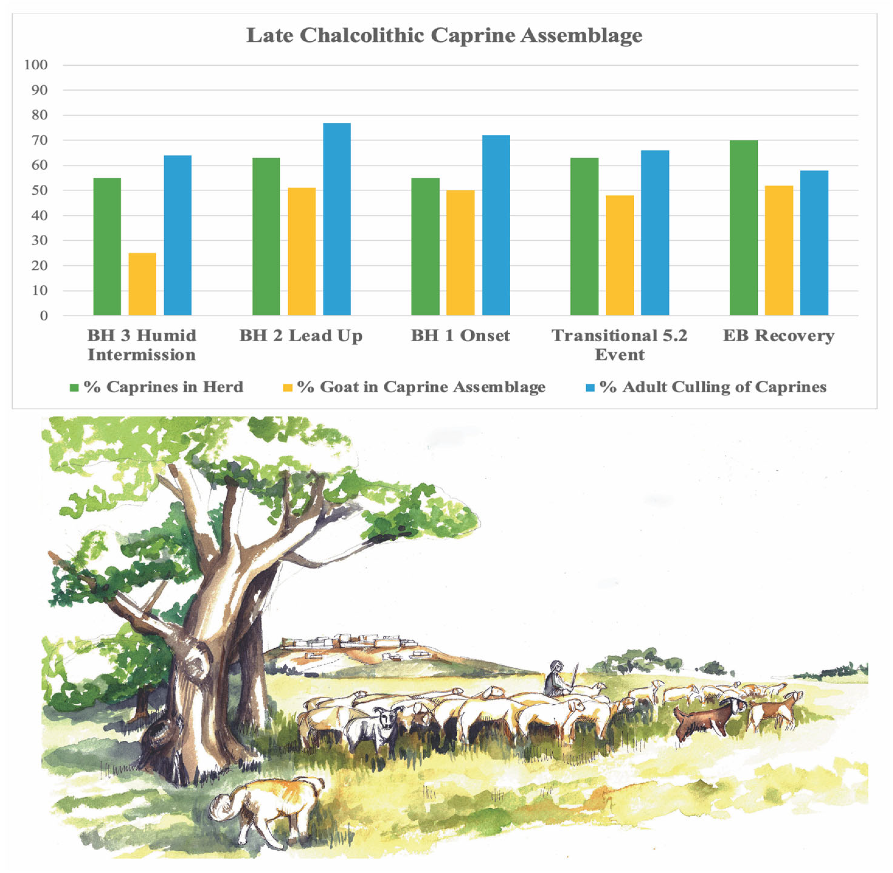
In the BH 3–2 Humid Intermission/Lead Up periods, tools associated with textile production were a regular occurrence across the domestic Eastern Compound [56]. At this time, well over half of the herd assemblage consisted of caprines (Figure 14), of which nearly three-quarters were sheep [23]. Elsewhere, we have discussed the importance of wool trade with regions southeast of Çadır in the mid-4th millennium [51,52], which may explain the substantial sheep presence in the herd. In BH 2, the caprine percentage reaching adulthood increased substantially, indicating an importance of secondary products. The percentage of goats also increased; residents may have been experimenting with adding goat-hair felt production to their textile trade (Early Iron Age contexts have offered evidence of felt production at Çadır Höyük) [26,81].
In the shorter BH 1 Onset period, caprine percentages decreased somewhat. Adult culling remained steady at three-quarters of the herd, indicating a continued importance of secondary products in the community. During the 5.2 ka event in the Transitional period, caprines again increased in the assemblage, with sheep still dominating. A majority of caprines survived into adulthood. Though the human population had moved to the Upper Town, there is extensive evidence of tools associated with textile production in the former Lower Town Eastern Compound courtyards. In the EB Recovery period, the caprine portion of the herd increased again; the sheep-to-goat ratio remained largely in balance, with adult culling dropping [49]. Textile production continued to take place in the Lower Town, and for the first time, extensive evidence of production tools is found in the Upper Town [56].
Secondary-product provisions from the caprine herd, especially fibers for textiles, were perhaps far greater in quantity than that needed to supply the relatively small Çadır community. Wool and felt may have been employed as trade products throughout the 4th millennium. The prominence of goats, which can range more widely for food and require less water than sheep, may have also reflected a more careful herd management strategy in an increasingly variable climate. Whether the size of the overall herd decreased during the 5.2 ka event is not known.

3.6. Summary

The lack of excavated Late Chalcolithic sites in the region surrounding Çadır Höyük does not allow us to assess whether regional trade suffered at the time of the 5.2 ka event. Çamlıbel Tarlası was not inhabited at this time, and Alişar’s exposure is too small to assess trade involvement, or lack thereof. The few other very small sites discovered in our survey have not been excavated, so our understanding of trade networks in the region during the fourth millennium rests primarily on data from Çadır Höyük. The microscale excavations at Çadır allowed a detailed analysis focusing on the acquisition and possible distribution of utilitarian or luxury items over the course of the climate event. Data on obsidian and copper suggest a potential “empty shelves” situation; Çadır residents may have had little control over supply lines for these materials. There was some success at maintaining the acquisition of chert resources which were possibly procured by residents themselves. Evidence suggests extensive management strategies concerning the production of textiles; these potential commodities may have helped residents stay connected in what were likely quite diminished trade networks.
Though Çadır residents could “do without” metal, lithics were another matter. The drastic reduction in the chert/obsidian weight during the greatest climate variability period may have many explanations, including a reduced population (or one relocated to an as yet unexcavated Upper Town), though the far larger lithics weight in the Recovery period provides evidence that seems to refute these. Alternatively, stone tools used for some tasks could have been replaced by wood, bone, or even ceramic tools [82], but knives, blades, and projectile points really require stone. Careful reuse and reshaping of knapped tools could have become something of a cottage industry at this time. A detailed analysis of reuse/retouching may yield answers. The steady presence of a caprine herd, the products from which may have provided goods for local trade systems, and careful crop management strategies, allowed the Çadır residents to “weather” the 5.2 ka event into the Bronze Age, only to find themselves in the midst of additional episodes of climatic alterations in the 3rd millennium.

4. The Late Bronze Age and Early Iron Age

A significant amount of archaeological information from the central Anatolian plateau is available on the 3.2 ka climate event, a time that coincides with a set of larger-scale disruptions and collapses across the eastern Mediterranean at the end of the Bronze Age. In Anatolia, this change contributed to, but was not solely responsible for, the decline and disappearance of the Hittite Empire. Çadır is one of many mound sites in the area with evidence for occupation during the Hittite Old Kingdom (1700–1500 BCE) and Empire period (1400–1180 BCE); Hittite texts indicate that the central government, located about 70 km away at Hattuša (modern Boğazköy), administered towns within its core region in a variety of ways. Given its size, Çadır is likely to have been subordinate to one of the larger settlements in its vicinity, either to Uşaklı Höyük (10 ha in size) to its north or Alişar Höyük (at this time, possibly over 18 ha including its terrace) to its south [83,84,85], or perhaps to both.

4.1. Occupational Phases: Description

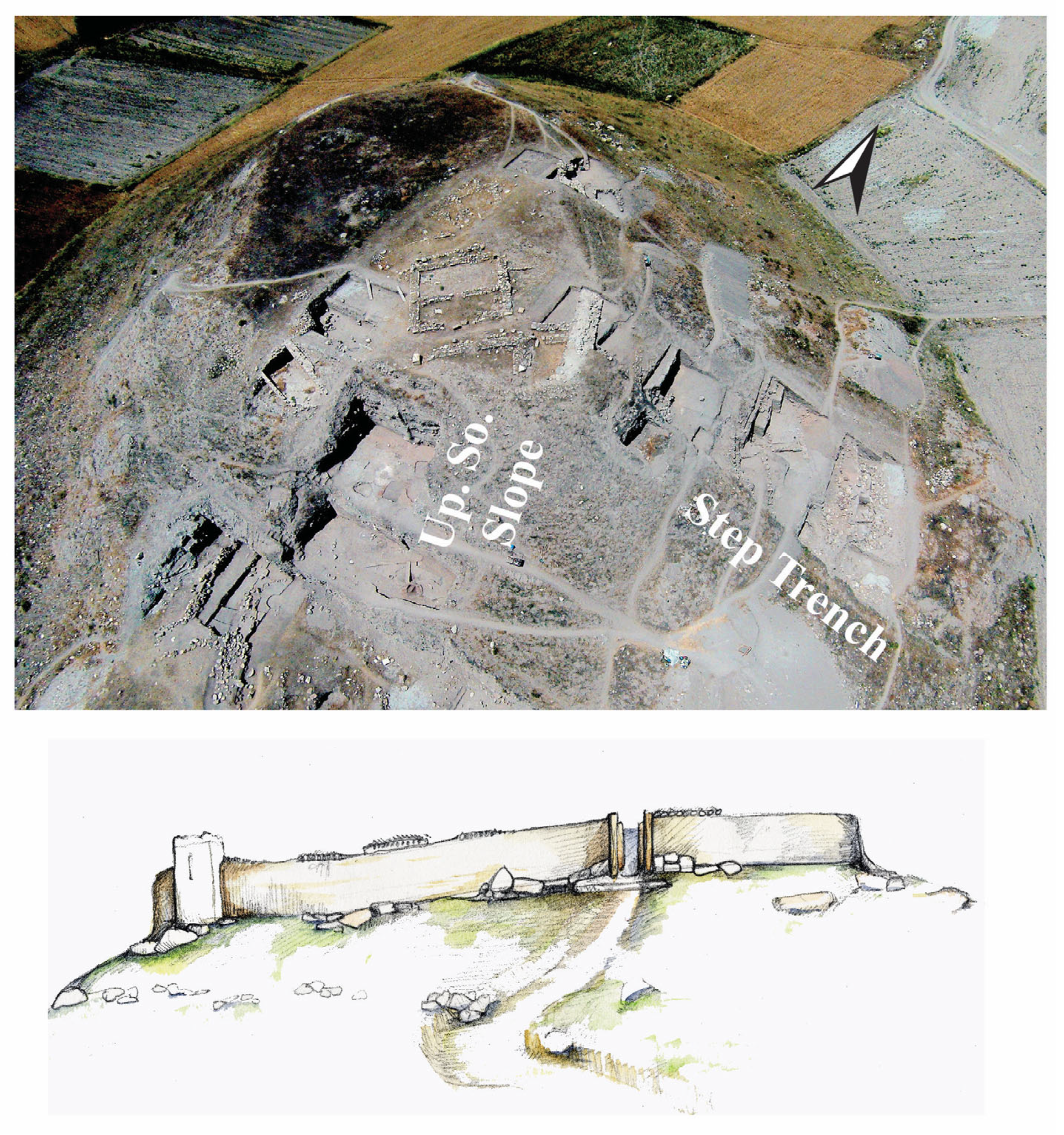
Çadır was occupied throughout the 2nd and 1st millennia and thus during the 3.2 ka event. Evidence for Hittite-period/Late Bronze Age occupation has been recovered predominantly in the Step Trench on the east side of the mound (Figure 15, top), where architecture and material culture of the Hittite Old Kingdom and the Empire period is spread over at least 400 square meters [53,54,59,86]. More limited exposure on both the north and south slopes of the mound has also revealed Hittite-era remains; following the 3.2 ka event, occupation in the Early Iron Age (1180–900 BCE) has been attested in situ only on the upper southern slope [26,27,81,82].
Precise dates for the Hittite-period occupation in the Step Trench are still in flux; recent C14 results required significant revisions to the dates of specific phases based on samples run in 2024 [87]. This new evidence indicates that the eastern slope of the mound, or at least a significant portion of it, was fortified in the mid-2nd millennium Hittite Old Kingdom period; these fortifications were of impressive size, and modified multiple times. They included a 3–4 m wide casemate wall and tower (Figure 15, bottom); a gateway with massive stone foundations on the northern side of the mound may belong to the same phase, or to later during the Late Bronze Age phases (see below). These fortifications were probably repaired, strengthened, and reused during the Empire period.
Inside the wall in the Step Trench are additional architectural remains, many of them belonging to the Hittite Old Kingdom, and some post-dating that. Buildings were relocated further inside the walls during the Hittite Empire period, but no free-standing or fully-excavated structure from the Late Empire period has yet been explored as these lie below the Byzantine Upper Town. The northern gateway’s orientation toward both Uşaklı and Boğazköy may indicate a new or renewed focus of attention toward political and religious sites to the north (Figure 15, bottom). Buildings within the walls on the east side of the mound were well-built, with significant attempts to level or terrace the sloping ground, and stone foundations atop which were mudbrick walls.
Toward the end of the Late Bronze Age, new occupation levels on the upper southern slope of the mound indicate a significant change in the nature of occupation. Here, a tall mudbrick perimeter wall stood during the Hittite Empire, though without the stone foundations typical elsewhere on the mound. Built into the superstructure of this wall were workspaces that reused the wall in support of activities that required heat/fire. One facility of uncertain function was rebuilt twice after its original use, the final time with the addition of a finely polished plaster surface surrounding a small burnt depression (visible in Figure 15, top). None of these features attest to the prolonged firing or baking activities of a kiln or oven; they seem to have been subject to short-term use. The only burnt material found in association with them consisted of animal bones that had been calcified beyond identification. This phase, as will be described in greater detail below, includes major material culture changes.
While post-Hittite empire occupation during the Late Bronze Age occurs at a limited number of sites on the plateau, Çadır is one of the only sites demonstrating continuous occupation through the collapse period and into the Early Iron Age (see below). During the Early Iron Age, which dates to just after the 3.2 ka event, the work areas for manufacturing processes expanded but likely shifted in function. Rather than a set of heat-based facilities, the southern slope at this time featured a series of open-air, rounded, plastered depressions, usually 1–2 m in diameter and 10–15 cm deep. Sometimes, low stone wall segments separated these installations from one another; in other locations, smaller pits surrounded larger ones. The only consistent contents were large pieces of charcoal or charred wood, but without evidence that substantial burning took place within the pits (they were not hardened by repeated or sustained heat). The care taken in the creation and maintenance of these frequently replastered features argues against a use for rubbish disposal. Based on similar but later Middle and Late Iron Age features in the same trench, which were associated loom weights and other textile production evidence, we have proposed that these Early Iron Age work areas were devoted to the production of leather and felt items [81]. Such a function would explain the ubiquitous presence of animal bones (see below).

4.2. Trade in the Age of the 3.2 ka Event

Hittite texts from Boğazköy and provincial centers offer a great deal of information on the basic workings of the Hittite imperial economy and on the central government’s relationship with local centers. The focus of these texts mostly concerns how the economic workings of the local territories benefited the political and religious center. They also include reports from the countryside, where local religious festivals were observed by government officials [88].
The archaeological evidence afforded by sites like Çadır is no less illuminating. Residents at the site during the Empire period pursued an agro-pastoral economy, providing for most of their own dietary needs. Hittite economic texts suggest that rural centers also provided significant numbers of animals and animal products to the government, with a focus on meat-heavy large animals like cows [89,90]. Rural settlements were also responsible for provisioning the king and royal court when they traveled from Hattuša to celebrate annual festivals. For Çadır’s residents, that probably meant sending animals, dairy products, and other foods to larger towns with temples, like nearby Uşaklı Höyük. Faunal evidence from Hittite Empire contexts indicates that the local residents kept cattle and caprines; survival rates to adulthood in both categories suggest the importance of secondary products in this period [48].
Non-local materials during the Hittite Empire period at Çadır Höyük appear in small numbers, and are indicative of a moderate level of engagement in the larger political and economic sphere. The range of fabrics found in 2nd millennium ceramics is probably greater than would have been typical for local potters; instead, a wide array of combinations of clays, grit temper, mica, and crushed ceramics (grog) is probably due to ceramics arriving at the site (with or without contents) from other places. The same variety is typical of the forms as well. Cannon suggests that people from surrounding smaller settlements may have gathered at Çadır for religious festivals, bringing offerings and pots for their own use [91].
Coming from greater distances were metal (copper alloy) pins, beads, and other ornaments (Figure 16). The nearest copper source to Çadır is to the north [74] (see Figure 12), so the raw material may have passed through the political center at Ḫattuša and been shaped there into particular forms before being disbursed or sold to places further south. Obsidian, found in quantities that were much smaller than in the Chalcolithic levels, but still significant to the production of tools, would have come from the opposite direction (see Figure 10).
Other objects of more luxurious types and uses may have also arrived as gifts or precious belongings of the leaders and wealthiest residents at Çadır; these provide evidence of additional connections to the imperial capital. These included bone and possibly ivory objects of uncertain use, such as a long trimmed shaft culminating in the head of a bird (perhaps a pin), and bone overlay or segments from wooden objects like furniture (Figure 16). The earlier Hittite-period levels also yielded stone stamp seals of types found also at Boğazköy and Alişar [85,92] (Figure 16). These seals, which are engraved with geometric, floral, and animal designs, attest to involvement in administrative activities by residents of the site. While no clay tablets have been found, Çadır officials may have used their seals on door closures, to control and protect items in storage, or on vessel closures or bullae accompanying objects being sent to another settlement. These objects attest to connections with other production centers, and the supply of materials and goods beyond the immediate locality.
The closest parallels to the material culture of Hittite-period Çadır come from Alişar, a far-larger Hittite center of this time, with evidence for administrative functions in the form of cuneiform texts and larger numbers of excavated seals [85]. Those similarities extend to the presence of a hoof-shaped stamp seal with curving herringbone designs at both sites, and similar griffin designs as central seal devices. Çadır is so far missing seals bearing inscriptions, suggesting a more marginal location vis-à-vis central Hittite administration. Both Alişar and Çadır also feature bone plaques with carved concentric circle designs that came from boxes or furniture; these suggest a degree of luxury production, gift-giving, or access to the same suppliers.
In the years just prior to the 3.2 ka event, evidence from sites throughout central Anatolia suggests that the Hittite Empire was already losing its grip on territories close by, and even at the capital city itself [93]. Just after the collapse, there was a general abandonment of settlements across the plateau; these settlements may have previously acted as suppliers and consumers of Hittite trade items. This trend can be seen at sites near Çadır Höyük, such as Uşaklı Höyük and Alişar Höyük. At the latter site, the next recognizable occupational layer dates to the Middle Iron Age, suggesting an Early Iron Age abandonment; at Uşaklı Höyük, ceramics identified as Early Iron Age have been collected, but settlement remains above those belonging to this period are lacking [85,94]. At Çadır Höyük, the short-lived pyro-technological facility on the upper southern slope belonged to that period. Relatively few objects come from the levels belonging to this transitional period, compared to the contents of the Hittite Empire period contexts. Specifically, ornamental and administrative items disappeared. Very few metal objects were present, comprising just a couple of pins or nails, and a small copper alloy bead. The stone tool assemblage includes groundstone objects (from local granitic sources), chert, chalcedony, and a small amount of obsidian. Bone tools also appeared in these layers. Significantly, a wide array of shaped sherds (into various types of tools) also occurred, suggesting that the residents repurposed available materials to substitute for raw materials to which they no longer had access.
Finally, in the Early Iron Age, after the climate crisis had passed, Çadır rebounded in terms of the intensity of manufacturing activity and, presumably, other economic activities. Supplies of luxury items appear to have been more limited than previously, but copper-alloy objects were found in significant numbers, and in forms (pins and beads) familiar from previous periods. Recent NAA work indicates that Çadır shared ceramic wares, and even possibly clay sources, with nearby Alişar during the Middle Iron Age [95]. Previous testing revealed a wide range of compositional groups at Çadır during the Middle and Late Iron Age (and increasing with time), suggesting some movement of ceramics into the site [96]. Meanwhile, the assemblage of faunal material indicates that the number of caprines kept by residents grew, with significant declines in percentages of cattle (70% caprines as opposed to 18–19% cattle) [48]. These numbers suggest that there were fewer administrative demands on production, and that the local residents pursued herd management strategies that were less dependent on water supplies, and would take animals to more distant pastures, acknowledging the local effects of a prolonged drought.

4.3. Summary

The picture presented above speaks to the stresses produced on the local and regional economy by the 3.2 ka event, and the simultaneous breakdown of political control that both exacerbated the crisis and left room for adaptations at a local level. Çadır Höyük’s geographical position as a small center between two larger Hittite sites with administrative and religious functions suggests that it was subject to the economic forces that sustained the Hittite Empire, including demands on Çadır’s resources and redistribution of trade goods (metals and fine objects) to its leaders. As the Empire declined just before the 3.2 ka event, Çadır may have found itself with fewer supplies, and fewer demands. The response by its residents seems to have been to turn to more local goods, especially animal products, to support its agro-pastoral economy, a strategy they built on as climatic conditions became more challenging, and maintained for some time following the amelioration of drought conditions.

5. The Late Roman and Medieval Period

Over the last two decades, excavations of Late Roman and medieval remains at Çadır Höyük have provided an important diachronic survey of a small rural community in central Anatolia. Very little has been written about the connections between small villages and roads (and links to larger regional centers), even though this is key to considering trade and communication in the region. Nevertheless, it is clear that the climatic events both at the end of the Roman Warm period (5th–6th century CE) and the subsequent Medieval Warm Period (900–1200 CE) contributed to shifting social structures throughout Anatolia, and this had a considerable impact on trade between the major coastal centers and the plateau. In considering trade in relation to the site, two seemingly contradictory points become clear from the material remains. First, the site was in almost constant use between the 5th and 11th centuries, with probable seasonal use by the Seljuk pastoralists during the 13th century. Second, even though there was continuity of habitation, the population was in continuous flux, reacting to changing social and environmental factors (e.g., the Medieval Warm Period). This has resulted in material culture that reflects the local community throughout most of this period, as opposed to providing obvious connections with the wider empire. Considering trade and roadways raises questions about what it meant to be an active rural site during the medieval period in Anatolia.

5.1. Contextualizing the Late Roman and Medieval Period on the Plateau

A number of sites surrounding Çadır provide evidence for Late Roman material culture, including Kerkenes, Aliṣar Höyük, Tavium (near Yozgat), and Sarıkaya, with its massive Roman bath complex (Figure 17). All of these sites were connected by complex road systems that allowed ease of travel and trade from the coast of Asia Minor to the inland parts of Anatolia [97]; these roads were established during the Imperial period. Earlier detailed studies of the road systems [98] identified Roman roads and milestones established throughout central Anatolia during the Imperial period, a process which continued into the 4th century at least [99]. Belke argues for the inclusion of road systems as part of the structure of empire, and suggests that these roads were built to allow for vehicles such as large wagons, making it possible to move goods across Anatolia. For example, even sites off the major roads, like the one that ran between Tavium (near modern Yozgat) and Sebasteia (modern Sivas), and the road which ran towards the heart of Cappadocia, would have had access to some imports. However, the small finds and ceramics at Çadır suggest that it was never a key destination for imported material culture.
As the Late Roman world transitioned to the medieval or early Byzantine period (7th–9th centuries), there was a noticeable decrease in the kinds of material culture visible at Çadır Höyük. This parallels the decline of urban centers on the Mediterranean coastline, and the shift to more rural economies in Anatolia. Following Belke’s (2020) assessment, some of the roads in the region fall into disrepair at the end of this period; there was simply not enough money to keep all of the roads established in the Imperial period in good repair. Belke points out the passages in Procopius’ On Buildings [100] in which Justinian had to lay down money to make roads and bridges passable (V 4–5, for example), suggesting that even by this time some of the infrastructure in central Anatolia was weakened [97] (p. 81). As less and less traffic and trade moved through the regions, secondary and tertiary roadways became overgrown and some simply disappeared, a problem noted in sources like the de Thematibus into the 8th and 9th centuries [101].
Nevertheless, some major routes needed to be preserved. Those leading across the plateau to Sebasteia, for example, were essential to keep the newly developed theme system connected and to move armies across the landscape [101,102]. Armies, however, were not solely made up of manpower; they also included baggage trains, which required roads in good repair, as can be seen in Book V of the Strategikon, which focuses precisely on this problem [103]. For this reason, some major roads needed to be maintained, even as others were abandoned. Alişar Höyük, for example, seems to have minimal evidence for settlement during this period, although the oversimplified analysis of this period in the site reports may also be to blame [85]. Kerkenes needs further exploration to determine whether it had an early Byzantine phase following its Late Roman one [104]. Overall, the impact of a variable climate, including uncertain rainfall and replenishing of streams and springs, may have had an impact on both landscape occupation and various tributary trade routes during this stage of the Medieval Warm Period, but not on the major arteries serving the larger centers [105,106].
During the late 9th and 10th centuries, central Anatolia resurfaced as a significant focus of attention, largely due to a renewed defense of the southern and eastern borders. Much of the renewed building in the region, however, was the result of the increased power of local families in provincial areas. Cappadocia and parts of Charsianon, including where Çadır Höyük is located, became known for raising and herding cattle, which was the purview of powerful local dynasties [107]. Other than the families who made it to the imperial throne, such as the Komnenoi from the Pontic region, most of these provincial families are known through prosopography, family connections with the imperial court, and localized rebellions evident in Middle Byzantine texts. Nevertheless, all of this provides circumstantial evidence for a resurgence at many sites, albeit with different foci of production.
Within the wider region of Çadır Höyük, choices were made about which sites were rebuilt or continued to function. Kerkenes underwent a transition in this period with the addition of a kastron (although the exact date of this construction is uncertain). Tavium and Sarıkaya continued to be in use, while Alişar seems to have had no substantial occupation. This probably accounts for attention to local roads as well. Some road systems—again the one linking Tavium to Sebasteia—continued to be in use, while others were revitalized. Belke draws attention to the fact that certain roads needed to be cleared, such as one of the roads in Cappadocia in the 9th century [97]. However, there was once again more money and infrastructure to do this than in the early Byzantine period, albeit now much of it was connected to powerful local families. Nevertheless, the focus on the local continued, and there seemed be no discernible need among the population for imported goods.
The reconstruction in this region was largely the result of social change coming from different directions. Less frequent attacks from the Abbasids as they underwent a period of change allowed for a renewal of defensive measures on the plateau. The early Macedonian dynasty also understood the significance of protecting rural communities, which once again began to thrive during this period. The effect of the Medieval Warm Period was largely felt as a trickle-down effect in the hinterland. It allowed for increased agriculture, although in central Anatolia, there was a wider shift to herding cattle. However, the growth of the provincial dynasties was largely the result of increased security working in conjunction with the early Byzantine isolation of the region––which was then further supported by the better conditions of the Medieval Warm Period.
Though little explored, the landscape continued to be in use during the Seljuk period, again with a local focus. Some centers with earlier heritage remained significant, such as, most notably, Sivas and Kayseri. Others became secondary or tertiary cities, which was most likely the case for sites like Tavium [108]. Nevertheless, the system of roads and travel caravanserais remained intact throughout the Seljuk period, with considerable growth in the late twelfth and thirteenth centuries. The region around Çadır Höyük was utilized primarily by pastoralists who almost certainly used the area seasonally. While there is little evidence for this as a major trade route, it does seem, according to the routes posited by Yüksel, that the route between Sivas and Tavium remained intact, if less important [108]. Less direct contact between Kayseri and Tavium is suggested, which is in keeping with the localized and sporadic small finds and architecture dating to the Seljuk period in the region at sites like Sarıkaya [109]. Instead, material seems to have flowed from Aleppo and Mesopotamia through Kayseri, and then on to Sivas [108]. What does remain significant is that the region continued to be utilized for its pasturing landscape, although less for agriculture than had been the case in the previous era.

5.2. The Late Roman and Byzantine Era at Çadır Höyük

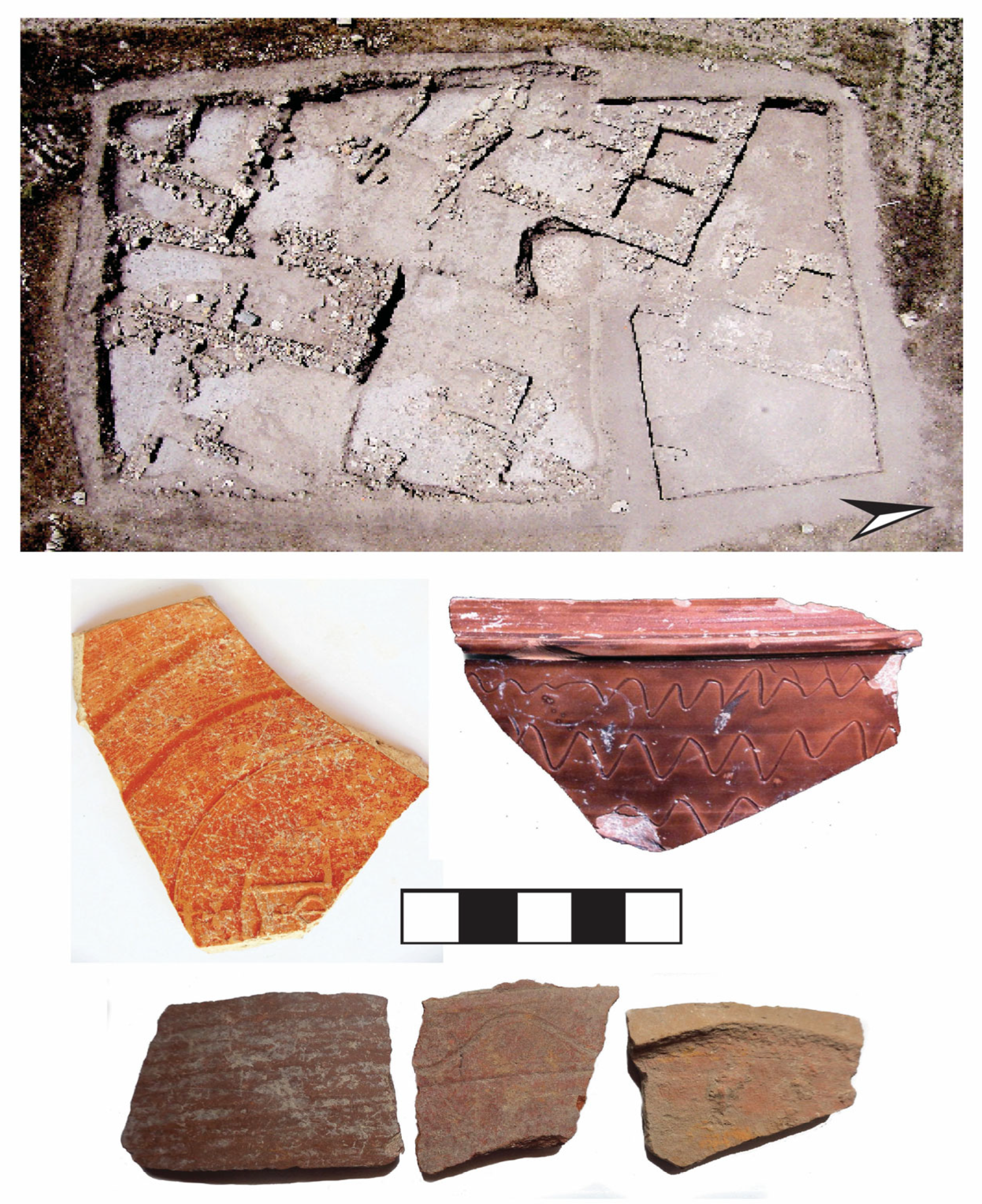
Although there is evidence for occupation back to the Roman period, Çadır Höyük’s current excavations have focused primarily on the Late Roman period (from approximately the 4th to 7th centuries) and to the medieval centuries, which include the Early Byzantine, Middle Byzantine, and early Seljuk periods (7th–13th centuries). The Late Roman constructions at the site are principally found on the terrace and are marked by what we would expect to find at a rural site in this period [110]: a well-maintained house, with evidence for courtyards, porticoes, and storage (Figure 18, top). It probably represented a localized villa-type structure, although the exact dimensions and format will remain unclear until excavation of the house resumes. Nevertheless, the material culture, through the presence of coinage and imitation red slip ware, speaks to a site with connections to the coast of Asia Minor (Figure 18, middle left). Indeed, although the majority of recovered coins date to the 11th century, this is followed in number by those from the 4th to 6th centuries, with a final Late Roman coin belonging to Justin II (565–574 CE). Further, the presence of a camel bone on the terrace also suggests a connection to the outside world [47]. As noted above, Çadır was part of the network of Late Roman sites in the region that included Kerkenes, Aliṣar Höyük, Tavium (Yozgat), and Sarıkaya. Thus, even without a large number of luxury goods or an extensive collection of fine wares, we can posit a consistent connection to the Mediterranean coast.
The “end” of the Late Roman period in the 6th century led to a period of change on the Anatolian plateau. While some sites disappeared, many continued to function as small rural households. The stratigraphy on the terrace at Çadır Höyük suggests this, as the household continued in use throughout this period. It is the material culture from these levels that illustrates this period in the early Byzantine period. The material culture, primarily ceramics, illustrates an early Byzantine occupation through the presence of locally made imitation wares. The stratigraphy indicates a continuous occupation, one marked by a decline in the structures and by a complete absence of coinage or imported wares. These are common characteristics of the 7th through mid-9th century at sites in Anatolia, and have been traditionally used as ways of identifying abandonment. At Çadır Höyük, however, this period is marked by the creation of new ceramic types which reflect local production. The majority of ceramics are coarse wares (in all periods), but there is an attempt to hold on to a type of pseudo-fine ware for at least part of this phase (Figure 18, middle right). But what is key is that there are almost no imports, suggesting that both the trade to the region slowed down, and that rural settlements had very little contact with the Mediterranean coastline.
These patterns track with the environmental data, which indicate a depopulation of the region resulting in the return to indigenous weeds/plants, including some reforestation on the landscape [19]. While such an observation is not specific to roads, a decrease in agricultural production meant that some land—and most likely many lesser roads—were reclaimed by the environment. Thus, while major road systems in the eastern part of Anatolia were probably maintained where needed, others were not. It seems likely, then, that the disappearance of coastal imports at sites in inland Anatolia resulted from many factors: decreasing production in Mediterranean urban centers, diminished trade, shrinking communities, and a decline in the reliability of road systems. More regional lives are visible in some texts, such as the Vita of Theodore of Sykeon, where we watch the eponymous saint travel through byways and villages, all of which seem to be very locally focused [111,112].
As noted above, during the late 9th and 10th centuries, Anatolia resurfaced as a significant focus of attention, largely due to a renewed focus on the defense of borders. Çadır Höyük underwent a complete rebuilding on the terrace, one which added extensively to the earlier structures. The main house was given new flagstone floors, and the courtyards were plastered. A utilitarian area—stable, storage, and kitchen—was added to the southern half of the house. A small fortified center was also added to the mound, one that was primarily used for small-scale industry (metallurgy) and for processing grains in its earliest iteration.
The focus on the local continues in relation to the material culture at Çadır Höyük. Larger centers seem to have had more contact with the Mediterranean; certainly, sites like Komana and Tavium have evidence for things like sgraffito ware [113]. Yet at Çadır, we still find almost nothing of any significance in the way of imports. The overall economy changes substantially; now cattle ranching becomes a major focus, as can be seen in the results from the faunal data, which show the rising prominence of cattle [47]. Local ceramics also shift, and a new kind of thin-walled ceramic with a micaceous gold-colored glaze appears at Çadır, suggesting another new local kind of pseudo-fine ware (Figure 19a). Yet, other artifacts do mark connections with external populations. Personal religious objects (Figure 19b), processional crosses, and coinage almost certainly came in with military detachments—but in comparison with the locally-made ceramics and other local metal objects, these are statistically minimal finds. They are largely portable items, connected to individuals, primarily dating to the 10th and 11th centuries. Thus, while rebuilding, and connections to the coast increased, these small communities remained self-sufficient and localized. A minor passage in a Middle Byzantine strategic military manual On Skirmishing admiringly discusses attacks that happened in the past, “among the villages,” (i.e., offroad), suggesting this self-sufficiency ([101] p. 24, [114] p. 221).
Çadır Höyük was probably abandoned by its population in the 11th century, the result of an attack that left a few dead defenders and a large stable of animals, primarily cattle, indicating that the population believed they could return. This apparent evacuation was initially attributed to a Seljuk “invasion”; however, other evidence, including recent C14 results, suggest that this abandonment may predate the organized Seljuk arrival. The abandonment of live animals—in conjunction with the death of the guards—may rather be the result of marauding Frankish and Norman mercenaries who moved fast and left destruction behind them [115,116].
This abandonment was short-lived; the site seems to have been reoccupied during the late 12th or early 13th century, and this reuse and its relation to the abandonment phase are currently being explored as the new C14 dates suggest a more complicated use of the mound in the 11–13th centuries than we have previously considered. The mound was reoccupied, possibly by local inhabitants, or more likely by Seljuk pastoralists. While there is no evidence for widespread trade in this period, communication networks with northern Mesopotamia and Syria probably increased at this point. As Belke has discussed (and as discussed above), there is evidence for road systems being continuously in use throughout this period, coming via Cappadocia, and managed by the Seljuks [97]. Thus, it seems likely that we would now find material culture coming from new areas. Again, one cannot assume any sort of major rebuilding, particularly in the 13th century, as small groups of Seljuks moved across the plateau. Rather, what we see are small raiding and pastoralist groups, and probably some seasonal usage of sites. This seems to be the case at Çadır Höyük, where some of the standing architecture is reused, windbreaks are constructed, and small areas on the mound are cleared.
Significant to this discussion is metal work at Çadır that looks very different from any seen before; these new discoveries have distinctive connections to types found in northern Mesopotamia and, indeed, even Iran (Figure 19c) ([117] pp. 104 and 122 for example). A few tiny sherds of what looks like Islamic period ceramics that parallel the famous Raqqa ware have also been found, although to date, there are no diagnostics or large sherds (Figure 19d). The combination of evidence suggests movement through the region may have shifted from the Mediterranean coast to northern Syria and Mesopotamia, including Eastern Anatolia.

5.3. Summary

Byzantine and Seljuk Çadır Höyük did not have empty shelves in terms of its ability to support itself. What the community lost after the 6th century was the type of artifact attributed to the complex Byzantine empire: the ceramics and glassware that characterize other Mediterranean sites. Rather, the appearance of new types of ceramics that are local in manufacture and design, and a dearth of luxury objects becomes the norm. Any non-local material in the Middle Byzantine period seems to be the result of individuals traveling to or through the settlement—reliquary crosses, coins, and larger religious objects, as these cannot be traced to any particular movement of trade. There appears to be a similar situation at Euchaïta ([118] pp. 222–223, 246–249). Finally, by the Seljuk period, it seems likely that material culture was coming from the east and the south, again largely as small personal objects. Evidence suggests that, while Tavium was no longer on a major north–south route, it remained connected to the wider Seljuk world. Only continued excavation will provide a more nuanced understanding of these patterns at Çadır Höyük.
The question of environmental impact on a site like Çadır Höyük is an important one, given the significance of these rural sites in the medieval period. Evidence from the site itself reflects the larger environmental data and a dramatic decrease in production in the early Byzantine period, with a resurgence in the Middle Byzantine period. However, it is too simplistic to draw a straight line between them. Rather, we need to see the site as reacting to social changes which altered the nature of the empire and the region over the longue durée. The Medieval Warm Period, for example, was one factor in the resurgence of the site, but only when taken in conjunction with the rise of the provincial aristocratic class, secure borders, and the move to herding, particularly of cattle. When the evolution of sites such as Çadır Höyük is considered, climate change becomes only one element of many that needs to be taken into consideration.

6. Discussion and Conclusions

At a macroscale level, the foregoing study demonstrated that severe climate variability, in conjunction with a constellation of other factors, had an adverse impact on ancient trade networks in all three periods. The same can certainly be said about the present-day. What is far less commonly understood is the microscale point-of-view, revealing how communities responded to decreasing provisions of goods, and indeed services, that once could be counted upon. Çadır Höyük is precisely the type of community capable of providing such data given its extremely long occupational history encompassing repeated climate events.
This study began with an overview describing the nature of the climate changes that occurred during the three periods under discussion. The study then asked and attempted to answer two interrelated questions: was there a change in the flow of trade goods to and from the Çadır Höyük community during these periods; and how did the community react to an unpredictable climate and potential “empty shelves” resulting from diminished trade? Climate proxies clearly demonstrate that the Anatolian plateau experienced climate variability in the late 4th and late 2nd millennia BCE lasting several centuries, with the same situation occurring several millennia later in the Medieval Warm Period.
Regarding the first question posed, during the Late Chalcolithic, evidence suggested a marked decrease, perhaps to just a mere trickle, of both luxury and critical resources reaching this small farming community during the height of the climate event. There were noticeable changes in settlement infrastructure, including an apparent retraction in the size of the settlement. Though it was possibly smaller in size over time, the community was never abandoned; residents apparently developed alternative strategies to account for an absent supply chain during the 5.2 ka event. The picture during the late 2nd millennium is complicated by the fall of the Hittite Empire, which itself may have been partially due to the 3.2 ka event. Residents stopped receiving provisions from the Hittite center, but conversely may have no longer been required to contribute their own resources to that same center. Nonetheless, it seems clear that fewer items were arriving at residents’ doors at this time.
Even more complicated is the situation during the medieval period, when climate was only one of many factors causing substantial variations in trade routes across the plateau. The slowdown of trade at the end of the Late Roman period reflected the effect that climate anomalies had on the larger cities on the coast, which made it increasingly difficult for material to reach the hinterland. Yet, even during periods of improving climate before and during the Medieval Warm Period, the local focus retained its importance, rendering the need for large scale trade obsolete. And so, during the Medieval Warm Period residents saw less imported “stuff” in the community.
What is equally clear in all three periods is that while the shelves were empty of luxury goods and imported wares, they were stocked full of items produced in the community itself. Çadır residents found alternative solutions to supply what was needed to continue their rural farming lifestyle. The location of this settlement in rich and well-watered farming lands, even if these yielded less during climate events, allowed inhabitants to adjust their socioeconomic strategies and innovate new uses for old materials to replace what once came from elsewhere. In this way, six millennia of residents at this small farming community demonstrated a remarkable resilience in the face of a multitude of challenges.

Author Contributions

Conceptualization, S.R.S.; methodology, S.R.S. and J.C.R.; investigation, S.R.S., J.C.R., M.C., L.D.H., A.J.L. and E.D.; writing—original draft preparation, S.R.S., J.C.R. and M.C.; writing—review and editing, S.R.S., J.C.R., M.C., L.D.H., A.J.L. and E.D.; visualization, A.J.L., E.D. and L.D.H.; project administration, S.R.S. All authors have read and agreed to the published version of the manuscript.

Funding

This research was funded by grants from the National Science Foundation (BCS #1114811), The John Templeton Foundation (Grant #62643), and the Social Sciences and Humanities Research Council of Canada (Insight Grant 435-2014-0944).

Data Availability Statement

The data that support the findings in this study are available in the cited references or from the corresponding author upon request.

Conflicts of Interest

The authors declare no conflict of interest.

References

  1. Eastwood, W.J.; Leng, M.J.; Roberts, N.; Davis, B. Holocene Climate Change in the Eastern Mediterranean Region: A Comparison of Stable Isotope and Pollen Data from Lake Gölhisar, Southwest Turkey. J. Quat. Sci. 2007, 22, 327–341. [Google Scholar] [CrossRef]
  2. Fontugne, M.; Kuzucuoğlu, C.; Karabiyikoğlu, M.; Hatté, C.; Pastre, J.-F. From Peniglacial to Holocene: A 14C Chronostratigraphy of Environmental Changes in the Konya Plain, Turkey. Quat. Sci. Rev. 1999, 18, 573–591. [Google Scholar] [CrossRef]
  3. Roberts, N.; Brayshaw, D.; Kuzucuoğlu, C.; Perez, R.; Sadori, L. The Mid-Holocene Climatic Transition in the Mediterranean: Causes and Consequences. Holocene 2011, 21, 3–13. [Google Scholar] [CrossRef]
  4. Bar-Matthews, M.; Ayalon, A. Mid-Holocene Climate Variations Revealed by High-Resolution Speleothem Records from Soreq Cave, Israel, and Their Correlation with Cultural Changes. Holocene 2011, 21, 163–171. [Google Scholar] [CrossRef]
  5. Clarke, J.; Brooks, N.; Banning, E.B.; Bar-Matthews, M.; Campbell, S.; Clare, L.; Cremaschi, M.; di Lernia, S.; Drake, N.; Gallinaro, M.; et al. Climatic Changes and Social Transformations in the Near East and North Africa During the ‘Long’ 4th Millennium BC: A Comparative Study of Environmental and Archaeological Evidence. Quat. Sci. Rev. 2016, 136, 96–121. [Google Scholar] [CrossRef]
  6. Giamali, C.; Koskeridou, E.; Antonarakou, A.; Ioakim, C.; Kontakiotis, G.; Karageorgis, A.P.; Roussakis, G.; Karakitsios, V. Multiproxy Ecosystem Responses of Abrupt Holocene Climatic Changes in the Northeastern Mediterranean Sedimentary Archive and Hydrologic Regime. Quat. Res. 2019, 92, 665–685. [Google Scholar] [CrossRef]
  7. Miebach, A.; Niestrath, P.; Roeser, P.; Litt, T. Impacts of Climate and Humans on the Vegetation in Northwestern Turkey: Palynological Insights from Lake Iznik since the Last Glacial. Clim. Past. 2016, 12, 575–593. [Google Scholar] [CrossRef]
  8. von Baeyer, M.; Şerifoğlu, T.E. Stability through Crisis: Cultural Resilience in the Face of Climatic Fluctuation from 3500 to 1300 CE at Çadır Höyük. In Winds of Change: Environment and Society in Anatolia; Roosevelt, C.H., Haldon, J., Eds.; University of Chicago Press: Chicago, IL, USA, 2021; pp. 85–116. [Google Scholar]
  9. Bini, M.; Zanchetta, G.; Perşolu, A.; Cartier, R.; Català, A.; Cacho, I.; Dean, J.R.; Di Rita, F.; Drysdale, R.N.; Finnè, M.; et al. The 4.2 ka BP Event in the Mediterranean Region: An Overview. Clim. Past. 2019, 15, 555–577. [Google Scholar] [CrossRef]
  10. Finné, M.; Holmgren, K.; Sundquist, H.S.; Weiberg, E.; Lindblom, M. Climate in the Eastern Mediterranean, and Adjacent Regions, During the Past 6000 Years—A Review. J. Archaeol. Sci. 2011, 38, 3153–3173. [Google Scholar] [CrossRef]
  11. Finné, M.; Woodbridge, J.; Labuhn, I.; Roberts, C.N. Holocene Hydro-Climatic Variability in the Mediterranean: A Synthetic Multi-Proxy Reconstruction. Holocene 2019, 29, 847–886. [Google Scholar] [CrossRef]
  12. Ran, M.; Chen, L. The 4.2 ka BP Climatic Event and its Cultural Responses. Quarternary Int. 2019, 521, 158–167. [Google Scholar] [CrossRef]
  13. Kaniewski, D.; Van Campo, E.; Guiot, J.; Le Burel, S.; Otto, T.; Bateman, C. Environmental Roots of the Late Bronze Age Crisis. PLoS ONE 2013, 8, e71004. [Google Scholar] [CrossRef]
  14. Kaniewski, D.; Marriner, N.; Bretschneider, J.; Jans, G.; Morhange, C.; Cheddadi, R.; Otto, T.; Luce, F.; Van Campo, E. 300-Year Drought Frames Late Bronze Age to Early Iron Age Transition in the Near East: New Palaeoecological Data from Cyprus and Syria. Reg. Environ. Change 2019, 19, 2287–2297. [Google Scholar] [CrossRef]
  15. Kulkova, M.A.; Kashuba, M.T.; Agulnicov, S.; Kulkov, A.; Streitsov, M.A.; Vetrova, M.; Zanoci, A. Impact of Paleoclimatic Changes on the Cultural and Historical Processes at the Turn of the Late Bronze–Early Iron Ages in the Northern Black Sea Region. Heritage 2022, 5, 2258–2281. [Google Scholar] [CrossRef]
  16. Manning, S.W.; Kocik, C.; Lorentzen, B.; Sparks, J.P. Severe Multi-Year Drought Coincident with Hittite Collapse Around 1198–1196 BC. Nature 2023, 614, 719–724. [Google Scholar] [CrossRef]
  17. Roberts, N. Boon or Curse? The Role of Climate Change in the Rise and Demise of Anatolian Civilizations. In Winds of Change: Environment and Society in Anatolia (15th International ANAMED Annual Symposium); Roosevelt, C.H., Haldon, J., Eds.; Koç University Press: Istanbul, Türkiye, 2021; pp. 5–35. [Google Scholar]
  18. Ellenblum, R. The Collapse of the Eastern Mediterranean: Climate Change and the Decline of the East, 950–1072; Cambridge University Press: Cambridge, UK, 2012. [Google Scholar]
  19. Haldon, J.; Eastwood, W.; Roberts, N.; Izdebski, A.; Fleitmann, D.; McCormick, M.; Cassis, M.; Doonan, O.; Elton, H.; Ladstätter, S.; et al. The Climate and Environment of Byzantine Anatolia: Integrating Science, History and Archaeology. J. Interdiscip. Hist. 2014, 45, 113–161. [Google Scholar] [CrossRef]
  20. Lüning, S.; Schulte, L.; Garcés-Pastor, S.; Danladi, I.B.; Galka, M. The Medieval Climate Anomaly in the Mediterranean Region. Paleoceanogr. Paleoclimatology 2019, 34, 1625–1649. [Google Scholar] [CrossRef]
  21. Steadman, S.R.; Selover, S.; Ross, J.C.; Dinç, E.; Lauricella, A.J.; Hackley, L.D.; Yıldırım, B.; Erdem, D. Rural Farmers, Climate Change, and Continued Archaeological Work at Çadır Höyük (2023–2024). Anatolica 2025, 51, 49–84. [Google Scholar]
  22. von Baeyer, M.; Smith, A.; Steadman, S.R. Expanding the Plain: Using Archaeobotany to Examine Adaptation to 5.2 ka Climate Change Event During the Anatolian Late Chalcolithic at Çadır Höyük. J. Archaeol. Sci. Rep. 2021, 36, 102806. [Google Scholar] [CrossRef]
  23. von Baeyer, M.; Steadman, S.R.; Arbuckle, B.S. Rural Fortitude at Çadır Höyük: Tracing Recovery after the 5.9 and 5.2 ka Climate Events on the Anatolian Plateau. In Tracing Transitions and Connecting Communities in the Archaeology of Western Asia: Papers Presented to Roger Matthews at the Occasion of His 70th Birthday; Glatz, C., Fernández, M.P., Richardson, A., Saymour, M., Eds.; Sidestone Press: Leiden, The Netherlands, 2025. [Google Scholar]
  24. Cassis, M.; Lauricella, A.J.; Tardio, K.; von Baeyer, M.; Coleman, S.; Adcock, S.E.; Arbuckle, B.S.; Smith, A. Regional Patterns of Transition at Çadır Höyük in the Byzantine Period. J. East. Mediterr. Archaeol. Herit. Stud. 2019, 7, 321–349. [Google Scholar] [CrossRef]
  25. Steadman, S.R.; Arbuckle, B.S.; McMahon, G. Pivoting East: Çadır Höyük, Transcaucasia, and Complex Connectivity in the Late Chalcolithic. Doc. Praehist. 2018, 45, 64–85. [Google Scholar] [CrossRef]
  26. Ross, J.C.; McMahon, G.; Heffron, Y.; Adcock, S.E.; Steadman, S.R.; Arbuckle, B.S.; Smith, A.; von Baeyer, M. Anatolian Empires: Local Experiences from Hittites to Phrygians at Çadır Höyük. J. East. Mediterr. Archaeol. Herit. Stud. 2019, 7, 299–320. [Google Scholar] [CrossRef]
  27. Steadman, S.R.; McMahon, G.; Ross, J.C. Chalcolithic, Iron Age, and Byzantine Investigations at Çadır Höyük: The 2017 and 2018 Seasons. In The Archaeology of Anatolia, Volume III: Recent Discoveries (2017–2018); Steadman, S.R., McMahon, G., Eds.; Cambridge Scholars Press: Newcastle upon Tyne, UK, 2019; pp. 33–52. [Google Scholar]
  28. Huang, H.; von Lampe, M.; van Tongeren, F. Climate Change and Trade in Agriculture. Food Policy 2011, 36 (Suppl. 1), S9–S13. [Google Scholar] [CrossRef]
  29. Martínez-Martínez, A.; Esteve-Pérez, S.; Gil-Pareja, S.; Llorca-Vivero, R. The Impact of Climate Change on International Trade: A Gravity Model Estimation. World Econ. 2023, 46, 2624–2653. [Google Scholar] [CrossRef]
  30. Northey, S.A.; Mudd, G.M.; Werner, T.T.; Jowitt, S.M.; Haque, S.; Yellishetty, M.; Weng, Z. The Exposure of Global Base Metal Resources to Water Criticality, Scarcity and Climate Change. Glob. Environ. Change 2017, 44, 109–124. [Google Scholar] [CrossRef]
  31. Ocakoğlu, F.; Çilingiroğlu, Ç.; Potoğlu Erkara, I.; Ünan, S.; Dinçer, B.; Akkiraz, M.S. Human-Climate Interactions Since the Neolithic Period in Central Anatolia: Novel Multi-Proxy Data from the Kureyşler area, Kütahya, Turkey. Quat. Sci. Rev. 2019, 213, 1–17. [Google Scholar] [CrossRef]
  32. Şenkul, Ç.; Memiş, T.; Eastwood, W.J.; Doğan, U. Mid-to Late-Holocene Paleovegetation Change in Vicinity of Lake Tuzla (Kayseri), Central Anatolia, Turkey. Quarternary Int. 2018, 486, 98–106. [Google Scholar] [CrossRef]
  33. Mayewski, P.A.; Rohling, E.E.; Stager, J.C.; Karlén, W.; Maasch, K.A.; Meeker, L.D.; Meyerson, E.A.; Gasse, F.; van Kreveld, S.; Holmgren, K.; et al. Holocene Climate Variability. Quat. Res. 2004, 62, 243–255. [Google Scholar] [CrossRef]
  34. Kuzucuoğlu, C.; Dörfler, W.; Kunesch, S.; Goupille, F. Mid-to-Late Holocene Climate Change in Central Turkey: The Tecer Lake Record. Holocene 2011, 21, 173–188. [Google Scholar] [CrossRef]
  35. Ön, Z.B.; Akçer-Ön, S.; Özeren, M.S.; Eriş, K.K.; Greaves, A.M.; Çağatay, M.N. Climate Proxies for the Last 17.3 ka from Lake Hazar (Eastern Anatolia), Extracted by Independent Component Analysis of µ-XRF Data. Quarternary Int. 2018, 486, 17–28. [Google Scholar] [CrossRef]
  36. Woodbridge, J.; Roberts, C.N.; Palmisano, A.; Bevan, A.; Shennan, S.; Fyfe, R.; Eastwood, W.J.; Labuhn, I. Pollen-inferred Regional Vegetation Patterns and Demographic Change in Southern Anatolia Through the Holocene. Holocene 2019, 29, 728–741. [Google Scholar] [CrossRef]
  37. Arıkan, B. Modeling the Paleoclimate (ca. 6000–3200 cal BP) in Eastern Anatolia: The Method of Macrophysical Climate Model and Comparisons with Proxy Data. J. Archaeol. Sci. 2015, 5, 158–167. [Google Scholar] [CrossRef]
  38. Allcock, S.L. Long-term Socio-environmental Dynamics and Adaptive Cycles in Cappadocia, Turkey During the Holocene. Quarternary Int. 2017, 446, 66–81. [Google Scholar] [CrossRef]
  39. Kaniewski, D.; Guiot, J.; Van Campo, E. Drought and Societal Collapse 3200 Years Ago in the Eastern Mediterranean: A Review. Wiley Interdiscip. Rev. Clim. Change 2015, 6, 369–382. [Google Scholar] [CrossRef]
  40. Kuzucuoğlu, C. The Rise and Fall of the Hittite State in Central Anatolia: How, When, Where, Did Climate Intervene? In La Cappadoce Méridionale de la Préhistoire à l’époque Byzantine; Tibet, A., Henry, O., Beyer, D., Eds.; Institut Français D’études Anatoliennes: Istanbul, Türkiye, 2012; pp. 17–41. [Google Scholar] [CrossRef]
  41. Xoplaki, E.; Fleitmann, D.; Luterbacher, J.; Wagner, S.; Haldon, J.F.; Zarita, E.; Telelis, I.; Toreti, A.; Izdebski, A. The Medieval Climate Anomaly and Byzantium: A Review of the Evidence on Climatic Fluctuations, Economic Performance and Societal Change. Quat. Sci. Rev. 2016, 136, 229–252. [Google Scholar] [CrossRef]
  42. England, A.; Eastwood, W.J.; Roberts, C.N.; John, F.; Haldon, J.F.; Turner, R. Historical Landscape Change in Cappadocia (Central Turkey): A Palaeoecological Investigation of Annually-Laminated Sediments from Nar Lake. Holocene 2008, 18, 1229–1245. [Google Scholar] [CrossRef]
  43. Arbuckle, B. Chalcolithic Caprines, Dark Age Dairy, and Byzantine Beef: A First Look at Animal Exploitation at Middle and Late Holocene Çadır Höyük, North Central Turkey. Anatolica 2009, 35, 179–224. [Google Scholar] [CrossRef]
  44. Arbuckle, B. Animals and Inequality in Chalcolithic Central Anatolia. J. Anthropol. Archaeol. 2012, 31, 302–313. [Google Scholar] [CrossRef]
  45. Chernoff, M.C.; Harnischfeger, T.M. Preliminary Report on Botanical Remains from Çadır Höyük (1994 Season). Anatolica 1996, 22, 159–175. [Google Scholar]
  46. Smith, A. Plant Use at Çadır Höyük, Central Anatolia. Anatolica 2007, 33, 169–183. [Google Scholar] [CrossRef]
  47. Tardio, K.S.; Adcock, S.E.; Arbuckle, B. Corralled Cattle: Faunal Remains from the Late Roman and Byzantine Phases of Çadır Höyük, Turkey. In Archaeozoology of Southwest Asia and Adjacent Areas XIV; Alcantara, R., Saña Segui, M., Tomero, C., Eds.; BAR International Series: Oxford, UK, 2024; pp. 235–252. [Google Scholar]
  48. Adcock, S.E. Collapse, Complexity, and Caprines: Zooarchaeological Investigations of the Hittite State and its Afters. J. Anthropol. Archaeol. 2022, 68, 101465. [Google Scholar] [CrossRef]
  49. Steadman, S.R.; Ross, J.C.; Baumgartner, R.; Martinez, J.; Arbuckle, B.S.; Stoj, K.; McMahon, G.; Smith, A.; von Baeyer, M.; Schack, F. Learning from the Past: Managing Climate Change in the Fourth and Second Millennia BCE at Çadır Höyük. In Studies in Honour of Prof. Dr. Ayşe Tuba Ökse; Engin, A., Aykurt, A., Türkcan, A.U., Zimmermann, T., Yaşin Meier, D., Gedik Zimmermann, S., Can, Ş., Çiftçi, Ş., Ekinbaş Can, Ö., Kekeç, E., Eds.; Ege Yayınları: Istanbul, Türkiye, 2025. [Google Scholar]
  50. Steadman, S.R.; Ross, J.C.; McMahon, G.; Gorny, R.L. Excavations on the North-Central Plateau: The Chalcolithic and Early Bronze Age Occupation at Çadır Höyük. Anatol. Stud. 2008, 58, 47–86. [Google Scholar] [CrossRef]
  51. Steadman, S.R.; McMahon, G.; Arbuckle, B.S.; von Baeyer, M.; Smith, A.; Yıldırım, B.; Hackley, L.D.; Selover, S.; Spagni, S. Stability and Change at Çadır Höyük in Central Anatolia: A Case of Late Chalcolithic Globalisation? Anatol. Stud. 2019, 69, 21–57. [Google Scholar] [CrossRef]
  52. Steadman, S.R.; Hackley, L.D.; Selover, S.; Yıldırım, B.; von Baeyer, M.; Arbuckle, B.; Robinson, R.; Smith, A. Early Lives: The Late Chalcolithic and Early Bronze Age at Çadır Höyük. J. East. Mediterr. Archaeol. Herit. Stud. 2019, 7, 271–298. [Google Scholar] [CrossRef]
  53. Steadman, S.R.; McMahon, G. The 2015–2016 Seasons at Çadır Höyük on the North Central Anatolian Plateau. In The Archaeology of Anatolia, Volume II: Recent Discoveries (2015–2016); Steadman, S.R., McMahon, G., Eds.; Cambridge Scholars Press: Newcastle upon Tyne, UK, 2017; pp. 94–116. [Google Scholar]
  54. Steadman, S.R.; McMahon, G.; Ross, J.C.; Cassis, M.; Geyer, J.D.; Arbuckle, B.; von Baeyer, M. The 2009 and 2012 Seasons of Excavation at Çadır Höyük on the Anatolian North Central Plateau. Anatolica 2013, 39, 113–167. [Google Scholar]
  55. Steadman, S.R.; McMahon, G.; Ross, J.C. The Late Chalcolithic at Çadır Höyük in Central Anatolia. J. Field Archaeol. 2007, 32, 385–406. [Google Scholar] [CrossRef]
  56. Selover, S.; Hackley, L.D.; Steadman, S.R. ‘Work/Life Balance’ in Late Chalcolithic Anatolia: Household Activities and Spatial Organization at Çadır Höyük. In No Place Like Home: Ancient Near Eastern Houses and Households; Battini, L., Brody, A., Steadman, S.R., Eds.; Archaeopress: Oxford, UK, 2022; pp. 112–126. [Google Scholar]
  57. Hackley, L.D.; Yıldırım, B.; Steadman, S.R. Not Seeing is Believing: Ritual Practice and Architecture at Chalcolithic Çadır Höyük, Anatolia. Religions 2021, 12, 665. [Google Scholar] [CrossRef]
  58. Yıldırım, B.; Hackley, L.D.; Steadman, S.R. Sanctifying the House: Child Burial in Prehistoric Anatolia. Near East. Archaeol. 2018, 81, 164–173. [Google Scholar] [CrossRef]
  59. Steadman, S.R.; Şerifoğlu, T.E.; Selover, S.; Hackley, L.D.; Yıldırım, B.; Lauricella, A.J.; Arbuckle, B.S.; Adcock, S.E.; Tardio, K.; Dinç, E.; et al. Recent Discoveries (2015–2016) at Çadır Höyük on the Anatolian North Central Plateau. Anatolica 2017, 43, 203–250. [Google Scholar]
  60. Massa, M. Networks Before Empires: Cultural Transfers in West and Central Anatolia During the Early Bronze Age. Ph.D. Dissertation, Institute of Archaeology, University College London, London, UK, 2016. [Google Scholar]
  61. Branting, S.A. The Alişar Regional Survey 1993–1994: A Preliminary Report. Anatolica 1996, 22, 145–158. [Google Scholar]
  62. Sagona, A. Wagons and Carts of the Trans-Caucasus. In Essays in Honour of M. Taner Tarha; Tekin, O., Sayar, M.H., Konyar, E., Eds.; Ege Yayınları: İstanbul, Türkiye, 2013; pp. 277–298. [Google Scholar]
  63. Arbuckle, B.; (University of North Carolina, Chapel Hill, NC, USA). Personal Communication, 2025.
  64. Bașıbüyük, Z. Mineralogical, Geochemical, and Gemological Characteristics of Silicic Gemstone in Aydıncık (Yozgat-Turkey). Arab. J. Geosci. 2018, 11, 1–11. [Google Scholar] [CrossRef]
  65. Öksüz, N. Geochemical Characteristics of the Eymir (Sorgun-Yozgat) Manganese Deposit, Turkey. J. Rare Earths 2011, 29, 287–296. [Google Scholar] [CrossRef]
  66. Öksüz, N.; Okuyucu, N. Mineralogy, Geochemistry, and Origin of Buyukmahal Manganese Mineralization in the Artova Ophiolitic Complex, Yozgat, Turkey. J. Chem. 2014, 2014, 1–11. [Google Scholar] [CrossRef]
  67. Doyle, S.; Carter, T.; Geyer, J. Obsidian Sourcing at Chalcolithic–Bronze Age Çadır Höyük (Central Anatolia). In Proceedings of the Poster presented at the Annual Meeting of the Society for American Archaeology, San Antonio, TX, USA, 23 April 2014. [Google Scholar]
  68. Massa, M.; McIlfatrick, O.; Fidan, E. Patterns of Metal Procurement, Manufacture and Exchange in Early Bronze Age Northwestern Anatolia: Demircihüyük and Beyond. Anatol. Stud. 2017, 67, 51–83. [Google Scholar] [CrossRef]
  69. Gale, N.H.; Stos-Gale, S.A.; Gilmore, G. Alloy Types and Copper Sources of Anatolian Copper Alloy Artifacts. Anatol. Stud. 1985, 35, 143–173. [Google Scholar] [CrossRef]
  70. Lehner, J.W.; Yener, K.A. Organization and Specialization of Early Mining and Metal Technologies in Anatolia. In Archaeometallurgy in Global Perspective; Roberts, B.W., Thornton, C.P., Eds.; Springer: New York, NY, USA, 2014; pp. 529–557. [Google Scholar]
  71. Giles, D.L.; Kuijpers, E.P. Stratiform Copper Deposit, Northern Anatolia, Turkey: Evidence for Early Bronze I (2800 B.C.) Mining Activity. Science 1974, 186, 823–825. [Google Scholar] [CrossRef] [PubMed]
  72. Kaptan, E. Findings Related to the History of Mining in Turkey. Bull. Miner. Res. Explor. 1990, 111, 75–84. [Google Scholar]
  73. Yalçin, Ü.; Maass, A. Prähistorische Kupfergewinnung in Derekutuğun, Anatolien. In Anatolian Metal VI. Der Anschnitt, Zeitschrift für Kunst und Kultur im Bergbau; Yalçin, Ü., Ed.; Deutsches Bergbau-Museum: Bochum, Germany, 2013; pp. 153–194. [Google Scholar]
  74. Wagner, G.A.; Öztunalı, Ö. Prehistoric Copper Sources in Turkey. In Anatolian Metal I. Der Anschnitt, Zeitschrift für Kunst und Kultur im Bergbau; Yalçin, Ü., Ed.; Deutsches Bergbau-Museum: Bochum, Germany, 2000; pp. 31–67. [Google Scholar]
  75. Yalçin, Ü.; Yalçin, H.G. The Prehistoric Mining Kindlings from Derekutuğun. SDÜ Fen-Edeb. Fakültesi Sos. Bilim. Dergisi. 2019, 47, 116–129. [Google Scholar]
  76. Schoop, U.-D. Çamlıbel Tarlası: Late Chalcolithic Settlement and Economy in the Budaközzü Valley (North-Central Anatolia). In The Archaeology of Anatolia: Recent Discoveries (2011–2014), Volume I; Steadman, S.R., McMahon, G., Eds.; Cambridge Scholars Publishing: Newcastle Upon Tyne, UK, 2015; pp. 46–68. [Google Scholar]
  77. Schoop, U.-D. Çamlıbel Tarlası, ein metallverarbeitender Fundplatz des vierten Jahrtausends v. Chr. im nördlichen Zentralanatolien. In Anatolian Metal V; Yalçın, Ü., Ed.; Deutsches Bergbau Museum: Bochum, Germany, 2011; pp. 53–68. [Google Scholar]
  78. Marsh, B. Geoarchaeology of the Human Landscape at Boğazköy-Ḫattuša. Archäologischer Anz. 2010, 6, 201–207. [Google Scholar]
  79. Rehren, T.; Radivojević, M. A Preliminary Report on the Slag Samples from Çamlıbel Tarlası. Archäologischer Anz. 2010, 2010, 207–216. [Google Scholar]
  80. Stroud, E.; Bogaard, A.; Charles, M. A Stable Isotope and Functional Weed Ecology Investigation into Chalcolithic Cultivation Practices in Central Anatolia: Çatalhöyük, Çamlıbel Tarlası and Kuruçay. J. Archaeol. Sci. Rep. 2021, 38, 103010. [Google Scholar] [CrossRef]
  81. Ross, J.C.; Steadman, S.R.; McMahon, G.; Adcock, S.E.; Cannon, J.W. When the Giant Falls: Endurance and Adaptation at Çadır Höyük in the Context of the Hittite Empire and Its Collapse. J. Field Archaeol. 2019, 44, 19–39. [Google Scholar] [CrossRef]
  82. Ross, J.C. Çadır Höyük: The Upper South Slope 2006–2009. Anatolia 2010, 36, 67–87. [Google Scholar] [CrossRef]
  83. D’Agostino, A.; Orsi, V. Preliminary Report on the 2018 Excavation Season at Uşaklı Höyük (Yozgat). Kazı Sonuçları Toplantısı 2020, 41, 161–172. [Google Scholar]
  84. Mazzoni, S.; D’Agostino, A.; Orsi, V. Exploring a Site in the North Central Anatolian Plateau: Archaeological Research at Ușaklı Höyük (2013–2015). Asia Anteriore Antica 2019, 1, 57–142. [Google Scholar]
  85. von der Osten, H.H. The Alishar Hüyük Seasons of 1930–32. Part I–III (OIP 28–30); University of Chicago Press: Chicago, IL, USA, 1937. [Google Scholar]
  86. Gorny, R.L. The 2002-2005 Excavation Seasons at Çadır Höyük. The Second Millennium Settlements. Anatolica 2006, 32, 29–54. [Google Scholar] [CrossRef]
  87. Ross, J.C.; Steadman, S.R. The Middle to Late Bronze Age Transition at Çadır Höyük: Dis/Continuity. In Proceedings of the American Schools of Overseas Research, Boston, MA, USA, 22 November 2024. [Google Scholar]
  88. Cammarosano, M. Hittite Local Cults; SBL Press: Atlanta, GA, USA, 2018. [Google Scholar]
  89. Košak, S. Hittite Inventory Texts (CTH 241–250); Carl Winter: Heidelberg, Germany, 1982. [Google Scholar]
  90. Siegelová, J. Hethitische Verwaltungspraxis im Lichte der Wirtschafts- und Inventardokumente; Praha, Národní Muzeum v Praze: Praha, Czech Republic, 1986. [Google Scholar]
  91. Cannon, J.W. Painted Ceramic Traditions and Rural Communities in Hittite Anatolia. Ph.D. Thesis, University of Chicago, Chicago, IL, USA, 2020. [Google Scholar]
  92. Beran, T. Die Hethitische Glyptik von Boğazköy; Gebr. Mann Verlag: Berlin, Germany, 1967. [Google Scholar]
  93. Seeher, J. After the Empire: Observations on the Early Iron Age in Central Anatolia. In Ipamati Kistmati Pari Tumatimis: Luwian and Hittite Studies Presented to J. David Hawkins on the Occasion of His 70th Birthday; Singer, I., Ed.; Tel Aviv University: Tel Aviv, Israel, 2010; pp. 220–229. [Google Scholar]
  94. Orsi, V. The Transition from the Bronze to the Iron Age at Uşaklı Höyük: The Ceramic Sequence. In Anatolia Between the 13th and the 12th Century BCE; de Martino, S., Devecchi, E., Eds.; LoGisma Editore: Vicchio, Italy, 2020; pp. 273–316. [Google Scholar]
  95. Kealhofer, L.; Grave, P.; Marsh, B. In Search of Tabal, Central Anatolia: Iron Age Interaction at Alişar Höyük. Anatol. Stud. 2023, 73, 69–98. [Google Scholar] [CrossRef]
  96. Kealhofer, L.; Grave, P.; Marsh, B.; Steadman, S.; Gorny, R.L.; Summers, G.D. Patterns of Iron Age Interaction in Central Anatolia: Three Sites in Yozgat Province. Anatol. Stud. 2010, 60, 71–92. [Google Scholar] [CrossRef]
  97. Belke, K. Roads and Routes in Northwestern and Adjoining Parts of Central Asia Minor: From the Romans to Byzantium, with Some Remarks on their Fate during the Ottoman Period up to the 17th Century. Gephyra 2020, 20, 79–98. [Google Scholar] [CrossRef]
  98. French, D. Roman Roads and Milestones of Asia Minor; Milestones, Fasc. 3.2. Galatia; British Institute at Ankara: Ankara, Türkiye, 2012; Volume 3. [Google Scholar]
  99. Kaya, T. An Overview of Land Routes in Byzantine Anatolia (ca. 4th–7th c. CE). Lycus Derg. 2023, 8, 47–71. [Google Scholar] [CrossRef]
  100. Procopius. On Buildings; Dewing, H.B.; Downey, G., Translators; Harvard University Press: Cambridge, MA, USA, 1954. [Google Scholar]
  101. Haldon, J. The De Thematibus (‘On the Themes’) of Constantine VII Porphyrogenitus: Translated with Introductory Chapters and Notes; Liverpool University Press: Liverpool, UK, 2021. [Google Scholar]
  102. Haldon, J. Warfare, State and Society in the Byzantine World 550–1204; Routledge: London, UK, 1999. [Google Scholar]
  103. Dennis, G. Maurice’s Strategikon: Handbook of Byzantine Military Strategy; University of Pennsylvania Press: Philadelphia, PA, USA, 1984. [Google Scholar]
  104. Summers, G.D. Keykavus Kale and Associated Remains on the Kerkenes Dağ in Cappadocia, Central Turkey. Anatolia Antiq. 2001, 9, 39–60. [Google Scholar] [CrossRef]
  105. Haldon, J. Roads and Communications in Byzantine Asia Minor: Wagons, Horses, Supplies. In The Logistics of the Crusades; Pryor, J.H., Ed.; Routledge: London, UK, 2006; pp. 131–158. [Google Scholar]
  106. Haldon, J. A Critical Commentary on the Taktika of Leo VI; Dumbarton Oaks: Washington, DC, USA, 2014. [Google Scholar]
  107. Neville, L.A. Authority in Byzantine Provincial Society, 950–1100; Cambridge University Press: Cambridge, UK, 2004. [Google Scholar]
  108. Yüksel, Ç.C. Trade and Urban Development in Seljuk Anatolia. J. Art. Des. 2022, 10, 60–73. [Google Scholar]
  109. Şenyurt, H.K. Sarıkaya Roma Hamamı Tarihçesi ve 2010–2015 Yılı Kazı Çalışmaları Sonuçları, (The History of the Sarıkaya Roman Bath and Results of the 2010–2015 Excavations) Sarıkaya I; Uluslararası Bozok Sempozyumu Bildiri: Yozgat, Türkiye, 2020; pp. 110–121. [Google Scholar]
  110. Ellis, S. Early Byzantine Housing. In Secular Buildings and the Archaeology of Everyday Life in the Byzantine Empire; Dark, K.R., Ed.; Oxbow Books: Oxford, UK, 2004; pp. 37–52. [Google Scholar]
  111. Connor, C.L. Women of Byzantium; Yale University Press: New Haven, NJ, USA, 2004. [Google Scholar]
  112. Whitby, M.; Price, R. Theodore of Sykeon: The “Life” by George and the “Encomium” by Nicephorus; Liverpool University Press: Liverpool, UK, 2024. [Google Scholar]
  113. Tatbul, M.N.; Erciyas, D.B. The Potential of Quantified Surface Data in Understanding the Rural Landscapes of Middle Byzantine Komana. J. East. Mediterr. Archaeol. Herit. Stud. 2023, 11, 21–44. [Google Scholar] [CrossRef]
  114. Dennis, G. Three Byzantine Military Treatises; Dumbarton Oaks: Washington, DC, USA, 1985. [Google Scholar]
  115. Beihammer, A. Byzantium and the Emergence of Muslim-Turkish Anatolia, ca. 1040–1130; Routledge: London, UK; New York, NY, USA, 2017. [Google Scholar]
  116. Vryonis, S. The Decline of Medieval Hellenism in Asia Minor: And the Process of Islamization from the Eleventh through the Fifteenth Century; University of California Press: Berkeley, CA, USA, 1971. [Google Scholar]
  117. Canby, S.R.; Beyazit, D.; Rugiadi, M.; Peacock, A.C.S. Court and Cosmos. The Great Age of the Seljuqs; Metropolitan Museum of Art: New York, NY, USA, 2016. [Google Scholar]
  118. Haldon, J. Euchaïta: From Late Roman and Byzantine Town to Ottoman Village. In Archaeology and Urban Settlement in Late Roman and Byzantine Anatolia: Euchaïta and its Environment; Haldon, J., Elton, H., Newhard, J., Eds.; Cambridge University Press: Cambridge, UK, 2018; pp. 210–254. [Google Scholar]
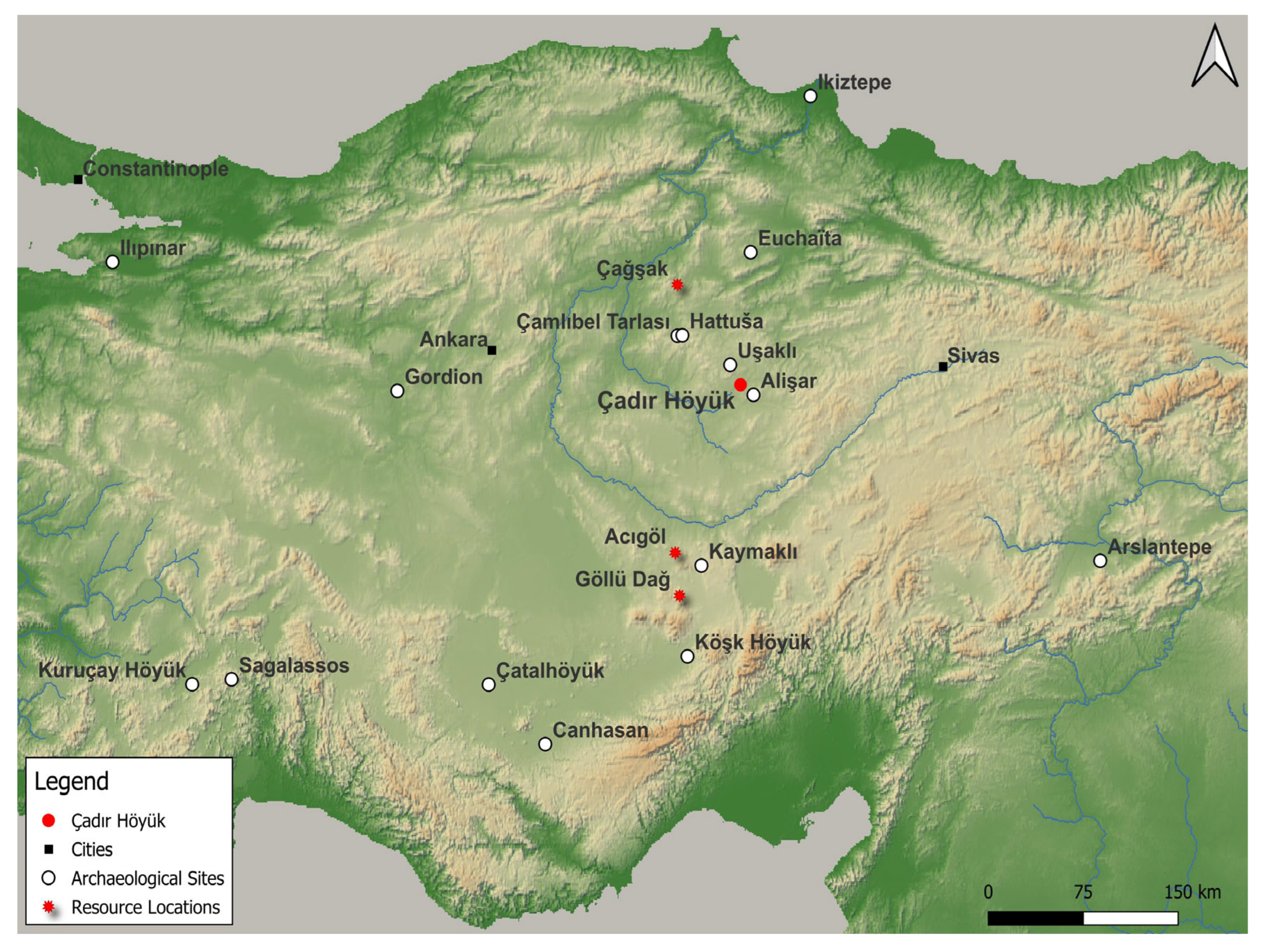
Figure 1. Map of Anatolia showing Çadır Höyük (map created by Anthony J. Lauricella).
Heritage 08 00354 g001
Figure 2. Aerial view of the Çadır Höyük archaeological site (courtesy of the Çadır Höyük Archaeological Project).
Heritage 08 00354 g002
Figure 3. Rainfall and vegetation proxy diagram of the Çadır Höyük region during the Late Chalcolithic period using the paleoclimatic data from Tecer Lake, Nar Lake, and Eski Acıgöl Lake [5,34,38] (diagram created by Emrah Dinç).
Heritage 08 00354 g003
Figure 4. Digital rendering of the probable woodland landscape around Çadır Höyük in 3200 BCE. The water south of the mound represents the Eğri Su, which fluctuated from a much smaller stream to a wider river depending on snowmelt and rainfall (photo courtesy of the Çadır Höyük Archaeological Project; Photoshop by Virginia Alvisi).
Heritage 08 00354 g004
Figure 5. Rainfall and vegetation proxy diagram of the Çadır Höyük region during the Late Bronze and the Early Iron Age using the paleoclimatic data from Tecer Lake and Eski Acıgöl [16,32,34,38,40] (diagram created by Emrah Dinç).
Heritage 08 00354 g005
Figure 6. Digital reconstruction of the probable woodland landscape surrounding Çadır Höyük just prior to the beginning of the 1200 BCE drying trend (photo courtesy of the Çadır Höyük Archaeological Project; Photoshop by Virginia Alvisi).
Heritage 08 00354 g006
Figure 7. Rainfall and vegetation proxy diagram of the Çadır Höyük region during the Middle Byzantine Period using the paleoclimatic data from Tecer Lake, Eski Acıgöl, and the vegetation data from Lake Engir [18,19,20] (diagram created by Emrah Dinç).
Heritage 08 00354 g007
Figure 8. View of Çadır Höyük today showing sparse woodland coverage of the landscape, likely similar to that during the Medieval Warm Period (photo courtesy of the Çadır Höyük Archaeological Project).
Heritage 08 00354 g008
Figure 9. Top: drawing of the combined Phase III BH 3–2 subphases in the Late Chalcolithic Lower Town at Çadır Höyük showing the major areas mentioned in the text; Bottom: aerial photos (taken in 2017) showing location of the Upper Town in relation to the Lower Town at Çadır Höyük (drawing and photos courtesy of the Çadır Höyük Archaeological Project).
Heritage 08 00354 g009
Figure 10. Top: map showing travel routes between Çadır Höyük and nearby Late Chalcolithic communities in relationship to chert and obsidian sources; Bottom: examples of chert tools (left) and obsidian flakes and tools (right) from Late Chalcolithic Çadır Höyük contexts (map created by Anthony Lauricella; photos courtesy of the Çadır Höyük Archaeological Project).
Heritage 08 00354 g010
Figure 11. Top: chart showing weights (in kilograms) of chert and obsidian tools, flakes, and cores at Late Chalcolithic Çadır Höyük during the periods discussed; Bottom: table showing percentage of obsidian in the lithic assemblage in each of the relevant periods (chart and table courtesy of the Çadır Höyük Archaeological Project).
Heritage 08 00354 g011
Figure 12. Top: examples of metal (copper) artifacts found at Çadır Höyük during the BH III 3–2 subphases, pins (left), jewelry (right), and axe (bottom); Bottom: map showing location of Çadır Höyük and nearby sites with Late Chalcolithic (and Late Bronze Age) occupations in relationship to copper ore sources (map created by Anthony Lauricella; photos courtesy of the Çadır Höyük Archaeological Project).
Heritage 08 00354 g012
Figure 13. Chart showing the weights (in grams) of copper artifacts in the Late Chalcolithic periods at Çadır Höyük (chart courtesy of the Çadır Höyük Archaeological Project).
Heritage 08 00354 g013
Figure 14. Top: chart showing the Late Chalcolithic caprine faunal assemblage data discussed in the text (chart courtesy of the Çadır Höyük Archaeological Project); Bottom: reconstruction of a Late Chalcolithic herd with a mix of sheep and goat, Çadır Höyük in the distance (watercolor drawing courtesy of Laurel D. Hackley).
Heritage 08 00354 g014
Figure 15. Top: Aerial photo of mound showing locations of the eastern slope Step Trench and the primary Late Bronze/Iron Age trenches on the Upper Southern Slope; Bottom: reconstruction of the Hittite wall at Çadır Höyük, the Step Trench tower on the left (photo courtesy of the Çadır Höyük Archaeological Project; watercolor drawing courtesy of Laurel D. Hackley).
Heritage 08 00354 g015
Figure 16. Late Bronze Age artifacts from Çadır Höyük mentioned in text: incised bone/ivory bird (top), copper nail or pin (top right), bone pin and plaque (middle), stamp seal with image of griffin (bottom left), and stamp seal with geometric design (bottom right) (photo courtesy of the Çadır Höyük Archaeological Project).
Heritage 08 00354 g016
Figure 17. Map showing Çadır and other Byzantine-era sites discussed in the text (map created by Anthony Lauricella).
Heritage 08 00354 g017
Figure 18. Top: aerial view of the North Terrace Byzantine occupation; Middle: example of red slip ware found at Çadır Höyük (right), example of pseudo fine wear (left); Bottom: examples of local coarse wares at Çadır Höyük (photos courtesy of the Çadır Höyük Archaeological Project).
Heritage 08 00354 g018
Figure 19. (a). Example of a micaceous vessel with gold-colored glaze; (b). Example of one of many personal religious crosses found at Çadır; (c). Example of the metal finds that may have originated in Mesopotamia or Iran; (d). Example of Raqqa ware (photos courtesy of the Çadır Höyük Archaeological Project).
Heritage 08 00354 g019
Table 1. Table listing the six major climate events mentioned in the text, their corresponding archaeological periods in Anatolia, and references discussing each event.
Climate EventCalendar DateArchaeological Period in Anatolia
5.9 ka3900 BCELate Chalcolithic [1,2,3]
5.2 ka3200 BCELate Chalcolithic [3,4,5]
4.8 ka2800 BCEEarly Bronze 1 [6,7,8]
4.2 ka2200 BCEEarly Bronze 3 [9,10,11,12]
3.2 ka1200 BCELate Bronze Age [13,14,15,16,17]
Medieval Warm Period900-1200 CEMiddle Byzantine [18,19,20]
Table 2. Table describing the Çadır Höyük names and dates of the Late Chalcolithic and Early Bronze Age stratigraphic phases relevant to the discussion, with corresponding subphases and descriptions of climatic periods.
PhaseSubphaseTentative DatesClimate Event
Phase III
(“BH”)
BH 3ca. 3600–3300 BCEClimatic Stability
(Humid Intermission)
Phase III
(“BH”)
BH 2ca. 3300–3200 BCEClimatic Stability/Variability
(Humid Intermission
& Lead Up)
Phase III
(“BH”)
BH 1ca. 3200 BCEOnset of
5.2 ka event
Phase II
Transitional
Tr 3–1ca. 3200–3000 BCEDuring/After 5.2 ka
Phase I
Early Bronze
(“EB”)
EB 3–1ca. 3000–2800 BCEAfter 5.2 ka
(Recovery Period)
Disclaimer/Publisher’s Note: The statements, opinions and data contained in all publications are solely those of the individual author(s) and contributor(s) and not of MDPI and/or the editor(s). MDPI and/or the editor(s) disclaim responsibility for any injury to people or property resulting from any ideas, methods, instructions or products referred to in the content.